5 Circulation & Parking
|
|
|
- Peregrine Gray
- 6 years ago
- Views:
Transcription


1 5 Circulation & Parking Downtown Parking & Circulation Strategy. Downtown Wayne has a somewhat disconnected system of local public streets to connect downtown with the residential neighborhoods, and primary roads to carry motorists through the downtown (Wayne and Michigan one-way pairs). Existing circulation issues include confusing routes, cul-de-sac side streets, one-way circulation, disconnected parking areas interspersed with former grid pattern, and incomplete parallel routes to the one-way pairs. Downtown auto speeds are perceived to be too high, especially along the primary roads, and street design and traffic control favors autos over pedestrians. Downtown Wayne Master Plan The redevelopment plan proposes a set of standards for pedestrianscale, traditional downtown streets, with parking mostly in the side and rear of buildings. Wide street and lane widths, and large building setbacks with front parking can contribute to excessive speeds. Reduced width for travel lanes or the number of travel lanes in combination with the location of infill development have been designed to foster safe pedestrian environment. The transportation recommendations complement the redevelopment plan. 49

2 Circulation & Parking Extending and Connecting Existing Streets. Wayne s original grid street pattern was significantly impacted by the one-way pairs that were added several decades ago. The lack of through and connecting streets in between and around these oneway pairs makes accessing the Downtown confusing and negatively impacts walkability and connectivity. The following extensions/connections are critical to improving accessibility to Downtown Wayne. Extending and connecting key streets improves circulation, restores more of the original grid layout, and provides better access to downtown. Sims Street. With a signalized intersection at Wayne Road, Sims Street is an asset to circulation in and around the retail core area. In conjunction with redesigning the rear parking areas west of Wayne Road, extending Sims through to the cemetery would boost this historic block and cohesively tie together the river corridor, theater, and housing developments. Main Street. Once the spine of downtown s grid, Main Street is little more than a disconnected side street and access drive. Extending a one-way eastbound Main Street access, and extending at least a more pronounced parking drive and sidewalks through from Newberry to Elizabeth is critical to linking the residential neighborhood the west with the retail core. Veterans Plaza Connector. Confusing one-way street and parking structure entrances, cul-de-sac side street, and poor pedestrian 50

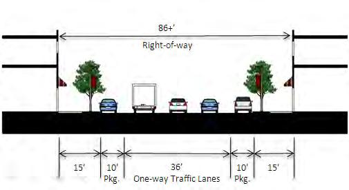
3 connections would be significantly improved with a two-way access between eastbound Michigan and Veterans Plaza. Newberry Street. The redevelopment plan places emphasis on walkable streets and connectivity to break up the large districts with more connections. To this end, Newberry should be extended south of eastbound Michigan to Wayne Road, and studied for signalization to aid vehicular and non-motorized traffic. Michigan Avenue (US-12) One-Way Pairs. For much of the 1990 s and 2000 s, the Michigan Avenue one-way pair configuration has generally been 4 lanes in each direction, with one lane of on-street parking on a part of westbound Michigan Avenue. Current and projected traffic volumes show excess capacity that should be able to be effectively accommodated by three through lanes (with turn lanes at certain intersections), as westbound now functions well. Downtown Wayne Master Plan Westbound Michigan Avenue. A recent construction project resulted in MDOT striping the left-most through lane of westbound as a dedicated turn lane and on-street parking lane between 4 th and Elizabeth Streets, making westbound a 3-lane one-way configuration. The dedicated left turn lanes (between Wayne and Elizabeth) are long and promote high-speed traffic, and could be more effectively used for some additional on-street parking. MDOT should truncate the left-turn lane to 50 and replacing it with onstreet parking, and removing the right-turn lane at Elizabeth. Current and projected traffic volumes along Michigan Avenue should be handled effectively with 3 lanes in each direction. Eastbound Michigan Avenue. While eastbound was not part of the construction project on westbound, volumes and observed traffic patterns support turning one of the four through lanes into on- 51

4 Circulation & Parking street parking, most likely on the south side of the street to provide parking and a physical buffer between residential uses and the heavy traffic along Michigan Avenue. The parking may need to be on the north side of the street to allow it s width to be used for dedicated turn lanes at Elizabeth, Newberry, and Wayne. Wayne Road. As the main north-south road through the city, Wayne Road connects the downtown to Westland s Ford Road and Westland Mall commercial areas, and provides a route for commuters accessing Michigan Avenue. Currently under the jurisdiction of Wayne County, the road is a 5- lane cross section (with a center left-turn lane) with little excess right-of-way for parking or even wide sidewalks and landscaping. The county reconfigured the street to be 5-lanes around 1990 to handle more through traffic. Since then, the city has invested in property and constructed municipal parking lots behind many of the businesses to help them remain viable. This plan recommends evaluating on-street parking and installation of center medians to address uncomfortable traffic speeds and lack of right-of-way for landscaping/gateway features To calm traffic, improve the environment for pedestrians and bicyclists, and improve aesthetics of this traditional shopping area, the city should engage the county in negotiations to enhance the street with on-street parking and center landscaped medians. Wayne Road could benefit from improved aesthetics and calmer traffic if enhancements are implemented. Reintroducing On-street Parking. The lack of parking and proliferation of businesses set right up to the street wall along the north portion of Wayne Road would be a top priority for reintroducing on-street parking. Two alternative treatments are to convert the outside lanes to parking and install bump-outs at intersections, or a less permanent treatment would just be to stripe the outside lanes for parking and add meters and signage. Lower traffic volumes mean either treatment could more easily be implemented on Wayne Road south of eastbound Michigan Avenue, if the city and area businesses desire. 52
 for the approximate width of the current lane would provide refuge for more pedestrian crossings, aesthetic")

5 Installing a Landscaped Median. Especially in the area between the Rouge River and the railroad viaduct, the center left turn lane along Wayne Road is only utilized at a few spots. Installation of a landscaped median (with left turn pockets at higher volume turn areas) for the approximate width of the current lane would provide refuge for more pedestrian crossings, aesthetic enhancements, and calm traffic moving through the downtown. The median treatment would have similar benefits extended the length of Wayne Road. Non-motorized and Transit. Connectivity with existing sidewalks, pathways, and recreational amenities has tremendous potential as an asset of the downtown area, especially if a commuter rail station is added. Downtown Wayne Master Plan Non-Motorized Connectivity. Connecting the long blocks parallel with Michigan Avenue to the River Parkway and path requires more prominent design including textured pavement, wayfinding signage, and landscaping to demark the connection and call attention from Michigan Avenue. Long blocks and lack of signalized crosswalks makes connectivity limited across the downtown. Several recommendations would improve wayfinding, enhance visibility and use of facilities, and support a future commuter rail stop. Transit Enhancements/Commuter Rail Station Area. A number of assets are already in place within a 5-minute walk of the potential rail station; promoting investment in wider sidewalks, wayfinding signage, and streetscape amenities will support a vibrant station and maximize benefit of other redevelopment projects. 53
6 Circulation & Parking Cross sections. As construction projects, redevelopment, and streetscape enhancements arise, the City should work with the county and MDOT to revise the street character throughout the downtown in support of the vision and revitalization plans set forth in this plan. The following general cross-sections support the goals of this plan in making downtown walkable, easy to navigate, and having a more urban liveable form. Eastbound/Westbound Michigan Avenue. While one-way pairs are not the most ideal configuration for downtown character and form, they are a safe and effective way to move traffic through a corridor. To more effectively balance the through traffic and local traffic, pedestrians, and bicyclists, the cross section should feature narrower (and only 3 through) lanes, on-street parking, streetscape enhancements, and buildings built close to the street whenever possible. Eastbound generally has less right-of-way than westbound, meaning eastbound only one side can have on-street parking in a 3-lane cross section. Wayne Road. As recently as the 1980 s, Wayne Road north of the Rouge River had on-street parking on both sides of the street. Traffic volumes haven t increased much, although the city has invested significant funds to purchase, clear, and construct municipal parking lots behind many businesses to offset the impacts of losing the on-street parking. Still, the city should regularly evaluate and discuss with the county (which has jurisdiction) the merits of reintroducing on-street parking with a 3-lane cross section, or introducing a median in the center lane with no onstreet parking. Limited distance between buildings and traffic and risky 5-lane crossings present a hostile environment for pedestrians. On-street parking and/or a median island would calm traffic, buffer pedestrians, and provide refuge for those crossing the street. Standard Downtown Streets. Aside from Michigan Avenue and Wayne Road, the other downtown streets should generally follow a consistent format: a narrow street width (40 ) with 2-lane traffic (1 lane each direction), with on-street parking on both sides of the street. Streets with heavier traffic such as 2 nd, Elizabeth, and Sims, may require an additional center left-turn lane to accommodate turns, especially at signalized intersections. Bump-outs and wide, aesthetic sidewalks should be included to promote pedestrian foot traffic and downtown environment. 54

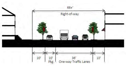
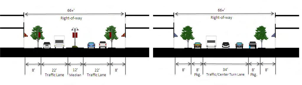
7 Downtown Wayne Master Plan Eastbound/Westbound Michigan Avenue. Wayne Road. Standard Downtown Streets. 55
8 Circulation & Parking 56
Chapter 3: Multi-Modal Circulation and Streetscapes
 CHAPTER 3: MULTI-MODAL CIRCULATION AND STREETSCAPES Chapter 3: Multi-Modal Circulation and Streetscapes Overview Streetscape improvements have already been completed for Depot Street between Main Avenue
Vision: Traditional hamlet with an attractive business/pedestrian friendly main street connected to adjacent walkable neighborhoods
 N D. Focus Area II Vision: Traditional hamlet with an attractive business/pedestrian friendly main street connected to adjacent walkable neighborhoods Transit Road Focus Area II is located in the Hamlet
Chapter 2: Standards for Access, Non-Motorized, and Transit
 Standards for Access, Non-Motorized, and Transit Chapter 2: Standards for Access, Non-Motorized, and Transit The Washtenaw County Access Management Plan was developed based on the analysis of existing
C C C
 C-012-001 Thank you for your support for the creation of new public space and nonmotorized access between downtown and the waterfront through the Overlook Walk, the East-West Connections, and the Promenade.
COWETA HIGH SCHOOL AND EAST HIGHWAY 51
 COWETA HIGH SCHOOL AND EAST HIGHWAY 51 Lack of sidewalks along Ben Lumpkin Rd. Lack of crosswalks and ramps at intersection. Hwy 51 is wide to cross as a pedestrian. No ADA compliance or connection to
S T A T I O N A R E A P L A N
 The Circulation and Access Plan describes vehicle, pedestrian, and transit improvements recommended within the Concept Plan. In order to create and sustain a vibrant business district that provides pedestrian-friendly
Streetscape: Core Shopping District
 Streetscape: Core Shopping District DRAFT DRAFT DRAFT May 00 Core Shopping District: Phase Blue Island s Core Shopping District is located along Western Avenue, between Grove and Union Streets. Streetscape
NEWMARKET UPHAM S CORNER
 SOUTH STATION Planning Initiative NEWMARKET UPHAM S CORNER COLUMBIA ROAD (P) FOUR CORNERS/GENEVA Working Advisory Group (WAG) Meeting #5 TALBOT AVENUE MORTON STREET BLUE HILL AVE/CUMMINS HWY (P) RIVER
COMPLETE STREETS PLANNER S PORTFOLIO
 COMPLETE STREETS PLANNER S PORTFOLIO ISSUE 3 APRIL 2016 PLANNER S PORTFOLIO COMPLETE STREETS 1 2 6 10 14 OVERVIEW MATURE NEIGHBORHOODS GROWING SUBURBS CENTRAL PLACES ACTIVITY CORRIDORS Planner s Portfolio
Item to be Addressed Checklist Consideration YES NO N/A Required Description Complete Streets Guidelines
 Passaic County Complete Streets Checklist - Concept Development Project Name Item to be Addressed Checklist Consideration YES NO N/A Required Description Complete Streets Guidelines Existing Plans Have
APPENDIX A: Complete Streets Checklist DRAFT NOVEMBER 2016
 APPENDIX A: Complete Streets Checklist DRAFT NOVEMBER 2016 Complete Streets Checklist MetroPlan Orlando s Complete Streets Checklist is an internal planning tool for staff to further implementation of
Newport City Thoroughfare Plan
 Newport City Thoroughfare Plan Summary This plan is intended to review and make recommendations for Newport City s thoroughfare network, in consideration of the full range of uses of the city s streets.
7 Complete Streets & Roadway Aesthetics
 7 Complete Streets & Roadway Aesthetics 7.1 OVERVIEW Our streets lay the foundation for how we interface with travel needs, physical exercise, social exchanges and access to goods and services. They are
STONY PLAIN ROAD STREETSCAPE
 Jasper Place Revitalization Strategy: Vision The people involved in the Jasper Place Revitalization Strategy envision: Goal 1: Feeling safe in our community Create a community where feeling safe is common--where
o n - m o t o r i z e d transportation is an overlooked element that can greatly enhance the overall quality of life for the community s residents.
 N o n - m o t o r i z e d transportation is an overlooked element that can greatly enhance the overall quality of life for the community s residents. 84 Transportation CHAPTER 11 INTRODUCTION Transportation
12/4/2016 VIA . RE: Grocery Outlet Del Paso (DR16-328)
") 12/4/2016 VIA EMAIL Ethan Meltzer, Assistant Planner City of Sacramento Community Development Department 300 Richards Blvd, 3 rd Floor Sacramento, CA 95811 RE: Grocery Outlet Del Paso (DR16-328) Dear Mr.
12/4/2016 VIA EMAIL Ethan Meltzer, Assistant Planner City of Sacramento Community Development Department 300 Richards Blvd, 3 rd Floor Sacramento, CA 95811 RE: Grocery Outlet Del Paso (DR16-328) Dear Mr.
ROUTE 81 CORRIDOR STUDY DESIGN CONCEPTS
 RT 81 Corridor Study CLINTON ROUTE 81 CORRIDOR STUDY DESIGN CONCEPTS View north on High Street, with potential improvements to the streetscape Draft Recommendations November 8 th, 2018 TOWN OF CLINTON
Make Lincoln Highway an economically vibrant corridor that is safe, efficient, and beautiful for local residents and visitors.
 Lincoln Highway Streetscape Plan Stakeholder Workshop #2 Handout Contents Introduction and Project Vision Planning Principles Specific Recommendations including a Proposed Typical Roadway Section Renderings
Circulation Improvement Strategy. Chapter 5: Improvement Strategy. Cross Street Neighborhood Improvement Plan
 Circulation Improvement Strategy Chapter 5: Circulation Improvement Strategy Circulation Observations: Sidewalks are located throughout most of the neighborhood, although several sidewalks do not have
A CHANGING CITY. of Edmonton, it is essential that it reflects the long-term vision of the City.
 A CHANGING CITY By the year 2040, Edmonton will be home to more than 1 million people. To accommodate growth and support a healthy and compact city, we need a new approach to development/redevelopment
Prince George s County plans, policies, and projects
 Prince George s County plans, policies, and projects Over 250 projects for trails, bikeways, designated bike lanes and sidewalk construction Trail projects that improve access to Metro Sidewalk and trail
summary of issues and opportunities
 1 summary of issues and opportunities EXECUTIVE SUMMARY CHAPTER 2: HISTORY - 3: LAND USE This first chapter is an overview of lessons learned from analysis of the existing conditions on El Camino as well
East Burke Transportation, Safety and Capacity Improvements
 East Burke Transportation, Safety and Capacity Improvements The purpose of this project is to increase mobility and improve safety for pedestrians, cyclists, and motor vehicles along VT Route 114 in the
Cherry Creek Transportation and Land Use Forum September 25, 2013 Meeting Summary
 Cherry Creek Transportation and Land Use Forum September 25, 2013 Meeting Summary I. LEAD-IN TO SMALL GROUP DISCUSSION, POLLING AND STEERING COMMITTEE/TECHNICAL TASK FORCE DISCUSSION The meeting began
Sacramento Grid 2.0. The Downtown Transportation Study
 Sacramento Grid 2.0 The Downtown Transportation Study April 20, 2016 The Grid 4.25 square miles Street grid defined at birth of City Lettered and numbered streets spaced every 400 ft East-west alleys halfway
Summary: Mercer County Princeton Avenue & Spruce Street Study January 2009
 Summary: Several recent studies have assessed potential development and redevelopment opportunities in the Mercer Crossing area of Trenton, Ewing, and Lawrence. This Princeton Avenue and Spruce Street
WELCOME. Purpose of the Open House. Update you on the project. Present a draft recommended plan. Receive your input
 WELCOME Purpose of the Open House The Town of Smiths Falls has initiated the Beckwith Street Redevelopment Plan that includes the preparation of a streetscape functional design for the renewal of Beckwith
Public Information Centre
 WELCOME Public Information Centre Father Tobin Road Lougheed Middle School - Library Wednesday November 7, 2012 7:00 p.m.to 9:00 p.m. Please sign in Neighbourhood Traffic Calming Guide Background The City
CITY OF OTTAWA ROADWAY MODIFICATION APPROVAL UNDER DELEGATED AUTHORITY
 RMA-2015-ATM-038 CITY OF OTTAWA ROADWAY MODIFICATION APPROVAL UNDER DELEGATED AUTHORITY DATE: April 22, 2015 SUBJECT Approval of Roadway Modifications Recommended through an Area Traffic Management Study
NJDOT Complete Streets Checklist
 Background The New Jersey Department of Transportation s Complete Streets Policy promotes a comprehensive, integrated, connected multi-modal network by providing connections to bicycling and walking trip
Illustrated Principles of Good Planning
 Illustrated Principles of Good Planning The Miami 21 Zoning Code incorporates time-tested planning principles into the zoning regulations of our City. These are principles that make for better neighborhoods,
CONNECTING PEOPLE TO PLACES
 CONNECTING PEOPLE TO PLACES 82 EAST BENCH MASTER PLAN 07 Introduction The East Bench transportation system is a collection of slow moving, treelined residential streets and major arteries that are the
PRINCE GEORGE S PLAZA METRO AREA PEDESTRIAN PLAN
 PRINCE GEORGE S PLAZA METRO AREA PEDESTRIAN PLAN May 28, 2008 Agenda Welcome and introductions Project overview and issue identification Planning context and strengths Design challenges and initial recommendations
FOCUS AREA 1 - Alberta Avenue Pocket Park 3 (121 Ave and 92 St)
") FOCUS AREA 1 - Alberta Avenue Pocket Park 3 (121 Ave and 92 St) New benches Plant evergreen trees Widen existing sidewalk from 1.5m to 1.8m Marked crosswalk 1.8m wide sidewalk Add pedestrian oriented lights
FOCUS AREA 1 - Alberta Avenue Pocket Park 3 (121 Ave and 92 St) New benches Plant evergreen trees Widen existing sidewalk from 1.5m to 1.8m Marked crosswalk 1.8m wide sidewalk Add pedestrian oriented lights
5 CIRCULATION AND STREET DESIGN
 5 CIRCULATION AND STREET DESIGN This chapter describes circulation and streetscape improvements proposed for the Northwest Chico Specific Plan Area. It includes detailed design specifications for existing
Agenda. Overview PRINCE GEORGE S PLAZA METRO AREA PEDESTRIAN PLAN
 PRINCE GEORGE S PLAZA METRO AREA PEDESTRIAN PLAN May 28, 2008 Agenda Welcome and introductions Project overview and issue identification Planning context and strengths Design challenges and initial recommendations
Princeton Avenue and Spruce Street Transportation and Site Access Enhancements Project
 Princeton Avenue and Spruce Street Transportation and Site Access Enhancements Project Mercer County Planning Division AECOM Transportation (formerly DMJM Harris) January 29, 2009 Agenda Project Status
Transportation Corridor Studies: Summary of Recommendations
 Transportation Corridor Studies: Summary of Recommendations Route 4 Corridor Study: Route 10 Corridor Study: Route 44 Corridor Study: Route 175 Corridor Study: Route 5/15 Corridor Study: Rentschler Field
Chapter 5 Future Transportation
 Chapter 5 Future Transportation The Future Land Use Plan identifies the desired land use designations. The land uses desired for Crozet depend, in large part, on the success of the transportation system,
Cross Street Corridor Non-Motorized Enhancement Project Project Description
 Cross Street Corridor Non-Motorized Enhancement Project Project Description A cooperative study of the Cross Street neighborhood was completed in May 2002 by the City of Ypsilanti, the Depot Town Downtown
Mission-Geneva Transportation Study Community Workshop 2 July 8, 2006
 Community Workshop 2 July 8, 2006 Small Group Workbook 1 Basic Improvements on Mission Street Streetscape. Pedestrian-scale lighting; landscaping; community art on utility boxes; more (possibly unique)
El Centro Mobility Hub
 The El Centro drive shed comprises a major portion of the El Centro downtown area, which is well served by bus routes. The proposals intend to promote use of public transit through improvements and enhancements
TRANSPORTATION STANDARDS
 INTRODUCTION LOCAL STREETS ON-STREET PARKING SIDEWALKS STREET LIGHTING STREET FURNISHINGS TRAFFIC CALMING STREET TREES MEDIAN PLANTING BOULEVARD LOCATIONS VILLAGE CENTER STREET LOCATIONS RESIDENTIAL STREET
CITY OF COCOA BEACH 2025 COMPREHENSIVE PLAN. Section VIII Mobility Element Goals, Objectives, and Policies
 CITY OF COCOA BEACH 2025 COMPREHENSIVE PLAN Section VIII Mobility Element Goals, Objectives, and Policies Adopted August 6, 2015 by Ordinance No. 1591 VIII MOBILITY ELEMENT Table of Contents Page Number
EXECUTIVE SUMMARY: TRANSIT-ORIENTED DEVELOPMENT IN SMITHS FALLS, ONTARIO; A COMPARISON BETWEEN TWO SITES
 EECUTIVE SUMMARY: TRANSIT-ORIENTED DEVELOPMENT IN SMITHS FALLS, ONTARIO; A COMPARISON BETWEEN TWO SITES Topic and Purpose In 2007, the Mayor of Ottawa s Task Force on Transportation suggested adding a
5. Automobile Circulation, Wayfinding and Signage
 5. Automobile Circulation, Wayfinding and Signage Policy: The City Center should have a balanced, safe, and interconnected circulation system that provides expanded travel opportunities for transit, pedestrian,
Broad Street Bicycle Boulevard Design Guidelines
 Broad Street Bicycle Boulevard Design Guidelines Building from the strategies introduced in the 2013 Bicycle Transportation Plan and community input received thus far, City Transportation Staff have identified
Bicycle Boulevards and Neighborhood Greenways
 Bicycle Boulevards and Neighborhood Greenways Traffic Safety is Improving for Everyone 90 80 70 60 50 40 30 20 10 0 PORTLAND: TOTAL TRAFFIC FATALITIES 1986-2008 1986 1987 1988 1989 1990 1991 1992 1993
US 278 Corridor Concept Presentation. Avondale Estates Intersection Improvement/Roundabout and Road Diet Feasibility Study March 19, 2015
 US 278 Corridor Concept Presentation Avondale Estates Intersection Improvement/Roundabout and Road Diet Feasibility Study March 19, 2015 Thanks to our Partners Atlanta Regional Commission Georgia Department
5. RUNNINGWAY GUIDELINES
 5. RUNNINGWAY GUIDELINES These guidelines should be considered collectively when making runningway decisions. A runningway is the linear component of the transit system that forms the right-of-way reserved
MASTER BICYCLE AND PEDESTRIAN PLAN
 VILLAGE OF NORTHBROOK MASTER BICYCLE AND PEDESTRIAN PLAN DRAFT PLAN OPEN HOUSE May 2, 2018 AGENDA 1. Community Engagement 2. Vision and Goals 3. General Structure of Plan 4. Recommendations Overview 5.
Table #6 VISION CHARACTERISTICS
 Table #6 VISION White Flint is a place to live, work, play, shop, and walk with sufficient density to encourage quality redevelopment. Vibrant streets and consistent streetscapes are important. CHARACTERISTICS
Omaha s Complete Streets Policy
 Omaha s Complete Streets Policy (Adopted August 2015) VISION To create great places and enhance our quality of life, the City of Omaha will provide safe, accessible streets for all users. Complete Streets
Las Tunas Downtown Revitalization City Council Study Session. December 1, :00 p.m. Live Oak Park Community Center
 Las Tunas Downtown Revitalization City Council Study Session December 1, 2015 7:00 p.m. Live Oak Park Community Center AGENDA 2 Provide downtown context. Confirm project goals. Analyze three design concepts.
El Camino Real Specific Plan. TAC/CAC Meeting #2 Aug 1, 2018
 El Camino Real Specific Plan TAC/CAC Meeting #2 Aug 1, 2018 Land Use Alternatives Goals and Tradeoffs Parks & open space Housing Retail & services Civic spaces Parking Community gathering spaces 3 Alternatives
Stakeholder Meeting Handouts. January 2013
 January 2013 Stakeholder Meeting Handouts The Case FOR Parking Minimum Requirements Reduce street congestion around the development site Avoid parking spillover Create orderly development patterns Anticipate
Circulation and Parking
 CHAPTER 6 Circulation and Parking A. Introduction This chapter describes the circulation recommendations for the Downtown Hemet Specific Plan, which includes recommendations for improving the roadway network,
Bicycle and Pedestrian Advisory Committee (BPAC) November 21, 2013
 November 21, 2013") Bicycle and Pedestrian Advisory Committee (BPAC) November 21, 2013 OVERALL LAND USE CONCEPT Overall Broadway Valdez District: 95.5 acres (35.1 acres right-of ways + 60.4 acres developable land) Plan Subareas:
Bicycle and Pedestrian Advisory Committee (BPAC) November 21, 2013 OVERALL LAND USE CONCEPT Overall Broadway Valdez District: 95.5 acres (35.1 acres right-of ways + 60.4 acres developable land) Plan Subareas:
MAG Town of Cave Creek Bike Study Task 6 Executive Summary and Regional Significance Report
 Page 1 MAG Town of Cave Creek Bike Study Task 6 Executive Summary and Regional Significance Report August 1, 2012 MAG Project #481 Page 2 Task 6 Executive Summary and Regional Significance Report Introduction
DRAFT - CITY OF MEDFORD TRANSPORTATION SYSTEM PLAN Roadway Cross-Sections
 Roadway Cross-Sections Medford s roadway cross-section standards apply to new and reconstructed roads. The crosssections take into consideration roadway function and operational characteristics, including
WELCOME. Thank you for joining us at the Second Public Workshop for the Carlsbad Pedestrian Master Plan. We look forward to receiving your feedback.
 City of Carlsbad Pedestrian Master Plan: WELCOME WELCOME Please Sign In Provide Input at Flip Charts Review Boards Presentation of Draft Plan Thank you for joining us at the Second Public Workshop for
Outreach Approach RENEW SF served as the primary liaison with the North Beach community; the Chinatown. Executive Summary
 Executive Summary Executive Summary The Columbus Avenue Neighborhood Transportation Study s objective is to identify changes to transportation infrastructure and policies that could enhance the livability
CITY OF BLOOMINGTON COMPLETE STREETS POLICY
 CITY OF BLOOMINGTON COMPLETE STREETS POLICY POLICY OBJECTIVE: The City of Bloomington will enhance safety, mobility, accessibility and convenience for transportation network users of all ages and abilities,
City of Novi Non-Motorized Master Plan 2011 Executive Summary
 City of Novi Non-Motorized Master Plan 2011 Executive Summary Prepared by: February 28, 2011 Why Plan? Encouraging healthy, active lifestyles through pathway and sidewalk connectivity has been a focus
Paoli Road Improvement Feasibility Study
 Paoli Road Improvement Feasibility Study & Public Participation Project March 24, 2015 Prepared for: Tredyffrin Township Prepared by: McMahon Associates, Inc. with Town Planning Partnership, LLC Glackin
Executive Summary Route 30 Corridor Master Plan
 Route Corridor Master Plan Project Overview The Route Corridor Master Plan is a coordinated multimodal transportation and land use plan for the entire stretch of Route through East Whiteland Township,
Mainstreet Master Plan Land Use
 Mainstreet Master Plan 04 Land Use Top Recommendations Active Uses: Promote active ground-floor uses such as retail, restaurants, galleries and personal services with interactive storefronts for Mainstreet
Completing the Vision
 Villas of Positano Completing the Vision North A1A Lane Reconfiguration N. Surf Rd. Redirection of Traffic Margaritaville Resort March 4, 2014 1 Completing The Vision Project Limits Hollywood Blvd. to
7/23/2017 VIA . Michael Hanebutt City of Sacramento Community Development Department 300 Richards Boulevard, 3 rd Floor Sacramento, CA 95811
 7/23/2017 VIA EMAIL Michael Hanebutt City of Sacramento Community Development Department 300 Richards Boulevard, 3 rd Floor Sacramento, CA 95811 RE: 65 th Street Apartments (DR17-220) Dear Mr. Hanebutt:
Implementation Matrix
 Downtown Delaware Parking Study Short Term Mid Term Long Term = Within one year = Within three years = More than three years The highlighted proposed enhancements will require a substantial amount of input
WELCOME Public Information Centre
 WELCOME Public Information Centre Fernforest Drive Brampton Soccer Centre Community Room #2 Tuesday January 19, 2016 6:30 p.m.to 9:00 p.m. Please sign in Neighbourhood Traffic Calming Guide Background
Lincoln Highway Streetscape Plan Concept Plan
 Lincoln Highway Streetscape Plan Concept Plan November 14, 2014 Introduction This report provides a summary of conceptual transportation, land use, and design recommendations in the Lincoln Highway Streetscape
Dr. M.L. King, Jr. Street North Complete Streets Resurfacing Opportunities HOUSING, LAND USE, AND TRANSPORTATION COMMITTEE MARCH 22, 2018
 Dr. M.L. King, Jr. Street North Complete Streets Resurfacing Opportunities HOUSING, LAND USE, AND TRANSPORTATION COMMITTEE MARCH 22, 2018 What s Happening The City plans to mill and resurface Dr. M.L.
Ocean Park Boulevard Green Street Project Alternatives & Trade Offs
 Planning Commission March 4, 2009 Ocean Park Boulevard Green Street Project Alternatives & Trade Offs Purpose of Tonight s Meeting Review concept plans and options Provide input on alternatives and trade-offs
Corporate. Report COUNCIL DATE: May 25, 1998 NO: R1500 REGULAR COUNCIL. TO: Mayor & Council DATE: April 27, 1998
 R1500 : Traffic Safety at 25 Avenue and 128 Street Intersection Corporate NO: R1500 Report COUNCIL DATE: May 25, 1998 REGULAR COUNCIL TO: Mayor & Council DATE: April 27, 1998 FROM: General Manager, Engineering
forwarddallas! Implementation Proposed Chapter 43 Code Amendment On-Street Parking
 forwarddallas! Implementation Proposed Chapter 43 Code Amendment On-Street Parking Transportation and Environment Committee Briefing December 10, 2007 PURPOSE Code amendment to establish regulations consistent
Bikeway action plan. Bicycle Friendly Community Workshop March 5, 2007 Rochester, MN
 Bikeway action plan Summary The was held on March 5, 2007 at the Rochester Mayo Civic Center. The workshop was hosted by Rochester-Olmsted County Planning Department in collaboration with the League of
PEDESTRIAN CIRCULATION & STREETSCAPE DESIGN
 CHAPTER 4 Chapter 4 Pedestrian Circulation & Trails PEDESTRIAN CIRCULATION & STREETSCAPE DESIGN In recent years, the City has constructed new sidewalks and enhanced existing ones in the downtown with brick
Roadway Classification Design Standards and Policies. Pueblo, Colorado November, 2004
 Roadway Classification Design Standards and Policies Pueblo, Colorado November, 2004 Table of Contents Page Chapter 1. General Provisions 1.1 Jurisdiction 3 1.2 Purpose and Intent 3 1.3 Modification 3
In station areas, new pedestrian links can increase network connectivity and provide direct access to stations.
 The Last Mile Planning for Pedestrians Planning around stations will put pedestrians first. Making walking to stations safe and easy is important; walking will be a part of every rapid transit Accessible
Introduction. North 12 th Complete Street Project Overview
 Introduction On Wednesday, March 1, 2017, the City of Sacramento, in partnership with Sacramento Regional Transit District and the Sacramento Housing and Redevelopment Agency, hosted a community outreach
5/31/2016 VIA . Arwen Wacht City of Sacramento Community Development Department 300 Richards Blvd., 3 rd Floor Sacramento, CA 95811
 5/31/2016 VIA EMAIL Arwen Wacht City of Sacramento Community Development Department 300 Richards Blvd., 3 rd Floor Sacramento, CA 95811 RE: El Pollo Loco (P16-028) Dear Ms. Wacht: WALKSacramento has reviewed
Non-Motorized Transportation 7-1
 Non-Motorized Transportation 7-1 Transportation facilities no longer mean just accommodating a vehicle powered by a combustion engine. Pedestrian and non-motorized facilities are important modes of travel
2014/2015 BIKE ROUTE PLAN 83 AVENUE PROTECTED BIKE LANE
 About the Project The City of Edmonton is planning a major bike route on the southside of Edmonton. The Strathcona Bike Route will connect the communities of Strathcona, Garneau and the University area,
4 MOBILITY PLAN. Mobility Plan Objectives. Mobility Context. 1. Integrate with Local and Regional Transit Improvements
 Harbor Mixed Use CHAPTER Transit Corridor 4: Mobility Plan 4 MOBILITY PLAN Mobility Plan Objectives The Harbor Corridor Plan seeks to expand and improve the ways that people move along and through the
Duwamish Way-finding and CTR Report
 V. North Tukwila When the North Tukwila Manufacturing and Industrial Center was designated in 1992 as part of the region s land use and transportation plan, the plan called for the area to set a light-rail
Traffic Improvements for the Transit Oriented Development District (TODD) Meriden Public Library March 11, 2014
 Meriden Public Library March 11, 2014") Traffic Improvements for the Transit Oriented Development District (TODD) Meriden Public Library March 11, 2014 Project Overview Coordinate roadway improvements with other major projects HUB Flood Control
Traffic Improvements for the Transit Oriented Development District (TODD) Meriden Public Library March 11, 2014 Project Overview Coordinate roadway improvements with other major projects HUB Flood Control
Solana Beach Comprehensive Active Transportation Strategy (CATS)
") Solana Beach Comprehensive Active Transportation Strategy (CATS) 3.0 Goals & Policies The Solana Beach CATS goals and objectives outlined below were largely drawn from the Solana Beach Circulation Element
Solana Beach Comprehensive Active Transportation Strategy (CATS) 3.0 Goals & Policies The Solana Beach CATS goals and objectives outlined below were largely drawn from the Solana Beach Circulation Element
SAN FRANCISCO MUNICIPAL TRANSPORTATION AGENCY
 THIS PRINT COVERS CALENDAR ITEM NO. : 10.3 DIVISION: Sustainable Streets Division BRIEF DESCRIPTION: SAN FRANCISCO MUNICIPAL TRANSPORTATION AGENCY Approving traffic and parking modifications to install
Report. Typical Sections. City of Middleton, WI
 Report Typical Sections City of Middleton, WI December 2006 Report for City of Middleton, Wisconsin Typical Sections repared by: Traffic Associates LLC and STRAND ASSOCIATES, INC. 910 West Wingra Drive
GIS Based Data Collection / Network Planning On a City Scale. Healthy Communities Active Transportation Workshop, Cleveland, Ohio May 10, 2011
 The Purpose of GIS Based Network Planning GIS Based Data Collection / Network Planning Healthy Communities Active Transportation Conference Tuesday, May 10, 2011 10:00 AM Norman Cox, LLA, ASLA. Ann Arbor,
Figure 4-10: Pedestrian Improvements Types of Potential Station Area Improvements - Place-Making Improvements
 INCORPORATE FEATURE PAVIN IN CROSSWALK AND INTERSECTION FIELDS Identifies high-priority pedestrian areas and create a station identity through colorful and interesting patterns ADD CURB EXTENSIONS Extending
MARTIN LUTHER KING JR. WAY
 OCTOBER 2011 40 Vision and Goals The Martin Luther King, Jr. Way Illustrative Master Plan that follows has been developed through a process of community involvement. It expresses a long term vision for
Welcome. If you have any questions or comments on the project, please contact:
 Welcome This drop-in public open house is intended to provide information about the Bay Street bike lanes project. This project proposes a dedicated cycling facility along Bay Street between Aberdeen Avenue
City Birmingham Multi-Modal Transportation Plan Visioning Workshop Results Meeting
 City Birmingham Multi-Modal Transportation Plan Visioning Workshop Results Meeting Monday, January 28, 2013 7:30 PM, City Hall Norman Cox, PLA, ASLA. Ann Arbor, Michigan. www.greenwaycollab.com Community
1 st and 2 nd Street Couplet FAQ s
 1 st and 2 nd Street Couplet FAQ s Q. Will the proposed roundabout at Flume/2nd/1 st Streets affect access to businesses nearby?... 2 Q. What if the project isn t received well by the community after construction?...
WEST CERVANTES STREET CORRIDOR. Northwest Florida ROAD DIET CANDIDATE
 WEST CERVANTES STREET CORRIDOR Northwest Florida ROAD DIET CANDIDATE West Cervantes Street - Context Four-lane undivided highway corridor (w/center turn lane) Urban district- Grid block development pattern
Complete Streets. Designing Streets for Everyone. Sarnia
 Complete Streets Designing Streets for Everyone Sarnia Complete Streets ~ Sarnia ~ 2018 Introduction Our City is made up of a network of streets that we use to go for a walk, cycle to work, drive to the
10/8/2014 VIA . RE: CVS Pharmacy (P13-002) Revised August 2014
 Revised August 2014") 10/8/2014 VIA EMAIL David Hung, Associate Planner Community Development Department, Current Planning Division City of Sacramento 300 Richards Boulevard, 3 rd Floor Sacramento, CA 95811 RE: CVS Pharmacy
10/8/2014 VIA EMAIL David Hung, Associate Planner Community Development Department, Current Planning Division City of Sacramento 300 Richards Boulevard, 3 rd Floor Sacramento, CA 95811 RE: CVS Pharmacy
Presentation Starts at 5:30 PM
 Presentation Starts at 5:30 PM Public Meeting #1 September 22, 2016 Purpose of Study Conceptual Complete Streets Study on South Carson Street 5 th Street to Roland Drive Approximately 2.5 miles Consider