Boating and water sports
|
|
|
- Cornelius Piers Banks
- 6 years ago
- Views:
Transcription

1 FREE! Boating and water sports in Tasman District 2017 / 2018 For more information visit: or scan this QR code with your smartphone >

2 Puponga Whanganui Inlet Pakawau Aorere Parapara COLLINGWOOD GOLDEN BAY Onekaka Patons Rock Rangihaeata Tata Bay Parapara Milnthorpe Waitapu Pohara Tarakohe TAKAKA Ligar Bay Parapara Inlet Honeymoon Bay Breaker Bay Upper Takaka Kaiteriteri Torlesse Rock Anawera Point Stephens Bay Unformed, No fee LEGEND: Hard concourse, Fee applies Unformed, no fee Hard concourse, No fee Hard concourse, fee applies Aquaculture Management Area Hard concourse, no fee Aquaculture Management Area Ngatimoti 2
3 TASMAN COAST BOAT RAMP ACCESS Not for navigation The Tasman coast is subject to New Zealand s largest tidal range. Check for hazards including logs and sandbanks before heading out on the water. Many channels and bars should only be attempted with local knowledge or on a rising tide on a calm day. Coastal boat ramps or beach launching areas exist at the areas shown on this map. There are also ramps at: Separation Point Wainui Bay Totaranui Awaroa Bay Tonga Island Bark Bay Torrent Bay Lake Rotoiti (Kerr and West Bays) Lake Rotoroa Buller River at Murchison Note: Take care to avoid scouring holes when using unsealed launching areas, as this creates a hazard for other users. Please fill any holes you create and notify the Harbourmaster if a hazard exists. Use your winch rather than powering onto your trailer. *Please note the Mapua boat ramp has restricted access. Stilwell Bay Apple Tree Bay Marahau Otuwhero Inlet Kaiteriteri Stephens Bay Riwaka MOTUEKA Jackett Island Mapua* Kina Tasman TASMAN BAY Grossi Point Orinoco Ruby Bay Bronte Waimea Inlet Bird Island Mahana Rabbit Island Rough Island RICHMOND Waimea Inlet Best Island
4 CONTENTS General Information: 5 Basic rules of the sea 6 Before you go! 6 Essential equipment 7 Safe boating 8 Swimming / Fishing 9 Night-time navigation 9 Commercial vessel operations 9 Instant fines 9 Launch wardens 10 Marine VHF radio 44 If things go wrong Tide tables and news: 18 Summer news 19 Summer news 20 Tide tables 22 Tide tables Other information: 23 Marine farms 23 Marine forecasts 24 Useful contacts 24 Tasman boating clubs 25 Special events Use of jet boats and other craft on rivers: 11 Rules and regulations Waterskiing, Towing Biscuits & PWC (Jetski): 12 Location map of ski and PWC areas and access lanes 13 Personal water craft (PWC) 13 Waterskiing 13 Places you may not waterski 14 Your obligations 14 Your rights 15 Ski access lanes and reserved areas 16 Marine reserves Location specific maps and information: 26 Collingwood 27 Port Tarakohe 28 Tata Beach 29 Totaranui 30 Torrent Bay 31 The Anchorage 32 Stilwell Bay 32 Marahau 33 Adele Island 34 Kaiteriteri 35 Port Motueka 36 Kina Peninsula 37 Mapua 37 Hunter Brown Traverse 40 Rabbit Island 41 Lake Rotoiti This brochure is printed on Rockstock which is a tree free mineral paper manufactured from milled quarry waste using no water and minimal energy Non-toxic and low GHG emissions. For more information go to 4
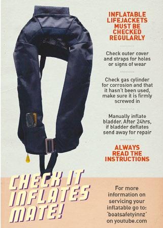
5 WELCOME Tasman District is a boating paradise, but a day out on the water can turn to disaster if you are unprepared and don t play by the rules. All boaties should know the National Navigation Safety Rules ( skipper-responsibilities) and their local Navigation Safety Bylaw Rules. Tasman District s Navigation Safety Bylaw controls all inland waterways and coastal waters up to 12 miles offshore within Tasman District. When you ski, sail, motor, jetski, row or paddle any boat in the Tasman District, you are subject to the rules in the bylaw. This brochure explains some of these rules from the current Navigation Safety bylaw. Please ensure you are up to date with the rules before heading out on the water. A full copy of the current bylaw along with other useful navigation safety information, may be viewed on the Tasman District Council website Copies of the bylaw can also be seen at Tasman District Council service centres or libraries. HARBOURMASTER CONTACT If you have any questions about boating in the Tasman District, please contact the Harbourmaster by calling any Tasman District Council office (see back cover) or harbourmaster@tasman.govt.nz BASIC RULES OF THE SEA Always keep a good lookout and travel at a safe speed. Powerboats give way to sailing, rowed or paddled vessels (e.g. kayaks). In general, alter course to starboard (right) to avoid other vessels and keep a 50 metre buffer zone. When on converging courses, the vessel looking at the port (left side and red light) of the other vessel gives way. Best action is to alter course to starboard and pass behind the right of way (stand on) vessel. Stop if necessary. All skippers should know Maritime Rule Part 22 Collision Prevention (see like all drivers should know the road code. Carry a horn and the correct lights for your vessel. Endorsed by the National Pleasure Boat Safety Forum BOAT SAFELY KNOW THE RULES Vessels overtaking: Every overtaking boat gives way (includes sailing vessels). GIVEWAY Power vessels head on: Both alter to starboard (right). GIVEWAY GIVEWAY Power vessels crossing: Power boats give way to others on their starboard side. GIVE WAY Give way boats should cross behind. Sailing vessels have different rules Lifejackets take them, wear them Skipper responsibility keep everyone safe. Know your vessel and your limits Emergency communications carry two types that work when wet (VHF, EPIRB, flare, cell phone) Marine weather check first. If in doubt don t go out Avoid alcohol Maximum speed: Within 200m of shore or dive flag. Within 50m of all boats or swimmers. BE A RESPONSIBLE SKIPPER DO A DAY SKIPPER COURSE 5
6 BEFORE YOU GO There are many navigation hazards (rocks, reefs etc) along the Abel Tasman coastline and some of these are unmarked. Boaties are advised to check their navigation charts and do thorough planning before heading out on the water. Know the boating safety code Check Coastal Forecast at before you go, and Nowcast on VHF channel 22 at sea. Conditions can change very quickly, it is important to listen in to updated maritime forecasts while out on the water. Keep your cellphone in a sealed bag in a zipped pocket. Dial 111 or VHF radio channel 16 in an emergency, flares, and a registered 406MHz EPIRB are recommended. Alcohol affects judgement and reaction times. It also changes how your body reacts when unexpectedly plunged into the water. Lifejackets must be worn when being towed, crossing a bar or in adverse conditions such as rough seas. They should be worn in vessels prone to capsize, and when travelling at high speed, especially while on rivers or riding on personal watercraft (jetskis). We recommend wearing them at all times. ESSENTIAL EQUIPMENT Lifejackets (aka Personal Flotation Devices or PFDs) one of the correct size is required for everyone on board and must be within reach, (it is important to ensure that CO2 cartridge type jackets are regularly serviced). Bailing system as well as electric bilge pumps, always have a bucket available for bailing or to use as a sea anchor. An anchor 1 1/2 kg per metre of boat length, plus chain at least equal to the boat length and at least 30 metres of warp (rope). Alternative power spare outboard and fuel, or oars in case of engine failure. Fire extinguisher one of the greatest risks at sea is from fire. Fuel fires cannot be extinguished with water. Compass and charts know where you are, where safe refuge is and where the dangers lie. A new Tasman Bay chart (NZ614) was published in September 2015, and a new Abel Tasman chart (NZ6144) was published in Communication marine VHF radios are recommended but cellphones are useful for parts of our coastline. EPIRBs must be of the new 406MHz type, and should be registered with RCCNZ for efficient rescue. If VHF is fitted, you should maintain a watch on Ch16 and hold an operator s certificate to transmit unless in an emergency. Distress flares an orange smoke for daytime use and a handheld red flare for night time use are recommended as minimum. Know how to use them in the dark! First aid kit be able to treat minor injuries. Other useful gear spare rope, torch, boat hook, sharp knife. 6
7 SAFE BOATING 1. Speed and wake Your speed must not exceed 5 knots: within 200 metres of the shore, any structure, or a diver s blue and white flag within 50 metres of any other vessel or any person in the water (unless allowed by an access lane or reserved area) if anyone is bow-riding or is leaning over the side In general, if your vessel is producing a minimal wake you will be travelling at under 5 knots. People in the water are at most risk from speeding boats, skiers and jetskiers. Remember, when there is no speed limit skippers must ensure their boat s wake does not create a risk and that they travel at a speed which is safe for the conditions. Note that 3 knot limits apply at the Anchorage, Torrent Bay and beside Adele Island, and also adjacent to the marina at Port Motueka. In these areas you should trim and adjust speed for no appreciable wake. Even if beyond the 200 metre distance from shore, you must be aware of the size of wake your vessel is generating when underway and alter speed and trim accordingly so that your wake doesn t cause a danger or nuisance to others. No one under the age of 15 may operate a motorised craft capable of exceeding 10 knots unless under direct supervision. 2. Pollution and supplies All vessels are required to comply with the marine pollution regulations. These prohibit the discharge of untreated sewage (particulate waste) within 500 metres of shore or a marine farm, 200 metres of a marine reserve, or in water less than 5 metres deep. This effectively prohibits discharge of untreated sewage within Astrolabe Roadstead, or in the greater Torrent Bay, for example. Urine is acceptable. It is also illegal to discharge plastics or oils into the water. All oil spills must by law be reported immediately to the Council s Regional On-Scene Commander on Ph or to Maritime New Zealand. Please retain all rubbish aboard for proper disposal ashore. Details of fuel and water supplies are at 3. Diving Divers and snorkellers are vulnerable to propellers and speeding boats. Keep well clear of likely diving locations like rocky headlands or anchored boats when travelling at speed. If you see a divers flag, reduce speed to dead slow within 200m, and keep a sharp watch for bubbles or people in the water. When diving from a boat, both the skipper and the divers are responsible for ensuring any approaching boat can clearly see your dive flag from at least 200m away. The flag must be over 600mm along its shortest edge. The boatman should wave it if needed, and keep the boat between the divers and any approaching boat where possible, an air horn is also a good idea to alert boaties that don t appear to have seen your dive flag. Shore-based divers are also strongly advised to tow (or anchor) a dive flag on a float when diving, for your own protection. 7
8 4. Paddling The Maritime Rules and Navigation Safety Bylaws apply to all small craft, including kayaks and paddleboards. Paddlers are encouraged to travel close to shore. Within 200 metres of shore other vessels should also be travelling slowly (except in water ski areas or access lanes), and you get a closer look at the scenery. Small paddle craft can be hard to see and usually do not show on a boat s radar. Kayaks and other similar small craft are encouraged to follow Maritime NZ guidelines. Display a brightly coloured flag and ensure that paddle blades are brightly coloured to aid visibility. For the same reason, kayaks should be finished in a colour that contrasts with the marine environment. Wearing a brightly coloured hat and a brightly coloured life jacket is also a good idea. When travelling as part of a group, remain close together. This aids your visibility to other vessels and also allows other vessels more room to pass. When waterski lanes or areas are being used for waterskiing, other users, including paddlecraft, may not enter the area. Please either wait until the ski area or lane is not occupied before proceeding quickly across it, or pass around the outside of the area at least 200 metres from shore. Always carry two effective means of communication. Wear a lifejacket when on a paddleboard, (when genuinely surfing, a leg rope maybe substituted for a lifejacket to enable duck diving under waves). Be aware that the favourable conditions usually enjoyed in this region over summer can rapidly change. Check the forecaset and do not paddle in rough or windy conditions and ensure you have the right clothing to keep warm. Don t kayak alone if you don t have the skills or equipment to bail and re-enter after a capsize. Try the online kayak safety module at SWIMMING There are two areas on Kaiteriteri Beach reserved for swimming and the like, and one in the middle of the Kerr Bay beach at Lake Rotoiti during the summer months. There are no patrolled beaches, so swimmers should take extra care to consider their safety before setting out. Think before you swim Can you be seen? Avoid areas with lots of boat traffic and consider a bright swim cap or fluoro t-shirt. Avoid swimming near boat launching ramps or wharves when in use by boats. Especially watch out for children near ramps. Do not swim in areas reserved for waterskiing or access lanes if they are in use. Avoid channels or other areas subject to strong currents, especially during outgoing tides. The Kaiteriteri lagoon outlet and Mapua channel are particularly hazardous and should be avoided during the middle two hours of outgoing tides. Know the water safety code, see FISHING It is illegal to use fishing gear that creates an obstruction, danger or hazard to any person, vessel or property. Ensure marker buoys are clearly visible and labelled, and do not set unattended fishing gear in any access lane or reserved area, or navigation channel. If fishing near a wharf or narrow channel, please wind in your line to allow boats to pass safely. Be aware of the local Marine Reserve boundaries. 8
9 NIGHT-TIME NAVIGATION All vessels (including paddlecraft) must show the correct lights from sunset to sunrise and during restricted visibility, when underway or at anchor. Ensure that you meet the minimum standards for a boat of your size and type. See for more details. Note that vessels over 7 metres long must also show a black ball if anchored during the day. A black buoy hung from the forward rail is ideal for most recreational boats. Details of many of the lights at marine farms and other aids to navigation around the Tasman coast can be found at or scan the QR code on the front cover. Please also refer to the appropriate nautical chart. Some marine farm boundaries in the Tasman region are subject to seasonal change. COMMERCIAL VESSEL OPERATIONS Any operator offering any sort of paddle craft or boat to the public for dedicated hire or as part of a package, or offering transport, requires a licence (or an exemption in certain cases) from Tasman District Council. Authorised Commercial Vessel Operators are listed on the Tasman District Council website. INSTANT FINES Tasman District Council Navigation Safety Bylaws include infringement (instant fines) provisions. Some of the instant fines that may be imposed are in the table below: OFFENCE DESCRIPTION FINE Exceeding 5 knots within 200 metres of shore $200 Failure to provide sufficient accessible lifejackets $100 Not maintaining a ship in a seaworthy state $200 Failing to carry an observer when towing $100 Creating a hazard to other vessels when anchored $100 Towing a waterskier in breach of requirements $100 Not displaying a diver s flag when necessary $100 LAUNCH WARDENS Honorary Launch Wardens will be checking on boating safety during the summer. They are there to help and advise you about safety on the water. Although the Tasman District Council Launch Wardens are there in an educative role, they do have the powers to enforce provisions of Council Bylaws relating to water safety. All wardens carry ID. If they ask for your name and address, you are legally obliged to supply information if you are in charge of a vessel. Launch wardens are unpaid volunteers. Please respect their advice as they have the safety of all water users at heart, and a wealth of experience. 9

 Farewell Maritime Radio VHF Channels 16 and 68 D Urville Maritime Radio VHF channels 16 and 67 Nelson Harbour Radio VHF channel 12 Coastguard VHF channel 28 After making contact, boats wishing")
10 MARINE VHF RADIO ALL DISTRESS AND EMERGENCIES CHANNEL 16 All VHF radio users must monitor Channel 16 and hold an operator s certificate. Contact Coastguard Boating Education at for training or to register a callsign. LOCAL FREQUENCIES Nelson Marine Radio VHF Channels 28 and 60 (users of Nelson Marine Radio should subscribe to this service, contact nelson.marine.radio@gmail.com) Farewell Maritime Radio VHF Channels 16 and 68 D Urville Maritime Radio VHF channels 16 and 67 Nelson Harbour Radio VHF channel 12 Coastguard VHF channel 28 After making contact, boats wishing to converse should change to a working frequency. Channel 6 or 8 are suitable. To contact a water taxi in the Abel Tasman area call: Channel 7 Abel Tasman Aqua Taxis and Marahau Water Taxis Channel 66 Abel Tasman Sea Shuttles Channel 3 Wilsons Abel Tasman Experiences and Kahu Kayaks Nelson Marine Forecasts can be heard on channel 79 Remember, if you hear someone use the word Mayday on the radio you must write down the message, and assist if you can. Relay the message if no shore station seemed to hear it. Small changes by boaties make a big difference MH MAR866 For more info go to maritimenz.govt.nz/waste 10
11 USE OF JET BOATS AND OTHER CRAFT ON RIVERS A person in charge of a vessel on a river must: Ensure that the vessel keeps to the starboard (right) side of the river channel. If going upstream, give way to any vessel coming downstream Not operate the vessel unless river and weather conditions permit safe operation of the vessel. Avoid causing a nuisance or danger with your wake. Take special care during the whitebaiting season, and near eroding river banks. Always travel at a safe speed. A good guide is a speed that allows you to turn about or stop completely in less than one third of the visible distance ahead. Ensure a suitable buoyancy vest or lifejacket is worn by everyone aboard. Slow to walking pace whenever within 50 metres of any other vessel or person in the water. Watch for swimmers especially near settlements. Locations and times where the speed limit (5 knots within 200 metres of shore) on rivers is uplifted: Aorere River: Between 15 August and 30 November, the speed limit is uplifted only from Brown River confluence to Rockville bridge. Aorere River: Between 1 December and 14 August, the speed limit is uplifted only from Brown River confluence to the sea (tributaries are excluded). Takaka River: the speed limit is uplifted only in the main branch between the powerhouse at the Cobb Reservoir at Drummond Flat and the sea, when the flow at Kotinga exceeds 20 cumecs, (tributaries are excluded). Motueka River: the speed limit is uplifted only in the main branch between the Tapawera Bridge and the State Highway Bridge at Motueka, when the flow at Woodmans bend exceeds 50 cumecs (tributaries are excluded) Waimea and Wairoa Rivers: the speed limit is uplifted only from the confluence of the Lee River to the sea when the flow at Wairoa at Irvines exceeds 20 cumecs (see note),(tributaries are excluded). Buller River: the speed limit is uplifted for all waters (including tributaries) downstream from the Mangles Confluence, to the boundary of the district. Between 1 May and 30 September, the speed limit is uplifted for the waters of the main branch (excluding tributaries) from the Harleys Rock Road Bridge to the Mangles confluence when the flow at Longford exceeds 60 cumecs. Note: Flow levels in these rivers can be determined by telephoning the automatic river gauge reports Ph , or online at 11
12 N WATERSKI ACCESS LANES AND RESERVED AREAS Tata Beach This map shows the location of waterski areas and waterski access lanes along the Tasman District coastline. There is also an access lane at Lake Rotoiti. Totaranui A PWC play area is included in the areas at Rabbit Island and Traverse. PWCs may also tow a waterskier in any waterski access lane or reserved area unless otherwise excluded, as long as an observer is carried. Torrent Bay Browns Beach (The Anchorage) Stilwell Bay Adele Island (South side of sandpit) Kaiteriteri KEY Waterski access lane Area reserved for waterskiing MOTUEKA Kina Please note: Torrent Bay, Kaiteriteri and Kina ski areas have special restrictions. See location map notes for details. The Traverse and part of the Rabbit Island area are shared areas for both waterskiers and PWCs/Jetskis km Hunter Brown Traverse 12 Rabbit Island

13 PERSONAL WATERCRAFT (JETSKIS AND SIMILAR CRAFT) Jetskis (PWCs) are fun, but can be dangerous if the model exceeds your skills. Learn on a low power model before upgrading, and practise in the designated areas before heading offshore to play in the waves. Always take a flare and waterproofed communication (like a cellphone in a plastic bag). Prohibited areas for PWCs (jetskis and similar craft) PWCs may not operate in the following areas: Kaiteriteri Bay waterski area (even when towing a skier) Kaiteriteri Bay unless operating at less than 5 knots Lake Rotoiti* Lake Rotoroa* Westhaven Inlet Wildlife Management Reserve* Otuwhero Inlet, unless speed is kept below 5 knots Don t play in the surf zone at beaches unless there are no swimmers nearby and you are over 200 metres from the shore. * Department of Conservation Bylaw or Regulations. Unless otherwise probibited you may use a PWC in a water skiing area as long as you are towing a skier and have a rear-facing observer on board. Check your knowledge with the on-line PWC module at WATERSKIING Waterskiing means being towed, whether on waterskis, aquaplane, surf board, biscuit, paraglider or any similar device, or barefoot. Places you may not waterski Anywhere within 200 metres of shore if there is no waterski access lane or area, unless speed is below 5 knots (e.g. with a ski-biscuit). Within Kaiteriteri Bay (including Little Kaiteriteri) except in the designated waterski area and only 2 hrs either side of high tide. PWCs (Jetskis) may not operate in Kaiteriteri Bay, including when towing a waterskier. Otuwhero Inlet (Marahau). The Go Slow 3 knot speed limit areas around the anchorage areas at The Anchorage and beside Adele Island. Lake Rotoroa. 13
14 YOUR OBLIGATIONS You may only exceed 5 knots within 200 metres of the shore if you are within a waterski access lane, or an area reserved for waterskiing, whilst engaged in waterskiing. Skiing vessels still may not exceed 5 knots within: 50 metres of other vessels 50 metres of swimmers or within 200 metres of a vessel showing a dive flag. Keep to the starboard (right) to avoid other vessels. Don t cause annoyance to others with the noise or wake that your boat makes. Don t ski or navigate in a manner that is dangerous to other users. Don t obstruct other legitimate users of an access lane or skiing area. This includes anchoring or beaching your boat inside the lane or area when not skiing. No waterskiing between sunset and sunrise. It takes three to ski! If towing anyone, your boat must have a driver and an additional responsible person of at least 10 years of age acting as observer. Their role is to relay signals between the skier and the driver and report any mishaps, so the driver can concentrate on safe navigation. Please see page 19 for the new ski tube restrictions. Carry a properly sized lifejacket (PFD) for each person aboard. They must be worn in rough conditions, and all persons being towed must wear their PFD. Comply with instructions about the use of your boat given by the Harbourmaster or Honorary Launch Wardens. The skier and observer should use standard hand signals, so that others around you can understand your intentions. YOUR RIGHTS You are entitled to: Make deep water starts and waterski at speed in any part of the coastal marine area (see area maps for minor exceptions) provided the boat and skier are at least 200 metres off shore. Use the waterski access lanes and waterski areas shown in this guide to waterski off and onto beaches. Use waterski access lanes and areas along with other waterskiers. Note that the right to exclusive use only applies when the lane or area is actually in use. Other craft may enter the access lane if it is not in use for waterskiing. Pull a waterskier with any sort of vessel (including a Personal Water Craft/jetski) except in Kaiteriteri Bay or other prohibited areas. Pull an inflatable toy such as a ski biscuit within 200 metres of shore as long as the 5 knot rule is observed until 200 metres offshore. 14
15 SKI ACCESS LANES AND RESERVED AREAS Ski access lanes and reserved areas have no special status unless actually in use for skiing. At other times, normal rules apply. However, you should not leave boats anchored or beached (unless pulled clear of the water) or set unattended fishing gear in these areas at any time in case skiing begins. When skiing is taking place in a waterski area, or in or near a waterski lane, only boats involved in skiing may enter or remain in the area or lane. Only boats towing a skier may exceed the usual speed limits. Users should: Stay as far as practicable to starboard (the right hand side), and circulate in an anti-clockwise direction only. Be aware of other boats and skiers, and watch for signals, dropped skis and fallen skiers. Travel at a safe speed and distance from other users at all times. Wait it out if sunstrike makes it difficult to see potential hazards. Ski access lanes Ski Access Lanes are marked with posts and, in most cases, buoys coloured orange with black bands.they are intended only to provide access at speed for vessels towing a skier or similar between the shore and the open water 200 metres off shore. Do not continue to ski within an access lane, nor use the marker buoys as a slalom course. Reserved areas Reserved Areas are marked with posts and usually buoys, coloured black with white bands. They may be for other specified purposes, including swimming. Check the adjacent signage to ensure skiing is permitted. In an area reserved for skiing you may continue skiing within the area after a beach start, unlike an access lane. Stay within the area, do not use the marker buoys as a slalom course. Special marks Yellow buoys are used to mark special features, such as scientific equipment, marine reserves or anchoring area boundaries. Yellow spar buoys, often associated with round yellow floats, also indicate the nominal 5 knot limit line. In certain places (such as Kaiteriteri) they are often closer than 200 metres to the nearest shore. Everywhere else the 5 knot limit applies until 200 metres from the water s edge, not the high tide mark. Note that it is illegal to interfere with or moor a vessel to any aid to navigation without the owner s written permission. 15
 office.")
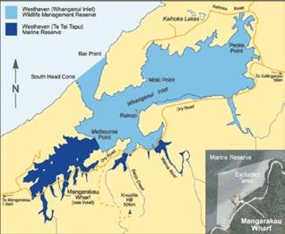
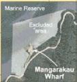
16 MARINE RESERVES It is illegal to take any plant, animal or mineral from a marine reserve or to have marine life or rigged fishing tackle aboard your boat. For more information on marine reserves, see or visit a local Department of Conservation (DOC) office. Tonga Island Marine Reserve (Abel Tasman National Park) Tonga Island Marine Reserve covers an area of 1835 hectares, extending one nautical mile (1852 metres) offshore from the mean high water mark of Tonga Island, and the coast between Awaroa Head and the headland separating Bark Bay and Mosquito Bay. Westhaven Te Tai Tapu Marine Reserve & Westhaven (Whanganui Inlet) Wildlife Management Reserve (Golden Bay) The marine reserve covers 536 hectares and includes all the tidal sandflats and channels south of a straight line between Melbourne Point (Pah Point) and the closest headland of Westhaven Scenic Reserve. It also includes all the tidal areas upstream of causeways along Dry Road, southwest of and including the Wairoa River. An area around the Mangarakau wharf is not included in either reserve. 16
17 17
18 SUMMER 2017/2018 NEWS Navigation safety bylaw All water users are reminded to check the 2015 Navigation Safety Bylaw to remain up to date with the local rules that are likely to affect your boating, please go to www. tasman.govt.nz and search Navigation Bylaw. Users of Nelson waters should note that their bylaw was adopted in December Read more at Local knowledge Tasman area rules and other regional boating information can be found at This includes details of local buoys and beacons and specific advice for navigating into the regions ports and wharves. Low tide aerial pictures of the channels leading into Mapua and Port Motueka are recent additions to this website (Port Nelsons website is No excuses days: Maritime New Zealand and harbourmasters throughout New Zealand will again be re-running the No Excuses program where enforcement takes the place of education and for 5 random days over the summer season instant fines will be issued for breaches of maritime laws. This year both near shore boat speed and lifejacket carrying will be particularly targeted. Ski tube restrictions Fatalities and injuries have been caused as a result of boats towing multiple ski biscuits. The Tasman Harbourmaster recommends that vessels are to tow only one device and a maximum of 3 people. Alert flags for towing vessels Orange flags will be available from the harbourmaster for boats involved in towing. If somebody falls off a ski tube or water skis, the on-board observer is then to wave the flag to alert nearby boaties to look out for a person in the water. Navigation lights Boaties are reminded that it is a legal requirement to display Navigation lights during the hours of darkness. This includes an all-round white light when anchoring. Inflatable swimming pool toys The harbourmaster has noticed an increasing trend for inflatable swimming pool toys to be used in the regions lakes, rivers and the sea. These toys are not robust enough to be used in this way and this practice is not recommended. Users are reminded that lifejackets must be worn if these inflatable swimming pool toys are to be used in the regions waterways. Also be aware that these toys will be very quickly swept away in strong currents or an off shore breeze. Propeller safety Near shore boating and swimming are conflicting activities and all boaties are reminded to keep a very through lookout for swimmers, be particularly vigilant for persons in the water when boats are being launched or retrieved, and when manoeuvring in tidal currents. Anchoring During last summer several boats washed ashore when they dragged anchor, ensure that you have the correct anchor type, Manson Supreme, Rocker and CQR type anchors work well along the predominantly sandy Abel Tasman coastline, also ensure that you have adequate chain length, check your anchor warp for damage and always check the Marine Forecast, Northerly and Easterly winds (onshore) often cause 18
19 problems for boaties. Also remember that Tasman has one of the largest tidal ranges in the country so allow extra anchor line to compensate. Beware nosing into beaches in trailer boats, it is usually safer to anchor off and reverse into the beach to avoid swamping. Carrying a second sand anchor for a sternline is also advised Navigation Several boats also hit submerged rocks last summer, check your charts and understand what the Navigation markers mean (see pg 23 of this brochure). Marine farms Keep up to date with changes to Tasman and Golden Bay marine farm locations and extensions by checking on the Council s web site; recreation/boating-fishing/marine-farms/ or and also with LINZ Notices to Mariners Port Motueka For details on how use the local knowledge channel guide to Port Motueka go to; printed copies can also be picked up from the Motueka Power Boat Club launching ramp. Tides at secondary ports For details go to LINZ website or the NZ Nautical Almanac. As a guideline, tides at Motueka, Kaiteriteri, Tarakohe and Collingwood occur at much the same time as Nelson. Mapua high tides vary significantly depending on tide height, between about 15 and 70 minutes after Nelson times. Tides in the Astrolabe Roadstead are about 20 minutes before Nelson. Tides at the Westhaven Bar (Whanganui Inlet) occur 65 minutes before Westport. This remote bar should not be attempted without recent local knowledge and a suitably equipped and experienced party of vessels, in favourable weather. Waterskiing kaiteriteri Access and congestion continue to be an issue around the Kaiteriteri lagoon entrance, hence water skiing restrictions have been formalised in the 2015 Bylaw. Abel Tasman Foreshore Scenic Reserve management plan This joint DOC / Tasman District Council management plan for the strip of intertidal foreshore between Marahau and Wainui Bay and the nearby islands came into force in June 2012, and will be progressively Implemented over the coming years.you can read or download the plan by searching for it at or at any local Tasman District Council or DOC office. Aid to navigation changes Details of buoys and beacons, and specific advice for navigating near ports and wharves are available on the Tasman District Council website. Details for each area above are at Please make sure your charts are up to date. Events Many fun maritime events are run in the Tasman district each year, these range from high speed power boating and waka races to fireworks displays, for details on these events visit 19
20 SUMMER 2017/2018 TIDE TABLES November 2017 Nelson Low Tides High Tides Date am m pm m am m pm m 1 Wed 2 Thu 3 Fri 4 Sat 5 Sun 6 Mon 7 Tue 8 Wed 9 Thu 10 Fri 11 Sat 12 Sun 13 Mon 14 Tue 15 Wed 16 Thu 17 Fri 18 Sat 19 Sun 20 Mon 21 Tue 22 Wed 23 Thu 24 Fri 25 Sat 26 Sun 27 Mon 28 Tue 29 Wed 30 Thu 1: : : : : : : : : : : : : : : : : : : : : : : : : : : : : : : : : : : : : : : : : : : : : : : : : : : : : : : : : : : : : : : : : : : : : : : : : : : : : : : : : : : : : : : : : : : : : : : : : : : : : : : : : : : : : : : : : : : : Tides based on Nelson. Not for navigational purposes. December 2017 Tide predictions are corrected for NZ Daylight Savings time. Nelson Low Tides High Tides Date am m pm m am m pm m 1 Fri 2 Sat 3 Sun 4 Mon 5 Tue 6 Wed 7 Thu 8 Fri 9 Sat 10 Sun 11 Mon 12 Tue 13 Wed 14 Thu 15 Fri 16 Sat 17 Sun 18 Mon 19 Tue 20 Wed 21 Thu 22 Fri 23 Sat 24 Sun 25 Mon 26 Tue 27 Wed 28 Thu 29 Fri 30 Sat 31 Sun 1: : : : : : : : : : : : : : : : : : : : : : : : : : : : : : : : : : : : : : : : : : : : : : : : : : : : : : : : : : : : : : : : : : : : : : : : : : : : : : : : : : : : : : : : : : : : : : : : : : : : : : : : : : : : : : : : : : : : : : : : Tides based on Nelson. Not for navigational purposes. 20
21 January 2018 Nelson Low Tides High Tides Date am m pm m am m pm m 1 Mon 2 Tue 3 Wed 4 Thu 5 Fri 6 Sat 7 Sun 8 Mon 9 Tue 10 Wed 11 Thu 12 Fri 13 Sat 14 Sun 15 Mon 16 Tue 17 Wed 18 Thu 19 Fri 20 Sat 21 Sun 22 Mon 23 Tue 24 Wed 25 Thu 26 Fri 27 Sat 28 Sun 29 Mon 30 Tue 31 Wed 3: : : : : : : : : : : : : : : : : : : : : : : : : : : : : : : : : : : : : : : : : : : : : : : : : : : : : : : : : : : : : : : : : : : : : : : : : : : : : : : : : : : : : : : : : : : : : : : : : : : : : : : : : : : : : : : : : : : : : : : : Tides based on Nelson. Not for navigational purposes. February 2018 Nelson Low Tides High Tides Date am m pm m am m pm m 1 Thu 2 Fri 3 Sat 4 Sun 5 Mon 6 Tue 7 Wed 8 Thu 9 Fri 10 Sat 11 Sun 12 Mon 13 Tue 14 Wed 15 Thu 16 Fri 17 Sat 18 Sun 19 Mon 20 Tue 21 Wed 22 Thu 23 Fri 24 Sat 25 Sun 26 Mon 27 Tue 28 Wed 5: : : : : : : : : : : : : : : : : : : : : : : : : : : : : : : : : : : : : : : : : : : : : : : : : : : : : : : : : : : : : : : : : : : : : : : : : : : : : : : : : : : : : : : : : : : : : : : : : : : : : : : : : : : : Tides based on Nelson. Not for navigational purposes. 21
22 April 2018 Nelson Low Tides High Tides Date am m pm m am m pm m 1 Sun 2 Mon 3 Tue 4 Wed 5 Thu 6 Fri 7 Sat 8 Sun 9 Mon 10 Tue 11 Wed 12 Thu 13 Fri 14 Sat 15 Sun 16 Mon 17 Tue 18 Wed 19 Thu 20 Fri 21 Sat 22 Sun 23 Mon 24 Tue 25 Wed 26 Thu 27 Fri 28 Sat 29 Sun 30 Mon March 2018 Nelson Low Tides High Tides Date am m pm m am m pm m 1 Thu 2 Fri 3 Sat 4 Sun 5 Mon 6 Tue 7 Wed 8 Thu 9 Fri 10 Sat 11 Sun 12 Mon 13 Tue 14 Wed 15 Thu 16 Fri 17 Sat 18 Sun 19 Mon 20 Tue 21 Wed 22 Thu 23 Fri 24 Sat 25 Sun 26 Mon 27 Tue 28 Wed 29 Thu 30 Fri 31 Sat 3: : : : : : : : : : : : : : : : : : : : : : : : : : : : : : : : : : : : : : : : : : : : : : : : : : : : : : : : : : : : : : : : : : : : : : : : : : : : : : : : : : : : : : : : : : : : : : : : : : : : : : : : : : : : : : : : : : : : : : : : Tides based on Nelson. Not for navigational purposes. 4: : : : : : : : : : : : : : : : : : : : : : : : : : : : : : : : : : : : : : : : : : : : : : : : : : : : : : : : : : : : : : : : : : : : : : : : : : : : : : : : : : : : : : : : : : : : : : : : : : : : : : : : : : : : : : : : : : : : Tides based on Nelson. Not for navigational purposes. 22
23 MARINE FARMS A number of areas of water around Tasman and Golden Bay are set aside for marine farming. These areas, known as AMAs, are shown on the map on pages 2 and 3 of this brochure. Some farms are permanent, some move around seasonally, and some are not yet developed. The boundaries of areas in use for marine farming are marked by cardinal and/or special marks according to the conditions of the farm s permits. These marks are lit at night, and most also have radar reflectors. A plan of the locations of aquaculture aids to navigation is available for download from Note that it is illegal to discharge sewage within 500 metres of a farm, and to interfere with or moor a vessel to any aid to navigation without the owner s written permission. Boaties are discouraged from navigating through these farmed areas. If you do, beware of floating and sub-surface lines and structures. If you damage farm equipment or wish to report a faulty or absent navigation aid, please contact the Harbourmaster. Cardinal marks indicate the safe side on which to pass a danger. They should be passed on the named side (i.e. pass north of a north cardinal mark). All cardinal marks carry a white light and the light flashing sequence designates which side to pass: W NW N NE E North continuous quick flashing East 3 quick flashes South 6 quick flashes + 1 long flash. West 9 quick flashes It is easy to remember the sequence if associated with a clock face. SW S SE MARINE FORECASTS VHF radio the Maritime New Zealand maritime radio service provides forecasts announced on Channel 16 call at 0533, 0733, 1333, 1733 and 2133 hours MetPhone dial map area number (03) Continuous Coastguard Nowcast on VHF channel 79 [New Zealand s national meteorological service] Nelson Marine Radio on VHF channel 28 on National Radio at 5.00 am Sea area Abel applies to Tasman Bay. Sea area Stephens is usually more applicable to Golden Bay and Farewell Spit. Sea area Grey applies to the western side of Farewell Spit. For day trips, you can check current conditions at Lake Rotoiti, Pohara (Tarakohe), Farewell Spit, Rabbit Island, Kaiteriteri and Awaroa by searching for webcams at 23
24 USEFUL CONTACTS EPIRBs Freephone Emergency Position Indicating Radio Beacons (EPIRBs) are distress beacons designed for maritime environments. They are waterproof and designed to float upright in water. Registration of your contact and vessel details is free online and greatly enhances the response in an emergency. Coastguard Boating Education Freephone Coastguard Boating Education is New Zealand s leading provider of recreational boating courses, with more than 40 core and specialty programmes available for all levels of knowledge and ability. Maritime New Zealand Freephone Promotes safe recreational boating, regulates maritime activity, investigates accidents and provides educational resources. LINZ Freephone Tidal predictions for many New Zealand locations, and official nautical publications including charts. Water Safety New Zealand Inc Ph Produces a broad range of free brochures, booklets and posters about most aquatic activities and related water safety issues. TASMAN BOATING CLUBS It is highly recommended that individuals join their local boating club, club members have local knowledge and a wealth of experience to pass on. Please contact the Harbourmaster to have your club listed in future editions, or to amend contact details. Collingwood Boat Club: Brendon, Ph Onetahua Waka Ama Club (Golden Bay): Tracey, Ph Mapua Waterski Club: Kurt, Ph Mapua Boat Club Inc: Tim, Ph Ph Mapua Tamaha Sea Scouts: David, Ph Monaco Boat Club: Barry, Ph Motueka Waka Ama Club: Todd, Ph Motueka Peninsula Marine Society Inc: John, Ph Motueka Powerboat Club Inc (Marina): Ph Motueka Yacht and Cruising Club: Trevor, Ph Motueka & Golden Bay Fishermans Association (Commercial): Doug, Ph Nelson Marlborough Branch Jet Boating NZ: Chris, Ph Pohara Boat Club: Ph Rotoiti Power Boat Club Inc: Julian, Ph

25 SPECIAL EVENTS Organisers of special events may request a temporary speed-limit uplifting or reservation of an area by written application to the Harbourmaster. See the Tasman District Council website for upcoming events MARINAS AND MOORINGS Marinas are located at Port Tarakohe and at Motueka (operated by Motueka Power Boat Club and Motueka Peninsula Marine Society). The Mapua Boat Club administers some casual moorings at Mapua. Anchoring (where the anchor is taken with you when you depart) is permitted anywhere except for the prohibited area off Port Tarakohe, or in access lanes, reserved areas or where it may obstruct a wharf, ramp or channel, or otherwise create a hazard. All moorings and coastal structures require a resource consent or other approval under the Coastal Plan from Tasman District Council. For more details about ports, wharves and moorings see either of the following:

26 COLLINGWOOD A system of local knowledge buoys has been put in place to help with channel navigation, these do not appear on LINZ charts Navigation in the Collingwood area requires extra planning as the approaches are over extensive tidal flats that may be extremely shallow. The approaches may also accumulate logs and other flood debris from the Aorere River Boat ramps and Jetties may completely dry out at low tide The 5 knot speed limit applies within 200m of the shore, (a seasonal exemption may apply upriver from the Aorere river training wall (see pg 11) Further details at MAP LEGEND: 26

27 PORT TARAKOHE Availability of berths for casual users varies. Note that anchoring restrictions apply outside of the harbour. Vessels wishing to berth in Tarakohe Harbour are required to contact the Harbour Manager on Ph or or VHF channels 16, 28 or 68 prior to entry to the harbour. This does not include vessels using the trailer boat launching ramp or vessels that have an allotted berth. The 5 knot speed limit applies within 200 metres of the outer moles, including throughout the harbour. Please manoeuvre at no wake speed in the marina. A coin-operated boat wash is provided. A barrier arm restricts access to the boat launching ramp. Annual pass cards may be purchased through Pohara Beach Boat Club Inc. Casual users may use gold coins or a credit card. Further details at MAP LEGEND: 27

28 TATA BEACH Public toilets and boat launching ramps are available at Tata Beach and nearby Tarakohe. There is a waterski access lane here. Swimmers and other users should stay out of the lane when skiing is happening nearby. This area provides waterskiing at all stages of the tide, but is exposed to the effects of north sector winds, including the sea breeze. All vessels must be travelling at less than 5 knots shoreward of the yellow buoys, including between and shoreward of the Tata Islands. Be vigilant for swimmers and give them plenty of room. The free boat ramp at Tata Beach is exposed to the northwest and sometimes unsafe to use, especially on summer afternoons. An alternative (fee applies) ramp is at nearby Tarakohe Harbour. NOTE: Dogs are prohibited from Tata Beach during daylight savings and for the rest of the year for the hour before and the hour after dawn. MAP LEGEND: Dogs are prohibited from Tata Beach during daylight savings and for the rest of the year for the hour before and the hour after dawn. 28

29 TOTARANUI DOC toilets and two boat launching ramps are nearby. This area provides waterskiing at all stages of the tide, but is exposed to the effects of the sea breeze and southerly sector winds. There is a waterski access lane here. Swimmers and other users should stay out of the lane when skiing is happening nearby. All vessels must be travelling at less than 5 knots shoreward of the yellow buoys. Be vigilant for swimmers and give them plenty of room. WARNING: The channel to the boat ramp in the inlet is a popular swimming location for children. 5 knots maximum speed and extreme caution is required. The beachfront ramp becomes dangerous in strong easterly winds, and vessels may have to stand off shore until the tide allows use of the inlet boat ramp. WARNING: The Totaranui, Awaroa and Mutton Cove beaches have the highest rates of vessel swampings and capsizes in the District. Anchor with care. Only nose into the beach in calm conditions. MAP LEGEND: Dogs are prohibited in the National Park. 29


30 TORRENT BAY Toilets are near the lagoon jetty at the southern end of the beach. Waterskiing is only permitted in this area one hour either side of Port Nelson high tide each day. This is a waterski reserved area. Swimmers, kayakers or other vessels not immediately involved in waterskiing must keep out of the area when it is in use for waterskiing. Please do not trespass on private property. This beach dries extensively at low tide. Beware of being stranded. MAP LEGEND: Note: Dogs are prohibited in the nearby National Park. 30

31 THE ANCHORAGE Toilets are in the nearby DOC camp and at Torrent Bay. There is a waterski reserved area, although it can be used to access the greater Torrent Bay area to the northeast. This area provides waterskiing at all stages of the tide, but is exposed to the effects of northerly sector winds including the sea breeze. A three-knot Go slow zone is 100 metres to the east of this waterski area. Please take care that your wake does not affect moored or anchored boats. An Access Point Transit Lane has been put in place for the area shown in red above, maximum speed is 5 knots, please minimise wake as this lane is adjacent to the designated anchoring area. Yachties are reminded that lifejackets must be carried when using tenders. MAP LEGEND: Note: Dogs are prohibited in the National Park. 31

32 STILWELL BAY DOC toilets are nearby. There is a waterski access lane here. Swimmers and other users should stay out of the lane when skiing is happening. The lane provides beach access at all stages of the tide, but is exposed to the effects of the sea breeze and southerly sector winds. Space on the beach becomes restricted or disappears completely on spring high tides. WARNING: Rocks are covered and uncovered by sand movement in this area so the beach and inshore area should be carefully checked before starting to waterski. Do not trespass on private property above the beach. MAP LEGEND: MARAHAU A corridor is marked with yellow buoys from the boat ramp to the low tide mark. This is intended for use by tractors towing boats to and from the water and is not recommended for navigation by boats except at high tide. The larger buoys mark the designated launching points. Take care for scoured holes at these points. Launching vehicle use is at own risk. Waterskiers and kitesurfers in particular are reminded that there is no access lane at Marahau, so any beach starts and landings should be at walking pace (5 knots) until 200m from shore. The speed limit is also 5 knots in Otuwhero Inlet. 32
. It is exposed to the effects of southerly sector winds and stronger northerly sector breezes.")
33 ADELE ISLAND SANDSPIT There are no toilets on Adele Island. The nearest toilets are at Stilwell Bay or Apple Tree Bay. A waterski area is on the south side of the sandspit (which only appears below half tide). It is exposed to the effects of southerly sector winds and stronger northerly sector breezes. Vessels may be anchored or pulled on to the beach on the north side of the sandspit only. A 3 knot No Wake zone is located on the north side of the sandspit. Yachties are reminded that lifejackets must be carried when using tenders. WARNING: Be aware that kayakers may suddenly appear around the end of the sandspit. The area to the east of the ski area contains rocks that cover and uncover with the tide. MAP LEGEND: Note: Dogs are prohibited in the National Park, at Adele Island and from Otuwhero Inlet and the sandspit at Marahau. 33
 and only when marked out with black posts with white bands, a series of black buoys with white stripes may also be in place to mark out the ski area")
34 KAITERITERI BAY The Kaiteriteri ski area is reserved for priority use by water skiers during the four hour period between two hours before high tide, until two hours after high tide (see the tide tables in the centre section of this brochure) and only when marked out with black posts with white bands, a series of black buoys with white stripes may also be in place to mark out the ski area boundaries. The period of marking may extend from about Labour Weekend until around the end of daylight savings the following year. Outside of these times the reserved area status is revoked and the normal rules apply, see pages Water skiing can also take place outside of the reserved area and outside of 200 meters from the coast in Tasman Bay to the east. Public toilets are at the ramp end of the Motor Camp street frontage and at the Tasman District Council reserve at Little Kaiteriteri. Try to avoid launching and retrieving from the Kaiteriteri ramp during spring low tides due to the low ramp angle and surrounding rocks. PWCs (Jetskis) are prohibited from towing waterskiers within the waterski area. PWCs (Jetskis) may not be operated at over 5 knots in Kaiteriteri Bay. Kayaks and swimmers may not use or pass through the waterskiing area when it is in use. Boats may not pass through the swimming area at any time. Vessels may not anchor unattended in either of the access lanes. Use of moorings should be arranged through the Kaiteriteri Beach Camp office. WARNING: Rotation direction in Kaiteriteri is anti-clockwise for waterskiing to meet national standards. Beware of swimmers caught in the tidal current from the estuary during ebb tides. Swimmers should note the advice in the swimming section of this pamphlet. MAP LEGEND: NOTE: Dogs are prohibited on the main beach at Kaiteriteri and, in the summer months, on Little Kaiteriteri beach except between 5.00 am and 9.00 am. 34

35 MOTUEKA 3 knot speed limit applies in the immediate area of the marina and launch ramp. You are advised that this is intended to effectively mean no wake. This is because many moored craft settle on the bottom near low tide, and wake may cause damage to these vessels, or harm to their occupants. Maximum speed within the transit lane is 15 knots (over ground), the transit lane begins when outbound (and ends when inbound) at the starboard lateral pile closest to the Motueka Wharf. (as marked with a 5 knot sign). The location and shape of the outer bar and sandspit area changes frequently, a local knowledge guide that describes the bouyage system in place can be picked up from the Motueka boat ramp or viewed on the Tasman District Council website, (please be aware that due to the mobile nature of the Motueka sandbank no liability is assumed for this guidance). Seek further local knowledge before crossing to or from the sea. Lifejackets must be worn by law when crossing the bar. Navigation detail and advice for the Motueka to Riwaka area is at Note: Regular users are encouraged to join a local club for ramp access. Casual users of the Motueka Power Boat Club marina ramp should contact the Talleys gatehouse for a temporary card. The ramp fee here is $10, and a $20 card bond is payable (fees subject to change). MAP LEGEND: Note: Dogs are prohibited on much of the sandspit and around the salt water baths. 35

36 KINA PENINSULA There is a waterski reserved area, but coastal access to the estuary may be undertaken in this area by transiting vessels so long as they do not obstruct or endanger any waterskiers. This popular area only provides sufficient water for waterskiing 2 or 3 hours either side of high tide, but is sheltered from most breezes. WARNING: Local knowledge of the position and depth of sand bars and mud banks is essential. Much of the seabed in this area is rock or cobbles. Exercise due caution. Access to the inlet in small craft is possible from the sea. The channel is very narrow and indirect, so obtaining local knowledge (such as a scouting visit from shore at low tide) is recommended. Beware of changing sea conditions that may prevent safe retrieval to your trailer. An afternoon sea breeze can be expected on most summer days. MAP LEGEND: 36
37 MAPUA Beware strong currents and poor anchor holding in channel. No anchoring, fishing or waterskiing in the transit lane. Maximum speed within the transit lane is 15 knots (over ground), outside of the lane 5 knots. Swimmers and kayakers may not enter the transit lane when it is in use. Keep to the starboard (right hand) side. Access to the sealed ramp at the Mapua Wharf is now restricted. It is recommended that launching is done from the unsealed launching area at Grossi Point (the floating pontoon at the Mapua Wharf is a good place to pick up passengers and supplies once vessels are on the water). All vessels must keep speed below 5 knots until they reach the transit lane or Hunter Brown waterski area. Take care for pacific oysters in this area. They have very sharp shells. The location and shape of the outer bar and sandspit area changes frequently. Seek local knowledge before crossing to or from the sea. Lifejackets must be worn by law when crossing the bar. WARNING: Swimmers at Grossi Point should stay clear of boats, as the shallow bed and current can make it difficult for vessels to manoeuvre to avoid you. Note: No overnight mooring at floating pontoon jetty Maximum vessel length for pontoon is 10 metres Kayakers are advised to avoid the floating pontoon as strong tidal currents can sweep small boats underneath the pontoon. Children need to be supervised around the wharf area. HUNTER BROWN This area is easily accessed from the boat launching ramps at Hunter Brown (Rough Island; adjacent to Rabbit Island), Grossi Point or Mapua Wharf. Note that the usual 5 knot speed limit applies between the Grossi Point ramp and the ski area. Toilets are available near all these launch ramps. This waterski area only provides sufficient water for waterskiing 2 or 3 hours either side of high tide, but is sheltered from most breezes. Rotation direction is anti clockwise, that is keep to the starboard (right hand) side approaching and leaving the beach. WARNING: Local knowledge of the position and depth of sand bars and mud banks is essential, particularly in the extension into the Traverse. Check the area of the beach that you will be taking off and landing from for pacific oysters. Pacific oysters have very sharp shells and may inflict severe cuts if stood on in bare feet or light footwear. NOTE: See map pages 38 & 39 for Mapua and Hunter Brown. 37
38 e : ¾eÙ Û ¾eÙ I8 É9É0 ÉÞ Mapua Channel: Transit Lane Maximum Speed 15 Knots, Water Skiing Prohibited ³Ù ³ ³Ù ³ Hunter Brown: Water Skiing Area #*! Rough Island I m TRAVERSE This area can be accessed in shallow draft vessels at high tide, with care, from Hunter Brown. Note that this is a shared PWC (jetski) and waterskiing area. Co-operation between users is essential to the continued availability of this area. This area is very shallow and should be thoroughly checked for branches and other obstacles before use. Local knowledge is essential. The slalom course is maintained by the Mapua Waterski club. Members of the Club have launching access at the Rabbit Island causeway. Note: Dogs are prohibited on Rabbit Island but may be exercised off the leash at Rough Island. 38

 G 6s 3m")


39 Mapua MAP LEGEND: Water skiing direction of rotation Infrastructure corridor - no anchoring Waterski landing marker RICHMOND Starboard lateral FI (2) G 6s 3m 2NM Port lateral FI R 3m 2NM Fairway buoy FI G 1.3m 3NM Port lateral buoy (shoaling area) Boat launching ramp Food / drink Rabbit Island Jetty Petrol Water Former causeway - Very shallow The Traverse: Water Skiing & PWC Area Caution - swing moorings Transit lane for Mapua channel Shared high speed activity area Water skiing area Look after your family, look after yourself For safety tips and info go to or NOTE: See page 40 for Rabbit Island ski and PWC area map. 39
 area which is adjacent to the launch ramp. Please transit directly through this area and avoid PWCs that may be using the area.")
40 RABBIT ISLAND A toilet is available near the launch ramp. The large waterskiing area is easily accessed from the boat launching ramp at Rabbit Island, or from Monaco with local knowledge. Vessels using the ski area must pass through the PWC (Jet Ski) area which is adjacent to the launch ramp. Please transit directly through this area and avoid PWCs that may be using the area. This area only provides sufficient water for waterskiing 2 or 3 hours either side of high tide, but is sheltered from most breezes. The waterski area can be used to access the estuary to the east when there is sufficient water. A suitable beach start area is marked with posts on the shore of Rabbit Island near the Blind Channel end. *Kitesurfers are asked to avoid the eastern half of the front beach as kite shadow can spook horses. MAP LEGEND: 40

41 ST ARNAUD - LAKE ROTOITI Toilets are located at each end of the beach and there is another boat ramp and toilet at West Bay. The waterski access lane is intended only to provide access at speed to the beach for boats immediately involved in waterskiing. Beach starts for waterskiing are only allowed in the access lane or the water Ski area. Do not ski from other beaches on this lake. Deep water starts over 200m from shore are permitted anywhere on the lake. The water ski area (West Bay as shown on map) is available for year round use and is marked with transit posts. To contact the water taxi, call on VHF channel 14 or Ph At Lake Rotoroa, call on VHF channel 6 or Ph PWCs (Jetskis) are prohibited from operating on Lake Rotoiti or Lake Rotoroa by Department of Conservation Bylaw or Regulations. Note: All vessels must not exceed 5 knots shorewards of the line between the two orange triangles on either side of Kerr Bay. Vessels must also stay out of the area reserved for swimming in the middle of the main beach, as marked with black and white buoys during peak season. WARNING: The West Bay boat ramp is not recommended for tandem trailers or heavy craft due to steep ramp angle. Beware of rocks near West Bay jetty when lake level is low. MAP LEGEND: NOTE: Dogs are prohibited in the National Park, including on the lakes. 41
42 42


43 Going boating? Rodents have been found on the Abel Tasman National Park s previously predator-free Adele, Tonga and Fisherman Islands. Ongoing predator control is underway but we need your help. If landing at Adele or Fisherman Island or mooring near any of the islands, please check boats and gear are free of rats, mice, ants, seeds and weeds. Help keep these islands safe for native wildlife. For more information please visit 7 mm Size of gap a mouse can squeeze through. South Island robin toutouwai South Island saddleback tīeke 12 mm Size of gap a rat can squeeze through. Abel Tasman National Park Virtual Visitor Centre available free on your smartphone Includes up-to-date information on weather, tides, walking times, track conditions, map, points of interest, history, plants and wildlife. Search for Abel Tasman National Park. The app and private Wi-Fi network are provided by Project Janszoon, a private trust working in partnership with the Department of Conservation to restore the ecology of the park. works works off-line off-line 43
Boating and water sports
 FREE! Boating and water sports in Tasman District 2018 / 2019 For more information visit: www.tasman.govt.nz/recreation/boating-fishing or scan this QR code with your smartphone > Puponga Whanganui Inlet
Nagambie Waterways Boating Guide 2007
 Nagambie Waterways Boating Guide 2007 Welcome Strathbogie Shire Council has prepared the Nagambie Waterways Boating Guide to help boaters safely enjoy this recreation venue. Funding to assist with the
Chapter 5 Personal Watercraft Jet Skis and High Speed Power Boats
 Chapter 5 Personal Watercraft Jet Skis and High Speed Power Boats 69 5 Personal Watercraft (PWC) such as jet skis or water/wet bikes are a rapidly growing segment of the recreational craft market. A PWC
The event or activity may only occur if it is carried out in accordance with: 1. information in the application provided; and
 File: H271 Writer s Direct Dial No. (03) 543 8433 E-mail: harbourmaster@tasman.govt.nz Dave Craig 48 Oak Crescent Ashurst 4810 Dear Dave NAVIGATION SAFETY BYLAW 1 : TEMPORARY RESERVATION AT TORRENT BAY
Provisions for Moorings
 Provisions for Moorings Tasman Resource Management Plan Summary Guide No. 11 Current: July 2013 1. Introduction Structures and occupation of the coastal marine area (CMA) are managed to control the location
Demonstrate basic knowledge of the operation of pleasure/small craft by day
 Page 1 of 7 Title Demonstrate basic knowledge of the operation of pleasure/small craft by day Level 2 Credits 6 Purpose This unit standard is for pleasure craft operators and covers knowledge required
2018 First National Nelson Regatta
 2018 First National Nelson Regatta Keelboat Rally & Regatta Sunday 21 st Wednesday 24 th January 2018 Sailing Instructions The Organising Authority is the Tasman Bay Cruising Club Inc. (TBCC) PO Box 5062,
SAFER BOATING GUIDE PREP YOUR BOAT CHECK YOUR GEAR KNOW THE RULES
 SAFER BOATING GUIDE PREP YOUR BOAT CHECK YOUR GEAR KNOW THE RULES 1 BOATING SAFETY CODE WEAR YOUR LIFEJACKET TAKE TWO WATERPROOF WAYS TO CALL FOR HELP NEARLY HALF OF ALL KIWIS GO BOATING New Zealand is
MCA Guidance for Pleasure Vessels. A brief guide to regulation and safe practice
 MCA Guidance for Pleasure Vessels A brief guide to regulation and safe practice MCA Guidance Around three million people enjoy going afloat in the UK every year. Although pleasure boating in the UK is
Boating Tip #47: Safety Gear & Required Equipment
 Boating Tip #47: Safety Gear & Required Equipment The U.S. Coat Guard requires that recreational vessels carry specific safety equipment while underway. The safety gear must be in good condition and readily
Incident Report. Close Quarters Pegasus II & Distraction. 26 April 2006 Class B
 Incident Report Close Quarters Pegasus II & Distraction 26 April 2006 Class B NARRATIVE Pegasus II (See Photograph 1 Pegasus II) is a 15.46 metre commercial fishing vessel with a gross tonnage of 40. She
NAUTICAL TERMINOLOGY
 It s important to have a basic understanding of common nautical terms associated with the parts, positions and directions of your vessel. Knowing these terms will make it easier to communicate with people
1.3 INTRODUCTION 1.4 OBJECTS OF ASSOCIATION 1.5 DEFINITIONS
 PREAMBLE 1.3 INTRODUCTION Sea Kayak Club WA Inc. provides and coordinates a variety of recreational sea kayaking activities for its members with emphasis on safety and minimization of the hazards and risks
Berkeley Island Marine Pre-Rental Instructions. If you do not have a
 Berkeley Island Marine Pre-Rental Instructions. If you do not have a safe boating certificate or a boat license in the state of NJ, or an equivalent in another state, you must take this instruction. Approximate
Nanaimo Ocean Swim and Newcastle SUP Race Safety Plan
 Nanaimo Ocean Swim and Newcastle SUP Race Safety Plan Use of this document Permission is granted to reproduce any information in this document; however, please notify the author (Matthew Lamb) if doing
Hawke s Bay Navigation Safety Bylaw Review Draft
 1 Hawke s Bay Navigation Safety Bylaw 2017 Review Draft Chapters 1.0 1.4 Preliminary Provisions, including purpose, and definition of terms 2.0 2.17 General Matters including lifejackets, identification
Instructions for Support Boat Duties
 Instructions for Support Boat Duties You must attend the Race day and safety briefing in the committee room ( usually at 8.45am) You should bring your own lifejacket with you as the club does not have
Sweep Training January 2017
 Sweep Training January 2017 Sweep Accreditation Training Sweep accreditation is an NZDBA initiative designed to ensure that participants in NZDBA events are afforded the safety benefits of a trained sweep.
SUB Vessel Safety Check Review D11NR VE s-we save lives! Prepared by: Mike Lauro DSO-VE 11NR and Tony Budlong ADSO-VE 11NR
 SUB Vessel Safety Check Review D11NR VE s-we save lives! Prepared by: Mike Lauro DSO-VE 11NR and Tony Budlong ADSO-VE 11NR Sport Utility Boats (SUB) The fastest growing area of Recreational Boating! What
Royal Temple Yacht Club Notice of Race & Sailing Instructions 2019
 Royal Temple Yacht Club Notice of Race & Sailing Instructions 2019 The organising authority for each day of racing will be The Royal Temple Yacht Club Notice of Race for IRC and Cruiser Handicap classes
Using a RIB for a Safety Boat Duty
 Using a RIB for a Safety Boat Duty Reminder Notes for Safety Boat Helms This information should be used as a reminder of what constitutes safe practice when carrying out a safety boat duty. However, the
Visiting Lake Macquarie
 Visiting Lake Macquarie Lake Macquarie is the largest coastal salt water lake in Australia and is a prime boating destination for both small and large vessels. Many sailing regattas and fishing activities
Melanoma Ski-nZ 2018 Sunday 25 th February to 3 rd March 2018
 EVENT GUIDE Melanoma Ski-nZ 2018 Sunday 25 th February to 3 rd March 2018 Melanoma Ski-nZ is a fun-filled adrenalin packed adventure on personal water craft (PWC). Ski-nZ is staged by Melanoma New Zealand
Assessors Name: East Coast OGA Sub Committee Date: 28 April 2015 Persons Affected: Skipper & Crew. Quantifying Risks
 Risk Assessment: EAST COAST RACE EVENT 2015 Risk Assessments of: East Coast Race Event 17 th 19 th July 2015. Man Overboard, Physical Injury or Illness, Sea Sickness, Fire, Gear Failure, Grounding or Shipwreck,
LORD HOWE ISLAND. INFORMATION FOR YACHTS & SMALL CRAFT VISITING LORD HOWE ISLAND WORLD HERITAGE AREA and LORD HOWE ISLAND MARINE PARK
 LORD HOWE ISLAND INFORMATION FOR YACHTS & SMALL CRAFT VISITING LORD HOWE ISLAND WORLD HERITAGE AREA and LORD HOWE ISLAND MARINE PARK Masters of yachts & small craft are advised to contact the Lord Howe
Instructions for Support Boat Duties
 Instructions for Support Boat Duties You must attend the Race day and safety briefing in the committee room (usually at 8.30am) You should bring your own lifejacket with you as the club does not have any
Chapter 7 Canoeing/Kayaking
 Chapter 7 83 84 Canoeing covers a wide and diverse range of disciplines including sea kayaking, white water kayaking, surf kayaking, polo, slalom, marathon, sprint, freestyle and touring. A canoe is a
When answering a question, when in doubt, pick answer that considers safety first. Navigation Aids
 Appendix A Boat Course Review When answering a question, when in doubt, pick answer that considers safety first. Navigation Aids Port hand lateral buoy Starboard hand lateral buoy (red right returning)
2017 CNI SECONDARY SCHOOLS TEAM SAILING REGATTA Safety Plan SAFETY ACTION PLAN
 SAFETY ACTION PLAN Event: 2017 CENTRAL NORTH ISLAND SECONDARY SCHOOLS TEAM SAILING REGATTA Date: Sunday 26th to Tuesday 28th March 2017 Event Manager: Anthony Byett Phone Number: 021 209 6733 Participants
2002 National Recreational Boating Survey Technical Report
 2002 Technical Report November 30, 2003 995 Goodale Blvd. Columbus, OH 43212 Voice: (614) 220-8860 Fax: (614) 220-8845 Toll Free Number: (800) 341-3660 Website: www.strategicresearchgroup.com TABLE OF
Harbourmaster s Office Tamaki River. Navigation Safety Operating Requirements 2014
 Harbourmaster s Office Tamaki River Navigation Safety Operating Requirements 2014 Auckland Council Harbourmaster s Office TAMAKI RIVER Navigation Safety Operating Requirements FOREWARD The purpose of these
HEALTH & SAFETY PLAN. A1 Homes One Base 2017 FISHING TOURNAMENT
 HEALTH & SAFET PLAN For: A1 Homes One Base 2017 FISHING TOURNAMENT Based on NZ Sport Fishing Council Health & Safety Plan, and used by permission. Modified to meet One Base Tournament and local conditions
10TH AND 11TH MARCH 2018
 10TH AND 11TH MARCH 2018 Remember to display your entry tag. It must be on your photo entry with your fish to collect any prize or lucky draws etc. No exceptions. Fees must be paid up and cleared prior
Pleasure Boat Inspection
 in cooperation with SBA Pleasure Boat Inspection A complete guide to a successful preparation This publication contains all necessary information related to pleasure boat inspection and is a valuable 258
WELCOME TO THE. Pleasure Craft Operator Training (PCOC)
") WELCOME TO THE Pleasure Craft Operator Training (PCOC) REGULATIONS The Competency of Operators of Pleasure Craft Regulations require operators of pleasure craft fitted with a motor and used for recreational
WELCOME TO THE Pleasure Craft Operator Training (PCOC) REGULATIONS The Competency of Operators of Pleasure Craft Regulations require operators of pleasure craft fitted with a motor and used for recreational
Scope: This is the minimum required standard that applies to all basic boating courses in the U.S. states and territories and District of Columbia.
 Title: Level 1 Basic Boating Knowledge Scope: This is the minimum required standard that applies to all basic boating courses in the U.S. states and territories and District of Columbia. Purpose: To establish
Paddlesports Safety Facilitator - SUP
 SUP Module Overview: We expect Paddlesports Safety Facilitators (PSF) for the SUP Module to be able to effectively maneuver their board, and demonstrate competent rescue techniques. This certification
Safety Recommendations & Codes of Practice
 Safety Recommendations & Codes of Practice Reviewed 2018 Amended 2018 Introduction Safety is very important when participating in any sport. Safety not only means the safety of those participating in the
Paddle Craft Vessel Safety Check Review D11NR Vessel examiner swe save lives! Prepared by: Mike Lauro DSO-VE 11NR
 1. Paddle Craft Vessel Safety Check Review D11NR Vessel examiner swe save lives! Prepared by: Mike Lauro DSO-VE 11NR Paddle Craft The fastest growing area of Recreational Boating! What s a Paddle Craft?
Abel Tasman National Park
 Otago Trailer Yacht Squadron OTYS - PO Box 5393 Moray Place, Dunedin OTAGO TRAILER YACHT SQUADRON CRUISING GUIDES & ARTICLES COLLECTION Abel Tasman National Park Author unknown. First published 1984. A
National Maritime Center
 National Maritime Center Providing Credentials to Mariners Q301 Rules of the Road-Inland (Sample Examination) Page 1 of 19 Choose the best answer to the following Multiple Choice Questions. NO reference
Essential Safety. in Chichester Harbour. An essential guide for the new or less experienced mariner
 Essential Safety in Chichester Harbour An essential guide for the new or less experienced mariner 01243 512301 www.conservancy.co.uk 1 Enjoying Chichester Harbour in safety Chichester Harbour is renowned
Boating safety checklist. A guide to lifejacket and safety equipment rules on NSW waters
 Boating safety checklist A guide to lifejacket and safety equipment rules on NSW waters Definitions Master s responsibility The master is responsible for all people on board and can direct passengers to
Maritime Rules Part 91 Navigation Safety Rules
 Maritime Rules Part 91 Navigation Safety Rules ISBN 978-0-947527-28-0 Published by Maritime New Zealand, PO Box 25620, Wellington 6146, New Zealand Maritime New Zealand Copyright 2016 Part 91: Navigation
Gulf Harbour Village Marina Licence of Berth Terms & Conditions
 Gulf Harbour Village Marina Licence of Berth Terms & Conditions DEFINITIONS Agreement means the agreement entered into between the Berth Owner and the Berth Renter, to which these Terms and Conditions
Harbourmaster s Office Operation of Superyacht in the Auckland Region Navigation Safety Operating Requirements
 Harbourmaster s Office Operation of Superyacht in the Auckland Region Navigation Safety Operating Requirements Foreword Maritime Rule 90 requires that every vessel of 500 Gross tonnage or greater carries
2014 Advantage Boating Sail Canada Basic Cruising Standard. Section III: Part B Safety Safety Guidelines and Avoiding Hazards
 Section III: Part B Safety Safety Guidelines and Avoiding Hazards Lesson Outline Lesson Objectives Introduction Navigation lights Distress signals Hazards Radar reflector Summary Quiz 2 Lesson Objectives
Bay of Plenty Regional Navigation Safety Bylaw 2017
 Bay of Plenty Regional Navigation Safety Bylaw 2017 Contents BAY OF PLENTY REGIONAL NAVIGATION SAFETY BYLAW 2017 This Bylaw carries the Common Seal of the Bay of Plenty Regional Council to confirm that
The LA/LB Harbors handle more than 5,500 commercial vessel arrivals per year (excluding local coastwise and Catalina Island traffic).
.") X. SMALL CRAFT For the purpose of the Los Angeles and Long Beach Harbor Safety Plan, pleasure vessels, commercial fishing vessels and sportfishing boats are designated as small craft. A. BACKGROUND: The
X. SMALL CRAFT For the purpose of the Los Angeles and Long Beach Harbor Safety Plan, pleasure vessels, commercial fishing vessels and sportfishing boats are designated as small craft. A. BACKGROUND: The
Astrolabe Reef Access Plan Stakeholder Presentation
 Astrolabe Reef Access Plan Stakeholder Presentation *Rena s bow thruster approx 18m Agenda Overview Access Plan Introduction State of the Reef & Wreck Site What to Expect Timetable & Activity Questions
TIDES & NAVIGATION MARLBOROUGH SOUNDS
 TIDES & NAVIGATION MARLBOROUGH SOUNDS 18-19 Cruise Guide: FREE app for sailing in the Marlborough Sounds Cruise Guide is your in-pocket sailing companion. Explore Marlborough s stunning coastline, discovering
Schedule 1 Safety Equipment & Scrutineering Check List
 Schedule 1 Safety Equipment & Scrutineering Check List BOAT NAME SKIPPER NAME CREW MEMBER NAME We, the undersigned, hereby confirm that we have each physically checked that the safety equipment required
SUB Vessel Safety Check Review. Prepared by: Mike Lauro DSO-VE 11NR and Tony Budlong ADSO-VE 11NR
 SUB Vessel Safety Check Review Prepared by: Mike Lauro DSO-VE 11NR and Tony Budlong ADSO-VE 11NR Sport Utility Boats (SUB) The fastest growing area of Recreational Boating! What s an SUB? Canoe, kayak,
National Maritime Center
 National Maritime Center Providing Credentials to Mariners (Sample Examination) Page 1 of 19 Choose the best answer to the following multiple choice questions. NO reference materials are authorized for
Class B Accident Report. Unnamed Dinghy Swamping
 Class B Accident Report Unnamed Dinghy Swamping At Lake Hood on 3 October 2004 REPORT NO: 04 1135 UNNAMED DINGY SWAMPING At about 1200 hours on 3 October 2004, it was decided to take the Unnamed Dinghy
General Water Safety Tips
 General Wherever there is water these rules apply. Know the Aquacode Go Together, Stay Afloat and Wave, Reach to Rescue. Always swim with a friend or adult. To reach and rescue, lie down and stretch out.
COMBINED OCEAN POINTSCORE SAILING INSTRUCTIONS 2018 / 2019
 COMBINED OCEAN POINTSCORE NEWCASTLE CRUISING YACHT CLUB LAKE MACQUARIE YACHT CLUB SAILING INSTRUCTIONS 2018 / 2019 1 1 RULES 1.1 The event will be governed by the rules as defined in The Racing Rules of
PECANWOOD BOAT CLUB RULES AND REGULATIONS
 PECANWOOD BOAT CLUB RULES AND REGULATIONS The rules and regulations as set out below pertain to the Pecanwood Boat Club (The Club) and the use of the Hartbeespoort Dam (The Dam). Section A pertains specifically
Safe Boating AN ESSENTIAL GUIDE
 Safe Boating AN ESSENTIAL GUIDE www.adventuresmart.org.nz KNOW BEFORE YOU GO The Boating Safety CODE Before you go boating on our seas, lakes and rivers, get familiar with New Zealand s Boating Safety
Hypothermia is the Lowering of the Body Core Temperature
 54 Hypothermia is the Lowering of the Body Core Temperature HEAD NECK GROIN ARM PITS and SIDES OF THE CHEST 55 Helpful positions when immersed in cold water. 56 ALTERNATE RECOVERY METHODS (No Ladder) 57
SAILING INSTRUCTIONS MORETON BAY BOAT CLUB PEARL CHALLENGE 2017
 SAILING INSTRUCTIONS MORETON BAY BOAT CLUB PEARL CHALLENGE 2017 Saturday 17 th June and Sunday 18 th June 2017 Organising Authority Moreton Bay Boat Club Inc. at the Redcliffe Peninsula 1. RULES The event
New Syllabus for 12 Nautical Miles
 New Syllabus for 12 Nautical Miles 1. Legal and professional responsibilities of skippers under the Tourism Authority Act 2006. a) The meaning of Skipper as defined under the Tourism Authority Act 2006
MAYFLOWER OFFSHORE ROWING CLUB
 INTRODUCTION MAYFLOWER OFFSHORE ROWING CLUB SEA SAFETY AND OPERATIONAL PROCEDURES Offshore rowing is an enjoyable and exciting sport. These guidelines are intended to make the sport as safe as possible
Safety & Emergency Plan
 Safety & Emergency Plan For the Management of Racing for all Sailing Dinghy & Board Classes Objective: To provide a safe on-the-water environment for Competitors and Volunteers having regard for both expected
Royal Port Nicholson Yacht Club Cook Strait Classic Race 9 December 2017 Sailing Instructions
 Royal Port Nicholson Yacht Club Cook Strait Classic Race 9 December 2017 Sailing Instructions The Organising Authority is the Royal Port Nicholson Yacht Club Incorporated (RPNYC) 103 Oriental Parade Wellington
WESTHAVEN TRIPLE SERIES SAILING INSTRUCTIONS
 WESTHAVEN TRIPLE SERIES 12 th November 2016 22 nd April 2017 The Organising Authorities are the Royal New Zealand Yacht Squadron (RNZYS) Ponsonby Cruising Club (PCC) & Richmond Yacht Club (RYC) SAILING
General Boating Knowledge. Common Sense before leaving shore
 General Boating Knowledge Common Sense before leaving shore Engines work, battery charged, hull, tires, drain plug, etc Safety equipment example - Life jackets fit correctly for everyone on board Safety
Navigation Safety Bylaw 2014 and Controls Ture ā-rohe Urungi Āhuru 2014
 Navigation Safety Bylaw 2014 and Controls Ture ā-rohe Urungi Āhuru 2014 (as at 31 July 2014) Pursuant to the Maritime Transport Act 1994, the Local Government Act 2002 and the Local Government (Auckland
VESSEL INCIDENT REPORT (Reporting procedures required by NSW Marine Legislation)
") VESSEL INCIDENT REPORT (Reporting procedures required by NSW Marine Legislation) To assist in completing this form, please refer to the Explanatory Notes at the end of this document. For further information
VESSEL INCIDENT REPORT (Reporting procedures required by NSW Marine Legislation) To assist in completing this form, please refer to the Explanatory Notes at the end of this document. For further information
Aids to navigation can include buoys, day beacons, range markers, and lighthouses.
 This boating safety course manual has been approved by Transport Canada strictly on the basis that it meets the minimum requirements of basic boating safety knowledge set out in Transport Canada s Boating
properly applied assessment in the use.1 landmarks.1 approved in-service of ECDIS is not experience The primary method of fixing required for those
 STCW Code Table A-II/3 Specification of minimum standard of for officers in charge of a navigational watch and for masters on ships of less than 500 gross tonnage engaged on near-coastal voyages Ref: https://www.edumaritime.net/stcw-code
RYA MAJOR YOUTH & JUNIOR EVENT SAFETY STANDARD OPERATING POLICY AND PROCEDURES
 RYA MAJOR YOUTH & JUNIOR EVENT SAFETY STANDARD OPERATING POLICY AND PROCEDURES Index: 1. Introduction 2. Objectives 3. Overall organisational structure 4. Radio callsigns 5. Radio procedures 6. Safety
CITY MARINA OPERATING RULES
 CITY MARINA OPERATING RULES January 2017 1. Access to the City Marina a. The City Marina is a facility made available for use by owners and authorised crew of leisure craft (hereinafter referred to as
ADMINISTRATIVE INSTRUCTION No. STCW-14 QUALIFICATION / CERTIFICATION REQUIRED FOR OPERATION OF A DOMESTIC VESSESL
 ADMINISTRATIVE INSTRUCTION No. STCW-14 QUALIFICATION / CERTIFICATION REQUIRED FOR OPERATION OF A DOMESTIC VESSESL (Issued under section 3(5) of the Gibraltar Merchant Shipping (Safety etc.) Ordinance 1993
Marine Operations Manual Section 08. Leisure Zone Management Policy
 Marine Operations Manual Section 08 Leisure Zone Management Policy Document Author: Nick Shearman Contact Details Telephone: 01304 240400 Ext. 4522 E-Mail: Nick.Shearman@doverport.co.uk Document Owner
RISK ASSESSMENT -HEATS-
 Honda RYA Youth RIB Championship 2018 RISK ASSESSMENT -HEATS- Issued by Royal Yachting Association October 2017 Page 1 of 12 Risk Assessment Event Summary Event Honda RYA Youth RIB Championship Organising
SAILING INSTRUCTIONS BILLY RUN. Saturday 28 April The organising authority (OA) is the South of Perth Yacht Club
 is the South of Perth Yacht Club") SAILING INSTRUCTIONS BILLY RUN Saturday 28 April 2018 The organising authority (OA) is the South of Perth Yacht Club 1. RULES 1.1. The regatta will be governed by the rules as defined in The Racing Rules
SAILING INSTRUCTIONS BILLY RUN Saturday 28 April 2018 The organising authority (OA) is the South of Perth Yacht Club 1. RULES 1.1. The regatta will be governed by the rules as defined in The Racing Rules
1. An aid to navigation is any object external to the boat that: 1) helps a boater pilot a boat safely, 2) aids a boater in finding position and 3)
 helps a boater pilot a boat safely, 2) aids a boater in finding position and 3)") 1. An aid to navigation is any object external to the boat that: 1) helps a boater pilot a boat safely, 2) aids a boater in finding position and 3) a. marks the best fishing holes. b. provides a place
1. An aid to navigation is any object external to the boat that: 1) helps a boater pilot a boat safely, 2) aids a boater in finding position and 3) a. marks the best fishing holes. b. provides a place
2018 SERVICES OFFSHORE REGATTA June 2018
 SAILING INSTRUCTIONS 2018 SERVICES OFFSHORE REGATTA 18 23 June 2018 1. The organising authority is the Association of Service Yacht Clubs (ASYC). 2. The primary intent for the 2018 Services Offshore Regatta
How to Operate the MYC Support Boats and Equipment
 How to Operate the MYC Support Boats and Equipment Definitions: 1) MYC Support boats include: Carlyle (Start Boat) Robbie R RIBs- Christabel, Margo, Nigel Holman 2) Boat Licence: A boat licence issued
ELAN YACHTS COMMODORES CUP SERIES
 ELAN YACHTS COMMODORES CUP SERIES 11 th November 2017 7 th April 2018 The Organising Authority is the Royal New Zealand Yacht Squadron 181 Westhaven Drive, Westhaven, Auckland 1011 PO Box 46182 Herne Bay,
Class B Accident Report. West Bay Water Taxi and Kontiki Collision
 Class B Accident Report West Bay Water Taxi and Kontiki Collision Picton Harbour on 14 November 2004 REPORT NO: 04 3602 WEST BAY WATER TAXI AND KONTIKI COLLISION The West Bay water taxi collided with pleasure
Order Adopting Amendments. Title 58. Recreation Part II. Fish and Boat Commission Chapters 97, 109, 111 and 115 Boating. Preamble
 Order Adopting Amendments COMMONWEALTH OF PENNSYLVANIA PENNSYLVANIA FISH AND BOAT COMMISSION Title 58. Recreation Part II. Fish and Boat Commission Chapters 97, 109, 111 and 115 Boating Preamble The Fish
Supplementary Sailing Instructions
 The Yanmar Wooden Boatshop 2018 Wooden Boat Festival of Geelong 10 th 12 th March, 2018 Corio Bay and Port Phillip, Geelong, Australia Supplementary Sailing Instructions Organizing Authority: The Royal
Risk Assessment, Method Statement for:
 Risk Assessment, Method Statement for: 2018 Gillian Saltire Open Water Swim Cumbrae to Largs Completed by: Morag Love & David Ennis Date: 10/06/2018 Approved by: James Gallagher Date: 11/06/2018 Coordination
Advanced Sea Kayak Leader Assessment Notes
 Advanced Sea Kayak Leader Assessment Notes Technical Syllabus Part A - Personal Paddling Skills Through the blending of their body, boat and blade positions, the paddler must be able to skilfully control
Skomer Marine Conservation Zone Byelaws and Codes of Conduct
 Skomer Marine Conservation Zone Byelaws and Codes of Conduct BYELAWS The Marine Conservation Zone (MCZ) byelaws are summarised below. A copy of the MCZ byelaws is available free on request. The MCZ s byelaws
International Learn To Swim Programme Water Safety Questions
 International Learn To Swim Programme Water Safety s s for First Step Series s Poolside Safety & Poolside Rules 1. Where is the shallow end of the The answer is specific to the centre. swimming 2. When
Yachting New Zealand Centreboard Clubs Standard Sailing Instructions
 Yachting New Zealand Centreboard Clubs Standard Sailing Instructions Version 2016 v10 (Effective from 1 st September 2016) http://sites.google.com/site/nzcentreboardstandardsis/ A single copy of these
Boating Activity-Specific Plan
 Boating Activity-Specific Plan Camp Name: Prepared By: Phone number: Signature: Date: Enter a date. Title: Email: Complete the following plan for each boating activity that campers participate in. Use
STEWART 34 CHAMPIONSHIP SERIES
 STEWART 34 CHAMPIONSHIP SERIES The Organising Authority is the Royal New Zealand Yacht Squadron 181 Westhaven Drive, Westhaven, Auckland 1011 in conjunction with the Stewart 34 Owners Association Tel:
St. Abbs Harbour Information Sheet
 St. Abbs Harbour Information Sheet Welcome to St. Abbs Harbour located in one of the United Kingdoms top diving sites; the information contained herewith will hopefully make your visit to the area both
2 Boating Rules and Regulations... 73
 Contents at a Glance Chapter 1 Boat Design and Construction Chapter 2 Boating Rules and Regulations Chapter 3 Navigation Rules (ColRegs) Chapter 4 Boat Operating and Seamanship Chapter 5 Piloting and Navigation
SECTION 11 ADVENTUROUS ACTIVITIES PADDLING: KAYAKING
 SECTION 11 ADVENTUROUS ACTIVITIES 11.18 PADDLING: KAYAKING 11.18.1. ACTIVITY SCOPE This section relates to members participation in Kayaking as a Scouting Activity. A kayak is a small, narrow watercraft
BOATING AND SWIMMING RULES
 BOATING AND SWIMMING RULES Revised by the ALA Board of Directors June 23, 2018 A. GENERAL RULES: 1. All members participating in boating and swimming activities agree to know and follow these rules. Violation
MINISTRY OF TOURISM GUIDELINES FOR KITESURFING ACTIVITIES
 MINISTRY OF TOURISM GUIDELINES FOR KITESURFING ACTIVITIES 1. Purpose of the Guidelines The guidelines aim at ensuring that kitesurfing activities are conducted in compliance with acceptable standards and
DRI Policy for Safety Associated with Measurements, Sampling, and Related Streamgaging. Table of Contents
 Table of Contents Introduction 1 Scope 1 General Policy 1 Responsibilities for Safety Compliance 2 Corrective Action for Failure to Follow Procedures 2 Appendix A General Safety Guidance for Making Measurements
Sailing Instructions. International Dragon Class Edinburgh Cup Friday 29 June - Saturday 7 July Racing Tuesday 3 - Friday 6 July
 International Dragon Class Edinburgh Cup 2018 Friday 29 June - Saturday 7 Racing Tuesday 3 - Friday 6 Royal Torbay Yacht Club Torquay, Devon Sailing Instructions International Dragon Class Edinburgh Cup
A buoy, for example is an aid to navigation. Aids to navigation include many types of buoys as well as day beacons, range markers, and lighthouses.
 This online study guide has been approved by Transport Canada strictly on the basis that it meets the requirements of the Standard for Pleasure Craft Operator Testing over the Internet (TP 15080E) and