Abel Tasman National Park
|
|
|
- Margery Daniel
- 5 years ago
- Views:
Transcription
1 Otago Trailer Yacht Squadron OTYS - PO Box 5393 Moray Place, Dunedin OTAGO TRAILER YACHT SQUADRON CRUISING GUIDES & ARTICLES COLLECTION Abel Tasman National Park Author unknown. First published A good detailed guide, containing plenty of practical advice.
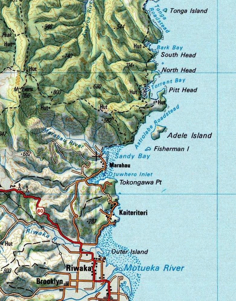
2 A8EL T.4&SMAIV I1IATIO/YAL,44/(K - A Crvis/~ 6u/de Abel Tasman National Park is the smallest of New Zealand's National Parks but unlike other Parks has had a very chequered history with pioneer farming and timber milling severely modifying the landscape. One of the purposes of creating the Park was to allow the native forest to slowly regenerate. The Park is now a very popular recreational area catering for tramping, camping and boating. With its quiet coastline protected from the open sea by Farewell Spit to the west and D'Urville Island to the east the Park has much to offer cruising yachts. The areas near Tasman Bay are sheltered by mountain ranges from ( southerly and easterly winds, and also from the predominating westerlies of the New Zealand area. Thus the region in general has a sunny, mild climate, less windy than most other areas in New Zealand. THE COASTLINE The following notes have been collated from a number of sources for the guidance of members who might be planning a cruise around the Park. While they are believed to be accurate neither the editor nor the Otago Trailer Yacht Squadron can accept responsibility for any errors or omissions. Warning It is vitally important that extreme care is taken when leaving sheltered bays, as the conditions in the bay often give no indication of strong winds and choppy seas prevailing outside. Sudden squalls and williwaws are not uncommon on the coast and care must be taken to watch the weather. The chart covering Tasman Bay is Chart No NZ Other publications which will prove useful to yachties planning to cruise the Park include "A Criusing Guide -Cape Palliser to Marlborough Sounds and Tasman Bay", "Abel Tasman National Park" and particularly "Coastal Photomaps - Tasman and Golden Bay". There are a few pitfalls for trailer yachties that should be remembered when planning a trip to the Park. The price of fresh fruit, vegetables and meat in the Kaiteriteri, Motueka area can be quite horrific and the quality not so good. Visitors not familiar with this coast are warned that the tidal range in Tasman Bay is considerable, being up to 4 meters on spring tides. This contrasts with 2 meters in the Otago Harbour. The inlets that dry out have a sandfly problem which may be troublesome to some people.
3 KAITERITERI ANCHORAGE Kaiteriteri is a very popular holiday resort with a motor camp, store, petrol station, telephone, fresh water and a concrete launching ramp. A trailer park is available near the ramp but sleeping on trailer yachts is prohibited on land except in the Motor Camp. If intending to stay at the Motor Camp during the holiday period a booking would be essential. Because of the 4m tidal range launching and retrieving can be accomplished only at close to high tide. The more adventuresome may Brefer to sail from Nelson. The course from Nelson Entrance is 302 M and the distance is 17 miles. Outlying rocks at the southern end of the bay are marked by unlit beacons. Care should be also be taken in the northern corner of the bay near the launching ramp where there is an unmarked rock awash at low water off the beach. Good anchorage is available south from the low gap inside the northern point in northerly winds. In south-easterly winds the anchorage is untenable and uncomfortable in south-westerly winds. Much of this sheltered area is taken up by permanent moorings. SANDY BAY - MARARAU Keep 1/3 of Honeymoon Bay open until Split Apple Rock is' clear outside of Ngaio Island to clear Ngaio Reef. Sandy Bay is shallow, drying out about half a mile at low water, with no anchorages except off the small beach under Guilbert Point. The anchorage should only be used as a refuge from gale force north westerly wi~ds when the Astrolabe anchorage becomes untenable. Marahau is the start of the walking track through the Abel Tasman National Park and has a camping ground, camp shop and a concrete launching ramp. The ramp can only be used one hour each side of high tide. Fresh water is available. ASTROLABE ROADSTEAD Care should be taken in entering the Roadstead to avoid the sandspit which extends almost halfway across the Roadstead from the southwest point of Adele Island. Adele Island provides a safe sheltered anchorage on the western shore of the Island from all winds except the southwest. Some shelter from the southwesterly may be gained under the sandspit on the southwest end of the anchorage. Very rarely, in extreme northwest gale force winds this anchorage becomes untenable with squalls and williwaws. Fresh water may be found on Adele Island from a small fall or stream on the northern beach of the Island anchorage.
4 From Guilbert Point, the coast on the mainland offers a series of small bays with golden sand and bush almost to the water's edge. give good anchorage in fine northerly sea breeze weather. Fresh water is available from creeks in these bays. All Adolphe Point marks the northern end of the Roadstead and should be given a clearance of at least 50 meters to avoid the sunk reef off the Point. About 500 meters southeast of Adolphe Point is Hapuka Reef. This extensive reef breaks awash at low water with a pinnacle rock which dries 1 meter in fine weather. It is marked by a black conical bouy..! It is safe to pass between Adolphe Point and Hapuka Reef but the coast between Apolphe Point and Pitt Head, known locally as the "Mad Mile", should be given a wide berth because of the short sharp sea which can develop here. Te Puketea Bay can be entered by trailer yachts but care must be taken to avoid the rocks on each side of the entrance. The bay is calm in southwest to westerly weather. Pitt Head is marked by a white and red flashing light. TORRENT BAY Torrent Bay is the most popular anchorage in the Park with its safe all weather anchorage, sandy beaches and better than average weather. As a consequence it can become rather crowded over the summer holidays. :! The Bay provides a variety of anchorages, the best of which is in 4-5 meters sand in the southeast corner opposite the Anchorage Hut. On entering this corner steer for the eastern end of the large sandy beach and look out to port for two sunk rocks almost awash at low water. Holding is excellent allover the Bay, but with the day breeze coming from the north and the night breeze from the southeast, an anchor (Danforth or CQR) which can capsize and relay itself is advisable. A water hose is located on the eastern side of Torrent Bay and a hose and shower rose is piped tb the main beach near the Park Board huts. The Torrent Bay Inlet largely dries out at low water but is navigable at high water with about 2.5 meters over the bar. The current through the entrance may be up to 3 knots. The Inlet is very popular with trailer yachts but legs are required to keep the boat on an even keel when the Inlet dies out. There are many walking tracks around the perimeter of the Inlet. North West Bay provides good anchorage except from easterly weather but dries out between Balloon Rock and the shore.
 i f,,")
5 ABEL TASMAN NATIONAL PARK... il.herln({..., _. 'nca.. "--'''an "'004.., n.._.... -;1 'I :1 K"t"'U _ SCALE HoO.oOO Kllomurh 2 1 I I! t ~ Mil.., I... ) i f,,
6 Boundary Bay has Result Rocks and Totara Rocks on each side of the entrance which are covered at high water but once in the Bay there is shelter from from sea and wind from west to north and from the sea breezes. SANDFLY BAY - FALLS RIVER Sandfly Bay is I mile north of Torrent Bay and may be approached by keeping inshore at low water when the rocks will be exposed. Trailer yachts can enter the Falls Rlver Lagoon but the water in the entrance can be fast flowing. BARK BAY Between Torrent Bay and Bark Bay there is a large number of reefs and rocks that are covered at high water. The entrance to Bark Bay is partly blocked by the Bark Bay Reef which is extensive and dries about I meter at low water springs. Bark Bay may be approached by an inshore course close to the mainland where the dangers are visible at low water. Pass inside the Pinnacle Rocks watching to the east for two isolated rocks between the Pinnacle Rocks and the Bark Bay Reef. A reef extends 50 meters northwards from the South Point which dries 0.6 meter at low water spring. Clear this reef with the west end of the Bark Bay Reef to starboard stand in for the middle of the beach at the head of the Bay. Anchor well out in the center of the Bay. ~e Bay gives shelter from the sea breezes and all winds from southwest to north but is completely exposed to all other wipds and the sea. The Bay shallows gently toward thesandspit separating the Bay from the lagoon. The entrance to the lagoon is on the northern side and is navigable only by small craft or those which can safely dry out. The current in the entrance is fast flowing. A waterhose is provided on the northern shore. A large number of very large boulders are in the watering cove but there is ample depth at high water. TONGA ROADSTEAD Proceeding northwards from Bark Bay, there is a narrow channel between the north head of Bark Bay and the Bark Bay Reef, obstucted by a sunk rock (Whale Rock) which is usually visible in clear weather and a water. Stand north. (mag) until Foul Point is abeam then alter to 308 M towards the western Point of Tonga Island and enter Tonga Roadstead. Onetahuti Beach at the north end of the roadstead provides good anchorage in west to north west weather, but is exposed to weather between the east and southeast and should not be used under these conditions. The Beach shoals in the northern corner at low water.
7 The track to Bark and Awaroa Bays passes behind the Beach. To the east of Onetahuti Beach lies Reef Point with foul ground extending offshore, but just east of the Point is a tiny beach which is well protected from the sea breezes. It is a popular spot for barbeques with deep water and a sandy bottom. Tonga Island lies between the northern and southern extremities of the Roadstead and provides satisfactory shelter from northeast. winds on the southwestern coast. Just to the north of the Island there is a rock which is only meters under at low water spring. From Tonga Roadstead to Abel Head there are several open bays, but with little real shelter for peaceful overnight anchorage. Brereton Cove gives good shelter and anchorage in weather from the ) south and northwest, but otherwise is open to all weather and swells. AWAROA BAY AwaroaBay provides good shelter in the eastern corner in southerly and easterly weather. There are offlying rocks and care must be taken to stay well clear before entering the anchorage. The Bay has a smooth sandy bottom, but dries well out at spring tides. TOTARANUI Totaranui is the Headquarters of the Abel Tasman National Park and is the starting point for the coastal track. It can be reached by road from Takaka and Tarakohe and has a camping 'ground and concrete launching ramp. It can be very crowded during the summer holidays..~~ and Totaranui is very exposed to' weather from the northeast to southeast only affords shelter from winds from the north under the head close to the northwest shore. This anchorage was used by early sailing coasters to await moderate weather to round Separation Point into Golden Bay. From Totaranui to Separation Point only Mutton Cove provides a good anchorage. There is fair protection from northwest weather but it is not a good overnight anchorage because the night breeze usually comes from the southeast. SEPARATION POINT Separation Point is the northern extremity of Tasman Bay and is guarded by a flashing light. The water goes down 9 fathoms all round the Point and a dangerous sea can build up here.
8
West Coast Anchorages
 West Coast Anchorages This document aims to catalogue a number of anchorages along the West Coast of Tasmania where shelter may be sought. In addition the degree of protection from the wind, and holding
Visiting Lake Macquarie
 Visiting Lake Macquarie Lake Macquarie is the largest coastal salt water lake in Australia and is a prime boating destination for both small and large vessels. Many sailing regattas and fishing activities
Dodger Channel. Chart 3671 Map 92C/ N W The southern section is the favoured anchoring area. Good holding. Settled weather only.
 Vancouver Island. West Coast. South to North Burlo Island Cove. Chart 3646. Map 92C/14 48 49N 125 08W At the head of Bamfield Inlet. Anchor on the west or east of Burlo Island. Drying flats. Good holding
Saturday, 8 April Mana and Kapiti or Cook Strait Crossing
 Saturday, 8 April 2017 Mana and Kapiti or Cook Strait Crossing What is this race about? There are plenty of races in New Zealand that take place on inlets, harbours and sheltered waters. The Mana Super
Nautical Maps 1 About New Zealand 2 Nelson Services 3 Sailing Around Nelson 4
 Nautical Maps 1 About New Zealand 2 Nelson Services 3 Sailing Around Nelson 4 Sailing and Marina Information 7 Local Marine Radio 8 Fire Response Plan 9 Marina Rules 11 1 On leisure and recreation visit
Required knowledge for Cook Strait endorsement
 Required knowledge for Cook Strait endorsement Last updated: March 2018 This document is uncontrolled if printed, please refer to the Maritime New Zealand website for the latest version. Cook Strait is
U. S. Coast Guard Sector Boston Merrimack River Approach and Entrance, MA. Waterways Management Survey
 U. S. Coast Guard Sector Boston Merrimack River Approach and Entrance, MA. Waterways Management Survey The Waterways Analysis and Management Survey (WAMS) process is an essential component of both the
SECTION II NM 11/13 NAVIGATION PUBLICATIONS COAST PILOT CORRECTIONS. Chapter 4 Paragraphs 85 to 86; read: (85)
") NAVIGATION PUBLICATIONS COAST PILOT CORRECTIONS COAST PILOT 1 42 Ed 2012 Change No. 13 LAST NM 9/13 Chapter 4 Paragraph 9; read: (9) Round Rock, which uncovers, and The Boring Stone, 3 feet high and bare,
NAVIGATION PUBLICATIONS COAST PILOT CORRECTIONS COAST PILOT 1 42 Ed 2012 Change No. 13 LAST NM 9/13 Chapter 4 Paragraph 9; read: (9) Round Rock, which uncovers, and The Boring Stone, 3 feet high and bare,
Anchoring Is Important
 BCC Sailing Classes - Third Theory Anchoring Anchoring Is Important 1 The Anchor is your last resort. Anchoring Keep off a lee shore. Needs to be shaped (type of anchor) to bury in the type of bottom for
Orkney and Shetland Islands (2016)
") Clyde Cruising Club Amendments to Sailing Directions Clyde Cruising Club Publications Ltd. Orkney and Shetland Islands (2016) This PDF file contains all the amendments for the above volume of the CCC Sailing
Clyde Cruising Club Amendments to Sailing Directions Clyde Cruising Club Publications Ltd. Orkney and Shetland Islands (2016) This PDF file contains all the amendments for the above volume of the CCC Sailing
Only launch your boat once you have a clear understanding of the most up-to-date weather forecast.
 Weather and Tides Observing the Weather Only launch your boat once you have a clear understanding of the most up-to-date weather forecast. Start with television and newspaper weather map reports; they
NORTH HAVEN NORTH HAVEN SLSC
 NORTH HAVEN NORTH HAVEN SLSC Patrols: November to March, weekends and public holidays North Haven beach is the product of a major redevelopment of the northern part of the Adelaide coast. In the 1980s,
Stars and Compass Trophy and Novice Paper 2014!
 Stars and Compass Trophy and Novice Paper 2014 The Stars and Compass Trophy was established to promote the use and development of traditional navigation skills. This year, in a bid to encourage novice
Figure 1, Chart showing the location of the Breach at Old Inlet and sensors deployed in Great South Bay.
 The Impact on Great South Bay of the Breach at Old Inlet Charles N. Flagg and Roger Flood School of Marine and Atmospheric Sciences, Stony Brook University The Great South Bay project (http://po.msrc.sunysb.edu/gsb/)
How To Enter Kushiro Port and Things To Be Aware of When Entering
 How To Enter Kushiro Port and Things To Be Aware of When Entering 1.How to enter Kushiro Port (1)How to enter the East Area When entering the port from Nemuro, navigate while maintaining a safe distance
BookletChart. Intracoastal Waterway Matecumbe to Grassy Key NOAA Chart A reduced-scale NOAA nautical chart for small boaters
 BookletChart Intracoastal Waterway Matecumbe to Grassy Key NOAA Chart 11449 A reduced-scale NOAA nautical chart for small boaters When possible, use the full-size NOAA chart for navigation. Published by
SAILING INSTRUCTIONS MORETON BAY BOAT CLUB PEARL CHALLENGE 2017
 SAILING INSTRUCTIONS MORETON BAY BOAT CLUB PEARL CHALLENGE 2017 Saturday 17 th June and Sunday 18 th June 2017 Organising Authority Moreton Bay Boat Club Inc. at the Redcliffe Peninsula 1. RULES The event
COXSWAIN NAVIGATION EXERCISES AUS197 NAME:
 COXSWAIN NAVIGATION EXERCISES AUS197 NAME: A deviation card is supplied at the end of this file. Check the answers Question 1 Using any chart (or use the AUS 197 extract) to: 1. Identify a distance of
Gordon and Alison s summer cruise in 2016
 Gordon and Alison s summer cruise in 2016 The plan this year was to sail to Oslo and on the way back to visit Limfjord - the waterway which cuts across the north part of the Danish mainland. I had to give
Accident Report. Grounding Sanga Na Langa. 30 March 2006 Class C
 Accident Report Grounding Sanga Na Langa 30 March 2006 Class C REPORT NO.: 06 4041 VESSEL NAME: SANGA NA LANGA Ship Type: Certified Operating Limit: Flag: Commercial Passenger Enclosed & Inshore Limits
WELCOME TO SANDOWN BEACH
 WELCOME TO SANDOWN BEACH Sandown is a recognized award winning beach, very popular for its long sandy beach with safe bathing and a wealth of activities. The local amenities and nearby town makes it a
HARBOR INFRASTRUCTURE INVENTORIES Caseville Harbor, Michigan
 HARBOR INFRASTRUCTURE INVENTORIES Caseville Harbor, Michigan Harbor Location: Caseville Harbor is located at the mouth of the Pigeon River on the east shore of Saginaw Bay, about 17 miles southwest of
ELAN YACHTS COMMODORES CUP SERIES
 ELAN YACHTS COMMODORES CUP SERIES 11 th November 2017 7 th April 2018 The Organising Authority is the Royal New Zealand Yacht Squadron 181 Westhaven Drive, Westhaven, Auckland 1011 PO Box 46182 Herne Bay,
Yaraandoo II Naut 40 Cutter 6 6 draft October 2004 Subject/Area Swains Reefs, Southern End of Great Barrier Reef, Australia
 Yaraandoo II Naut 40 Cutter 6 6 draft October 2004 Subject/Area Swains Reefs, Southern End of Great Barrier Reef, Australia Dear SSCA We thought members might like some information on an infrequently visited
SECTION II NM 26/10 NAVIGATION PUBLICATIONS ALMANACS CORRECTIONS
 NAVIGATION PUBLICATIONS ALMANACS CORRECTIONS NAUTICAL ALMANAC Ed 2011 NEW EDITION (NGA) 26/10 SAILING DIRECTIONS CORRECTIONS PUB 140 8 Ed 2010 NEW EDITION (NGA) 26/10 COAST PILOT CORRECTIONS COAST PILOT
Wexford Harbour. Yachting Guide. Navigation
 Wexford Harbour Yachting Guide Navigation This document supersedes all previous editions. Approvals: Yacht Club Committee April, 2015 Wexford Board of Directors April, 2015 # Date Section Revision 1 6.5.2015
Balmoral Beach to The Spit
 Balmoral Beach to The Spit 2 hrs 30 mins.3 km One way Hard track 85m This walks follows the coast from Balmoral to the Spit and across Spit Bridge. There are some alternate tracks to consider at high-tides,
Extract from Cruising Guide to the Saint Lawrence, Editor Jim Evans, Puffin Press
 Visiting Murray Harbour by Boat Extract from Cruising Guide to the Saint Lawrence, Editor Jim Evans, Puffin Press Murray Harbour 46º 02.1N, 62º 27.1W Canadian Chart 4420 Jim Evans 2016 The photo above
Kayak Trip Yeppoon to Stanage Bay (Central Qld coast)
") Kayak Trip Yeppoon to Stanage Bay (Central Qld coast) August 2018. Robin Aurisch. This trip was inspired by a report on the Upstream Paddle site where 5 paddlers did a similar trip back in 2009. To make
Kayak Trip Yeppoon to Stanage Bay (Central Qld coast) August 2018. Robin Aurisch. This trip was inspired by a report on the Upstream Paddle site where 5 paddlers did a similar trip back in 2009. To make
Essential Safety. in Chichester Harbour. An essential guide for the new or less experienced mariner
 Essential Safety in Chichester Harbour An essential guide for the new or less experienced mariner 01243 512301 www.conservancy.co.uk 1 Enjoying Chichester Harbour in safety Chichester Harbour is renowned
SOUTH GEORGIA Pete and Annie Hill 1995
 RCC PILOTAGE FOUNDATION www.rccpf.org.uk Home>Publications>South Georgia PAH>high res SOUTH GEORGIA Pete and Annie Hill 1995 PETE and ANNIE HILL The RCC Pilotage Foundation is grateful to Pete and Annie
Pointe-des-Monts Cap Whittle
 This is the gateway to that veritable inland sea known as the Gulf of St Lawrence. It is also the door through which the Easterly wind surges into the estuary, forced into the funnel formed by the orth
Accident Report. Unnamed Yacht Beaching - 10 Miles north of Napier on 18 January Class B
 Accident Report Unnamed Yacht Beaching - 10 Miles north of Napier on 18 January 2005 Class B REPORT NO.: 05 1162 UN-NAMED YACHT BEACHING A 6.4 metre trailer sailer with five persons on board was deliberately
LIST OF NOTICES TO MARINERS 2017 PAC 201 JUAN DE FUCA STRAIT AND STRAIT OF GEORGIA, FIRST EDITION, 2012
 1 Chapter 1 After paragraph 154 Insert: 154.1 Pacific Gateway Marina (250-412-5509) is located west of the community wharf. Moorage, gas, diesel, a launching ramp and deep water berths for sailboats are
Fishnish Commercial Pier & Terminal Information Booklet
 Fishnish Commercial Pier & Terminal Information Booklet Welcome to Fishnish Pier. The following information is intended to help ensure that all activities carried out here are done safely, and with a regard
Assessors Name: East Coast OGA Sub Committee Date: 28 April 2015 Persons Affected: Skipper & Crew. Quantifying Risks
 Risk Assessment: EAST COAST RACE EVENT 2015 Risk Assessments of: East Coast Race Event 17 th 19 th July 2015. Man Overboard, Physical Injury or Illness, Sea Sickness, Fire, Gear Failure, Grounding or Shipwreck,
National Maritime Center
 National Maritime Center Providing Credentials to Mariners (Sample Examination) Page 1 of 16 Choose the best answer to the following Multiple Choice Questions. 1. On U.S. charts, you can tell if a named
The Case of the Disappearing Shoreline
 Name The Case of the Disappearing Shoreline Humans change the earth's climate in many ways. One change is the increase of carbon dioxide in the atmosphere. As we burn more fossil fuels, we release more
St. Martin, Antigua & Guadeloupe
 St. Martin, Antigua & Guadeloupe Yacht Charter in St. Martin and Antigua A sailboat holiday in the Leeward Islands - and especially by the many famous islands in the area such as St. Martin and Antigua,
HARBOUR SEDIMENTATION - COMPARISON WITH MODEL
 HARBOUR SEDIMENTATION - COMPARISON WITH MODEL ABSTRACT A mobile-bed model study of Pointe Sapin Harbour, in the Gulf of St. Lawrence, resulted in construction of a detached breakwater and sand trap to
Chart Features Maritime maps and Admiralty charts have these features:
 Introduction to Charts A chart or map of the area is an important safety item to carry on board. It allows the Master to obtain knowledge of the area to be travelled, and indicates the navigable channels
Terrestrial Observations Chart Plot - Chesapeake Bay Entrance - Operational Level
 USCG 00326-NP-5 The following questions are based on chart 12221TR, Chesapeake Bay Entrance, and the supporting publications. The draft of your tow is 27 feet (8.2 meters). Use 10 W variation where required.
A Taste of what others only dream
 A Taste of what others only dream Its been four years since we launched and we have just experienced our first big trip away. Having had to juggle extended family-sailing-trips with fulltime work, high
2018 First National Nelson Regatta
 2018 First National Nelson Regatta Keelboat Rally & Regatta Sunday 21 st Wednesday 24 th January 2018 Sailing Instructions The Organising Authority is the Tasman Bay Cruising Club Inc. (TBCC) PO Box 5062,
APPENDIX 11 WIND EFFECTS ASSESSMENT
 APPENDIX 11 WIND EFFECTS ASSESSMENT Summerset Villages (Lower Hutt) Ltd District Plan Change Request Prepared by Urban Perspectives Ltd 17 September 2014 341 49 342 Opus Research Report 14-529D84.00 Wind
REGION B ONLY. Figure Figure Figure Figure Figure Figure Figure Figure 10.60
 221 REGION B ONLY 10.5 LATERAL MARKS 10.5.1 Description of Lateral marks Port hand marks Shape: pillar buoy (Figures 10.53 and 10.54), can lighted buoy (Figures 10.55 and 10.56) or not lighted (Figures
Shoreline Response to an Offshore Wave Screen, Blairgowrie Safe Boat Harbour, Victoria, Australia
 Shoreline Response to an Offshore Wave Screen, Blairgowrie Safe Boat Harbour, Victoria, Australia T.R. Atkins and R. Mocke Maritime Group, Sinclair Knight Merz, P.O. Box H615, Perth 6001, Australia ABSTRACT
15A NCAC 03J.0103 is amended with changes as published in 30:03 NCR as follows:
 1 1 1 1 1 1 1 1 0 1 0 1 1A NCAC 0J.0 is amended with changes as published in 0:0 NCR 1- as follows: 1A NCAC 0J.0 GILL NETS, SEINES, IDENTIFICATION, RESTRICTIONS (a) It is unlawful to use gill nets: (1)
2018 First National Nelson Regatta
 2018 First National Nelson Regatta for Keelboats, Trailer Yachts & Sport Boats Friday 19 th to Wednesday 24 th January 2018 Notice of Race The Organising Authority is the Tasman Bay Cruising Club (TBCC)
Aids to navigation can include buoys, day beacons, range markers, and lighthouses.
 This boating safety course manual has been approved by Transport Canada strictly on the basis that it meets the minimum requirements of basic boating safety knowledge set out in Transport Canada s Boating
Port of Port Elizabeth Information
 LOCATION Latitude 34º 01 S Longitude 25º 42 E PILOTAGE Pilotage is compulsory. Rendezvous point is 2.2 nautical miles NE of the port entrance on the leading lights. Pilot transfer is by pilot boat, unless
The event or activity may only occur if it is carried out in accordance with: 1. information in the application provided; and
 File: H271 Writer s Direct Dial No. (03) 543 8433 E-mail: harbourmaster@tasman.govt.nz Dave Craig 48 Oak Crescent Ashurst 4810 Dear Dave NAVIGATION SAFETY BYLAW 1 : TEMPORARY RESERVATION AT TORRENT BAY
SECTION 11 ADVENTUROUS ACTIVITIES BOATING: SAILING
 SECTION 11 ADVENTUROUS ACTIVITIES 11.11 BOATING: SAILING 11.11.1. ACTIVITY SCOPE This section relates to the use of small off-the-beach sailing dinghies to conduct sailing activities for members. An off-the-beach
Formation and characteristics of different types of beaches
 Activity Title: Formation and characteristics of different types of beaches Focusing questions What different types of beaches are there in New Zealand? How are estuaries different to open coastal sandy
Abel Tasman HOW TO GET THERE. Themes that are developed at this site: Visitor impact. Tides and life in the estuary. Weed watch
 Abel Tasman Themes that are developed at this site: Visitor impact Tides and life in the estuary Weed watch The Abel Tasman National Park has good quality facilities for schools, on-site accommodation,
ROYAL VANCOUVER YACHT CLUB
 ROYAL VANCOUVER YACHT CLUB PROPOSED EXPANSION PROJECT NAVIGATION CHANNEL DESIGN COAL HARBOUR Prepared for: Royal Vancouver Yacht Club Prepared by: Typlan Consulting Ltd. March 2016 Page 1 of 17 March 23,
National Maritime Center
 National Maritime Center Providing Credentials to Mariners (Sample Examination) Page 1 of 8 Choose the best answer to the following Multiple Choice Questions. 1. Assume that your vessel has just entered
Visiting Lord Howe Island
 Visiting Lord Howe Island Tuesday, October 06, 2015 http://currents.bluewatercruising.org/articles/visiting-lord-howe-island/ Lord Howe is one of several Australian islands scattered around the Mainland.
For more information: Photography: Rijkswaterstaat (Leo Linnartz, Carrie de Wilde, Jurriaan Brobbel, Joop van Houdt), Deltares
, Deltares") Investing in your future. This project was made possible with support from the European Regional Development Fund. Photography: Rijkswaterstaat (Leo Linnartz, Carrie de Wilde, Jurriaan Brobbel, Joop van
Investing in your future. This project was made possible with support from the European Regional Development Fund. Photography: Rijkswaterstaat (Leo Linnartz, Carrie de Wilde, Jurriaan Brobbel, Joop van
HARBOR INFRASTRUCTURE INVENTORIES Port Sanilac Harbor, Michigan
 HARBOR INFRASTRUCTURE INVENTORIES Port Sanilac Harbor, Michigan Harbor Location: Port Sanilac Harbor is located on the west shore of Lake Huron, about 30 miles north of Port Huron, MI. Authority: Rivers
LAB: WHERE S THE BEACH
 Name: LAB: WHERE S THE BEACH Introduction When you build a sandcastle on the beach, you don't expect it to last forever. You spread out your towel to sunbathe, but you know you can't stay in the same spot
SAILING INSTRUCTIONS
 The Formation Marine Gull Rock Manacles Race COGS 3 Sponsored by Formation Marine & South West Play Organising Authority Flushing Sailing Club Sunday 29th May 2016 SAILING INSTRUCTIONS www.cogsracing.org.uk
Regatta Venue Information
 Regatta Venue Information For PORT DALRYMPLE YACHT CLUB At Beauty Point, Tasmania www.pdyc.yachting.org.au Contents Introduction Background Championship Headquarters Location of Host Club Race Area Maps
WHITSUNDAY MULTIHULL RENDEZVOUS Itinerary. 27 August to 2 September Whitsunday Multihull Rendezvous - 27 August to 2 September
 WHITSUNDAY MULTIHULL RENDEZVOUS 2012 27 August to 2 September 2012 Itinerary PLEASE NOTE: This itinerary is subject to change due to unforeseen circumstances and prevailing weather conditions. 1 WELCOME
*Sandy Point State Park Paddling Routes
 *Sandy Point State Park Paddling Routes *Paddleboards are crazy popular in Anne Arundel County creeks and rivers. The life guards on this park s beaches have paddleboards to use in recusing swimmers. Not
The Formation Marine GRP Gull Rock Manacles race
 The Formation Marine GRP Gull Rock Manacles race Sponsored by Formation Marine & South West Play Organising Authority Flushing Sailing Club Sunday 25th May 2014 SAILING INSTRUCTIONS www.cogsracing.org.uk
Harbourmaster s Office Tamaki River. Navigation Safety Operating Requirements 2014
 Harbourmaster s Office Tamaki River Navigation Safety Operating Requirements 2014 Auckland Council Harbourmaster s Office TAMAKI RIVER Navigation Safety Operating Requirements FOREWARD The purpose of these
JUNE 2018 RECREATIONAL SHRIMPING REGULATIONS
 K STATE OF ALABAMA DEPARTMENT OF CONSERVATION AND NATURAL RESOURCES MARINE RESOURCES DIVISION POST OFFICE BOX 189 DAUPHIN ISLAND, AL 36528 TEL (251) 861-2882 FAX (251) 861-8741 JUNE 2018 RECREATIONAL SHRIMPING
JUNE 2018 RECREATIONAL SHRIMPING REGULATIONS
 K STATE OF ALABAMA DEPARTMENT OF CONSERVATION AND NATURAL RESOURCES MARINE RESOURCES DIVISION POST OFFICE BOX 189 DAUPHIN ISLAND, AL 36528 TEL (251) 861-2882 FAX (251) 861-8741 JUNE 2018 RECREATIONAL SHRIMPING
Croatia Flotilla, September 2014
 Croatia Flotilla, September 2014 Once again, we have another wonderful and adventure-filled flotilla planned. This two week cruise along the Croatian coastline will cover approximately 300nm as we take
ASSESSMENT. Heavy Weather Passage Challenger (Kaitaki) 24 October 2006
 24 October 2006") ASSESSMENT Heavy Weather Passage Challenger (Kaitaki) 24 October 2006 1 INTRODUCTION On 24 October 2006, the Cook Strait ferry Challenger sailed from Picton to Wellington encountering storm force conditions.
ASSESSMENT Heavy Weather Passage Challenger (Kaitaki) 24 October 2006 1 INTRODUCTION On 24 October 2006, the Cook Strait ferry Challenger sailed from Picton to Wellington encountering storm force conditions.
Provisions for Moorings
 Provisions for Moorings Tasman Resource Management Plan Summary Guide No. 11 Current: July 2013 1. Introduction Structures and occupation of the coastal marine area (CMA) are managed to control the location
National Maritime Center
 National Maritime Center Providing Credentials to Mariners (Sample Examination) Page 1 of 5 Choose the best answer to the following Multiple Choice Questions. 1. The following questions are based on Chart
Marionette - 55 Years Young, Still Winning, Still Pretty
 Marionette - 55 Years Young, Still Winning, Still Pretty Marionette is a Dolphin 24, hull #12, S&S design #1497, LOA 24', disp. 4500lbs, built in 1960 by Marscot Plastics/O'Day Corporation in Fall River,
Compilation of Anchorages in SW Florida. Document is a compilation of information found from cruisers net and Florida Sea grant publications.
 Compilation of s in SW Florida Document is a compilation of information found from cruisers net and Florida Sea grant publications. Revised 1-2015 CAPE SABLE TO OTTER LIDO KEY ANCHORAGES (Armands circle)
SAILING INSTRUCTIONS BILLY RUN. Saturday 28 April The organising authority (OA) is the South of Perth Yacht Club
 is the South of Perth Yacht Club") SAILING INSTRUCTIONS BILLY RUN Saturday 28 April 2018 The organising authority (OA) is the South of Perth Yacht Club 1. RULES 1.1. The regatta will be governed by the rules as defined in The Racing Rules
SAILING INSTRUCTIONS BILLY RUN Saturday 28 April 2018 The organising authority (OA) is the South of Perth Yacht Club 1. RULES 1.1. The regatta will be governed by the rules as defined in The Racing Rules
Demonstrate basic knowledge of the operation of pleasure/small craft by day
 Page 1 of 7 Title Demonstrate basic knowledge of the operation of pleasure/small craft by day Level 2 Credits 6 Purpose This unit standard is for pleasure craft operators and covers knowledge required
A buoy, for example is an aid to navigation. Aids to navigation include many types of buoys as well as day beacons, range markers, and lighthouses.
 This online study guide has been approved by Transport Canada strictly on the basis that it meets the requirements of the Standard for Pleasure Craft Operator Testing over the Internet (TP 15080E) and
HARBOR INFRASTRUCTURE INVENTORIES Lexington Harbor, Michigan
 HARBOR INFRASTRUCTURE INVENTORIES Lexington Harbor, Michigan Harbor Location: Lexington Harbor is located on the west shore of Lake Huron about 20 miles north of Port Huron, MI. Authority: Rivers & Harbors
Canoe Trip # Maps: 63L Amisk Lake 63M Pelican Narrows
 Canoe Trip #51 49 Southeast Arem Deschambault Lake - Pelican Narrows - Wunehikun Bay - Attitti Lake - Belcher Lake - Mukoman Lake - Ohoo Lake - Mukoman River - Sokatisewin Lake - Sandy Bay 170 Kilometers
Belize. New Castle Sailing Club November 3 10, 2018
 Belize New Castle Sailing Club November 3 10, 2018 Belize Facts at a Glance Total area: 22,960 sq km - Land area: 22,800 sq km - Comparative area: slightly larger than Massachusetts - Land boundaries:
The Marking of Offshore Wind Farms. Provide guidance for a response to IALA. M-4 B445.8 &.9 (& B for on-shore wind farms).
.") CSPCWG2-INF 2 The Marking of Offshore Wind Farms Submitted by: Executive Summary: Chairman (from IALA via IHB) Provide guidance for a response to IALA. Does the Related Project reference have any impact
CSPCWG2-INF 2 The Marking of Offshore Wind Farms Submitted by: Executive Summary: Chairman (from IALA via IHB) Provide guidance for a response to IALA. Does the Related Project reference have any impact
Montessori for Everyone 2013 Types of Coastlines
 Coast The coast is the part of the land that borders the sea. It is subject to constant change, as the result of the waves and deposits carried by water onto the land. Coastline The coastline is where
Appendix 7. Wind and Comfort Impact Analysis
 Appendix 7 Wind and Comfort Impact Analysis Donald Ballanti Consulting Meteorologist 1424 Scott Street El Cerrito, CA 94530 (510) 234-6087 Abe Leider Rincon Consultants 449 15th Street, Suite 303 Oakland,
Great Lakes Fleet CanDependence Cruise June 28 July 6, 2003
 Great Lakes Fleet CanDependence Cruise June 28 July 6, 2003 The images below are of various magnification and characteristics and should not be used in navigation. They are solely to be used in finding
2019 Evolution Sails Nelson Regatta
 2019 Evolution Sails Nelson Regatta for Keelboats, Trailer Yachts & Sport Boats Friday 18 th to Tuesday 22 nd January 2019 Notice of Race The Organising Authority is the Tasman Bay Cruising Club (TBCC)
Nautical Chart Challenge
 Discover Your World With NOAA Nautical Chart Challenge For as long as anyone in his family could remember, Francis Beaufort wanted to make scientific observations from the deck of a ship. In 1789 at the
SOUTH GEORGIA Pete and Annie Hill 1995
 RCC PILOTAGE FOUNDATION www.rccpf.org.uk Home>Publications>South Georgia PAH>high res SOUTH GEORGIA Pete and Annie Hill 1995 PETE and ANNIE HILL The RCC Pilotage Foundation is grateful to Pete and Annie
DESTINATIONS BRISTOL, RI. Wickford, RI
 Bluenose Yacht Charter suggested destinations and itineraries Welcome to some of the most beautiful cruising grounds in the world. Historic, picturesque, easy sailing, reliable winds, excellent weather.
QCYC Bass Strait Cruise March 2018
 QCYC Bass Strait Cruise March 2018 At 122:00pm on Friday 23rd February the three crew of Brigand, my 1976 Spencer 30, departed Westernport Marina at Hastings on an adventure. The plan being to sail in
National Maritime Center
 National Maritime Center Providing Credentials to Mariners (Sample Examination) Page 1 of 19 Choose the best answer to the following multiple choice questions. NO reference materials are authorized for
APRIL 2017 COMMERCIAL SHRIMPING REGULATIONS
 K STATE OF ALABAMA DEPARTMENT OF CONSERVATION AND NATURAL RESOURCES MARINE RESOURCES DIVISION POST OFFICE BOX 189 DAUPHIN ISLAND, AL 36528 TEL (251) 861-2882 FAX (251) 861-8741 APRIL 2017 COMMERCIAL SHRIMPING
WESTHAVEN TRIPLE SERIES SAILING INSTRUCTIONS
 WESTHAVEN TRIPLE SERIES 12 th November 2016 22 nd April 2017 The Organising Authorities are the Royal New Zealand Yacht Squadron (RNZYS) Ponsonby Cruising Club (PCC) & Richmond Yacht Club (RYC) SAILING
Chittagong, Bangladesh (Asia Region)
") General Information: Port Information (Asia Region) Extract of port information from Chittagong Port Authority: The Port of Chittagong is the principal Port of the People's Republic of Bangladesh. It is
General Information: Port Information (Asia Region) Extract of port information from Chittagong Port Authority: The Port of Chittagong is the principal Port of the People's Republic of Bangladesh. It is
Brooklin, Maine, Event Announcement. A rendezvous sponsored by. Traditional Small Craft Association Downeast Chapter
 !1 Small Reach Regatta Brooklin, Maine, 2018 Event Announcement A rendezvous sponsored by Traditional Small Craft Association Downeast Chapter Atlantic Boat, Herrick Bay, Maine July 25 29, 2018 !2 Thanks
NOTICE TO MARINERS. No 03 of Port of Southampton Precautionary Area (Thorn Channel)
") NOTICE TO MARINERS No 03 of 2016 (Update and Re-Issue of Notice to Mariners No 03 of 2014) Port of Southampton Precautionary Area (Thorn Channel) 1 NOTICE IS HEREBY GIVEN that all vessels navigating within
NOTICE TO MARINERS No 03 of 2016 (Update and Re-Issue of Notice to Mariners No 03 of 2014) Port of Southampton Precautionary Area (Thorn Channel) 1 NOTICE IS HEREBY GIVEN that all vessels navigating within
Frequently Asked Questions
 Frequently Asked Questions For marine users of the Olympic sailing waters during the London 2012 Games 1st June 2012 1 Contents Page 2 Journey Planning 4 Berthing, Mooring and Anchorage 5 Restrictions
MAHURANGI CRUISING CLUB
 MAHURANGI CRUISING CLUB ENCOURAGING CRUISING AND THE OWNERSHIP, USE AND RESTORATION OF WOODEN BOATS Mahurangi Regatta - SAILING INSTRUCTIONS Saturday 26 th January 2019Saturday 26 th January 2019 The Mahurangi
Upstreampaddle 25.South arm of the Brunswick River, Simpson s Creek drains the freshwater swamp lands of Tyagarah Nature Reserve, 750 hectares. Furthe
 Upstreampaddle 24 The Brunswick River is a shorter length river on the coastal plain of Northern New South Wales. The areas of interest to canoeists are: the reach from the town of Mullumbimby down to
Impacts of breakwaters and training walls
 Across the eastern seaboard of Australia, breakwaters and training walls have instigated fundamental perturbations to coastal and estuary processes. This has induced long-term changes to foreshore alignments,