Balmoral Beach to The Spit
|
|
|
- Leslie Carter
- 6 years ago
- Views:
Transcription


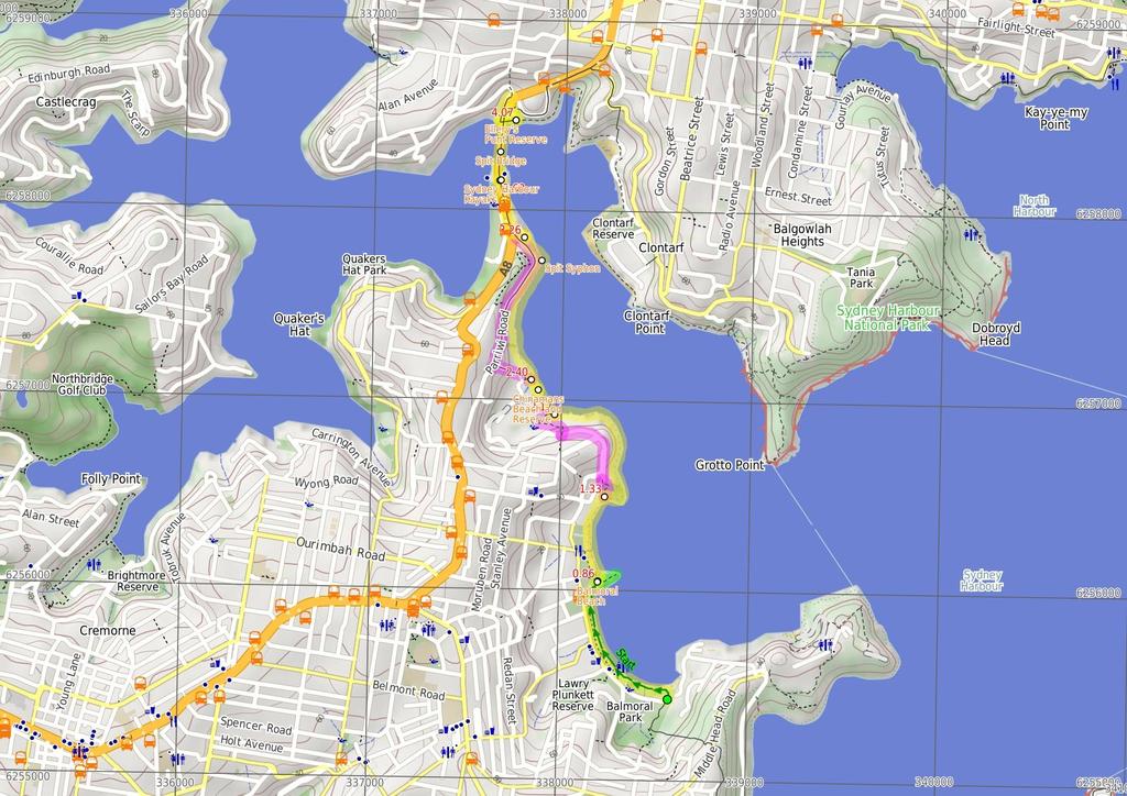
1 Balmoral Beach to The Spit 2 hrs 30 mins.3 km One way Hard track 85m This walks follows the coast from Balmoral to the Spit and across Spit Bridge. There are some alternate tracks to consider at high-tides, which take the streets over the headlands. Balmoral and Chinamans Beaches are very nice places for lunch and a swim. Allows time to wander and explore. There are plenty of options for swimming. Maps, text & images are copyright wildwalks.com Thanks to OSM, NASA and others for data used to generate some map layers. 0m Mosman LGA 17m
2 Balmoral Beach Balmoral Beach takes its name from the royal castle at Braemar in Scotland. This is a beautiful beach, with a great foreshore walk overlooking the sandy beach. The beach is a popular spot with locals and visitors, for sun baking, swimming and having a picnic. Balmoral Beach has very little surf, with a sheltered, easterly aspect. There is also a shark-net swimming area, toilets, shops, cafes and plenty of beach to share on a sunny day. Chinamans Beach and Reserve Chinamans Beach and Reserve are wonderful places to have a picnic or a swim, with lots of areas to sit in the sun or shade beside the clear water. The beach does not provide any surf with its northeasterly aspect, but is perfect for launching your kayak or boat into the harbour. Chinamans Reserve has some parking, play equipment, toilets and road access by McLean Cres. Spit Syphon The Spit Syphon was built between 1922 and 1925 by the Public Works Department. It was necessary in order to pump sewage from the north without interfering with water transport. The building is styled with Egyptian influences as displayed by its tall, square concrete walls. More info. Sydney Harbour Kayaks Sydney Harbour Kayaks, at the southern end of the Spit Bridge, provide sales and rentals of kayaks. One hour in a single plastic kayak costs $20, and a double $0. The enterprise also provides tours of the harbour, catering for individuals through to large groups. For further information and bookings, contact: info@sydneyharbourkayaks.com.au or (02) More info. Spit Bridge The Spit Bridge was originally built in 192 to replace the punt service. The current Spit Bridge was built during the 1950's. The bridge is a bascule bridge, as it's middle section can be raised to allow tall ships through. This ability of the bridge does, however, stop traffic on a major arterial road, which has caused the bridge to be the centre of some controversy. The Spit Bridge carries the Spit Rd and the Manly Scenic Walkway. Before You walk Bushwalking is fun and a wonderful way to enjoy our natural places. Sometimes things go bad, with a bit of planning you can increase your chance of having an ejoyable and safer walk. Before setting off on your walk check 1) Weather Forecast (BOM Metropolitan District) 2) Fire Dangers (Greater Sydney Region, unknown) 3) Park Alerts () ) Research the walk to check your party has the skills, fitness and equipment required 5) Agree to stay as a group and not leave anyone to walk solo Think before you TREK The 'Think before you TREK' program developed by NSW Police & NPWS promotes the benefits of planning ahead for your bushwalking trip by using an easy to remember acronym: T R E K Take adequate supplies of food, water, navigation and first aid equipment. Register your planned route and tell friends and family when you expect to return. Emergency beacon (PLB's) should be carried on walks with significant gaps in mobile coverage (check terrain profile). Keep to your planned route and follow the map and walking trails. Topo Maps The maps provided on wildwalks are helpful, but there are times where you may need maps covering a broader area. Maps that cover this walk include; 1: Map Series:91303N PARRAMATTA RIVER, 91302N SYDNEY HEADS 1: Map Series:9130 SYDNEY Grade This walk has been graded using the AS The overall grade of the walk is dertermined by the highest classification along the whole track. Length Time Quality of track Grade /6 Hard track.3 km One way 2 hrs 30 mins Rough track, where fallen trees and other obstacles are likely (/6) Signs Minimal directional signs (/6) Experience Required Weather Infrastructure Moderate level of bushwalking experience recommended (/6) Storms may impact on navigation and safety (3/6) Limited facilities, not all cliffs are fenced (3/6)
3 Are you ready to have fun? Please ensure you and your group are well prepared and equipped for all possible hazards and delays. Check park closures, weather information and Fire Danger Rating before setting out. Optional side trips and alternate routes noted are not included in this walks overall grade, length or time estimate. Please allow extra time for resting and exploring areas of interest. The authors, staff and owners of wildwalks take care in preparing this information but will not accept responsibility for any inconvenience, loss or injury you may experience. Please take care, have fun - Happy Walking. Getting there You can get to Balmoral Park car park (gps: , ) by car or bus. Car: There is free parking available. You can get back from Int. Battle Boulevard and Manly Rd (gps: , ) by car or bus. Car: There is free parking available. Find up to date and more information inlcuding; travel directions, weather, park closures and walker feedback at 0 Balmoral Park car park (860 m 1 mins) From Balmoral Park car park, this walk heads onto the beach and follows along it, past the pipe and wharf, then continues up the beach to then head up the stairs onto the bridge, connecting the small rocky island to the promenade above the beach Balmoral Beach Balmoral Beach takes its name from the royal castle at Braemar in Scotland. This is a beautiful beach, with a great foreshore walk overlooking the sandy beach. The beach is a popular spot with locals and visitors, for sun baking, swimming and having a picnic. Balmoral Beach has very little surf, with a sheltered, easterly aspect. There is also a shark-net swimming area, toilets, shops, cafes and plenty of beach to share on a sunny day Optional sidetrip to Rocky Point (110 m 2 mins) Turn right: From the intersection, this walk heads up the hill towards the sea. The walk passes a few bench seats and bins on the way out to the edge of the point. At the end of this side trip, retrace your steps back to the main walk then Turn right Rocky Point Bridge (80 m 8 mins) Continue straight: From the bridge, this walk heads along the beach to the north, keeping the sea to the right, towards the headland. The walk heads along the beach for approximately 200m, to the intersection just off the beach, past the last beachfront house Alternate Route Int. Wyargine Reserve Trk and Balm (850 m 18 mins) Veer left: From the intersection just behind the beach, this walk winds up stairs away from the beach, to a rocky outcrop where the track turns. The walk then continues up the hill to meet the signposted intersection at the end of Stanton Rd. Continue straight: From the intersection, this walk heads up the road following 'Stanton Rd' then 'Burran Ave' signs, to veer left onto Hopetoun Ave. The walk soon passes Kirk Oswald Ave (off to the left). After a while the road again splits into two levels, opposite the intersection of Armitage Rd. Turn right: From the intersection, this walk heads down the hill, following the sign 'Armitage Lane' along the road, and around to the left into Rosherville Rd. The walk continues along the footpath, passing a large boulder and a bench on the right before winding down behind the playground in Rosherville Reserve. The track passes the playground, taking the closest access track to the southern end of Chinamans Beach. Now Turn sharp left to rejoin the main walk Int. Wyargine Reserve Trk and Balmoral Beach (80 m 16 mins) Turn right: (This section is only possible at low tide and with calm seas.) From the intersection, this walk heads away from the houses and towards the rockshelf, keeping the bush on the left. The walk keeps the water to the right as it weaves around the rockshelf for approximately 500m, to some boat sheds with rail tracks into the water. From these boat sheds, the walk continues to follow the rocky headland to the beach Chinamans Beach and Reserve Chinamans Beach and Reserve are wonderful places to have a picnic or a swim, with lots of areas to sit in the sun or shade beside the clear water. The beach does not provide any surf with its north-easterly aspect, but is perfect for launching your kayak or boat into the harbour. Chinamans Reserve has some parking, play equipment, toilets and road access by McLean Cres Chinamans Beach Reserve South (230 m mins) Turn right: From the end of the beach, this walk heads along the sand, keeping the water to the right, until near the middle of Chinamans Beach. A wood-railed track heads off to the toilet block on the left, marking the intersection. Continue straight: From the intersection, this walk heads along the beach with the water to the right. The walk leads to the stairs at the end of the beach. 2. Alternate Route Int. Grecia Lane Trk and Chinamans (1.1 km 25 mins) Turn left: From the base of the stairs (at the northern end of Chinamans Beach), this walk heads up the stairs away from the beach, to the intersection with Cyprian St. The track heads to the right, up Cyprian St, to the intersection with Parriwi Rd. At Parriwi Rd, the walk turns right, around the railing and up the hill. The walk continues along Parriwi Rd for some time, down to the intersection with Spit Rd. The walk continues along Spit Rd, to the driveway entry to Middle Harbour Yacht Club car park. Now Veer right to rejoin the main walk. 2. Int. Grecia Lane Trk and Chinamans Beach Reserve N (860 m 16 mins) Veer right: From the intersection, this walk heads along the rocky shoreline with the water to the right, as it weaves around the houses to a small beach. The walk continues over some sandy sections between the rocks for approximately 700m, to come to a large Sydney Water building, the Spit Syphon. The walk climbs onto the concrete platform of the Spit Syphon to continue along the road, passing 'The Shores' restaurant and a boat ramp. The walk continues past the Middle Harbour Yacht Club building to the main entrance facing the car park Spit Syphon The Spit Syphon was built between 1922 and 1925 by the Public Works Department. It was necessary in order to pump sewage from the north without interfering with water transport. The building is styled with Egyptian influences as displayed by its tall, square concrete walls. More info Middle Harbour Yacht Club entrance (360 m 6 mins) Veer left: From the entrance of Middle Harbour Yacht Club, this walk heads away from the buildings to the road. Turn right: From the intersection, this walk heads along Spit Rd towards the bridge, keeping the shops on your right. The walk heads along the road to where it splits, to go over the bridge, opposite 'Sydney Harbour Kayaks' Sydney Harbour Kayaks Sydney Harbour Kayaks, at the southern end of the Spit Bridge, provide sales and rentals of kayaks. One hour in a single plastic kayak costs $20, and a double $0. The enterprise also provides tours of the harbour, catering for individuals through to large groups. For further information and bookings, contact: info@sydneyharbourkayaks.com.au or (02) More info Spit Bridge South (350 m 6 mins) Continue straight: From the intersection, this walk heads over the Spit Bridge, with the road to the left of the footpath. The walk crosses the bridge to where it meets the road down to Ellery's Punt Reserve, first on the right Spit Bridge The Spit Bridge was originally built in 192 to replace the punt service. The current Spit Bridge was built during the 1950's. The bridge is a bascule bridge, as it's middle section can be raised to allow tall ships through. This ability of the bridge does, however, stop traffic on a major arterial road, which has caused the bridge to be the centre of some controversy. The Spit Bridge carries the Spit Rd and the Manly Scenic Walkway Int. Spit Rd and Ellery's Punt Reserve Road (100 m 2 mins) Veer right: From the intersection, this walk heads downhill away from the main road for approximately 20m to the intersection below the bridge, on the left. Veer right: From the intersection, this walk heads down the hill towards the water. The walk soon comes to Ellery's Punt Reserve car park on the right. This walk continues past this, down the footpath to the signposted intersection..07 Ellery's Punt Reserve Ellery's Punt Reserve is a very nice grassed area on the north eastern side of the Spit Bridge. The reserve has road access and parking, and seems to be a popular spot for fishing from the bank. There is also seating and shaded areas..07 Int. Ellery's Punt Reserve Rd and Manly Scenic Wal (230 m 5 mins) Turn right: From the 'Manly Scenic Walkway' map and info sign, this walk heads across the grass following the coast line, keeping the water to the left and heading towards the "Ellery's Punt Reserve" sign. From the sign, the walk passes under the Spit Bridge and then up the flight of stairs that come to the end of Battle Boulevard. Continue straight: From the end of the cul-de-sac, this walk follows Battle Bvd up the road to the car park just near the intersection with Manly Road.
4
5 Powered by TCPDF ( Summary navigation sheet for the Balmoral Beach to The Spit km From Up/Dwn Length Initial directions (Use full tracknotes and maps for more detail) Start Balmoral Park car park , (GR Sydney Heads, 38655) m 1 mins From Balmoral Park car park, this walk heads onto the beach and follows along it, past the pipe and wharf, then continues up the beach to then head up the stairs onto the bridge, connecting the small rocky island to Rocky Point Bridge , (GR Sydney Heads, ) m 2 mins Optional sidetrip to Rocky Point. Turn right: From the intersection, this walk heads up the hill towards the sea Rocky Point Bridge , (GR Sydney Heads, ) m 8 mins Continue straight: From the bridge, this walk heads along the beach to the north, keeping the sea to the right, towards the headland Int. Wyargine Reserve Trk and Balmoral Beach , (GR Sydney Heads, ) m 18 mins Alternate Route Int. Wyargine Reserve Trk and Balmoral Beach. Veer left: From the intersection just behind the beach, this walk winds up stairs away from the beach, to a rocky outcrop where the track turns Int. Wyargine Reserve Trk and Balmoral Beach , (GR Sydney Heads, ) m 16 mins Turn right: (This section is only possible at low tide and with calm seas.) From the intersection, this walk heads away from the houses and towards the rockshelf, keeping the bush on the left Chinamans Beach Reserve South , (GR Parramatta River, ) m mins Turn right: From the end of the beach, this walk heads along the sand, keeping the water to the right, until near the middle of Chinamans Beach. 2.0 Int. Grecia Lane Trk and Chinamans Beach Reserve North , (GR Parramatta River, ) km 25 mins Alternate Route Int. Grecia Lane Trk and Chinamans Beach Reserve North. Turn left: From the base of the stairs (at the northern end of Chinamans Beach), this walk heads up the stairs away from the beach, to the intersection with Cyprian St. 2.0 Int. Grecia Lane Trk and Chinamans Beach Reserve North , (GR Parramatta River, ) m 16 mins Veer right: From the intersection, this walk heads along the rocky shoreline with the water to the right, as it weaves around the houses to a small beach Middle Harbour Yacht Club entrance , (GR Parramatta River, ) m 6 mins Veer left: From the entrance of Middle Harbour Yacht Club, this walk heads away from the buildings to the road Spit Bridge South , (GR Parramatta River, ) m 6 mins Continue straight: From the intersection, this walk heads over the Spit Bridge, with the road to the left of the footpath Int. Spit Rd and Ellery's Punt Reserve Road , (GR Parramatta River, ) m 2 mins Veer right: From the intersection, this walk heads downhill away from the main road for approximately 20m to the intersection below the bridge, on the left..07 Int. Ellery's Punt Reserve Rd and Manly Scenic Walkway , (GR Parramatta River, ) m 5 mins Turn right: From the 'Manly Scenic Walkway' map and info sign, this walk heads across the grass following the coast line, keeping the water to the left and heading towards the "Ellery's Punt Reserve" sign.
Spit Bridge to Middle Head Forts
 Spit Bridge to Middle Head Forts 2 hrs 30 mins 6.3 km One way Hard track 4 181m This scenic walk takes you from the Spit Bridge, along the coast to explore the Middle Head Forts. There are a few alternate
Currie Rd to Davidson Park
 Currie Rd to Davidson Park 3 hrs 7.2 km One way Moderate track 28m Starting at Currie Rd in Forestville, this walk follows Middle Harbour to Davidson Park, under Roseville Bridge. There are two optional
Govetts Leap Loop. 1065m. 909m Blue Mountains National Park. 4 hrs 30 mins 8.7 km Circuit. Hard track 380m
 Govetts Leap Loop 4 hrs 30 mins 8.7 km Circuit Hard track 380m This walk, from Blackheath Train Station, is a fantastic way to see some of the iconic areas of the Blue Mountains in the Blackheath area.
Rail to River Walk. 3 hrs. Hard track 7.5 km Circuit. 222m
 Rail to River Walk 3 hrs Hard track 7.5 km Circuit 4 222m This walk is a great one from Chatswood Station to the Lane Cove River National Park. The walk descends through the vegetated bushland which fills
Hunters Hill to Epping Road
 Hunters Hill to Epping Road 2 hrs 30 mins 5.5 km One way Moderate track 154m An enjoyable walk through lower sections of the Lane Cove National Park, this walk features plenty of mangroves next to the
The Foreshore Walk. 24m. 1m Lake Macquarie LGA. 1 hr 15 mins 2.9 km One way. Hard track 81m
 The Foreshore Walk 1 hr 15 mins 2.9 km One way Hard track 81m This walk traverses the coastline of the Green Point reserve. By following a variety of tracks and occasionally traveling inland through eucalyptus
Morgans Creek to Padstow
 Morgans Creek to Padstow 2 hrs 45 mins 8 km One way Moderate track 3 144m This pleasant walk starts from the Morgans Creek park, at Henry Lawsons Drive, and follows the Georges River past the Boomerang
Taronga Zoo to Spit Bridge
 Taronga Zoo to Spit Bridge 5 hrs Hard track 1.4 km One way 4 41m This is a scenic and culturally rich walk with views over Sydney Harbour and many interesting heritage buildings along the way. The start
Popes Glen, Pulpit Rock, Govetts Leap and Braeside Walk
 Popes Glen, Pulpit Rock, Govetts Leap and Braeside Walk 8 hrs Hard track 13.6 km Circuit 4 1068m This large circuit walk, from Popes Glen to Pulpit Rock, Govetts leap and along the Braeside Track, passes
Wattamolla to Big Marley Beach
 Wattamolla to Big Marley Beach 4 hrs 10.4 km Circuit Moderate track 4m This walk is an excellent loop which takes in both the coast and the heathy inland of Royal National Park. Nearly the whole walk has
Wallarah Coastal Walk
 Wallarah Coastal Walk 3 hrs 8.3 km Return Hard track 247m This walk starts at Caves Beach and travels south along the coastline, until reaching the Pinney s Headland Lookout. There are many opportunities
Little Digger Track. 68m. 1 Hr 2.2 km One way. Moderate track 93m. Moores Creek Reserve
 Little Digger Track Hr 2.2 km One way Moderate track 93m This walk follows Moores Creek through several reserves in east Roseville and East Lindfield. The track is named after Australia's 7th Prime Minster,
Echo Point to Leura Forest via Three Sisters and Giant Stairs loop
 Echo Point to Leura Forest via Three Sisters and Giant Stairs loop 3 hrs 3.8 km Circuit Hard track 512m This walk starts from the popular Echo Point, in Katoomba, and winds down to the base of the Three
Sid Pulsford Walk. 175m. 33m. 1 hr 45 mins 4.1 km One way. Hard track 118m. Gosford LGA
 Sid Pulsford Walk 1 hr 5 mins.1 km One way Hard track 118m Sid Pulsford Walk explores the ridge top of Kincumber Mountain, from Honeman's Rock to Green Point. The walk mostly follows wide management trails.
The Basin Track and Mackerel Track
 The Basin Track and Mackerel Track 3 hrs 5.9 km Circuit Hard track 226m This walk is a great way to see some popular areas in Ku-ring-gai Chase National Park. The walk from West Head Rd travels to The
Waterfall to Heathcote
 Waterfall to Heathcote 5 hrs Hard track 10.8 km One way 4 467m This walk explores the heart of Heathcote National Park, and is easily accessed with a train station at either end. Although relatively close
Carrington Park to Leura Forest and pass loop
 Carrington Park to Leura Forest and pass loop 3 hrs Hard track 4.8 km Circuit 4 674m This walk is a fantastic way to see Leura Forest. The walk descends from Carrington Park, visiting Leura Forest and
Little Digger Track to Davidson Reserve and Lyrebird Circuit
 Little Digger Track to Davidson Reserve and Lyrebird Circuit 4 hrs 3 mins 11.5 km One way Hard track 4 47m Exploring both the eastern and western sides of Middle Harbour Creek, this walk follows the Little
Mackerel Beach and Resolute Loop
 Mackerel Beach and Resolute Loop 3 hrs 5.4 km Circuit Hard track 384m This walk is another great walk in Ku-ring-gai Chase National Park, accessed by ferry. From the Mackerel Beach wharf, this walk uses
Epping to Pennant Hills Station (via Lane Cove River)
") Epping to Pennant Hills Station (via Lane Cove River) 3 hrs 5 mins 8.4 km One way Hard track 249m This walk, from Epping to Pennant Hills Station, is a great way to see the upper Lane Cove River Valley.
Epping to Pennant Hills Station (via Lane Cove River) 3 hrs 5 mins 8.4 km One way Hard track 249m This walk, from Epping to Pennant Hills Station, is a great way to see the upper Lane Cove River Valley.
Katoomba Falls Circuit
 Katoomba Falls Circuit hr 5 mins.5 km Circuit Hard track 59m For those looking for a walk involving more than simple boardwalk, this trail winding through the temperate rain forest could be just the thing.
Wentworth Falls Conservation Hut Loop
 Wentworth Falls Conservation Hut Loop 3 hrs Hard track 6.7 km Circuit 4 341m This scenic walk from Wentworth Falls Station, winds along the Nature Trail to Conservation Hut, then drops into the magnificent
Epping to Eastwood Station (via Lane Cove River)
") Epping to Eastwood Station (via Lane Cove River) hrs 45 mins 10.2 km One way Moderate track 189m Epping to Eastwood, via Lane Cove River, is the longer route through the bush between the stations. This
Epping to Eastwood Station (via Lane Cove River) hrs 45 mins 10.2 km One way Moderate track 189m Epping to Eastwood, via Lane Cove River, is the longer route through the bush between the stations. This
Heathcote to Engadine via Audley
 Heathcote to Engadine via Audley 6 hrs 3 mins 5 km One way Hard track 4 635m Covering a large section of central Royal National Park, this walk goes through the heath and scrub along a well managed and
Rail to River and Stringybark Creek Reserve Walk
 Rail to River and Stringybark Creek Reserve Walk 4 hrs Hard track 11.2 km Circuit 4 302m This walk begins in the busy city of Chatswood and soon enters the nearby bushland around the Lane Cove River. The
Bouddi Coastal Walk. 5 hrs. Hard track 8.1 km One way. 364m
 Bouddi Coastal Walk 5 hrs Hard track 8.1 km One way 4 364m This is one of the longer walks in the Bouddi National Park and it is rich in scenery. The walk follows the coastline with many side trips to
Campbell Drive to Snapper Point
 Campbell Drive to Snapper Point 1 hr 45 mins 4.2 km One way Experienced only 135m This walk follows the Coast Track to Frazer Beach, along the Geebung and (overgrown) Grass Tree Tracks. From the northern
Mackerel Beach, West Head Loop
 Mackerel Beach, West Head Loop 5 hrs 8.6 km Circuit Hard track 422m The Mackerel Beach, West Head Loop is a walk which explores a large part of the West Head. The journey starts and finishes with a ferry
Scenic World to Echo Point
 Scenic World to Echo Point 1 hr 15 mins 2.1 km One way Moderate track 192m This is one of the most popular tourist walks in the Katoomba area. The walk follows the cliffs along a well maintained and signposted
Woolwich Wharf to Boronia Park
 Woolwich Wharf to Boronia Park 2 hrs 5.8 km One way Moderate track 175m Going through the streets of Hunters Hill, this walk is on the first segment of the Great North Walk. The majority of the walk is
Callicoma Loop. 174m. 98m. 2 hrs. Hard track 5.1 km Circuit. 153m
 Callicoma Loop 2 hrs Hard track 5.1 km Circuit 153m This great circuit walk passes through some really nice forest around the fringe of Cherrybrook. Highlights of the walk include some beautiful rock overhangs
Teralba to Charlestown Park track head
 Teralba to Charlestown Park track head 4 hrs 30 mins 13.3 km One way Moderate track 3 220m This section of the Great North Walk starts from the Teralba train station and winds down and around the edge
Green Point Circuit Walk
 Green Point Circuit Walk 3 hrs 7.7 km Circuit Hard track 269m This walk visits all of the popular locations in Green Point Reserve, as well as some of the lesser-visited areas inland. Taking in Sea Eagle
Hornsby Blue Gum Walk
 Hornsby Blue Gum Walk 3 hrs Hard track 6.7 km Circuit 4 374m This delightful loop is one of the prettiest and most popular walks in the Hornsby area. Going from an environment of ferns and clear bushland
Spit Bridge to Manly (Manly Scenic Walkway)
") Spit Bridge to Manly (Manly Scenic Walkway) 3 hrs 45 mins 9.1 km One way Moderate track 349m The Spit to Manly walk is a classic bushwalk on Sydney's Northern Beaches. The walk follows a well-maintained
Spit Bridge to Manly (Manly Scenic Walkway) 3 hrs 45 mins 9.1 km One way Moderate track 349m The Spit to Manly walk is a classic bushwalk on Sydney's Northern Beaches. The walk follows a well-maintained
Dead Horse Gap Loop track
 Dead Horse Gap Loop track 4 hrs 30 mins Hard track 9.8 km Circuit 144m 4 This walk starts with a ride up the Kosciuszko Express Chairlift. There is an opportunity to eat at Australia's highest restaurant,
Taronga Wharf to Chowder Bay
 Taronga Wharf to Chowder Bay 2 hrs 4.4 km One way Moderate track 246m Starting at Taronga Wharf, this walk passes many icons of Sydney, including Taronga Zoo, HMAS Sydney Mast, Chowder Bay. The walk also
Middle Harbour Creek Loop
 Middle Harbour Creek Loop 5 hrs 45 mins 15.1 km Circuit Experienced only 5 570m This walk explores the upper reaches of Middle Harbour Creek, starting and ending at the great parklands at Davidson Park,
De Burghs Bridge to Fullers Bridge
 De Burghs Bridge to Fullers Bridge 2 hrs 3 mins Hard track 6 km One way 2m 4 Following the Lane Cove River, this walk mostly follows a section of the Great North Walk and is well maintained and signposted.
Blackheath Station to Junction Rock Loop (via Grand Canyon and Popes
 Blackheath Station to Junction Rock Loop (via Grand Canyon and Popes 8 hrs 30 mins 18.2 km Circuit Hard track 4 1254m This circuit starts in Blackheath and heads down into the Grand Canyon and Rodriguez
Upper Rumbalara circuit
 Upper Rumbalara circuit 1 hr 30 mins 3.3 km Circuit Hard track 176m A great circuit walk, covering most of the walking tracks and sights in the upper section of the Rumbalara Reserve. There is some really
Hermitage Foreshore Track
 Hermitage Foreshore Track 1 Hr 2.2 km One way Moderate track 123m The Hermitage Foreshore Walk is a wonderful way to explore Sydney Harbour from the perspective of South Head. This walk starts from Nielsen
Berowra to Mt Kuring-gai
 Berowra to Mt Kuring-gai 4 hrs 30 mins 9.4 km One way Hard track 4 551m From the ridges above Cowan Creek, this walk takes in some great lookouts (especially around Mt Kuringgai) as well as enjoying an
De Burgs Bridge to Thornleigh station
 De Burgs Bridge to Thornleigh station 3 hrs 45 mins 9.7 km One way Hard track 4 363m This walk follows a section of the Great North Walk, starting from De Burghs bridge. The walk winds north west, through
Sphinx, Warrimoo and Bobbin Head tracks
 Sphinx, Warrimoo and Bobbin Head tracks 4 hrs 9.6 km Circuit Moderate track 499m This great walk starts at the Sphinx Memorial and loops around via Cowan Creek, exploring diverse environments as it changes
Manly to Seaforth Oval
 Manly to Seaforth Oval 5 hrs 45 mins 13.7 km One way Moderate track 3 624m This walk follows the Manly to Spit Scenic Walkway, then continues past The Spit Bridge to Seaforth Oval. The walk provides magnificent
Roseville to Macquarie Park
 Roseville to Macquarie Park 3 hrs 3 mins 8.8 km One way Hard track 4 29m This walk starts at Roseville station and explores the streets and alleyways of Roseville before joining the main spine of the Great
National Pass from Wentworth Falls to Conservation Hut
 National Pass from Wentworth Falls to Conservation Hut 3 hrs Hard track 3.6 km One way 739m Starting at Wentworth Falls picnic area, this scenic and historic walk explores many waterfalls, lookouts and
Epping to Gordon Station
 Epping to Gordon Station 4 hrs 15 mins 11.7 km One way Hard track 4 365m This walk, from Epping Station to Gordon Station, passes below the homes which sit on the hills high above the Lane Cove River.
Patonga to Woy Woy. 5 hrs 45 mins 15.5 km One way. Hard track. 497m
 Patonga to Woy Woy 5 hrs 45 mins 15.5 km One way Hard track 4 497m This walk explores a variety of environments from the shore line and coastal cliffs near Patonga, to the dry, rocky and open ridge line.
Glenbrook and Euroka Circuit
 Glenbrook and Euroka Circuit 2 Days 16.6 km Circuit Experienced only 790m This two day circuit, returning to Glenbrook Station, is a scenic walk which passes many of the tourist attractions within the
Under and Over Cliff Walk
 Under and Over Cliff Walk 4 hrs 9.4 km Circuit Moderate track 576m This walk from Wentworth Falls Station is a fantastic way to see a large majority of the Wentworth Falls cliffline. The track winds under
Gordon to Chatswood Station
 Gordon to Chatswood Station 4 hrs 30 mins 12.2 km One way Hard track 4 381m This walk is a great way to get into the bush without being far from civilisation. The walk wanders through untouched valleys
Federal Pass Walking Track
 Federal Pass Walking Track 5 hrs Hard track 8 km One way 4 989m This classic trail follows along the base of the cliffs from Leura to the Golden Stairs, passing many of the more popular sights of the Katoomba
Echo Point to Leura Forest Circuit
 Echo Point to Leura Forest Circuit 3 hrs 4.8 km Circuit Hard track 588m Forming a circuit around the cliffs and then the valley floor, this is a walk more then capable of convincing a walker of the beauty
Wentworth Falls Station Loop (Undercliff Walk)
") Wentworth Falls Station Loop (Undercliff Walk) 4 hrs 3 mins Hard track 8.9 km Circuit 658m 4 This walk passes some stunning waterfalls and views into the Jamison Valley, following the cliff edges around
Wentworth Falls Station Loop (Undercliff Walk) 4 hrs 3 mins Hard track 8.9 km Circuit 658m 4 This walk passes some stunning waterfalls and views into the Jamison Valley, following the cliff edges around
Dubbo Gully and Ten Mile Hollow Circuit (via Clares Bridge)
") Dubbo Gully and Ten Mile Hollow Circuit (via Clares Bridge) 2 Days Hard track 24.3 km Circuit 4 1117m This two day (or ten hour) walk follows several historic roads, now closed to traffic. Starting with
Dubbo Gully and Ten Mile Hollow Circuit (via Clares Bridge) 2 Days Hard track 24.3 km Circuit 4 1117m This two day (or ten hour) walk follows several historic roads, now closed to traffic. Starting with
North Ryde Fairyland circuit
 North Ryde Fairyland circuit 2 hrs 30 mins Hard track 6.9 km Circuit 193m 4 Starting at North Ryde train station this walk explores a stretch of the Lane Cove River, visiting the historic Fairlylands Pleasure
Lane Cove Tourist Park River Circuit
 Lane Cove Tourist Park River Circuit 5 hrs 12 km Circuit Hard track 383m This walk follows a large section of Lane Cove River. The walk follows the Riverside Walking track up the Lane Cove River to De
Sphinx to Mt Kuring-gai
 Sphinx to Mt Kuring-gai 4 hrs 45 mins 1.7 km One way Hard track 673m This walk starts at the Sphinx War Memorial and follows some well maintained and popular walking tracks down to Cowan Creek. Enjoy the
Bouddi Ridge and Coastal Walk
 Bouddi Ridge and Coastal Walk 2 Days Hard track 27 km Circuit 4 126m This overnight walk takes in the majority of the magnificent Bouddi National Park. The walk starts from the pleasant Putty Beach camping
Wentworth Falls Station Loop
 Wentworth Falls Station Loop 5 hrs 3 mins 9.5 km Circuit Hard track 4 13m The Wentworth Falls Station Loop takes in most of the upper tracks around Wentworth Falls. There are many scenic views near the
Cape Banks Circuit. 50m. 2m Botany Bay National Park. 3 hrs 7.3 km Circuit. Hard track 190m
 Cape Banks Circuit 3 hrs 7.3 km Circuit Hard track 19m This Cape Banks Circuit has a lot to offer and is thoroughly recommended. The walking travels over beaches, through coastal forest and across exposed
Wentworth Falls Loop. 893m. 665m. 6 hrs 10.2 km Circuit. Hard track 1093m. Blue Mountains National Park
 Wentworth Falls Loop 6 hrs 1.2 km Circuit Hard track 193m This is a great walk, both in size and spectacular views. The walk makes its way from Wentworth Falls train station and drops off the plateau,
Charlestown Park trackhead to Newcastle station
 Charlestown Park trackhead to Newcastle station 5 hrs 30 mins 12.1 km One way Hard track 4 287m This section of the Great North Walk starts from the Charleston Park track head and winds through the streets
The Coast Track. 2 Days. Hard track 27.4 km One way. 1351m
 The Coast Track 2 Days Hard track 27.4 km One way 4 1351m Heading south, this walk covers the coastline of the Royal National Park and can truly only be described as amazing. With breathtaking coastal
Gosford to Lisarow. 202m
 Gosford to Lisarow 4 hrs 3 mins Hard track 11.3 km One way 4 479m This walk is a great way to explore the ridge-top bushland between Gosford and Lisarow. Passing through Rumbalara and Katandra Reserves,
Faulconbridge to Blaxland
 Faulconbridge to Blaxland 2 Days Experienced only 15.2 km One way 5 693m This two-day walk, or very solid one-day walk, takes you from station to station, through lush, scenic forest in the lower Blue
Thornleigh to Hornsby
 Thornleigh to Hornsby 4 hrs Hard track 10.2 km One way 4 526m Starting at Thornleigh station you walk through suburban streets for a short while before diving into the bush at the southern end of Berowra
MAP BOOKLET IMPORTANT CONTACTS SUNDAY 24 MARCH In an emergency please call 000 Medics. Event contacts
 SUNDAY 24 MARCH 2019 Help raise funds for the Cancer Centre for Children at The Children s Hospital at Westmead MAP BOOKLET IMPORTANT CONTACTS In an emergency please call 000 Medics (02) 8005 MEDIC or
Chatswood to Epping Station
 Chatswood to Epping Station 6 hrs Hard track 16.3 km One way 4 533m This walk, from Chatswood to Epping, is a long but enjoyable walk along the Lane Cove valley. The walk mostly follows the Lane Cove River
Bobbin Head Loop. 166m. 0m Ku-ring-gai Chase National Park. 5 hrs 12.9 km Circuit. Hard track 619m
 Bobbin Head Loop 5 hrs 12.9 km Circuit Hard track 619m This great circuit walk enjoys a variety of landscapes in Ku-ring-gai Chase National Park. The walk starts at the historic Sphinx war memorial and
Narrabeen Lagoon Trail (from Middle Creek)
") Narrabeen Lagoon Trail (from Middle Creek) 2 hrs 30 mins 8.6 km Circuit Very easy 1 105m The Narrabeen Lagoon Trail is a wonderful and accessible walk on the Northern Beaches of Sydney. The trail is used
Narrabeen Lagoon Trail (from Middle Creek) 2 hrs 30 mins 8.6 km Circuit Very easy 1 105m The Narrabeen Lagoon Trail is a wonderful and accessible walk on the Northern Beaches of Sydney. The trail is used
Scenic world to Three Sisters Loop via Furber Steps
 Scenic world to Three Sisters Loop via Furber Steps 5 hrs 5.8 km Circuit Hard track 722m This walk starts from the popular Scenic World, in Katoomba, and winds down the Furber steps into the Jamison Valley,
Rumbalara Explorer. 158m. 5m Rumbalara Reserve. 2 hrs 45 mins 6.1 km Circuit. Hard track 326m
 Rumbalara Explorer 2 hrs 5 mins 6.1 km Circuit Hard track 326m Pretty well the grand tour of the Rumbalara Reserve, this walk takes in much of the great scenery the reserve has to offer. The walk covers
Light to Light Walk 2 days
 Light to Light Walk 2 days 2 Days Hard track 3.9 km One way 4 794m Over two days, this classic walk explores the coast from Boyd Tower to the Green Cape Lighthouse in the south. Hegartys Bay Camp is over
Harbour Bridge to Taronga Zoo
 Harbour Bridge to Taronga Zoo 4 hrs 9.8 km One way Moderate track 389m On this walk, you will explore much of the foreshore linking Milsons Point Station to Taronga Zoo Ferry wharf. The walk is mostly
Sydney to Thornleigh via Lane Cove Tourist Park
 Sydney to Thornleigh via Lane Cove Tourist Park 2 Days 33 km One way Hard track 4 1114m This overnight walk starts from the Obelisk in Macquarie Park, Sydney, at the official start of the Great North Walk.
Six Foot Track. 1212m
 Six Foot Track 3 Days 44.8 km One way Hard track 4 2066m This classic walk takes you from Katoomba to Jenolan Caves via a historic horse route. The walk travels mainly along well-maintained service tracks
Christchurch to Hengistbury Head
 Last checked 6 June 2018 Document last updated: 13 July 2018 This document and information herein are copyrighted to Saturday Walkers Club. If you are interested in printing or displaying any of this material,
Start / Finish. Version 2
 Start / Finish Version 2 Gosford (Start) to Woy Woy Head South down Etna Street, crossing Henry Parry Drive, then Mann St, Gosford, where Etna St becomes Racecourse Road. Follow this road all the way
Directions for Day 1: Colwood To Metchosin
 Colwood-Metchosin Page 1 of 8 Directions for Day 1: Colwood To Metchosin Start: Royal Roads University, Birds of a Feather B&B, or at Esquimalt Lagoon Finish: Your accommodation in Metchosin Time: 4-5
SELF GUIDED TOURING ROUTE
 SELF GUIDED TOURING ROUTE Things to see and places to go on the loop from Orbost to Marlo, Cape Conran, Cabbage Tree and back to Orbost (or onwards to Cann River) V6 April 2017 This guide should be read
ST. AGNES. you cannot put a time limit on beauty.
 ST. AGNES CIRCULAR WALKS AROUND There are many enjoyable and picturesque walks around St. Agnes most are signposted and are featured on the St. Agnes Mini-guide map. Because most of our footpaths are in
THE FIRST MOUNTAIN BIKE TRAIL CENTRE IN THE GCC & MIDDLE EAST
 THE FIRST MOUNTAIN BIKE TRAIL CENTRE IN THE GCC & MIDDLE EAST INTRODUCTION WELCOME TO HATTA TRAIL CENTRE WEBSITE Hatta Trail Centre is a first MTB Centre in the Middle East, and is a home to multiple cross
EXECUTIVE SUMMARY Callan Park accommodates travel from a wide range of transport modes, including walking, cycling, bus and light rail.
 TRANSPORT AND ACCESS EXECUTIVE SUMMARY Callan Park accommodates travel from a wide range of transport modes, including walking, cycling, bus and light rail. Whilst there are some walking facilities within
COURSE MAP
 CHICAGO 2012 URBANATHLON COURSE MAP 1. Plastic Barricades and Police Barricade Combo 2. Cargo Net and Traffic Cones with Poles Combo 3. Police Barricades and Tire Stutter Step Combo 4. Subaru Crawl, Marine
Chichester Harbour. A Walker s Guide
 A Walker s Guide - Chichester Harbour Chichester Harbour A Walker s Guide Chichester Harbour is an Area of Outstanding Natural Beauty on the south coast of Britain. Virtually flat with far reaching sea
Walk 7: Watchet to washford
 Walk 7: Watchet to washford Length: Moderate - 7.5 miles / 12 km Good For: Theme: History Duration: 2-3 hours depending on speed of walking Notes: This is a moderate to difficult walk in places, with steps,
RILLINGTON TO MALTON by Tania Dickinson
 RILLINGTON TO MALTON by Tania Dickinson This walk takes you from the Vale of Pickering up on to the Wold scarp, before dropping down again through the pretty village of Settrington and joining the Centenary
The Year Of Mercy Pilgrimage Sts Peter and Paul s Church, Bulimba To The Cathedral of St Stephen
 The Year Of Mercy Pilgrimage Sts Peter and Paul s Church, Bulimba To The Cathedral of St Stephen Dist Route Photos Photos 0.0km St Peter and Paul s Church, 235 Riding Rd & Cnr Main Ave, Balmoral. http://www.bulimbacatholic.com/
Masson Hill. Walk. Approximately 4 km. Moderate Walk Begins from Matlock Railway Station
 Masson Hill Walk Approximately 4 km Moderate Walk Begins from Matlock Railway Station TOWN WALKS Masson Hill walk is approx. 4 km. It can be walked in a couple of hours or so. Enjoy your walk and the beautiful
VELINDRE VALLEYS WALK FOR STEFFAN
 VELINDRE VALLEYS WALK FOR STEFFAN IMPORTANT INFORMATION FOR WALKERS AND MARSHALS 1 Table of Contents Key Contact Numbers:... 3 Timetable and locations... 4 T-shirts... 4 Important Advice for Walkers...
Surfers Against Sewage Are Calling For A Review of the UK s Bathing Water Sample Sites.
 Surfers Against Sewage Are Calling For A Review of the UK s Bathing Water Sample Sites. Welsh Report Surfers Against Sewage (SAS) believe the weekly bathing water samples required by the EU Bathing Water
WELCOME TO RYDE. Access Statement for Ryde, Isle of Wight
 WELCOME TO RYDE Ryde Beach is situated to the north of Ryde Town Centre and is accessible either by foot, car or public transport. This is one of the most popular resorts for day trippers, holiday makers
London to Southend-on-Sea Trek map
 FIGHT FOR EVERY HEARTBEAT London to Southend-on-Sea Trek map Route stats: 100 km (62 miles) with metres of climbing Start: Fulham Palace 9:00am Half Way / Start for 50km: CEME Centre 9.00pm Finish: Southend-on-sea
WELCOME TO SANDOWN BEACH
 WELCOME TO SANDOWN BEACH Sandown is a recognized award winning beach, very popular for its long sandy beach with safe bathing and a wealth of activities. The local amenities and nearby town makes it a
Maps The maps provided are a guide and are not to scale. Please use OS Explorer Map 120 (Chichester).
.") A Walker s Guide - Chichester Harbour Useful Information Directions All the walks were tested in 2013. Please note, however, that some footpaths may be diverted and buildings such as pubs may have changed
A Walker s Guide - Chichester Harbour Useful Information Directions All the walks were tested in 2013. Please note, however, that some footpaths may be diverted and buildings such as pubs may have changed
*Sandy Point State Park Paddling Routes
 *Sandy Point State Park Paddling Routes *Paddleboards are crazy popular in Anne Arundel County creeks and rivers. The life guards on this park s beaches have paddleboards to use in recusing swimmers. Not
This will bring you out onto Trafalgar Square. Trafalgar Square is normally buzzing with activity.on your right is the National Gallery, and outside
 A Walk past sites of Central London, starting from Charring Cross and ending at London Bridge Station Take the train from Tonbridge to Charring Cross. This will take about 40 mins. As you exit the station