Spit Bridge to Middle Head Forts
|
|
|
- Gladys McDaniel
- 5 years ago
- Views:
Transcription


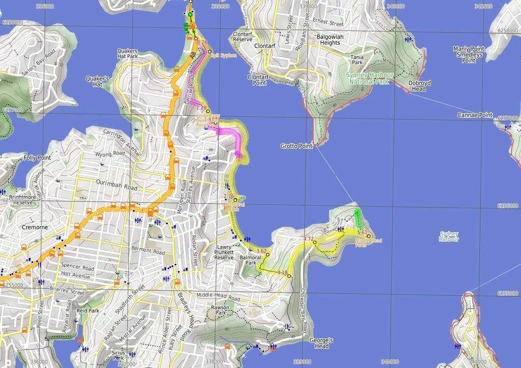
1 Spit Bridge to Middle Head Forts 2 hrs 30 mins 6.3 km One way Hard track 4 181m This scenic walk takes you from the Spit Bridge, along the coast to explore the Middle Head Forts. There are a few alternate routes for use at high tide or high seas. Balmoral Beach offers a few spots for a coffee or fish and chips along the way. Middle Head offers plenty of options for exploring the old forts and enjoying a view out the heads. 68m 1m Sydney Harbour National Park Maps, text & images are copyright wildwalks.com Thanks to OSM, NASA and others for data used to generate some map layers.

2 Spit Bridge Before You walk The Spit Bridge was originally built in 1924 to replace the punt service. The current Spit Bridge was built during the 1950's. The bridge is a bascule bridge, as it's middle section can be raised to allow tall ships through. This ability of the bridge does, however, stop traffic on a major arterial road, which has caused the bridge to be the centre of some controversy. The Spit Bridge carries the Spit Rd and the Manly Scenic Walkway. Bushwalking is fun and a wonderful way to enjoy our natural places. Sometimes things go bad, with a bit of planning you can increase your chance of having an ejoyable and safer walk. Before setting off on your walk check Spit Syphon The Spit Syphon was built between 1922 and 1925 by the Public Works Department. It was necessary in order to pump sewage from the north without interfering with water transport. The building is styled with Egyptian influences as displayed by its tall, square concrete walls. More info. Chinamans Beach and Reserve Chinamans Beach and Reserve are wonderful places to have a picnic or a swim, with lots of areas to sit in the sun or shade beside the clear water. The beach does not provide any surf with its northeasterly aspect, but is perfect for launching your kayak or boat into the harbour. Chinamans Reserve has some parking, play equipment, toilets and road access by McLean Cres. Balmoral Beach Balmoral Beach takes its name from the royal castle at Braemar in Scotland. This is a beautiful beach, with a great foreshore walk overlooking the sandy beach. The beach is a popular spot with locals and visitors, for sun baking, swimming and having a picnic. Balmoral Beach has very little surf, with a sheltered, easterly aspect. There is also a shark-net swimming area, toilets, shops, cafes and plenty of beach to share on a sunny day. Middle Head Forts The forts of Middle Head consist of a rabbit warren of concrete tunnels, winding some 300m around the end of the headland. The fortifications and gun emplacements are varied in size and state, with some closed to protect heritage and the bats. Nearly all the forts overlook the harbour, with views out past the heads and to sea. This is a great area for a little adventure with so many tunnels to explore. For information on tours, click the link. More info. 1) Weather Forecast (BOM Metropolitan District) 2) Fire Dangers (Greater Sydney Region, unknown) 3) Park Alerts (Sydney Harbour National Park) 4) Research the walk to check your party has the skills, fitness and equipment required 5) Agree to stay as a group and not leave anyone to walk solo Think before you TREK The 'Think before you TREK' program developed by NSW Police & NPWS promotes the benefits of planning ahead for your bushwalking trip by using an easy to remember acronym: adequate supplies of food, water, navigation and first T Take aid equipment. your planned route and tell friends and family when R Register you expect to return. beacon (PLB's) should be carried on walks with E Emergency significant gaps in mobile coverage (check terrain profile). to your planned route and follow the map and walking K Keep trails. Topo Maps The maps provided on wildwalks are helpful, but there are times where you may need maps covering a broader area. Maps that cover this walk include; 1: Map Series:91303N PARRAMATTA RIVER, 91302N SYDNEY HEADS 1: Map Series:9130 SYDNEY Grade This walk has been graded using the AS The overall grade of the walk is dertermined by the highest classification along the whole track. 4 Grade 4/6 Hard track Length 6.3 km One way Time 2 hrs 30 mins Quality of track Rough track, where fallen trees and other obstacles are likely (4/6) Signs Minimal directional signs (4/6) Experience Required Moderate level of bushwalking experience recommended (4/6) Weather Storms may impact on navigation and safety (3/6) Infrastructure Limited facilities, not all cliffs are fenced (3/6)
3 Are you ready to have fun? Please ensure you and your group are well prepared and equipped for all possible hazards and delays. Check park closures, weather information and Fire Danger Rating before setting out. Optional side trips and alternate routes noted are not included in this walks overall grade, length or time estimate. Please allow extra time for resting and exploring areas of interest. The authors, staff and owners of wildwalks take care in preparing this information but will not accept responsibility for any inconvenience, loss or injury you may experience. Please take care, have fun - Happy Walking. Getting there You can get to Spit Bridge South (gps: , ) by car or bus. Car: There is free parking available. You can get back from Int. Middle Head Rd and Chowder Bay Rd (gps: , ) by car or bus. Car: There is free parking available. Find up to date and more information inlcuding; travel directions, weather, park closures and walker feedback at 0 Spit Bridge The Spit Bridge was originally built in 1924 to replace the punt service. The current Spit Bridge was built during the 1950's. The bridge is a bascule bridge, as it's middle section can be raised to allow tall ships through. This ability of the bridge does, however, stop traffic on a major arterial road, which has caused the bridge to be the centre of some controversy. The Spit Bridge carries the Spit Rd and the Manly Scenic Walkway. 0 Spit Bridge South (280 m 5 mins) From the intersection opposite 'Sydney Harbour Kayaks', this walk heads down along Spit Rd, on the right, to turn left before the hill into Middle Harbour Yacht Club's car park Alternate Route Int. Middle Harbour Yacht Club car (1.1 km 25 mins) Veer left: From the intersection, this walk heads up Parriwi Rd, along the hill above the yacht club (the club being below on the left). The walk heads up the road for quite some time, then takes the first left, Cyprian St, which it follows down the hill to a signpost for 'Grecia Lane'. From here, the walk leaves Cyprian St to head down the stairs passing a small grassed area with a bench, before heading down more stairs onto Chinamans Beach. Now Turn right to rejoin the main walk Int. Middle Harbour Yacht Club car park and Spit R (930 m 17 mins) Turn left: From the intersection, this walk heads through the car park towards the Middle Harbour Yacht Club buildings entrance. Veer right: From the Middle Harbour Yacht Club entrance, this walk heads along the road which goes behind the club building. The walk passes a boat ramp on the left and 'The Shores' restaurant before turning right, around the front of the Sydney Water 'Spit Syphon' building platform. From the platform, the walk drops down onto the rocky shore and continues to wind around and through the rocks for some time. As the walk meanders along the rocky shore, it passes over some sandy sections to then come out onto Chinamans Beach Reserve, heading to the bottom of the stairs (to the right) Spit Syphon The Spit Syphon was built between 1922 and 1925 by the Public Works Department. It was necessary in order to pump sewage from the north without interfering with water transport. The building is styled with Egyptian influences as displayed by its tall, square concrete walls. More info Int. Grecia Lane Trk and Chinamans Beach Reserve N (70 m 1 mins) Veer left: From the intersection, this walk heads along the beach, keeping the water to the left. The walk leads to a point on the beach where a wood-railed track leads to the toilet block off to the right Chinamans Beach and Reserve Chinamans Beach and Reserve are wonderful places to have a picnic or a swim, with lots of areas to sit in the sun or shade beside the clear water. The beach does not provide any surf with its north-easterly aspect, but is perfect for launching your kayak or boat into the harbour. Chinamans Reserve has some parking, play equipment, toilets and road access by McLean Cres Middle of Chinamans Beach (160 m 3 mins) Continue straight: From the middle of Chinamans Beach, near the wood-railed track, this walk heads down the beach, keeping the water to the left. The walk continues to the end of the beach, where there are numerous boats and surf ski's under the trees Alternate Route Chinamans Beach Reserve South to I (850 m 18 mins) Turn sharp right: From the southern end of Chinamans Beach, this walk heads up the closest track off the beach, keeping the hill to the left of the track. This area is littered with small boats and surf skis. The track comes out near Rosherville Reserve playground, but turns left before reaching the it. The walk heads up the hill behind the houses (on the right) to the signposted intersection of 'Rosherville Rd' and 'Armitage Lane'. The walk then heads up the hill, coming to Hopetoun Ave just across from where the road joins together again. Turn left : From the intersection, this walk heads up Hopetoun Ave, away from the split levels in the road. The walk passes Kirk Oswald Ave (off to the right) and then veers right, where the road changes its name to Burran Ave, and soon splits into two levels again. As the road bends right again, this walk instead continues straight ahead into Stanton Rd. The track heads to the signposted intersection at the end of the road. Continue straight: From the intersection, this walk heads down the steps towards the beach and through a rocky outcrop. The track turns left, winding to the intersection just behind the beach. Now Veer right to rejoin the main walk Chinamans Beach Reserve South (1.3 km 24 mins) Turn left: (This section is only possible at low tide and with calm seas.) From the southern end of the beach, this walk heads along the rockshelf, keeping the sea to the left. The walk leads towards the boat sheds with rails, taking the easiest route across the rockshelf for approximately 500m to come out onto Balmoral Beach. The track then continues up the beach for approximately 50m, coming to an intersection with a small track, just before the houses. Turn left: From the intersection, this walk heads down the beach keeping the water to the left. The walk continues for approximately 200m to the bridge that connects the promenade footpath to the rocky island. The walk climbs the stairs onto the bridge Balmoral Beach Balmoral Beach takes its name from the royal castle at Braemar in Scotland. This is a beautiful beach, with a great foreshore walk overlooking the sandy beach. The beach is a popular spot with locals and visitors, for sun baking, swimming and having a picnic. Balmoral Beach has very little surf, with a sheltered, easterly aspect. There is also a shark-net swimming area, toilets, shops, cafes and plenty of beach to share on a sunny day Rocky Point Bridge (860 m 14 mins) Continue straight: From the bridge, this walk heads down the stairs onto the beach, keeping the water to the left. The walk continues along the beach for approximately 100m to the pipe and wharf, then continues along the sand to turn off the beach at Balmoral Sailing Club on the right into the car park Balmoral Park car park (570 m 15 mins) Continue straight: From the intersection, this walk heads away from the car park and beach to pass '1st Balmoral Sea Scouts' and a childcare centre, on the left. The walk then continues along the footpath outside of the oval to a signposted intersection. Turn left: From the intersection, this walk heads away from the oval, across a bridge. The walk then climbs a few flights of stairs to enter a fenced area with many signs. This walk continues for some time up stairs to turn right, through the fence and continues up stairs to the intersection with Middle Head Rd Int. Middle Head Rd and Chowder Bay Trk (540 m 10 mins) Turn left: From the intersection, this walk heads down the road towards the fence, away from the houses. The road tends right as it comes into HMAS Penguin. The walk continues along Middle Head Rd to the intersection with Chowder Bay Rd, opposite the oval Int. Middle Head Rd and Chowder Bay Rd (600 m 12 mins) Turn right: From the intersection of Chowder Bay and Middle Head Rd, this walk heads down through the car park to the far end, where there are signs. The walk heads along the fenceline passing the Sydney Harbour NP sign. The fencline is followed as it tends right, coming to a gate. Veer left: From the intersection, this walk heads through the gate, keeping the view of the water to the right of the track. Note that if the gate is closed, visitors can walk around the right-hand side of the fence. The walk then follows the fenceline, (on the left of the track), to then continue up a small hill along the fenceline and to a short stone wall. The walk continues over the stone wall to the fork in the road Int. Old Fort and Govenors Rds (190 m 3 mins) Turn right: From the intersection, this walk heads up 'Old Fort Rd', keeping the unfenced cottage on the right of the road. The walk soon passes a radio tower on the right, and continues past a gate to the intersection, opposite a sign in the clearing on the left. 5.5 Optional sidetrip to Disappearing Gun Pit North (270 m 6 mins) Turn left: From the intersection, this walk heads away from the built-up forts and road, to cross the clearing to the signposted 'Inner Middle Head Forts'. The track follows the arrow on this sign for approximately 200m through the bush to a sunken concrete fort on the right. Continue straight: From the southern fort (surrounded by bush), this walk winds right, away from the fort keeping the sea on the right of the track. The track quickly leads to an intersection near the fort at the sea cliff. Veer right: From the intersection, this walk heads towards the concrete gun pit and the sea, approximately 20m away. At the end of this side trip, retrace your steps back to the main walk then Turn left. 5.5 Int. Lower Barracks Trk and Old Fort Rd (110 m 2 mins) Continue straight: From the intersection, this walk heads along the overgrown management trail to the tallest of the forts. From here, walkers can explore the fortifications Middle Head Forts The forts of Middle Head consist of a rabbit warren of concrete tunnels, winding some 300m around the end of the headland. The fortifications and gun emplacements are varied in size and state, with some closed to protect heritage and the bats. Nearly all the forts overlook the harbour, with views out past the heads and to sea. This is a great area for a little adventure with so many tunnels to explore. For information on tours, click the link. More info Tallest Fort (650 m 12 mins) Turn around: From the tallest fort, this walk heads away

4 from the sea and the forts, along an overgrown management trail. The walk comes to an intersection opposite a sign, on the far side of the clearing. Continue straight: From the intersection, this walk heads up the road, away from the forts and into the bush. The walk passes a gate and a radio tower on the left. This walk continues to the fork of Old Fort and Govenors Rds. Continue straight: From the intersection, the walk heads down Middle Head Rd, away from the houses, to an entrance to the NPWS depot (a driveway with a wire fence). Continue straight: From the intersection, the walk heads down Middle Head Road, away from the old cottage-style houses and fork in the road. The walk continues past houses, left and right, and then an oval on the right, after which it comes to an intersection in the roads.
5
6 Summary navigation sheet for the Spit Bridge to Middle Head Forts km Up/Dwn Length Initial directions (Use full tracknotes and maps for more detail) Start Spit Bridge South , (GR Parramatta River, ) 0.28 Int. Middle Harbour Yacht Club car park and Spit Rd , (GR Parramatta River, ) m 5 mins 1.1 km 25 mins From the intersection opposite 'Sydney Harbour Kayaks', this walk heads down along Spit Rd, on the right, to turn left before the hill into Middle Harbour Yacht Club's car park. Alternate Route Int. Middle Harbour Yacht Club car park and Spit Rd. Veer left: From the intersection, this walk heads up Parriwi Rd, along the hill above the yacht club (the club being below on the left) Int. Middle Harbour Yacht Club car park and Spit Rd , (GR Parramatta River, ) m 17 mins Turn left: From the intersection, this walk heads through the car park towards the Middle Harbour Yacht Club buildings entrance Int. Grecia Lane Trk and Chinamans Beach Reserve North , (GR Parramatta River, ) m 1 mins Veer left: From the intersection, this walk heads along the beach, keeping the water to the left Middle of Chinamans Beach , (GR Parramatta River, ) Chinamans Beach Reserve South , (GR Parramatta River, ) Chinamans Beach Reserve South , (GR Parramatta River, ) Rocky Point Bridge , (GR Sydney Heads, ) Balmoral Park car park , (GR Sydney Heads, ) Int. Middle Head Rd and Chowder Bay Trk , (GR Sydney Heads, ) Int. Middle Head Rd and Chowder Bay Rd , (GR Sydney Heads, ) Int. Old Fort and Govenors Rds , (GR Sydney Heads, ) Int. Lower Barracks Trk and Old Fort Rd , (GR Sydney Heads, ) Int. Lower Barracks Trk and Old Fort Rd , (GR Sydney Heads, ) Tallest Fort , (GR Sydney Heads, ) m 3 mins 850 m 18 mins 1.3 km 24 mins 860 m 14 mins 570 m 15 mins 540 m 10 mins 600 m 12 mins 190 m 3 mins 270 m 6 mins 110 m 2 mins 650 m 12 mins Continue straight: From the middle of Chinamans Beach, near the wood-railed track, this walk heads down the beach, keeping the water to the left. Alternate Route Chinamans Beach Reserve South. Turn sharp right: From the southern end of Chinamans Beach, this walk heads up the closest track off the beach, keeping the hill to the left of the track. Turn left: (This section is only possible at low tide and with calm seas.) From the southern end of the beach, this walk heads along the rockshelf, keeping the sea to the left. Continue straight: From the bridge, this walk heads down the stairs onto the beach, keeping the water to the left. Continue straight: From the intersection, this walk heads away from the car park and beach to pass '1st Balmoral Sea Scouts' and a childcare centre, on the left. Turn left: From the intersection, this walk heads down the road towards the fence, away from the houses Powered by TCPDF ( From Turn right: From the intersection of Chowder Bay and Middle Head Rd, this walk heads down through the car park to the far end, where there are signs. Turn right: From the intersection, this walk heads up 'Old Fort Rd', keeping the unfenced cottage on the right of the road. Optional sidetrip to Disappearing Gun Pit North. Turn left: From the intersection, this walk heads away from the built-up forts and road, to cross the clearing to the signposted 'Inner Middle Head Forts'. Continue straight: From the intersection, this walk heads along the overgrown management trail to the tallest of the forts. Turn around: From the tallest fort, this walk heads away from the sea and the forts, along an overgrown management trail.
Balmoral Beach to The Spit
 Balmoral Beach to The Spit 2 hrs 30 mins.3 km One way Hard track 85m This walks follows the coast from Balmoral to the Spit and across Spit Bridge. There are some alternate tracks to consider at high-tides,
Currie Rd to Davidson Park
 Currie Rd to Davidson Park 3 hrs 7.2 km One way Moderate track 28m Starting at Currie Rd in Forestville, this walk follows Middle Harbour to Davidson Park, under Roseville Bridge. There are two optional
Hunters Hill to Epping Road
 Hunters Hill to Epping Road 2 hrs 30 mins 5.5 km One way Moderate track 154m An enjoyable walk through lower sections of the Lane Cove National Park, this walk features plenty of mangroves next to the
Rail to River Walk. 3 hrs. Hard track 7.5 km Circuit. 222m
 Rail to River Walk 3 hrs Hard track 7.5 km Circuit 4 222m This walk is a great one from Chatswood Station to the Lane Cove River National Park. The walk descends through the vegetated bushland which fills
Morgans Creek to Padstow
 Morgans Creek to Padstow 2 hrs 45 mins 8 km One way Moderate track 3 144m This pleasant walk starts from the Morgans Creek park, at Henry Lawsons Drive, and follows the Georges River past the Boomerang
Govetts Leap Loop. 1065m. 909m Blue Mountains National Park. 4 hrs 30 mins 8.7 km Circuit. Hard track 380m
 Govetts Leap Loop 4 hrs 30 mins 8.7 km Circuit Hard track 380m This walk, from Blackheath Train Station, is a fantastic way to see some of the iconic areas of the Blue Mountains in the Blackheath area.
Popes Glen, Pulpit Rock, Govetts Leap and Braeside Walk
 Popes Glen, Pulpit Rock, Govetts Leap and Braeside Walk 8 hrs Hard track 13.6 km Circuit 4 1068m This large circuit walk, from Popes Glen to Pulpit Rock, Govetts leap and along the Braeside Track, passes
Wallarah Coastal Walk
 Wallarah Coastal Walk 3 hrs 8.3 km Return Hard track 247m This walk starts at Caves Beach and travels south along the coastline, until reaching the Pinney s Headland Lookout. There are many opportunities
The Foreshore Walk. 24m. 1m Lake Macquarie LGA. 1 hr 15 mins 2.9 km One way. Hard track 81m
 The Foreshore Walk 1 hr 15 mins 2.9 km One way Hard track 81m This walk traverses the coastline of the Green Point reserve. By following a variety of tracks and occasionally traveling inland through eucalyptus
Wattamolla to Big Marley Beach
 Wattamolla to Big Marley Beach 4 hrs 10.4 km Circuit Moderate track 4m This walk is an excellent loop which takes in both the coast and the heathy inland of Royal National Park. Nearly the whole walk has
Waterfall to Heathcote
 Waterfall to Heathcote 5 hrs Hard track 10.8 km One way 4 467m This walk explores the heart of Heathcote National Park, and is easily accessed with a train station at either end. Although relatively close
Taronga Zoo to Spit Bridge
 Taronga Zoo to Spit Bridge 5 hrs Hard track 1.4 km One way 4 41m This is a scenic and culturally rich walk with views over Sydney Harbour and many interesting heritage buildings along the way. The start
Mackerel Beach and Resolute Loop
 Mackerel Beach and Resolute Loop 3 hrs 5.4 km Circuit Hard track 384m This walk is another great walk in Ku-ring-gai Chase National Park, accessed by ferry. From the Mackerel Beach wharf, this walk uses
Little Digger Track. 68m. 1 Hr 2.2 km One way. Moderate track 93m. Moores Creek Reserve
 Little Digger Track Hr 2.2 km One way Moderate track 93m This walk follows Moores Creek through several reserves in east Roseville and East Lindfield. The track is named after Australia's 7th Prime Minster,
Echo Point to Leura Forest via Three Sisters and Giant Stairs loop
 Echo Point to Leura Forest via Three Sisters and Giant Stairs loop 3 hrs 3.8 km Circuit Hard track 512m This walk starts from the popular Echo Point, in Katoomba, and winds down to the base of the Three
Little Digger Track to Davidson Reserve and Lyrebird Circuit
 Little Digger Track to Davidson Reserve and Lyrebird Circuit 4 hrs 3 mins 11.5 km One way Hard track 4 47m Exploring both the eastern and western sides of Middle Harbour Creek, this walk follows the Little
Katoomba Falls Circuit
 Katoomba Falls Circuit hr 5 mins.5 km Circuit Hard track 59m For those looking for a walk involving more than simple boardwalk, this trail winding through the temperate rain forest could be just the thing.
Sid Pulsford Walk. 175m. 33m. 1 hr 45 mins 4.1 km One way. Hard track 118m. Gosford LGA
 Sid Pulsford Walk 1 hr 5 mins.1 km One way Hard track 118m Sid Pulsford Walk explores the ridge top of Kincumber Mountain, from Honeman's Rock to Green Point. The walk mostly follows wide management trails.
Wentworth Falls Conservation Hut Loop
 Wentworth Falls Conservation Hut Loop 3 hrs Hard track 6.7 km Circuit 4 341m This scenic walk from Wentworth Falls Station, winds along the Nature Trail to Conservation Hut, then drops into the magnificent
Epping to Pennant Hills Station (via Lane Cove River)
") Epping to Pennant Hills Station (via Lane Cove River) 3 hrs 5 mins 8.4 km One way Hard track 249m This walk, from Epping to Pennant Hills Station, is a great way to see the upper Lane Cove River Valley.
Epping to Pennant Hills Station (via Lane Cove River) 3 hrs 5 mins 8.4 km One way Hard track 249m This walk, from Epping to Pennant Hills Station, is a great way to see the upper Lane Cove River Valley.
Epping to Eastwood Station (via Lane Cove River)
") Epping to Eastwood Station (via Lane Cove River) hrs 45 mins 10.2 km One way Moderate track 189m Epping to Eastwood, via Lane Cove River, is the longer route through the bush between the stations. This
Epping to Eastwood Station (via Lane Cove River) hrs 45 mins 10.2 km One way Moderate track 189m Epping to Eastwood, via Lane Cove River, is the longer route through the bush between the stations. This
The Basin Track and Mackerel Track
 The Basin Track and Mackerel Track 3 hrs 5.9 km Circuit Hard track 226m This walk is a great way to see some popular areas in Ku-ring-gai Chase National Park. The walk from West Head Rd travels to The
Mackerel Beach, West Head Loop
 Mackerel Beach, West Head Loop 5 hrs 8.6 km Circuit Hard track 422m The Mackerel Beach, West Head Loop is a walk which explores a large part of the West Head. The journey starts and finishes with a ferry
Campbell Drive to Snapper Point
 Campbell Drive to Snapper Point 1 hr 45 mins 4.2 km One way Experienced only 135m This walk follows the Coast Track to Frazer Beach, along the Geebung and (overgrown) Grass Tree Tracks. From the northern
Rail to River and Stringybark Creek Reserve Walk
 Rail to River and Stringybark Creek Reserve Walk 4 hrs Hard track 11.2 km Circuit 4 302m This walk begins in the busy city of Chatswood and soon enters the nearby bushland around the Lane Cove River. The
Callicoma Loop. 174m. 98m. 2 hrs. Hard track 5.1 km Circuit. 153m
 Callicoma Loop 2 hrs Hard track 5.1 km Circuit 153m This great circuit walk passes through some really nice forest around the fringe of Cherrybrook. Highlights of the walk include some beautiful rock overhangs
Taronga Wharf to Chowder Bay
 Taronga Wharf to Chowder Bay 2 hrs 4.4 km One way Moderate track 246m Starting at Taronga Wharf, this walk passes many icons of Sydney, including Taronga Zoo, HMAS Sydney Mast, Chowder Bay. The walk also
Bouddi Coastal Walk. 5 hrs. Hard track 8.1 km One way. 364m
 Bouddi Coastal Walk 5 hrs Hard track 8.1 km One way 4 364m This is one of the longer walks in the Bouddi National Park and it is rich in scenery. The walk follows the coastline with many side trips to
Heathcote to Engadine via Audley
 Heathcote to Engadine via Audley 6 hrs 3 mins 5 km One way Hard track 4 635m Covering a large section of central Royal National Park, this walk goes through the heath and scrub along a well managed and
Carrington Park to Leura Forest and pass loop
 Carrington Park to Leura Forest and pass loop 3 hrs Hard track 4.8 km Circuit 4 674m This walk is a fantastic way to see Leura Forest. The walk descends from Carrington Park, visiting Leura Forest and
Hornsby Blue Gum Walk
 Hornsby Blue Gum Walk 3 hrs Hard track 6.7 km Circuit 4 374m This delightful loop is one of the prettiest and most popular walks in the Hornsby area. Going from an environment of ferns and clear bushland
Woolwich Wharf to Boronia Park
 Woolwich Wharf to Boronia Park 2 hrs 5.8 km One way Moderate track 175m Going through the streets of Hunters Hill, this walk is on the first segment of the Great North Walk. The majority of the walk is
Dead Horse Gap Loop track
 Dead Horse Gap Loop track 4 hrs 30 mins Hard track 9.8 km Circuit 144m 4 This walk starts with a ride up the Kosciuszko Express Chairlift. There is an opportunity to eat at Australia's highest restaurant,
Teralba to Charlestown Park track head
 Teralba to Charlestown Park track head 4 hrs 30 mins 13.3 km One way Moderate track 3 220m This section of the Great North Walk starts from the Teralba train station and winds down and around the edge
Scenic World to Echo Point
 Scenic World to Echo Point 1 hr 15 mins 2.1 km One way Moderate track 192m This is one of the most popular tourist walks in the Katoomba area. The walk follows the cliffs along a well maintained and signposted
Middle Harbour Creek Loop
 Middle Harbour Creek Loop 5 hrs 45 mins 15.1 km Circuit Experienced only 5 570m This walk explores the upper reaches of Middle Harbour Creek, starting and ending at the great parklands at Davidson Park,
De Burghs Bridge to Fullers Bridge
 De Burghs Bridge to Fullers Bridge 2 hrs 3 mins Hard track 6 km One way 2m 4 Following the Lane Cove River, this walk mostly follows a section of the Great North Walk and is well maintained and signposted.
Green Point Circuit Walk
 Green Point Circuit Walk 3 hrs 7.7 km Circuit Hard track 269m This walk visits all of the popular locations in Green Point Reserve, as well as some of the lesser-visited areas inland. Taking in Sea Eagle
Hermitage Foreshore Track
 Hermitage Foreshore Track 1 Hr 2.2 km One way Moderate track 123m The Hermitage Foreshore Walk is a wonderful way to explore Sydney Harbour from the perspective of South Head. This walk starts from Nielsen
De Burgs Bridge to Thornleigh station
 De Burgs Bridge to Thornleigh station 3 hrs 45 mins 9.7 km One way Hard track 4 363m This walk follows a section of the Great North Walk, starting from De Burghs bridge. The walk winds north west, through
Blackheath Station to Junction Rock Loop (via Grand Canyon and Popes
 Blackheath Station to Junction Rock Loop (via Grand Canyon and Popes 8 hrs 30 mins 18.2 km Circuit Hard track 4 1254m This circuit starts in Blackheath and heads down into the Grand Canyon and Rodriguez
Spit Bridge to Manly (Manly Scenic Walkway)
") Spit Bridge to Manly (Manly Scenic Walkway) 3 hrs 45 mins 9.1 km One way Moderate track 349m The Spit to Manly walk is a classic bushwalk on Sydney's Northern Beaches. The walk follows a well-maintained
Spit Bridge to Manly (Manly Scenic Walkway) 3 hrs 45 mins 9.1 km One way Moderate track 349m The Spit to Manly walk is a classic bushwalk on Sydney's Northern Beaches. The walk follows a well-maintained
Epping to Gordon Station
 Epping to Gordon Station 4 hrs 15 mins 11.7 km One way Hard track 4 365m This walk, from Epping Station to Gordon Station, passes below the homes which sit on the hills high above the Lane Cove River.
Upper Rumbalara circuit
 Upper Rumbalara circuit 1 hr 30 mins 3.3 km Circuit Hard track 176m A great circuit walk, covering most of the walking tracks and sights in the upper section of the Rumbalara Reserve. There is some really
Berowra to Mt Kuring-gai
 Berowra to Mt Kuring-gai 4 hrs 30 mins 9.4 km One way Hard track 4 551m From the ridges above Cowan Creek, this walk takes in some great lookouts (especially around Mt Kuringgai) as well as enjoying an
Patonga to Woy Woy. 5 hrs 45 mins 15.5 km One way. Hard track. 497m
 Patonga to Woy Woy 5 hrs 45 mins 15.5 km One way Hard track 4 497m This walk explores a variety of environments from the shore line and coastal cliffs near Patonga, to the dry, rocky and open ridge line.
Sphinx, Warrimoo and Bobbin Head tracks
 Sphinx, Warrimoo and Bobbin Head tracks 4 hrs 9.6 km Circuit Moderate track 499m This great walk starts at the Sphinx Memorial and loops around via Cowan Creek, exploring diverse environments as it changes
National Pass from Wentworth Falls to Conservation Hut
 National Pass from Wentworth Falls to Conservation Hut 3 hrs Hard track 3.6 km One way 739m Starting at Wentworth Falls picnic area, this scenic and historic walk explores many waterfalls, lookouts and
Roseville to Macquarie Park
 Roseville to Macquarie Park 3 hrs 3 mins 8.8 km One way Hard track 4 29m This walk starts at Roseville station and explores the streets and alleyways of Roseville before joining the main spine of the Great
Gordon to Chatswood Station
 Gordon to Chatswood Station 4 hrs 30 mins 12.2 km One way Hard track 4 381m This walk is a great way to get into the bush without being far from civilisation. The walk wanders through untouched valleys
Under and Over Cliff Walk
 Under and Over Cliff Walk 4 hrs 9.4 km Circuit Moderate track 576m This walk from Wentworth Falls Station is a fantastic way to see a large majority of the Wentworth Falls cliffline. The track winds under
Glenbrook and Euroka Circuit
 Glenbrook and Euroka Circuit 2 Days 16.6 km Circuit Experienced only 790m This two day circuit, returning to Glenbrook Station, is a scenic walk which passes many of the tourist attractions within the
Manly to Seaforth Oval
 Manly to Seaforth Oval 5 hrs 45 mins 13.7 km One way Moderate track 3 624m This walk follows the Manly to Spit Scenic Walkway, then continues past The Spit Bridge to Seaforth Oval. The walk provides magnificent
Dubbo Gully and Ten Mile Hollow Circuit (via Clares Bridge)
") Dubbo Gully and Ten Mile Hollow Circuit (via Clares Bridge) 2 Days Hard track 24.3 km Circuit 4 1117m This two day (or ten hour) walk follows several historic roads, now closed to traffic. Starting with
Dubbo Gully and Ten Mile Hollow Circuit (via Clares Bridge) 2 Days Hard track 24.3 km Circuit 4 1117m This two day (or ten hour) walk follows several historic roads, now closed to traffic. Starting with
Lane Cove Tourist Park River Circuit
 Lane Cove Tourist Park River Circuit 5 hrs 12 km Circuit Hard track 383m This walk follows a large section of Lane Cove River. The walk follows the Riverside Walking track up the Lane Cove River to De
Wentworth Falls Station Loop (Undercliff Walk)
") Wentworth Falls Station Loop (Undercliff Walk) 4 hrs 3 mins Hard track 8.9 km Circuit 658m 4 This walk passes some stunning waterfalls and views into the Jamison Valley, following the cliff edges around
Wentworth Falls Station Loop (Undercliff Walk) 4 hrs 3 mins Hard track 8.9 km Circuit 658m 4 This walk passes some stunning waterfalls and views into the Jamison Valley, following the cliff edges around
Cape Banks Circuit. 50m. 2m Botany Bay National Park. 3 hrs 7.3 km Circuit. Hard track 190m
 Cape Banks Circuit 3 hrs 7.3 km Circuit Hard track 19m This Cape Banks Circuit has a lot to offer and is thoroughly recommended. The walking travels over beaches, through coastal forest and across exposed
Echo Point to Leura Forest Circuit
 Echo Point to Leura Forest Circuit 3 hrs 4.8 km Circuit Hard track 588m Forming a circuit around the cliffs and then the valley floor, this is a walk more then capable of convincing a walker of the beauty
Federal Pass Walking Track
 Federal Pass Walking Track 5 hrs Hard track 8 km One way 4 989m This classic trail follows along the base of the cliffs from Leura to the Golden Stairs, passing many of the more popular sights of the Katoomba
North Ryde Fairyland circuit
 North Ryde Fairyland circuit 2 hrs 30 mins Hard track 6.9 km Circuit 193m 4 Starting at North Ryde train station this walk explores a stretch of the Lane Cove River, visiting the historic Fairlylands Pleasure
Wentworth Falls Station Loop
 Wentworth Falls Station Loop 5 hrs 3 mins 9.5 km Circuit Hard track 4 13m The Wentworth Falls Station Loop takes in most of the upper tracks around Wentworth Falls. There are many scenic views near the
Sphinx to Mt Kuring-gai
 Sphinx to Mt Kuring-gai 4 hrs 45 mins 1.7 km One way Hard track 673m This walk starts at the Sphinx War Memorial and follows some well maintained and popular walking tracks down to Cowan Creek. Enjoy the
Bouddi Ridge and Coastal Walk
 Bouddi Ridge and Coastal Walk 2 Days Hard track 27 km Circuit 4 126m This overnight walk takes in the majority of the magnificent Bouddi National Park. The walk starts from the pleasant Putty Beach camping
Charlestown Park trackhead to Newcastle station
 Charlestown Park trackhead to Newcastle station 5 hrs 30 mins 12.1 km One way Hard track 4 287m This section of the Great North Walk starts from the Charleston Park track head and winds through the streets
Wentworth Falls Loop. 893m. 665m. 6 hrs 10.2 km Circuit. Hard track 1093m. Blue Mountains National Park
 Wentworth Falls Loop 6 hrs 1.2 km Circuit Hard track 193m This is a great walk, both in size and spectacular views. The walk makes its way from Wentworth Falls train station and drops off the plateau,
Thornleigh to Hornsby
 Thornleigh to Hornsby 4 hrs Hard track 10.2 km One way 4 526m Starting at Thornleigh station you walk through suburban streets for a short while before diving into the bush at the southern end of Berowra
The Coast Track. 2 Days. Hard track 27.4 km One way. 1351m
 The Coast Track 2 Days Hard track 27.4 km One way 4 1351m Heading south, this walk covers the coastline of the Royal National Park and can truly only be described as amazing. With breathtaking coastal
Chatswood to Epping Station
 Chatswood to Epping Station 6 hrs Hard track 16.3 km One way 4 533m This walk, from Chatswood to Epping, is a long but enjoyable walk along the Lane Cove valley. The walk mostly follows the Lane Cove River
Gosford to Lisarow. 202m
 Gosford to Lisarow 4 hrs 3 mins Hard track 11.3 km One way 4 479m This walk is a great way to explore the ridge-top bushland between Gosford and Lisarow. Passing through Rumbalara and Katandra Reserves,
Bobbin Head Loop. 166m. 0m Ku-ring-gai Chase National Park. 5 hrs 12.9 km Circuit. Hard track 619m
 Bobbin Head Loop 5 hrs 12.9 km Circuit Hard track 619m This great circuit walk enjoys a variety of landscapes in Ku-ring-gai Chase National Park. The walk starts at the historic Sphinx war memorial and
Faulconbridge to Blaxland
 Faulconbridge to Blaxland 2 Days Experienced only 15.2 km One way 5 693m This two-day walk, or very solid one-day walk, takes you from station to station, through lush, scenic forest in the lower Blue
MAP BOOKLET IMPORTANT CONTACTS SUNDAY 24 MARCH In an emergency please call 000 Medics. Event contacts
 SUNDAY 24 MARCH 2019 Help raise funds for the Cancer Centre for Children at The Children s Hospital at Westmead MAP BOOKLET IMPORTANT CONTACTS In an emergency please call 000 Medics (02) 8005 MEDIC or
Rumbalara Explorer. 158m. 5m Rumbalara Reserve. 2 hrs 45 mins 6.1 km Circuit. Hard track 326m
 Rumbalara Explorer 2 hrs 5 mins 6.1 km Circuit Hard track 326m Pretty well the grand tour of the Rumbalara Reserve, this walk takes in much of the great scenery the reserve has to offer. The walk covers
Scenic world to Three Sisters Loop via Furber Steps
 Scenic world to Three Sisters Loop via Furber Steps 5 hrs 5.8 km Circuit Hard track 722m This walk starts from the popular Scenic World, in Katoomba, and winds down the Furber steps into the Jamison Valley,
Narrabeen Lagoon Trail (from Middle Creek)
") Narrabeen Lagoon Trail (from Middle Creek) 2 hrs 30 mins 8.6 km Circuit Very easy 1 105m The Narrabeen Lagoon Trail is a wonderful and accessible walk on the Northern Beaches of Sydney. The trail is used
Narrabeen Lagoon Trail (from Middle Creek) 2 hrs 30 mins 8.6 km Circuit Very easy 1 105m The Narrabeen Lagoon Trail is a wonderful and accessible walk on the Northern Beaches of Sydney. The trail is used
Light to Light Walk 2 days
 Light to Light Walk 2 days 2 Days Hard track 3.9 km One way 4 794m Over two days, this classic walk explores the coast from Boyd Tower to the Green Cape Lighthouse in the south. Hegartys Bay Camp is over
Harbour Bridge to Taronga Zoo
 Harbour Bridge to Taronga Zoo 4 hrs 9.8 km One way Moderate track 389m On this walk, you will explore much of the foreshore linking Milsons Point Station to Taronga Zoo Ferry wharf. The walk is mostly
Sydney to Thornleigh via Lane Cove Tourist Park
 Sydney to Thornleigh via Lane Cove Tourist Park 2 Days 33 km One way Hard track 4 1114m This overnight walk starts from the Obelisk in Macquarie Park, Sydney, at the official start of the Great North Walk.
Start / Finish. Version 2
 Start / Finish Version 2 Gosford (Start) to Woy Woy Head South down Etna Street, crossing Henry Parry Drive, then Mann St, Gosford, where Etna St becomes Racecourse Road. Follow this road all the way
10 Miles Circular 5 hours
 VISIT RYEDALE PICKERING AND CAWTHORN CAMPS 10 Miles Circular 5 hours Moderate Terrain 120616 A 10 mile (16km) there and back walk from the market town of Pickering in Ryedale. The route heads north through
ST. AGNES. you cannot put a time limit on beauty.
 ST. AGNES CIRCULAR WALKS AROUND There are many enjoyable and picturesque walks around St. Agnes most are signposted and are featured on the St. Agnes Mini-guide map. Because most of our footpaths are in
Six Foot Track. 1212m
 Six Foot Track 3 Days 44.8 km One way Hard track 4 2066m This classic walk takes you from Katoomba to Jenolan Caves via a historic horse route. The walk travels mainly along well-maintained service tracks
NEWLANDS CORNER AND ST MARTHAS
 NEWLANDS CORNER AND ST MARTHAS 10k CIRCULAR ROUTE 2½-3HRS GU4 8SE From Newlands Corner on the North Downs just outside Guildford, you can enjoy one of the most beautiful panoramas of quintessential English
Christchurch to Hengistbury Head
 Last checked 6 June 2018 Document last updated: 13 July 2018 This document and information herein are copyrighted to Saturday Walkers Club. If you are interested in printing or displaying any of this material,
Chapel Point to Anderby Creek
 Coastal Country Park Walks Chapel Point to Anderby Creek A CIRCULAR WALK OF 8.5 OR 6 KM (5.3 OR 3.75 MILES) INTRODUCTION The Lincolnshire Coastal Country Park lies between Sandilands, Chapel St Leonards
Masson Hill. Walk. Approximately 4 km. Moderate Walk Begins from Matlock Railway Station
 Masson Hill Walk Approximately 4 km Moderate Walk Begins from Matlock Railway Station TOWN WALKS Masson Hill walk is approx. 4 km. It can be walked in a couple of hours or so. Enjoy your walk and the beautiful
The Year Of Mercy Pilgrimage Sts Peter and Paul s Church, Bulimba To The Cathedral of St Stephen
 The Year Of Mercy Pilgrimage Sts Peter and Paul s Church, Bulimba To The Cathedral of St Stephen Dist Route Photos Photos 0.0km St Peter and Paul s Church, 235 Riding Rd & Cnr Main Ave, Balmoral. http://www.bulimbacatholic.com/
Sandilands to Huttoft Bank
 Coastal Country Park Walks Sandilands to Huttoft Bank A CIRCULAR WALK OF 11KM (7 MILES) INTRODUCTION The Lincolnshire Coastal Country Park lies between Sandilands, Chapel St Leonards and Huttoft on the
EXECUTIVE SUMMARY Callan Park accommodates travel from a wide range of transport modes, including walking, cycling, bus and light rail.
 TRANSPORT AND ACCESS EXECUTIVE SUMMARY Callan Park accommodates travel from a wide range of transport modes, including walking, cycling, bus and light rail. Whilst there are some walking facilities within
Highcliffe play area questionnaire analysis
 Highcliffe play area questionnaire analysis Questionnaires returned: 34 Ages 1-3 14 4-7 25 8-10 12 11-13 11 13+ 7 Do you use these play areas? Yes No KGV 27 Gordon Avenue 16 1 Abbey Gardens 21 Stanmore
Danbury Words and pictures by Laurie Page of the Public Rights of Way team at Essex County Council.
 Danbury Words and pictures by Laurie Page of the Public Rights of Way team at Essex County Council. An undulating walk from Danbury village to the bluebells at the National Trust property of Blakes Wood.
Chichester Harbour. A Walker s Guide
 A Walker s Guide - Chichester Harbour Chichester Harbour A Walker s Guide Chichester Harbour is an Area of Outstanding Natural Beauty on the south coast of Britain. Virtually flat with far reaching sea
Walk 7: Watchet to washford
 Walk 7: Watchet to washford Length: Moderate - 7.5 miles / 12 km Good For: Theme: History Duration: 2-3 hours depending on speed of walking Notes: This is a moderate to difficult walk in places, with steps,
RILLINGTON TO MALTON by Tania Dickinson
 RILLINGTON TO MALTON by Tania Dickinson This walk takes you from the Vale of Pickering up on to the Wold scarp, before dropping down again through the pretty village of Settrington and joining the Centenary
SELF GUIDED TOURING ROUTE
 SELF GUIDED TOURING ROUTE Things to see and places to go on the loop from Orbost to Marlo, Cape Conran, Cabbage Tree and back to Orbost (or onwards to Cann River) V6 April 2017 This guide should be read
LDWA SOUTH DOWNS MARATHON 13 th MAY 2018
 AHD ahead SDW South Downs Way BL/BR bear left/bear right TL/TR turn left/turn right X cross LEG 1 - EAST DEAN to WP1 NORTON GR 470019. Open 1030 to 1300. 9.7 miles. 1.1 From village hall TL and walk to
A Walk from Our Lady of Victories Church, Bowen Hills to The Cathedral of Saint Stephen
 A Walk from Our Lady of Victories Church, Bowen Hills to The Cathedral of Saint Stephen 1 0.0km 30m 185m 270m From the Start to Breakfast Creek Rd is 8 minutes This pilgrimage walk should take the average
Directions for Day 1: Colwood To Metchosin
 Colwood-Metchosin Page 1 of 8 Directions for Day 1: Colwood To Metchosin Start: Royal Roads University, Birds of a Feather B&B, or at Esquimalt Lagoon Finish: Your accommodation in Metchosin Time: 4-5
Shepherdswell - Dover
 Shepherdswell - Dover The North Downs Way > Shepherdswell to Dover Introduction This part of the path is slightly different in character from most other parts of the path since it spends much of the time
The Mendip Way. Route Directions and Maps Wells to Frome
 The Mendip Way Route Directions and Maps Wells to Frome Website: www.mendiphillsaonb.org.uk Email: mendip@mendiphillsaonb.org.uk Facebook & Twitter: @MendipHillsAONB Phone: 01761462338 1 Wells to Shepton