Berowra to Mt Kuring-gai
|
|
|
- Roland Bradford
- 5 years ago
- Views:
Transcription
 as well as")

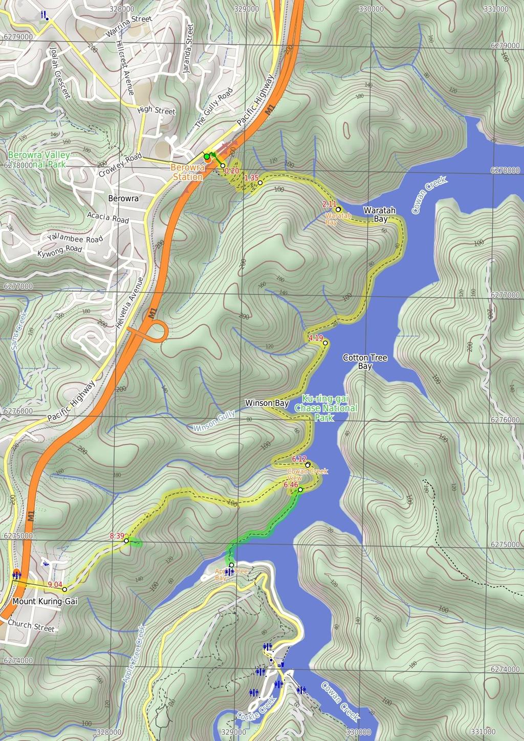
1 Berowra to Mt Kuring-gai 4 hrs 30 mins 9.4 km One way Hard track 4 551m From the ridges above Cowan Creek, this walk takes in some great lookouts (especially around Mt Kuringgai) as well as enjoying an extremely pleasant bush track along the creek. Easily accessible by public transport, this track gives walkers a good taste of what Ku-ring-gai Chase National Park has to offer. Be sure to spare some time for a dawdle around the bays on Cowan Creek. 213m 1m Ku-ring-gai Chase National Park Maps, text & images are copyright wildwalks.com Thanks to OSM, NASA and others for data used to generate some map layers.

2 Waratah Bay Before You walk Waratah Bay sits on the eastern extent of Cowan Waters east of Berowra. The bay is home to a rusting metal boat hull, this boat marks the spot where the Edward Windybank and his family once worked and lived. Edward Windybank worked on the construction nearby railway line from 1886 to 87. Windybank also named the bay and acquired a life-long lease to use it. It seems that he built a small home, boat shed and a narrow road up the hill. Windybank operate a boat building a hire business on site Bushwalking is fun and a wonderful way to enjoy our natural places. Sometimes things go bad, with a bit of planning you can increase your chance of having an ejoyable and safer walk. Before setting off on your walk check Cowan Creek View Cowan Creek View, is a timber platform lookout on Cowan Creek. The lookout is on the northern side of a headland and provide great views down along Cowan Creek. This is a great place to rest and enjoy the water views. Apple Tree Bay Apple Tree Bay, in Ku-Ring-Gai Chase national park, has a popular boat ramp for accessing Cowan creek and plenty of parking. The area has kiosk, electric BBQ's, picnic benches, toilets, drinking water, garbage facilities, and shade provided by trees. If you are after a quiet spot, head to the western end (away from the boat ramp, past the BBQ's), just beyond the car park, to a lovely clearing by the water. The area is closed between sunset and sunrise. The kiosk/cafe is open on weekend and services hot and cold drinks, ice creams and some hot food. 1) Weather Forecast (BOM Metropolitan District) 2) Fire Dangers (Greater Sydney Region) 3) Park Alerts (Ku-ring-gai Chase National Park, Berowra Valley National Park) 4) Research the walk to check your party has the skills, fitness and equipment required 5) Agree to stay as a group and not leave anyone to walk solo Think before you TREK The 'Think before you TREK' program developed by NSW Police & NPWS promotes the benefits of planning ahead for your bushwalking trip by using an easy to remember acronym: adequate supplies of food, water, navigation and first T Take aid equipment. your planned route and tell friends and family when R Register you expect to return. beacon (PLB's) should be carried on walks with E Emergency significant gaps in mobile coverage (check terrain profile). to your planned route and follow the map and walking K Keep trails. Topo Maps The maps provided on wildwalks are helpful, but there are times where you may need maps covering a broader area. Maps that cover this walk include; 1: Map Series:91304S HORNSBY, 91304N COWAN 1: Map Series:CMA Ku-ring-gai Chase National Park Tourist Map 1: Map Series:9130 SYDNEY Grade This walk has been graded using the AS The overall grade of the walk is dertermined by the highest classification along the whole track. 4 Grade 4/6 Hard track Length 9.4 km One way Time 4 hrs 30 mins Quality of track Rough track, where fallen trees and other obstacles are likely (4/6) Signs Directional signs along the way (3/6) Experience Required Some bushwalking experience recommended (3/6) Weather Storms may impact on navigation and safety (3/6) Infrastructure Limited facilities (such as cliffs not fenced, significant creeks not bridged) (4/6)
3 Are you ready to have fun? Please ensure you and your group are well prepared and equipped for all possible hazards and delays. Check park closures, weather information and Fire Danger Rating before setting out. Optional side trips and alternate routes noted are not included in this walks overall grade, length or time estimate. Please allow extra time for resting and exploring areas of interest. The authors, staff and owners of wildwalks take care in preparing this information but will not accept responsibility for any inconvenience, loss or injury you may experience. Please take care, have fun - Happy Walking. Getting there You can get to Berowra Railway Station (gps: , ) by car or train. Train: Most trains stop at Berowra and services run regularly about every 30mins during peak and hourly off peak. The station is on the Newcastle line between Hornsby and Wyong so access from the North or South is easy. Car: The train station is on the Pacific Hwy about 10 km north of Hornsby. There is parking in the area (although this can fill up mid week with commuters). Parking is permitted in many of the back streets. You can get back from Mt Kuring-gai Railway Station (gps: , ) by car or train. Train: To get away from Mt Ku-ring-gai Train Station trains run approximately every hour along the Newcastle Line. This line goes both ways between Hornsby and Wyong. Car: From Mt Ku-ring-gai Station it is possible to get away to either Hornsby to the South or Brooklyn and the Central Coast in the North using the Pacific Hwy. Find up to date and more information inlcuding; travel directions, weather, park closures and walker feedback at 0 Berowra Railway Station (200 m 3 mins) From the front of Berowra Station, this walk follows the footpath between the Pacific Highway and railway line, whilst keeping the highway to your left. After about 50m this walk comes to 'Berowra Parade' marked with a large 'Harbour to Hawkesbury' information sign and map. Here the walk turns right and follows the little used road down over railway bridge then around the green metal gate to cross over the F3 on a large concrete bridge. On the other side of the freeway this walk comes to a small clearing marked with a large 'Ku-ring-gai Chase National Park - Berowra Track' sign. 0.2 End of the old Berowra Parade (1.2 km 29 mins) Veer right: From the clearing, this walk follows the track beside the large 'Ku-ring-gai Chase National Park - Berowra Track' sign heading directly away from the freeway. The track is initially slightly overgrown and leads over a series of concrete drains. The track then leads gently down through a tall casuarina and eucalypt stand for about 30m to come to the edge of an unfenced cliff, with filtered valley views. Here the walk turns left and leads gently down along the clear track and beside a long rock wall (on your left) for about 150m to a sharp right hand bend. From here the track becomes a little steeper and continues through a series of 9 more hairpin bends for 800m becoming moderately steep and passing through a grass tree forest to come beside Waratah Gully creek. Here the track flattens out and heads down through the canyon like gully for 100m then down some stone steps to the Waratah Gully creek crossing. The walk crosses the slippery sandstone creek bed at the site of an old bridge to find a small constructed sandstone buttress on the far side. This creek may become impassable after heavy or prolonged rain Waratah Gully Crossing (760 m 15 mins) Continue straight: From the sandstone buttress on the south side of Waratah Creek, this walk follows the clear and mostly flat track down through the steep sided canyon like gully, keeping the creek steeply below and to your left. After passing through the dense moist forest for about 500m the rocky track leads over an exposed section of old pipes then 70m later the track comes to the start of Waratah Bay. Here the rocky track continues to lead beside the bay, keeping the water to your left for 80m to pass a 'No Camping' and a 'Gas fires only' sign. The walk now climbs up and over a short rocky rise for about 35m to come back to the waters edge beside the rusted steel skeleton of a boat Waratah Bay Waratah Bay sits on the eastern extent of Cowan Waters east of Berowra. The bay is home to a rusting metal boat hull, this boat marks the spot where the Edward Windybank and his family once worked and lived. Edward Windybank worked on the construction nearby railway line from 1886 to 87. Windybank also named the bay and acquired a life-long lease to use it. It seems that he built a small home, boat shed and a narrow road up the hill. Windybank operate a boat building a hire business on site 2.11 Waratah Bay (2.1 km 53 mins) Continue straight: From beside the rusty remnants of Windybank boat, this walk follows the track along the foreshore keeping the water to your left. The track leads over a small rise for about 120m to come to a set of old peers that once supported the Windybank's boat shed. There are other remnant of their home in the area. The rocky track continues to undulate along the southern shoreline of Waratah Bay for about 400m passing some large boulders to where the track bends right, following the shoreline, to come alongside Cowan Creek. This walk follows the rocky track as it leads upstream along the western shore of Cowan Creek for about 50m to pass a deep but short sandstone overhang (on your right). Continuing to undulating along the rocky shoreline, this walk heads through the bracken ferns and tall forest for 500m to cross a shallow rocky gully. About 180m later this walk veers right to follow the formal track up the timber steps, over a rise to continue long the shoreline over a few more rises for 300m before crossing a deep moist gully just beyond a large sandstone cave, just inside the northern headland of Lords Bay. The walk now leads along the northern shore into Lords bay for 250m to cross the usually small creek and densely forest gully at the apex of Lords Bay. About 60m later the track crosses another usually small creek on the slippery sandstone rocks to then follow the clear track along the southern shoreline of Lords bay for 200m to a small rock platform on the southern headland of Lords Bay Lords Bay headland (1.9 km 49 mins) Continue straight: From the small rock platform on the southern headland of Lords Bay, this walk follows the track along foreshore keeping the water to your left for 350m to then head alongside a natural rock wall (on your right) and a shorter wall (on your left). From here the walk continues along the foreshore for 400m to cross the rocky apex of Winson Gully bay then along the southern foreshore of this bay for just shy of 200m to an unfenced flat rock with great views down Cowan Creek. This walk now continues to follow the track for 200m past a small cave to the where the track bends right at the southern headland of Winson Gully bay to continue along side Cowan Creek for 250m to pass a section of track where large sandstone boulders have been placed to stabilise the shoreline. The track then bends right to follow the shoreline into another bay then along north shore of this bay for 300m to cross the usually shallow but wide (unnamed) creek flowing over sandstone platform and around boulders. Now this walk follows the track out of the bay along the southern shoreline past a section where more large rocks have been placed to protect the track then up a few steps to a timber boardwalk and viewing platform on Cowan Creek Cowan Creek View Cowan Creek View, is a timber platform lookout on Cowan Creek. The lookout is on the northern side of a headland and provide great views down along Cowan Creek. This is a great place to rest and enjoy the water views Cowan Creek View (330 m 8 mins) Continue straight: From the viewing platform, this walk heads along the timber boardwalk keeping Cowan Creek to your left. The boardwalk bends right where the walk then heads up some steps and follows the rocky track as it undulates along the shoreline for 150m to pass close to a green channel marker. From here the walk continues along shoreline for just over 160m to then head up some timber steps and come to a signposted intersection at the bottom of the the signposted 'Mt Ku-ring-gai Track' (up to your right) Optional sidetrip to Apple Tree Bay (940 m 26 mins) Continue straight: From the intersection, this walk follows the clear track along the shoreline, keeping the water to your left. After about 40m this walk comes to a constructed stone wall and series of disused stone steps (on your right). This is the site of the Woodnutts Boatshed that was built in The rusting water tank and a few other relics remain. From here this walk continues along the shore line for just over 300m veering right a few times to pass over small rises using some timber steps to then cross two small rock gully and grove of sassafras. From this second gully the walk continues for 200m along side Cowan creek to here the now mostly flat track tends right (still on the shoreline) and into Apple Tree Bay. The track then becomes rocky and leads up and down a series of stone steps for about 100m to find small fenced clearing and picnic area where a sign points back along the 'Berowra Track'. Here the walk turns left and crosses Apple Tree Creek on the timber bridge to find a sheltered 'Information' sign on the other side. Now the walk leads past the top of the boat ramp and wanders across the car park just shy of 100m to find the kiosk at and 'Welcome to Apple Tree Bay' sign at the main entrance to the parking area. At the end of this side trip, retrace your steps back to the main walk then Turn left Apple Tree Bay Apple Tree Bay, in Ku-Ring-Gai Chase national park, has a popular boat ramp for accessing Cowan creek and plenty of parking. The area has kiosk, electric BBQ's, picnic benches, toilets, drinking water, garbage facilities, and shade provided by trees. If you are after a quiet spot, head to the western end (away from the boat ramp, past the BBQ's), just beyond the car park, to a lovely clearing by the water. The area is closed between sunset and sunrise. The kiosk/cafe is open on weekend and services hot and cold drinks, ice creams and some hot food Int of Mt Kuring-gai and Berowra Tracks (1.9 km 49 mins) Turn right: From the intersection, this walk follows the 'MT Ku-ring-gai Track' sign up the rock and timber steps and past the small overhang. The track leads fairly steeply up for 80m to then bend sharply right and continue fairly steeply for another 200m to pass a natural rock wall (on your left). Just 20m past this wall the track comes to a small flat area with good views over Cowan Creek. Here the walk continues more gently uphill along the rocky ridge line for 300m where the track completely flattens out to pass along the side of a small hill (on your left). Over the next 600m the track leads down across a saddle then up along the ridge to bend right onto an exposed rock platform. From there the sandy track soon bends left again to follow the ridge uphill for 100m to pass a small sandstone overhang then continue up a long set of stone steps where the sandy track mostly flattens out again. Soon the track starts heading up more stone steps for about 400m to pass between a large boulder (on your left) and along rock wall (on your right). At the end of this rock wall the track bends right and leads up the stone steps through the cleft in the rock where the then mostly flat wide sandy track leads gently uphill for 250m to find a three-way intersection marked with a NPWS arrow post Optional sidetrip to Apple Tree Bay Viewpoint (110 m 2 mins) Turn left : From the intersection, the walk heads east away

4 from the main trail to follow the wide sandy track gently downhill. The track begins to narrow and after about 100m the now rocky track comes to an unfenced rock platform with good views down over Apple Tree Bay and down along Cowan Creek valley. At the end of this side trip, retrace your steps back to the main walk then Veer left Int of Lookout and Mt Kuringai Tracks (650 m 11 mins) Continue straight: From the intersection, this walk heads away from the face of the face of the NPWS arrow post to head south west over a small rise and along the sandy management trail. The trail passes through open wooded forest for just over 600m to pass a 'Ku-ring-gai Chase National Park - Mt Kuring gai Track' sign as the trail bends right where this walk heads around the green metal National Park gate. Here the walk heads past a few houses to find the intersection of 'Harwood Ave' and 'Young St' (Mt Kuring-gai) Corner of Harwood Avenue and Young Street (400 m 8 mins) Continue straight: From the corner of Harwood Avenue and Young Street, this walk follows Harwood Ave downhill along the footpath. The footpath then leads up past a 'Seaview St' and across 'Low St' to continue to the end of Harwood Ave to find a footbridge. Here the walk crosses the the F3 freeway using the caged foot bridge to head down the steps into a concrete tunnel. Part way through the tunnel this walk comes to an intersection at the bottom of the steps at Mt Kuring-gai Railway Station. Here there is a sign that points back to 'Mt Ku-ring-gai Walking Track'
5
6 Summary navigation sheet for the Berowra to Mt Kuring-gai km From 0.00 Berowra Railway Station , (GR Cowan, ) End of the old Berowra Parade , (GR Cowan, ) Waratah Gully Crossing , (GR Hornsby, ) Waratah Bay , (GR Hornsby, ) Lords Bay headland , (GR Hornsby, ) Cowan Creek View , (GR Hornsby, ) Int of Mt Kuring-gai and Berowra Tracks , (GR Hornsby, ) Int of Mt Kuring-gai and Berowra Tracks , (GR Hornsby, ) Int of viewpoint and Mt Kuring-gai Tracks , (GR Hornsby, ) Int of Lookout and Mt Kuringai Tracks , (GR Hornsby, ) Corner of Harwood Avenue and Young Street , (GR Hornsby, ) Powered by TCPDF ( Up/Dwn Length Initial directions (Use full tracknotes and maps for more detail) m 3 mins 1.2 km 29 mins 760 m 15 mins 2.1 km 53 mins 1.9 km 49 mins 330 m 8 mins 940 m 26 mins 1.9 km 49 mins 110 m 2 mins 650 m 11 mins 400 m 8 mins From the front of Berowra Station, this walk follows the footpath between the Pacific Highway and railway line, whilst keeping the highway to your left. Veer right: From the clearing, this walk follows the track beside the large 'Ku-ring-gai Chase National Park Berowra Track' sign heading directly away from the freeway. Continue straight: From the sandstone buttress on the south side of Waratah Creek, this walk follows the clear and mostly flat track down through the steep sided canyon like gully, keeping the creek steeply below an... Continue straight: From beside the rusty remnants of Windybank boat, this walk follows the track along the foreshore keeping the water to your left. Continue straight: From the small rock platform on the southern headland of Lords Bay, this walk follows the track along foreshore keeping the water to your left for 350m to then head alongside a natural rock wall (... Continue straight: From the viewing platform, this walk heads along the timber boardwalk keeping Cowan Creek to your left. Optional sidetrip to Apple Tree Bay. Continue straight: From the intersection, this walk follows the clear track along the shoreline, keeping the water to your left. Turn right: From the intersection, this walk follows the 'MT Ku-ring-gai Track' sign up the rock and timber steps and past the small overhang. Optional sidetrip to Apple Tree Bay Viewpoint. Turn left : From the intersection, the walk heads east away from the main trail to follow the wide sandy track gently downhill. Continue straight: From the intersection, this walk heads away from the face of the face of the NPWS arrow post to head south west over a small rise and along the sandy management trail. Continue straight: From the corner of Harwood Avenue and Young Street, this walk follows Harwood Ave downhill along the footpath.
Sid Pulsford Walk. 175m. 33m. 1 hr 45 mins 4.1 km One way. Hard track 118m. Gosford LGA
 Sid Pulsford Walk 1 hr 5 mins.1 km One way Hard track 118m Sid Pulsford Walk explores the ridge top of Kincumber Mountain, from Honeman's Rock to Green Point. The walk mostly follows wide management trails.
Hunters Hill to Epping Road
 Hunters Hill to Epping Road 2 hrs 30 mins 5.5 km One way Moderate track 154m An enjoyable walk through lower sections of the Lane Cove National Park, this walk features plenty of mangroves next to the
Hornsby Blue Gum Walk
 Hornsby Blue Gum Walk 3 hrs Hard track 6.7 km Circuit 4 374m This delightful loop is one of the prettiest and most popular walks in the Hornsby area. Going from an environment of ferns and clear bushland
Wentworth Falls Conservation Hut Loop
 Wentworth Falls Conservation Hut Loop 3 hrs Hard track 6.7 km Circuit 4 341m This scenic walk from Wentworth Falls Station, winds along the Nature Trail to Conservation Hut, then drops into the magnificent
Morgans Creek to Padstow
 Morgans Creek to Padstow 2 hrs 45 mins 8 km One way Moderate track 3 144m This pleasant walk starts from the Morgans Creek park, at Henry Lawsons Drive, and follows the Georges River past the Boomerang
Echo Point to Leura Forest via Three Sisters and Giant Stairs loop
 Echo Point to Leura Forest via Three Sisters and Giant Stairs loop 3 hrs 3.8 km Circuit Hard track 512m This walk starts from the popular Echo Point, in Katoomba, and winds down to the base of the Three
Sphinx, Warrimoo and Bobbin Head tracks
 Sphinx, Warrimoo and Bobbin Head tracks 4 hrs 9.6 km Circuit Moderate track 499m This great walk starts at the Sphinx Memorial and loops around via Cowan Creek, exploring diverse environments as it changes
De Burgs Bridge to Thornleigh station
 De Burgs Bridge to Thornleigh station 3 hrs 45 mins 9.7 km One way Hard track 4 363m This walk follows a section of the Great North Walk, starting from De Burghs bridge. The walk winds north west, through
Currie Rd to Davidson Park
 Currie Rd to Davidson Park 3 hrs 7.2 km One way Moderate track 28m Starting at Currie Rd in Forestville, this walk follows Middle Harbour to Davidson Park, under Roseville Bridge. There are two optional
Sphinx to Mt Kuring-gai
 Sphinx to Mt Kuring-gai 4 hrs 45 mins 1.7 km One way Hard track 673m This walk starts at the Sphinx War Memorial and follows some well maintained and popular walking tracks down to Cowan Creek. Enjoy the
Little Digger Track to Davidson Reserve and Lyrebird Circuit
 Little Digger Track to Davidson Reserve and Lyrebird Circuit 4 hrs 3 mins 11.5 km One way Hard track 4 47m Exploring both the eastern and western sides of Middle Harbour Creek, this walk follows the Little
The Foreshore Walk. 24m. 1m Lake Macquarie LGA. 1 hr 15 mins 2.9 km One way. Hard track 81m
 The Foreshore Walk 1 hr 15 mins 2.9 km One way Hard track 81m This walk traverses the coastline of the Green Point reserve. By following a variety of tracks and occasionally traveling inland through eucalyptus
Wattamolla to Big Marley Beach
 Wattamolla to Big Marley Beach 4 hrs 10.4 km Circuit Moderate track 4m This walk is an excellent loop which takes in both the coast and the heathy inland of Royal National Park. Nearly the whole walk has
Campbell Drive to Snapper Point
 Campbell Drive to Snapper Point 1 hr 45 mins 4.2 km One way Experienced only 135m This walk follows the Coast Track to Frazer Beach, along the Geebung and (overgrown) Grass Tree Tracks. From the northern
Govetts Leap Loop. 1065m. 909m Blue Mountains National Park. 4 hrs 30 mins 8.7 km Circuit. Hard track 380m
 Govetts Leap Loop 4 hrs 30 mins 8.7 km Circuit Hard track 380m This walk, from Blackheath Train Station, is a fantastic way to see some of the iconic areas of the Blue Mountains in the Blackheath area.
Wallarah Coastal Walk
 Wallarah Coastal Walk 3 hrs 8.3 km Return Hard track 247m This walk starts at Caves Beach and travels south along the coastline, until reaching the Pinney s Headland Lookout. There are many opportunities
Popes Glen, Pulpit Rock, Govetts Leap and Braeside Walk
 Popes Glen, Pulpit Rock, Govetts Leap and Braeside Walk 8 hrs Hard track 13.6 km Circuit 4 1068m This large circuit walk, from Popes Glen to Pulpit Rock, Govetts leap and along the Braeside Track, passes
Epping to Pennant Hills Station (via Lane Cove River)
") Epping to Pennant Hills Station (via Lane Cove River) 3 hrs 5 mins 8.4 km One way Hard track 249m This walk, from Epping to Pennant Hills Station, is a great way to see the upper Lane Cove River Valley.
Epping to Pennant Hills Station (via Lane Cove River) 3 hrs 5 mins 8.4 km One way Hard track 249m This walk, from Epping to Pennant Hills Station, is a great way to see the upper Lane Cove River Valley.
Carrington Park to Leura Forest and pass loop
 Carrington Park to Leura Forest and pass loop 3 hrs Hard track 4.8 km Circuit 4 674m This walk is a fantastic way to see Leura Forest. The walk descends from Carrington Park, visiting Leura Forest and
Little Digger Track. 68m. 1 Hr 2.2 km One way. Moderate track 93m. Moores Creek Reserve
 Little Digger Track Hr 2.2 km One way Moderate track 93m This walk follows Moores Creek through several reserves in east Roseville and East Lindfield. The track is named after Australia's 7th Prime Minster,
Epping to Eastwood Station (via Lane Cove River)
") Epping to Eastwood Station (via Lane Cove River) hrs 45 mins 10.2 km One way Moderate track 189m Epping to Eastwood, via Lane Cove River, is the longer route through the bush between the stations. This
Epping to Eastwood Station (via Lane Cove River) hrs 45 mins 10.2 km One way Moderate track 189m Epping to Eastwood, via Lane Cove River, is the longer route through the bush between the stations. This
The Basin Track and Mackerel Track
 The Basin Track and Mackerel Track 3 hrs 5.9 km Circuit Hard track 226m This walk is a great way to see some popular areas in Ku-ring-gai Chase National Park. The walk from West Head Rd travels to The
Mackerel Beach, West Head Loop
 Mackerel Beach, West Head Loop 5 hrs 8.6 km Circuit Hard track 422m The Mackerel Beach, West Head Loop is a walk which explores a large part of the West Head. The journey starts and finishes with a ferry
Waterfall to Heathcote
 Waterfall to Heathcote 5 hrs Hard track 10.8 km One way 4 467m This walk explores the heart of Heathcote National Park, and is easily accessed with a train station at either end. Although relatively close
Mackerel Beach and Resolute Loop
 Mackerel Beach and Resolute Loop 3 hrs 5.4 km Circuit Hard track 384m This walk is another great walk in Ku-ring-gai Chase National Park, accessed by ferry. From the Mackerel Beach wharf, this walk uses
Heathcote to Engadine via Audley
 Heathcote to Engadine via Audley 6 hrs 3 mins 5 km One way Hard track 4 635m Covering a large section of central Royal National Park, this walk goes through the heath and scrub along a well managed and
Katoomba Falls Circuit
 Katoomba Falls Circuit hr 5 mins.5 km Circuit Hard track 59m For those looking for a walk involving more than simple boardwalk, this trail winding through the temperate rain forest could be just the thing.
Middle Harbour Creek Loop
 Middle Harbour Creek Loop 5 hrs 45 mins 15.1 km Circuit Experienced only 5 570m This walk explores the upper reaches of Middle Harbour Creek, starting and ending at the great parklands at Davidson Park,
Teralba to Charlestown Park track head
 Teralba to Charlestown Park track head 4 hrs 30 mins 13.3 km One way Moderate track 3 220m This section of the Great North Walk starts from the Teralba train station and winds down and around the edge
Callicoma Loop. 174m. 98m. 2 hrs. Hard track 5.1 km Circuit. 153m
 Callicoma Loop 2 hrs Hard track 5.1 km Circuit 153m This great circuit walk passes through some really nice forest around the fringe of Cherrybrook. Highlights of the walk include some beautiful rock overhangs
Patonga to Woy Woy. 5 hrs 45 mins 15.5 km One way. Hard track. 497m
 Patonga to Woy Woy 5 hrs 45 mins 15.5 km One way Hard track 4 497m This walk explores a variety of environments from the shore line and coastal cliffs near Patonga, to the dry, rocky and open ridge line.
Balmoral Beach to The Spit
 Balmoral Beach to The Spit 2 hrs 30 mins.3 km One way Hard track 85m This walks follows the coast from Balmoral to the Spit and across Spit Bridge. There are some alternate tracks to consider at high-tides,
Green Point Circuit Walk
 Green Point Circuit Walk 3 hrs 7.7 km Circuit Hard track 269m This walk visits all of the popular locations in Green Point Reserve, as well as some of the lesser-visited areas inland. Taking in Sea Eagle
Under and Over Cliff Walk
 Under and Over Cliff Walk 4 hrs 9.4 km Circuit Moderate track 576m This walk from Wentworth Falls Station is a fantastic way to see a large majority of the Wentworth Falls cliffline. The track winds under
Scenic World to Echo Point
 Scenic World to Echo Point 1 hr 15 mins 2.1 km One way Moderate track 192m This is one of the most popular tourist walks in the Katoomba area. The walk follows the cliffs along a well maintained and signposted
Bouddi Coastal Walk. 5 hrs. Hard track 8.1 km One way. 364m
 Bouddi Coastal Walk 5 hrs Hard track 8.1 km One way 4 364m This is one of the longer walks in the Bouddi National Park and it is rich in scenery. The walk follows the coastline with many side trips to
Dead Horse Gap Loop track
 Dead Horse Gap Loop track 4 hrs 30 mins Hard track 9.8 km Circuit 144m 4 This walk starts with a ride up the Kosciuszko Express Chairlift. There is an opportunity to eat at Australia's highest restaurant,
Rail to River Walk. 3 hrs. Hard track 7.5 km Circuit. 222m
 Rail to River Walk 3 hrs Hard track 7.5 km Circuit 4 222m This walk is a great one from Chatswood Station to the Lane Cove River National Park. The walk descends through the vegetated bushland which fills
De Burghs Bridge to Fullers Bridge
 De Burghs Bridge to Fullers Bridge 2 hrs 3 mins Hard track 6 km One way 2m 4 Following the Lane Cove River, this walk mostly follows a section of the Great North Walk and is well maintained and signposted.
Wentworth Falls Station Loop (Undercliff Walk)
") Wentworth Falls Station Loop (Undercliff Walk) 4 hrs 3 mins Hard track 8.9 km Circuit 658m 4 This walk passes some stunning waterfalls and views into the Jamison Valley, following the cliff edges around
Wentworth Falls Station Loop (Undercliff Walk) 4 hrs 3 mins Hard track 8.9 km Circuit 658m 4 This walk passes some stunning waterfalls and views into the Jamison Valley, following the cliff edges around
Thornleigh to Hornsby
 Thornleigh to Hornsby 4 hrs Hard track 10.2 km One way 4 526m Starting at Thornleigh station you walk through suburban streets for a short while before diving into the bush at the southern end of Berowra
Rail to River and Stringybark Creek Reserve Walk
 Rail to River and Stringybark Creek Reserve Walk 4 hrs Hard track 11.2 km Circuit 4 302m This walk begins in the busy city of Chatswood and soon enters the nearby bushland around the Lane Cove River. The
Upper Rumbalara circuit
 Upper Rumbalara circuit 1 hr 30 mins 3.3 km Circuit Hard track 176m A great circuit walk, covering most of the walking tracks and sights in the upper section of the Rumbalara Reserve. There is some really
Dubbo Gully and Ten Mile Hollow Circuit (via Clares Bridge)
") Dubbo Gully and Ten Mile Hollow Circuit (via Clares Bridge) 2 Days Hard track 24.3 km Circuit 4 1117m This two day (or ten hour) walk follows several historic roads, now closed to traffic. Starting with
Dubbo Gully and Ten Mile Hollow Circuit (via Clares Bridge) 2 Days Hard track 24.3 km Circuit 4 1117m This two day (or ten hour) walk follows several historic roads, now closed to traffic. Starting with
National Pass from Wentworth Falls to Conservation Hut
 National Pass from Wentworth Falls to Conservation Hut 3 hrs Hard track 3.6 km One way 739m Starting at Wentworth Falls picnic area, this scenic and historic walk explores many waterfalls, lookouts and
Epping to Gordon Station
 Epping to Gordon Station 4 hrs 15 mins 11.7 km One way Hard track 4 365m This walk, from Epping Station to Gordon Station, passes below the homes which sit on the hills high above the Lane Cove River.
Bobbin Head Loop. 166m. 0m Ku-ring-gai Chase National Park. 5 hrs 12.9 km Circuit. Hard track 619m
 Bobbin Head Loop 5 hrs 12.9 km Circuit Hard track 619m This great circuit walk enjoys a variety of landscapes in Ku-ring-gai Chase National Park. The walk starts at the historic Sphinx war memorial and
Federal Pass Walking Track
 Federal Pass Walking Track 5 hrs Hard track 8 km One way 4 989m This classic trail follows along the base of the cliffs from Leura to the Golden Stairs, passing many of the more popular sights of the Katoomba
Spit Bridge to Middle Head Forts
 Spit Bridge to Middle Head Forts 2 hrs 30 mins 6.3 km One way Hard track 4 181m This scenic walk takes you from the Spit Bridge, along the coast to explore the Middle Head Forts. There are a few alternate
Blackheath Station to Junction Rock Loop (via Grand Canyon and Popes
 Blackheath Station to Junction Rock Loop (via Grand Canyon and Popes 8 hrs 30 mins 18.2 km Circuit Hard track 4 1254m This circuit starts in Blackheath and heads down into the Grand Canyon and Rodriguez
Lane Cove Tourist Park River Circuit
 Lane Cove Tourist Park River Circuit 5 hrs 12 km Circuit Hard track 383m This walk follows a large section of Lane Cove River. The walk follows the Riverside Walking track up the Lane Cove River to De
Taronga Wharf to Chowder Bay
 Taronga Wharf to Chowder Bay 2 hrs 4.4 km One way Moderate track 246m Starting at Taronga Wharf, this walk passes many icons of Sydney, including Taronga Zoo, HMAS Sydney Mast, Chowder Bay. The walk also
Woolwich Wharf to Boronia Park
 Woolwich Wharf to Boronia Park 2 hrs 5.8 km One way Moderate track 175m Going through the streets of Hunters Hill, this walk is on the first segment of the Great North Walk. The majority of the walk is
Roseville to Macquarie Park
 Roseville to Macquarie Park 3 hrs 3 mins 8.8 km One way Hard track 4 29m This walk starts at Roseville station and explores the streets and alleyways of Roseville before joining the main spine of the Great
Glenbrook and Euroka Circuit
 Glenbrook and Euroka Circuit 2 Days 16.6 km Circuit Experienced only 790m This two day circuit, returning to Glenbrook Station, is a scenic walk which passes many of the tourist attractions within the
Hermitage Foreshore Track
 Hermitage Foreshore Track 1 Hr 2.2 km One way Moderate track 123m The Hermitage Foreshore Walk is a wonderful way to explore Sydney Harbour from the perspective of South Head. This walk starts from Nielsen
Wentworth Falls Loop. 893m. 665m. 6 hrs 10.2 km Circuit. Hard track 1093m. Blue Mountains National Park
 Wentworth Falls Loop 6 hrs 1.2 km Circuit Hard track 193m This is a great walk, both in size and spectacular views. The walk makes its way from Wentworth Falls train station and drops off the plateau,
Echo Point to Leura Forest Circuit
 Echo Point to Leura Forest Circuit 3 hrs 4.8 km Circuit Hard track 588m Forming a circuit around the cliffs and then the valley floor, this is a walk more then capable of convincing a walker of the beauty
Wentworth Falls Station Loop
 Wentworth Falls Station Loop 5 hrs 3 mins 9.5 km Circuit Hard track 4 13m The Wentworth Falls Station Loop takes in most of the upper tracks around Wentworth Falls. There are many scenic views near the
Gordon to Chatswood Station
 Gordon to Chatswood Station 4 hrs 30 mins 12.2 km One way Hard track 4 381m This walk is a great way to get into the bush without being far from civilisation. The walk wanders through untouched valleys
North Ryde Fairyland circuit
 North Ryde Fairyland circuit 2 hrs 30 mins Hard track 6.9 km Circuit 193m 4 Starting at North Ryde train station this walk explores a stretch of the Lane Cove River, visiting the historic Fairlylands Pleasure
Gosford to Lisarow. 202m
 Gosford to Lisarow 4 hrs 3 mins Hard track 11.3 km One way 4 479m This walk is a great way to explore the ridge-top bushland between Gosford and Lisarow. Passing through Rumbalara and Katandra Reserves,
Charlestown Park trackhead to Newcastle station
 Charlestown Park trackhead to Newcastle station 5 hrs 30 mins 12.1 km One way Hard track 4 287m This section of the Great North Walk starts from the Charleston Park track head and winds through the streets
Cape Banks Circuit. 50m. 2m Botany Bay National Park. 3 hrs 7.3 km Circuit. Hard track 190m
 Cape Banks Circuit 3 hrs 7.3 km Circuit Hard track 19m This Cape Banks Circuit has a lot to offer and is thoroughly recommended. The walking travels over beaches, through coastal forest and across exposed
Faulconbridge to Blaxland
 Faulconbridge to Blaxland 2 Days Experienced only 15.2 km One way 5 693m This two-day walk, or very solid one-day walk, takes you from station to station, through lush, scenic forest in the lower Blue
Rumbalara Explorer. 158m. 5m Rumbalara Reserve. 2 hrs 45 mins 6.1 km Circuit. Hard track 326m
 Rumbalara Explorer 2 hrs 5 mins 6.1 km Circuit Hard track 326m Pretty well the grand tour of the Rumbalara Reserve, this walk takes in much of the great scenery the reserve has to offer. The walk covers
Bouddi Ridge and Coastal Walk
 Bouddi Ridge and Coastal Walk 2 Days Hard track 27 km Circuit 4 126m This overnight walk takes in the majority of the magnificent Bouddi National Park. The walk starts from the pleasant Putty Beach camping
Chatswood to Epping Station
 Chatswood to Epping Station 6 hrs Hard track 16.3 km One way 4 533m This walk, from Chatswood to Epping, is a long but enjoyable walk along the Lane Cove valley. The walk mostly follows the Lane Cove River
The Coast Track. 2 Days. Hard track 27.4 km One way. 1351m
 The Coast Track 2 Days Hard track 27.4 km One way 4 1351m Heading south, this walk covers the coastline of the Royal National Park and can truly only be described as amazing. With breathtaking coastal
Scenic world to Three Sisters Loop via Furber Steps
 Scenic world to Three Sisters Loop via Furber Steps 5 hrs 5.8 km Circuit Hard track 722m This walk starts from the popular Scenic World, in Katoomba, and winds down the Furber steps into the Jamison Valley,
Spit Bridge to Manly (Manly Scenic Walkway)
") Spit Bridge to Manly (Manly Scenic Walkway) 3 hrs 45 mins 9.1 km One way Moderate track 349m The Spit to Manly walk is a classic bushwalk on Sydney's Northern Beaches. The walk follows a well-maintained
Spit Bridge to Manly (Manly Scenic Walkway) 3 hrs 45 mins 9.1 km One way Moderate track 349m The Spit to Manly walk is a classic bushwalk on Sydney's Northern Beaches. The walk follows a well-maintained
Narrabeen Lagoon Trail (from Middle Creek)
") Narrabeen Lagoon Trail (from Middle Creek) 2 hrs 30 mins 8.6 km Circuit Very easy 1 105m The Narrabeen Lagoon Trail is a wonderful and accessible walk on the Northern Beaches of Sydney. The trail is used
Narrabeen Lagoon Trail (from Middle Creek) 2 hrs 30 mins 8.6 km Circuit Very easy 1 105m The Narrabeen Lagoon Trail is a wonderful and accessible walk on the Northern Beaches of Sydney. The trail is used
Taronga Zoo to Spit Bridge
 Taronga Zoo to Spit Bridge 5 hrs Hard track 1.4 km One way 4 41m This is a scenic and culturally rich walk with views over Sydney Harbour and many interesting heritage buildings along the way. The start
Manly to Seaforth Oval
 Manly to Seaforth Oval 5 hrs 45 mins 13.7 km One way Moderate track 3 624m This walk follows the Manly to Spit Scenic Walkway, then continues past The Spit Bridge to Seaforth Oval. The walk provides magnificent
Six Foot Track. 1212m
 Six Foot Track 3 Days 44.8 km One way Hard track 4 2066m This classic walk takes you from Katoomba to Jenolan Caves via a historic horse route. The walk travels mainly along well-maintained service tracks
Sydney to Thornleigh via Lane Cove Tourist Park
 Sydney to Thornleigh via Lane Cove Tourist Park 2 Days 33 km One way Hard track 4 1114m This overnight walk starts from the Obelisk in Macquarie Park, Sydney, at the official start of the Great North Walk.
Light to Light Walk 2 days
 Light to Light Walk 2 days 2 Days Hard track 3.9 km One way 4 794m Over two days, this classic walk explores the coast from Boyd Tower to the Green Cape Lighthouse in the south. Hegartys Bay Camp is over
ULTRA-TRAIL AUSTRALIA May 2018 COURSE DESCRIPTION AND COURSE NOTES
 ULTRA-TRAIL AUSTRALIA 100 19-20 May 2018 COURSE DESCRIPTION AND COURSE NOTES LEG 1 Scenic World (Start) to Narrow Neck (Checkpoint 1) Course Description: From the start, at the front entrance of Scenic
Beautiful Walks from the Blue Ball Inn
 Walk No. 7 COAST AND VALLEY WALK Countisbury, Glenthorne, County Gate, Brendon, Rockford and Wilsham 10 MILES APPROX. Walking time 5 hours approx. (not including breaks)> OS Sheet 64/74 Lynton and Lynmouth.
Start / Finish. Version 2
 Start / Finish Version 2 Gosford (Start) to Woy Woy Head South down Etna Street, crossing Henry Parry Drive, then Mann St, Gosford, where Etna St becomes Racecourse Road. Follow this road all the way
VELINDRE VALLEYS WALK FOR STEFFAN
 VELINDRE VALLEYS WALK FOR STEFFAN IMPORTANT INFORMATION FOR WALKERS AND MARSHALS 1 Table of Contents Key Contact Numbers:... 3 Timetable and locations... 4 T-shirts... 4 Important Advice for Walkers...
Winterfold Wood. point your feet on a new path. In Brief
 point your feet on a new path Winterfold Wood Distance: 8½ km=5¼ miles Region: Surrey Author: Schwebefuss Refreshments: Windmill Inn, Peaslake after the walk moderate walking with many gradients Date written:
Detailed maps, and portaging and camping information follow.
 Overview of Bain route. The launch site is at Davidson Lake, just before the Manitoba/Ontario border. You can do a loop if you leave a vehicle at Tulabi Lake (at the canoe route parking lot). The road
Calaveras Big Trees State Park--South Grove Loop
 Copyright 1999 by Jeff Robinson. You are free to use and reproduce this description for personal, not-for-profit, and not-forbusiness use. Any reproduction other than for personal use, including businesses,
Harbour Bridge to Taronga Zoo
 Harbour Bridge to Taronga Zoo 4 hrs 9.8 km One way Moderate track 389m On this walk, you will explore much of the foreshore linking Milsons Point Station to Taronga Zoo Ferry wharf. The walk is mostly
THE BECK STONE Backstone Beck on Ilkley Moor
 THE BECK STONE Backstone Beck on Ilkley Moor 1 Three different routes which take in the best of the lower slopes of Ilkley Moor, with bracken, heather, a tarn (a small mountain lake) and rushing streams.
VERN S CAMP from Minginui
 VERN S CAMP from Minginui Map: Kuratau, 1:50,000 V18 Refer Figures 1, 3, 4 and 5 GPS: Geodetic Datum 1949 Refer Figure 10a (Geographic) and 10b (NZ Grid) How to get to START: From the police station on
THE WELLDIGGERS ARMS, HESWORTH AND FITTLEWORTH TRAIL
 THE WELLDIGGERS ARMS, HESWORTH AND FITTLEWORTH TRAIL 5.5 miles Circular 3 hours 041017 Challenging Terrain A 300-year-old pub turned country-inn on the edge of the South Downs National Park, The Welldiggers
Times. S E S/Rd(E) Wakefield Road) Wakefield Rural Fire Brigade
 Wakefield Road) Wakefield Rural Fire Brigade") START On York Street, Teralba adjacent to Tulkaba Park Sports Pavilion (on leaving travel west on York Street) [EEP-1A] Position* Altitude Distance (km)* Trail S32 57.593 E151 36.520 21 0.5 0.5 S/Rd(E)
START On York Street, Teralba adjacent to Tulkaba Park Sports Pavilion (on leaving travel west on York Street) [EEP-1A] Position* Altitude Distance (km)* Trail S32 57.593 E151 36.520 21 0.5 0.5 S/Rd(E)
Coyote Buttes/The Waves
 Coyote Buttes/The Waves Ron Ross December 22, 2007 Coyote Buttes is located in the Paria Canyon-Vermilion Cliffs Wilderness just south of US 89 about halfway between Kanab, Utah and Page, Arizona. The
The North Pennines from near Langwathby
 3.6 Langwathby to Armathwaite Map panel?? Distance 12.7 miles (20.5 km) Terrain farm, woodland and riverside paths; some potentially muddy tracks; a few short sections of road Grade gently undulating Food
Approximate distance: 5.5 miles For this walk we ve included OS grid references should you wish to use them. Start. End
 Approximate distance: 5.5 miles For this walk we ve included OS grid references should you wish to use them. End 4 1 Start 3 2 N W E S Reproduced by permission of Ordnance Survey on behalf of HMSO. Crown
Hammer Vale and Linchmere Common
 point your feet on a new path Hammer Vale and Linchmere Common Distance: 9 km=5½ miles or 6 km=3¾ miles easy walking with one steep section Region: Hampshire, West Sussex Author: Botafuego Refreshments:
NEWLANDS CORNER AND ST MARTHAS
 NEWLANDS CORNER AND ST MARTHAS 10k CIRCULAR ROUTE 2½-3HRS GU4 8SE From Newlands Corner on the North Downs just outside Guildford, you can enjoy one of the most beautiful panoramas of quintessential English
Welsh Newton and Woodland
 Welsh Newton and Woodland This is a 8.2km miles (approx) walk which will take about 2.5 hours at a relaxed and leisurely pace. There are a few hills but no steep inclines. Start at Llangrove bus stop and
MAPS & WALK NOTES. DAY 2: Greenwich Wharf to Woolwich Wharf
 MAPS & WALK NOTES DAY 2: Greenwich Wharf to Woolwich Wharf Total Distance: 15.5km Time: Approximately 5 hours 30 mins five Sections Walk Notes in Section Name Length Time 2:1 Greenwich Wharf to Northwood
Fish Lake Team Relay Course Information 2016
 Fish Lake Team Relay Course Information 2016 Fish Lake Team Relay Course Information 2016 The Fish Lake Team Relay begins at Fish Lake Lodge on the shores of beautiful Fish Lake located in Sevier County,
Fish Lake Team Relay Course Information
 Fish Lake Team Relay Course Information Fish Lake Team Relay Course Information The Fish Lake Team Relay begins at Fish Lake Lodge on the shores of beautiful Fish Lake located in Sevier County, Utah. The
BEACH ACCESS INVENTORY 2014 Electoral Area A
 BEACH ACCESS INVENTORY 2014 Electoral Area A Site Inventory and report compiled by the Electoral Area A Parks, Recreation and Culture Commission members: Alec McPherson, Andrew Thornton, Angela Vincent,
3 3 Craigellachie to Ballindalloch
 3 3 Craigellachie to Ballindalloch Map panel 2 (inside back cover) Distance 12 miles 19 km Terrain disused railway trackbed Grade flat Food and drink Craigellachie, Aberlour and Ballindalloch (shop) Side-trips