Charlestown Park trackhead to Newcastle station
|
|
|
- Morris Greene
- 5 years ago
- Views:
Transcription


1 Charlestown Park trackhead to Newcastle station 5 hrs 30 mins 12.1 km One way Hard track 4 287m This section of the Great North Walk starts from the Charleston Park track head and winds through the streets and the bush to the Glenrock State Conservation Area. Following a section of the Yuelarbah management trail, this walk also heads to the coast and down to the beaches. From near Glenrock Lagoon, the walk heads north along the beaches passing Merewether baths, and all the way up Shepherds hill and down to Newcastle Station. This track also offers an alternate route through Glenrock, winding down through the scout training camp and out to the beaches. 102m 0m Glenrock State Conservation Area Maps, text & images are copyright wildwalks.com Thanks to OSM, NASA and others for data used to generate some map layers.

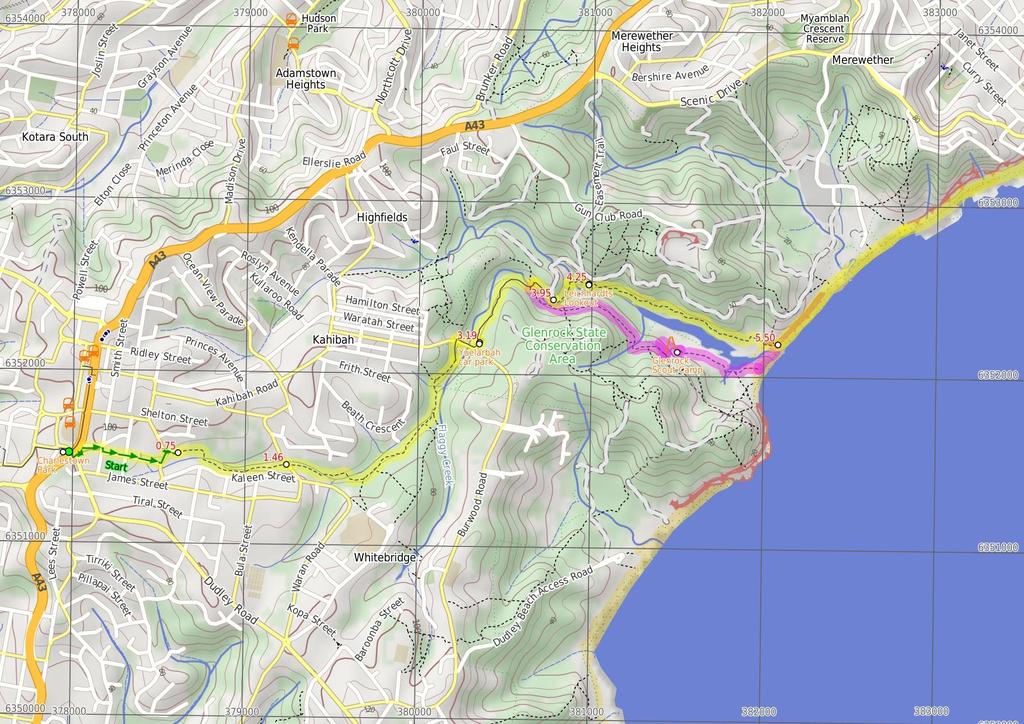
2 Charlestown Park Before You walk 'Charlestown Park', by the Pacific Highway in Charlestown, offers a picnic table, shelter, barbeque and war memorial. Charlestown Park is also known and signposted as 'Anniversary Grove'. Bushwalking is fun and a wonderful way to enjoy our natural places. Sometimes things go bad, with a bit of planning you can increase your chance of having an ejoyable and safer walk. Before setting off on your walk check Yuelarbah car park Yuelarbah car park on Burwood Rd, Kahibah is the starting point to a number of walks within the Glenrock State Conservation Area. From the car park tracks being for the Yuelarbah Track, Flaggy Creek, Little Flaggy Creek, Leichhardts Lookout and Burwood Beach walks. There is a sheltered information sign with historical and natural heritage information. Glenrock Scout Camp Glenrock Scout Camp, off Burwood road and within the Glenrock State Conservation Area is owned and operated by the Scouting Association of Australia. The scout camp is located by a beautiful lagoon and is close to the ocean. The scout camp is a great place to stop and relax, with self guided walks and nature trails available close by. At the scout camp there is a public telephone, locked toilets (available upon request), water and sheltered picnic tables. The scout camp has indoor accommodation available. The Overman's Cottage is a large simple cottage, with sleeping on mattress's on the floor and costs $80/day plus $8/person. Also available is the Mac Crumb Room, which is for adults only, has 8 bunks and has a self contained kitchen and toilet. The Mac Crumb Room costs $80/day plus $10/person. Camping is for Scouts only. Please contact the Hunter and Coastal Regional Office ( ) for information and to make a booking. The on site resident is also available ( ). More info. Leichhardts Lookout Leichhardts Lookout is within the Glenrock State Conservation Area. This lookout is a timber platform, looking east across Glenrock Lagoon and out to the ocean. Leichhardts Lookout is named after Ludwig Leichhardt a Prussian naturalist and explorer who, in 1842, described the view down into Glenrock Lagoon as well as other important geological sightings in the area. More info. Strzelecki Lookout Strzelecki Lookout, atop the hill, is named in honor of the Polish geologist and explorer whose chemical analyses and research into coal deposits from influenced the development of the region. Wonderful views of the coastline south are available here and if you are lucky, you will see a hanglider taking off. More info. 1) Weather Forecast (BOM Hunter District) 2) Fire Dangers (Greater Hunter) 3) Park Alerts (Glenrock State Conservation Area) 4) Research the walk to check your party has the skills, fitness and equipment required 5) Agree to stay as a group and not leave anyone to walk solo Think before you TREK The 'Think before you TREK' program developed by NSW Police & NPWS promotes the benefits of planning ahead for your bushwalking trip by using an easy to remember acronym: adequate supplies of food, water, navigation and first T Take aid equipment. your planned route and tell friends and family when R Register you expect to return. beacon (PLB's) should be carried on walks with E Emergency significant gaps in mobile coverage (check terrain profile). to your planned route and follow the map and walking K Keep trails. Topo Maps The maps provided on wildwalks are helpful, but there are times where you may need maps covering a broader area. Maps that cover this walk include; 1: Map Series:92323S WALLSEND, 92322S NEWCASTLE 1: Map Series:9232 NEWCASTLE Grade This walk has been graded using the AS The overall grade of the walk is dertermined by the highest classification along the whole track. 4 Grade 4/6 Hard track Length 12.1 km One way Time 5 hrs 30 mins Quality of track Rough track, where fallen trees and other obstacles are likely (4/6) Signs Directional signs along the way (3/6) Experience Required Moderate level of bushwalking experience recommended (4/6) Weather Forecast, unforecast storms and severe weather may impact on navigation and safety (4/6) Infrastructure Limited facilities, not all cliffs are fenced (3/6)
3 Are you ready to have fun? Please ensure you and your group are well prepared and equipped for all possible hazards and delays. Check park closures, weather information and Fire Danger Rating before setting out. Optional side trips and alternate routes noted are not included in this walks overall grade, length or time estimate. Please allow extra time for resting and exploring areas of interest. The authors, staff and owners of wildwalks take care in preparing this information but will not accept responsibility for any inconvenience, loss or injury you may experience. Please take care, have fun - Happy Walking. Getting there You can get to Charlestown Park (gps: , ) by car or bus. Car: There is free parking available. You can get back from Newcastle Train Station (gps: , ) by car, train or bus. Car: There is free parking available. Find up to date and more information inlcuding; travel directions, weather, park closures and walker feedback at 0 Charlestown Park 'Charlestown Park', by the Pacific Highway in Charlestown, offers a picnic table, shelter, barbeque and war memorial. Charlestown Park is also known and signposted as 'Anniversary Grove'. 0 Charlestown Park (750 m 13 mins) From Charlestown Park, this walk follows the 'Newcastle' sign across the Pacific Highway at the traffic lights. The walk then turns left to cross 'Dudley Road' and follow the GNW arrow post along the foot path towards the service station on the Pacific Highway. Just before the service station, this walk turns right to following Charles Street gently downhill for about 100m, then takes the first right onto Smith Street, and then immediately turns left into Mulbinga Street. The walk follows Mulbinga St gently downhill for about 300m, turning left onto Moto St heading gently uphill for about 100m before turning right onto Milson Street. This walk follows Milson St gently downhill for about 40m, until coming to the end of the street. where there is a small timber footbridge (on the left) End of Milson Street (710 m 12 mins) Veer left: From the end of Milson Street, this walk follows the GNW arrow post down over the grass and across the timber footbridge. The walk continues through the forest, and over the next 150m, heads along a few sections of timber boardwalk and crosses a small bridge with a handrail, to then cross Flaggy Creek at a metal bridge with handrails. Just after crossing the bridge, this walk turns left, following the GNW arrow post at the three-way intersection. This walk follows the track, keeping Flaggy Creek to the left for about 500m, until coming to an intersection with Guna Street Int of Flaggy Creek track & Guna Street (1.7 km 31 mins) Continue straight: From the intersection, this follows the GNW arrow post across Guna Road then follows the track east, back into the bush. The walk follows the track for about 200m then crosses the usually small creek. The track continues for another 160m and then crosses the nowa-bit-wider creek. The wide track gently winds through forest for about 600m before crossing the creek again on the timber boardwalk and bridge with handrails. The walk then continues to follow the track for a further 170m, to head up the timbers steps and cross a smaller timber bridge. The track continues gently uphill for another 170m, until coming to a T-intersection with the sealed shared Fernleigh Track. Turn left: From the intersection, this walk follows the shared Fernleigh Track footpath gently uphill, initially keeping the railing on your right. The walk follows the sealed path for about 110m to find Burwood Rd and a pedestrian crossing with traffic lights. Here the walk crosses Burwood Rd and comes to an intersection, marked with a 'Great North Walk' sign. Turn right: From the intersection, this walk follows the 'Great North Walk Newcastle' sign gently downhill along the footpath, keeping the safety barrier and Burwood Rd to your right. After about 70m, the path leads across a bridge (over Flaggy Creek) and then after another 30m, the walk turns left into the signposted 'Yuelarbah car park' Yuelarbah car park Yuelarbah car park on Burwood Rd, Kahibah is the starting point to a number of walks within the Glenrock State Conservation Area. From the car park tracks being for the Yuelarbah Track, Flaggy Creek, Little Flaggy Creek, Leichhardts Lookout and Burwood Beach walks. There is a sheltered information sign with historical and natural heritage information Yuelarbah carpark (570 m 11 mins) Turn left: From the Yuelarbah car park, this walk follows the 'Yuelarbah walking track' sign down along the sealed footpath then along the timber boardwalk. The elevated boardwalk leads through the bush for about 100m, where the walk then follows the wide gravel footpath for a further 400m, passing a picnic table partway, then coming to a three-way intersection, marked with a 'Yuelarbah Track' sign (and track on the right) just before a bridge Alternate Route Int of Yuelarbah track & Glenrock (1.9 km 37 mins) Turn right: From the intersection, this walk follows the track, while keeping the 'Yuelarbah Track' sign and creek on your left. The walk follows the track (initially level) gently downhill and after about 160m, finds an open creek with overhead power lines (on the left). Then the walk continues (undulating gently) for about 600m, to find views (on the left) of a lagoon and grassed area. The walk continues around a moderately steep gully and after about 250m comes to a three-way intersection, with a faint track on the left. The walk turns left and heads moderately steeply downhill (on the left) for about 10m, until coming to a T-intersection, with the sealed Scout Camp Rd. Turn sharp left: From the intersection, this walk follows the road moderately steeply downhill, while keeping the eroded track on your left (heading towards the bright yellow sign on the road). The walk continues for about 130m (turning sharply to the right) to find a locked gate and 'Please Shut Gate' sign. The walk passes around the gate and continues gently downhill for about 70m, to find a three-way intersection with a 'Scouting Centenary ' sign. The walk turns left, gently downhill (towards lower buildings) for about 15m, until coming to a locked chained gate and 'Emergency Assembly Point' sign (on the right) and Glenrock Scout Camp. Turn right: From the locked chain gate and 'Emergency Assembly Point' sign, this walk passes over the gate, heading towards the ocean. The walk continues gently downhill over a large grassed area, towards the lagoon, passing the camping area and camp kitchen after about 150m. The walk continues across the grassy area for 100m, past the 'This is Scout property' sign, to then follow the sandy track over the sand dune for about 280m, until coming to Glenrock Beach (with the end of the lagoon on your left). Veer left: From Glenrock Beach (south of the lagoon), this walk follows the beach north (keeping the ocean on your right) for about 70m. There is a possibility of getting wet feet when crossing the lagoon outlet stream, depending on conditions. Once past the lagoon, this walk heads up to the intersection marked with a GNW arrow post at the bottom of the vegetated bank. Now Continue straight to rejoin the main walk Glenrock Scout Camp Glenrock Scout Camp, off Burwood road and within the Glenrock State Conservation Area is owned and operated by the Scouting Association of Australia. The scout camp is located by a beautiful lagoon and is close to the ocean. The scout camp is a great place to stop and relax, with self guided walks and nature trails available close by. At the scout camp there is a public telephone, locked toilets (available upon request), water and sheltered picnic tables. The scout camp has indoor accommodation available. The Overman's Cottage is a large simple cottage, with sleeping on mattress's on the floor and costs $80/day plus $8/person. Also available is the Mac Crumb Room, which is for adults only, has 8 bunks and has a self contained kitchen and toilet. The Mac Crumb Room costs $80/day plus $10/person. Camping is for Scouts only. Please contact the Hunter and Coastal Regional Office ( ) for information and to make a booking. The on site resident is also available ( ). More info Int of Yuelarbah track & Glenrock scoutcamp track (190 m 4 mins) Veer left: From the intersection, this walk follows the 'Yuelarbah Track' sign across the timber and metal suspension bridge over Flaggy Creek. On the other side of the bridge, this walk comes to a Tintersection with a track. Turn right: From the intersection, this walk follows the track gently downhill, initially keeping the bridge and Flaggy Creek on your right. The walk heads down along the footpath, past the bench seat and down a few timber steps for about 150m, until coming to an intersection under the power lines, just past the 'Yuelarbah Track' sign Int of Yuelarbah AND powerline tracks (300 m 6 mins) Veer right: From the intersection, this walk follows the 'Yuelarbah Track' sign under the power lines and down the timber steps, while keeping the creek on your right. The walk heads past the NPWS post and follows the track for about 60m, to then follow a section of timber railing with views over the waterfall (on the right). Then the walk continues gently downhill for about 130m, until coming to a three-way intersection with a track, marked with another 'Yuelarbah Track' sign (and a bridge visible on the right). Turn right: From the intersection, this walk follows the rocky track moderately steeply downhill, towards the timber bridge. At the bottom of the timber steps, this walk crosses the timber bridge over Little Flaggy Creek. Here the walk leads up some timber steps then winds moderately steeply up along the track for about 70m, coming to a three-way intersection beside the raised timber platform, signposted as 'Leichhardts Lookout' Leichhardts Lookout Leichhardts Lookout is within the Glenrock State Conservation Area. This lookout is a timber platform, looking east across Glenrock Lagoon and out to the ocean. Leichhardts Lookout is named after Ludwig Leichhardt a Prussian naturalist and explorer who, in 1842, described the view down into Glenrock Lagoon as well as other important geological sightings in the area. More info Leichhardts Lookout (1.3 km 27 mins) Continue straight: From 'Leichhardts Lookout', this walk follows the track east from the beside the lookout, whilst keeping the valley to your right. The track leads quite steeply down the timber steps and soon passes down between the cleft in the rocks. The walk continues down the steep steps beside the rock face then down the staircase with a handrail. From here, the track continues down the steps for another 150m, crossing two small timber bridges to where the track begins to flatten out. Here the track leads more gently along the side of the hill, crossing 5 more small timber bridges over the next 900m before leaving the dense forest and getting a view of the beach beside the large 'Great North walk' sign. The walk now follows the GNW arrow post gently downhill for about 80m to the large sandy beach, just beside Glenrock Lagoon (on the right), to find a GNW arrow post at the bottom of the vegetated bank (on the left). 5.5 Glenrock Beach (north of lagoon)
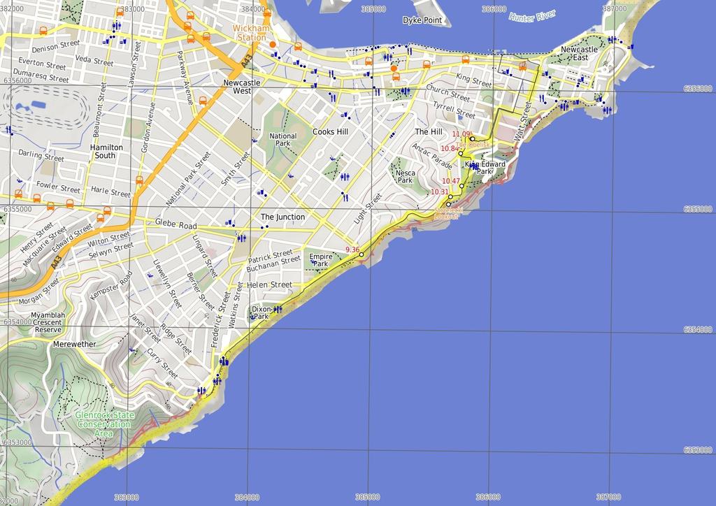
4 (2 km 40 mins) Veer left: From the GNW arrow marker, this walk follows the wide beach north, keeping the ocean on your right. This walk follows the beach past attractive cliffs and historical remnants of the coal mine (on the left), then several side tracks, over about 800m to come to an intersection with a timber formed track and information signs(on the left). The walk continues straight along the beach for another 230m until coming to another intersection with a track, beside the sheltered information sign (up the hill to the left). Continue straight: From the intersection (below the information shelter), this walk follows the beach north, while keeping the ocean on your right. The walk soon heads over a series of attractive rock platforms at the base of a large cliff and headland, and after about 1km, comes to the Merewether Ocean Baths. If there is a light to moderate onshore breeze, then you might also enjoy the view of some hanggliders and paragliders flying above. Take care along the rock platforms, especially during high tides and high seas - during particularly high tides this section may become unsafe to pass Merewether Baths (370 m 6 mins) Continue straight: From the 'Merewether Ocean Baths', this walk follows the slightly elevated footpath gently uphill, keeping the ocean and beach to your right. The walk continues to follow the footpath for about 300m, passing a large picnic shelter and some bench seats until coming to Swell cafe, under the Merewether Surf Life Saving Club building, just near the intersection of John and Henderson Parades Swell Cafe (1.4 km 26 mins) Continue straight: From the Swell cafã, this walk heads up to 'John Pde' and turns right. The walk follows the footpath alongside 'John Parade' (keeping the beach to your right) for 300m to continue straght into 'Dixon Park'. Contune up past the 'Bathers Way' sign along the footpath for another 200m (to pass alongside the carpark) and come to the picnic shelter outside the 'Dixon Park SLSC'. Continue straight: From 'Dixon Park SLSC', this walk follows the footpath moderately steeply uphill, keeping the ocean on your right for just over 100m to find Ocean St. Here the walk turns right and continues beyond the end of Ocean St heading downhill for 160m past the end of 'Kilgour Ave' to a small car park. The walk veers left across the car park and follows the footpath, past the playing fields (on the left) and alongside the beach for 350m to the 'Cooks Hill SLSC' building (on the right). The walk continues straight, beside the road and car park before climbing up some concrete stairs, to find the large Bar Beach car park (opposite the end of Parkway Ave). There are wide ocean views at the end of the car park, on your right Bar Beach car park (950 m 20 mins) Continue straight: From the large Bar Beach car park (opposite the end of Parkway Ave), this walk heads moderately steeply uphill across the car park then up the footpath beside Memorial Dr, keeping the ocean on your right. 200m past the car park, this walk comes to an intersection with a set of stairs (on your right) at a gap in the fence (these stairs lead up to an old trig point and stunning coastal views). Here, the walk continues up along the footpath beside Memorial Dr for almost 500m (past a picnic shelter and bubbler) to an intersection with High St. 'Strzelecki Lookout' is a short distance to your right, on the other side of the car park Strzelecki Lookout Strzelecki Lookout, atop the hill, is named in honor of the Polish geologist and explorer whose chemical analyses and research into coal deposits from influenced the development of the region. Wonderful views of the coastline south are available here and if you are lucky, you will see a hanglider taking off. More info Strzelecki Lookout (160 m 3 mins) Continue straight: From the intersection (near Strzelecki Lookout), this walk follows the GNW arrow post across High St then gently uphill alongside 'Cliff St'. After passing a few houses, the road bends, becoming 'The Terrace' (with views to the right). The walk follows 'The Terrace' for about 60m, past 'Shepherds Hill' (and the Marine Rescue Building) gently downhill to the signposted southern entrance of 'King Edward Park' King Edward Park (southern entrance) (370 m 7 mins) Veer right: From the southern entrance of 'King Edward Park', this walk enters the park following the driveway (York Dr) through the usually open gate. The driveway leads downhill, alongside a car park for about 80m, to veer left onto a footpath marked with a GNW arrow post. This walk follows this footpath moderately steeply downhill for about 150m, among the large pine trees, down some concrete stairs, past the toilet block to find the barbeque area beside York Dr and the 'King Edward Park Fountain'. Turn left: From the barbeque area, this walk follows the GNW arrow post up along the footpath heading between the BBQ and fountain, away from York Dr. The footpath leads up among the large pine trees for 80m, to Reserve Rd. Here the walk follows the GNW arrow post across the road at the safety island to the footpath on the other side, beside the intersection of 'Reserve Rd' and 'The Terrace' Int of Reserve Road AND The Terrace (240 m 4 mins) Turn right: From the intersection, this walk follows the GNW arrow post along the footpath beside 'Reserve Rd' keeping the white timber fence on your left. After 30m this walk turns left into 'Wolfe St' then after about 110m, this walk crosses 'Wolfe St', just before 'Ordnance St' to come to a set of concrete steps marked with a GNW arrow post. Continue straight: From the intersection, this walk follows the GNW arrow post up the concrete stairs with metal hand railing. At the top of the stairs this walk follows the sealed footpath for about 25m to the tall white stone Obelisk and monument The Obelisk This white stone monument sits above the city of Newcastle, on a green grassy knoll. The Obelisk Park is popular and gives views across the Lower Hunter Plains. The Obelisk was first erected in 1850, to replace the windmill that had stood there before it. The Obelisk was erected to act as a navigational aid for ships. On the grassy knoll is a water fountain and a large sundial The Obelisk (1 km 18 mins) Turn right: From the Obelisk, this walk heads across the grass to follows the GNW arrow post east down the gravel footpath towards the clear ocean views. This walk soon leads down the series of concrete stairs for about 120m, to find the intersection of 'Ordnance' and 'Newcomen' streets. Veer left: From the intersection, this walk follows the Great North Walk marker down Newcomen Street. The walk takes the first right down Church Street, passing the Grand Hotel and Police Station, then turning left onto Watt Street. The walk continues down Watt St until reaching the intersection with Scott St, where the walk reaches Newcastle railway station.
5
6
7 Summary navigation sheet for the Charlestown Park trackhead to Newcastle station km From 0.00 Charlestown Park , (GR Wallsend, ) End of Milson Street , (GR Wallsend, ) Int of Flaggy Creek track & Guna Street , (GR Wallsend, ) Yuelarbah carpark , (GR Wallsend, ) Int of Yuelarbah track & Glenrock scoutcamp track , (GR Wallsend, ) Int of Yuelarbah track & Glenrock scoutcamp track , (GR Wallsend, ) Int of Yuelarbah AND powerline tracks , (GR Wallsend, ) Leichhardts Lookout , (GR Wallsend, ) Glenrock Beach (north of lagoon) , (GR Wallsend, ) Merewether Baths , (GR Newcastle, ) Swell Cafe , (GR Newcastle, ) Bar Beach car park , (GR Newcastle, ) Strzelecki Lookout , (GR Newcastle, ) King Edward Park (southern entrance) , (GR Newcastle, ) Int of Reserve Road AND The Terrace , (GR Newcastle, ) The Obelisk , (GR Newcastle, ) Powered by TCPDF ( Up/Dwn Length Initial directions (Use full tracknotes and maps for more detail) m 13 mins 710 m 12 mins 1.7 km 31 mins 570 m 11 mins 1.9 km 37 mins 190 m 4 mins 300 m 6 mins 1.3 km 27 mins 2 km 40 mins 370 m 6 mins 1.4 km 26 mins 950 m 20 mins From Charlestown Park, this walk follows the 'Newcastle' sign across the Pacific Highway at the traffic lights m 3 mins 370 m 7 mins 240 m 4 mins 1 km 18 mins Continue straight: From the intersection (near Strzelecki Lookout), this walk follows the GNW arrow post across High St then gently uphill alongside 'Cliff St'. Veer right: From the southern entrance of 'King Edward Park', this walk enters the park following the driveway (York Dr) through the usually open gate. Turn right: From the intersection, this walk follows the GNW arrow post along the footpath beside 'Reserve Rd' keeping the white timber fence on your left. Turn right: From the Obelisk, this walk heads across the grass to follows the GNW arrow post east down the gravel footpath towards the clear ocean views. Veer left: From the end of Milson Street, this walk follows the GNW arrow post down over the grass and across the timber footbridge. Continue straight: From the intersection, this follows the GNW arrow post across Guna Road then follows the track east, back into the bush. Turn left: From the Yuelarbah car park, this walk follows the 'Yuelarbah walking track' sign down along the sealed footpath then along the timber boardwalk. Alternate Route Int of Yuelarbah track & Glenrock scoutcamp track. Turn right: From the intersection, this walk follows the track, while keeping the 'Yuelarbah Track' sign and creek on your left. Veer left: From the intersection, this walk follows the 'Yuelarbah Track' sign across the timber and metal suspension bridge over Flaggy Creek. Veer right: From the intersection, this walk follows the 'Yuelarbah Track' sign under the power lines and down the timber steps, while keeping the creek on your right. Continue straight: From 'Leichhardts Lookout', this walk follows the track east from the beside the lookout, whilst keeping the valley to your right. Veer left: From the GNW arrow marker, this walk follows the wide beach north, keeping the ocean on your right. Continue straight: From the 'Merewether Ocean Baths', this walk follows the slightly elevated footpath gently uphill, keeping the ocean and beach to your right. Continue straight: From the Swell cafã, this walk heads up to 'John Pde' and turns right. Continue straight: From the large Bar Beach car park (opposite the end of Parkway Ave), this walk heads moderately steeply uphill across the car park then up the footpath beside Memorial Dr, keeping the ocean on you...
Hunters Hill to Epping Road
 Hunters Hill to Epping Road 2 hrs 30 mins 5.5 km One way Moderate track 154m An enjoyable walk through lower sections of the Lane Cove National Park, this walk features plenty of mangroves next to the
Teralba to Charlestown Park track head
 Teralba to Charlestown Park track head 4 hrs 30 mins 13.3 km One way Moderate track 3 220m This section of the Great North Walk starts from the Teralba train station and winds down and around the edge
Wallarah Coastal Walk
 Wallarah Coastal Walk 3 hrs 8.3 km Return Hard track 247m This walk starts at Caves Beach and travels south along the coastline, until reaching the Pinney s Headland Lookout. There are many opportunities
The Foreshore Walk. 24m. 1m Lake Macquarie LGA. 1 hr 15 mins 2.9 km One way. Hard track 81m
 The Foreshore Walk 1 hr 15 mins 2.9 km One way Hard track 81m This walk traverses the coastline of the Green Point reserve. By following a variety of tracks and occasionally traveling inland through eucalyptus
Morgans Creek to Padstow
 Morgans Creek to Padstow 2 hrs 45 mins 8 km One way Moderate track 3 144m This pleasant walk starts from the Morgans Creek park, at Henry Lawsons Drive, and follows the Georges River past the Boomerang
Popes Glen, Pulpit Rock, Govetts Leap and Braeside Walk
 Popes Glen, Pulpit Rock, Govetts Leap and Braeside Walk 8 hrs Hard track 13.6 km Circuit 4 1068m This large circuit walk, from Popes Glen to Pulpit Rock, Govetts leap and along the Braeside Track, passes
Govetts Leap Loop. 1065m. 909m Blue Mountains National Park. 4 hrs 30 mins 8.7 km Circuit. Hard track 380m
 Govetts Leap Loop 4 hrs 30 mins 8.7 km Circuit Hard track 380m This walk, from Blackheath Train Station, is a fantastic way to see some of the iconic areas of the Blue Mountains in the Blackheath area.
Echo Point to Leura Forest via Three Sisters and Giant Stairs loop
 Echo Point to Leura Forest via Three Sisters and Giant Stairs loop 3 hrs 3.8 km Circuit Hard track 512m This walk starts from the popular Echo Point, in Katoomba, and winds down to the base of the Three
Campbell Drive to Snapper Point
 Campbell Drive to Snapper Point 1 hr 45 mins 4.2 km One way Experienced only 135m This walk follows the Coast Track to Frazer Beach, along the Geebung and (overgrown) Grass Tree Tracks. From the northern
Epping to Pennant Hills Station (via Lane Cove River)
") Epping to Pennant Hills Station (via Lane Cove River) 3 hrs 5 mins 8.4 km One way Hard track 249m This walk, from Epping to Pennant Hills Station, is a great way to see the upper Lane Cove River Valley.
Epping to Pennant Hills Station (via Lane Cove River) 3 hrs 5 mins 8.4 km One way Hard track 249m This walk, from Epping to Pennant Hills Station, is a great way to see the upper Lane Cove River Valley.
Wentworth Falls Conservation Hut Loop
 Wentworth Falls Conservation Hut Loop 3 hrs Hard track 6.7 km Circuit 4 341m This scenic walk from Wentworth Falls Station, winds along the Nature Trail to Conservation Hut, then drops into the magnificent
Sid Pulsford Walk. 175m. 33m. 1 hr 45 mins 4.1 km One way. Hard track 118m. Gosford LGA
 Sid Pulsford Walk 1 hr 5 mins.1 km One way Hard track 118m Sid Pulsford Walk explores the ridge top of Kincumber Mountain, from Honeman's Rock to Green Point. The walk mostly follows wide management trails.
Wattamolla to Big Marley Beach
 Wattamolla to Big Marley Beach 4 hrs 10.4 km Circuit Moderate track 4m This walk is an excellent loop which takes in both the coast and the heathy inland of Royal National Park. Nearly the whole walk has
Currie Rd to Davidson Park
 Currie Rd to Davidson Park 3 hrs 7.2 km One way Moderate track 28m Starting at Currie Rd in Forestville, this walk follows Middle Harbour to Davidson Park, under Roseville Bridge. There are two optional
Waterfall to Heathcote
 Waterfall to Heathcote 5 hrs Hard track 10.8 km One way 4 467m This walk explores the heart of Heathcote National Park, and is easily accessed with a train station at either end. Although relatively close
Carrington Park to Leura Forest and pass loop
 Carrington Park to Leura Forest and pass loop 3 hrs Hard track 4.8 km Circuit 4 674m This walk is a fantastic way to see Leura Forest. The walk descends from Carrington Park, visiting Leura Forest and
De Burgs Bridge to Thornleigh station
 De Burgs Bridge to Thornleigh station 3 hrs 45 mins 9.7 km One way Hard track 4 363m This walk follows a section of the Great North Walk, starting from De Burghs bridge. The walk winds north west, through
Hornsby Blue Gum Walk
 Hornsby Blue Gum Walk 3 hrs Hard track 6.7 km Circuit 4 374m This delightful loop is one of the prettiest and most popular walks in the Hornsby area. Going from an environment of ferns and clear bushland
Katoomba Falls Circuit
 Katoomba Falls Circuit hr 5 mins.5 km Circuit Hard track 59m For those looking for a walk involving more than simple boardwalk, this trail winding through the temperate rain forest could be just the thing.
Little Digger Track. 68m. 1 Hr 2.2 km One way. Moderate track 93m. Moores Creek Reserve
 Little Digger Track Hr 2.2 km One way Moderate track 93m This walk follows Moores Creek through several reserves in east Roseville and East Lindfield. The track is named after Australia's 7th Prime Minster,
Rail to River Walk. 3 hrs. Hard track 7.5 km Circuit. 222m
 Rail to River Walk 3 hrs Hard track 7.5 km Circuit 4 222m This walk is a great one from Chatswood Station to the Lane Cove River National Park. The walk descends through the vegetated bushland which fills
Green Point Circuit Walk
 Green Point Circuit Walk 3 hrs 7.7 km Circuit Hard track 269m This walk visits all of the popular locations in Green Point Reserve, as well as some of the lesser-visited areas inland. Taking in Sea Eagle
Dead Horse Gap Loop track
 Dead Horse Gap Loop track 4 hrs 30 mins Hard track 9.8 km Circuit 144m 4 This walk starts with a ride up the Kosciuszko Express Chairlift. There is an opportunity to eat at Australia's highest restaurant,
Heathcote to Engadine via Audley
 Heathcote to Engadine via Audley 6 hrs 3 mins 5 km One way Hard track 4 635m Covering a large section of central Royal National Park, this walk goes through the heath and scrub along a well managed and
Little Digger Track to Davidson Reserve and Lyrebird Circuit
 Little Digger Track to Davidson Reserve and Lyrebird Circuit 4 hrs 3 mins 11.5 km One way Hard track 4 47m Exploring both the eastern and western sides of Middle Harbour Creek, this walk follows the Little
Balmoral Beach to The Spit
 Balmoral Beach to The Spit 2 hrs 30 mins.3 km One way Hard track 85m This walks follows the coast from Balmoral to the Spit and across Spit Bridge. There are some alternate tracks to consider at high-tides,
Callicoma Loop. 174m. 98m. 2 hrs. Hard track 5.1 km Circuit. 153m
 Callicoma Loop 2 hrs Hard track 5.1 km Circuit 153m This great circuit walk passes through some really nice forest around the fringe of Cherrybrook. Highlights of the walk include some beautiful rock overhangs
Epping to Eastwood Station (via Lane Cove River)
") Epping to Eastwood Station (via Lane Cove River) hrs 45 mins 10.2 km One way Moderate track 189m Epping to Eastwood, via Lane Cove River, is the longer route through the bush between the stations. This
Epping to Eastwood Station (via Lane Cove River) hrs 45 mins 10.2 km One way Moderate track 189m Epping to Eastwood, via Lane Cove River, is the longer route through the bush between the stations. This
Rail to River and Stringybark Creek Reserve Walk
 Rail to River and Stringybark Creek Reserve Walk 4 hrs Hard track 11.2 km Circuit 4 302m This walk begins in the busy city of Chatswood and soon enters the nearby bushland around the Lane Cove River. The
The Basin Track and Mackerel Track
 The Basin Track and Mackerel Track 3 hrs 5.9 km Circuit Hard track 226m This walk is a great way to see some popular areas in Ku-ring-gai Chase National Park. The walk from West Head Rd travels to The
Bouddi Coastal Walk. 5 hrs. Hard track 8.1 km One way. 364m
 Bouddi Coastal Walk 5 hrs Hard track 8.1 km One way 4 364m This is one of the longer walks in the Bouddi National Park and it is rich in scenery. The walk follows the coastline with many side trips to
Mackerel Beach, West Head Loop
 Mackerel Beach, West Head Loop 5 hrs 8.6 km Circuit Hard track 422m The Mackerel Beach, West Head Loop is a walk which explores a large part of the West Head. The journey starts and finishes with a ferry
Scenic World to Echo Point
 Scenic World to Echo Point 1 hr 15 mins 2.1 km One way Moderate track 192m This is one of the most popular tourist walks in the Katoomba area. The walk follows the cliffs along a well maintained and signposted
Berowra to Mt Kuring-gai
 Berowra to Mt Kuring-gai 4 hrs 30 mins 9.4 km One way Hard track 4 551m From the ridges above Cowan Creek, this walk takes in some great lookouts (especially around Mt Kuringgai) as well as enjoying an
Under and Over Cliff Walk
 Under and Over Cliff Walk 4 hrs 9.4 km Circuit Moderate track 576m This walk from Wentworth Falls Station is a fantastic way to see a large majority of the Wentworth Falls cliffline. The track winds under
Woolwich Wharf to Boronia Park
 Woolwich Wharf to Boronia Park 2 hrs 5.8 km One way Moderate track 175m Going through the streets of Hunters Hill, this walk is on the first segment of the Great North Walk. The majority of the walk is
Sphinx, Warrimoo and Bobbin Head tracks
 Sphinx, Warrimoo and Bobbin Head tracks 4 hrs 9.6 km Circuit Moderate track 499m This great walk starts at the Sphinx Memorial and loops around via Cowan Creek, exploring diverse environments as it changes
Mackerel Beach and Resolute Loop
 Mackerel Beach and Resolute Loop 3 hrs 5.4 km Circuit Hard track 384m This walk is another great walk in Ku-ring-gai Chase National Park, accessed by ferry. From the Mackerel Beach wharf, this walk uses
Patonga to Woy Woy. 5 hrs 45 mins 15.5 km One way. Hard track. 497m
 Patonga to Woy Woy 5 hrs 45 mins 15.5 km One way Hard track 4 497m This walk explores a variety of environments from the shore line and coastal cliffs near Patonga, to the dry, rocky and open ridge line.
Middle Harbour Creek Loop
 Middle Harbour Creek Loop 5 hrs 45 mins 15.1 km Circuit Experienced only 5 570m This walk explores the upper reaches of Middle Harbour Creek, starting and ending at the great parklands at Davidson Park,
De Burghs Bridge to Fullers Bridge
 De Burghs Bridge to Fullers Bridge 2 hrs 3 mins Hard track 6 km One way 2m 4 Following the Lane Cove River, this walk mostly follows a section of the Great North Walk and is well maintained and signposted.
National Pass from Wentworth Falls to Conservation Hut
 National Pass from Wentworth Falls to Conservation Hut 3 hrs Hard track 3.6 km One way 739m Starting at Wentworth Falls picnic area, this scenic and historic walk explores many waterfalls, lookouts and
Upper Rumbalara circuit
 Upper Rumbalara circuit 1 hr 30 mins 3.3 km Circuit Hard track 176m A great circuit walk, covering most of the walking tracks and sights in the upper section of the Rumbalara Reserve. There is some really
Epping to Gordon Station
 Epping to Gordon Station 4 hrs 15 mins 11.7 km One way Hard track 4 365m This walk, from Epping Station to Gordon Station, passes below the homes which sit on the hills high above the Lane Cove River.
Spit Bridge to Middle Head Forts
 Spit Bridge to Middle Head Forts 2 hrs 30 mins 6.3 km One way Hard track 4 181m This scenic walk takes you from the Spit Bridge, along the coast to explore the Middle Head Forts. There are a few alternate
Wentworth Falls Station Loop (Undercliff Walk)
") Wentworth Falls Station Loop (Undercliff Walk) 4 hrs 3 mins Hard track 8.9 km Circuit 658m 4 This walk passes some stunning waterfalls and views into the Jamison Valley, following the cliff edges around
Wentworth Falls Station Loop (Undercliff Walk) 4 hrs 3 mins Hard track 8.9 km Circuit 658m 4 This walk passes some stunning waterfalls and views into the Jamison Valley, following the cliff edges around
Federal Pass Walking Track
 Federal Pass Walking Track 5 hrs Hard track 8 km One way 4 989m This classic trail follows along the base of the cliffs from Leura to the Golden Stairs, passing many of the more popular sights of the Katoomba
Taronga Wharf to Chowder Bay
 Taronga Wharf to Chowder Bay 2 hrs 4.4 km One way Moderate track 246m Starting at Taronga Wharf, this walk passes many icons of Sydney, including Taronga Zoo, HMAS Sydney Mast, Chowder Bay. The walk also
Blackheath Station to Junction Rock Loop (via Grand Canyon and Popes
 Blackheath Station to Junction Rock Loop (via Grand Canyon and Popes 8 hrs 30 mins 18.2 km Circuit Hard track 4 1254m This circuit starts in Blackheath and heads down into the Grand Canyon and Rodriguez
Roseville to Macquarie Park
 Roseville to Macquarie Park 3 hrs 3 mins 8.8 km One way Hard track 4 29m This walk starts at Roseville station and explores the streets and alleyways of Roseville before joining the main spine of the Great
Dubbo Gully and Ten Mile Hollow Circuit (via Clares Bridge)
") Dubbo Gully and Ten Mile Hollow Circuit (via Clares Bridge) 2 Days Hard track 24.3 km Circuit 4 1117m This two day (or ten hour) walk follows several historic roads, now closed to traffic. Starting with
Dubbo Gully and Ten Mile Hollow Circuit (via Clares Bridge) 2 Days Hard track 24.3 km Circuit 4 1117m This two day (or ten hour) walk follows several historic roads, now closed to traffic. Starting with
Echo Point to Leura Forest Circuit
 Echo Point to Leura Forest Circuit 3 hrs 4.8 km Circuit Hard track 588m Forming a circuit around the cliffs and then the valley floor, this is a walk more then capable of convincing a walker of the beauty
Hermitage Foreshore Track
 Hermitage Foreshore Track 1 Hr 2.2 km One way Moderate track 123m The Hermitage Foreshore Walk is a wonderful way to explore Sydney Harbour from the perspective of South Head. This walk starts from Nielsen
Glenbrook and Euroka Circuit
 Glenbrook and Euroka Circuit 2 Days 16.6 km Circuit Experienced only 790m This two day circuit, returning to Glenbrook Station, is a scenic walk which passes many of the tourist attractions within the
Thornleigh to Hornsby
 Thornleigh to Hornsby 4 hrs Hard track 10.2 km One way 4 526m Starting at Thornleigh station you walk through suburban streets for a short while before diving into the bush at the southern end of Berowra
Wentworth Falls Loop. 893m. 665m. 6 hrs 10.2 km Circuit. Hard track 1093m. Blue Mountains National Park
 Wentworth Falls Loop 6 hrs 1.2 km Circuit Hard track 193m This is a great walk, both in size and spectacular views. The walk makes its way from Wentworth Falls train station and drops off the plateau,
Gordon to Chatswood Station
 Gordon to Chatswood Station 4 hrs 30 mins 12.2 km One way Hard track 4 381m This walk is a great way to get into the bush without being far from civilisation. The walk wanders through untouched valleys
North Ryde Fairyland circuit
 North Ryde Fairyland circuit 2 hrs 30 mins Hard track 6.9 km Circuit 193m 4 Starting at North Ryde train station this walk explores a stretch of the Lane Cove River, visiting the historic Fairlylands Pleasure
Wentworth Falls Station Loop
 Wentworth Falls Station Loop 5 hrs 3 mins 9.5 km Circuit Hard track 4 13m The Wentworth Falls Station Loop takes in most of the upper tracks around Wentworth Falls. There are many scenic views near the
Lane Cove Tourist Park River Circuit
 Lane Cove Tourist Park River Circuit 5 hrs 12 km Circuit Hard track 383m This walk follows a large section of Lane Cove River. The walk follows the Riverside Walking track up the Lane Cove River to De
Sphinx to Mt Kuring-gai
 Sphinx to Mt Kuring-gai 4 hrs 45 mins 1.7 km One way Hard track 673m This walk starts at the Sphinx War Memorial and follows some well maintained and popular walking tracks down to Cowan Creek. Enjoy the
Rumbalara Explorer. 158m. 5m Rumbalara Reserve. 2 hrs 45 mins 6.1 km Circuit. Hard track 326m
 Rumbalara Explorer 2 hrs 5 mins 6.1 km Circuit Hard track 326m Pretty well the grand tour of the Rumbalara Reserve, this walk takes in much of the great scenery the reserve has to offer. The walk covers
Gosford to Lisarow. 202m
 Gosford to Lisarow 4 hrs 3 mins Hard track 11.3 km One way 4 479m This walk is a great way to explore the ridge-top bushland between Gosford and Lisarow. Passing through Rumbalara and Katandra Reserves,
Narrabeen Lagoon Trail (from Middle Creek)
") Narrabeen Lagoon Trail (from Middle Creek) 2 hrs 30 mins 8.6 km Circuit Very easy 1 105m The Narrabeen Lagoon Trail is a wonderful and accessible walk on the Northern Beaches of Sydney. The trail is used
Narrabeen Lagoon Trail (from Middle Creek) 2 hrs 30 mins 8.6 km Circuit Very easy 1 105m The Narrabeen Lagoon Trail is a wonderful and accessible walk on the Northern Beaches of Sydney. The trail is used
The Coast Track. 2 Days. Hard track 27.4 km One way. 1351m
 The Coast Track 2 Days Hard track 27.4 km One way 4 1351m Heading south, this walk covers the coastline of the Royal National Park and can truly only be described as amazing. With breathtaking coastal
Spit Bridge to Manly (Manly Scenic Walkway)
") Spit Bridge to Manly (Manly Scenic Walkway) 3 hrs 45 mins 9.1 km One way Moderate track 349m The Spit to Manly walk is a classic bushwalk on Sydney's Northern Beaches. The walk follows a well-maintained
Spit Bridge to Manly (Manly Scenic Walkway) 3 hrs 45 mins 9.1 km One way Moderate track 349m The Spit to Manly walk is a classic bushwalk on Sydney's Northern Beaches. The walk follows a well-maintained
Cape Banks Circuit. 50m. 2m Botany Bay National Park. 3 hrs 7.3 km Circuit. Hard track 190m
 Cape Banks Circuit 3 hrs 7.3 km Circuit Hard track 19m This Cape Banks Circuit has a lot to offer and is thoroughly recommended. The walking travels over beaches, through coastal forest and across exposed
Scenic world to Three Sisters Loop via Furber Steps
 Scenic world to Three Sisters Loop via Furber Steps 5 hrs 5.8 km Circuit Hard track 722m This walk starts from the popular Scenic World, in Katoomba, and winds down the Furber steps into the Jamison Valley,
Faulconbridge to Blaxland
 Faulconbridge to Blaxland 2 Days Experienced only 15.2 km One way 5 693m This two-day walk, or very solid one-day walk, takes you from station to station, through lush, scenic forest in the lower Blue
Bobbin Head Loop. 166m. 0m Ku-ring-gai Chase National Park. 5 hrs 12.9 km Circuit. Hard track 619m
 Bobbin Head Loop 5 hrs 12.9 km Circuit Hard track 619m This great circuit walk enjoys a variety of landscapes in Ku-ring-gai Chase National Park. The walk starts at the historic Sphinx war memorial and
Bouddi Ridge and Coastal Walk
 Bouddi Ridge and Coastal Walk 2 Days Hard track 27 km Circuit 4 126m This overnight walk takes in the majority of the magnificent Bouddi National Park. The walk starts from the pleasant Putty Beach camping
Manly to Seaforth Oval
 Manly to Seaforth Oval 5 hrs 45 mins 13.7 km One way Moderate track 3 624m This walk follows the Manly to Spit Scenic Walkway, then continues past The Spit Bridge to Seaforth Oval. The walk provides magnificent
Chatswood to Epping Station
 Chatswood to Epping Station 6 hrs Hard track 16.3 km One way 4 533m This walk, from Chatswood to Epping, is a long but enjoyable walk along the Lane Cove valley. The walk mostly follows the Lane Cove River
Taronga Zoo to Spit Bridge
 Taronga Zoo to Spit Bridge 5 hrs Hard track 1.4 km One way 4 41m This is a scenic and culturally rich walk with views over Sydney Harbour and many interesting heritage buildings along the way. The start
Six Foot Track. 1212m
 Six Foot Track 3 Days 44.8 km One way Hard track 4 2066m This classic walk takes you from Katoomba to Jenolan Caves via a historic horse route. The walk travels mainly along well-maintained service tracks
Sydney to Thornleigh via Lane Cove Tourist Park
 Sydney to Thornleigh via Lane Cove Tourist Park 2 Days 33 km One way Hard track 4 1114m This overnight walk starts from the Obelisk in Macquarie Park, Sydney, at the official start of the Great North Walk.
Light to Light Walk 2 days
 Light to Light Walk 2 days 2 Days Hard track 3.9 km One way 4 794m Over two days, this classic walk explores the coast from Boyd Tower to the Green Cape Lighthouse in the south. Hegartys Bay Camp is over
Beautiful Walks from the Blue Ball Inn
 Walk No. 7 COAST AND VALLEY WALK Countisbury, Glenthorne, County Gate, Brendon, Rockford and Wilsham 10 MILES APPROX. Walking time 5 hours approx. (not including breaks)> OS Sheet 64/74 Lynton and Lynmouth.
NEWLANDS CORNER AND ST MARTHAS
 NEWLANDS CORNER AND ST MARTHAS 10k CIRCULAR ROUTE 2½-3HRS GU4 8SE From Newlands Corner on the North Downs just outside Guildford, you can enjoy one of the most beautiful panoramas of quintessential English
RILLINGTON TO MALTON by Tania Dickinson
 RILLINGTON TO MALTON by Tania Dickinson This walk takes you from the Vale of Pickering up on to the Wold scarp, before dropping down again through the pretty village of Settrington and joining the Centenary
ST. AGNES. you cannot put a time limit on beauty.
 ST. AGNES CIRCULAR WALKS AROUND There are many enjoyable and picturesque walks around St. Agnes most are signposted and are featured on the St. Agnes Mini-guide map. Because most of our footpaths are in
LDWA SOUTH DOWNS MARATHON 13 th MAY 2018
 AHD ahead SDW South Downs Way BL/BR bear left/bear right TL/TR turn left/turn right X cross LEG 1 - EAST DEAN to WP1 NORTON GR 470019. Open 1030 to 1300. 9.7 miles. 1.1 From village hall TL and walk to
MELBOURNE MIDDAY MILERS MARCH MADNESS BARWON HEADS 5MS RELAY
 MELBOURNE MIDDAY MILERS MARCH MADNESS BARWON HEADS 5MS RELAY 2013 Pre-race admin 1. We will meet at 8.15am on Sunday 17 March in the car park opposite the Barwon Heads Hotel & fronting the beach on Ewing
ULTRA-TRAIL AUSTRALIA May 2018 COURSE DESCRIPTION AND COURSE NOTES
 ULTRA-TRAIL AUSTRALIA 100 19-20 May 2018 COURSE DESCRIPTION AND COURSE NOTES LEG 1 Scenic World (Start) to Narrow Neck (Checkpoint 1) Course Description: From the start, at the front entrance of Scenic
SELF GUIDED TOURING ROUTE
 SELF GUIDED TOURING ROUTE Things to see and places to go on the loop from Orbost to Marlo, Cape Conran, Cabbage Tree and back to Orbost (or onwards to Cann River) V6 April 2017 This guide should be read
THE WELLDIGGERS ARMS, HESWORTH AND FITTLEWORTH TRAIL
 THE WELLDIGGERS ARMS, HESWORTH AND FITTLEWORTH TRAIL 5.5 miles Circular 3 hours 041017 Challenging Terrain A 300-year-old pub turned country-inn on the edge of the South Downs National Park, The Welldiggers
Times. S E S/Rd(E) Wakefield Road) Wakefield Rural Fire Brigade
 Wakefield Road) Wakefield Rural Fire Brigade") START On York Street, Teralba adjacent to Tulkaba Park Sports Pavilion (on leaving travel west on York Street) [EEP-1A] Position* Altitude Distance (km)* Trail S32 57.593 E151 36.520 21 0.5 0.5 S/Rd(E)
START On York Street, Teralba adjacent to Tulkaba Park Sports Pavilion (on leaving travel west on York Street) [EEP-1A] Position* Altitude Distance (km)* Trail S32 57.593 E151 36.520 21 0.5 0.5 S/Rd(E)
Tideswell to Castleton
 Tideswell to Castleton 1 Walk summary Length: 14 km, 8.5 miles Maps: OS Explorer OL1 The Peak District - Dark Peak Area, OS Explorer OL24 The Peak District - White Peak Area, OS Landranger 110 Sheffield
Hammer Vale and Linchmere Common
 point your feet on a new path Hammer Vale and Linchmere Common Distance: 9 km=5½ miles or 6 km=3¾ miles easy walking with one steep section Region: Hampshire, West Sussex Author: Botafuego Refreshments:
Welsh Newton and Woodland
 Welsh Newton and Woodland This is a 8.2km miles (approx) walk which will take about 2.5 hours at a relaxed and leisurely pace. There are a few hills but no steep inclines. Start at Llangrove bus stop and
Winterfold Wood. point your feet on a new path. In Brief
 point your feet on a new path Winterfold Wood Distance: 8½ km=5¼ miles Region: Surrey Author: Schwebefuss Refreshments: Windmill Inn, Peaslake after the walk moderate walking with many gradients Date written:
Rhossili - Tears Point - Mewslade Bay - Talgarth's Well - Rhossili - ID: 148. Walk description:
 Walk description: A glorious walk combining thrilling cliffs with beautiful wild beaches and a bird's-eye view of the Gower peninsula from Rhossili Down. The adventurous can walk out to the Worm's Head
Walk 7: Watchet to washford
 Walk 7: Watchet to washford Length: Moderate - 7.5 miles / 12 km Good For: Theme: History Duration: 2-3 hours depending on speed of walking Notes: This is a moderate to difficult walk in places, with steps,
Harbour Bridge to Taronga Zoo
 Harbour Bridge to Taronga Zoo 4 hrs 9.8 km One way Moderate track 389m On this walk, you will explore much of the foreshore linking Milsons Point Station to Taronga Zoo Ferry wharf. The walk is mostly
The Year Of Mercy Pilgrimage Sts Peter and Paul s Church, Bulimba To The Cathedral of St Stephen
 The Year Of Mercy Pilgrimage Sts Peter and Paul s Church, Bulimba To The Cathedral of St Stephen Dist Route Photos Photos 0.0km St Peter and Paul s Church, 235 Riding Rd & Cnr Main Ave, Balmoral. http://www.bulimbacatholic.com/
LDWA SOUTH DOWNS MARATHON
 AHD ahead SDW South Downs Way BL/BR bear left/bear right TL/TR turn left/turn right SP signpost/fingerpost X cross LEG 1 - EAST DEAN to WP1 NORTON GR 470019. Open 1030 to 1300. 9.6 miles. 1.1 From village
Approximate distance: 10 miles For this walk we ve included OS grid references should you wish to use them. Start. End
 Approximate distance: 10 miles For this walk we ve included OS grid references should you wish to use them. 2 3 Start End 1 N W E S Reproduced by permission of Ordnance Survey on behalf of HMSO. Crown
THE BECK STONE Backstone Beck on Ilkley Moor
 THE BECK STONE Backstone Beck on Ilkley Moor 1 Three different routes which take in the best of the lower slopes of Ilkley Moor, with bracken, heather, a tarn (a small mountain lake) and rushing streams.
Chapel Point to Anderby Creek
 Coastal Country Park Walks Chapel Point to Anderby Creek A CIRCULAR WALK OF 8.5 OR 6 KM (5.3 OR 3.75 MILES) INTRODUCTION The Lincolnshire Coastal Country Park lies between Sandilands, Chapel St Leonards
10 Miles Circular 5 hours
 VISIT RYEDALE PICKERING AND CAWTHORN CAMPS 10 Miles Circular 5 hours Moderate Terrain 120616 A 10 mile (16km) there and back walk from the market town of Pickering in Ryedale. The route heads north through