Taronga Zoo to Spit Bridge
|
|
|
- Nigel Marsh
- 5 years ago
- Views:
Transcription


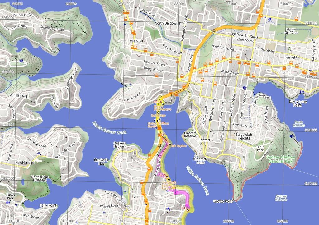
1 Taronga Zoo to Spit Bridge 5 hrs Hard track 1.4 km One way 4 41m This is a scenic and culturally rich walk with views over Sydney Harbour and many interesting heritage buildings along the way. The start at the zoo allows for a possible visit. The walk then passes the Bacino Bar on the way through the military heritage buildings. This is an excellent walk to do on a hot summer's day, with access to beautiful beaches along the whole walk. 79m m Sydney Harbour National Park Maps, text & images are copyright wildwalks.com Thanks to OSM, NASA and others for data used to generate some map layers.
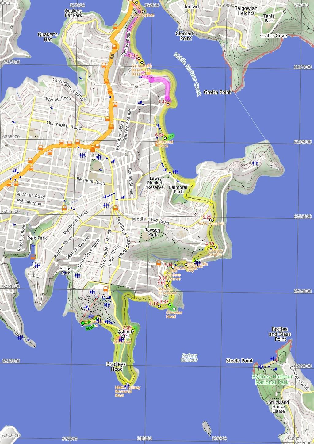
2 Taronga Zoo Before You walk Taronga Zoo was founded in 1916, with the vision of imitating the Hamburg Zoo's bar-less exhibits. Since its opening, Taronga Zoo has directed more attention to research, education and conservation efforts to support the animals. Taronga Zoo is open everyday 9am5pm. Phone: or groups@zoo.nsw.gov.au. More info. Bushwalking is fun and a wonderful way to enjoy our natural places. Sometimes things go bad, with a bit of planning you can increase your chance of having an ejoyable and safer walk. Before setting off on your walk check Athol Hall Athol Hall, built in 198, was once a hotel. Sections of the original building date back to the 18's. The hall has an excellent vantage point over the harbour with the Sydney Opera House, Harbour Bridge and city all well within its scope. Athol Hall today is a cafe and function centre with the cafe open Tues-Fri and Sun, 11am -3pm. More info. HMAS Sydney Memorial Mast The HMAS Sydney Memorial Mast was erected in 1934, following the HMAS Sydney's decommissioning in The mast stands as a sign of respect for 'Australian officers, sailors and ships lost at sea and in combat'. HMAS Sydney itself was a Chatham Class light cruiser which saw action in WW1. More info. Chowder Head Chowder Head provides a small unfenced rocky outcrop to enjoy the wide harbour views. From this vantage point, there are views across the water to South Head, Vaucluse, Rose Bay, Shark Island and Bradleys Head. A great spot to watch the sailing boats on a clear day. Morella St lookout This informally named clearing behind some houses on Morella St provides a great view across the harbour. The fairly large clearing has been maintained and is a good place to stop if wanting to avoid the large groups at Clifton Gardens. 1) Weather Forecast (BOM Metropolitan District) 2) Fire Dangers (Greater Sydney Region, unknown) 3) Park Alerts (Sydney Harbour National Park) 4) Research the walk to check your party has the skills, fitness and equipment required 5) Agree to stay as a group and not leave anyone to walk solo Think before you TREK The 'Think before you TREK' program developed by NSW Police & NPWS promotes the benefits of planning ahead for your bushwalking trip by using an easy to remember acronym: adequate supplies of food, water, navigation and first T Take aid equipment. your planned route and tell friends and family when R Register you expect to return. beacon (PLB's) should be carried on walks with E Emergency significant gaps in mobile coverage (check terrain profile). to your planned route and follow the map and walking K Keep trails. Topo Maps The maps provided on wildwalks are helpful, but there are times where you may need maps covering a broader area. Maps that cover this walk include; 1:25 Map Series:9133N PARRAMATTA RIVER, 9132N SYDNEY HEADS 1:1 Map Series:913 SYDNEY Grade This walk has been graded using the AS The overall grade of the walk is dertermined by the highest classification along the whole track. 4 Grade 4/6 Hard track Length 1.4 km One way Time 5 hrs Quality of track Rough track, where fallen trees and other obstacles are likely (4/6) Signs Minimal directional signs (4/6) Experience Required Moderate level of bushwalking experience recommended (4/6) Weather Storms may impact on navigation and safety (3/6) Infrastructure Limited facilities, not all cliffs are fenced (3/6)
3 Are you ready to have fun? Please ensure you and your group are well prepared and equipped for all possible hazards and delays. Check park closures, weather information and Fire Danger Rating before setting out. Optional side trips and alternate routes noted are not included in this walks overall grade, length or time estimate. Please allow extra time for resting and exploring areas of interest. The authors, staff and owners of wildwalks take care in preparing this information but will not accept responsibility for any inconvenience, loss or injury you may experience. Please take care, have fun - Happy Walking. Getting there You can get to Taronga Zoo Wharf (gps: , ) by car, ferry or bus. Car: There is free parking available. You can get back from Int. Battle Boulevard and Manly Rd (gps: , ) by car or bus. Car: There is free parking available. Find up to date and more information inlcuding; travel directions, weather, park closures and walker feedback at Taronga Zoo Wharf (22 m 4 mins) From the wharf, the walk heads uphill along the footpath beside the road to the Taronga Zoo entrance at the pedestrian crossing..22 Taronga Zoo Taronga Zoo was founded in 1916, with the vision of imitating the Hamburg Zoo's bar-less exhibits. Since its opening, Taronga Zoo has directed more attention to research, education and conservation efforts to support the animals. Taronga Zoo is open everyday 9am- 5pm. Phone: or groups@zoo.nsw.gov.au. More info..22 Taronga Zoo Entrance (41 m 9 mins) Turn right: From the opposite the zoo entrance, the walk heads down the ramp leaving the road up to the left. The track soon leads to a a lookout with a set of bench seats and good harbour views. The walk continues along the footpath to a wire fence then follows the 'Walking Track' sign along the hillside to climb a few steps and cross a wooden bridge. The track comes to the corner of Athol Hall's grass clearing. Veer right: From the intersection, the walk heads down the stairs then continues along the hill for a short time. The walk descends more stairs to a signposted intersection..63 Athol Hall Athol Hall, built in 198, was once a hotel. Sections of the original building date back to the 18's. The hall has an excellent vantage point over the harbour with the Sydney Opera House, Harbour Bridge and city all well within its scope. Athol Hall today is a cafe and function centre with the cafe open Tues-Fri and Sun, 11am -3pm. More info..63 Alternate Route Int. Borogegal Walking Trail and A (28 m 6 mins) Turn left : From the intersection, this walk follows the sign to 'Athol Hall' up the stairs, crossing a large grassy area. The walk then continues up to Athol Hall entrance. Turn left: From the entrance to Athol Hall, this walk heads up the hill, with the views of Sydney Harbour on the left. The walk continues up the road, where it crosses to the parking toll booth. Continue straight: From the corner of Bradley Head Rd and the car park, this walk heads down the hill just behind the parking pay booth. The track meanders down the hill to a signposted intersection. Now Turn left to rejoin the main walk..63 Int. Borogegal Walking Trail and Athol Hall Trk (67 m 16 mins) Continue straight: From the stairs, this walk heads around the hillside with the harbour below on the right. The walk travels across large sections of boardwalk which undulate slightly as the walk comes up to a trail (which leads to a bench overlooking Sydney Harbour). From the trail, this walk keeps contouring along the hillside, south and tending left, to the intersection, signposted as the way to 'Cannons picnic area'. Continue straight: From the intersection, this walk heads towards the car park, keeping the harbour to the right. The walk leads approximately 1m to the intersection with a track (leading down to Bradleys Head Amphitheatre). Veer left: From the intersection, this walk heads along the footpath next to the car park for a short distance, until it comes to be above the flag pole, HMAS Sydney Mast. 1.3 HMAS Sydney Memorial Mast The HMAS Sydney Memorial Mast was erected in 1934, following the HMAS Sydney's decommissioning in The mast stands as a sign of respect for 'Australian officers, sailors and ships lost at sea and in combat'. HMAS Sydney itself was a Chatham Class light cruiser which saw action in WW1. More info. 1.3 HMAS Sydney Mast, Bradleys Head (79 m 17 mins) Continue straight: From the intersection, this walk heads along the footpath, keeping the road to the left, for about 15m to where the road bends sharply left. From this point, this walk heads along boardwalk, on your right, keeping the water glimpses to your right. The board walk soon end and this walk follows the track along the side of the hill for about 6m to come to an intersection with a sign pointing back to 'Bradleys Head'. 2.9 Optional sidetrip to Taylors Bay Lookout (5 m 1 mins) Turn right: From the intersection, the walk heads away from the main tracks winding into the bush. The track winds past two white benches, to a small rock shelf overlooking the water. At the end of this side trip, retrace your steps back to the main walk then Turn right. 2.9 Int. Borogegal Walking Trail and Taylors Bay Looko (1.1 km 27 mins) Continue straight: From the intersection, this walk heads into Taylors Gully, with Taylors Bay below on the right. The track continues for approximately 3m, contouring around the hill with views of Taylors Bay on the right. Tending right, this walk enters and exits Taylors Gully, to continue approximately 25m to the signposted intersection at the beginning of the houses, on the left. Continue straight: From the intersection, the walk heads along the line of the houses, on the left, for approximately 14m. The track passes a Japanese Submarine information sign on the right as it continues along sections of boardwalk track, to the intersection next to the last house. The walk heads up the stairs below the last house to be met by a large sandstone staircase on the left and a track to the front Bottom of the Iluka and Morella access track (15 m 4 mins) Continue straight: From the intersection, this walk heads away from the house and clearing along the fairly flat track keeping the water glimpses to your right. The path soon leads to a clear three-way intersection with a 'Ashton Park' sign pointing back along the track. Chowder Head provides a small unfenced rocky outcrop to enjoy the wide harbour views. From this vantage point, there are views across the water to South Head, Vaucluse, Rose Bay, Shark Island and Bradleys Head. A great spot to watch the sailing boats on a clear day Chowder Head track intersection (28 m 6 mins) Turn left: From the intersection, this walk follows 'Clifton Gardens' sign gently up the hill. The track leads through the bush for a short time to soon come to another three-way intersection, this one marked with a 'Morella Rd' sign (on your left). Veer left: From the intersection, this walk follows the main track keeping the water glimpses to your right (and the Morella Rd track to your left). The track gently works is way around the hill to come to a sign point back to 'Ashton Park' and a large clearing with good views behind some houses Morella St lookout This informally named clearing behind some houses on Morella St provides a great view across the harbour. The fairly large clearing has been maintained and is a good place to stop if wanting to avoid the large groups at Clifton Gardens Morella St lookout (8 m 3 mins) Turn right: From the intersection, this walk follows 'Clifton Gardens' sign downhill along the concrete path, behind the line of houses. The path leads down the hill, following a series of steps past a bench seat to come to a 'T' intersection (with Sarah's Walk, part way down a set of steps) Bottom of Sarahs walk steps (25 m 5 mins) Turn right: From the intersection, this walk heads down the steps that soon flatten out as the footpath leads around the headland under a few sandstone overhangs. The walk soon comes to a 'Foreshore Path' sign pointing back along the path at the south-western end of Clifton Gardens. Turn right: From the intersection, this walk heads down onto the beach, towards the wharf in the middle of the beach. The walk passes an Illawarra Flame tree, as it heads approximately 1m along the beach to the start of the wharf Clifton Gardens Reserve Clifton Gardens was developed as a picnic spot in the late 18s, with a local hotelier building a wharf and dance pavilion. In 199, Sydney Ferries Ltd purchased the estate, and further developed the area, including a large swimming enclosure. The structure burned down in Today, Clifton Gardens is touted as 'remnant bushland', offering birdwatching, a netted swimming enclosure, change rooms, a fenced playground, and of course, spectacular views over Chowder Bay. A short bush track leads through to Rawson Oval Clifton Gardens Baths (21 m 5 mins) Continue straight: From the wharf, this walk heads towards the playground-end of the beach. The walk leads along the beach, passing the playground and rocky outcrop on the left to tend right onto a boardwalk. The boardwalk takes the walk to the lower gate of Chowder Bay Optional sidetrip to Chowder Head (9 m 2 mins) Turn right: From the intersection, this walk follows the 'Chowder Head' sign south-west along the clear track. The track heads gently downhill and bends left past some dead gums to find an unfenced rock platform with great harbour views. (Note the informal track continues down becoming steeper, leading to a small bay.) At the end of this side trip, retrace your steps back to the main walk then Veer right Bacino Kiosk The Bacino Kiosk, just next to Clifton Gardens, is a smaller version of the Bacino Bar above at Chowder Bay. This kiosk supplies passers-by with a home-blend coffee and sandwiches, and all at a reasonable price ($5-12). The Kiosk is open from 7am-4pm every day, except Christmas and bad weather. More info Chowder Head 4.14 Chowder Bay Lower Gate
4 (23 m 4 mins) Continue straight: From the gate, this walk heads towards the wharf approximately 8m away. The walk soon passes Bacino Kiosk on the left, and continues along the foreshore footpath to the start of the wharf. Turn left: From the wharf, this walk heads directly away from that wharf, heading up the stairs. At the top of the stairs, this walk follows the footpath right, around a flag pole and house on the left. The walk continues past a round-about, to the start of a car park, opposite Bacino Bar Chowder Bay Chowder Bay looks over Sydney Harbour, to Vaucluse and Rose Bay. The bay is named after the food of the American whalers stationed at Clifton Gardens, 'clam chowder'. Chowder Bay then became a Submarine Mining Depot in Today, Chowder Bay still has great views from the remaining military buildings on the hillside. One of the newer buildings houses a cafe, and other buildings stand as monuments to their former use. Chowder Bay offers great views with easy access to Clifton Gardens for a swim Roundabout at end of Chowder Bay Road (2 m 1 mins) Turn left: From the road, this walk heads north away from the harbour to the base of the stone steps on the left hand side of Bacino Bar Optional sidetrip to Bacino Bar (3 m 1 mins) Turn right: From the intersection, this walk heads onto the decking of Bacino Bar. At the end of this side trip, retrace your steps back to the main walk then Turn right Bacino Cafe The Bacino Bar is in Building No.2 at Chowder Bay, with great views across Sydney Harbour. The bar sells pastas, panini, arancini, tramezzini, stuffed eggplant and biscotti, along with homemade sandwiches and treats. The Bacino Bar prices are reasonable, ranging between $5-12 for the delicacies, and their coffee is made of their own blend. The bar is open every day from 7am- 4pm except for Christmas. A public toilet is available at the Eastern end of the building. More info Int. Bacino Bar back deck and Chowder Bay Trk (4 m 9 mins) Continue straight: From the intersection behind Bacino Bar, the walk heads up the steep stone steps, away from the cafe. The track then tends right, across the hill for a short time climbing the uneven stairs to meet the road and signposted intersection. Turn right: From the intersection, this walk heads across the road to head up the bush track on the hill for approximately 5m, to the signposted intersection behind 'Georges Head Lookout'. Turn right: From the intersection, this walk follows the sign to Georges Head Lookout, down the hill to the circular paved lookout above the fortifications Georges Heights Georges Heights is a gun emplacement with a commanding 18degree view over the entrance to the harbour. The old gun emplacements are still in position, with their arcs of fire explained in the signs nearby. The view from this lookout is magnificent Georges Head Lookout (45 m 8 mins) Turn around: From the circular lookout of Georges Head Lookout, this walk follows the sandstone pavement back to the road at the signposted intersection. Turn right: From the intersection, this walk follows the signs to 'Balmoral Beach' up the hill for a short while. The track opens out to a clearing on the left which has some old structures in it. This is the World War 1 hospital WW1 Hospital This military hospital was in use from 1916 to 1923, and could treat up to 42 troops at any one time. Sydney Harbour Trust completed restoration of the buildings mid-25. These buildings are New South Wales' only surviving military hospital buildings from WW Int. WW1 Hospital and Chowder Bay Trk (1.7 km 35 mins) Veer right: From the intersection, this walk heads up and across the hill, leaving the WW1 hospital behind on the left. The path continues up the hill, passing a sculpture (a bit overgrown on the right), then bending left (passing through a gate that is locked overnight at 6pm) up to Middle Head Rd. The walk crosses the road to the signposted intersection on the other side. Continue straight: From the intersection, this walk follows the sign to 'Balmoral Beach' downhill away from the road. The walk heads down many flights of stairs and turns right, through a fence. The track then turns left to continue down more stairs, which lead the walk across a bridge and next to an oval with a signposted intersection. Turn right: From the intersection, this walk heads toward the sea, keeping the oval to your left. The walk passes '1st Balmoral Sea Scouts' on the right before coming to the car park. Continue straight: From Balmoral Park car park, this walk heads onto the beach and follows along it, past the pipe and wharf, then continues up the beach to then head up the stairs onto the bridge, connecting the small rocky island to the promenade above the beach Balmoral Beach Balmoral Beach takes its name from the royal castle at Braemar in Scotland. This is a beautiful beach, with a great foreshore walk overlooking the sandy beach. The beach is a popular spot with locals and visitors, for sun baking, swimming and having a picnic. Balmoral Beach has very little surf, with a sheltered, easterly aspect. There is also a shark-net swimming area, toilets, shops, cafes and plenty of beach to share on a sunny day Optional sidetrip to Rocky Point (11 m 2 mins) Turn right: From the intersection, this walk heads up the hill towards the sea. The walk passes a few bench seats and bins on the way out to the edge of the point. At the end of this side trip, retrace your steps back to the main walk then Turn right Rocky Point Bridge (48 m 8 mins) Continue straight: From the bridge, this walk heads along the beach to the north, keeping the sea to the right, towards the headland. The walk heads along the beach for approximately 2m, to the intersection just off the beach, past the last beachfront house Alternate Route Int. Wyargine Reserve Trk and Balm (85 m 18 mins) Veer left: From the intersection just behind the beach, this walk winds up stairs away from the beach, to a rocky outcrop where the track turns. The walk then continues up the hill to meet the signposted intersection at the end of Stanton Rd. Continue straight: From the intersection, this walk heads up the road following 'Stanton Rd' then 'Burran Ave' signs, to veer left onto Hopetoun Ave. The walk soon passes Kirk Oswald Ave (off to the left). After a while the road again splits into two levels, opposite the intersection of Armitage Rd. Turn right: From the intersection, this walk heads down the hill, following the sign 'Armitage Lane' along the road, and around to the left into Rosherville Rd. The walk continues along the footpath, passing a large boulder and a bench on the right before winding down behind the playground in Rosherville Reserve. The track passes the playground, taking the closest access track to the southern end of Chinamans Beach. Now Turn sharp left to rejoin the main walk Int. Wyargine Reserve Trk and Balmoral Beach (1 km 19 mins) Turn right: (This section is only possible at low tide and with calm seas.) From the intersection, this walk heads away from the houses and towards the rockshelf, keeping the bush on the left. The walk keeps the water to the right as it weaves around the rockshelf for approximately 5m, to some boat sheds with rail tracks into the water. From these boat sheds, the walk continues to follow the rocky headland to the beach. Turn right: From the end of the beach, this walk heads along the sand, keeping the water to the right, until near the middle of Chinamans Beach. A wood-railed track heads off to the toilet block on the left, marking the intersection Chinamans Beach and Reserve Chinamans Beach and Reserve are wonderful places to have a picnic or a swim, with lots of areas to sit in the sun or shade beside the clear water. The beach does not provide any surf with its north-easterly aspect, but is perfect for launching your kayak or boat into the harbour. Chinamans Reserve has some parking, play equipment, toilets and road access by McLean Cres Middle of Chinamans Beach (7 m 1 mins) Continue straight: From the intersection, this walk heads along the beach with the water to the right. The walk leads to the stairs at the end of the beach Alternate Route Int. Grecia Lane Trk and Chinamans (1.1 km 25 mins) Turn left: From the base of the stairs (at the northern end of Chinamans Beach), this walk heads up the stairs away from the beach, to the intersection with Cyprian St. The track heads to the right, up Cyprian St, to the intersection with Parriwi Rd. At Parriwi Rd, the walk turns right, around the railing and up the hill. The walk continues along Parriwi Rd for some time, down to the intersection with Spit Rd. The walk continues along Spit Rd, to the driveway entry to Middle Harbour Yacht Club car park. Now Veer right to rejoin the main walk Int. Grecia Lane Trk and Chinamans Beach Reserve N (86 m 16 mins) Veer right: From the intersection, this walk heads along the rocky shoreline with the water to the right, as it weaves around the houses to a small beach. The walk continues over some sandy sections between the rocks for approximately 7m, to come to a large Sydney Water building, the Spit Syphon. The walk climbs onto the concrete platform of the Spit Syphon to continue along the road, passing 'The Shores' restaurant and a boat ramp. The walk continues past the Middle Harbour Yacht Club building to the main entrance facing the car park Spit Syphon The Spit Syphon was built between 1922 and 1925 by the Public Works Department. It was necessary in order to pump sewage from the north without interfering with water transport. The building is styled with Egyptian influences as displayed by its tall, square concrete walls. More info Middle Harbour Yacht Club entrance (36 m 6 mins) Veer left: From the entrance of Middle Harbour Yacht Club, this walk heads away from the buildings to the road. Turn right: From the intersection, this walk heads along Spit Rd towards the bridge, keeping the shops on your right. The walk heads along the road to where it splits, to go over the bridge, opposite 'Sydney Harbour Kayaks'. 9.7 Sydney Harbour Kayaks Sydney Harbour Kayaks, at the southern end of the Spit Bridge, provide sales
 99")
5 and rentals of kayaks. One hour in a single plastic kayak costs $2, and a double $4. The enterprise also provides tours of the harbour, catering for individuals through to large groups. For further information and bookings, contact: info@sydneyharbourkayaks.com.au or (2) More info. 9.7 Spit Bridge South (35 m 6 mins) Continue straight: From the intersection, this walk heads over the Spit Bridge, with the road to the left of the footpath. The walk crosses the bridge to where it meets the road down to Ellery's Punt Reserve, first on the right. 1.5 Spit Bridge The Spit Bridge was originally built in 1924 to replace the punt service. The current Spit Bridge was built during the 195's. The bridge is a bascule bridge, as it's middle section can be raised to allow tall ships through. This ability of the bridge does, however, stop traffic on a major arterial road, which has caused the bridge to be the centre of some controversy. The Spit Bridge carries the Spit Rd and the Manly Scenic Walkway. 1.5 Int. Spit Rd and Ellery's Punt Reserve Road (1 m 2 mins) Veer right: From the intersection, this walk heads downhill away from the main road for approximately 2m to the intersection below the bridge, on the left. Veer right: From the intersection, this walk heads down the hill towards the water. The walk soon comes to Ellery's Punt Reserve car park on the right. This walk continues past this, down the footpath to the signposted intersection Ellery's Punt Reserve Ellery's Punt Reserve is a very nice grassed area on the north eastern side of the Spit Bridge. The reserve has road access and parking, and seems to be a popular spot for fishing from the bank. There is also seating and shaded areas Int. Ellery's Punt Reserve Rd and Manly Scenic Wal (23 m 5 mins) Turn right: From the 'Manly Scenic Walkway' map and info sign, this walk heads across the grass following the coast line, keeping the water to the left and heading towards the "Ellery's Punt Reserve" sign. From the sign, the walk passes under the Spit Bridge and then up the flight of stairs that come to the end of Battle Boulevard. Continue straight: From the end of the cul-de-sac, this walk follows Battle Bvd up the road to the car park just near the intersection with Manly Road.
6
7
8 Summary navigation sheet for the Taronga Zoo to Spit Bridge km From Up/Dwn Length Initial directions (Use full tracknotes and maps for more detail) Start Taronga Zoo Wharf , (GR Parramatta River, ).22 Taronga Zoo Entrance , (GR Parramatta River, ).63 Int. Borogegal Walking Trail and Athol Hall Trk , (GR Parramatta River, ).63 Int. Borogegal Walking Trail and Athol Hall Trk , (GR Parramatta River, ) 1.3 HMAS Sydney Mast, Bradleys Head , (GR Parramatta River, ) 2.9 Int. Borogegal Walking Trail and Taylors Bay Lookout track , (GR Parramatta River, ) m 4 mins 41 m 9 mins 28 m 6 mins 67 m 16 mins 79 m 17 mins 5 m 1 mins From the wharf, the walk heads uphill along the footpath beside the road to the Taronga Zoo entrance at the pedestrian crossing. Turn right: From the opposite the zoo entrance, the walk heads down the ramp leaving the road up to the left. 2.9 Int. Borogegal Walking Trail and Taylors Bay Lookout track , (GR Parramatta River, ) km 27 mins Continue straight: From the intersection, this walk heads into Taylors Gully, with Taylors Bay below on the right Bottom of the Iluka and Morella access track , (GR Sydney Heads, ) Chowder Head track intersection , (GR Sydney Heads, ) Chowder Head track intersection , (GR Sydney Heads, ) Morella St lookout , (GR Sydney Heads, ) Bottom of Sarahs walk steps , (GR Sydney Heads, ) Clifton Gardens Baths , (GR Sydney Heads, ) Chowder Bay Lower Gate , (GR Sydney Heads, ) Roundabout at end of Chowder Bay Road , (GR Sydney Heads, ) Int. Bacino Bar back deck and Chowder Bay Trk , (GR Sydney Heads, ) Int. Bacino Bar back deck and Chowder Bay Trk , (GR Sydney Heads, ) Georges Head Lookout , (GR Sydney Heads, ) m 4 mins 9 m 2 mins 28 m 6 mins 8 m 3 mins 25 m 5 mins 21 m 5 mins 23 m 4 mins 2 m 1 mins 3 m 1 mins 4 m 9 mins 45 m 8 mins Continue straight: From the intersection, this walk heads away from the house and clearing along the fairly flat track keeping the water glimpses to your right. Optional sidetrip to Chowder Head. Turn right: From the intersection, this walk follows the 'Chowder Head' sign south-west along the clear track. Turn left: From the intersection, this walk follows 'Clifton Gardens' sign gently up the hill Alternate Route Int. Borogegal Walking Trail and Athol Hall Trk. Turn left : From the intersection, this walk follows the sign to 'Athol Hall' up the stairs, crossing a large grassy area. Continue straight: From the stairs, this walk heads around the hillside with the harbour below on the right. Continue straight: From the intersection, this walk heads along the footpath, keeping the road to the left, for about 15m to where the road bends sharply left. Optional sidetrip to Taylors Bay Lookout. Turn right: From the intersection, the walk heads away from the main tracks winding into the bush. Turn right: From the intersection, this walk follows 'Clifton Gardens' sign downhill along the concrete path, behind the line of houses. Turn right: From the intersection, this walk heads down the steps that soon flatten out as the footpath leads around the headland under a few sandstone overhangs. Continue straight: From the wharf, this walk heads towards the playground-end of the beach. Continue straight: From the gate, this walk heads towards the wharf approximately 8m away. Turn left: From the road, this walk heads north away from the harbour to the base of the stone steps on the left hand side of Bacino Bar. Optional sidetrip to Bacino Bar. Turn right: From the intersection, this walk heads onto the decking of Bacino Bar. Continue straight: From the intersection behind Bacino Bar, the walk heads up the steep stone steps, away from the cafe. Turn around: From the circular lookout of Georges Head Lookout, this walk follows the sandstone pavement back to the road at the signposted intersection.
9 Summary navigation sheet for the Taronga Zoo to Spit Bridge km From 5.25 Int. WW1 Hospital and Chowder Bay Trk , (GR Sydney Heads, 38955) Rocky Point Bridge , (GR Sydney Heads, 38256) Rocky Point Bridge , (GR Sydney Heads, 38256) Int. Wyargine Reserve Trk and Balmoral Beach , (GR Sydney Heads, ) Int. Wyargine Reserve Trk and Balmoral Beach , (GR Sydney Heads, ) Middle of Chinamans Beach , (GR Parramatta River, ) Int. Grecia Lane Trk and Chinamans Beach Reserve North , (GR Parramatta River, ) km 35 mins 11 m 2 mins 48 m 8 mins 85 m 18 mins 1 km 19 mins 7 m 1 mins 1.1 km 25 mins Veer right: From the intersection, this walk heads up and across the hill, leaving the WW1 hospital behind on the left. Optional sidetrip to Rocky Point. Turn right: From the intersection, this walk heads up the hill towards the sea. Int. Grecia Lane Trk and Chinamans Beach Reserve North , (GR Parramatta River, ) m 16 mins Veer right: From the intersection, this walk heads along the rocky shoreline with the water to the right, as it weaves around the houses to a small beach. Middle Harbour Yacht Club entrance , (GR Parramatta River, ) 9.7 Spit Bridge South , (GR Parramatta River, ) 1.5 Int. Spit Rd and Ellery's Punt Reserve Road , (GR Parramatta River, ) 1.16 Int. Ellery's Punt Reserve Rd and Manly Scenic Walkway , (GR Parramatta River, ) m 6 mins 35 m 6 mins 1 m 2 mins 23 m 5 mins Veer left: From the entrance of Middle Harbour Yacht Club, this walk heads away from the buildings to the road. Continue straight: From the intersection, this walk heads over the Spit Bridge, with the road to the left of the footpath. Veer right: From the intersection, this walk heads downhill away from the main road for approximately 2m to the intersection below the bridge, on the left. Turn right: From the 'Manly Scenic Walkway' map and info sign, this walk heads across the grass following the coast line, keeping the water to the left and heading towards the "Ellery's Punt Reserve" sign Powered by TCPDF ( Up/Dwn Length Initial directions (Use full tracknotes and maps for more detail) Continue straight: From the bridge, this walk heads along the beach to the north, keeping the sea to the right, towards the headland. Alternate Route Int. Wyargine Reserve Trk and Balmoral Beach. Veer left: From the intersection just behind the beach, this walk winds up stairs away from the beach, to a rocky outcrop where the track turns. Turn right: (This section is only possible at low tide and with calm seas.) From the intersection, this walk heads away from the houses and towards the rockshelf, keeping the bush on the left. Continue straight: From the intersection, this walk heads along the beach with the water to the right. Alternate Route Int. Grecia Lane Trk and Chinamans Beach Reserve North. Turn left: From the base of the stairs (at the northern end of Chinamans Beach), this walk heads up the stairs away from the beach, to the intersection with Cyprian St.
Balmoral Beach to The Spit
 Balmoral Beach to The Spit 2 hrs 30 mins.3 km One way Hard track 85m This walks follows the coast from Balmoral to the Spit and across Spit Bridge. There are some alternate tracks to consider at high-tides,
Taronga Wharf to Chowder Bay
 Taronga Wharf to Chowder Bay 2 hrs 4.4 km One way Moderate track 246m Starting at Taronga Wharf, this walk passes many icons of Sydney, including Taronga Zoo, HMAS Sydney Mast, Chowder Bay. The walk also
Spit Bridge to Middle Head Forts
 Spit Bridge to Middle Head Forts 2 hrs 30 mins 6.3 km One way Hard track 4 181m This scenic walk takes you from the Spit Bridge, along the coast to explore the Middle Head Forts. There are a few alternate
Currie Rd to Davidson Park
 Currie Rd to Davidson Park 3 hrs 7.2 km One way Moderate track 28m Starting at Currie Rd in Forestville, this walk follows Middle Harbour to Davidson Park, under Roseville Bridge. There are two optional
Hunters Hill to Epping Road
 Hunters Hill to Epping Road 2 hrs 30 mins 5.5 km One way Moderate track 154m An enjoyable walk through lower sections of the Lane Cove National Park, this walk features plenty of mangroves next to the
Govetts Leap Loop. 1065m. 909m Blue Mountains National Park. 4 hrs 30 mins 8.7 km Circuit. Hard track 380m
 Govetts Leap Loop 4 hrs 30 mins 8.7 km Circuit Hard track 380m This walk, from Blackheath Train Station, is a fantastic way to see some of the iconic areas of the Blue Mountains in the Blackheath area.
Morgans Creek to Padstow
 Morgans Creek to Padstow 2 hrs 45 mins 8 km One way Moderate track 3 144m This pleasant walk starts from the Morgans Creek park, at Henry Lawsons Drive, and follows the Georges River past the Boomerang
Popes Glen, Pulpit Rock, Govetts Leap and Braeside Walk
 Popes Glen, Pulpit Rock, Govetts Leap and Braeside Walk 8 hrs Hard track 13.6 km Circuit 4 1068m This large circuit walk, from Popes Glen to Pulpit Rock, Govetts leap and along the Braeside Track, passes
Little Digger Track to Davidson Reserve and Lyrebird Circuit
 Little Digger Track to Davidson Reserve and Lyrebird Circuit 4 hrs 3 mins 11.5 km One way Hard track 4 47m Exploring both the eastern and western sides of Middle Harbour Creek, this walk follows the Little
Rail to River Walk. 3 hrs. Hard track 7.5 km Circuit. 222m
 Rail to River Walk 3 hrs Hard track 7.5 km Circuit 4 222m This walk is a great one from Chatswood Station to the Lane Cove River National Park. The walk descends through the vegetated bushland which fills
Wentworth Falls Conservation Hut Loop
 Wentworth Falls Conservation Hut Loop 3 hrs Hard track 6.7 km Circuit 4 341m This scenic walk from Wentworth Falls Station, winds along the Nature Trail to Conservation Hut, then drops into the magnificent
Wallarah Coastal Walk
 Wallarah Coastal Walk 3 hrs 8.3 km Return Hard track 247m This walk starts at Caves Beach and travels south along the coastline, until reaching the Pinney s Headland Lookout. There are many opportunities
The Foreshore Walk. 24m. 1m Lake Macquarie LGA. 1 hr 15 mins 2.9 km One way. Hard track 81m
 The Foreshore Walk 1 hr 15 mins 2.9 km One way Hard track 81m This walk traverses the coastline of the Green Point reserve. By following a variety of tracks and occasionally traveling inland through eucalyptus
Mackerel Beach and Resolute Loop
 Mackerel Beach and Resolute Loop 3 hrs 5.4 km Circuit Hard track 384m This walk is another great walk in Ku-ring-gai Chase National Park, accessed by ferry. From the Mackerel Beach wharf, this walk uses
Echo Point to Leura Forest via Three Sisters and Giant Stairs loop
 Echo Point to Leura Forest via Three Sisters and Giant Stairs loop 3 hrs 3.8 km Circuit Hard track 512m This walk starts from the popular Echo Point, in Katoomba, and winds down to the base of the Three
Mackerel Beach, West Head Loop
 Mackerel Beach, West Head Loop 5 hrs 8.6 km Circuit Hard track 422m The Mackerel Beach, West Head Loop is a walk which explores a large part of the West Head. The journey starts and finishes with a ferry
Wattamolla to Big Marley Beach
 Wattamolla to Big Marley Beach 4 hrs 10.4 km Circuit Moderate track 4m This walk is an excellent loop which takes in both the coast and the heathy inland of Royal National Park. Nearly the whole walk has
The Basin Track and Mackerel Track
 The Basin Track and Mackerel Track 3 hrs 5.9 km Circuit Hard track 226m This walk is a great way to see some popular areas in Ku-ring-gai Chase National Park. The walk from West Head Rd travels to The
Little Digger Track. 68m. 1 Hr 2.2 km One way. Moderate track 93m. Moores Creek Reserve
 Little Digger Track Hr 2.2 km One way Moderate track 93m This walk follows Moores Creek through several reserves in east Roseville and East Lindfield. The track is named after Australia's 7th Prime Minster,
Rail to River and Stringybark Creek Reserve Walk
 Rail to River and Stringybark Creek Reserve Walk 4 hrs Hard track 11.2 km Circuit 4 302m This walk begins in the busy city of Chatswood and soon enters the nearby bushland around the Lane Cove River. The
Sid Pulsford Walk. 175m. 33m. 1 hr 45 mins 4.1 km One way. Hard track 118m. Gosford LGA
 Sid Pulsford Walk 1 hr 5 mins.1 km One way Hard track 118m Sid Pulsford Walk explores the ridge top of Kincumber Mountain, from Honeman's Rock to Green Point. The walk mostly follows wide management trails.
Carrington Park to Leura Forest and pass loop
 Carrington Park to Leura Forest and pass loop 3 hrs Hard track 4.8 km Circuit 4 674m This walk is a fantastic way to see Leura Forest. The walk descends from Carrington Park, visiting Leura Forest and
Campbell Drive to Snapper Point
 Campbell Drive to Snapper Point 1 hr 45 mins 4.2 km One way Experienced only 135m This walk follows the Coast Track to Frazer Beach, along the Geebung and (overgrown) Grass Tree Tracks. From the northern
Katoomba Falls Circuit
 Katoomba Falls Circuit hr 5 mins.5 km Circuit Hard track 59m For those looking for a walk involving more than simple boardwalk, this trail winding through the temperate rain forest could be just the thing.
Waterfall to Heathcote
 Waterfall to Heathcote 5 hrs Hard track 10.8 km One way 4 467m This walk explores the heart of Heathcote National Park, and is easily accessed with a train station at either end. Although relatively close
Epping to Eastwood Station (via Lane Cove River)
") Epping to Eastwood Station (via Lane Cove River) hrs 45 mins 10.2 km One way Moderate track 189m Epping to Eastwood, via Lane Cove River, is the longer route through the bush between the stations. This
Epping to Eastwood Station (via Lane Cove River) hrs 45 mins 10.2 km One way Moderate track 189m Epping to Eastwood, via Lane Cove River, is the longer route through the bush between the stations. This
Epping to Pennant Hills Station (via Lane Cove River)
") Epping to Pennant Hills Station (via Lane Cove River) 3 hrs 5 mins 8.4 km One way Hard track 249m This walk, from Epping to Pennant Hills Station, is a great way to see the upper Lane Cove River Valley.
Epping to Pennant Hills Station (via Lane Cove River) 3 hrs 5 mins 8.4 km One way Hard track 249m This walk, from Epping to Pennant Hills Station, is a great way to see the upper Lane Cove River Valley.
Hornsby Blue Gum Walk
 Hornsby Blue Gum Walk 3 hrs Hard track 6.7 km Circuit 4 374m This delightful loop is one of the prettiest and most popular walks in the Hornsby area. Going from an environment of ferns and clear bushland
Bouddi Coastal Walk. 5 hrs. Hard track 8.1 km One way. 364m
 Bouddi Coastal Walk 5 hrs Hard track 8.1 km One way 4 364m This is one of the longer walks in the Bouddi National Park and it is rich in scenery. The walk follows the coastline with many side trips to
Scenic World to Echo Point
 Scenic World to Echo Point 1 hr 15 mins 2.1 km One way Moderate track 192m This is one of the most popular tourist walks in the Katoomba area. The walk follows the cliffs along a well maintained and signposted
De Burghs Bridge to Fullers Bridge
 De Burghs Bridge to Fullers Bridge 2 hrs 3 mins Hard track 6 km One way 2m 4 Following the Lane Cove River, this walk mostly follows a section of the Great North Walk and is well maintained and signposted.
Heathcote to Engadine via Audley
 Heathcote to Engadine via Audley 6 hrs 3 mins 5 km One way Hard track 4 635m Covering a large section of central Royal National Park, this walk goes through the heath and scrub along a well managed and
Green Point Circuit Walk
 Green Point Circuit Walk 3 hrs 7.7 km Circuit Hard track 269m This walk visits all of the popular locations in Green Point Reserve, as well as some of the lesser-visited areas inland. Taking in Sea Eagle
Callicoma Loop. 174m. 98m. 2 hrs. Hard track 5.1 km Circuit. 153m
 Callicoma Loop 2 hrs Hard track 5.1 km Circuit 153m This great circuit walk passes through some really nice forest around the fringe of Cherrybrook. Highlights of the walk include some beautiful rock overhangs
Dead Horse Gap Loop track
 Dead Horse Gap Loop track 4 hrs 30 mins Hard track 9.8 km Circuit 144m 4 This walk starts with a ride up the Kosciuszko Express Chairlift. There is an opportunity to eat at Australia's highest restaurant,
Teralba to Charlestown Park track head
 Teralba to Charlestown Park track head 4 hrs 30 mins 13.3 km One way Moderate track 3 220m This section of the Great North Walk starts from the Teralba train station and winds down and around the edge
Middle Harbour Creek Loop
 Middle Harbour Creek Loop 5 hrs 45 mins 15.1 km Circuit Experienced only 5 570m This walk explores the upper reaches of Middle Harbour Creek, starting and ending at the great parklands at Davidson Park,
Hermitage Foreshore Track
 Hermitage Foreshore Track 1 Hr 2.2 km One way Moderate track 123m The Hermitage Foreshore Walk is a wonderful way to explore Sydney Harbour from the perspective of South Head. This walk starts from Nielsen
Spit Bridge to Manly (Manly Scenic Walkway)
") Spit Bridge to Manly (Manly Scenic Walkway) 3 hrs 45 mins 9.1 km One way Moderate track 349m The Spit to Manly walk is a classic bushwalk on Sydney's Northern Beaches. The walk follows a well-maintained
Spit Bridge to Manly (Manly Scenic Walkway) 3 hrs 45 mins 9.1 km One way Moderate track 349m The Spit to Manly walk is a classic bushwalk on Sydney's Northern Beaches. The walk follows a well-maintained
Blackheath Station to Junction Rock Loop (via Grand Canyon and Popes
 Blackheath Station to Junction Rock Loop (via Grand Canyon and Popes 8 hrs 30 mins 18.2 km Circuit Hard track 4 1254m This circuit starts in Blackheath and heads down into the Grand Canyon and Rodriguez
Woolwich Wharf to Boronia Park
 Woolwich Wharf to Boronia Park 2 hrs 5.8 km One way Moderate track 175m Going through the streets of Hunters Hill, this walk is on the first segment of the Great North Walk. The majority of the walk is
Berowra to Mt Kuring-gai
 Berowra to Mt Kuring-gai 4 hrs 30 mins 9.4 km One way Hard track 4 551m From the ridges above Cowan Creek, this walk takes in some great lookouts (especially around Mt Kuringgai) as well as enjoying an
Epping to Gordon Station
 Epping to Gordon Station 4 hrs 15 mins 11.7 km One way Hard track 4 365m This walk, from Epping Station to Gordon Station, passes below the homes which sit on the hills high above the Lane Cove River.
De Burgs Bridge to Thornleigh station
 De Burgs Bridge to Thornleigh station 3 hrs 45 mins 9.7 km One way Hard track 4 363m This walk follows a section of the Great North Walk, starting from De Burghs bridge. The walk winds north west, through
Sphinx, Warrimoo and Bobbin Head tracks
 Sphinx, Warrimoo and Bobbin Head tracks 4 hrs 9.6 km Circuit Moderate track 499m This great walk starts at the Sphinx Memorial and loops around via Cowan Creek, exploring diverse environments as it changes
Roseville to Macquarie Park
 Roseville to Macquarie Park 3 hrs 3 mins 8.8 km One way Hard track 4 29m This walk starts at Roseville station and explores the streets and alleyways of Roseville before joining the main spine of the Great
Upper Rumbalara circuit
 Upper Rumbalara circuit 1 hr 30 mins 3.3 km Circuit Hard track 176m A great circuit walk, covering most of the walking tracks and sights in the upper section of the Rumbalara Reserve. There is some really
Patonga to Woy Woy. 5 hrs 45 mins 15.5 km One way. Hard track. 497m
 Patonga to Woy Woy 5 hrs 45 mins 15.5 km One way Hard track 4 497m This walk explores a variety of environments from the shore line and coastal cliffs near Patonga, to the dry, rocky and open ridge line.
National Pass from Wentworth Falls to Conservation Hut
 National Pass from Wentworth Falls to Conservation Hut 3 hrs Hard track 3.6 km One way 739m Starting at Wentworth Falls picnic area, this scenic and historic walk explores many waterfalls, lookouts and
Manly to Seaforth Oval
 Manly to Seaforth Oval 5 hrs 45 mins 13.7 km One way Moderate track 3 624m This walk follows the Manly to Spit Scenic Walkway, then continues past The Spit Bridge to Seaforth Oval. The walk provides magnificent
Under and Over Cliff Walk
 Under and Over Cliff Walk 4 hrs 9.4 km Circuit Moderate track 576m This walk from Wentworth Falls Station is a fantastic way to see a large majority of the Wentworth Falls cliffline. The track winds under
Gordon to Chatswood Station
 Gordon to Chatswood Station 4 hrs 30 mins 12.2 km One way Hard track 4 381m This walk is a great way to get into the bush without being far from civilisation. The walk wanders through untouched valleys
Dubbo Gully and Ten Mile Hollow Circuit (via Clares Bridge)
") Dubbo Gully and Ten Mile Hollow Circuit (via Clares Bridge) 2 Days Hard track 24.3 km Circuit 4 1117m This two day (or ten hour) walk follows several historic roads, now closed to traffic. Starting with
Dubbo Gully and Ten Mile Hollow Circuit (via Clares Bridge) 2 Days Hard track 24.3 km Circuit 4 1117m This two day (or ten hour) walk follows several historic roads, now closed to traffic. Starting with
Glenbrook and Euroka Circuit
 Glenbrook and Euroka Circuit 2 Days 16.6 km Circuit Experienced only 790m This two day circuit, returning to Glenbrook Station, is a scenic walk which passes many of the tourist attractions within the
Wentworth Falls Station Loop (Undercliff Walk)
") Wentworth Falls Station Loop (Undercliff Walk) 4 hrs 3 mins Hard track 8.9 km Circuit 658m 4 This walk passes some stunning waterfalls and views into the Jamison Valley, following the cliff edges around
Wentworth Falls Station Loop (Undercliff Walk) 4 hrs 3 mins Hard track 8.9 km Circuit 658m 4 This walk passes some stunning waterfalls and views into the Jamison Valley, following the cliff edges around
Lane Cove Tourist Park River Circuit
 Lane Cove Tourist Park River Circuit 5 hrs 12 km Circuit Hard track 383m This walk follows a large section of Lane Cove River. The walk follows the Riverside Walking track up the Lane Cove River to De
Federal Pass Walking Track
 Federal Pass Walking Track 5 hrs Hard track 8 km One way 4 989m This classic trail follows along the base of the cliffs from Leura to the Golden Stairs, passing many of the more popular sights of the Katoomba
Echo Point to Leura Forest Circuit
 Echo Point to Leura Forest Circuit 3 hrs 4.8 km Circuit Hard track 588m Forming a circuit around the cliffs and then the valley floor, this is a walk more then capable of convincing a walker of the beauty
Sphinx to Mt Kuring-gai
 Sphinx to Mt Kuring-gai 4 hrs 45 mins 1.7 km One way Hard track 673m This walk starts at the Sphinx War Memorial and follows some well maintained and popular walking tracks down to Cowan Creek. Enjoy the
Wentworth Falls Station Loop
 Wentworth Falls Station Loop 5 hrs 3 mins 9.5 km Circuit Hard track 4 13m The Wentworth Falls Station Loop takes in most of the upper tracks around Wentworth Falls. There are many scenic views near the
North Ryde Fairyland circuit
 North Ryde Fairyland circuit 2 hrs 30 mins Hard track 6.9 km Circuit 193m 4 Starting at North Ryde train station this walk explores a stretch of the Lane Cove River, visiting the historic Fairlylands Pleasure
MAP BOOKLET IMPORTANT CONTACTS SUNDAY 24 MARCH In an emergency please call 000 Medics. Event contacts
 SUNDAY 24 MARCH 2019 Help raise funds for the Cancer Centre for Children at The Children s Hospital at Westmead MAP BOOKLET IMPORTANT CONTACTS In an emergency please call 000 Medics (02) 8005 MEDIC or
Bouddi Ridge and Coastal Walk
 Bouddi Ridge and Coastal Walk 2 Days Hard track 27 km Circuit 4 126m This overnight walk takes in the majority of the magnificent Bouddi National Park. The walk starts from the pleasant Putty Beach camping
Wentworth Falls Loop. 893m. 665m. 6 hrs 10.2 km Circuit. Hard track 1093m. Blue Mountains National Park
 Wentworth Falls Loop 6 hrs 1.2 km Circuit Hard track 193m This is a great walk, both in size and spectacular views. The walk makes its way from Wentworth Falls train station and drops off the plateau,
Charlestown Park trackhead to Newcastle station
 Charlestown Park trackhead to Newcastle station 5 hrs 30 mins 12.1 km One way Hard track 4 287m This section of the Great North Walk starts from the Charleston Park track head and winds through the streets
Bobbin Head Loop. 166m. 0m Ku-ring-gai Chase National Park. 5 hrs 12.9 km Circuit. Hard track 619m
 Bobbin Head Loop 5 hrs 12.9 km Circuit Hard track 619m This great circuit walk enjoys a variety of landscapes in Ku-ring-gai Chase National Park. The walk starts at the historic Sphinx war memorial and
Thornleigh to Hornsby
 Thornleigh to Hornsby 4 hrs Hard track 10.2 km One way 4 526m Starting at Thornleigh station you walk through suburban streets for a short while before diving into the bush at the southern end of Berowra
Cape Banks Circuit. 50m. 2m Botany Bay National Park. 3 hrs 7.3 km Circuit. Hard track 190m
 Cape Banks Circuit 3 hrs 7.3 km Circuit Hard track 19m This Cape Banks Circuit has a lot to offer and is thoroughly recommended. The walking travels over beaches, through coastal forest and across exposed
The Coast Track. 2 Days. Hard track 27.4 km One way. 1351m
 The Coast Track 2 Days Hard track 27.4 km One way 4 1351m Heading south, this walk covers the coastline of the Royal National Park and can truly only be described as amazing. With breathtaking coastal
Faulconbridge to Blaxland
 Faulconbridge to Blaxland 2 Days Experienced only 15.2 km One way 5 693m This two-day walk, or very solid one-day walk, takes you from station to station, through lush, scenic forest in the lower Blue
Chatswood to Epping Station
 Chatswood to Epping Station 6 hrs Hard track 16.3 km One way 4 533m This walk, from Chatswood to Epping, is a long but enjoyable walk along the Lane Cove valley. The walk mostly follows the Lane Cove River
Gosford to Lisarow. 202m
 Gosford to Lisarow 4 hrs 3 mins Hard track 11.3 km One way 4 479m This walk is a great way to explore the ridge-top bushland between Gosford and Lisarow. Passing through Rumbalara and Katandra Reserves,
Rumbalara Explorer. 158m. 5m Rumbalara Reserve. 2 hrs 45 mins 6.1 km Circuit. Hard track 326m
 Rumbalara Explorer 2 hrs 5 mins 6.1 km Circuit Hard track 326m Pretty well the grand tour of the Rumbalara Reserve, this walk takes in much of the great scenery the reserve has to offer. The walk covers
Scenic world to Three Sisters Loop via Furber Steps
 Scenic world to Three Sisters Loop via Furber Steps 5 hrs 5.8 km Circuit Hard track 722m This walk starts from the popular Scenic World, in Katoomba, and winds down the Furber steps into the Jamison Valley,
Narrabeen Lagoon Trail (from Middle Creek)
") Narrabeen Lagoon Trail (from Middle Creek) 2 hrs 30 mins 8.6 km Circuit Very easy 1 105m The Narrabeen Lagoon Trail is a wonderful and accessible walk on the Northern Beaches of Sydney. The trail is used
Narrabeen Lagoon Trail (from Middle Creek) 2 hrs 30 mins 8.6 km Circuit Very easy 1 105m The Narrabeen Lagoon Trail is a wonderful and accessible walk on the Northern Beaches of Sydney. The trail is used
Light to Light Walk 2 days
 Light to Light Walk 2 days 2 Days Hard track 3.9 km One way 4 794m Over two days, this classic walk explores the coast from Boyd Tower to the Green Cape Lighthouse in the south. Hegartys Bay Camp is over
Harbour Bridge to Taronga Zoo
 Harbour Bridge to Taronga Zoo 4 hrs 9.8 km One way Moderate track 389m On this walk, you will explore much of the foreshore linking Milsons Point Station to Taronga Zoo Ferry wharf. The walk is mostly
Sydney to Thornleigh via Lane Cove Tourist Park
 Sydney to Thornleigh via Lane Cove Tourist Park 2 Days 33 km One way Hard track 4 1114m This overnight walk starts from the Obelisk in Macquarie Park, Sydney, at the official start of the Great North Walk.
Walk 7: Watchet to washford
 Walk 7: Watchet to washford Length: Moderate - 7.5 miles / 12 km Good For: Theme: History Duration: 2-3 hours depending on speed of walking Notes: This is a moderate to difficult walk in places, with steps,
Six Foot Track. 1212m
 Six Foot Track 3 Days 44.8 km One way Hard track 4 2066m This classic walk takes you from Katoomba to Jenolan Caves via a historic horse route. The walk travels mainly along well-maintained service tracks
Christchurch to Hengistbury Head
 Last checked 6 June 2018 Document last updated: 13 July 2018 This document and information herein are copyrighted to Saturday Walkers Club. If you are interested in printing or displaying any of this material,
Start / Finish. Version 2
 Start / Finish Version 2 Gosford (Start) to Woy Woy Head South down Etna Street, crossing Henry Parry Drive, then Mann St, Gosford, where Etna St becomes Racecourse Road. Follow this road all the way
MAPS & WALK NOTES. DAY 2: Greenwich Wharf to Woolwich Wharf
 MAPS & WALK NOTES DAY 2: Greenwich Wharf to Woolwich Wharf Total Distance: 15.5km Time: Approximately 5 hours 30 mins five Sections Walk Notes in Section Name Length Time 2:1 Greenwich Wharf to Northwood
ST. AGNES. you cannot put a time limit on beauty.
 ST. AGNES CIRCULAR WALKS AROUND There are many enjoyable and picturesque walks around St. Agnes most are signposted and are featured on the St. Agnes Mini-guide map. Because most of our footpaths are in
The Year Of Mercy Pilgrimage Sts Peter and Paul s Church, Bulimba To The Cathedral of St Stephen
 The Year Of Mercy Pilgrimage Sts Peter and Paul s Church, Bulimba To The Cathedral of St Stephen Dist Route Photos Photos 0.0km St Peter and Paul s Church, 235 Riding Rd & Cnr Main Ave, Balmoral. http://www.bulimbacatholic.com/
Beautiful Walks from the Blue Ball Inn
 Walk No. 7 COAST AND VALLEY WALK Countisbury, Glenthorne, County Gate, Brendon, Rockford and Wilsham 10 MILES APPROX. Walking time 5 hours approx. (not including breaks)> OS Sheet 64/74 Lynton and Lynmouth.
NEWLANDS CORNER AND ST MARTHAS
 NEWLANDS CORNER AND ST MARTHAS 10k CIRCULAR ROUTE 2½-3HRS GU4 8SE From Newlands Corner on the North Downs just outside Guildford, you can enjoy one of the most beautiful panoramas of quintessential English
Danbury Words and pictures by Laurie Page of the Public Rights of Way team at Essex County Council.
 Danbury Words and pictures by Laurie Page of the Public Rights of Way team at Essex County Council. An undulating walk from Danbury village to the bluebells at the National Trust property of Blakes Wood.
Rhossili - Tears Point - Mewslade Bay - Talgarth's Well - Rhossili - ID: 148. Walk description:
 Walk description: A glorious walk combining thrilling cliffs with beautiful wild beaches and a bird's-eye view of the Gower peninsula from Rhossili Down. The adventurous can walk out to the Worm's Head
LDWA SOUTH DOWNS MARATHON 13 th MAY 2018
 AHD ahead SDW South Downs Way BL/BR bear left/bear right TL/TR turn left/turn right X cross LEG 1 - EAST DEAN to WP1 NORTON GR 470019. Open 1030 to 1300. 9.7 miles. 1.1 From village hall TL and walk to
The Hundred Parishes
 The Hundred Parishes Walks from railway stations number 9 6.4 miles (10kms) from Bishop s Stortford to Stansted Mountfitchet Start: Bishop s Stortford station (Grid Reference TL492209) (ample parking and
LDWA SOUTH DOWNS MARATHON
 AHD ahead SDW South Downs Way BL/BR bear left/bear right TL/TR turn left/turn right SP signpost/fingerpost X cross LEG 1 - EAST DEAN to WP1 NORTON GR 470019. Open 1030 to 1300. 9.6 miles. 1.1 From village
SELF GUIDED TOURING ROUTE
 SELF GUIDED TOURING ROUTE Things to see and places to go on the loop from Orbost to Marlo, Cape Conran, Cabbage Tree and back to Orbost (or onwards to Cann River) V6 April 2017 This guide should be read
Approximate distance: 5.5 miles For this walk we ve included OS grid references should you wish to use them. Start. End
 Approximate distance: 5.5 miles For this walk we ve included OS grid references should you wish to use them. End 4 1 Start 3 2 N W E S Reproduced by permission of Ordnance Survey on behalf of HMSO. Crown
10 Miles Circular 5 hours
 VISIT RYEDALE PICKERING AND CAWTHORN CAMPS 10 Miles Circular 5 hours Moderate Terrain 120616 A 10 mile (16km) there and back walk from the market town of Pickering in Ryedale. The route heads north through
RILLINGTON TO MALTON by Tania Dickinson
 RILLINGTON TO MALTON by Tania Dickinson This walk takes you from the Vale of Pickering up on to the Wold scarp, before dropping down again through the pretty village of Settrington and joining the Centenary
A Walk from Our Lady of Victories Church, Bowen Hills to The Cathedral of Saint Stephen
 A Walk from Our Lady of Victories Church, Bowen Hills to The Cathedral of Saint Stephen 1 0.0km 30m 185m 270m From the Start to Breakfast Creek Rd is 8 minutes This pilgrimage walk should take the average
Directions for Day 1: Colwood To Metchosin
 Colwood-Metchosin Page 1 of 8 Directions for Day 1: Colwood To Metchosin Start: Royal Roads University, Birds of a Feather B&B, or at Esquimalt Lagoon Finish: Your accommodation in Metchosin Time: 4-5
BEACH ACCESS INVENTORY 2014 Electoral Area A
 BEACH ACCESS INVENTORY 2014 Electoral Area A Site Inventory and report compiled by the Electoral Area A Parks, Recreation and Culture Commission members: Alec McPherson, Andrew Thornton, Angela Vincent,
The Mendip Way. Route Directions and Maps Wells to Frome
 The Mendip Way Route Directions and Maps Wells to Frome Website: www.mendiphillsaonb.org.uk Email: mendip@mendiphillsaonb.org.uk Facebook & Twitter: @MendipHillsAONB Phone: 01761462338 1 Wells to Shepton