Rail to River and Stringybark Creek Reserve Walk
|
|
|
- Shannon Harper
- 5 years ago
- Views:
Transcription


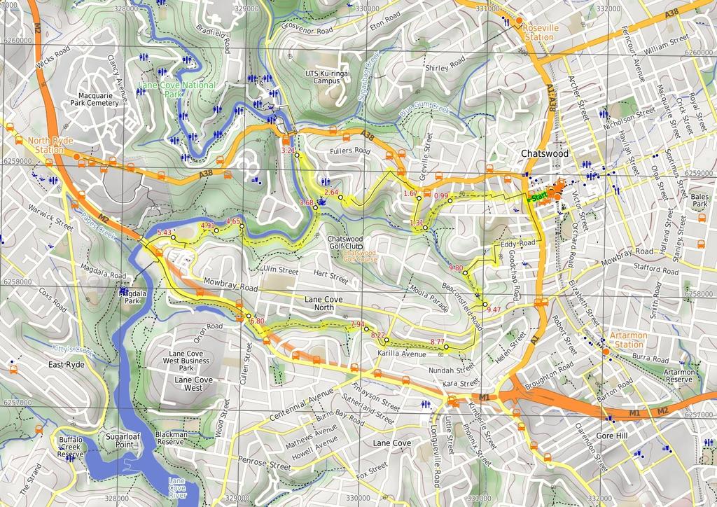
1 Rail to River and Stringybark Creek Reserve Walk 4 hrs Hard track 11.2 km Circuit 4 302m This walk begins in the busy city of Chatswood and soon enters the nearby bushland around the Lane Cove River. The walk uses the v-shaped valleys to escape from the houses. Due to pollution and rubbish in stormwater run-off there are some less then pleasant pockets, however, this walk does explore some wonderful views of the Lane Cove River and its surrounds. You can buy lunch at the Golf course, or there are plenty of nice spots along the river to stop and eat. 104m 1m Lane Cove National Park Maps, text & images are copyright wildwalks.com Thanks to OSM, NASA and others for data used to generate some map layers.

2 Chatswood Golf Course Before You walk The newly renovated deck at Chatswood Golf Course makes it a great place to take a breather on your walk. The club offers snacks and meals with a $12 all day breakfast on offer. Prices are reasonable, ranging from $5-20, with a good variety on offer. Chatswood Golf Course is open seven days for meals. More info. Bushwalking is fun and a wonderful way to enjoy our natural places. Sometimes things go bad, with a bit of planning you can increase your chance of having an ejoyable and safer walk. Before setting off on your walk check 1) Weather Forecast (BOM Metropolitan District) 2) Fire Dangers (Greater Sydney Region, unknown) 3) Park Alerts (Lane Cove National Park) 4) Research the walk to check your party has the skills, fitness and equipment required 5) Agree to stay as a group and not leave anyone to walk solo Think before you TREK The 'Think before you TREK' program developed by NSW Police & NPWS promotes the benefits of planning ahead for your bushwalking trip by using an easy to remember acronym: adequate supplies of food, water, navigation and first T Take aid equipment. your planned route and tell friends and family when R Register you expect to return. beacon (PLB's) should be carried on walks with E Emergency significant gaps in mobile coverage (check terrain profile). to your planned route and follow the map and walking K Keep trails. Topo Maps The maps provided on wildwalks are helpful, but there are times where you may need maps covering a broader area. Maps that cover this walk include; 1: Map Series:91303N PARRAMATTA RIVER 1: Map Series:9130 SYDNEY Grade This walk has been graded using the AS The overall grade of the walk is dertermined by the highest classification along the whole track. 4 Grade 4/6 Hard track Length 11.2 km Circuit Time 4 hrs Quality of track Formed track, with some branches and other obstacles (3/6) Signs Directional signs along the way (3/6) Experience Required Some bushwalking experience recommended (3/6) Weather Storms may impact on navigation and safety (3/6) Infrastructure Limited facilities, not all cliffs are fenced (3/6)
3 Are you ready to have fun? Please ensure you and your group are well prepared and equipped for all possible hazards and delays. Check park closures, weather information and Fire Danger Rating before setting out. Optional side trips and alternate routes noted are not included in this walks overall grade, length or time estimate. Please allow extra time for resting and exploring areas of interest. The authors, staff and owners of wildwalks take care in preparing this information but will not accept responsibility for any inconvenience, loss or injury you may experience. Please take care, have fun - Happy Walking. Getting there You can get to Chatswood Station (gps: , ) by car, train or bus. Car: There is free parking available. This is a circuit, so you will finish back at the start. Find up to date and more information inlcuding; travel directions, weather, park closures and walker feedback at Turn left: From Lowanna Park, this walk heads along Fullers Rd towards the mechanics, initially keeping the park on the left. The walk continues along Fullers Rd, as Millwood Ave breaks off to the right. The first left is the signposted intersection with Bellevue Ave. Turn left: From the intersection, this walk follows the 'Rail to River Walk' signs down Bellevue Ave for approximately 500m, tending right to the Turn left: From the intersection, this walk follows the 'Rail to River Walk' sign down the hill for approximately 30m to the telegraph pole with 'Rail to River Walk' sign. Turn right: From the intersection, the walk follows the 'Rail to River Walk' sign down the hill between the fences. The walk comes to the end of the laneway and descends the stairs, down through rocky outcrops to the O.H. Reid Memorial Oval. 0 Chatswood Station (990 m 20 mins) From Chatswood Train Station, this walk exits the station onto Victoria Ave. The walk then continues up Victoria Ave, passing Chatswood RSL on the left. This walk continues to the Pacific Highway where it crosses over the at a pedestrian crossing or the foot bridge near by. Turn right: From the intersection, this walk heads north up the Pacific Highway, to turn left onto Western Way. The walk continues down Western Way through a dogleg, turning right onto Jenkins Rd then quickly left back onto Western Way. The walk heads down Western Way to turn right onto Edgar St and to the Edgar Reserve Park with green gate. Turn left: From the intersection, the walk passes the gate, then the playground on the right, and continues through the clearing. The track continues for approximately 150m to an intersection marked by a memorial bench. Continue straight: From the intersection, the walk heads between the tennis court fence on your right and the houses on your left for approximately 150m. The track then comes to an intersection with Park Ave, and a 'Rail to River Walk' sign. Turn left: From the intersection, this walk follows the 'Rail to River Walk' sign down the road for approximately 30m to the next signpost Eastern side of O.H. Reid Memorial Oval (570 m 11 mins) Continue straight: From the intersection, the walk heads across the oval to the car park to the left of the toilet block. Continue straight: From the O.H. Reid Memorial Oval car park, this walk heads along the road with Chatswood Golf Course below on the left. The walk continues along the road for approximately 200m, passing a street on the left, to the intersection opposite house No. 17. Turn left: From the intersection opposite No. 17 Reid Drive, the walk heads down the stairs tending left down the hill to the signposted intersection behind the 8th tee Int. Park Ave and Rail to River Trk (320 m 8 mins) Turn right: From the intersection, the walk follows the 'Rail to River Walk' signpost past the 'Ferndale Park' sign, down the management trail. The walk continues along the trail for approximately 60m to a large grassed clearing. The walk then continues away from the clearing along a bush track, which soon comes to some steppingstones across the creek. Approximately 50m later, the walk comes to a Continue straight: From the intersection, the walk follows the creek (which remains on your left) down the gully for approximately 100m to the 1.31 Int. Ferndale Trk and Beresford Trk (360 m 9 mins) Veer right: From the intersection, the walk heads along the creek (which remains on the left) for approximately 60m to turn up the steps to a Turn right: From the intersection, this walk follows the 'Rail to River Walk' sign up the hill. The track zigzags up through mossy rock outcrops to a house on the left. This walk continues up the stairs to the intersection with the road. Veer right: From the intersection, this walk crosses the road and heads right, up the hill. The walk continues up the hill to Lowanna Park gate on the left Int. Lowanna Park and Greville St (960 m 19 mins) Turn left: From the gate on Greville St, this walk passes through the park diagonally, past the play equipment and BBQs, to the gate on the Fullers Rd side of Lowanna Park Int. Behind the 8th Tee (470 m 8 mins) Turn left : From the intersection, this walk follows the track past the metal fence and along the right-hand side of the 8th fairway of Chatswood Golf Course, keeping the river on the right of the track. The walk continues up the fairway and over a bridge, passing two sand bunkers on the left. Approximately 20m after the second bunker, the walk comes to an intersection with a management trail, on the right Chatswood Golf Course The newly renovated deck at Chatswood Golf Course makes it a great place to take a breather on your walk. The club offers snacks and meals with a $12 all day breakfast on offer. Prices are reasonable, ranging from $5-20, with a good variety on offer. Chatswood Golf Course is open seven days for meals. More info th Green (970 m 20 mins) Continue straight: From the intersection, this walk leaves the golf course and heads along the mangroves and waterline, to the right of the track. The walk follows the mangroves for a short time to the signposted intersection. Veer right: From the intersection, this walk follows the arrow for the 'River Walk', keeping the Lane Cove River on the right. The track continues along some boardwalk sections which are raised above the mangroves in places. The track continues to a Continue straight: From the intersection, this walk follows the 'River Track' sign, keeping the river below on the right. Large sections of track are suspended above the mangroves on a boardwalk. The track continues to wind along the Lane Cove River bank for approximately 400m to a signposted intersection Int. Avro Rd Trk and River Access Trk (260 m 4 mins) Continue straight: From the intersection, this walk heads west along the Lane Cove River bank, with the water to the right of the track. The track quickly opens out onto a clearing next to the river bank. The walk continues over two sections of boardwalked track, leading to a signposted intersection Int. River Trk and Upper Access Trk (520 m 11 mins) Turn right: From the signposted intersection, this walk heads towards the large rock next to the water (below on the right). The walk uses pins bolted into the rock as handholds, and climbs to the other side of the river bank. The track then continues along the gap between the mangroves and a rocky outcrop, to come to the Mowbray Park athletics field. Turn sharp left: From the oval's far corner, closest to the river and furthest from the road, this walk heads up the steps to the Turn right: From the intersection, this walk heads along the hillside towards the oval (below on the right). The track winds through the bush for approximately 60m to pass over a bridge and a 'Mowbray Park' sign in a grassed area. The walk crosses this grass area to come to the intersection with the footpath. Continue straight: From the park bench, this walk heads down the footpath, keeping the oval below on the right. The walk continues down the hill for a short time to soon come to the intersection to the side of the oval Mowbray car park (near oval) (1.4 km 25 mins) Veer left: From the car park, this walk heads away from the oval and towards the bridge near the river. The walk crosses the car park to then follow the railed pathway under the bridge. Here the walk bends left and heads up the stairs to the intersection with Epping Rd. Turn right: From the intersection, this walk heads along the shared footpath, keeping the traffic to your left. After about 100m, the walk crosses the factory driveway and comes to a set of traffic lights (opposite the end of Mowbray Rd). Continue straight: From the traffic lights, this walk heads uphill along the footpath beside Epping Rd to the first driveway entry to the large Shell petrol station. Continue straight: From the driveway, this walk heads up the hill along side Epping Rd, passing under a footbridge tothe traffic lights. Here the walk crosses Sam Johnson Way to the other side of the intersection. 6.8 Int. Epping Rd and Sam Johnson Way (1.1 km 21 mins) Veer right: From the intersection next to the pedestrian crossing, the walk heads down the stairs past the track marker. The track winds down the hill and tends left along the hillside for a short time before coming out under a bridge. The track heads under the bridge to the Continue straight: From the intersection, this walk follows the 'Murray St' sign along the creek bank, away from the bridge. The track passes through sections of rocks and ferns for approximately 700m before coming to an unmarked intersection on the left. Continue straight: From the intersection, this walk heads east along the creek (below on the right). The track winds through rocks and undulates for approximately 150m to an unmarked intersection on the left. Continue straight: From the intersection, this walk follows the 'Elizabeth Pde' arrow, undulating a little alongside the creek for approximately 150m, then turns right, up the hill, to the intersection with the road Int. Elizabeth Pde and Lower Stringybark Trk (280 m 5 mins) Turn sharp left: From the intersection, the walk heads up the hill along Elizabeth Pde, with the houses initially to the right. Soon, the walk passes the roundabout with Gordon Cr (on the left) and continues up to Centennial Ave. The walk turns left onto Centennial Ave, crossing the road as safe to the bush track, marked by an 'Upper Stringybark Creek Reserve' sign Int. Stringybark Trk and Centennial Ave

4 (550 m 9 mins) Turn right: From the intersection, this walk heads past the 'Upper Stringybark Creek Reserve' sign and down past a sandstone quarry interpretive sign. The track leads down and along the creek line for approximately 600m to then follow a boardwalked section of track for a short time. The walk comes to the end of the boardwalk after crossing the creek and meets the grassed park of Stringybark Reserve and some more interpretive signs. Veer right: From the intersection, this walk heads north up the grassed hill to the road, at the end of Murray St End of Murray St (700 m 13 mins) Turn right: From the intersection, the walk heads down Sharland Ave for approximately 150m to the park entrance on the left, marked by a signpost Sharland Ave entrance to Campbell Park (330 m 8 mins) Turn left : From the road, this walk passes through the top gate of Campbell Park and down along the footpath to the lower gate at Dalrymple Ave. Continue straight: From the entrance to Campbell Park, this walk crosses Dalrymple Ave into another grassy area marked by a 'Ferndale Park' sign. The track winds around to an interpretation sign which it passes to drop into a creek. The track then winds left along the side of a grassy clearing to follow the creek bank for approximately 50m along the back of some houses to the Continue straight: From the intersection, this walk heads down the hill to the next arrow and sign at the corner of the house. The track winds down a slight gradient for approximately 100m to a 9.8 Int. Ferndale Trk and Beresford Lane Trk (1.4 km 27 mins) Turn right: From the intersection, this walk heads up the laneway behind the houses. The path follows the blue markers for a short time to come to Beresford Ave, opposite Wallace Park Reserve. Turn sharp left: From the intersection, this walk heads up Lone Pine Ave to turn right onto Eddy Rd. The walk continues up to the end of the road, then turns left onto Pacific Highway. The walk passes the primary school and overpass, coming to the pedestrian crossing opposite Victoria Ave. Turn right: From the intersection, this walk crosses at pedestrian crossing on Pacific Highway, or takes the foot bridge just near the intersection. This walk then continues down Victoria Ave to the entrance of the train station on the right. If the road turns left, you have gone too far.
5
6 Summary navigation sheet for the Rail to River and Stringybark Creek Reserve Walk km From Start Chatswood Station , (GR Parramatta River, ) 0.99 Int. Park Ave and Rail to River Trk , (GR Parramatta River, ) 1.31 Int. Ferndale Trk and Beresford Trk , (GR Parramatta River, ) 1.67 Int. Lowanna Park and Greville St , (GR Parramatta River, ) 2.64 Eastern side of O.H. Reid Memorial Oval , (GR Parramatta River, ) 3.21 Int. Behind the 8th Tee , (GR Parramatta River, ) th Green , (GR Parramatta River, ) 4.65 Int. Avro Rd Trk and River Access Trk , (GR Parramatta River, ) 4.91 Int. River Trk and Upper Access Trk -33.8, (GR Parramatta River, ) 5.43 Mowbray car park (near oval) , (GR Parramatta River, ) 6.80 Int. Epping Rd and Sam Johnson Way , (GR Parramatta River, ) 7.94 Int. Elizabeth Pde and Lower Stringybark Trk , (GR Parramatta River, ) 8.22 Int. Stringybark Trk and Centennial Ave , (GR Parramatta River, ) 8.77 End of Murray St , (GR Parramatta River, ) 9.47 Sharland Ave entrance to Campbell Park , (GR Parramatta River, ) 9.80 Int. Ferndale Trk and Beresford Lane Trk , (GR Parramatta River, ) Powered by TCPDF ( Up/Dwn Length Initial directions (Use full tracknotes and maps for more detail) m 20 mins 320 m 8 mins 360 m 9 mins 960 m 19 mins 570 m 11 mins 470 m 8 mins 970 m 20 mins 260 m 4 mins 520 m 11 mins 1.4 km 25 mins 1.1 km 21 mins 280 m 5 mins 550 m 9 mins 700 m 13 mins 330 m 8 mins 1.4 km 27 mins From Chatswood Train Station, this walk exits the station onto Victoria Ave. Turn right: From the intersection, the walk follows the 'Rail to River Walk' signpost past the 'Ferndale Park' sign, down the management trail. Veer right: From the intersection, the walk heads along the creek (which remains on the left) for approximately 60m to turn up the steps to a Turn left: From the gate on Greville St, this walk passes through the park diagonally, past the play equipment and BBQs, to the gate on the Fullers Rd side of Lowanna Park. Continue straight: From the intersection, the walk heads across the oval to the car park to the left of the toilet block. Turn left : From the intersection, this walk follows the track past the metal fence and along the right-hand side of the 8th fairway of Chatswood Golf Course, keeping the river on the right of the track. Continue straight: From the intersection, this walk leaves the golf course and heads along the mangroves and waterline, to the right of the track. Continue straight: From the intersection, this walk heads west along the Lane Cove River bank, with the water to the right of the track. Turn right: From the signposted intersection, this walk heads towards the large rock next to the water (below on the right). Veer left: From the car park, this walk heads away from the oval and towards the bridge near the river. Veer right: From the intersection next to the pedestrian crossing, the walk heads down the stairs past the track marker. Turn sharp left: From the intersection, the walk heads up the hill along Elizabeth Pde, with the houses initially to the right. Turn right: From the intersection, this walk heads past the 'Upper Stringybark Creek Reserve' sign and down past a sandstone quarry interpretive sign. Turn right: From the intersection, the walk heads down Sharland Ave for approximately 150m to the park entrance on the left, marked by a signpost. Turn left : From the road, this walk passes through the top gate of Campbell Park and down along the footpath to the lower gate at Dalrymple Ave. Turn right: From the intersection, this walk heads up the laneway behind the houses.
Rail to River Walk. 3 hrs. Hard track 7.5 km Circuit. 222m
 Rail to River Walk 3 hrs Hard track 7.5 km Circuit 4 222m This walk is a great one from Chatswood Station to the Lane Cove River National Park. The walk descends through the vegetated bushland which fills
Hunters Hill to Epping Road
 Hunters Hill to Epping Road 2 hrs 30 mins 5.5 km One way Moderate track 154m An enjoyable walk through lower sections of the Lane Cove National Park, this walk features plenty of mangroves next to the
Currie Rd to Davidson Park
 Currie Rd to Davidson Park 3 hrs 7.2 km One way Moderate track 28m Starting at Currie Rd in Forestville, this walk follows Middle Harbour to Davidson Park, under Roseville Bridge. There are two optional
Epping to Pennant Hills Station (via Lane Cove River)
") Epping to Pennant Hills Station (via Lane Cove River) 3 hrs 5 mins 8.4 km One way Hard track 249m This walk, from Epping to Pennant Hills Station, is a great way to see the upper Lane Cove River Valley.
Epping to Pennant Hills Station (via Lane Cove River) 3 hrs 5 mins 8.4 km One way Hard track 249m This walk, from Epping to Pennant Hills Station, is a great way to see the upper Lane Cove River Valley.
Little Digger Track. 68m. 1 Hr 2.2 km One way. Moderate track 93m. Moores Creek Reserve
 Little Digger Track Hr 2.2 km One way Moderate track 93m This walk follows Moores Creek through several reserves in east Roseville and East Lindfield. The track is named after Australia's 7th Prime Minster,
Govetts Leap Loop. 1065m. 909m Blue Mountains National Park. 4 hrs 30 mins 8.7 km Circuit. Hard track 380m
 Govetts Leap Loop 4 hrs 30 mins 8.7 km Circuit Hard track 380m This walk, from Blackheath Train Station, is a fantastic way to see some of the iconic areas of the Blue Mountains in the Blackheath area.
Morgans Creek to Padstow
 Morgans Creek to Padstow 2 hrs 45 mins 8 km One way Moderate track 3 144m This pleasant walk starts from the Morgans Creek park, at Henry Lawsons Drive, and follows the Georges River past the Boomerang
Popes Glen, Pulpit Rock, Govetts Leap and Braeside Walk
 Popes Glen, Pulpit Rock, Govetts Leap and Braeside Walk 8 hrs Hard track 13.6 km Circuit 4 1068m This large circuit walk, from Popes Glen to Pulpit Rock, Govetts leap and along the Braeside Track, passes
Wentworth Falls Conservation Hut Loop
 Wentworth Falls Conservation Hut Loop 3 hrs Hard track 6.7 km Circuit 4 341m This scenic walk from Wentworth Falls Station, winds along the Nature Trail to Conservation Hut, then drops into the magnificent
Gordon to Chatswood Station
 Gordon to Chatswood Station 4 hrs 30 mins 12.2 km One way Hard track 4 381m This walk is a great way to get into the bush without being far from civilisation. The walk wanders through untouched valleys
Epping to Eastwood Station (via Lane Cove River)
") Epping to Eastwood Station (via Lane Cove River) hrs 45 mins 10.2 km One way Moderate track 189m Epping to Eastwood, via Lane Cove River, is the longer route through the bush between the stations. This
Epping to Eastwood Station (via Lane Cove River) hrs 45 mins 10.2 km One way Moderate track 189m Epping to Eastwood, via Lane Cove River, is the longer route through the bush between the stations. This
Heathcote to Engadine via Audley
 Heathcote to Engadine via Audley 6 hrs 3 mins 5 km One way Hard track 4 635m Covering a large section of central Royal National Park, this walk goes through the heath and scrub along a well managed and
Waterfall to Heathcote
 Waterfall to Heathcote 5 hrs Hard track 10.8 km One way 4 467m This walk explores the heart of Heathcote National Park, and is easily accessed with a train station at either end. Although relatively close
Little Digger Track to Davidson Reserve and Lyrebird Circuit
 Little Digger Track to Davidson Reserve and Lyrebird Circuit 4 hrs 3 mins 11.5 km One way Hard track 4 47m Exploring both the eastern and western sides of Middle Harbour Creek, this walk follows the Little
The Foreshore Walk. 24m. 1m Lake Macquarie LGA. 1 hr 15 mins 2.9 km One way. Hard track 81m
 The Foreshore Walk 1 hr 15 mins 2.9 km One way Hard track 81m This walk traverses the coastline of the Green Point reserve. By following a variety of tracks and occasionally traveling inland through eucalyptus
Teralba to Charlestown Park track head
 Teralba to Charlestown Park track head 4 hrs 30 mins 13.3 km One way Moderate track 3 220m This section of the Great North Walk starts from the Teralba train station and winds down and around the edge
Hornsby Blue Gum Walk
 Hornsby Blue Gum Walk 3 hrs Hard track 6.7 km Circuit 4 374m This delightful loop is one of the prettiest and most popular walks in the Hornsby area. Going from an environment of ferns and clear bushland
Balmoral Beach to The Spit
 Balmoral Beach to The Spit 2 hrs 30 mins.3 km One way Hard track 85m This walks follows the coast from Balmoral to the Spit and across Spit Bridge. There are some alternate tracks to consider at high-tides,
Wattamolla to Big Marley Beach
 Wattamolla to Big Marley Beach 4 hrs 10.4 km Circuit Moderate track 4m This walk is an excellent loop which takes in both the coast and the heathy inland of Royal National Park. Nearly the whole walk has
Echo Point to Leura Forest via Three Sisters and Giant Stairs loop
 Echo Point to Leura Forest via Three Sisters and Giant Stairs loop 3 hrs 3.8 km Circuit Hard track 512m This walk starts from the popular Echo Point, in Katoomba, and winds down to the base of the Three
Dead Horse Gap Loop track
 Dead Horse Gap Loop track 4 hrs 30 mins Hard track 9.8 km Circuit 144m 4 This walk starts with a ride up the Kosciuszko Express Chairlift. There is an opportunity to eat at Australia's highest restaurant,
Katoomba Falls Circuit
 Katoomba Falls Circuit hr 5 mins.5 km Circuit Hard track 59m For those looking for a walk involving more than simple boardwalk, this trail winding through the temperate rain forest could be just the thing.
Sid Pulsford Walk. 175m. 33m. 1 hr 45 mins 4.1 km One way. Hard track 118m. Gosford LGA
 Sid Pulsford Walk 1 hr 5 mins.1 km One way Hard track 118m Sid Pulsford Walk explores the ridge top of Kincumber Mountain, from Honeman's Rock to Green Point. The walk mostly follows wide management trails.
The Basin Track and Mackerel Track
 The Basin Track and Mackerel Track 3 hrs 5.9 km Circuit Hard track 226m This walk is a great way to see some popular areas in Ku-ring-gai Chase National Park. The walk from West Head Rd travels to The
Callicoma Loop. 174m. 98m. 2 hrs. Hard track 5.1 km Circuit. 153m
 Callicoma Loop 2 hrs Hard track 5.1 km Circuit 153m This great circuit walk passes through some really nice forest around the fringe of Cherrybrook. Highlights of the walk include some beautiful rock overhangs
Middle Harbour Creek Loop
 Middle Harbour Creek Loop 5 hrs 45 mins 15.1 km Circuit Experienced only 5 570m This walk explores the upper reaches of Middle Harbour Creek, starting and ending at the great parklands at Davidson Park,
Mackerel Beach, West Head Loop
 Mackerel Beach, West Head Loop 5 hrs 8.6 km Circuit Hard track 422m The Mackerel Beach, West Head Loop is a walk which explores a large part of the West Head. The journey starts and finishes with a ferry
Carrington Park to Leura Forest and pass loop
 Carrington Park to Leura Forest and pass loop 3 hrs Hard track 4.8 km Circuit 4 674m This walk is a fantastic way to see Leura Forest. The walk descends from Carrington Park, visiting Leura Forest and
Wallarah Coastal Walk
 Wallarah Coastal Walk 3 hrs 8.3 km Return Hard track 247m This walk starts at Caves Beach and travels south along the coastline, until reaching the Pinney s Headland Lookout. There are many opportunities
Woolwich Wharf to Boronia Park
 Woolwich Wharf to Boronia Park 2 hrs 5.8 km One way Moderate track 175m Going through the streets of Hunters Hill, this walk is on the first segment of the Great North Walk. The majority of the walk is
De Burgs Bridge to Thornleigh station
 De Burgs Bridge to Thornleigh station 3 hrs 45 mins 9.7 km One way Hard track 4 363m This walk follows a section of the Great North Walk, starting from De Burghs bridge. The walk winds north west, through
Mackerel Beach and Resolute Loop
 Mackerel Beach and Resolute Loop 3 hrs 5.4 km Circuit Hard track 384m This walk is another great walk in Ku-ring-gai Chase National Park, accessed by ferry. From the Mackerel Beach wharf, this walk uses
Bouddi Coastal Walk. 5 hrs. Hard track 8.1 km One way. 364m
 Bouddi Coastal Walk 5 hrs Hard track 8.1 km One way 4 364m This is one of the longer walks in the Bouddi National Park and it is rich in scenery. The walk follows the coastline with many side trips to
Epping to Gordon Station
 Epping to Gordon Station 4 hrs 15 mins 11.7 km One way Hard track 4 365m This walk, from Epping Station to Gordon Station, passes below the homes which sit on the hills high above the Lane Cove River.
De Burghs Bridge to Fullers Bridge
 De Burghs Bridge to Fullers Bridge 2 hrs 3 mins Hard track 6 km One way 2m 4 Following the Lane Cove River, this walk mostly follows a section of the Great North Walk and is well maintained and signposted.
Green Point Circuit Walk
 Green Point Circuit Walk 3 hrs 7.7 km Circuit Hard track 269m This walk visits all of the popular locations in Green Point Reserve, as well as some of the lesser-visited areas inland. Taking in Sea Eagle
Taronga Wharf to Chowder Bay
 Taronga Wharf to Chowder Bay 2 hrs 4.4 km One way Moderate track 246m Starting at Taronga Wharf, this walk passes many icons of Sydney, including Taronga Zoo, HMAS Sydney Mast, Chowder Bay. The walk also
Blackheath Station to Junction Rock Loop (via Grand Canyon and Popes
 Blackheath Station to Junction Rock Loop (via Grand Canyon and Popes 8 hrs 30 mins 18.2 km Circuit Hard track 4 1254m This circuit starts in Blackheath and heads down into the Grand Canyon and Rodriguez
Spit Bridge to Middle Head Forts
 Spit Bridge to Middle Head Forts 2 hrs 30 mins 6.3 km One way Hard track 4 181m This scenic walk takes you from the Spit Bridge, along the coast to explore the Middle Head Forts. There are a few alternate
Upper Rumbalara circuit
 Upper Rumbalara circuit 1 hr 30 mins 3.3 km Circuit Hard track 176m A great circuit walk, covering most of the walking tracks and sights in the upper section of the Rumbalara Reserve. There is some really
Scenic World to Echo Point
 Scenic World to Echo Point 1 hr 15 mins 2.1 km One way Moderate track 192m This is one of the most popular tourist walks in the Katoomba area. The walk follows the cliffs along a well maintained and signposted
Campbell Drive to Snapper Point
 Campbell Drive to Snapper Point 1 hr 45 mins 4.2 km One way Experienced only 135m This walk follows the Coast Track to Frazer Beach, along the Geebung and (overgrown) Grass Tree Tracks. From the northern
Roseville to Macquarie Park
 Roseville to Macquarie Park 3 hrs 3 mins 8.8 km One way Hard track 4 29m This walk starts at Roseville station and explores the streets and alleyways of Roseville before joining the main spine of the Great
Sphinx, Warrimoo and Bobbin Head tracks
 Sphinx, Warrimoo and Bobbin Head tracks 4 hrs 9.6 km Circuit Moderate track 499m This great walk starts at the Sphinx Memorial and loops around via Cowan Creek, exploring diverse environments as it changes
Chatswood to Epping Station
 Chatswood to Epping Station 6 hrs Hard track 16.3 km One way 4 533m This walk, from Chatswood to Epping, is a long but enjoyable walk along the Lane Cove valley. The walk mostly follows the Lane Cove River
Under and Over Cliff Walk
 Under and Over Cliff Walk 4 hrs 9.4 km Circuit Moderate track 576m This walk from Wentworth Falls Station is a fantastic way to see a large majority of the Wentworth Falls cliffline. The track winds under
National Pass from Wentworth Falls to Conservation Hut
 National Pass from Wentworth Falls to Conservation Hut 3 hrs Hard track 3.6 km One way 739m Starting at Wentworth Falls picnic area, this scenic and historic walk explores many waterfalls, lookouts and
Wentworth Falls Station Loop (Undercliff Walk)
") Wentworth Falls Station Loop (Undercliff Walk) 4 hrs 3 mins Hard track 8.9 km Circuit 658m 4 This walk passes some stunning waterfalls and views into the Jamison Valley, following the cliff edges around
Wentworth Falls Station Loop (Undercliff Walk) 4 hrs 3 mins Hard track 8.9 km Circuit 658m 4 This walk passes some stunning waterfalls and views into the Jamison Valley, following the cliff edges around
Berowra to Mt Kuring-gai
 Berowra to Mt Kuring-gai 4 hrs 30 mins 9.4 km One way Hard track 4 551m From the ridges above Cowan Creek, this walk takes in some great lookouts (especially around Mt Kuringgai) as well as enjoying an
Glenbrook and Euroka Circuit
 Glenbrook and Euroka Circuit 2 Days 16.6 km Circuit Experienced only 790m This two day circuit, returning to Glenbrook Station, is a scenic walk which passes many of the tourist attractions within the
North Ryde Fairyland circuit
 North Ryde Fairyland circuit 2 hrs 30 mins Hard track 6.9 km Circuit 193m 4 Starting at North Ryde train station this walk explores a stretch of the Lane Cove River, visiting the historic Fairlylands Pleasure
Patonga to Woy Woy. 5 hrs 45 mins 15.5 km One way. Hard track. 497m
 Patonga to Woy Woy 5 hrs 45 mins 15.5 km One way Hard track 4 497m This walk explores a variety of environments from the shore line and coastal cliffs near Patonga, to the dry, rocky and open ridge line.
Lane Cove Tourist Park River Circuit
 Lane Cove Tourist Park River Circuit 5 hrs 12 km Circuit Hard track 383m This walk follows a large section of Lane Cove River. The walk follows the Riverside Walking track up the Lane Cove River to De
Dubbo Gully and Ten Mile Hollow Circuit (via Clares Bridge)
") Dubbo Gully and Ten Mile Hollow Circuit (via Clares Bridge) 2 Days Hard track 24.3 km Circuit 4 1117m This two day (or ten hour) walk follows several historic roads, now closed to traffic. Starting with
Dubbo Gully and Ten Mile Hollow Circuit (via Clares Bridge) 2 Days Hard track 24.3 km Circuit 4 1117m This two day (or ten hour) walk follows several historic roads, now closed to traffic. Starting with
Hermitage Foreshore Track
 Hermitage Foreshore Track 1 Hr 2.2 km One way Moderate track 123m The Hermitage Foreshore Walk is a wonderful way to explore Sydney Harbour from the perspective of South Head. This walk starts from Nielsen
Thornleigh to Hornsby
 Thornleigh to Hornsby 4 hrs Hard track 10.2 km One way 4 526m Starting at Thornleigh station you walk through suburban streets for a short while before diving into the bush at the southern end of Berowra
Wentworth Falls Station Loop
 Wentworth Falls Station Loop 5 hrs 3 mins 9.5 km Circuit Hard track 4 13m The Wentworth Falls Station Loop takes in most of the upper tracks around Wentworth Falls. There are many scenic views near the
Faulconbridge to Blaxland
 Faulconbridge to Blaxland 2 Days Experienced only 15.2 km One way 5 693m This two-day walk, or very solid one-day walk, takes you from station to station, through lush, scenic forest in the lower Blue
Charlestown Park trackhead to Newcastle station
 Charlestown Park trackhead to Newcastle station 5 hrs 30 mins 12.1 km One way Hard track 4 287m This section of the Great North Walk starts from the Charleston Park track head and winds through the streets
Rumbalara Explorer. 158m. 5m Rumbalara Reserve. 2 hrs 45 mins 6.1 km Circuit. Hard track 326m
 Rumbalara Explorer 2 hrs 5 mins 6.1 km Circuit Hard track 326m Pretty well the grand tour of the Rumbalara Reserve, this walk takes in much of the great scenery the reserve has to offer. The walk covers
Bouddi Ridge and Coastal Walk
 Bouddi Ridge and Coastal Walk 2 Days Hard track 27 km Circuit 4 126m This overnight walk takes in the majority of the magnificent Bouddi National Park. The walk starts from the pleasant Putty Beach camping
Echo Point to Leura Forest Circuit
 Echo Point to Leura Forest Circuit 3 hrs 4.8 km Circuit Hard track 588m Forming a circuit around the cliffs and then the valley floor, this is a walk more then capable of convincing a walker of the beauty
Wentworth Falls Loop. 893m. 665m. 6 hrs 10.2 km Circuit. Hard track 1093m. Blue Mountains National Park
 Wentworth Falls Loop 6 hrs 1.2 km Circuit Hard track 193m This is a great walk, both in size and spectacular views. The walk makes its way from Wentworth Falls train station and drops off the plateau,
Sphinx to Mt Kuring-gai
 Sphinx to Mt Kuring-gai 4 hrs 45 mins 1.7 km One way Hard track 673m This walk starts at the Sphinx War Memorial and follows some well maintained and popular walking tracks down to Cowan Creek. Enjoy the
Federal Pass Walking Track
 Federal Pass Walking Track 5 hrs Hard track 8 km One way 4 989m This classic trail follows along the base of the cliffs from Leura to the Golden Stairs, passing many of the more popular sights of the Katoomba
Gosford to Lisarow. 202m
 Gosford to Lisarow 4 hrs 3 mins Hard track 11.3 km One way 4 479m This walk is a great way to explore the ridge-top bushland between Gosford and Lisarow. Passing through Rumbalara and Katandra Reserves,
Spit Bridge to Manly (Manly Scenic Walkway)
") Spit Bridge to Manly (Manly Scenic Walkway) 3 hrs 45 mins 9.1 km One way Moderate track 349m The Spit to Manly walk is a classic bushwalk on Sydney's Northern Beaches. The walk follows a well-maintained
Spit Bridge to Manly (Manly Scenic Walkway) 3 hrs 45 mins 9.1 km One way Moderate track 349m The Spit to Manly walk is a classic bushwalk on Sydney's Northern Beaches. The walk follows a well-maintained
Manly to Seaforth Oval
 Manly to Seaforth Oval 5 hrs 45 mins 13.7 km One way Moderate track 3 624m This walk follows the Manly to Spit Scenic Walkway, then continues past The Spit Bridge to Seaforth Oval. The walk provides magnificent
Bobbin Head Loop. 166m. 0m Ku-ring-gai Chase National Park. 5 hrs 12.9 km Circuit. Hard track 619m
 Bobbin Head Loop 5 hrs 12.9 km Circuit Hard track 619m This great circuit walk enjoys a variety of landscapes in Ku-ring-gai Chase National Park. The walk starts at the historic Sphinx war memorial and
Taronga Zoo to Spit Bridge
 Taronga Zoo to Spit Bridge 5 hrs Hard track 1.4 km One way 4 41m This is a scenic and culturally rich walk with views over Sydney Harbour and many interesting heritage buildings along the way. The start
The Coast Track. 2 Days. Hard track 27.4 km One way. 1351m
 The Coast Track 2 Days Hard track 27.4 km One way 4 1351m Heading south, this walk covers the coastline of the Royal National Park and can truly only be described as amazing. With breathtaking coastal
Cape Banks Circuit. 50m. 2m Botany Bay National Park. 3 hrs 7.3 km Circuit. Hard track 190m
 Cape Banks Circuit 3 hrs 7.3 km Circuit Hard track 19m This Cape Banks Circuit has a lot to offer and is thoroughly recommended. The walking travels over beaches, through coastal forest and across exposed
Scenic world to Three Sisters Loop via Furber Steps
 Scenic world to Three Sisters Loop via Furber Steps 5 hrs 5.8 km Circuit Hard track 722m This walk starts from the popular Scenic World, in Katoomba, and winds down the Furber steps into the Jamison Valley,
Narrabeen Lagoon Trail (from Middle Creek)
") Narrabeen Lagoon Trail (from Middle Creek) 2 hrs 30 mins 8.6 km Circuit Very easy 1 105m The Narrabeen Lagoon Trail is a wonderful and accessible walk on the Northern Beaches of Sydney. The trail is used
Narrabeen Lagoon Trail (from Middle Creek) 2 hrs 30 mins 8.6 km Circuit Very easy 1 105m The Narrabeen Lagoon Trail is a wonderful and accessible walk on the Northern Beaches of Sydney. The trail is used
Light to Light Walk 2 days
 Light to Light Walk 2 days 2 Days Hard track 3.9 km One way 4 794m Over two days, this classic walk explores the coast from Boyd Tower to the Green Cape Lighthouse in the south. Hegartys Bay Camp is over
Sydney to Thornleigh via Lane Cove Tourist Park
 Sydney to Thornleigh via Lane Cove Tourist Park 2 Days 33 km One way Hard track 4 1114m This overnight walk starts from the Obelisk in Macquarie Park, Sydney, at the official start of the Great North Walk.
Six Foot Track. 1212m
 Six Foot Track 3 Days 44.8 km One way Hard track 4 2066m This classic walk takes you from Katoomba to Jenolan Caves via a historic horse route. The walk travels mainly along well-maintained service tracks
MELBOURNE MIDDAY MILERS MARCH MADNESS BARWON HEADS 5MS RELAY
 MELBOURNE MIDDAY MILERS MARCH MADNESS BARWON HEADS 5MS RELAY 2013 Pre-race admin 1. We will meet at 8.15am on Sunday 17 March in the car park opposite the Barwon Heads Hotel & fronting the beach on Ewing
Start / Finish. Version 2
 Start / Finish Version 2 Gosford (Start) to Woy Woy Head South down Etna Street, crossing Henry Parry Drive, then Mann St, Gosford, where Etna St becomes Racecourse Road. Follow this road all the way
MAPS & WALK NOTES. DAY 2: Greenwich Wharf to Woolwich Wharf
 MAPS & WALK NOTES DAY 2: Greenwich Wharf to Woolwich Wharf Total Distance: 15.5km Time: Approximately 5 hours 30 mins five Sections Walk Notes in Section Name Length Time 2:1 Greenwich Wharf to Northwood
Route: Skewsby Foulrice Stearsby
 Route: Skewsby Foulrice Stearsby Distance: 7 miles Map: Explorer: 300 Howardian Hills & Malton Start (OS ref): SE625710 Park in the village of Skewsby. Walk east out of the village to the T-Junction and
The Year Of Mercy Pilgrimage Sts Peter and Paul s Church, Bulimba To The Cathedral of St Stephen
 The Year Of Mercy Pilgrimage Sts Peter and Paul s Church, Bulimba To The Cathedral of St Stephen Dist Route Photos Photos 0.0km St Peter and Paul s Church, 235 Riding Rd & Cnr Main Ave, Balmoral. http://www.bulimbacatholic.com/
RILLINGTON TO MALTON by Tania Dickinson
 RILLINGTON TO MALTON by Tania Dickinson This walk takes you from the Vale of Pickering up on to the Wold scarp, before dropping down again through the pretty village of Settrington and joining the Centenary
A Walk from Our Lady of Victories Church, Bowen Hills to The Cathedral of Saint Stephen
 A Walk from Our Lady of Victories Church, Bowen Hills to The Cathedral of Saint Stephen 1 0.0km 30m 185m 270m From the Start to Breakfast Creek Rd is 8 minutes This pilgrimage walk should take the average
Harbour Bridge to Taronga Zoo
 Harbour Bridge to Taronga Zoo 4 hrs 9.8 km One way Moderate track 389m On this walk, you will explore much of the foreshore linking Milsons Point Station to Taronga Zoo Ferry wharf. The walk is mostly
LDWA SOUTH DOWNS MARATHON 13 th MAY 2018
 AHD ahead SDW South Downs Way BL/BR bear left/bear right TL/TR turn left/turn right X cross LEG 1 - EAST DEAN to WP1 NORTON GR 470019. Open 1030 to 1300. 9.7 miles. 1.1 From village hall TL and walk to
Hexham Abbey to the Racecourse Road
 Hexham Abbey to the Racecourse Road The Yarridge Road, or Racecourse Road as it is often known, runs along the ridge line to the south of Hexham and provides wonderful views of the river valley and fells
WETHERBY CIRCULAR by Tania Dickinson
 WETHERBY CIRCULAR by Tania Dickinson This walk in lower Wharfedale includes a disused railway line at the beginning and riverside at the end, with parkland, fields, woodland and villages in between. Distance
The Mendip Way. Route Directions and Maps Wells to Frome
 The Mendip Way Route Directions and Maps Wells to Frome Website: www.mendiphillsaonb.org.uk Email: mendip@mendiphillsaonb.org.uk Facebook & Twitter: @MendipHillsAONB Phone: 01761462338 1 Wells to Shepton
The Hundred Parishes
 The Hundred Parishes Walks from railway stations number 9 6.4 miles (10kms) from Bishop s Stortford to Stansted Mountfitchet Start: Bishop s Stortford station (Grid Reference TL492209) (ample parking and
ULTRA-TRAIL AUSTRALIA May 2018 COURSE DESCRIPTION AND COURSE NOTES
 ULTRA-TRAIL AUSTRALIA 100 19-20 May 2018 COURSE DESCRIPTION AND COURSE NOTES LEG 1 Scenic World (Start) to Narrow Neck (Checkpoint 1) Course Description: From the start, at the front entrance of Scenic
Times. S E S/Rd(E) Wakefield Road) Wakefield Rural Fire Brigade
 Wakefield Road) Wakefield Rural Fire Brigade") START On York Street, Teralba adjacent to Tulkaba Park Sports Pavilion (on leaving travel west on York Street) [EEP-1A] Position* Altitude Distance (km)* Trail S32 57.593 E151 36.520 21 0.5 0.5 S/Rd(E)
START On York Street, Teralba adjacent to Tulkaba Park Sports Pavilion (on leaving travel west on York Street) [EEP-1A] Position* Altitude Distance (km)* Trail S32 57.593 E151 36.520 21 0.5 0.5 S/Rd(E)
THE WELLDIGGERS ARMS, HESWORTH AND FITTLEWORTH TRAIL
 THE WELLDIGGERS ARMS, HESWORTH AND FITTLEWORTH TRAIL 5.5 miles Circular 3 hours 041017 Challenging Terrain A 300-year-old pub turned country-inn on the edge of the South Downs National Park, The Welldiggers
Hammer Vale and Linchmere Common
 point your feet on a new path Hammer Vale and Linchmere Common Distance: 9 km=5½ miles or 6 km=3¾ miles easy walking with one steep section Region: Hampshire, West Sussex Author: Botafuego Refreshments:
LDWA SOUTH DOWNS MARATHON
 AHD ahead SDW South Downs Way BL/BR bear left/bear right TL/TR turn left/turn right SP signpost/fingerpost X cross LEG 1 - EAST DEAN to WP1 NORTON GR 470019. Open 1030 to 1300. 9.6 miles. 1.1 From village
Dyrham and Hinton Parish Walks
 Dyrham and Hinton Parish Walks A series of five walks in the parish, exploring most of the public footpaths. By John Miller Each walk is described in detail, with a complete map, to provide a handy guide
Traffic Signs and Signals
 CHAPTER FOUR Traffic Signs and Signals Traffic signs control traffic flow, making streets and highways safer for drivers, bicyclists and pedestrians. These signs, which are posted by the Indiana Department
BALCOMBE AND ARDINGLY RESERVOIR, WEST SUSSEX
 BALCOMBE AND ARDINGLY RESERVOIR, WEST SUSSEX 7 miles Circular 4 hours 080816 Challenging Terrain Hi, I'm Luke and this is my West Sussex Weekends walk It's a 7 mile loop from Balcombe rail station, taking
Dorridge & District Residents Association A Walk Along The Green Belt From Dorridge to Catherine-de-Barnes
 Dorridge & District Residents Association A Walk Along The Green Belt From Dorridge to Carine-de-Barnes The starting section of this walk through open fields would be destroyed by building of motorway
EXECUTIVE SUMMARY Callan Park accommodates travel from a wide range of transport modes, including walking, cycling, bus and light rail.
 TRANSPORT AND ACCESS EXECUTIVE SUMMARY Callan Park accommodates travel from a wide range of transport modes, including walking, cycling, bus and light rail. Whilst there are some walking facilities within