Under and Over Cliff Walk
|
|
|
- Austen Chambers
- 5 years ago
- Views:
Transcription


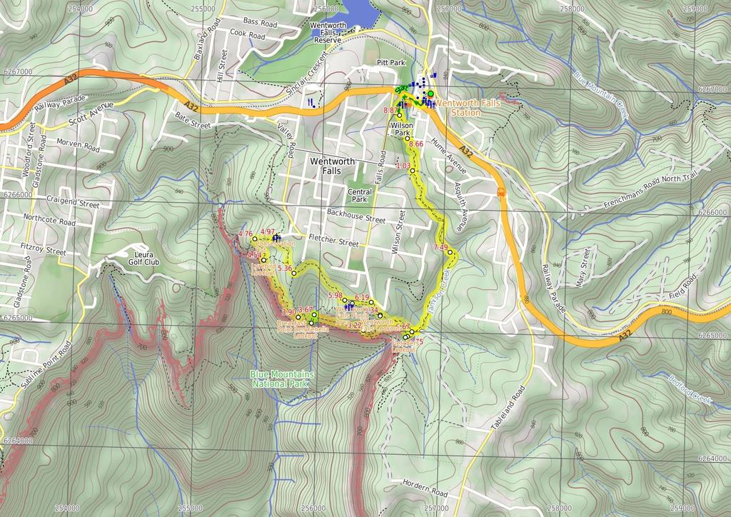
1 Under and Over Cliff Walk 4 hrs 9.4 km Circuit Moderate track 576m This walk from Wentworth Falls Station is a fantastic way to see a large majority of the Wentworth Falls cliffline. The track winds under and over the cliffs, giving different perspectives of the the Jamison Valley below and waterfalls along the way. Conservation Hut marks the turn-around point for this walk and is a great place to grab some lunch or a coffee for continuing back to the station m 893m Maps, text & images are copyright wildwalks.com Thanks to OSM, NASA and others for data used to generate some map layers. Blue Mountains National Park

2 Fletchers Lookout Fletchers Lookout is a fenced and signposted lookout off the side of the Undercliff Walk, just north of the Wentworth Falls. The lookout provides a fairly close view of the top of Wentworth Falls and a great view into the Jamison Valley. There is a good distant view of Mount Solitary and Narrow Neck, and also great views of the surrounding escarpments. Den Fenella Lookout The Den Fenella Lookout is a small fenced lookout on a cliff ledge, near where Den Fenella Creek falls into the Jamison Valley. The lookout is at the end of the track and has a tall cliff above and below. There is a small tree on the ledge adding to the sense of depth. From here, there are great views to Mount Solitary (middle), Kings Tableland (left), Narrow Neck Plateau (far right) and Sublime Point (right). This is a great spot, well worth a visit. Breakfast Point Lookout Breakfast Point Lookout is on the Overcliff Walk, west of Den Fenella Creek. The lookout has a short stone wall and great views across the Jamison Valley. The center piece of the view is out to Mount Solitary and beyond, there are also good views to Kings Tableland (left). This is a good spot to stop and enjoy the sweeping views of the majestic valley. Lyrebird Lookout Lyrebird Lookout is a fenced and signposted lookout on the Overcliff Walk, south of the Conservation Hut in the Blue Mountains National Park. The lookout hosts a great view of Sublime Point (right) and Mount Solitary (centre). A welcome gap in the trees reveals this great view. Conservation Hut Conservation Hut is a small cafe perched above the Valley of the Waters, Blue Mountains National Park. The hut was opened in 1963 as a meeting place for the local conservation movement. Rebuilt, Conservation Hut opened as a cafe in 1993, serving breakfast, lunch and dinner, seven days a week. Around the Conservation Hut is a small parking area, public toilets, picnic shelters, town water and B&B's. For further information or bookings call (02) More info. Before You walk Bushwalking is fun and a wonderful way to enjoy our natural places. Sometimes things go bad, with a bit of planning you can increase your chance of having an ejoyable and safer walk. Before setting off on your walk check 1) Weather Forecast (BOM Central Tablelands District) 2) Fire Dangers (Greater Sydney Region) 3) Park Alerts (Blue Mountains National Park) 4) Research the walk to check your party has the skills, fitness and equipment required 5) Agree to stay as a group and not leave anyone to walk solo Think before you TREK The 'Think before you TREK' program developed by NSW Police & NPWS promotes the benefits of planning ahead for your bushwalking trip by using an easy to remember acronym: T R E K Take adequate supplies of food, water, navigation and first aid equipment. Register your planned route and tell friends and family when you expect to return. Emergency beacon (PLB's) should be carried on walks with significant gaps in mobile coverage (check terrain profile). Keep to your planned route and follow the map and walking trails. Topo Maps The maps provided on wildwalks are helpful, but there are times where you may need maps covering a broader area. Maps that cover this walk include; 1: Map Series:89301S KATOOMBA 1: Map Series:8930 KATOOMBA Grade This walk has been graded using the AS The overall grade of the walk is dertermined by the highest classification along the whole track. 3 Length Time Quality of track Grade 3/6 Moderate track 9.4 km Circuit 4 hrs Formed track, with some branches and other obstacles (3/6) Signs Directional signs along the way (3/6) Experience Required Weather Infrastructure Some bushwalking experience recommended (3/6) Storms may impact on navigation and safety (3/6) Limited facilities, not all cliffs are fenced (3/6)
3 Are you ready to have fun? Please ensure you and your group are well prepared and equipped for all possible hazards and delays. Check park closures, weather information and Fire Danger Rating before setting out. Optional side trips and alternate routes noted are not included in this walks overall grade, length or time estimate. Please allow extra time for resting and exploring areas of interest. The authors, staff and owners of wildwalks take care in preparing this information but will not accept responsibility for any inconvenience, loss or injury you may experience. Please take care, have fun - Happy Walking. Getting there You can get to Wentworth Falls Railway Station (gps: , ) by car, train or bus. Car: There is free parking available. This is a circuit, so you will finish back at the start. Find up to date and more information inlcuding; travel directions, weather, park closures and walker feedback at 0 Wentworth Falls Railway Station (490 m 9 mins) From Wentworth Falls Railway Station, this walk exits the station on the western side, on Station St, and turns left to head down to the Great Western Highway past the shops. At the highway, the walk crosses at the lights and turns right, heading down the hill along the foot path. This walk then turns left into Wilson Park soon after the colourful bus stop. The walk follows the footpath through Wilson Park. At the toilet block in the centre of the park, the walk tends slightly more to the left until coming to a large archway entrance to the Charles Darwin Walk, near the tennis courts Wilson Park (540 m 12 mins) Continue straight: From the south-east corner of Wilson Park (near the tennis courts), this walk heads under the large wooden archway signposted as 'Charles Darwin Walk'. The walk follows the track passing a blue sign pointing to 'Wentworth Falls Waterfall' and soon after crosses the creek on a small wooden bridge. On the other side of the creek the track meanders through the open pine forest. After heading up some steps the track comes to an intersection with a sign pointing back to 'Wilson Park' (the steps on the left head up to Page Ave). Continue straight: From the intersection, this walk passes the blue sign (on the right) and turns right down the steps to immediately come to an intersection just before the bridge (and a 'Charles Darwin Walk' sign). Turn left: From the intersection, this walk follows 'Charles Darwin walk' sign downstream, keeping the creek on the right. The track meanders alongside the creek over some timber platforms and through a lovely Banksia grove. Soon the track heads under a pipe bridge and comes to a clearing and intersection Int of Charles Darwin and Parkes St Tracks (840 m 17 mins) Continue straight: From the intersection near the pipe bridge, this walk follow the 'Wentworth Falls Waterfall' sign downstream (keeping the creek on the right). The walk soon passes another track (that crosses the creek using a small bridge on the right) and then passes a bush regeneration sign to leave the clearing. The track meanders alongside the creek for a while before heading down some stairs and crossing the creek on a bridge. On the other side the walk passes a bench seat and then comes to an intersection with the signposted 'Parkes Street' track (on the right). From this intersection, this walk heads downstream (keeping the creek to the left). The walk crosses the creek on a foot bridge and follows the creek closely soon passing a beautiful set of cascades. After cascades, the walk goes down a steep section of stairs and once again crosses the creek. The track continues along a section of boardwalk before joining up with a track that continues beside the creek. This goes along a mixture of boardwalk and bush track until coming to an intersection with a track, with 'Fletcher St' and 'Falls' signs Int of Charles Darwin and Fletcher St Tracks (880 m 16 mins) Continue straight: From the intersection, this walk follows the creek downstream along a mixture of bush track and boardwalk. The track continues down until crossing two small creeks. Soon after these two small creeks, the track comes to an intersection, with 'Wentworth Falls' and 'National Pass Trail' signs. Veer right: From the intersection, this walk heads up the steps following the 'Wentworth Falls Picnic Area' sign (keeping the valley to the left). Soon, the track comes to an intersection with a sign pointing back to 'Weeping Rock Circuit'. Turn left: From the intersection, this walk follows the 'Wentworth Falls' sign down the track. The track soon steepens, heading down the steps and then coming to a four-way intersection, opposite a short track to 'Fletchers Lookout' Optional sidetrip to Fletchers Lookout (20 m 1 mins) Continue straight: From the intersection, this walk follows the 'Fletcher Lookout' sign down the steps. The fenced and signposted lookout has three main bays, two on the left (with views of Wentworth Falls) and a third down the steps, looking into the valley. At the end of this side trip, retrace your steps back to the main walk then Turn left Fletchers Lookout Fletchers Lookout is a fenced and signposted lookout off the side of the Undercliff Walk, just north of the Wentworth Falls. The lookout provides a fairly close view of the top of Wentworth Falls and a great view into the Jamison Valley. There is a good distant view of Mount Solitary and Narrow Neck, and also great views of the surrounding escarpments Int of Undercliff and Fletchers Lookout Tracks (470 m 22 mins) Turn right: From the intersection, this walk follows the 'Undercliff walk' sign, keeping the main valley to the left. The track soon passes under three significant and low overhangs (be sure to duck) each with wide sweeping left-hand bends. The first overhang has timber blocks on the floor. Soon after the third overhang, the track comes to a point with a large dead tree and some great valley views. From the view, this walk keeps the rock wall on the right and soon turns right, passing through a large overhang. On the other end of this overhang, the track comes to an unsignposted 'Y' intersection. (The lower left-hand track heads down to Eagles Nest Lookout.) From the intersection, this walk follows the higher track (keeping the valley view to the left). The track soon bends right, heads up some steps and passes under a large overhang. Soon after this overhang, the walk heads up some steps then comes to a three-way intersection with the 'Princes Rock' track (on the right) and a 'Wentworth Falls' sign pointing back Int of Undercliff and Princes Rock Tracks (460 m 13 mins) Continue straight: From the intersection, this walk follows the 'Valley of the Waters' sign along the track (with filtered views into the valley on the left). The walk soon crosses a small metal bridge and comes to a fenced (unnamed) lookout with great valley views. The walk follows the track back into the bush as it heads around the valley, soon coming to a sandstone overhang with a constructed stone wall, and more great valley views. From the overhang, the walk continues around the cliff wall, down the metal steps and along the base of the cliff. After passing an interesting rock formation, the track heads through a muddy section then soon bends right. The walk then heads down some steps and soon comes to an intersection just before a footbridge, with a sign pointing back to the 'Undercliff Walk'. Turn left: From the intersection, this walk crosses over Den Fenella Creek using the bridge and comes to an intersection at the 'Den Fenella' sign Optional sidetrip to Den Fenella Lookout (70 m ) Veer left: From the intersection, this walk follows the 'Den Fenella' sign along the lower track, keeping the creek to the left. The track soon begins to go down very steeply (can be slippery) between the handrails and rock wall. The track then crosses the creek at the stepping stones below the cascades (the creek may be impassable after rain). On the other side of the creek, the walk heads down the steps to come to a bridge below the bigger Den Fenella Fall. From the Den Fenella Fall, this walk crosses the metal bridge and continues along the cliff edge along the fence-lined track. After heading down some steps, the track ends at a fenced point with great views across the valley. At the end of this side trip, retrace your steps back to the main walk then Turn left Den Fenella Lookout The Den Fenella Lookout is a small fenced lookout on a cliff ledge, near where Den Fenella Creek falls into the Jamison Valley. The lookout is at the end of the track and has a tall cliff above and below. There is a small tree on the ledge adding to the sense of depth. From here, there are great views to Mount Solitary (middle), Kings Tableland (left), Narrow Neck Plateau (far right) and Sublime Point (right). This is a great spot, well worth a visit Int of Overcliff and Denfenella Lookout Track (230 m 12 mins) Veer right: From the intersection, this walk heads away from the bridge following the higher track. After about 100m, the track turns right at the next intersection. (The left-hand track heads down to the Lady Sees lookout with a fence in disrepair, currently closed). Soon this walk heads up some steps (around some large boulders) before meandering through the bush for some time. After a little while, the track comes to a three-way intersection and the unsignposted Breakfast Point Lookout. 3.9 Breakfast Point Lookout Breakfast Point Lookout is on the Overcliff Walk, west of Den Fenella Creek. The lookout has a short stone wall and great views across the Jamison Valley. The center piece of the view is out to Mount Solitary and beyond, there are also good views to Kings Tableland (left). This is a good spot to stop and enjoy the sweeping views of the majestic valley. 3.9 Breakfast Point Lookout (640 m 21 mins) Continue straight: From Breakfast Point Lookout, this walk follows the Overcliff Track west, keeping the valley views to the left. The track soon passes an informal track (on the left) before heading along the base of a large rock wall (on the right). The track then heads up the steps following the handrail - soon after the end of the handrail, the track passes another informal track (on the left). After passing an often muddy section of track, this walk turns left at the intersection, then heads a few meters to the fenced and signposted 'Lyrebird Lookout' Lyrebird Lookout Lyrebird Lookout is a fenced and signposted lookout on the Overcliff Walk, south of the Conservation Hut in the Blue Mountains National Park. The lookout hosts a great view of Sublime Point (right) and Mount Solitary (centre). A welcome gap in the trees reveals this great view Lyrebird Lookout (220 m 6 mins) Continue straight: From Lyrebird Lookout, this walk keeps the green fence to the left and follows the track into the bush (with the valley behind and to the left). The walk crosses a section that is normally wet and muddy, and soon comes to a unsignposted 'Y' intersection with the Lyrebird Cliff Track on the left. Continue straight: From the intersection, this walk takes the upper track and heads north-west. This goes up slightly before flattening out and continuing away from the cliffs, until coming to an intersection with a well-managed track, signposted as the Overcliff Track
4 4.76 Int of Valley of the Waters and Overcliff Tracks (210 m 5 mins) Turn right: From the intersection, this walk follows the 'National Pass - Tea Rooms' sign up the steps, with the handrail on the left. After a short time, the track passes a couple of faint tracks (on the right, leading to an old picnic area). Heading up the main steps, the walk passes another handrail (and signs) then an information sign, before coming to a threeway intersection with the 'Shortcut Track'. Continue straight: From the intersection, this walk heads up the steps towards the building. The walk passes a couple of picnic shelters (on the right) before coming to the road and the front of the 'Conservation Hut' Conservation Hut Conservation Hut is a small cafe perched above the Valley of the Waters, Blue Mountains National Park. The hut was opened in 1963 as a meeting place for the local conservation movement. Rebuilt, Conservation Hut opened as a cafe in 1993, serving breakfast, lunch and dinner, seven days a week. Around the Conservation Hut is a small parking area, public toilets, picnic shelters, town water and B&B's. For further information or bookings call (02) More info Conservation Hut (390 m 9 mins) Turn around: From Conservation Hut, this walk follows the 'Valley of the Waters' sign down some timber and dirt steps passing a couple of picnic shelters. The track soon leads to the signposted intersection with the 'Short Cut Track' (still in view of the Conservation Hut). Turn left : From the intersection, the walk heads along the 'Short Cut Track' following the arrow to 'Wentworth Falls picnic area'. The track gradually heads downhill with small log steps. After a short distance, the walk crosses a small creek using a bridge. The track then bends to the right and continues along till comes to a signposted intersection with another track (on the right). Continue straight: From the intersection, the walk follows the sign to 'Wentworth Falls picnic area' that heads south-east along the flat bush track. Soon the walk comes to a 4-way intersection marked with signs pointing to Breakfast Pt Lookout, Murphy's Lane and to the Falls Picnic Area Int of Shortcut and Breakfast Point Lookout Tracks (620 m 13 mins) Continue straight: From the intersection, this walk follows the sign to the 'Falls Picnic Area', heading east along a flat track. The wide track gently winds through the bush, tending to the right - there are a number of anti-erosion systems in place to step over. Just before opening out into the car park, the track turns right. At the car park is a large 'Short Cut Track' sign, pointing back Wentworth Falls Picnic Area The Wentworth Falls Picnic Area is in the Blue Mountains National Park on Sir H Burrell Drive (Wentworth Falls). The picnic area is host to a couple of wonderful lookouts and some good facilities. A large car park, toilets (wheelchair accessible), picnic tables, free electric BBQs, town water and information signs. This is a great spot to relax between walks in the area Sir H. Burrell Drive Carpark (Nth) (220 m ) Veer left: From the car park on Sir H. Burrell Dr, this walk heads up the steps, passing the toilets, into the Wentworth Falls Picnic Area. Continue straight: From the Wentworth Falls Picnic Area, this walk heads past the BBQ shelter and follows the track (with a timber border) up the steps (keeping the road a short distance to the left). The track passes an old sandstone pillar marking an overgrown lookout (still with some views). The walk continues up this gentle hill, coming to the main entrance of Wentworth Falls Picnic Area (at the intersection of Falls Rd and Sir H Burrell Dr) Entrance Wentworth Falls Lookout Picnic Area (140 m ) Veer right: From the Entrance of the Wentworth Falls Lookout Picnic Area (at the intersection of Falls Rd and Burrell Dr), this walk follows the 'Wentworth Falls Lookout 100m' sign downhill along the track, passing the old picnic shelter. Soon the track becomes steeper and heads down a series of log steps until coming to and crossing Sir H Burrell Drive. On the other side of the road is the signposted 'Wentworth Falls Lookout' Wentworth Falls Lookout Wentworth Falls Lookout, in the Blue Mountains National Park, is beside Sir H Burrell Drive. The lookout is fenced and has a large information sign about the area. There are some bench seats and great vistas. There is a view to Wentworth Falls (in the valley to the left), but the most captivating view is across the Jamison Valley to Mount Solitary. There are also great views of the Kings Tableland (left), Sublime Point (right) and Narrow Neck (far right) escarpments. This is a great place to enjoy the scope of this World Heritage listed area Wentworth Falls Lookout (330 m 8 mins) Turn left: From Wentworth Falls Lookout, this walk follows the 'Wentworth Falls Track' - 'To The Falls' sign down the hill (with the view to the right). The walk heads down the log steps, passing several information signs. The track soon heads through a sharp right-hand bend, then comes to an intersection (with a track closed at the time of writing) at the sharp left bend. There is a sign here, pointing back up to 'Wentworth Falls picnic area'. Turn left: From the intersection, this walk heads downhill following the 'Wentworth Falls - National Pass' sign. The walk gradually descends the wellmaintained log stairs, passing some views of the valley on the right. Soon the track comes to an intersection with another sign, pointing back up to 'Wentworth Falls Picnic Area' Int of Wentworth Falls and Weeping Rock Tracks (Nt (820 m 1) Veer left: From the intersection, this walk follows the 'Weeping Rock Circuit' sign down the steps, (with the valley to the right). Soon, the track comes to an intersection with 'Darwins Track' (on the left). Veer left: From the intersection, this walk heads alongside Jamison Creek (creek to the right)following the signs along the Charles Darwin Walk. The track soon crosses two small streamlets and continues up the main creek along a mixture of bush track and boardwalk. This passes a great section of overhanging cliff on the other side of the creek. After this, the track rises slightly before going down to an intersection with a track signposted as the way up to Fletcher St, on the left Int of Charles Darwin and Fletcher St Tracks (1.2 km 25 mins) Continue straight: From the intersection, this walk heads upstream beside the creek. This track goes along a mixture of boardwalk and bush track until continuing on a long section of boardwalk. The walk crosses the creek and goes up a steep set of stairs, then past a beautiful section of creek where the water cascades down the rocks. Shortly the cascades, the track crosses the creek using a foot bridge and comes to a signposted intersection with 'Parkes Street' track (on the left). From the intersection, this walk follows the clear track upstream (keeping the creek through the bush, on the right). The track bends right passing a bench seat and crossing the creek on a footbridge. On the other side of the bridge the walk climbs the stairs then gently meanders along the side of the creek till coming to a clearing. On the other side of the clearing the walk comes to an intersection just before the pipe bridge. Continue straight: From the intersection, this walk follows 'Village' sign along the track and under the large pipeline (keeping Jamison Creek on the left). The track meanders alongside the creek over some timber platforms and through a lovely Banksia grove. After a short time the walk passes a 'Charles Darwin walk' sign and comes to an intersection with a timber bridge on the left of the track Int of Charles Darwin Track and Wentworth Falls Fi (220 m ) Turn right: From the intersection, this walk heads up the stairs (away from the bridge and creek) and turns left. The walk almost immediately comes to an intersection with a set of stairs (heading up to Page Ave on the right) and a sign pointing to 'Wilson Park'. Continue straight: From the intersection, this walk follows 'Wilson Park' and 'Village' signs down some steps and along the track (keeping the creek to the left). The track soon passes a bush regeneration information sign and heads into an open pine forest. The walk then crosses the creek on a small timber bridge and heads up the hill. Soon the track passes under the 'Charles Darwin Walk' arch and enters Wilson Park (just next to the tennis courts) Wilson Park (490 m 9 mins) Continue straight: From the the archway in Wilson Park, this walk heads away from the tennis courts, keeping the creek on the right. At the far end of the park, the walk comes to the Great Western Highway and turns right. After about 150m, this walk crosses the highway at the traffic lights and heads up Station St, past the shops and up to Wentworth Falls Railway Station on the right.
5
6 Summary navigation sheet for the Under and Over Cliff Walk km From Up/Dwn Length Initial directions (Use full tracknotes and maps for more detail) Start Wentworth Falls Railway Station , (GR Katoomba, ) m 9 mins From Wentworth Falls Railway Station, this walk exits the station on the western side, on Station St, and turns left to head down to the Great Western Highway past the shops Wilson Park , (GR Katoomba, ) m 12 mins Continue straight: From the south-east corner of Wilson Park (near the tennis courts), this walk heads under the large wooden archway signposted as 'Charles Darwin Walk' Int of Charles Darwin and Parkes St Tracks , (GR Katoomba, ) m 17 mins Continue straight: From the intersection near the pipe bridge, this walk follow the 'Wentworth Falls Waterfall' sign downstream (keeping the creek on the right) Int of Charles Darwin and Fletcher St Tracks , (GR Katoomba, ) m 16 mins Continue straight: From the intersection, this walk follows the creek downstream along a mixture of bush track and boardwalk Int of Undercliff and Fletchers Lookout Tracks , (GR Katoomba, ) m 1 mins Optional sidetrip to Fletchers Lookout. Continue straight: From the intersection, this walk follows the 'Fletcher Lookout' sign down the steps Int of Undercliff and Fletchers Lookout Tracks , (GR Katoomba, ) m 22 mins Turn right: From the intersection, this walk follows the 'Undercliff walk' sign, keeping the main valley to the left Int of Undercliff and Princes Rock Tracks , (GR Katoomba, ) m 13 mins Continue straight: From the intersection, this walk follows the 'Valley of the Waters' sign along the track (with filtered views into the valley on the left) Int of Overcliff and Den Fenella Lookout Track , (GR Katoomba, ) m Optional sidetrip to Den Fenella Lookout. Veer left: From the intersection, this walk follows the 'Den Fenella' sign along the lower track, keeping the creek to the left Int of Overcliff and Denfenella Lookout Track , (GR Katoomba, ) m 12 mins Veer right: From the intersection, this walk heads away from the bridge following the higher track Breakfast Point Lookout , (GR Katoomba, ) m 21 mins Continue straight: From Breakfast Point Lookout, this walk follows the Overcliff Track west, keeping the valley views to the left Lyrebird Lookout , (GR Katoomba, ) m 6 mins Continue straight: From Lyrebird Lookout, this walk keeps the green fence to the left and follows the track into the bush (with the valley behind and to the left) Int of Valley of the Waters and Overcliff Tracks , (GR Katoomba, ) m 5 mins Turn right: From the intersection, this walk follows the 'National Pass - Tea Rooms' sign up the steps, with the handrail on the left Conservation Hut , (GR Katoomba, ) m 9 mins Turn around: From Conservation Hut, this walk follows the 'Valley of the Waters' sign down some timber and dirt steps passing a couple of picnic shelters Int of Shortcut and Breakfast Point Lookout Tracks , (GR Katoomba, ) m 13 mins Continue straight: From the intersection, this walk follows the sign to the 'Falls Picnic Area', heading east along a flat track Sir H. Burrell Drive Carpark (Nth) , (GR Katoomba, ) m Veer left: From the car park on Sir H Entrance Wentworth Falls Lookout Picnic Area , (GR Katoomba, ) m Veer right: From the Entrance of the Wentworth Falls Lookout Picnic Area (at the intersection of Falls Rd and Burrell Dr), this walk follows the 'Wentworth Falls Lookout 100m' sign downhill along the track, passing Wentworth Falls Lookout , (GR Katoomba, ) m 8 mins Turn left: From Wentworth Falls Lookout, this walk follows the 'Wentworth Falls Track' - 'To The Falls' sign down the hill (with the view to the right) Int of Wentworth Falls and Weeping Rock Tracks (Nth) , (GR Katoomba, ) m 1 Veer left: From the intersection, this walk follows the 'Weeping Rock Circuit' sign down the steps, (with the valley to the right) Int of Charles Darwin and Fletcher St Tracks , (GR Katoomba, ) km 25 mins Continue straight: From the intersection, this walk heads upstream beside the creek.
7 Powered by TCPDF ( Summary navigation sheet for the Under and Over Cliff Walk km From Up/Dwn Length Initial directions (Use full tracknotes and maps for more detail) 8.66 Int of Charles Darwin Track and Wentworth Falls Fire Station Trail , (GR Katoomba, ) 8.87 Wilson Park , (GR Katoomba, ) m 490 m 9 mins Turn right: From the intersection, this walk heads up the stairs (away from the bridge and creek) and turns left. Continue straight: From the the archway in Wilson Park, this walk heads away from the tennis courts, keeping the creek on the right.
Wentworth Falls Station Loop (Undercliff Walk)
") Wentworth Falls Station Loop (Undercliff Walk) 4 hrs 3 mins Hard track 8.9 km Circuit 658m 4 This walk passes some stunning waterfalls and views into the Jamison Valley, following the cliff edges around
Wentworth Falls Station Loop (Undercliff Walk) 4 hrs 3 mins Hard track 8.9 km Circuit 658m 4 This walk passes some stunning waterfalls and views into the Jamison Valley, following the cliff edges around
Wentworth Falls Conservation Hut Loop
 Wentworth Falls Conservation Hut Loop 3 hrs Hard track 6.7 km Circuit 4 341m This scenic walk from Wentworth Falls Station, winds along the Nature Trail to Conservation Hut, then drops into the magnificent
National Pass from Wentworth Falls to Conservation Hut
 National Pass from Wentworth Falls to Conservation Hut 3 hrs Hard track 3.6 km One way 739m Starting at Wentworth Falls picnic area, this scenic and historic walk explores many waterfalls, lookouts and
Wentworth Falls Loop. 893m. 665m. 6 hrs 10.2 km Circuit. Hard track 1093m. Blue Mountains National Park
 Wentworth Falls Loop 6 hrs 1.2 km Circuit Hard track 193m This is a great walk, both in size and spectacular views. The walk makes its way from Wentworth Falls train station and drops off the plateau,
Echo Point to Leura Forest via Three Sisters and Giant Stairs loop
 Echo Point to Leura Forest via Three Sisters and Giant Stairs loop 3 hrs 3.8 km Circuit Hard track 512m This walk starts from the popular Echo Point, in Katoomba, and winds down to the base of the Three
Carrington Park to Leura Forest and pass loop
 Carrington Park to Leura Forest and pass loop 3 hrs Hard track 4.8 km Circuit 4 674m This walk is a fantastic way to see Leura Forest. The walk descends from Carrington Park, visiting Leura Forest and
Katoomba Falls Circuit
 Katoomba Falls Circuit hr 5 mins.5 km Circuit Hard track 59m For those looking for a walk involving more than simple boardwalk, this trail winding through the temperate rain forest could be just the thing.
Wentworth Falls Station Loop
 Wentworth Falls Station Loop 5 hrs 3 mins 9.5 km Circuit Hard track 4 13m The Wentworth Falls Station Loop takes in most of the upper tracks around Wentworth Falls. There are many scenic views near the
Govetts Leap Loop. 1065m. 909m Blue Mountains National Park. 4 hrs 30 mins 8.7 km Circuit. Hard track 380m
 Govetts Leap Loop 4 hrs 30 mins 8.7 km Circuit Hard track 380m This walk, from Blackheath Train Station, is a fantastic way to see some of the iconic areas of the Blue Mountains in the Blackheath area.
Hornsby Blue Gum Walk
 Hornsby Blue Gum Walk 3 hrs Hard track 6.7 km Circuit 4 374m This delightful loop is one of the prettiest and most popular walks in the Hornsby area. Going from an environment of ferns and clear bushland
Scenic World to Echo Point
 Scenic World to Echo Point 1 hr 15 mins 2.1 km One way Moderate track 192m This is one of the most popular tourist walks in the Katoomba area. The walk follows the cliffs along a well maintained and signposted
Popes Glen, Pulpit Rock, Govetts Leap and Braeside Walk
 Popes Glen, Pulpit Rock, Govetts Leap and Braeside Walk 8 hrs Hard track 13.6 km Circuit 4 1068m This large circuit walk, from Popes Glen to Pulpit Rock, Govetts leap and along the Braeside Track, passes
Hunters Hill to Epping Road
 Hunters Hill to Epping Road 2 hrs 30 mins 5.5 km One way Moderate track 154m An enjoyable walk through lower sections of the Lane Cove National Park, this walk features plenty of mangroves next to the
Little Digger Track. 68m. 1 Hr 2.2 km One way. Moderate track 93m. Moores Creek Reserve
 Little Digger Track Hr 2.2 km One way Moderate track 93m This walk follows Moores Creek through several reserves in east Roseville and East Lindfield. The track is named after Australia's 7th Prime Minster,
Heathcote to Engadine via Audley
 Heathcote to Engadine via Audley 6 hrs 3 mins 5 km One way Hard track 4 635m Covering a large section of central Royal National Park, this walk goes through the heath and scrub along a well managed and
Waterfall to Heathcote
 Waterfall to Heathcote 5 hrs Hard track 10.8 km One way 4 467m This walk explores the heart of Heathcote National Park, and is easily accessed with a train station at either end. Although relatively close
Currie Rd to Davidson Park
 Currie Rd to Davidson Park 3 hrs 7.2 km One way Moderate track 28m Starting at Currie Rd in Forestville, this walk follows Middle Harbour to Davidson Park, under Roseville Bridge. There are two optional
Dead Horse Gap Loop track
 Dead Horse Gap Loop track 4 hrs 30 mins Hard track 9.8 km Circuit 144m 4 This walk starts with a ride up the Kosciuszko Express Chairlift. There is an opportunity to eat at Australia's highest restaurant,
Rail to River Walk. 3 hrs. Hard track 7.5 km Circuit. 222m
 Rail to River Walk 3 hrs Hard track 7.5 km Circuit 4 222m This walk is a great one from Chatswood Station to the Lane Cove River National Park. The walk descends through the vegetated bushland which fills
Epping to Pennant Hills Station (via Lane Cove River)
") Epping to Pennant Hills Station (via Lane Cove River) 3 hrs 5 mins 8.4 km One way Hard track 249m This walk, from Epping to Pennant Hills Station, is a great way to see the upper Lane Cove River Valley.
Epping to Pennant Hills Station (via Lane Cove River) 3 hrs 5 mins 8.4 km One way Hard track 249m This walk, from Epping to Pennant Hills Station, is a great way to see the upper Lane Cove River Valley.
Morgans Creek to Padstow
 Morgans Creek to Padstow 2 hrs 45 mins 8 km One way Moderate track 3 144m This pleasant walk starts from the Morgans Creek park, at Henry Lawsons Drive, and follows the Georges River past the Boomerang
Sid Pulsford Walk. 175m. 33m. 1 hr 45 mins 4.1 km One way. Hard track 118m. Gosford LGA
 Sid Pulsford Walk 1 hr 5 mins.1 km One way Hard track 118m Sid Pulsford Walk explores the ridge top of Kincumber Mountain, from Honeman's Rock to Green Point. The walk mostly follows wide management trails.
Wattamolla to Big Marley Beach
 Wattamolla to Big Marley Beach 4 hrs 10.4 km Circuit Moderate track 4m This walk is an excellent loop which takes in both the coast and the heathy inland of Royal National Park. Nearly the whole walk has
Epping to Eastwood Station (via Lane Cove River)
") Epping to Eastwood Station (via Lane Cove River) hrs 45 mins 10.2 km One way Moderate track 189m Epping to Eastwood, via Lane Cove River, is the longer route through the bush between the stations. This
Epping to Eastwood Station (via Lane Cove River) hrs 45 mins 10.2 km One way Moderate track 189m Epping to Eastwood, via Lane Cove River, is the longer route through the bush between the stations. This
Little Digger Track to Davidson Reserve and Lyrebird Circuit
 Little Digger Track to Davidson Reserve and Lyrebird Circuit 4 hrs 3 mins 11.5 km One way Hard track 4 47m Exploring both the eastern and western sides of Middle Harbour Creek, this walk follows the Little
Wallarah Coastal Walk
 Wallarah Coastal Walk 3 hrs 8.3 km Return Hard track 247m This walk starts at Caves Beach and travels south along the coastline, until reaching the Pinney s Headland Lookout. There are many opportunities
Mackerel Beach, West Head Loop
 Mackerel Beach, West Head Loop 5 hrs 8.6 km Circuit Hard track 422m The Mackerel Beach, West Head Loop is a walk which explores a large part of the West Head. The journey starts and finishes with a ferry
Echo Point to Leura Forest Circuit
 Echo Point to Leura Forest Circuit 3 hrs 4.8 km Circuit Hard track 588m Forming a circuit around the cliffs and then the valley floor, this is a walk more then capable of convincing a walker of the beauty
Callicoma Loop. 174m. 98m. 2 hrs. Hard track 5.1 km Circuit. 153m
 Callicoma Loop 2 hrs Hard track 5.1 km Circuit 153m This great circuit walk passes through some really nice forest around the fringe of Cherrybrook. Highlights of the walk include some beautiful rock overhangs
Federal Pass Walking Track
 Federal Pass Walking Track 5 hrs Hard track 8 km One way 4 989m This classic trail follows along the base of the cliffs from Leura to the Golden Stairs, passing many of the more popular sights of the Katoomba
The Foreshore Walk. 24m. 1m Lake Macquarie LGA. 1 hr 15 mins 2.9 km One way. Hard track 81m
 The Foreshore Walk 1 hr 15 mins 2.9 km One way Hard track 81m This walk traverses the coastline of the Green Point reserve. By following a variety of tracks and occasionally traveling inland through eucalyptus
Blackheath Station to Junction Rock Loop (via Grand Canyon and Popes
 Blackheath Station to Junction Rock Loop (via Grand Canyon and Popes 8 hrs 30 mins 18.2 km Circuit Hard track 4 1254m This circuit starts in Blackheath and heads down into the Grand Canyon and Rodriguez
Campbell Drive to Snapper Point
 Campbell Drive to Snapper Point 1 hr 45 mins 4.2 km One way Experienced only 135m This walk follows the Coast Track to Frazer Beach, along the Geebung and (overgrown) Grass Tree Tracks. From the northern
Teralba to Charlestown Park track head
 Teralba to Charlestown Park track head 4 hrs 30 mins 13.3 km One way Moderate track 3 220m This section of the Great North Walk starts from the Teralba train station and winds down and around the edge
Rail to River and Stringybark Creek Reserve Walk
 Rail to River and Stringybark Creek Reserve Walk 4 hrs Hard track 11.2 km Circuit 4 302m This walk begins in the busy city of Chatswood and soon enters the nearby bushland around the Lane Cove River. The
Sphinx, Warrimoo and Bobbin Head tracks
 Sphinx, Warrimoo and Bobbin Head tracks 4 hrs 9.6 km Circuit Moderate track 499m This great walk starts at the Sphinx Memorial and loops around via Cowan Creek, exploring diverse environments as it changes
Upper Rumbalara circuit
 Upper Rumbalara circuit 1 hr 30 mins 3.3 km Circuit Hard track 176m A great circuit walk, covering most of the walking tracks and sights in the upper section of the Rumbalara Reserve. There is some really
Mackerel Beach and Resolute Loop
 Mackerel Beach and Resolute Loop 3 hrs 5.4 km Circuit Hard track 384m This walk is another great walk in Ku-ring-gai Chase National Park, accessed by ferry. From the Mackerel Beach wharf, this walk uses
Scenic world to Three Sisters Loop via Furber Steps
 Scenic world to Three Sisters Loop via Furber Steps 5 hrs 5.8 km Circuit Hard track 722m This walk starts from the popular Scenic World, in Katoomba, and winds down the Furber steps into the Jamison Valley,
Berowra to Mt Kuring-gai
 Berowra to Mt Kuring-gai 4 hrs 30 mins 9.4 km One way Hard track 4 551m From the ridges above Cowan Creek, this walk takes in some great lookouts (especially around Mt Kuringgai) as well as enjoying an
Middle Harbour Creek Loop
 Middle Harbour Creek Loop 5 hrs 45 mins 15.1 km Circuit Experienced only 5 570m This walk explores the upper reaches of Middle Harbour Creek, starting and ending at the great parklands at Davidson Park,
De Burgs Bridge to Thornleigh station
 De Burgs Bridge to Thornleigh station 3 hrs 45 mins 9.7 km One way Hard track 4 363m This walk follows a section of the Great North Walk, starting from De Burghs bridge. The walk winds north west, through
De Burghs Bridge to Fullers Bridge
 De Burghs Bridge to Fullers Bridge 2 hrs 3 mins Hard track 6 km One way 2m 4 Following the Lane Cove River, this walk mostly follows a section of the Great North Walk and is well maintained and signposted.
The Basin Track and Mackerel Track
 The Basin Track and Mackerel Track 3 hrs 5.9 km Circuit Hard track 226m This walk is a great way to see some popular areas in Ku-ring-gai Chase National Park. The walk from West Head Rd travels to The
Balmoral Beach to The Spit
 Balmoral Beach to The Spit 2 hrs 30 mins.3 km One way Hard track 85m This walks follows the coast from Balmoral to the Spit and across Spit Bridge. There are some alternate tracks to consider at high-tides,
Green Point Circuit Walk
 Green Point Circuit Walk 3 hrs 7.7 km Circuit Hard track 269m This walk visits all of the popular locations in Green Point Reserve, as well as some of the lesser-visited areas inland. Taking in Sea Eagle
Woolwich Wharf to Boronia Park
 Woolwich Wharf to Boronia Park 2 hrs 5.8 km One way Moderate track 175m Going through the streets of Hunters Hill, this walk is on the first segment of the Great North Walk. The majority of the walk is
Dubbo Gully and Ten Mile Hollow Circuit (via Clares Bridge)
") Dubbo Gully and Ten Mile Hollow Circuit (via Clares Bridge) 2 Days Hard track 24.3 km Circuit 4 1117m This two day (or ten hour) walk follows several historic roads, now closed to traffic. Starting with
Dubbo Gully and Ten Mile Hollow Circuit (via Clares Bridge) 2 Days Hard track 24.3 km Circuit 4 1117m This two day (or ten hour) walk follows several historic roads, now closed to traffic. Starting with
Patonga to Woy Woy. 5 hrs 45 mins 15.5 km One way. Hard track. 497m
 Patonga to Woy Woy 5 hrs 45 mins 15.5 km One way Hard track 4 497m This walk explores a variety of environments from the shore line and coastal cliffs near Patonga, to the dry, rocky and open ridge line.
Bouddi Coastal Walk. 5 hrs. Hard track 8.1 km One way. 364m
 Bouddi Coastal Walk 5 hrs Hard track 8.1 km One way 4 364m This is one of the longer walks in the Bouddi National Park and it is rich in scenery. The walk follows the coastline with many side trips to
Epping to Gordon Station
 Epping to Gordon Station 4 hrs 15 mins 11.7 km One way Hard track 4 365m This walk, from Epping Station to Gordon Station, passes below the homes which sit on the hills high above the Lane Cove River.
Glenbrook and Euroka Circuit
 Glenbrook and Euroka Circuit 2 Days 16.6 km Circuit Experienced only 790m This two day circuit, returning to Glenbrook Station, is a scenic walk which passes many of the tourist attractions within the
Roseville to Macquarie Park
 Roseville to Macquarie Park 3 hrs 3 mins 8.8 km One way Hard track 4 29m This walk starts at Roseville station and explores the streets and alleyways of Roseville before joining the main spine of the Great
Spit Bridge to Middle Head Forts
 Spit Bridge to Middle Head Forts 2 hrs 30 mins 6.3 km One way Hard track 4 181m This scenic walk takes you from the Spit Bridge, along the coast to explore the Middle Head Forts. There are a few alternate
Taronga Wharf to Chowder Bay
 Taronga Wharf to Chowder Bay 2 hrs 4.4 km One way Moderate track 246m Starting at Taronga Wharf, this walk passes many icons of Sydney, including Taronga Zoo, HMAS Sydney Mast, Chowder Bay. The walk also
Thornleigh to Hornsby
 Thornleigh to Hornsby 4 hrs Hard track 10.2 km One way 4 526m Starting at Thornleigh station you walk through suburban streets for a short while before diving into the bush at the southern end of Berowra
Gordon to Chatswood Station
 Gordon to Chatswood Station 4 hrs 30 mins 12.2 km One way Hard track 4 381m This walk is a great way to get into the bush without being far from civilisation. The walk wanders through untouched valleys
Faulconbridge to Blaxland
 Faulconbridge to Blaxland 2 Days Experienced only 15.2 km One way 5 693m This two-day walk, or very solid one-day walk, takes you from station to station, through lush, scenic forest in the lower Blue
Hermitage Foreshore Track
 Hermitage Foreshore Track 1 Hr 2.2 km One way Moderate track 123m The Hermitage Foreshore Walk is a wonderful way to explore Sydney Harbour from the perspective of South Head. This walk starts from Nielsen
Lane Cove Tourist Park River Circuit
 Lane Cove Tourist Park River Circuit 5 hrs 12 km Circuit Hard track 383m This walk follows a large section of Lane Cove River. The walk follows the Riverside Walking track up the Lane Cove River to De
North Ryde Fairyland circuit
 North Ryde Fairyland circuit 2 hrs 30 mins Hard track 6.9 km Circuit 193m 4 Starting at North Ryde train station this walk explores a stretch of the Lane Cove River, visiting the historic Fairlylands Pleasure
Charlestown Park trackhead to Newcastle station
 Charlestown Park trackhead to Newcastle station 5 hrs 30 mins 12.1 km One way Hard track 4 287m This section of the Great North Walk starts from the Charleston Park track head and winds through the streets
Gosford to Lisarow. 202m
 Gosford to Lisarow 4 hrs 3 mins Hard track 11.3 km One way 4 479m This walk is a great way to explore the ridge-top bushland between Gosford and Lisarow. Passing through Rumbalara and Katandra Reserves,
Rumbalara Explorer. 158m. 5m Rumbalara Reserve. 2 hrs 45 mins 6.1 km Circuit. Hard track 326m
 Rumbalara Explorer 2 hrs 5 mins 6.1 km Circuit Hard track 326m Pretty well the grand tour of the Rumbalara Reserve, this walk takes in much of the great scenery the reserve has to offer. The walk covers
Sphinx to Mt Kuring-gai
 Sphinx to Mt Kuring-gai 4 hrs 45 mins 1.7 km One way Hard track 673m This walk starts at the Sphinx War Memorial and follows some well maintained and popular walking tracks down to Cowan Creek. Enjoy the
The Coast Track. 2 Days. Hard track 27.4 km One way. 1351m
 The Coast Track 2 Days Hard track 27.4 km One way 4 1351m Heading south, this walk covers the coastline of the Royal National Park and can truly only be described as amazing. With breathtaking coastal
Bobbin Head Loop. 166m. 0m Ku-ring-gai Chase National Park. 5 hrs 12.9 km Circuit. Hard track 619m
 Bobbin Head Loop 5 hrs 12.9 km Circuit Hard track 619m This great circuit walk enjoys a variety of landscapes in Ku-ring-gai Chase National Park. The walk starts at the historic Sphinx war memorial and
Spit Bridge to Manly (Manly Scenic Walkway)
") Spit Bridge to Manly (Manly Scenic Walkway) 3 hrs 45 mins 9.1 km One way Moderate track 349m The Spit to Manly walk is a classic bushwalk on Sydney's Northern Beaches. The walk follows a well-maintained
Spit Bridge to Manly (Manly Scenic Walkway) 3 hrs 45 mins 9.1 km One way Moderate track 349m The Spit to Manly walk is a classic bushwalk on Sydney's Northern Beaches. The walk follows a well-maintained
Narrabeen Lagoon Trail (from Middle Creek)
") Narrabeen Lagoon Trail (from Middle Creek) 2 hrs 30 mins 8.6 km Circuit Very easy 1 105m The Narrabeen Lagoon Trail is a wonderful and accessible walk on the Northern Beaches of Sydney. The trail is used
Narrabeen Lagoon Trail (from Middle Creek) 2 hrs 30 mins 8.6 km Circuit Very easy 1 105m The Narrabeen Lagoon Trail is a wonderful and accessible walk on the Northern Beaches of Sydney. The trail is used
Chatswood to Epping Station
 Chatswood to Epping Station 6 hrs Hard track 16.3 km One way 4 533m This walk, from Chatswood to Epping, is a long but enjoyable walk along the Lane Cove valley. The walk mostly follows the Lane Cove River
Six Foot Track. 1212m
 Six Foot Track 3 Days 44.8 km One way Hard track 4 2066m This classic walk takes you from Katoomba to Jenolan Caves via a historic horse route. The walk travels mainly along well-maintained service tracks
ULTRA-TRAIL AUSTRALIA May 2018 COURSE DESCRIPTION AND COURSE NOTES
 ULTRA-TRAIL AUSTRALIA 100 19-20 May 2018 COURSE DESCRIPTION AND COURSE NOTES LEG 1 Scenic World (Start) to Narrow Neck (Checkpoint 1) Course Description: From the start, at the front entrance of Scenic
Cape Banks Circuit. 50m. 2m Botany Bay National Park. 3 hrs 7.3 km Circuit. Hard track 190m
 Cape Banks Circuit 3 hrs 7.3 km Circuit Hard track 19m This Cape Banks Circuit has a lot to offer and is thoroughly recommended. The walking travels over beaches, through coastal forest and across exposed
Bouddi Ridge and Coastal Walk
 Bouddi Ridge and Coastal Walk 2 Days Hard track 27 km Circuit 4 126m This overnight walk takes in the majority of the magnificent Bouddi National Park. The walk starts from the pleasant Putty Beach camping
Manly to Seaforth Oval
 Manly to Seaforth Oval 5 hrs 45 mins 13.7 km One way Moderate track 3 624m This walk follows the Manly to Spit Scenic Walkway, then continues past The Spit Bridge to Seaforth Oval. The walk provides magnificent
Taronga Zoo to Spit Bridge
 Taronga Zoo to Spit Bridge 5 hrs Hard track 1.4 km One way 4 41m This is a scenic and culturally rich walk with views over Sydney Harbour and many interesting heritage buildings along the way. The start
Light to Light Walk 2 days
 Light to Light Walk 2 days 2 Days Hard track 3.9 km One way 4 794m Over two days, this classic walk explores the coast from Boyd Tower to the Green Cape Lighthouse in the south. Hegartys Bay Camp is over
Sydney to Thornleigh via Lane Cove Tourist Park
 Sydney to Thornleigh via Lane Cove Tourist Park 2 Days 33 km One way Hard track 4 1114m This overnight walk starts from the Obelisk in Macquarie Park, Sydney, at the official start of the Great North Walk.
PRE-APPROVED WALKS. RED HANDS CAVE CIRCUIT Grade: Easy Description: A circuit walk from either the causeway or the Red Hands Cave parking area. 8km.
 Bushwalking Club Inc. PO Box 126 NSW 2777 www.springwoodbushwalker.org.au PRE-APPROVED WALKS The purpose of this list of pre-approved walks is to enable leaders to put on walks at very short notice (up
THE BECK STONE Backstone Beck on Ilkley Moor
 THE BECK STONE Backstone Beck on Ilkley Moor 1 Three different routes which take in the best of the lower slopes of Ilkley Moor, with bracken, heather, a tarn (a small mountain lake) and rushing streams.
Dyrham and Hinton Parish Walks
 Dyrham and Hinton Parish Walks A series of five walks in the parish, exploring most of the public footpaths. By John Miller Each walk is described in detail, with a complete map, to provide a handy guide
LDWA SOUTH DOWNS MARATHON
 AHD ahead SDW South Downs Way BL/BR bear left/bear right TL/TR turn left/turn right SP signpost/fingerpost X cross LEG 1 - EAST DEAN to WP1 NORTON GR 470019. Open 1030 to 1300. 9.6 miles. 1.1 From village
LDWA SOUTH DOWNS MARATHON 13 th MAY 2018
 AHD ahead SDW South Downs Way BL/BR bear left/bear right TL/TR turn left/turn right X cross LEG 1 - EAST DEAN to WP1 NORTON GR 470019. Open 1030 to 1300. 9.7 miles. 1.1 From village hall TL and walk to
RILLINGTON TO MALTON by Tania Dickinson
 RILLINGTON TO MALTON by Tania Dickinson This walk takes you from the Vale of Pickering up on to the Wold scarp, before dropping down again through the pretty village of Settrington and joining the Centenary
Welsh Newton and Woodland
 Welsh Newton and Woodland This is a 8.2km miles (approx) walk which will take about 2.5 hours at a relaxed and leisurely pace. There are a few hills but no steep inclines. Start at Llangrove bus stop and
Beautiful Walks from the Blue Ball Inn
 Walk No. 7 COAST AND VALLEY WALK Countisbury, Glenthorne, County Gate, Brendon, Rockford and Wilsham 10 MILES APPROX. Walking time 5 hours approx. (not including breaks)> OS Sheet 64/74 Lynton and Lynmouth.
Masson Hill. Walk. Approximately 4 km. Moderate Walk Begins from Matlock Railway Station
 Masson Hill Walk Approximately 4 km Moderate Walk Begins from Matlock Railway Station TOWN WALKS Masson Hill walk is approx. 4 km. It can be walked in a couple of hours or so. Enjoy your walk and the beautiful
Winterfold Wood. point your feet on a new path. In Brief
 point your feet on a new path Winterfold Wood Distance: 8½ km=5¼ miles Region: Surrey Author: Schwebefuss Refreshments: Windmill Inn, Peaslake after the walk moderate walking with many gradients Date written:
Start / Finish. Version 2
 Start / Finish Version 2 Gosford (Start) to Woy Woy Head South down Etna Street, crossing Henry Parry Drive, then Mann St, Gosford, where Etna St becomes Racecourse Road. Follow this road all the way
Hammer Vale and Linchmere Common
 point your feet on a new path Hammer Vale and Linchmere Common Distance: 9 km=5½ miles or 6 km=3¾ miles easy walking with one steep section Region: Hampshire, West Sussex Author: Botafuego Refreshments:
VELINDRE VALLEYS WALK FOR STEFFAN
 VELINDRE VALLEYS WALK FOR STEFFAN IMPORTANT INFORMATION FOR WALKERS AND MARSHALS 1 Table of Contents Key Contact Numbers:... 3 Timetable and locations... 4 T-shirts... 4 Important Advice for Walkers...
The Mendip Way. Route Directions and Maps Wells to Frome
 The Mendip Way Route Directions and Maps Wells to Frome Website: www.mendiphillsaonb.org.uk Email: mendip@mendiphillsaonb.org.uk Facebook & Twitter: @MendipHillsAONB Phone: 01761462338 1 Wells to Shepton
Hascombe and Winkworth Arboretum Downs Link Path, Smithbrook Kilns
 point your feet on a new path Hascombe and Winkworth Arboretum Downs Link Path, Smithbrook Kilns Distance: 18 km=11 miles Region: Surrey Author: RDC easy walking Date written: 7-may-2016 Last update: 30-aug-2018
VERN S CAMP from Minginui
 VERN S CAMP from Minginui Map: Kuratau, 1:50,000 V18 Refer Figures 1, 3, 4 and 5 GPS: Geodetic Datum 1949 Refer Figure 10a (Geographic) and 10b (NZ Grid) How to get to START: From the police station on
The Hundred Parishes
 The Hundred Parishes Walks from railway stations number 9 6.4 miles (10kms) from Bishop s Stortford to Stansted Mountfitchet Start: Bishop s Stortford station (Grid Reference TL492209) (ample parking and
No. 1 By River Ribble & Brungerley Park 3¼ Miles,
 RVRNEWS 102 No. 1 By River Ribble & Brungerley Park 3¼ Miles, Approx 2 Hours This walk starts at the gate on platform 2 of Clitheroe station. Leaving the station turn left making towards Kirkmoor Rd and
Route: Skewsby Foulrice Stearsby
 Route: Skewsby Foulrice Stearsby Distance: 7 miles Map: Explorer: 300 Howardian Hills & Malton Start (OS ref): SE625710 Park in the village of Skewsby. Walk east out of the village to the T-Junction and
Harbour Bridge to Taronga Zoo
 Harbour Bridge to Taronga Zoo 4 hrs 9.8 km One way Moderate track 389m On this walk, you will explore much of the foreshore linking Milsons Point Station to Taronga Zoo Ferry wharf. The walk is mostly
10 Miles Circular 5 hours
 VISIT RYEDALE PICKERING AND CAWTHORN CAMPS 10 Miles Circular 5 hours Moderate Terrain 120616 A 10 mile (16km) there and back walk from the market town of Pickering in Ryedale. The route heads north through
THE WELLDIGGERS ARMS, HESWORTH AND FITTLEWORTH TRAIL
 THE WELLDIGGERS ARMS, HESWORTH AND FITTLEWORTH TRAIL 5.5 miles Circular 3 hours 041017 Challenging Terrain A 300-year-old pub turned country-inn on the edge of the South Downs National Park, The Welldiggers