BEACH ACCESS INVENTORY 2014 Electoral Area A
|
|
|
- Sharleen Palmer
- 5 years ago
- Views:
Transcription

1 BEACH ACCESS INVENTORY 2014 Electoral Area A Site Inventory and report compiled by the Electoral Area A Parks, Recreation and Culture Commission members: Alec McPherson, Andrew Thornton, Angela Vincent, Bernard White, Carolyn Mead, Eike Michaela Jordan, Jim Fiddick, Kerri-Lynne Wilson, Patti Grand. September, 2014
2 This page is intentionally left blank.

3
4 This page is intentionally left blank.

5
6 This page is intentionally left blank.
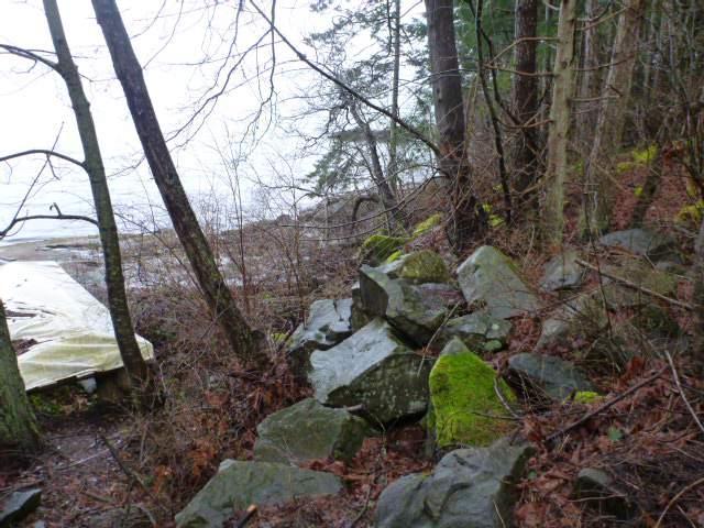
7 Access Number A-01 BEACH ACCESS INVENTORY 2014 Electoral Area A Arterial Roads Location Parking Type, Capacity and Condition Directional Aspect Adjacent Properties Development Status Present Usage or Activities at Site Footpath Hazards Description Development Options Roberts Road (bordered by CVRD to south) Latitude: N Longitude: W Limited parking available at end of ROW. Gravel, some fill required. Shared driveway access with residence to the north. West to East Residential Not Developed Some beach hiking Minor path Steep slopes, slippery rocks Foliage to water, hill sloped but accessible. Exposed sandstone bedrock features (similar appearance to Roberts Memorial Park). Steep to beach, but stairs possible on north side
8 This page is intentionally left blank.
9 Photos


10
11
12 This page is intentionally left blank.
13 Access Number A-02 BEACH ACCESS INVENTORY 2014 Electoral Area A Arterial Roads Location Parking Type, Capacity and Condition Directional Aspect Adjacent Properties Development Status Present Usage or Activities at Site Footpath Hazards Description Development Options Tumnas Way (at the end of Hertel Road/Roberts Road) Latitude: N Longitude: W Limited parking available at end of ROW. Limited room for turnaround. Shared driveway access with residence to the south. Potential for parking conflict with owners. West to East Residential Not Developed Unknown No Steep from south to north. Boggy approach. Heavy foliage. Creek runs length of narrow ROW. Small rocky bay. Potential access at end of ROW. Some stairs and boardwalk required.
14 This page is intentionally left blank.


15 Photos

16
17 This page is intentionally left blank.
18 Access Number A-03 BEACH ACCESS INVENTORY 2014 Electoral Area A Arterial Roads Location Parking Type, Capacity and Condition Directional Aspect Adjacent Properties Development Status Present Usage or Activities at Site Footpath Hazards Description Development Options Yellowpoint Road (near Roberts Memorial Park) Latitude: N Longitude: W Roadside parking. Some potential for expansion onto grassed area of ROW. West to East Residential and agricultural Not Developed Unknown No Some boggy areas Narrow (227 long, 33 wide) ROW covering multiple areas (some treed, cleared, driveway, etc.) Beach access is sandstone boulders in unique rock formations. Currently accessed through private driveway. Pins marked. Good access at end of ROW. Confusion of lot lines, survey required? Potential to create circular route with Roberts Memorial Park to the south.
19 This page is intentionally left blank.


20 Photos


21


22
23

24
25 This page is intentionally left blank.
26 Access Number A-04 BEACH ACCESS INVENTORY 2014 Electoral Area A Arterial Roads Location Parking Type, Capacity and Condition Directional Aspect Adjacent Properties Development Status Present Usage or Activities at Site Footpath Hazards Description Development Options Twin Oaks Drive (from Juriet Road) Latitude: N Longitude: W Approx. 2+ spaces available on paved ROW. West to East Residential Not Developed Recreational Yes Steeper boulders make beach access more difficult. Small creek. Short ROW with roughed in pathway. Already basic path development. More awareness required? Move concrete beach access sign to correct location.
27 This page is intentionally left blank.


28 Photos
29
30 Access Number A-05 BEACH ACCESS INVENTORY 2014 Electoral Area A Arterial Roads Location Parking Type, Capacity and Condition Directional Aspect Adjacent Properties Development Status Present Usage or Activities at Site Footpath Hazards Description Development Options Pylades Drive (south end) Latitude: Longitude: No parking available, multiple driveway accesses West to East Residential Not Developed None. No. Difficult beach access. Dense vegetation, no clear sign of access opportunity. Steep, slippery rock. Limited due to dense vegetation and access.
31 This page is intentionally left blank.


32 Photos
33
34 Access Number A-06 BEACH ACCESS INVENTORY 2014 Electoral Area A Arterial Roads Location Parking Type, Capacity and Condition Directional Aspect Adjacent Properties Development Status Present Usage or Activities at Site Footpath Pylades Drive Latitude: Longitude: On shoulder of road, multiple cars. West to East Residential Developed Recreational Yes Hazards Description Development Options Pathway and staircase to the beach. Newer porta-potty at road access. Pebbly beach. Well developed beach access. More awareness required signage?
35 This page is intentionally left blank.


36 Photos


37
38
39 This page is intentionally left blank.
40 Access Number A-07 BEACH ACCESS INVENTORY 2014 Electoral Area A Arterial Roads Location Parking Type, Capacity and Condition Directional Aspect Adjacent Properties DeCourcy Drive Latitude: Longitude: Minimal area on shoulder of road (1-2 spaces?) Paved road. South to North Residential Development Status Partially developed by resident to the east (#3452) Present Usage or Activities at Site Footpath Hazards Description Development Options Recreational No None. Grassed area with staircase developed to the beach. Small pebbled cove at beach access. 10 ft lane. Well developed beach access by residents. Further development/use might impact negatively on neighbours.
41 This page is intentionally left blank.


42 Photos
43
44 Access Number A-08 BEACH ACCESS INVENTORY 2014 Electoral Area A Arterial Roads Off Pylades Drive, South part of Ingram Road Location Latitude: Longitude: Parking Type, Capacity and Condition Directional Aspect Adjacent Properties Development Status Present Usage or Activities at Site Footpath Hazards Description Development Options Some parking on shoulder. Paved area shared driveway with access to the property to the south. West to East Residential Undeveloped None. No Steep drop to beach. Paved shared entrance off Pylades. Fenced at top, vertical drop to ocean. Limited.
45 This page is intentionally left blank.


46 Photos
47
48 Access Number A-09 BEACH ACCESS INVENTORY 2014 Electoral Area A Arterial Roads Location Parking Type, Capacity and Condition Directional Aspect Adjacent Properties Development Status Present Usage or Activities at Site Footpath Hazards Description Development Options Pylades Drive Latitude: Longitude: Limited parking on shoulder. Paved access with # shared driveway crosses right of way. West to East Residential Undeveloped Driveway No Steep drop to beach. Paved shared entrance off Pylades. History of site includes structure that burned down. Driveway slope to site, plus rocky drop off to the beach. Land owner to south using as garden plot. No beach, bare sandstone. Limited.
49 This page is intentionally left blank.


50 Photos
51

52
53 This page is intentionally left blank.
54 Access Number A-10 BEACH ACCESS INVENTORY 2014 Electoral Area A Arterial Roads Location Parking Type, Capacity and Condition Directional Aspect Adjacent Properties Development Status Present Usage or Activities at Site Footpath Hazards Description Development Options Slocum Road (off Pylades Drive) Latitude: N Longitude: W Limited parking on shoulder. West to East Residential Undeveloped Recreational. Yes Steep drop to beach past the lookout point. Viewpoint access to ocean. Bench located at lookout point (Memorial bench to Wolf Hertel). Both neighbours are encroaching on beach. Unique sandstone at low tide, good beach. Developed nicely. Could develop walkway onto beach. Signage?
55 This page is intentionally left blank.


56 Photos

57
58 Access Number A-11 BEACH ACCESS INVENTORY 2014 Electoral Area A Arterial Roads Location Parking Type, Capacity and Condition Directional Aspect Adjacent Properties Development Status Present Usage or Activities at Site Footpath Hazards Description Development Options Pylades Drive Latitude: Longitude: Limited parking on shoulder. West to East Residential Undeveloped None. No. Access is difficult. Difficult access to the water, but beach is good. Full width road allowance. Good beach, better access necessary.
59 This page is intentionally left blank.

60 Photos
61 This page is intentionally left blank.
62 Access Number A-12 BEACH ACCESS INVENTORY 2014 Electoral Area A Arterial Roads Location Parking Type, Capacity and Condition Directional Aspect Adjacent Properties Development Status Present Usage or Activities at Site Footpath Pylades Drive Latitude: N Longitude: W Limited parking on shoulder. West to East Residential Undeveloped None. No. Hazards Description Development Options Timbered near road, potential beach access. Good bay, trail potential. Clearance of vegetation to open access.
63 This page is intentionally left blank.


64 Photos
65
66 Access Number A-13 BEACH ACCESS INVENTORY 2014 Electoral Area A Arterial Roads Location Parking Type, Capacity and Condition Directional Aspect Adjacent Properties Development Status Present Usage or Activities at Site Footpath Pylades Drive (north end) Latitude: N Longitude: W Limited parking on shoulder. West to East Residential Undeveloped None. No. Hazards Description Development Options Vegetation near road, potential beach access. Long road, unclear access. Swampy sections. Clearance of vegetation to open access.
67 This page is intentionally left blank.


68 Photos
69
70 Access Number A-14 BEACH ACCESS INVENTORY 2014 Electoral Area A Arterial Roads Location Parking Type, Capacity and Condition Directional Aspect Adjacent Properties Development Status Present Usage or Activities at Site Footpath Kendall Rd Latitude: Longitude: Very limited parking on shoulder sharp hilly bend in the road South to North Residential Undeveloped None. No. Hazards Description Development Options Grassy/meadow area with large mature trees. Steeper hill with drop at water. Some stairs required.
71 This page is intentionally left blank.


72 Photos


73
74
75 This page is intentionally left blank.
76 Access Number A-15 BEACH ACCESS INVENTORY 2014 Electoral Area A Arterial Roads Location Parking Type, Capacity and Condition Directional Aspect Adjacent Properties Development Status Present Usage or Activities at Site Footpath Swan Road Latitude: Longitude: Limited parking. Private access? South to North Residential Undeveloped Some recreational use (discouraged by neighbours) No. Hazards Description Development Options Easy access to water. Difficult to determine exact location, but recent surveying completed. Views to the historic coal infrastructure of boat harbour. Confirm location.
77 This page is intentionally left blank.


78 Photos
79
80 Access Number A-16 BEACH ACCESS INVENTORY 2014 Electoral Area A Arterial Roads Location Parking Type, Capacity and Condition Directional Aspect Adjacent Properties Development Status Present Usage or Activities at Site Footpath Paul s Road (Holden Corso/Pace Road) Latitude: Longitude: Limited parking on shoulder. Northwest to southeast Residential Undeveloped None. No. Hazards Description Development Options Long access with brush and moss in places. Very good beach with coal slag visible. Clear brush near road, create mini footpath. Good option. Photos
81 This page is intentionally left blank.


82

83
84 Access Number A-17 BEACH ACCESS INVENTORY 2014 Electoral Area A Arterial Roads Location Parking Type, Capacity and Condition Directional Aspect Adjacent Properties Development Status Present Usage or Activities at Site Footpath Hazards Description Development Options Farnsworth Way (Pace Road) Latitude: Longitude: Limited parking on shared driveway/farnsworth Rd. West to East Residential Undeveloped None. No. Steeper route from road. Scenic location with barn (old Pace barn), steeper access to a nice beach. Potential conflict with owner on private drive.
85 This page is intentionally left blank.

86 Photos
87

88
89 This page is intentionally left blank.
90 Access Number A-18 BEACH ACCESS INVENTORY 2014 Electoral Area A Arterial Roads Location Parking Type, Capacity and Condition Directional Aspect Adjacent Properties Development Status Present Usage or Activities at Site Pace Road / Headland Road Latitude: Longitude: Some parking available West to East Residential to north, aquatic/agricultural to south Undeveloped Some recreational (hiking/horseriding) Footpath Informal footpath as of Summer Hazards Description Development Options Flat, easy access to beach. Mostly exposed sandstone with unique formations. Confirm location. Good development opportunity. Potential for small bridge near trailhead. Photos
91 This page is intentionally left blank.


92

93


94
95
96 Access Number A-19 BEACH ACCESS INVENTORY 2014 Electoral Area A Arterial Roads Location Parking Type, Capacity and Condition Directional Aspect Adjacent Properties Development Status Present Usage or Activities at Site Footpath Hazards Description Development Options Shasta Road Latitude: Longitude: Very narrow parking along road. West to East Residential Undeveloped None. No. Heavy forest growth Beach nice but muddy. Access through forested area. Very long narrow parcel. In spring there are beautiful wildflowers white fawn lillies and shooting stars (Erythronium Oregonum and Dodecatheon Hendersonii) Confirm location.
97 This page is intentionally left blank.


98 Photos
99
100 Access Number A-20 BEACH ACCESS INVENTORY 2014 Electoral Area A Arterial Roads Location Parking Type, Capacity and Condition Directional Aspect Adjacent Properties Development Status Present Usage or Activities at Site Footpath Hazards Description Development Options Driftwood Road (at Bostrom Road) Latitude: Longitude: Limited parking on shoulder West to East Residential Undeveloped Recreational Yes Dense forest, stream at road front. Pathway through forest, easy ocean access Small bridge/culvert needed, along with some brush cleared at the front? Very good development potential.
101 This page is intentionally left blank.


102 Photos


103
104
105 This page is intentionally left blank.
106 Access Number A-21 BEACH ACCESS INVENTORY 2014 Electoral Area A Arterial Roads Location Parking Type, Capacity and Condition Directional Aspect Adjacent Properties Development Status Present Usage or Activities at Site Footpath Lofthouse Road Latitude: Longitude: Access through driveway (no parking) West to East Residential Developed Agricultural No. Hazards Description Development Options Currently used as part of next door Standardbred Horse farm. Half size road access. No access through fences, some infrastructure (small water tank, storage) on the ROW. Beach access is steep. Potential conflict with owners.
107 This page is intentionally left blank.


108 Photos
109
110 Access Number A-22 BEACH ACCESS INVENTORY 2014 Electoral Area A Arterial Roads Location Parking Type, Capacity and Condition Directional Aspect Adjacent Properties Development Status Present Usage or Activities at Site Footpath Hazards Description Development Options Haro Road Latitude: Longitude: Gravel/asphalt parking area shared with driveway access. West to East Residential Undeveloped Recreational (but requires trespassing onto private property) No. Shell midden, cliff to water Next door to great water access alongside small stream. ROW difficult access. 33 ft. wide. Limited unless something worked out with neighbour.
111 This page is intentionally left blank.


112 Photos
113
114 Access Number A-23 BEACH ACCESS INVENTORY 2014 Electoral Area A Arterial Roads Location Parking Type, Capacity and Condition Directional Aspect Adjacent Properties Development Status Present Usage or Activities at Site Footpath Hazards Description Development Options Fawcett Road Latitude: Longitude: Limited parking on shoulder West to East Residential Undeveloped None. No. Cliff to water Narrow land with dense brush, ends in vertical drop. Limited.
115 This page is intentionally left blank.
116 Photos
117 This page is intentionally left blank.
118 Access Number A-24 BEACH ACCESS INVENTORY 2014 Electoral Area A Arterial Roads Location Parking Type, Capacity and Condition Directional Aspect Adjacent Properties Development Status Present Usage or Activities at Site Footpath Nelson Road (Boat Ramp) Latitude: Longitude: Some parking available in angle lot. Turning circle. Highly congested during summer and holidays. West to East Residential Developed. Recreational. Yes Hazards Description Development Options Developed boat ramp with stairs to beach access in north, concrete ramp to beach in south. Large beach. Developed. Further access by continuing access from another ROW location?
119 This page is intentionally left blank.


120 Photos

121

122
123 This page is intentionally left blank.
124 Access Number A-25 BEACH ACCESS INVENTORY 2014 Electoral Area A Arterial Roads Location Parking Type, Capacity and Condition Directional Aspect Adjacent Properties Development Status Present Usage or Activities at Site Footpath Hazards Description Development Options Barnes Road Latitude: Longitude: 2-3 roadside spaces. West to East Residential Undeveloped Recreational. Yes Steep descent to beach Well used beach access. Rope system to help beach access. Could better connect nearby beach access sites. (Nelson Rd Boat Ramp?) Potential to add a bench.
125 This page is intentionally left blank.

126 Photos
127
128 Access Number A-26 BEACH ACCESS INVENTORY 2014 Electoral Area A Arterial Roads Location Parking Type, Capacity and Condition Directional Aspect Adjacent Properties Development Status Present Usage or Activities at Site Footpath Hazards Description Development Options Seaspray Boulevard Latitude: Longitude: Limited parking on shoulder West to East Residential Undeveloped None. No. Vertical drop to ocean. Small site with fill, blackberry bushes and steep drop. Potential for viewing bench. Limited access.
129 This page is intentionally left blank.


130 Photos
131
132 Access Number A-27 BEACH ACCESS INVENTORY 2014 Electoral Area A Arterial Roads Location Parking Type, Capacity and Condition Directional Aspect Adjacent Properties Development Status Present Usage or Activities at Site Footpath Hazards Description Development Options Leask Road/Leeson Lane Latitude: Longitude: Limited parking on shoulder, plus paved driveway access West to East Residential Top of parcel is developed as driveway Driveway (upper area only) No. Vertical drop to ocean. Shared access Limited, but possible stairway on RofW
133 This page is intentionally left blank.


134 Photos
135
136 Access Number A-28 BEACH ACCESS INVENTORY 2014 Electoral Area A Arterial Roads Location Parking Type, Capacity and Condition Directional Aspect Adjacent Properties Development Status Present Usage or Activities at Site Footpath Hazards Description Development Options Leask Road Latitude: Longitude: Limited parking on shoulder, plus paved driveway access West to East Residential Developed as driveway/lawn for residence to the south Driveway/lawn No. Vertical drop to ocean. Shared access, flat area at top with flat open area. Limited, but possible stairway on RofW. Potential conflict with neighbours.
137 This page is intentionally left blank.


138 Photos
Currie Rd to Davidson Park
 Currie Rd to Davidson Park 3 hrs 7.2 km One way Moderate track 28m Starting at Currie Rd in Forestville, this walk follows Middle Harbour to Davidson Park, under Roseville Bridge. There are two optional
Falls Lake Trail (A part of the NC Mountains-to-Sea Trail) East to West
 East to West") Falls Lake Trail (A part of the NC Mountains-to-Sea Trail) East to West Section 1 (Falls of the Neuse Rd to Raven Ridge Rd) 0.0 mi Parking area of the Tailrace Fishing Area, just below the dam, off Falls
Falls Lake Trail (A part of the NC Mountains-to-Sea Trail) East to West Section 1 (Falls of the Neuse Rd to Raven Ridge Rd) 0.0 mi Parking area of the Tailrace Fishing Area, just below the dam, off Falls
Hunters Hill to Epping Road
 Hunters Hill to Epping Road 2 hrs 30 mins 5.5 km One way Moderate track 154m An enjoyable walk through lower sections of the Lane Cove National Park, this walk features plenty of mangroves next to the
Public Access Quarterly Report
 7/7/2017 Public Access Quarterly Report Clean Ocean Access update of 50 CRMC rights-of-way on Aquidneck Island. Contributing Authors: Eva Touhey, Program Manager, Clean Ocean Access Megan Carvalho, Communications
The Foreshore Walk. 24m. 1m Lake Macquarie LGA. 1 hr 15 mins 2.9 km One way. Hard track 81m
 The Foreshore Walk 1 hr 15 mins 2.9 km One way Hard track 81m This walk traverses the coastline of the Green Point reserve. By following a variety of tracks and occasionally traveling inland through eucalyptus
2.0 Existing Conditions
 20 2.0 Existing Conditions 2.1 Land Use, Future Growth Patterns, Physical Barriers Geographic Overview Sutter County s land use pattern is characterized by extensive agricultural areas, significant natural
Wallarah Coastal Walk
 Wallarah Coastal Walk 3 hrs 8.3 km Return Hard track 247m This walk starts at Caves Beach and travels south along the coastline, until reaching the Pinney s Headland Lookout. There are many opportunities
Directions for Day 1: Colwood To Metchosin
 Colwood-Metchosin Page 1 of 8 Directions for Day 1: Colwood To Metchosin Start: Royal Roads University, Birds of a Feather B&B, or at Esquimalt Lagoon Finish: Your accommodation in Metchosin Time: 4-5
Red Rocks Pari-whero. Red Rocks/Pari-Whero. Quarry. Owhiro Bay Quarry. Owhiro Bay Parade. Taputeranga Marine Reserve ISSUES AND OPPORTUNITIES ANALYSIS
 Red Rocks Pari-whero Wild coastal environment Shared path with WD vehicles Red Rocks/Pari-Whero Owhiro Bay Parade Owhiro Bay Quarry Quarry Taputeranga Marine Reserve 2 PART Potential future links Makara
Green Point Circuit Walk
 Green Point Circuit Walk 3 hrs 7.7 km Circuit Hard track 269m This walk visits all of the popular locations in Green Point Reserve, as well as some of the lesser-visited areas inland. Taking in Sea Eagle
Morgans Creek to Padstow
 Morgans Creek to Padstow 2 hrs 45 mins 8 km One way Moderate track 3 144m This pleasant walk starts from the Morgans Creek park, at Henry Lawsons Drive, and follows the Georges River past the Boomerang
Campbell Drive to Snapper Point
 Campbell Drive to Snapper Point 1 hr 45 mins 4.2 km One way Experienced only 135m This walk follows the Coast Track to Frazer Beach, along the Geebung and (overgrown) Grass Tree Tracks. From the northern
Falls Lake Trail (A part of the NC Mountains-to-Sea Trail) East to West
 East to West") Falls Lake Trail (A part of the NC Mountains-to-Sea Trail) East to West Section 1 (Falls of the Neuse Rd to Raven Ridge Rd) 0.0 mi Parking area of the Tailrace Fishing Area, just below the dam, off Falls
Falls Lake Trail (A part of the NC Mountains-to-Sea Trail) East to West Section 1 (Falls of the Neuse Rd to Raven Ridge Rd) 0.0 mi Parking area of the Tailrace Fishing Area, just below the dam, off Falls
Echo Point to Leura Forest via Three Sisters and Giant Stairs loop
 Echo Point to Leura Forest via Three Sisters and Giant Stairs loop 3 hrs 3.8 km Circuit Hard track 512m This walk starts from the popular Echo Point, in Katoomba, and winds down to the base of the Three
Review of Guidelines for Cycleway Safety Fencing
 Review of Guidelines for Cycleway 1.0 PURPOSE 1.1 This document is meant to provide a review of available reference documents for determining appropriate fencing requirements for cycleway paths and shared
Middle Harbour Creek Loop
 Middle Harbour Creek Loop 5 hrs 45 mins 15.1 km Circuit Experienced only 5 570m This walk explores the upper reaches of Middle Harbour Creek, starting and ending at the great parklands at Davidson Park,
Little Digger Track to Davidson Reserve and Lyrebird Circuit
 Little Digger Track to Davidson Reserve and Lyrebird Circuit 4 hrs 3 mins 11.5 km One way Hard track 4 47m Exploring both the eastern and western sides of Middle Harbour Creek, this walk follows the Little
La Madre Wilderness Area
 La Madre Wilderness Area Rock Climbing Inventory Statistics: Area: Walls La Madre North 3 24 136 22 Kraft Mt./Gateway Canyon White Rock Springs Willow Springs East The Promised Land 18 4 3 3 12 23 11 24
SELF GUIDED TOURING ROUTE
 SELF GUIDED TOURING ROUTE Things to see and places to go on the loop from Orbost to Marlo, Cape Conran, Cabbage Tree and back to Orbost (or onwards to Cann River) V6 April 2017 This guide should be read
Berowra to Mt Kuring-gai
 Berowra to Mt Kuring-gai 4 hrs 30 mins 9.4 km One way Hard track 4 551m From the ridges above Cowan Creek, this walk takes in some great lookouts (especially around Mt Kuringgai) as well as enjoying an
Tonight is for you. Learn everything you can. Share all your ideas.
 Strathcona Neighbourhood Renewal Draft Concept Design Tonight is for you. Learn everything you can. Share all your ideas. What is Neighbourhood Renewal? Creating a design with you for your neighbourhood.
Balmoral Beach to The Spit
 Balmoral Beach to The Spit 2 hrs 30 mins.3 km One way Hard track 85m This walks follows the coast from Balmoral to the Spit and across Spit Bridge. There are some alternate tracks to consider at high-tides,
Mackerel Beach and Resolute Loop
 Mackerel Beach and Resolute Loop 3 hrs 5.4 km Circuit Hard track 384m This walk is another great walk in Ku-ring-gai Chase National Park, accessed by ferry. From the Mackerel Beach wharf, this walk uses
FOCUS AREA 1 - Alberta Avenue Pocket Park 3 (121 Ave and 92 St)
") FOCUS AREA 1 - Alberta Avenue Pocket Park 3 (121 Ave and 92 St) New benches Plant evergreen trees Widen existing sidewalk from 1.5m to 1.8m Marked crosswalk 1.8m wide sidewalk Add pedestrian oriented lights
FOCUS AREA 1 - Alberta Avenue Pocket Park 3 (121 Ave and 92 St) New benches Plant evergreen trees Widen existing sidewalk from 1.5m to 1.8m Marked crosswalk 1.8m wide sidewalk Add pedestrian oriented lights
LARIMER COUNTY: ENGINEERING DOUGLAS ROAD (CR 54)
") LARIMER COUNTY: ENGINEERING DOUGLAS ROAD (CR 54) INTRODUCTIONS * Pipeline 1041 Application Coordinator Todd Blomstrom Public Works Director Mark Peterson County Engineer Terry Gilbert Community Development
LARIMER COUNTY: ENGINEERING DOUGLAS ROAD (CR 54) INTRODUCTIONS * Pipeline 1041 Application Coordinator Todd Blomstrom Public Works Director Mark Peterson County Engineer Terry Gilbert Community Development
RLRC COMMUNITIES EAST GRAND FORKS AREA CHARACTER THE RED LAKE RIVER & THE RED RIVER OF THE NORTH CONFLUENCE EAGLE POINT BOAT LAUNCH DESIGN
 AREA CHARACTER THE RED LAKE RIVER & THE RED RIVER OF THE NORTH CONFLUENCE EAGLE POINT BOAT LAUNCH DESIGN DESIGN DETAILS 135 AREA CHARACTER East Grand Forks a city of 7,501 people is located across the
Description of Road Management Objectives, Existing Use, and Proposed Use:
 Engineering Report White River National Forest Eagle-Holy Cross Ranger District Analysis of Road # 700 Red Sandstone Road for Motorized Mixed Use Designation Page 1 of 12 Forest: White River District:
Bicycle and Pedestrian Facilities Toolbox (Excerpt from Figure 3.1)
") Appendix B Neighborhood Connections Summaries This Appendix is a supplement to the information presented in Chapter 3 Connect People. The Appendix includes a summary or profile for each of the proposed
Appendix B Neighborhood Connections Summaries This Appendix is a supplement to the information presented in Chapter 3 Connect People. The Appendix includes a summary or profile for each of the proposed
De Burghs Bridge to Fullers Bridge
 De Burghs Bridge to Fullers Bridge 2 hrs 3 mins Hard track 6 km One way 2m 4 Following the Lane Cove River, this walk mostly follows a section of the Great North Walk and is well maintained and signposted.
Welsh Newton and Woodland
 Welsh Newton and Woodland This is a 8.2km miles (approx) walk which will take about 2.5 hours at a relaxed and leisurely pace. There are a few hills but no steep inclines. Start at Llangrove bus stop and
Federal Pass Walking Track
 Federal Pass Walking Track 5 hrs Hard track 8 km One way 4 989m This classic trail follows along the base of the cliffs from Leura to the Golden Stairs, passing many of the more popular sights of the Katoomba
Parks, Open Space, Trails and Recreation Master Plan
 5.3 DEFINITIONS AND VOCABULARY In order to fully understand the range of trails that have been developed, and should be developed, throughout the community, a vocabulary needs to be established for the
Patonga to Woy Woy. 5 hrs 45 mins 15.5 km One way. Hard track. 497m
 Patonga to Woy Woy 5 hrs 45 mins 15.5 km One way Hard track 4 497m This walk explores a variety of environments from the shore line and coastal cliffs near Patonga, to the dry, rocky and open ridge line.
Hornsby Blue Gum Walk
 Hornsby Blue Gum Walk 3 hrs Hard track 6.7 km Circuit 4 374m This delightful loop is one of the prettiest and most popular walks in the Hornsby area. Going from an environment of ferns and clear bushland
ST. AGNES. you cannot put a time limit on beauty.
 ST. AGNES CIRCULAR WALKS AROUND There are many enjoyable and picturesque walks around St. Agnes most are signposted and are featured on the St. Agnes Mini-guide map. Because most of our footpaths are in
Public Access Quarterly Report
 4/1/2018 Public Access Quarterly Report Clean Ocean Access update of 50 CRMC rights-of-way on Aquidneck Island. Contributing Authors: Eva Touhey, Program Manager, Clean Ocean Access Jessica Frascotti,
Improving Thetford Cycling Provision. In and Around Thetford
 Improving Cycling Provision In and Around Thetford Presentation to Thetford Town Council July 2015 About Me Lecturer in Mathematics at the University of East Anglia Keen recreational cyclist Volunteer
Trail and Driving Directions
 Trail and Driving Directions GETTING TO THE START: FROM CADILLAC: Follow M-55 west from US131 for 20.9 miles to the corner of M-37 and M-55 FROM THE INTERSECTION OF M-55 AND M-37: Head west on M-55 2.7
Walkability Audit Scores and Comments Lacey, Tumwater, and Olympia, WA September 2012
 Walkability Audit Scores and Comments Lacey, Tumwater, and Olympia, WA September 2012 The U.S. Environmental Protection Agency (EPA) provided technical assistance to Thurston Regional Planning Commission
Epping to Eastwood Station (via Lane Cove River)
") Epping to Eastwood Station (via Lane Cove River) hrs 45 mins 10.2 km One way Moderate track 189m Epping to Eastwood, via Lane Cove River, is the longer route through the bush between the stations. This
Epping to Eastwood Station (via Lane Cove River) hrs 45 mins 10.2 km One way Moderate track 189m Epping to Eastwood, via Lane Cove River, is the longer route through the bush between the stations. This
Traffic Signs and Signals
 CHAPTER FOUR Traffic Signs and Signals Traffic signs control traffic flow, making streets and highways safer for drivers, bicyclists and pedestrians. These signs, which are posted by the Indiana Department
Wentworth Falls Conservation Hut Loop
 Wentworth Falls Conservation Hut Loop 3 hrs Hard track 6.7 km Circuit 4 341m This scenic walk from Wentworth Falls Station, winds along the Nature Trail to Conservation Hut, then drops into the magnificent
Kayak Launch Sites in the Bellingham Area
 revised: Feb. 5, 2017 Page 1 of 5 Arranged Roughly North to South NOTE: if you want to see location on a map just cut and paste the Latitude and Longitude into your browser and a map with the location
Approximate distance: 5.5 miles For this walk we ve included OS grid references should you wish to use them. Start. End
 Approximate distance: 5.5 miles For this walk we ve included OS grid references should you wish to use them. End 4 1 Start 3 2 N W E S Reproduced by permission of Ordnance Survey on behalf of HMSO. Crown
Emerson Circle Entrance
 Emerson Circle Entrance It is not clear that there is a park in this location without a sign. Access from Emerson Circle: The present sloped granite curb does not provide access immediately at the park
Swamp Road Residents Study
 Swamp Road Residents Study SRRG Meeting with PennDot and Elected Officials Newtown and Wrightstown, PA April 25, 2008 Newtown Township Section of Swamp Road Limited Public Funds No reconstruction of a
ENGINEERING AND PUBLIC WORKS. Transportation Improvements: Santa s Village Road (MR15) Public Meeting
 Public Meeting") ENGINEERING AND PUBLIC WORKS Transportation Improvements: Santa s Village Road (MR15) Public Meeting March 22, 2018 Agenda Welcome and Introductions Fred Jahn: Commissioner of Engineering and Public Works
ENGINEERING AND PUBLIC WORKS Transportation Improvements: Santa s Village Road (MR15) Public Meeting March 22, 2018 Agenda Welcome and Introductions Fred Jahn: Commissioner of Engineering and Public Works
The Basin Track and Mackerel Track
 The Basin Track and Mackerel Track 3 hrs 5.9 km Circuit Hard track 226m This walk is a great way to see some popular areas in Ku-ring-gai Chase National Park. The walk from West Head Rd travels to The
Detailed maps, and portaging and camping information follow.
 Overview of Bain route. The launch site is at Davidson Lake, just before the Manitoba/Ontario border. You can do a loop if you leave a vehicle at Tulabi Lake (at the canoe route parking lot). The road
Segment Number Quick Pathways Accessibility Tool. Name of Street: Segment Identification:
 Quick Pathways Accessibility Tool Name of Street: Segment Identification: Date of survey: / / Name of surveyor(s): About this assessment: QPAT UIC Dept. of Disability and Human Development Page 1 of 15
Lawrence Loop SWOT Analysis
 Alignment: A1 (Map Color: Red) Description: This alignment connects to the Sandra Shaw Trail on the north side of the pond and heads north through undeveloped property and then west to Michigan Street
Popes Glen, Pulpit Rock, Govetts Leap and Braeside Walk
 Popes Glen, Pulpit Rock, Govetts Leap and Braeside Walk 8 hrs Hard track 13.6 km Circuit 4 1068m This large circuit walk, from Popes Glen to Pulpit Rock, Govetts leap and along the Braeside Track, passes
REGIONAL MUNICIPALITY OF WOOD BUFFALO BIKE PARK OPEN HOUSE. RMWB BIKE PARK IBI Group NOVEMBER 7, 2013
 REGIONAL MUNICIPALITY OF WOOD BUFFALO BIKE PARK OPEN HOUSE SITE CONTEXT SITE 1 NORTH PARSONS CREEK LANDS SITE 2 SILIN FOREST ROAD SITE 3 LOWER WOLVERINE SITE 4 REAL MARTIN DRIVE PARSONS CREEK TIMBERLEA
Complete Streets. Designing Streets for Everyone. Sarnia
 Complete Streets Designing Streets for Everyone Sarnia Complete Streets ~ Sarnia ~ 2018 Introduction Our City is made up of a network of streets that we use to go for a walk, cycle to work, drive to the
Canoe Trip # Maps: 63L Amisk Lake 63M Pelican Narrows
 Canoe Trip #51 49 Southeast Arem Deschambault Lake - Pelican Narrows - Wunehikun Bay - Attitti Lake - Belcher Lake - Mukoman Lake - Ohoo Lake - Mukoman River - Sokatisewin Lake - Sandy Bay 170 Kilometers
Off-road Trails. Guidance
 Off-road Trails Off-road trails are shared use paths located on an independent alignment that provide two-way travel for people walking, bicycling, and other non-motorized users. Trails specifically along
Preliminary Engineering Study
 Preliminary Engineering Study Open House # 2 June 6, 2018 PREPARED FOR: PREPARED BY: Agenda Background and status of preliminary engineering study County Road 26 design summary County Road 63 design summary
This Chapter sets forth the minimum design, technical criteria and specifications to be used in the preparation of all roadway plans.
 4.1 GENERAL This Chapter sets forth the minimum design, technical criteria and specifications to be used in the preparation of all roadway plans. These Roadway Standards are for new construction and modification
PERFORMANCE ACTIVITY 405 LIMB MANAGEMENT
 PERFORMANCE ACTIVITY 405 LIMB MANAGEMENT 405 LIMB MANAGEMENT ACTIVITY DESCRIPTION Cut and/or remove and/or grind tree limbs from the right-of-way. TRAFFIC CONTROL Utilize intermittent mobile operations
CITY OF WEST LAKE HILLS. Forest View Neighborhood Traffic Calming Study
 CITY OF WEST LAKE HILLS 901 South Mopac Expressway Building V, Suite 220 Austin, Texas 78746 Texas P.E. Firm Registration No. F-929 Klotz Associates Final Report Submittal: March 20, 2015 Revised Final
CASTLE CREEK CORRIDOR PLANNING PUBLIC OPEN HOUSE
 CASTLE CREEK CORRIDOR PLANNING PUBLIC OPEN HOUSE Wednesday, November 15, 2017 AGENDA Project Background and Today s Goals Corridor Constraints and Conflicts Usage Information Public Process Schedule Review
Wentworth Falls Station Loop (Undercliff Walk)
") Wentworth Falls Station Loop (Undercliff Walk) 4 hrs 3 mins Hard track 8.9 km Circuit 658m 4 This walk passes some stunning waterfalls and views into the Jamison Valley, following the cliff edges around
Wentworth Falls Station Loop (Undercliff Walk) 4 hrs 3 mins Hard track 8.9 km Circuit 658m 4 This walk passes some stunning waterfalls and views into the Jamison Valley, following the cliff edges around
City of Los Angeles Department of Building & Safety Disabled Access Section Supplemental Plan Review Checklist No. 8 RECREATION FACILITIES
 AMUSEMENT RIDES, BOAT SLIPS, BOWLING LANES, COURT SPORTS, FISHING PIERS Plan Check No. 1. Amusement rides required to comply with 11B-234, Amusement Rides shall provide accessible routes in accordance
Heartwood Forest, in Sandridge, Hertfordshire, is a place where everyone can find space, peace, wildlife and miles of beautiful woodland to explore.
 Heartwood Forest Accessibility Statement September 2016 Purpose: This accessibility statement outlines the available facilities and access information for Heartwood Forest. Welcome We, the Woodland Trust,
Alberta Infrastructure HIGHWAY GEOMETRIC DESIGN GUIDE AUGUST 1999
 Alberta Infrastructure HIGHWAY GEOMETRIC DESIGN GUIDE AUGUST 1999,1'(; A ACCELERATION Data on acceleration from stop D-29 Effects of grade D-35 Intersections D-97, D-99 Lanes D-97, F-5, F-7, F-15, F-21,
Rail to River and Stringybark Creek Reserve Walk
 Rail to River and Stringybark Creek Reserve Walk 4 hrs Hard track 11.2 km Circuit 4 302m This walk begins in the busy city of Chatswood and soon enters the nearby bushland around the Lane Cove River. The
Blackheath Station to Junction Rock Loop (via Grand Canyon and Popes
 Blackheath Station to Junction Rock Loop (via Grand Canyon and Popes 8 hrs 30 mins 18.2 km Circuit Hard track 4 1254m This circuit starts in Blackheath and heads down into the Grand Canyon and Rodriguez
SECTION 3 STREET DESIGN
 3.01 GENERAL SECTION 3 STREET DESIGN For purposes of geometric and structural design, streets shall be classified according to the following table. The City Engineer will determine the class of all proposed
Start / Finish. Version 2
 Start / Finish Version 2 Gosford (Start) to Woy Woy Head South down Etna Street, crossing Henry Parry Drive, then Mann St, Gosford, where Etna St becomes Racecourse Road. Follow this road all the way
Under and Over Cliff Walk
 Under and Over Cliff Walk 4 hrs 9.4 km Circuit Moderate track 576m This walk from Wentworth Falls Station is a fantastic way to see a large majority of the Wentworth Falls cliffline. The track winds under
Wentworth Falls Loop. 893m. 665m. 6 hrs 10.2 km Circuit. Hard track 1093m. Blue Mountains National Park
 Wentworth Falls Loop 6 hrs 1.2 km Circuit Hard track 193m This is a great walk, both in size and spectacular views. The walk makes its way from Wentworth Falls train station and drops off the plateau,
APPENDIX E Needs Assessment
 APPENDIX E Needs Assessment Active Transportation Needs Assessment Technical Background This appendix provides the technical background supporting the findings presented in Section 3 of the report. Developed
DRAFT. System Components. Greenway Trails. Introduction. Trail Types. Zebulon Greenway Master Plan
 5 System Components Wakefield Street Photo Simulation showing Sharrows Introduction The Master Plan identifies various system components that, together, create a comprehensive greenway system. These components
Govetts Leap Loop. 1065m. 909m Blue Mountains National Park. 4 hrs 30 mins 8.7 km Circuit. Hard track 380m
 Govetts Leap Loop 4 hrs 30 mins 8.7 km Circuit Hard track 380m This walk, from Blackheath Train Station, is a fantastic way to see some of the iconic areas of the Blue Mountains in the Blackheath area.
Explore the outdoors in Shelby County
 Explore the outdoors in Shelby County Oak Mountain Trail GPS: 33.283831-86.865238 Trail Location: Address: Oak Mountain State Park Trail 200 Terrace Drive Pelham, AL 35124 Type of Trail: Walking, Mountain
Times. S E S/Rd(E) Wakefield Road) Wakefield Rural Fire Brigade
 Wakefield Road) Wakefield Rural Fire Brigade") START On York Street, Teralba adjacent to Tulkaba Park Sports Pavilion (on leaving travel west on York Street) [EEP-1A] Position* Altitude Distance (km)* Trail S32 57.593 E151 36.520 21 0.5 0.5 S/Rd(E)
START On York Street, Teralba adjacent to Tulkaba Park Sports Pavilion (on leaving travel west on York Street) [EEP-1A] Position* Altitude Distance (km)* Trail S32 57.593 E151 36.520 21 0.5 0.5 S/Rd(E)
EAST GRINSTEAD AND THE HIGH WEALD, WEST SUSSEX
 EAST GRINSTEAD AND THE HIGH WEALD, WEST SUSSEX 7 miles Circular 3.5 hours 301015 Challenging Terrain Hi, I'm Tom and this is my West Sussex Weekends walk. I live and work in London but often head out of
Montgomery County Life Sciences Center Loop Trail
 Montgomery County Life Sciences Center Loop Trail Advisory Committee Meeting #1 February 10, 2015 Agenda 1. Project Background 2. Existing Conditions Analysis 3. Examples from Elsewhere 4. Discussion Project
CONNECTIVITY PLAN. Adopted December 5, 2017 City of Virginia Beach
 CONNECTIVITY PLAN Adopted December 5, 2017 City of Virginia Beach CONTENTS 1.0 Background & Purpose... 2 2.0 Existing Inventory & Analysis... 3 ViBe District Existing Walking Conditions... 4 3.0 ViBe District
Carrington Park to Leura Forest and pass loop
 Carrington Park to Leura Forest and pass loop 3 hrs Hard track 4.8 km Circuit 4 674m This walk is a fantastic way to see Leura Forest. The walk descends from Carrington Park, visiting Leura Forest and
NEWLANDS CORNER AND ST MARTHAS
 NEWLANDS CORNER AND ST MARTHAS 10k CIRCULAR ROUTE 2½-3HRS GU4 8SE From Newlands Corner on the North Downs just outside Guildford, you can enjoy one of the most beautiful panoramas of quintessential English
West Dimond Blvd Upgrade Jodhpur Street to Sand Lake Road
 West Dimond Blvd Jodhpur St to Sand Lake CSS Transportation Project Summary Municipality of Anchorage Project # 05 005 Project Manager: John Smith, P.E. (MOA PM&E) Project Administrator: Julie Makela,
East Burke Transportation, Safety and Capacity Improvements
 East Burke Transportation, Safety and Capacity Improvements The purpose of this project is to increase mobility and improve safety for pedestrians, cyclists, and motor vehicles along VT Route 114 in the
5 CIRCULATION AND STREET DESIGN
 5 CIRCULATION AND STREET DESIGN This chapter describes circulation and streetscape improvements proposed for the Northwest Chico Specific Plan Area. It includes detailed design specifications for existing
Chapter 3 DESIGN SPECIFICATIONS
 Brampton PathWays Planning and Design Guidelines 27 Chapter 3 DESIGN SPECIFICATIONS 3.1 CLASS 1 MULTI-USE PATH Off-road multi-use trails are the backbone of the Brampton PathWays Network. They are typically
THE WELLDIGGERS ARMS, HESWORTH AND FITTLEWORTH TRAIL
 THE WELLDIGGERS ARMS, HESWORTH AND FITTLEWORTH TRAIL 5.5 miles Circular 3 hours 041017 Challenging Terrain A 300-year-old pub turned country-inn on the edge of the South Downs National Park, The Welldiggers
Access Management in the Vicinity of Intersections
 Access Management in the Vicinity of Intersections FHWA-SA-10-002 Technical Summary Photo: Ralph Bentley (used with permission) 0 Access Management is: The design, implementation and management of entry
HARDMOORS 26.2 WHITE HORSE HALF ROUTE DESCRIPTION - 018
 HARDMOORS 26.2 WHITE HORSE HALF ROUTE DESCRIPTION - 018 Follow Cleveland Way, keeping to the left hand path (right path is a bike trail) Ignoring any turnings to the left or right At path junction (after
9.5 km Circular 3 hours
 MEDIEVAL WAVERLEY Challenging Terrain A 6 mile (9.5km) undulating circular walk from Tilford village passing close to The Sands village and the historic ruins of Waverley Abbey. From the top of Crooksbury
01. VICINITY OF GREENBRAE POC: EXISTING CONDITIONS
 01. VICINITY OF GREENBRAE POC: EXISTING CONDITIONS Existing Bus Stop Existing US101 On-ramp Existing POC Old Redwood Highway Rich Street City ROW Environmental Study Limit Industrial Way NO DESIGNATED
BOLAND DRIVE PATH PROJECT. Martin Le Jack Reilly Paul Rodriguez Allison Rotella Maria Wilson
 BOLAND DRIVE PATH PROJECT Martin Le Jack Reilly Paul Rodriguez Allison Rotella Maria Wilson INTRODUCTION TO PROJECT The purpose: to construct a multi-purpose path, which will connect two existing bike
Walk: NOC 08 Location: Cym Glyn near Brecon
 33 Walk: NOC 08 Location: Cym Glyn near Brecon Directions: Not easy to find at all. Go to Libanus, then head towards Brecon on the A470. Take minor C road single track lane first right as you come out
The Year Of Mercy Pilgrimage Sts Peter and Paul s Church, Bulimba To The Cathedral of St Stephen
 The Year Of Mercy Pilgrimage Sts Peter and Paul s Church, Bulimba To The Cathedral of St Stephen Dist Route Photos Photos 0.0km St Peter and Paul s Church, 235 Riding Rd & Cnr Main Ave, Balmoral. http://www.bulimbacatholic.com/
Bouddi Coastal Walk. 5 hrs. Hard track 8.1 km One way. 364m
 Bouddi Coastal Walk 5 hrs Hard track 8.1 km One way 4 364m This is one of the longer walks in the Bouddi National Park and it is rich in scenery. The walk follows the coastline with many side trips to
Detailed Descriptions and Maps of Woodside s Nature Trails
 Detailed Descriptions and Maps of Woodside s Nature Trails Access Mill Road Trail Park along Anderson Mill road. Signs on West Pleasant Colony and Anderson Mill road clearly point to the beginning of the
This page intentionally left blank.
 This page intentionally left blank. COMMUNITY Coweta Community Overview Coweta Coweta, a residential community located in Wagoner County, is a suburb of Tulsa situated southeast of the metropolitan area
CONNECTING PEOPLE TO PLACES
 CONNECTING PEOPLE TO PLACES 82 EAST BENCH MASTER PLAN 07 Introduction The East Bench transportation system is a collection of slow moving, treelined residential streets and major arteries that are the
Equestrian Estate. Property Features. For Sale - $2,900, Woodbrook Way, Fountain, NC
 Property Features 230+/- acres 8 stall state of the art attached barn with 3 miles of fenced pasture land Riding / jumping arena & miles of riding trails Gated residential equestrian development with approved
TGSI Tactile Ground Surface Indicators
 TGSI Tactile Ground Surface Indicators Introduction: This Design Note, No 11, provides guidelines and requirements for the use and installation of Tactile Ground Surface Indicators (TGSI s). References
Affects of Tides on Lateral Coastal Access at. Las Varas Ranch. Gaviota, California. Photos Courtesy of California Coastal Records Project
 Affects of Tides on Lateral Coastal Access at Las Varas Ranch Gaviota, California Photos Courtesy of California Coastal Records Project September 18, 2014 Santa Barbara County Trails Council 1 As part