REGIONAL MUNICIPALITY OF WOOD BUFFALO BIKE PARK OPEN HOUSE. RMWB BIKE PARK IBI Group NOVEMBER 7, 2013
|
|
|
- Myles McCormick
- 5 years ago
- Views:
Transcription

1 REGIONAL MUNICIPALITY OF WOOD BUFFALO BIKE PARK OPEN HOUSE

2 SITE CONTEXT SITE 1 NORTH PARSONS CREEK LANDS SITE 2 SILIN FOREST ROAD SITE 3 LOWER WOLVERINE SITE 4 REAL MARTIN DRIVE PARSONS CREEK TIMBERLEA DICKINSFIELD BIRCHWOOD TRAILS THICKWOOD HEIGHTS WOOD BUFFALO N
3 SITE MATRIX SITE NUMBER SIZE (ha) OWNERSHIP POTENTIAL CYCLING COMPONENTS EXISTING CONDITIONS SLOPE ANALYSIS INFRA- STRUCTURE / SERVICING ROAD ACCESS TRAIL BUILDING AND MAINTENANCE DISTANCE TO TRANSIT REGULARITY OF TRANSIT CURRENT ZONING OR LAND USE POTENTIAL LINKS TO TRAILS AND PARKS NORTH PARSONS CREEK LANDS RMWB (FUTURE MR) ALL MOSTLY CLEARED SOME TREES REMAINING SWMF ON SITE MEDIUM ALL REQUIRED CONFEDERATION BLVD REQUIRED WITH MODERATE SITE ACCESS FUTURE FUTURE URBAN EXPANSION CONNECTIONS TO EXISTING TRAILS AND POSSIBLE FUTURE PARK AND TRAIL LINKS SILIN FOREST ROAD RMWB ALL NATIVE TREE AND VEGETATION SOME CLEARED AREAS PREDOMINANTLY STEEP WITH SOME FLAT AREAS SOME EXISTING PARKING OTHER SERVICING IS REQUIRED THICKWOOD BOULEVARD ROSS HAVEN DR. ROMANY ST. THICKET DRIVE REQUIRED WITH EASY SITE ACCESS CLOSE FREQUENT DIRECT CONTROL EXISTING TRAIL LINKS AND POTENTIAL FOR FUTURE PARK AND TRAIL LINKS LOWER WOLVERINE RMWB MB TRAILS ONLY DUE TO LINEAR NATURE OF THE SITE NATIVE TREE AND VEGETATION MULTI-USE TRAIL VARIES ALL REQUIRED THICKWOOD BOULEVARD SIGNAL RD REQUIRED WITH EASY SITE ACCESS CLOSE FREQUENT PARKS AND RECREATION POTENTIAL FOR FUTURE PARK AND TRAIL LINKS REAL MARTIN DRIVE CROWN LAND ALL NATIVE TREE AND VEGETATION WITH EXISTING TRAILS SOME SWAMP/BOG MIX OF SLOPES ALL REQUIRED THICKWOOD BOULEVARD REAL MARTIN DR. REQUIRED WITH MODERATE SITE ACCESS CLOSE FREQUENT ENVIRONMENTAL PRESERVATION POTENTIAL FOR FUTURE PARK AND TRAIL LINKS ACCEPTABLE SOME CONFLICT BUT REASONABLY ACCEPTABLE UNACCEPTABLE


4 SITE 1 NORTH PARSONS CREEK LANDS 18.6 HA. OF LAND FOR FUTURE MUNICIPAL RESERVE SITE SUPPORTS ALL CYCLING COMPONENTS WILL REQUIRE TRAIL BUILDING AND APPROPRIATE STEWARDSHIP ON COMPLETION OF TRAIL BUILDING PARSONS CREEK EXISTING SITE IS COMPRISED OF MOSTLY CLEARED LAND WITH SOME EXISTING TREE COVER AND OFFERS SOME TOPOGRAPHICAL VARIATION SITE HAS NO EXISTING INFRASTRUCTURE /SERVICING AND ACCESS COULD BE FROM CONFEDERATION BLVD. CURRENTLY THERE IS NO TRANSIT ACCESS TO THE SITE BUT FUTURE PARSONS CREEK TRANSIT ROUTES ARE PLANNED THE LAND IS CURRENTLY ZONED FOR URBAN EXPANSION AND PROVIDES CONNECTIONS TO EXISTING TRAILS AND POSSIBLE FUTURE TRAIL LINKS N


5 SITE 2 SILIN FOREST ROAD 38.0 HA. OF RMWB OWNED LAND SITE SUPPORTS ALL CYCLING COMPONENTS WILL REQUIRE TRAIL BUILDING AND APPROPRIATE STEWARDSHIP ON COMPLETION OF TRAIL BUILDING THICKWOOD HEIGHTS SITE IS COMPRISED MOSTLY OF NATIVE TREE COVER AND VEGETATION WITH SOME CLEARED AREAS AND HAS VARIED SLOPES WITH SOME FLAT AREAS ROSS HENNIGAR PARK WATER TREATMENT PLANT SITE HAS A BASEBALL DIAMOND ADJACENT TO IT WITH EXISTING PARKING AREA BUT WILL REQUIRE ALL OTHER INFRASTRUCTURE /SERVICING ACCESSED FROM THICKWOOD BLVD, ROSS HAVEN DR, ROMANY ST, AND THICKET DR CLOSE TO TRANSIT ROUTES THAT RUN THICKWOOD HEIGHTS FREQUENTLY ROSS HENNIGAR PARK THE LAND IS CURRENTLY ZONED FOR DIRECT CONTROL AND PROVIDES CONNECTIONS TO EXISTING TRAILS AND POTENTIAL FOR FUTURE TRAIL LINKS WATER TREATMENT PLANT N


6 SITE 3 LOWER WOLVERINE 18.8 HA. OF RMWB OWNED LAND DUE TO THE LINEAR NATURE OF THE SITE IT WOULD ONLY SUPPORT THE MOUNTAIN BIKE TRAILS CYCLING COMPONENT WILL REQUIRE TRAIL BUILDING AND APPROPRIATE STEWARDSHIP ON COMPLETION OF TRAIL BUILDING SITE IS COMPRISED MOSTLY OF NATIVE TREE COVER AND VEGETATION WITH A MULTI-USE TRAIL ALONG SIGNAL ROAD ST. GABRIEL SCHOOL THICKWOOD HEIGHTS ACCESS WOULD BE FROM THICKWOOD BLVD AND SIGNAL RD FT. MCMURRAY GOLF CLUB CLOSE TO TRANSIT ROUTES THAT RUN FREQUENTLY WESTWOOD SCHOOL & YMCA ST. GABRIEL SCHOOL THICKWOOD HEIGHTS THE LAND IS CURRENTLY ZONED FOR PARKS AND RECREATION, HAS EXISTING TRAILS AND PROVIDES POTENTIAL FOR FUTURE LINKS FT. MCMURRAY GOLF CLUB N


7 SITE 4 REAL MARTIN DRIVE 28.9 HA. OF CROWN LAND WOOD BUFFALO SITE SUPPORTS ALL CYCLING COMPONENTS WILL REQUIRE TRAIL BUILDING AND APPROPRIATE STEWARDSHIP ON COMPLETION OF TRAIL BUILDING SITE IS COMPRISED MOSTLY OF NATIVE TREE COVER AND VEGETATION WITH SIGNIFICANT AREAS OF SWAMP/ BOG AREA AND OFFERS A MIX OF SLOPES SITE HAS NO EXISTING WOOD BUFFALO INFRASTRUCTURE / SERVICING AND WOULD BE ACCESSED FROM THICKWOOD BLVD AND REAL MARTIN DR CLOSE TO TRANSIT ROUTES THAT RUN FREQUENTLY THE LAND IS CURRENTLY ZONED FOR ENVIRONMENTAL PRESERVATION AND PROVIDES POTENTIAL FOR FUTURE TRAIL LINKS N
 LOOP TRAILS BRIDGES JUMPS LOG RIDES LOG JUMPS WALL RIDE SLOPE")

 CYCLOCROSS GRASS TRACK SANDPIT HILL CLIMB STAIRCASE RUN-UPS")


8 BIKE PARK COMPONENTS MOUNTAIN BIKE NETWORK OF SINGLE TRACK (WIDER IN SPOTS FOR PASSING) LOOP TRAILS BRIDGES JUMPS LOG RIDES LOG JUMPS WALL RIDE SLOPE STYLE CROSS COUNTRY GRAVITY DUAL SLALOM 24 HOUR BMX COURSE FENCED, COMPETITIVE PAVED START DECK FREESTYLE SECTION PUMP TRACK DIRT JUMPS SPEED ROLLERS RHYTHM SECTION TUNNEL (10 DIA. PRE-CAST CONC. SECTION) CYCLOCROSS GRASS TRACK SANDPIT HILL CLIMB STAIRCASE RUN-UPS FLY-OVER TRIALS AREA SET UP TRIALS AREA ACCORDING TO UCI STANDARDS TO ALLOW FOR JUDGED EVENTS THAT WOULD INCLUDE: BACKHOP BUNNY HOP PEDAL HOP SIDE HOP DROP OFF ROAD CYCLISTS ROAD TRACK LOOPING FROM PARK ENTRANCE PAVED SINGLE LANE SEPARATE FROM OTHER TRAILS ACCESS FOR MAINTENANCE AND EMERGENCY CHILDREN/BEGINNERS LEARNING LOOP
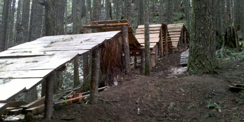

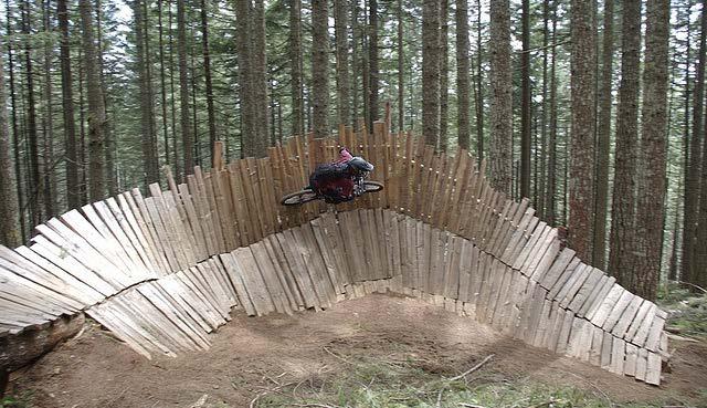
9 PARK COMPONENTS MOUNTAIN BIKE
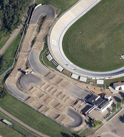

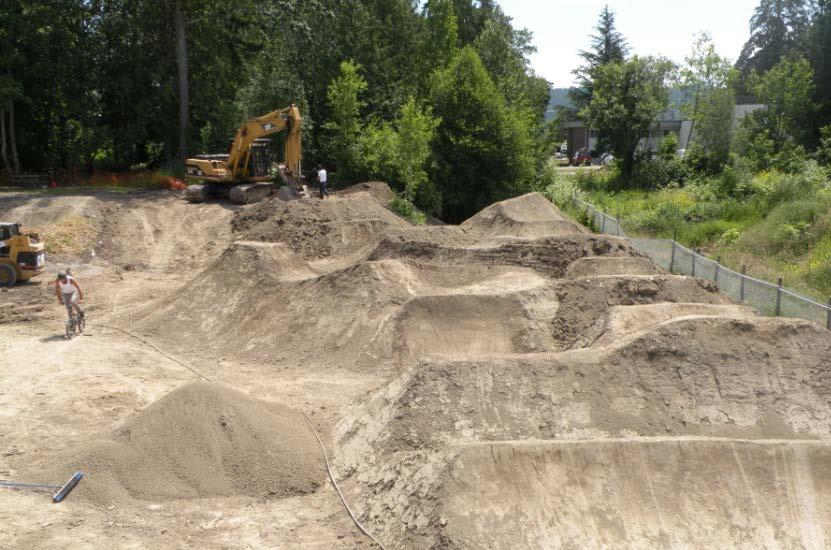
10 PARK COMPONENTS BMX
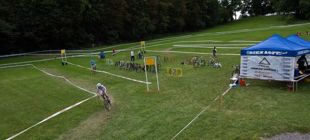

11 PARK COMPONENTS CYCLOCROSS
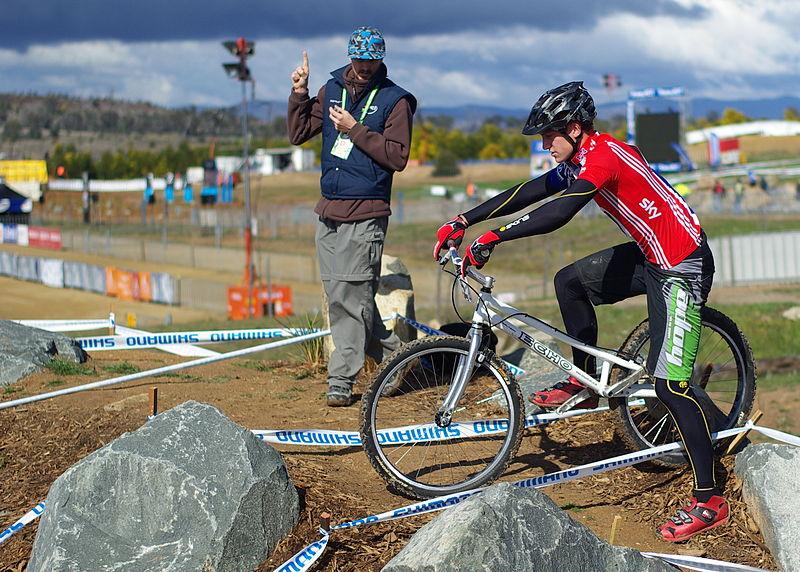

12 PARK COMPONENTS TRIALS
13 POSSIBLE NON-BIKE PARK COMPONENTS PARKING WASHROOMS FUTURE DEVELOPMENT EMERGENCY ACCESS PODIUM / STAGING AREA, START AND FINISH SIGNAGE REGULATORY ENTRY WAY-FINDING / INTERPRETIVE PUBLIC BIKE REPAIR STATIONS SIMPLE - BOLLARD MOUNTED CLAMP MANUFACTURED DERO, FIXTATION EVENT PLAZA CLUBHOUSE CHANGE ROOMS REPAIR SHOP SEMINAR/MEETING/CLASSROOM/SOCIAL AREA PLAYGROUND BLEACHERS / SPECTATORS AREA HAND PUMPS AIR PUMP W/GENERATOR TOOLS ON CABLES BIKE WASH STATION CHAIN CLEANING STATION
 EVENT PLAZA (FUTURE DEVELOPMENT) BLEACHERS (FUTURE")
14 CONCEPTUAL BUBBLE DIAGRAM CLUBHOUSE (FUTURE DEVELOPMENT) PLAYGROUND (FUTURE DEVELOPMENT) EVENT PLAZA (FUTURE DEVELOPMENT) BLEACHERS (FUTURE DEVELOPMENT)
15 FUNDING SOURCES FUTURE MUNICIPAL BUDGET CORPORATE SPONSORSHIP GOVERNMENT GRANTS
16 WE NEED YOUR FEEDBACK AND COMMENTS THANK YOU FOR JOINING US
Ft. Tuthill Bike Park. design proposal
 Ft. Tuthill Bike Park design proposal What is this? A bicycle skills park is specially designed to provide riders a place to practice skills, learn to jump, have fun on mountain bikes, and watch and encourage
Part B Design Guidance / Principles _
 Part B Design Guidance / Principles www. landlab.co.nz Queenstown Town Centre Public Realm Design Guidelines Version 7 14 June 2018 Page 006 B1 Design Guidance & Best Practice The Queenstown Town Centre
Montgomery County Life Sciences Center Loop Trail
 Montgomery County Life Sciences Center Loop Trail Advisory Committee Meeting #1 February 10, 2015 Agenda 1. Project Background 2. Existing Conditions Analysis 3. Examples from Elsewhere 4. Discussion Project
WELCOME! TOWN CENTRE PARK INFORMATION SESSION WHAT IS HAPPENING? GOALS FOR TODAY. TOWN STAY CONNECTED WITH US! #1 INFORM WE ARE HERE
 1 WELCOME! Thank you for coming to the Information Session! Please provide us with your comments and ideas. We will use your input to inform the visioning process and creation of the framework for the
RIDER PERFORMANCE PROFILE
 RIDER PERFORMANCE PROFILE NAME: DISCIPLINE: PRINCIPLE EVENT: COACH: DATE: Cycling Irel Long Term Athlete Development - Performance Profile CYCLING IRELAND RIDER PERFORMANCE PROFILE RIDER: Colour in the
Proposed Bridge Street East Bicycle Lanes Public Open House Thursday, April 27, 2017
 WELCOME Proposed Bridge Street East Bicycle Lanes Public Open House Thursday, April 27, 2017 Purpose of the Open House The purpose of this Open House is to gain public input on the bicycle lanes proposed
2011 ASLA Design Awards. Valmont Bike Park Merit Award BHA Design. Design over $500,000 Construction Budget
 2011 ASLA Design Awards Valmont Bike Park Merit Award BHA Design Design over $500,000 Construction Budget Project Fact Sheet Valmont Bike Park Boulder, Colorado Construction Budget - $4,300,000 Project
Douglas A. Ormseth Shortgrass Web Development
 Douglas A. Ormseth Shortgrass Web Development doug@shortgrass.com 406-261-1115 (Note: others have proposed some of these ideas already in the Black Eagle Community Visioning document and on the Rivers
Harcourt Mountain Bike Park Proposal Scoping Study and Reference Framework May. Appendix 1. Harcourt Mountain Bike Park Master Plan 2014.
 Harcourt Mountain Bike Park Proposal Scoping Study and Reference Framework May Appendix 1. Harcourt Mountain Bike Park Master Plan 2014. Appendix 1.0. Matrix of Comparative Mountain Bike Park Facilities
COPE PARK MASTER PLAN
 COPE PARK MASTER PLAN CBJ Parks & Recreation Department is in the process of creating a Master Plan for the Cope Park Area. New restrooms are designated to be constructed in the park in the next year.
CASTLE CREEK CORRIDOR PLANNING PUBLIC OPEN HOUSE
 CASTLE CREEK CORRIDOR PLANNING PUBLIC OPEN HOUSE Wednesday, November 15, 2017 AGENDA Project Background and Today s Goals Corridor Constraints and Conflicts Usage Information Public Process Schedule Review
Tech Guide: 25th Annual Cycle-Smart International Technical Guide Saturday, November 7th and Sunday, November 8th, 2015
 Tech Guide: 25th Annual Cycle-Smart International Technical Guide Saturday, November 7th and Sunday, November 8th, 2015 Look Park, Northampton, MA Verge New England Cyclo-cross Series presented by Stan's
Mountain Biking Comes to Town
 Mountain Biking Comes to Town Mountain Biking Old School Mountain Biking New School Agenda 1. Introductions 2. What is a bike park? 3. Who wants a bike park? 4. Why should you build it? 5. Where can you
THE FIRST MOUNTAIN BIKE TRAIL CENTRE IN THE GCC & MIDDLE EAST
 THE FIRST MOUNTAIN BIKE TRAIL CENTRE IN THE GCC & MIDDLE EAST INTRODUCTION WELCOME TO HATTA TRAIL CENTRE WEBSITE Hatta Trail Centre is a first MTB Centre in the Middle East, and is a home to multiple cross
Cottonwood Heights HAWK Pedestrian Crossing on Fort Union Blvd. Project Type Capital Improvement
 Cottonwood Heights HAWK Pedestrian Crossing on Fort Union Blvd. At West Side of Mountview Park Entrance (Approx. 1600 East) $ 206,800 $ 192,800 Install a HAWK Pedestrian Crossing System on Fort Union Boulevard,
Heartwood Forest, in Sandridge, Hertfordshire, is a place where everyone can find space, peace, wildlife and miles of beautiful woodland to explore.
 Heartwood Forest Accessibility Statement September 2016 Purpose: This accessibility statement outlines the available facilities and access information for Heartwood Forest. Welcome We, the Woodland Trust,
Methuen Rail Trail City of Methuen Public Information Meeting Methuen City Hall
 Methuen Rail Trail City of Methuen Public Information Meeting Methuen City Hall September 22, 2016 Agenda 1 Welcome and Introductions 2 Methuen Rail Trail Update 3 What is a Rail Trail? 4 Conceptual Design
FOCUS AREA 1 - Alberta Avenue Pocket Park 3 (121 Ave and 92 St)
") FOCUS AREA 1 - Alberta Avenue Pocket Park 3 (121 Ave and 92 St) New benches Plant evergreen trees Widen existing sidewalk from 1.5m to 1.8m Marked crosswalk 1.8m wide sidewalk Add pedestrian oriented lights
FOCUS AREA 1 - Alberta Avenue Pocket Park 3 (121 Ave and 92 St) New benches Plant evergreen trees Widen existing sidewalk from 1.5m to 1.8m Marked crosswalk 1.8m wide sidewalk Add pedestrian oriented lights
Bicycle and Pedestrian Facilities Toolbox (Excerpt from Figure 3.1)
") Appendix B Neighborhood Connections Summaries This Appendix is a supplement to the information presented in Chapter 3 Connect People. The Appendix includes a summary or profile for each of the proposed
Appendix B Neighborhood Connections Summaries This Appendix is a supplement to the information presented in Chapter 3 Connect People. The Appendix includes a summary or profile for each of the proposed
STAFF REPORT. Meeting Date: March 1, 2017 Agenda Item 5B
 Meeting Date: March 1, 2017 Agenda Item 5B STAFF REPORT Agency: Staff Contact: Agenda Title: Agenda Action: City of Belmont, Parks & Recreation Commission Jonathan Gervais, Parks & Recreation Director,
Downey Road. Transportation Improvement Study
 Downey Road Transportation Improvement Study Workshop 2 Participant Handbook Workshop 1 May 18 and 19, 2016 Workshop 2 June 23 and 28, 2016 Prepared By: City of Guelph Paradigm Transportation Solutions
Garden City Community Park - Bike Terrain Park Consultation Process
 City of Richmond Report to Committee To: Parks, Recreation and Cultural Services Committee Date: May 13, 2013 From: Mike Redpath, File: 06-2345-20- Senior Manager, Parks MNOR1NoI01 Re: Garden City Community
Citizen Advisory Committee Meeting. November 15, 2011 MPRB Headquarters- 6:30-8:30 p.m.
 Citizen Advisory Committee Meeting November 15, 2011 MPRB Headquarters- 6:30-8:30 p.m. Charge for Wirth Lake Area Citizen Advisory Committee: Prepare recommendations for the Board of Commissioners on the
SR-203 Sidewalks and Town-Wide Mobility Improvements. Town Council Presentation September 7, 2016
 SR-203 Sidewalks and Town-Wide Mobility Improvements Town Council Presentation September 7, 2016 SR-203 Sidewalks and Town- Wide Mobility Improvements SR-203 Sidewalks and Appurtenances Town-Wide Mobility
San Bernardino County Non-Motorized Transportation Plan - Chapter 5
 City of Upland Population 76,106 City Overview The City of Upland was incorporated on May 15, 1906, after previously being named North Ontario. The City was originally established as an irrigation colony
Caerlee: Average Age = 6 (June 2017)
") Caerlee: Average Age = 6 (June 2017) Safety Able to follow M Check Take part in 10 minute blocks of cycling or coaching. Equity/ Social Able to interact and share with peers. Plays by the rules. Confident
Caerlee: Average Age = 6 (June 2017) Safety Able to follow M Check Take part in 10 minute blocks of cycling or coaching. Equity/ Social Able to interact and share with peers. Plays by the rules. Confident
Thanks for joining us. Mark Franz Cycling Club Coordinator John Gozum Cycling Club Commissioner
 Welcome to the fourth season of the VAA s Youth Cycling Club, it promises to be a great one. We believe we have 8 unique events which will expose an array of cycling disciplines to participants and their
Active Transportation Infrastructure Investment A Business Case
 Active Transportation Infrastructure Investment A Business Case In 2016, the Real Estate Foundation awarded the Capital Regional District a $50,000 grant for Shifting Gears: Land Use Change through Active
Other Initiatives. Highest 10 Year Value Projects Capital Budget and Financing Plan
 Other Initiatives In addition to the $867 million in projects included in the other sections, staff has also identified projects which they feel are important, however, due to funding constraints have
City Snapshot September 27, 2018
 1 City Snapshot September 27, 2018 Respondent Introduction Thank you for providing data for the PlacesForBikes City Rating program! The information you provide will be used to understand the progress your
Centennial Neighbourhoods Transportation Management Plan Summary of Phase 1 Consultation. Overview of Issues
 1 Centennial Neighbourhoods Transportation Management Plan Summary of Phase 1 Consultation The Centennial Neighbourhoods Transportation Management Plan (CNTMP) is being undertaken to support the Secondary
The study area for this project is the entire County of Oxford including both the urban centres and rural areas.
 INTRODUCTION In July 2013 Oxford County initiated a study to develop a long term Trails Master Plan. The study is now being undertaken collaboratively with the County, the consultant team from MMM Group
HILLSDALE/US101 BICYCLE/PEDESTRIAN BRIDGE PROJECT
 HILLSDALE/US101 BICYCLE/PEDESTRIAN BRIDGE PROJECT PUBLIC WORKSHOP AUGUST 19, 2014 DEPARTMENT OF PUBLIC WORKS STEWARDS OF THE INFRASTRUCTURE AND ENVIRONMENT PROJECT TEAM Aaron Lam, Associate Engineer Tracy
General Design Factors
 Chapter 3: 3-1.0 Introduction General Design Factors Mn/DOT s goals include encouraging and accommodating safe bicycling. From a design perspective, these goals are achieved by first having an understanding
MAG Town of Cave Creek Bike Study Task 6 Executive Summary and Regional Significance Report
 Page 1 MAG Town of Cave Creek Bike Study Task 6 Executive Summary and Regional Significance Report August 1, 2012 MAG Project #481 Page 2 Task 6 Executive Summary and Regional Significance Report Introduction
Tonight is for you. Learn everything you can. Share all your ideas.
 Strathcona Neighbourhood Renewal Draft Concept Design Tonight is for you. Learn everything you can. Share all your ideas. What is Neighbourhood Renewal? Creating a design with you for your neighbourhood.
ACTIVE TRANSPORTATION SUMMIT. Active Transportation in Small Urban and Rural Communities Bicycles
 ACTIVE TRANSPORTATION SUMMIT Active Transportation in Small Urban and Rural Communities Bicycles Presented by: Robin McCleave, V.P. Risk Manager, Public Sector, JLT Canada 23 May 2018 When creating or
APPENDIX A: Complete Streets Checklist DRAFT NOVEMBER 2016
 APPENDIX A: Complete Streets Checklist DRAFT NOVEMBER 2016 Complete Streets Checklist MetroPlan Orlando s Complete Streets Checklist is an internal planning tool for staff to further implementation of
LIST OF POTENTIAL PROJECTS
 1 next few years Mail ClusterBox Consolidation with Overhead Roof Structure (2 stations) EV charging stations utilizing TDPUD rebates Seasonal Employee Housing Regular Daycare Skating Rink Water Bottle
ROUTE START TIME SUMMARY
 ROUTE START TIME SUMMARY EVENING 10 and 12 HOUR - SAT, SUN and STAT HOLIDAYS ROUTE SHIFT START TIME DESCRIPTION DIRECTION 12AB-9A ARR 12HR 4:45PM Abasand Fort McMurray to Horizon 12DT-9A ARR 12HR 4:45PM
Living Streets Policy
 Living Streets Policy Introduction Living streets balance the needs of motorists, bicyclists, pedestrians and transit riders in ways that promote safety and convenience, enhance community identity, create
RZC Appendix 8A Marymoor Subarea Street Requirements
 RZC Appendix 8A Marymoor Subarea Street Requirements For additional design details for Marymoor Subarea infrastructure, refer to the 2017 Marymoor Subarea Infrastructure Planning Report. STREET REQUIREMENTS
Public Feedback Comments Appendix G. Appendix G. Public Feedback Comments. Virginia Beach Bikeways and Trails Plan 2011 Page G-1
 Public Feedback Comments Virginia Beach Bikeways and Trails Plan 2011 Page G-1 This is a complete collection to date of responses to the feedback survey which was used at public open houses in December
TRANSPORTATION NEEDS ASSESSMENT
 TRANSPORTATION NEEDS ASSESSMENT A travel demand analysis was carried out to determine the operational issues and the potential benefit that adding traffic capacity would have on the road network. All the
Chapter 3 DESIGN SPECIFICATIONS
 Brampton PathWays Planning and Design Guidelines 27 Chapter 3 DESIGN SPECIFICATIONS 3.1 CLASS 1 MULTI-USE PATH Off-road multi-use trails are the backbone of the Brampton PathWays Network. They are typically
York Region Population and Employment Growth
 March 1, 2016 1 York Region Population and Employment Growth York Region needs to comply with The Provincial Growth Plan and new forecasts introduced to 2036 and 2041 2 Regional Official Plan Review York
RESOLUTION NO ?? A RESOLUTION OF THE CITY OF NEPTUNE BEACH ADOPTING A COMPLETE STREETS POLICY
 RESOLUTION NO. 2018-?? A RESOLUTION OF THE CITY OF NEPTUNE BEACH ADOPTING A COMPLETE STREETS POLICY WHEREAS, safe, convenient, and accessible transportation for all users is a priority of the City of Neptune
PROJECT FACT SHEET March 21, 2018
 SITE CHALLENGES & PROJECT BACKGROUND In 2014, the City of Aspen identified the Castle Creek Bridge and Hallam Street corridor as a deficient link in Aspen s bicycle and pedestrian network. Safe and efficient
Obey Creek PEDESTRIAN CIRCULATION EAST WEST PARTNERS PEDESTRIAN CIRCULATION CREEK SIDE LANE SLIP STREET SCOTT MURRAY MAIN STREETS EAST/WEST
 THE VILLAGE AT PEDESTRIAN CIRCULATION MAIN STREETS NORTH/SOUTH MAIN STREETS EAST/WEST SLIP STREET CREEK SIDE LANE PEDESTRIAN CIRCULATION DESCRIPTION: Circulation through the downtown of is organized by
DRAFT. System Components. Greenway Trails. Introduction. Trail Types. Zebulon Greenway Master Plan
 5 System Components Wakefield Street Photo Simulation showing Sharrows Introduction The Master Plan identifies various system components that, together, create a comprehensive greenway system. These components
01. VICINITY OF GREENBRAE POC: EXISTING CONDITIONS
 01. VICINITY OF GREENBRAE POC: EXISTING CONDITIONS Existing Bus Stop Existing US101 On-ramp Existing POC Old Redwood Highway Rich Street City ROW Environmental Study Limit Industrial Way NO DESIGNATED
EL CERRITO PARKS AND RECREATION FACILITIES MASTER PLAN. COMMUNITY WORKSHOP #2 Group Discussion Summary
 EL CERRITO PARKS AND RECREATION FACILITIES MASTER PLAN COMMUNITY WORKSHOP #2 Community Workshop #2 was held on January 18, 2018. As the second community meeting for the El Cerrito Parks and Recreation
Implementing Complete Streets in Ottawa. Project Delivery Process and Tools Complete Streets Forum 2015 October 1, 2015
 Implementing Complete Streets in Ottawa October 1, 2015 The Essentials Complete Streets Implementation Framework will become part of the routine delivery of City transportation projects Approach uses every
9/25/2018. Multi-Modal Level of Service (MMLOS) Bianca Popescu, Transportation Planner
 Bianca Popescu, Transportation Planner") Multi-Modal Level of Service (MMLOS) Bianca Popescu, Transportation Planner 1 What is MMLOS? Is this a nice place to walk? Is this a nice place to bike? Is transit convenient? Bottom line - Are there options
Multi-Modal Level of Service (MMLOS) Bianca Popescu, Transportation Planner 1 What is MMLOS? Is this a nice place to walk? Is this a nice place to bike? Is transit convenient? Bottom line - Are there options
The District Municipality of Muskoka 70 Pine Street Bracebridge ON P1L 1N3
 Public Information Centre Summary Report Muskoka Road 15 (Santa s Village Road) Transportation Improvements from the Beaver Creek Bridge to the Entrance of Santa s Village The District Municipality of
Winnipeg Walk Bike Projects Downtown Tire Talk - Summary
 Winnipeg Walk Bike Projects Downtown Tire Talk - Summary Downtown Projected Bike Lane System Connecting The Forks to the Exchange District (Fort Street, Garry Street & The Forks to Assiniboine Connection)
CENTENNIAL NEIGHBOURHOODS SECONDARY PLAN STUDY CITY OF HAMILTON SPECIFIC MAP COMMENTS FROM DECEMBER 1st PUBLIC INFORMATION CENTRE #2
 OPTION #2 - MIXED USE MEDIUM DENSITY OPTION #3 - MIXED USE MEDIUM AND HIGH DENSITY Look at other uses besides industrial along Barton Street over the long term. Residential facing waterfront over long
Explore the outdoors in Shelby County
 Explore the outdoors in Shelby County Oak Mountain Trail GPS: 33.283831-86.865238 Trail Location: Address: Oak Mountain State Park Trail 200 Terrace Drive Pelham, AL 35124 Type of Trail: Walking, Mountain
HANGING ROCK STATE PARK EXPANSION MASTER PLAN PHASE TWO INITIAL CONCEPTS INSTRUCTIONS
 ABOUT THE PROJECT The Master Plan for the Expansion of Hanging Rock State Park will create a vision for the nearly 750 acres of land added to the park in 2014. The new property includes Vade Mecum, which
MOUNTAIN BIKING DESIGN GUIDELINE
 MOUNTAIN BIKING DESIGN GUIDELINE This document provides general guidance in the layout and design of mountain biking trails and facilities in BSA Council camps. Biking programs offered at high adventure
Queen Creek Canyon. Guidebooks The Rock Jocks Guide to Queens Creek Canyon by Marty Karabin Jr.
 is one of Arizona s best winter climbing destination. The area is about 1 1/2 hours east of hoenix and elevation is around 4000 feet. The rock is a thick formation of ash that was deposited between 15
What Is a Complete Street?
 Session 5 Charleen Zimmer, AICP, Zan Associates May 5-7, 2010 What Is a Complete Street? May 2010 5-1 Not a Complete Street More of a Complete Street May 2010 5-2 Benefits of Complete Streets Safety for
ACTIVE TRANSPORTATION Active Community Checklist
 ACTIVE TRANSPORTATION Active Community Checklist Safe, accessible spaces to walk, hike, bike and play is an important part of building strong, healthy and active communities for residents and visitors.
Lake to Sound Trail FEASIBILITY STUDY. February 2009
 Lake to Sound Trail FEASIBILITY STUDY February 2009 Acknowledgements King County City of Renton City of Tukwila City of SeaTac City of Burien City of Des Moines Sound Transit Washington State Department
Devonport City Cycling Network Strategy
 Devonport City Cycling Network Strategy 2010-2013 Devonport City Cycling Network Strategy Introduction In February 2010 a draft master plan for cycleways was presented to the community. The feedback received
9. APPENDICES Disciplines of Mountain Biking
 9. APPENDICES 9.1. Disciplines of Mountain Biking Cross-country Cross-country mountain biking is the oldest discipline within the sport and is analogous to cross-country running or skiing. It involves
Operational Policy. Queensland Parks and Wildlife Service. Mountain biking in QPWS managed areas. Visitor Management. 1 Purpose
 Queensland Parks and Wildlife Service Operational Policy Visitor Management Mountain biking in QPWS managed areas Operational policies provide a policy direction or set operational standards for day-to-day
Major Bike Routes 102 Avenue Workshop April 21, 2015
 Major Bike Routes 102 Avenue Workshop April 21, 2015 Our Purpose Today Provide context on how Major Bike Routes fit into Edmonton s future Share information on what we heard in our last phase, and how
BICYCLE TOURISM: IDEAS FOR BEST PRACTICE
 BICYCLE TOURISM: IDEAS FOR BEST PRACTICE Agenda Overview Understanding the Cycling Industry California Cycling Community Action for Best Practice Cycle California Coast Questions Overview Why Cycling Tourism?
CONNECTING PEOPLE TO PLACES
 CONNECTING PEOPLE TO PLACES 82 EAST BENCH MASTER PLAN 07 Introduction The East Bench transportation system is a collection of slow moving, treelined residential streets and major arteries that are the
AIRPORT ROAD ENVIRONMENTAL ASSESSMENT
 WELCOME TO PUBLIC INFORMATION CENTRE #1 AIRPORT ROAD ENVIRONMENTAL ASSESSMENT From Braydon Boulevard/Stonecrest Drive to Countryside Drive November 23, 2017 6:30 PM 8:30 PM Please sign in and fill out
Calaveras Big Trees State Park--South Grove Loop
 Copyright 1999 by Jeff Robinson. You are free to use and reproduce this description for personal, not-for-profit, and not-forbusiness use. Any reproduction other than for personal use, including businesses,
TLC GRANT K / WATER STREETSCAPE ENHANCEMENTS WILL HANDSFIELD, AICP TRANSPORTATION DIR, GEORGETOWN BID
 TLC GRANT K / WATER STREETSCAPE ENHANCEMENTS Applied Fall 15 Awarded Winter 15/ 16 Notice to Proceed Spring 16 Completion Summer 16 Community Outreach Ongoing WILL HANDSFIELD, AICP TRANSPORTATION DIR,
Callander Mountain Bike Trails Feasibility Study Executive Summary January 2015
 Callander Mountain Bike Trails Feasibility Study Executive Summary January 2015 Client : Callander Community Development Trust & Callander Mountain Bike Trails Date : 26 January 2015 Status : FINAL Executive
Duwamish Way-finding and CTR Report
 V. North Tukwila When the North Tukwila Manufacturing and Industrial Center was designated in 1992 as part of the region s land use and transportation plan, the plan called for the area to set a light-rail
Wellsville Recreational, Sporting and Outdoor Resources Summary
 Island Park Located off NYS 417 across from West Dyke Street Owned by the Village of Wellsville; Maintained by the Town of Wellsville Sporting Facility with Little League Field in it; pavilions, trails,
2.0 Existing Conditions
 20 2.0 Existing Conditions 2.1 Land Use, Future Growth Patterns, Physical Barriers Geographic Overview Sutter County s land use pattern is characterized by extensive agricultural areas, significant natural
Resolving Network Hierarchy with an Unconventional Core C/D Highway Concept, Highway 63, Fort McMurray.
 Resolving Network Hierarchy with an Unconventional Core C/D Highway Concept, Highway 63, Fort McMurray. Henry Devos, P.Eng., McElhanney Consulting Services Ltd. Bob Rebus, P.Eng., Alberta Infrastructure
Cyclists and Bikeways: What s your match? A guide to bikeway options for a variety of cyclists
 Cyclists and Bikeways: What s your match? guide to bikeway options for a variety of cyclists The workshop and this resource were made possible by funding from the Province of Ontario via the Ministry of
Raleigh Park Open House #2 Summary (5/23/17)
") Raleigh Park Open House #2 Summary (5/23/17) Nearly 50 community members participated in an open house meeting about Raleigh Park on 5/23/17. During the meeting, staff presented concepts for changes to
Raleigh Park Open House #2 Summary (5/23/17) Nearly 50 community members participated in an open house meeting about Raleigh Park on 5/23/17. During the meeting, staff presented concepts for changes to
DESIGN CODE. Enterprise West Harlow London Road North Design Code 21
 DESIGN CODE Enterprise West Essex @ Harlow London Road North Design Code 21 4 MAXIMUM BUILDING HEIGHTS 4.1 Table 4A sets out maximum building height standards for each character area within the LDO boundary.
Transportation Planning Division
 Transportation Planning Division Presentation Outline Study Tasks Recap of Previous Meetings Data Collected Focus Areas within Study Limits Design Principles Tool Box Recommended Concepts Schedule Moving
City of Waterloo Complete Streets Policy
 City of Waterloo Complete Streets Policy Chris Hodgson P. Eng City of Waterloo Complete Streets Forum 2011 April 28-29 Toronto Waterloo context: Current population Major employers Universities and student
City of Richmond Bicycle Master Plan
 City of Richmond Bicycle Master Plan October 2011 Prepared by Fehr & Peers In association with Eisen Letunic City of Richmond Bicycle Master Plan October 2011 Prepared by Fehr & Peers In association with
WELCOME. City of Eden Prairie West 70 th Street
 WELCOME City of Eden Prairie West 70 th Street Project Schedule Sep Oct Nov Dec Jan Feb Mar Apr May Jun Jul Aug >>> May WEST SEGMENT Concept Plan Fall 2014 Plan Development Winter 2014 Summer 2015 Construction
Welcome. If you have any questions or comments on the project, please contact:
 Welcome This drop-in public open house is intended to provide information about the Bay Street bike lanes project. This project proposes a dedicated cycling facility along Bay Street between Aberdeen Avenue
XC Eliminator Rules, Regs & Info
 XC Eliminator Rules, Regs & Info Race Format The XC Eliminator is a race tournament where four riders race side by side on a short cross-country mountain bike course. Each race consists of a single lap
Waipio Point Access Road Acessible Path Concept Site Plan. Waipahu Aloha Clubhouse
 Waipio Point Access Road Acessible Path Concept Site Plan Waipahu Aloha Clubhouse Problem Statement - There is no continuous or accessible pathway for Clubhouse members to walk to and from the bus stop
Bike Flemingdon Park and Thorncliffe Park Public Consultation Report
 Bike Flemingdon Park and Thorncliffe Park Public Consultation Report January 2018 Prepared by: Robyn Shyllit Senior Public Consultation Coordinator Public Consultation Unit, City of Toronto Contents Executive
Project Fact Sheet July, 2018
 BELLEVUE AND SYRINGA BIKE SKILLS PARKS Project Fact Sheet July, 2018 Bike parks construction expected to start in August, 2018 After completing a competitive bid process, the City has accepted a bid from
Terwillegar Drive Expressway Draft Concept Plan
 Terwillegar Drive Expressway Draft Concept Plan Anthony Henday Drive to Whitemud Drive November 28 5:00-8:00 p.m. December 1 10:00 a.m. - 3:00 p.m. Let s Talk Today you can: Learn about the new direction
cyclingincities opinion survey ABOUT THE STUDY WHO DID WE ASK? WHAT DID WE DO?
 cyclingincities opinion survey ABOUT THE STUDY Using a bicycle for transportation is good for the environment, and it also offers personal health benefits. Cycling is also feasible, since more than 80%
Update of the Master Transportation Plan s (MTP) Bicycle Element
 Bicycle Element") Update of the Master Transportation Plan s (MTP) Bicycle Element April 23, 2019 Background & Context Arlington has an established reputation for advanced bicycle infrastructure and planning Bicycling addresses
Update of the Master Transportation Plan s (MTP) Bicycle Element April 23, 2019 Background & Context Arlington has an established reputation for advanced bicycle infrastructure and planning Bicycling addresses
West Village Mobility & Integration
 West Village Mobility & Integration PRESENTED TO TOPCA Town Hall November 9, 2017 [7189-21] Port Credit 2 West Village + Mobility AWalkable Community A CompleteCommunity A SustainableCommunity 3 Mobility
PROJECT FACT SHEET May 25, 2018
 SITE CHALLENGES & PROJECT BACKGROUND In 2014, the City of Aspen identified the Castle Creek Bridge and Hallam Street corridor as a deficient link in Aspen s bicycle and pedestrian network. Safe and efficient
Off-road Trails. Guidance
 Off-road Trails Off-road trails are shared use paths located on an independent alignment that provide two-way travel for people walking, bicycling, and other non-motorized users. Trails specifically along
Watertown Complete Streets Prioritization Plan. Public Meeting #1 December 14, 2017
 Watertown Complete Streets Prioritization Plan Public Meeting #1 December 14, 2017 Goals for Public Meeting Overview of MassDOT Complete Streets Funding Program Educate the community on Complete Streets
RED BANK CORRIDOR. Community Partners Committee Meeting Madisonville Recreation Center. May 21,
 RED BANK CORRIDOR Community Partners Committee Meeting Madisonville Recreation Center May 21, 2013 RED BANK CORRIDOR PROJECT Create a balance of mobility and access to better serve local communities, businesses
Complete Streets. Designing Streets for Everyone. Sarnia
 Complete Streets Designing Streets for Everyone Sarnia Complete Streets ~ Sarnia ~ 2018 Introduction Our City is made up of a network of streets that we use to go for a walk, cycle to work, drive to the
DRAFT. Malibu Bluffs Park Skate Park Facility Site Assessment. Prepared For: The City of Malibu Parks and Recreation Department
 Malibu Bluffs Park Skate Park Facility Site Assessment Prepared For: The City of Malibu Parks and Recreation Department Prepared on February 28, 2013 By: 1 INTRODUCTION AND PROJECT BACKGROUND For more