HILLSDALE/US101 BICYCLE/PEDESTRIAN BRIDGE PROJECT
|
|
|
- Juniper Moore
- 5 years ago
- Views:
Transcription


1 HILLSDALE/US101 BICYCLE/PEDESTRIAN BRIDGE PROJECT PUBLIC WORKSHOP AUGUST 19, 2014 DEPARTMENT OF PUBLIC WORKS STEWARDS OF THE INFRASTRUCTURE AND ENVIRONMENT

2 PROJECT TEAM Aaron Lam, Associate Engineer Tracy Scramaglia, Associate Engineer Ken Chin, Project Manager Gary Heap, Engineering Manager Karsten Adam, Mark Thomas and Company Jimmy Sims, Mark Thomas and Company Bryan Jones, Alta Planning and Design DEPARTMENT OF PUBLIC WORKS STEWARDS OF THE INFRASTRUCTURE AND ENVIRONMENT
3 TONIGHT S GOALS Project overview Bicycle and Pedestrian Network Connectivity Landings and Concerns Treatments DEPARTMENT OF PUBLIC WORKS STEWARDS OF THE INFRASTRUCTURE AND ENVIRONMENT


4 BACKGROUND DEPARTMENT OF PUBLIC WORKS STEWARDS OF THE INFRASTRUCTURE AND ENVIRONMENT


5 ALIGNMENT STUDY COMPLETED IN 2007 Identified need to review conditions of bicycle and pedestrian safety when using Hillsdale Boulevard to safely cross US101 Identified US101 crossing options shared with neighborhood Determined preferred alignment to be confirmed through Caltrans process DEPARTMENT OF PUBLIC WORKS STEWARDS OF THE INFRASTRUCTURE AND ENVIRONMENT


6 PROJECT NEED: GETTING ACROSS US101 Foster City & San Francisco Bay 0.7 mile 1.0 mile Residents Bay Meadows Phase II Caltrain Hillsdale Shopping Center School Residential Neighborhoods


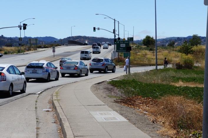
7 101/HILLSDALE INTERCHANGE Loop entrance ramps, heavy traffic, many conflict points


8 ROUTE 101 / HILLSDALE BLVD AREA MAP Hillsdale Blvd the east/west corridor Hillsdale Caltrain Station School Recreation Residential Commercial Transit Oriented Development (TOD) Foster City Freeway is barrier


9 Western Lookover Eastern Lookover


10 WESTERN CONNECTIONS Hillsdale Caltrain Station Bay Meadows TOD Kaiser Medical Center Hillsdale Corridor Hillsdale Shopping Center George Hall Elementary School San Mateo Village Neighborhood Casanova Park Laurie Meadows Park


11 EASTERN CONNECTIONS Westshore Neighborhood Foster City Marina Lagoon Trail Los Prados Neighborhood Bay Trail Los Prados Neighborhood Marina Shopping Plaza


12 LANDINGS Landing Approaches Intersections Safety Concerns
13 TREATMENT TOOLS LANDINGS INTERSECTIONS DEPARTMENT OF PUBLIC WORKS - STEWARDS OF THE INFRASTRUCTURE AND ENVIRONMENT

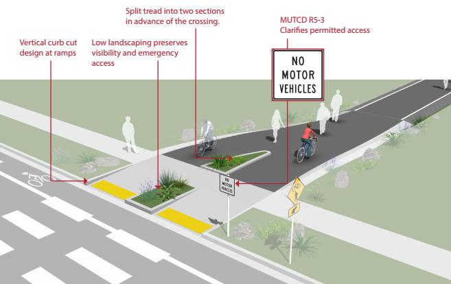
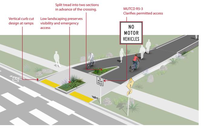
14 ENTRANCES & LANDING SAFETY TREATMENTS

 with rolled curb Varying")
15 ADDRESSING USER SAFETY NEAR INTERSECTIONS Through Design Dog leg curve Chicane Slope change Deflection devices that are low to the ground (4-6 or less) with rolled curb Varying pavement treatments


16 ADDRESSING USER SAFETY NEAR INTERSECTIONS Through Signs and Pavement Markings Warning signs and pavement legends Striping to highlight upcoming intersection Signs and markings should supplement a good design


17 OVERCROSSINGS 18.5 min.


18 TWO-STAGE TURN BOXES


19 BIKE BOX


20 CROSSWALKS


21 MARKED/UNSIGNALIZED CROSSWALKS
22 ACTIVE WARNING BEACONS


23 ROUTING USERS TO CROSSWALKS AT INTERSECTIONS


24 ADVANCE STOP AND YIELD LINES

25 PEDESTRIAN/BICYCLIST CROSSWALK (TOUCAN)


26 BICYCLE BOULEVARD WITH TOUCAN CROSSING
27 BOLLARD ALTERNATIVES

28 MINIMIZE CURB RETURN RADII
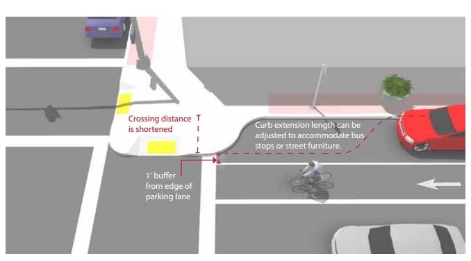
29 CURB EXTENSIONS/BULB OUTS

30 CHANNELIZED TURN LANES
31 BREAK OUT STATIONS (15 20 MINS) Station #1 - Connections Voting Vote for bridge connection variations based on how you would use the bridge Station #3 Landing and Intersection Toolbox Let us know what tools you prefer and how you would like to experience the bridge as a user Station #2 Safety Concerns Post Its Let us know how we can make your experience getting to the bridge more inviting DEPARTMENT OF PUBLIC WORKS - STEWARDS OF THE INFRASTRUCTURE AND ENVIRONMENT
32 REPORT BACK Station #1 - Connections Voting Vote for bridge connection variations based on how you would use the bridge Station #3 Landing and Intersection Toolbox Let us know what tools you prefer and how you would like to experience the bridge as a user Station #2 Safety Concerns Post Its Let us know how we can make your experience getting to the bridge more inviting DEPARTMENT OF PUBLIC WORKS - STEWARDS OF THE INFRASTRUCTURE AND ENVIRONMENT
33 NEXT STEPS -FUNDING Project phase funding: PSR-PDS phase Measure A grant through the SMCTA PA&ED phase Funding agreement with SMCTA fully executed Project is in SMC Bike/Ped Plan, SMCTA Expenditure Plan, City s General, Bicycle, and Pedestrian Master Plans DEPARTMENT OF PUBLIC WORKS STEWARDS OF THE INFRASTRUCTURE AND ENVIRONMENT
34 NEXT STEPS CALTRANS PROCESS Project Study Report Project Development Support (PSR-PDS) April 2013 Nov 2014 Project Approval and Environmental Documentation (PA&ED) Nov 2014 Oct 2015 Design Oct 2015 Nov 2016 Construction Jan 2017 Nov 2017 Begin preliminary design Propose all alignment alternatives to Caltrans Select viable options for further study Complete preliminary design Complete environmental clearance requirements Preferred alignment approved by Caltrans Complete PS&E design Obtain design exceptions from Caltrans Complete Construction
35 NEXT STEPS Public Works Commission and City Council Stay up to date by visiting: DEPARTMENT OF PUBLIC WORKS STEWARDS OF THE INFRASTRUCTURE AND ENVIRONMENT


36


37
 522-7316 tscramaglia@cityofsanmateo.org www.hillsdalebridge.")
38 PROJECT CONTACTS Aaron Lam Associate Engineer (650) Tracy Scramaglia Associate Engineer (650) DEPARTMENT OF PUBLIC WORKS STEWARDS OF THE INFRASTRUCTURE AND ENVIRONMENT
Agenda. Overview PRINCE GEORGE S PLAZA METRO AREA PEDESTRIAN PLAN
 PRINCE GEORGE S PLAZA METRO AREA PEDESTRIAN PLAN May 28, 2008 Agenda Welcome and introductions Project overview and issue identification Planning context and strengths Design challenges and initial recommendations
PRINCE GEORGE S PLAZA METRO AREA PEDESTRIAN PLAN
 PRINCE GEORGE S PLAZA METRO AREA PEDESTRIAN PLAN May 28, 2008 Agenda Welcome and introductions Project overview and issue identification Planning context and strengths Design challenges and initial recommendations
SR-203 Sidewalks and Town-Wide Mobility Improvements. Town Council Presentation September 7, 2016
 SR-203 Sidewalks and Town-Wide Mobility Improvements Town Council Presentation September 7, 2016 SR-203 Sidewalks and Town- Wide Mobility Improvements SR-203 Sidewalks and Appurtenances Town-Wide Mobility
Roosevelt Estates Neighborhood Improvements
 Roosevelt Estates Neighborhood Improvements Transportation Alternatives Application May 5 th, 2016 Qualifying Activities Construction of on-road and off-road trail facilities for pedestrians, bicyclists,
Existing Pedestrian Conditions. PSAC February 8, 2011
 Existing Pedestrian Conditions PSAC February 8, 2011 Contents 1. Project Background & Goals 2. Pedestrian Activity: Where people walk 3. Pedestrian Safety: The conditions people face Project Background
MOBILITY WORKSHOP. Joint City Council and Transportation Commission May 5, 2014
 MOBILITY WORKSHOP Joint City Council and Transportation Commission May 5, 2014 Review of General Plan M-1 Develop world-class transit system M-3 Maintain/enhance pedestrian-oriented City M-4 Create comprehensive
California Department of Transportation, District 4. Sloat Boulevard Project Skyline Blvd. to 19 th Ave. Community Update January 13, 2016
 California Department of Transportation, District 4 Sloat Boulevard Project Skyline Blvd. to 19 th Ave. Community Update January 13, 2016 Agenda Welcome and introductions Project overview, history and
City of Sammamish. Welcome. Issaquah-Fall City Road Improvements Project Phase I Design: 242nd Avenue SE to Klahanie Drive SE
 Welcome Welcome to the third community meeting for the Issaquah-Fall City Road Improvements Project. AGENDA 6:00 p.m. Welcome and sign-in 6:10 p.m. Presentation 6:50 p.m. Open house Learn about the roadway
01. VICINITY OF GREENBRAE POC: EXISTING CONDITIONS
 01. VICINITY OF GREENBRAE POC: EXISTING CONDITIONS Existing Bus Stop Existing US101 On-ramp Existing POC Old Redwood Highway Rich Street City ROW Environmental Study Limit Industrial Way NO DESIGNATED
San Jose Transportation Policy
 San Jose Transportation Policy Protected Intersections in LOS Policies to Support Smart Growth Presented by: Manuel Pineda City of San Jose Department of Transportation Bay Area Map San Francisco Oakland
San Mateo County Bicycle and Pedestrian Advisory Committee
 San Mateo County Bicycle and Pedestrian Advisory Committee January 19, 2017 Emma Shlaes, Policy Manager About SVBC Mission Our purpose is to create a healthy community, environment, and economy through
TRAFFIC ACTION PLAN. Laurie Meadows Neighborhood CITY OF SAN MATEO
 TRAFFIC ACTION PLAN Laurie Meadows Neighborhood CITY OF SAN MATEO Draft January 2017 Table of Contents Introduction... 2 The Traffic Forum Process... 5 Neighborhood Traffic Issues... 7 Neighborhood Recommendations
Appendix T CCMP TRAIL TRAFFIC & TRANSPORTATION DESIGN STANDARD
 Appendix T CCMP 3.3.4 TRAIL TRAFFIC & TRANSPORTATION DESIGN STANDARD 3.3.4 Trail Traffic and Transportation Design Multi-use trails have certain design standards, which vary depending on the agency that
Los Altos Hills Town Council - June 18, 2015 Palo Alto City Council June 22, AGENDA ITEM #2.B Presentation
 Los Altos Hills Town Council - June 18, 2015 Palo Alto City Council June 22, 2015 AGENDA ITEM #2.B Presentation Previous Presentations Los Altos Hills Town Council in May 2014 and February 2015 Palo Alto
Watertown Complete Streets Prioritization Plan. Public Meeting #1 December 14, 2017
 Watertown Complete Streets Prioritization Plan Public Meeting #1 December 14, 2017 Goals for Public Meeting Overview of MassDOT Complete Streets Funding Program Educate the community on Complete Streets
SETTINGS AND OPPORTUNITIES MOBILITY & ACCESS
 7 mobility & access how do people use el camino what is it like to drive on el camino/to park along el camino what is the pedestrian experience like what is the role of transit along the corridor what
C/CAG. Sunnybrae Elementary School Walking and Bicycling Audit. San Mateo-Foster City School District JUNE 2013
 Sunnybrae Elementary School Walking and Bicycling Audit JUNE 2013 San Mateo-Foster City School District C/CAG City/County Association of Governments of San Mateo County SUNNYBRAE ELEMENTARY SCHOOL WALKING
CRESTON ROAD COMPLETE AND SUSTAINABLE STREETS CORRIDOR PLAN
 CRESTON ROAD COMPLETE AND SUSTAINABLE STREETS CORRIDOR PLAN Preferred Plan Community Presentation September 27, 2017 City of El Paso de Robles in partnership with: Local Government Commission, W-Trans,
PRESS RELEASE San Joaquin Council of Governments
 PRESS RELEASE San Joaquin Council of Governments For Immediate Release February 23, 2018 Contact: Nicole Gorham, 235-0582 gorham@sjcog.org SJCOG Board Awards $19.63 Million in Measure K Bicycle, Pedestrian,
Transportation Planning Division
 Transportation Planning Division Presentation Outline Study Tasks Recap of Previous Meetings Data Collected Focus Areas within Study Limits Design Principles Tool Box Recommended Concepts Schedule Moving
City of San Mateo Bicycle Master Plan. Adopted October 17, PREPARED BY: Alta Planning + Design. PREPARED FOR: The City of San Mateo
 City of San Mateo Bicycle Master Plan Adopted October 17, 2011 PREPARED BY: Alta Planning + Design PREPARED FOR: The City of San Mateo City of San Mateo Bicycle Master Plan Adopted October 17, 2011 Updated
The Wiggle Route in Context
 The Wiggle Route in Context In a city of hills, the Wiggle is an important route because it winds its way along the flattest streets from Market to the Panhandle, bringing residents to local parks and
Detailed Description of Work
 Trail Items I-580 Eastbound Shoulder Running Lane and Bi-Directional Bike Lane Project Bay Area Toll Authority Task Order Contract with HNTB Corporation Effective May 12, 2014 Description of Work: Implement
Off-road Trails. Guidance
 Off-road Trails Off-road trails are shared use paths located on an independent alignment that provide two-way travel for people walking, bicycling, and other non-motorized users. Trails specifically along
City of Davis East Covell Corridor Plan
 Community Open House #2 January 22, 2014 6:00 8:00 p.m. Veterans Memorial Center, Club Room City of Davis Introduction The (ECCP) is a taking a comprehensive look at the existing transportation systems
City of Wilsonville 5 th Street to Kinsman Road Extension Project
 City of Wilsonville 5 th Street to Kinsman Road Walking Tour & Neighborhood Workshop Summary Report Public Outreach Overview On July 18 th, 2017, the City of Wilsonville hosted a neighborhood walking tour
MASTER BICYCLE AND PEDESTRIAN PLAN
 VILLAGE OF NORTHBROOK MASTER BICYCLE AND PEDESTRIAN PLAN DRAFT PLAN OPEN HOUSE May 2, 2018 AGENDA 1. Community Engagement 2. Vision and Goals 3. General Structure of Plan 4. Recommendations Overview 5.
Appendix C. TRAFFIC CALMING PROGRAM TOOLBOX
 Appendix C. TRAFFIC CALMING PROGRAM TOOLBOX PHASE I...2 Do Not Enter Sign...3 One-Way Sign...4 Turn Prohibition...5 Pavement Markings...6 Speed Monitoring Trailer...7 Neighborhood Speed Watch...8 Police
Appendix A. Knoxville TPO Greenway Signage Guidelines. Appendix A: Knoxville TPO Greenway Signage Guidelines Knox to Oak Ridge Greenway Master Plan
 Appendix A Knoxville TPO Greenway Signage Guidelines 75 Overview: Adequate signing and marking are essential on shared-use paths, especially to alert bicyclists to potential conflicts and to convey regulatory
FEDERAL HIGHWAY ADMINISTRATION APPLICATION
 FEDERAL HIGHWAY ADMINISTRATION APPLICATION REQUEST FOR PERMISSION TO EXPERIMENT WITH A BICYCLE BOX INTERSECTION TREATMENT Submitted by: City of Columbus Department of Public Service Date: June 26, 2009
Lee s Summit Road Improvement Study Public Open House June 7, 2007 Summary of Comment Card Responses
 Lee s Summit Road Improvement Study Public Open House June 7, 2007 Summary of Comment Card Responses Introduction At the Lee s Summit Road Improvement Study Public Open House held Thursday, June 7, 2007
Merrick and Memorial Neighborhood Study 5/14/2014 Public Meeting
 Merrick and Memorial Neighborhood Study 5/14/2014 Public Meeting Study Area April 9 Public Meeting Comments Summary Pedestrian Safety - A Walking Neighborhood Pedestrian traffic is very difficult A need
TRANSPORTATION MASTER PLAN Review Citywide Recommendations, Updated List and Scoring Methodology December 6, 2018
 NOTE: Due to lengthy Committee discussion and allotted meeting time, slides 12-35 were not presented at the meeting, but are provided here for reference. TRANSPORTATION MASTER PLAN Review Citywide Recommendations,
Freeway ramp intersection study
 Freeway ramp intersection study Supporting Vision Zero: Zero traffic deaths in San Francisco by 2024 Study Goals: Primary Improve Safety Improve Accessibility Secondary Provide Efficient Circulation Accommodate
Bicycle and Pedestrian Advisory Committee (BPAC) November 21, 2013
 November 21, 2013") Bicycle and Pedestrian Advisory Committee (BPAC) November 21, 2013 OVERALL LAND USE CONCEPT Overall Broadway Valdez District: 95.5 acres (35.1 acres right-of ways + 60.4 acres developable land) Plan Subareas:
Bicycle and Pedestrian Advisory Committee (BPAC) November 21, 2013 OVERALL LAND USE CONCEPT Overall Broadway Valdez District: 95.5 acres (35.1 acres right-of ways + 60.4 acres developable land) Plan Subareas:
Cottonwood Heights HAWK Pedestrian Crossing on Fort Union Blvd. Project Type Capital Improvement
 Cottonwood Heights HAWK Pedestrian Crossing on Fort Union Blvd. At West Side of Mountview Park Entrance (Approx. 1600 East) $ 206,800 $ 192,800 Install a HAWK Pedestrian Crossing System on Fort Union Boulevard,
Bicycle + Pedestrian Connectivity Gap Analysis
 Accelerated Bridge Program Bicycle + Pedestrian Connectivity Gap Analysis Tuesday, October 11 Shriners Hospital, Boston 6:30-8:00 PM Thursday, October 13 Community Rowing, Brighton 6:30-8:00 PM Tuesday,
MOUNTAIN HOUSE SPECIFIC PLAN I 9.1 INTRODUCTION ASSUMPTIONS TRANSPORTATION FACILITIES TRANSPORTATION IMPROVEMENTS PHASING 9.
 CHAPTER NINE: TRANSPORTATION AND CIRCULATION 9.1 INTRODUCTION 9.1 9.2 ASSUMPTIONS 9.1 9.3 TRANSPORTATION FACILITIES 9.1 9.4 TRANSPORTATION IMPROVEMENTS PHASING 9.3 LIST OF FIGURES LIST OF TABLES Figure
El Camino Real Specific Plan. TAC/CAC Meeting #2 Aug 1, 2018
 El Camino Real Specific Plan TAC/CAC Meeting #2 Aug 1, 2018 Land Use Alternatives Goals and Tradeoffs Parks & open space Housing Retail & services Civic spaces Parking Community gathering spaces 3 Alternatives
Transportation 6. A. Transit Center Circulation and Access. 1. Transit Center Circulation
 Transportation 6 This chapter describes the transportation system in and around the Hillsdale Station Area, with a focus on the Transit Center at the relocated Hillsdale Caltrain Station. The transportation
WELCOME. Thank you for joining us at the Second Public Workshop for the Carlsbad Pedestrian Master Plan. We look forward to receiving your feedback.
 City of Carlsbad Pedestrian Master Plan: WELCOME WELCOME Please Sign In Provide Input at Flip Charts Review Boards Presentation of Draft Plan Thank you for joining us at the Second Public Workshop for
Tonight is for you. Learn everything you can. Share all your ideas.
 Strathcona Neighbourhood Renewal Draft Concept Design Tonight is for you. Learn everything you can. Share all your ideas. What is Neighbourhood Renewal? Creating a design with you for your neighbourhood.
TRANSPORTATION TRAINING TOPICS. April 6, 2010
 TRANSPORTATION TRAINING TOPICS April 6, 2010 Roles of Transportation Providers Context and Policy Makers Division of Transportation and Traffic Other City Operations Other Transportation Operators CMA
Orinda Bicycle, Trails and Walkways Master Plan
 Orinda Bicycle, Trails and Walkways Master Plan Public Meeting October 15, 2008 Presented by: Ian Moore, Alta Lauren Ledbetter, Alta Bruce Wolff, Alta Introductions City of Orinda Monica Pacheco, Assistant
Water Street Promenade Engineering and Design Services
 Preliminary Design Presentation Parking & Traffic Safety Committee Water Street Promenade Engineering and Design Services July 16,2014 November 3, 2016 Education / Infrastructure / Innovation 1 Project
Financial Project ID No(s).: and ETDM No(s).: and 14181
.: and ETDM No(s).: and 14181") Palm Beach Metropolitan Planning Organization (MPO) Presentation I-95 at Boynton Beach Boulevard Interchange and I-95 at Gateway Boulevard Interchange Project Development and Environment Study Palm Beach
Palm Beach Metropolitan Planning Organization (MPO) Presentation I-95 at Boynton Beach Boulevard Interchange and I-95 at Gateway Boulevard Interchange Project Development and Environment Study Palm Beach
SAN MATEO COUNTY TRANSPORTATION AUTHORITY STAFF REPORT
 SAN MATEO COUNTY TRANSPORTATION AUTHORITY STAFF REPORT AGENDA ITEM # 10 (a) MARCH 3, 2016 TO: THROUGH: Transportation Authority Jim Hartnett Executive Director FROM: April Chan Eli Kay Gigi Harrington
» Draft Recommendations» Discussion» Next Steps. Plan for Walking and Biking
 SAC Meeting Plan #3 for September Walking and 12, Biking 2018 » Draft Recommendations» Discussion» Next Steps Plan for Walking and Biking » Stakeholder and Public Outreach» Background data collection and
Bike San Mateo County San Mateo County Bicycle Plan Recommendations August 30, 2010
 Policy and Procedures Develop and Implement a Complete Streets Policy to comply with DD-64-R1 and AB1358 Commencing January 1, 2011, AB1358 requires that the legislative body of a city or county, upon
AUTHORIZE BID ADVERTISEMENT
 STAFF REPORT MEETING DATE: May 17, 2016 TO: City Council FROM: Petr Skala, Assistant Engineer PRESENTER: Russell Thompson, Public Works Director 922 Machin Avenue Novato, CA 94945 415/ 899-8900 FAX 415/
PROPOSED BICYCLE AND PEDESTRIAN FACILITY Vicinity of Route 123/I-495 Interchange Tysons, Fairfax County, Virginia
 PROPOSED BICYCLE AND PEDESTRIAN FACILITY Vicinity of Route 123/I-495 Interchange Tysons, Fairfax County, Virginia PRELIMINARY ENGINEERING REPORT Prepared for: Prepared by: July 2017 Table of Contents 1
Multi-Modal Traffic Analysis. Parisi and Associates
 Mill Valley to Corte Madera Bicycle and Pedestrian Corridor Study Appendix D: Multi-Modal Traffic Analysis Prepared by Parisi and Associates August 2009 Appendix D - Multi-Modal Traffic Analysis Table
West Circle Drive (CSAH 22) Traffic Operations Study
 Traffic Operations Study") West Circle Drive (CSAH 22) Traffic Operations Study May 24, 2016 Open House Harriet Bishop Elementary School 6:45 8:00 p.m. Presentation at 7:00 p.m. Purpose of Tonight s Meeting Introductions Explain
West Circle Drive (CSAH 22) Traffic Operations Study May 24, 2016 Open House Harriet Bishop Elementary School 6:45 8:00 p.m. Presentation at 7:00 p.m. Purpose of Tonight s Meeting Introductions Explain
ACTION TRANSMITTAL No
 Transportation Advisory Board of the Metropolitan Council of the Twin Cities DATE: August 25, 2016 TO: FROM: ACTION TRANSMITTAL No. 2016-47 Technical Advisory Committee TAC Funding and Programming Committee
Caltrans Sloat Boulevard Pedestrian Safety Project Response to Community Questions, Comments & Concerns
 Caltrans Sloat Boulevard Pedestrian Safety Project Response to Community Questions, Comments & Concerns Revised: May 10, 2016 The California Department of Transportation (Caltrans) is planning various
6.4 RECOMMENDED IMPROVEMENTS
 6.4 RECOMMENDED IMPROVEMENTS 6.4.1 Williston Road Recommendations While all alternatives would be an improvement over existing conditions, Alternative 3B is recommended over the others because it provides
Ocean Park Boulevard Green Street Project Community Workshop
 Ocean Park Boulevard Green Street Project Community Workshop 2.2.10 Project Objectives Community Priority: reclaim OPB for public open space. Build upon LUCE principles; neighborhood enhancement, connectivity,
NJDOT Complete Streets Checklist
 Background The New Jersey Department of Transportation s Complete Streets Policy promotes a comprehensive, integrated, connected multi-modal network by providing connections to bicycling and walking trip
Pedestrian Project List and Prioritization
 To: Kyle Wagenschutz, City of Memphis CC: From: Anne Conlon and John Cock, Alta Planning + Design Date: December, 2014 Re: Project List Development (Task 3.1-3.2) and Project List Prioritization (Task
Chapter 13 ORANGE COVE
 Chapter 13 ORANGE COVE This chapter describes the current status and future plans for biking and walking in the City of Orange Cove. RELATIONSHIP TO CITY PLANS AND POLICIES The Orange Cove General Plan
San Mateo County Comprehensive Bicycle and Pedestrian Plan Open House
 San Mateo County Comprehensive Bicycle and Pedestrian Plan Open House October 28, 2010 Presented to San Mateo County residents and interested parties by Lauren Ledbetter, Alta Planning + Design Matt Haynes,
Central Freeway and Octavia Circulation Study
 Central Freeway and Octavia Circulation Study Final Report Plans and Programs Committee San Francisco County Transportation Authority September 18, 2012 Presentation Outline Background and Study Purpose
Brooklyn Boulevard (County Road 152) Reconstruction Project Phase I. OPEN HOUSE June 20, 2017
 Reconstruction Project Phase I. OPEN HOUSE June 20, 2017") Brooklyn Boulevard (County Road 152) Reconstruction Project Phase I OPEN HOUSE June 20, 2017 Brooklyn Boulevard (County Road 152) Phase I Project Partners Project Lead Other Project Partners include Brooklyn
Brooklyn Boulevard (County Road 152) Reconstruction Project Phase I OPEN HOUSE June 20, 2017 Brooklyn Boulevard (County Road 152) Phase I Project Partners Project Lead Other Project Partners include Brooklyn
TRAFFIC ACTION PLAN. Central Neighborhood CITY OF SAN MATEO
 TRAFFIC ACTION PLAN Central Neighborhood CITY OF SAN MATEO Draft January 2017 Table of Contents Introduction... 1 The Traffic Forum Process... 4 Neighborhood Traffic Issues... 7 Neighborhood Recommendations
Bicycle and Pedestrian Connectivity Study. Old Colony Planning Council
 Bicycle and Pedestrian Connectivity Study Old Colony Planning Council Outline Why consider bike/peds in road designs? Why are measures needed? Connecting Land Use with Transportation Evaluation Tools:
Bicycle and Pedestrian Chapter TPP Update Overview. TAB September 20, 2017
 Bicycle and Pedestrian Chapter TPP Update Overview TAB September 20, 2017 Bicycling & Walking in the Twin Cities Where are we now? The Bike-Pedestrian system Current trends New developments Where are we
Welcome to the Sellwood Bridge Project Open House!
 Welcome to the Sellwood Bridge Project Open House! 5:30 7:30 pm Please sign in here Information stations and project staff are located throughout the room. Goals for Tonight s Meeting: Learn how the Preferred
San Rafael School District. Task Force Meeting Notes. November 5, 2012
 San Rafael School District Task Force Meeting Notes November 5, 2012 Attendees (8) Wendi Kallins Program Director for Safe Routes to Schools; Laura Kelly Volunteer Liaison for Safe Routes to Schools; Leslie
Bicycle Transportation Budget Plan: Lawrence, KS
 Bicycle Transportation Budget Plan: Lawrence, KS Bicycle Objectives Lawrence Planning Documents Establish a dedicated funding plan to complete the implementation of a bikeway system plan, and for maintenance
Queensboro Bridge Bus Priority Study: Summary of Recommendations. Presentation to Manhattan Community Board 8 May 4, 2011
 : Summary of Recommendations Presentation to Manhattan Community Board 8 May 4, 2011 1 Overview Study Goal: Identify cost-effective ways to improve bus speed and reliability for local and express buses
Implementing Complete Streets in Ottawa. Project Delivery Process and Tools Complete Streets Forum 2015 October 1, 2015
 Implementing Complete Streets in Ottawa October 1, 2015 The Essentials Complete Streets Implementation Framework will become part of the routine delivery of City transportation projects Approach uses every
BICYCLE AND TRAILS ADVISORY COMMISSION Meeting Minutes
 Minutes Approved as Submitted Date: 8/10/17 Initials: EC BICYCLE AND TRAILS ADVISORY COMMISSION Meeting Minutes June 8, 2017 The Bicycle and Trails Advisory Commission was called to order at 4:00 p.m.
SAFE ROUTES TO SCHOOL (SR2S)
") SAFE ROUTES TO SCHOOL (SR2S) In partnership with Burbank Unified School District (BUSD) & City of Burbank George Washington Elementary School Thomas Jefferson Elementary School John Muir Middle School
SAFE ROUTES TO SCHOOL (SR2S) In partnership with Burbank Unified School District (BUSD) & City of Burbank George Washington Elementary School Thomas Jefferson Elementary School John Muir Middle School
Advancing Transportation Choices in Des Moines. MPO Environmental Roundtable January 9, 2018
 Advancing Transportation Choices in Des Moines MPO Environmental Roundtable January 9, 2018 Presented by Jennifer McCoy, PE, PTOE City Traffic Engineer Agenda Des Moines Area Transportation Planning Connect
EXECUTIVE SUMMARY... vii 1 STUDY OVERVIEW Study Scope Study Area Study Objectives
 Contents EXECUTIVE SUMMARY... vii 1 STUDY OVERVIEW... 1-1 1.1 Study Scope... 1-1 1.2 Study Area... 1-1 1.3 Study Objectives... 1-3 2 EXISTING CONDITIONS... 2-1 2.1 Existing Freeway Conditions... 2-4 2.1.1
Broad Street Bicycle Boulevard Design Guidelines
 Broad Street Bicycle Boulevard Design Guidelines Building from the strategies introduced in the 2013 Bicycle Transportation Plan and community input received thus far, City Transportation Staff have identified
Duwamish Way-finding and CTR Report
 V. North Tukwila When the North Tukwila Manufacturing and Industrial Center was designated in 1992 as part of the region s land use and transportation plan, the plan called for the area to set a light-rail
Major Bike Routes 102 Avenue Workshop April 21, 2015
 Major Bike Routes 102 Avenue Workshop April 21, 2015 Our Purpose Today Provide context on how Major Bike Routes fit into Edmonton s future Share information on what we heard in our last phase, and how
Item No. 14 Town of Atherton
 Item No. 14 Town of Atherton CITY COUNCIL STAFF REPORT CONSENT AGENDA TO: THROUGH: FROM: HONORABLE MAYOR AND CITY COUNCIL GEORGE RODERICKS, CITY MANAGER MICHAEL KASHIWAGI, COMMUNITY SERVICES DIRECTOR MARTY
TOWN OF MORAGA. CAMINO PABLO & CANYON ROAD INTERSECTION IMPROVEMENTS Public Information Meeting February 20, 2019
 TOWN OF MORAGA CAMINO PABLO & CANYON ROAD INTERSECTION IMPROVEMENTS Public Information Meeting February 20, 2019 Edric Kwan, Public Works Director April Malvino Miller, BKF Project Design Manager Shawn
Bicycle and Pedestrian Plans and Improvements
 Bicycle and Pedestrian Plans and Improvements Presented to the City Council By Randle Harwood, Planning and Development, and Richard Zavala, Parks and Community Services September 24, 2013 Purpose Review
TRAFFIC CALMING TOOLBOX
 TRAFFIC CALMING TOOLBOX Traffic control devices are those official signs and striping placed in the public right-of-way and recognized by the public such as STOP signs, curve warning signs, centerline
Meadow Woods Elementary School
 Drag and drop pic and stretch/crop to the limits of the blue rectangle (delete this text box) Meadow Woods Elementary School Drag and drop pic and stretch/crop to the limits of the blue rectangle (delete
Transportation Planning Division
 Transportation Planning Division Presentation Outline Study Tasks Recap of Previous Meeting Stakeholder Interviews Data Collection Design Principles Tool Box Recommendations Schedule Moving Forward North
CITY OF ANN ARBOR TRAFFIC CALMING PROGRAM PROCESS OVERVIEW. Petitioner defines the project area limits and gathers petition signatures.
 CITY OF ANN ARBOR TRAFFIC CALMING PROGRAM PROCESS OVERVIEW Step 1: Petition Petitioner defines the project area limits and gathers petition signatures. 50% of addresses within the project area must sign
CHIEF PEGUIS TRAIL EXTENSION WEST
 1 PRELIMINARY DESIGN OF THE CHIEF PEGUIS TRAIL EXTENSION WEST Public Information Session June 6, 2017 Welcome 1 Thank you for attending today s public information session. The following boards provide
10.0 CURB EXTENSIONS GUIDELINE
 10.0 CURB EXTENSIONS GUIDELINE Road Engineering Design Guidelines Version 1.0 March 2017 City of Toronto, Transportation Services City of Toronto Page 0 Background In early 2014, Transportation Services
Bicycle Facilities Planning
 Bicycle Facilities Planning Overview Types of Cyclists Purpose for Riding Types of Facilities Bike Lanes Bicycle Boulevards Cycle Tracks Intersections Signals Signing and Marking Discussion Types of Bicyclists
Arlington Public Schools New Elementary School at Thomas Jefferson Site Off-Site Transportation. Thomas Jefferson BLPC / PFRC Meeting July 27, 2016
 Arlington Public Schools New Elementary School at Thomas Jefferson Site Off-Site Transportation Thomas Jefferson BLPC / PFRC Meeting July 27, 2016 1.Review of Analysis 2.Key Transportation Issues 3.Recommendations
MEASURE B AND MEASURE BB Annual Program Compliance Report Reporting Fiscal Year AGENCY CONTACT INFORMATION
 MEASURE B AND MEASURE BB Annual Program Compliance Report Reporting Fiscal Year 2016-2017 AGENCY CONTACT INFORMATION Agency Name: City of Livermore Date: 12/4/2017 Primary Point of Contact Name: Debbie
5 CIRCULATION AND STREET DESIGN
 5 CIRCULATION AND STREET DESIGN This chapter describes circulation and streetscape improvements proposed for the Northwest Chico Specific Plan Area. It includes detailed design specifications for existing
Bikeway action plan. Bicycle Friendly Community Workshop March 5, 2007 Rochester, MN
 Bikeway action plan Summary The was held on March 5, 2007 at the Rochester Mayo Civic Center. The workshop was hosted by Rochester-Olmsted County Planning Department in collaboration with the League of
Who is Toole Design Group?
 2018 AASHTO Bike Guide Status Update NCHRP 15 60 Amalia Leighton Cody, PE, AICP & Kenneth Loen, PE Washington APWA October 4, 2018 Who is Toole Design Group? TDG is a full service engineering, planning
Mandan Commission Meeting August 2, 2016 Mandan City Hall
 Mandan-Bismarck Corridor Improvement Study Mandan Commission Meeting August 2, 2016 Mandan City Hall 2014 HDR, Inc., all rights reserved. Mandan Corridors Study Schedule 2015 2016 Study Kick Off August
Bicycle-Pedestrian Master Plan: Chapters 3 and 4 Distribution
 Bicycle-Pedestrian Master Plan: Chapters 3 and 4 Distribution Finksburg Planning and Citizens Council March 22, 2018 Overview Progress Citizen Outreach Vision Chapter 3 - Existing Conditions Chapter 4
GIS Based Data Collection / Network Planning On a City Scale. Healthy Communities Active Transportation Workshop, Cleveland, Ohio May 10, 2011
 The Purpose of GIS Based Network Planning GIS Based Data Collection / Network Planning Healthy Communities Active Transportation Conference Tuesday, May 10, 2011 10:00 AM Norman Cox, LLA, ASLA. Ann Arbor,
Guidance. ATTACHMENT F: Draft Additional Pages for Bicycle Facility Design Toolkit Separated Bike Lanes: Two-Way to One-Way Transitions
 ATTACHMENT F: Draft Additional Pages for Bicycle Facility Design Toolkit Separated Bike Lanes: Two-Way to One-Way Transitions This treatment provides a transition from two-way separated bike lanes to one-way
RE: Natomas Landing (P99-091)
") August 2, 2008 David Hung, Associate Planner Current Planning Division Development Services Department 300 Richards Boulevard, 3rd Floor Sacramento, CA 95811 RE: Natomas Landing (P99-091) Dear Mr. Hung:
August 2, 2008 David Hung, Associate Planner Current Planning Division Development Services Department 300 Richards Boulevard, 3rd Floor Sacramento, CA 95811 RE: Natomas Landing (P99-091) Dear Mr. Hung:
Improvements Infrastructure Gap Assessment and Improvements Street Striping
 Infrastructure Project Proposal The federal-aid Safe Routes to School program funds infrastructure/engineering projects that fall into two categories: Design (available only to School Development Authority
City of Birmingham Draft Multi-modal Transportation Plan
 City of Birmingham Draft Multi-modal Transportation Plan City Commission Public Hearing Monday, November 25, 2013 7:30 pm Norman Cox, PLA, ASLA The Greenway Collaborative, Inc. Ann Arbor, Michigan The