Arlington Public Schools New Elementary School at Thomas Jefferson Site Off-Site Transportation. Thomas Jefferson BLPC / PFRC Meeting July 27, 2016
|
|
|
- Eugene Daniels
- 5 years ago
- Views:
Transcription

1 Arlington Public Schools New Elementary School at Thomas Jefferson Site Off-Site Transportation Thomas Jefferson BLPC / PFRC Meeting July 27, 2016
2 1.Review of Analysis 2.Key Transportation Issues 3.Recommendations a.safety b.pedestrian and Bicycle Access/Circulation c. Congestion and Vehicle Access/Circulation
3 Estimated future parking Location of on-site transportation facilities (e.g., accessible walkways, bus and parent pick-up and drop-off) Construction phase circulation, access and safety Traffic and speed around the school Off-site infrastructure improvements to support safe access and circulation for all travel modes School programs that support more walking, biking, carpooling, bus and transit use
4 Estimated future parking Location of on-site transportation facilities (e.g., accessible walkways, bus and parent pick-up and drop-off) Construction phase circulation, access and safety Traffic and speed around the school Off-site infrastructure improvements to support safe access and circulation for all travel modes School programs that support more walking, biking, carpooling, bus and transit use Focus of 07/27 presentation
5 Mode % Student and staff surveys from 2014 Additional student surveys in 2013 & 2015 Survey data reviewed for TJ, Henry, and all APS neighborhood middle and elementary schools 50% 45% 40% 35% 30% 25% 20% 15% 10% 5% 0% Student Travel Tally Travel Mode % 42% 30% 30% 21% 21% 2% 3% 3% 3% 0% 0% 1% 1% Walk Bike School Bus Family Vehicle Carpool Transit Other Mode Type Arrival Dismissal

6 Arrival and dismissal observations conducted in 2014 and 2016 Count people by mode Observe behavior & issues Observation Locations N

7 Three years of crash data Crash data doesn t capture near misses or close calls Arlington Blvd and Glebe Road - most crashes typical of highvolume roads Seven crashes involved pedestrians Two crashes involved bicycles
8 Data Collection Locations Turning Movement Counts Automatic Traffic Recorder (ATR)
9 2 nd Street Speed Data Overall Speed Limit: 25 MPH 85 th Percentile Speed: 30 MPH During Arrival and Dismissal School Zone Speed Limit: 20 MPH 85 th Percentile Speed: 27MPH/29MPH (AM/PM)
10 12:00 AM 1:00 AM 2:00 AM 3:00 AM 4:00 AM 5:00 AM 6:00 AM 7:00 AM 8:00 AM 9:00 AM 10:00 AM 11:00 AM 12:00 PM 1:00 PM 2:00 PM 3:00 PM 4:00 PM 5:00 PM 6:00 PM 7:00 PM 8:00 PM 9:00 PM 10:00 PM 11:00 PM TRAFFIC ANALYSIS Non-School Related Traffic and School Peak Hours Non-School- Related Average Hourly Weekday Traffic on 2nd Street S Middle School Peak Hours Elementary School Peak Hours
11 7:00 AM 7:05 AM 7:10 AM 7:15 AM 7:20 AM 7:25 AM 7:30 AM 7:35 AM 7:40 AM 7:45 AM 7:50 AM 7:55 AM 8:00 AM 8:05 AM 8:10 AM 8:15 AM 8:20 AM 8:25 AM 8:30 AM 8:35 AM 8:40 AM 8:45 AM 8:50 AM 8:55 AM 9:00 AM 9:05 AM 9:10 AM TRAFFIC ANALYSIS Middle and Elementary School Traffic Volume: Arrival Neighborhood ES Trips At Capacity MS Trips Combined Bell Times At-Capacity Middle School & Proposed Elementary School Traffic Pattern

12 Delay, similar to existing conditions Slight increase in delay Greater increase in delay Locations Experiencing Vehicle Delay Arrival NB & SB Arlington Blvd & Irving St SB 2 ND St & Irving St WB & NB 2 nd St and Glebe Rd NB & SB 2 nd St and Old Glebe Rd
13 Evaluation Location
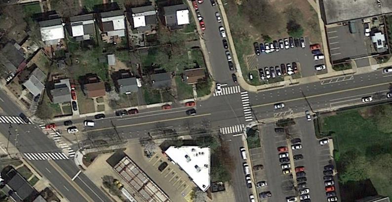
14 1. Congestion at 2 nd Street S and South Old Glebe 2. Vehicle Speed on 2 nd Street S 3. Reported wrong way driving and speed on 1 st Road S 4. Pedestrian/ADA and Bicycle Access to Site
15 Near-term indicates projects that are recommended for completion before the new elementary school opens on the TJ campus. Projects may be implemented by APS, the County, or through the joint fund. Longer-term indicates projects that are recommended for consideration and implementation by the County.

16 Near-term APS/County projects Longer-term County projects 4f 4g 4h 4e 4a 3 4c 4b 1 4d 2b 2a
17
18 1a Add dedicated southbound right turn lane on S Old Glebe
19 1b Install 4-way stop signs

20 1c Consider alternative drop off location on 2 nd Street

21 1d Consider a mini-roundabout
22 Example from Bel Air, MD Intersection of Tollgate & MacPhail
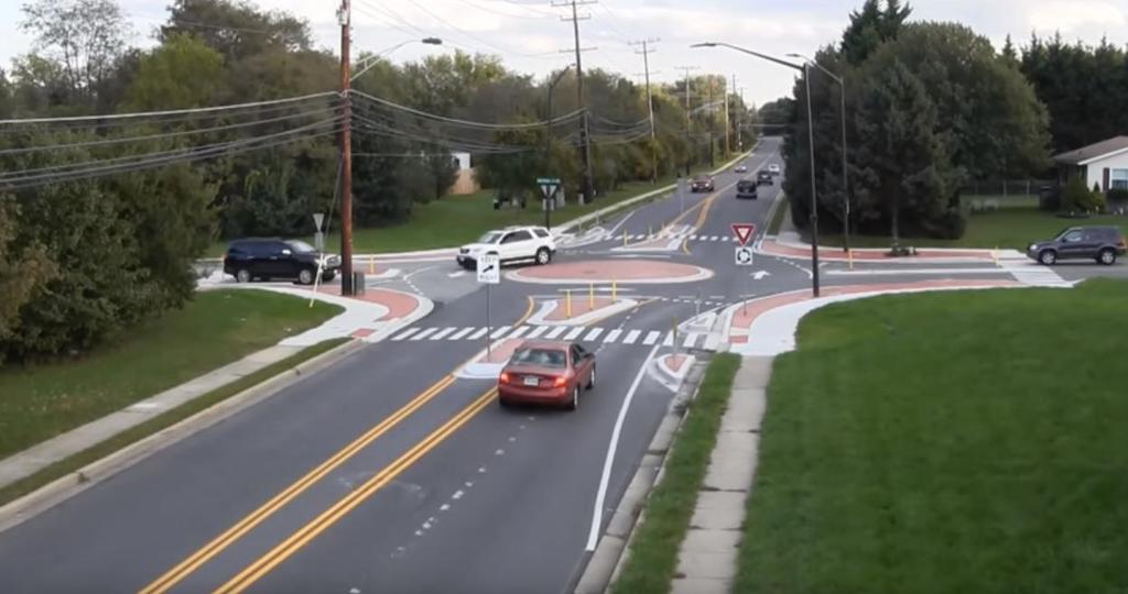
23 1d Consider a mini-roundabout

24 1d Consider a mini-roundabout
25

26 2a Install raised crosswalk & rapid flashing beacon in front of community center

27 2b If no mini-roundabout, install additional raised crosswalk near western driveway of community center
28

29 3a Continue to partner with the County to explore options such as increased enforcement, rumble strips, signage or other interventions Data collected in 2004, 2007, 2012 and 2014 No U-Turn sign and a One-Way sign to be installed by mid-august
30

31 4a Upgrade curb ramps and widen sidewalks on school site and at adjoining intersections
32 4b S Old Glebe and 1 st Road S: Curb extensions to shorten crossing distance and encourage yielding to pedestrians

33 4c S Glebe Rd and 2 nd St S: restripe crosswalk & consider signal timing adjustments


34 4d Consider closing western driveway of Dominion Arms parking lot


35 4e Replace/repair sidewalk on west side of S Old Glebe to provide 4 clear width, address heaves and provide ADA ramps


36 4f Install sidewalk and improve trail along Route 50 to provide improved connectivity along north side of site; improve bus stop access County project already planned for implementation summer 2016


37 4g Pedestrian Bridge over Route 50: Explore improving traction in cold or wet weather & add edge striping to trail at bridge entrance improve visibility in low light conditions


38 4h Stripe new crosswalk on Irving Street near Route 50 intersection
39 Discussion / Questions
Arlington Public Schools Thomas Jefferson Site Evaluation Transportation Networks. Thomas Jefferson Working Group Meeting #6 November 10, 2014
 Arlington Public Schools Thomas Jefferson Site Evaluation Transportation Networks Thomas Jefferson Working Group Meeting #6 November 10, 2014 2 3 INTRODUCTION 4 Goal of our work: Identify and assess multi-modal
Arlington Public Schools Thomas Jefferson Site Evaluation Preliminary Findings. Thomas Jefferson Working Group Meeting #2 October 1, 2014
 Arlington Public Schools Thomas Jefferson Site Evaluation Preliminary Findings Thomas Jefferson Working Group Meeting #2 October 1, 2014 SAN ANTONIO BEXAR COUNTY PEDESTRIAN SAFETY ACTION PLAN INTRODUCTION
APS Stratford Project Transportation Analysis Overview. Stratford BLPC #5 June 1, 2015
 APS Stratford Project Transportation Analysis Overview Stratford BLPC #5 June 1, 2015 8 Arrival/dismissal observations and counts BLPC arrival/dismissal observations BLPC early release observation Williamsburg
Arlington Public Schools Abingdon Elementary School Site Evaluation Preliminary Transportation Findings
 Arlington Public Schools Abingdon Elementary School Site Evaluation Preliminary Transportation Findings Arlington County Public Facilities Review Committee (PFRC) November 19, 2014 SAN ANTONIO-BEXAR COUNTY
C/CAG. Sunnybrae Elementary School Walking and Bicycling Audit. San Mateo-Foster City School District JUNE 2013
 Sunnybrae Elementary School Walking and Bicycling Audit JUNE 2013 San Mateo-Foster City School District C/CAG City/County Association of Governments of San Mateo County SUNNYBRAE ELEMENTARY SCHOOL WALKING
Abingdon Elementary School School Transportation Report
 Abingdon Elementary School School Transportation Report May 2015 Prepared for Arlington Public Schools by Toole Design Group, LLC 1 CONTENTS Executive Summary... 3 Introduction... 7 Existing Conditions
COMMUNITY MEETING AGENDA
 COMMUNITY MEETING AGENDA Welcome and Introductions SAFE Presentation Project Presentation Priorities Feedback Next Steps Q&A Santa Cruz Avenue Corridor Study 1 Santa Cruz Avenue Corridor Study Community
Watertown Complete Streets Prioritization Plan. Public Meeting #1 December 14, 2017
 Watertown Complete Streets Prioritization Plan Public Meeting #1 December 14, 2017 Goals for Public Meeting Overview of MassDOT Complete Streets Funding Program Educate the community on Complete Streets
MEMORANDUM. Charlotte Fleetwood, Transportation Planner
 MEMORANDUM Date: Updated August 22, 2017 To: Organization: Charlotte Fleetwood, Transportation Planner Boston Transportation Department From: Jason DeGray, P.E., PTOE, Regional Director of Engineering
City of Albert Lea Policy and Procedure Manual 4.10 ALBERT LEA CROSSWALK POLICY
 4.10 ALBERT LEA CROSSWALK POLICY PURPOSE: Pedestrian crosswalks are an integral part of our transportation infrastructure. To be effective and promote safety, marked crosswalks must be installed after
Albany Shaker Road Corridor Study Public Meeting # 2
 Albany Shaker Road Corridor Study Public Meeting # 2 Scope / Meeting Purpose This project is a CDTC Linkage Study. The Linkage Program is designed to implement the adopted planning and investment principles
Balancing Operation & Safety for Motorized and Non-Motorized Traffic
 Balancing Operation & Safety for Motorized and Non-Motorized Traffic Brian Willham, PE, PTOE Iowa Director - MOVITE June 30, 2014 Learning Objectives: When & Why should we measure the performance of complete
SAFE ROUTES TO SCHOOL
 SAFE ROUTES TO SCHOOL Edgewood Elementary School Existing Conditions and ACTION PLAN > Oak Creek - Franklin Joint School District Table of Contents CONTEXT Enrollment Boundaries Enrollment
Bridgewater Complete Streets Prioritization Plan and Pedestrian Safety Assessment
 Bridgewater Complete Streets Prioritization Plan and Pedestrian Safety Assessment Presented by Luciano Rabito Manager of Complete Streets Presented to Bridgewater, MA Wednesday, April 26, 2017 6:30 P.M.
SAFE ROUTES TO SCHOOL
 SAFE ROUTES TO SCHOOL Forest Ridge Elementary School Existing Conditions and ACTION PLAN > Oak Creek - Franklin Joint School District Table of Contents CONTEXT Enrollment Boundaries
July 5, Arthur R. Ware, Jr. Elementary School 2017 Safe Routes to School Walkabout Report
 July 5, 2017 Arthur R. Ware, Jr. Elementary School 2017 Safe Routes to School Walkabout Report 1 Walkabout Report Introduction On April 28, 2017, City, School, and SAWMPO staff met to conduct a Safe Routes
F L E T C H E R A V E N U E
 Jan. 29, 2014 Introduction F L E T C H E R A V E N U E FDOT Local Agency Program (LAP) Project FPN: 428214-1-58-01 CIP 63090 Hillsborough County, Traffic Engineering, PWD Stake holders and partners are
PEDESTRIAN ACCOMMODATIONS DPS 201 AT INTERCHANGES
 PEDESTRIAN ACCOMMODATIONS DPS 201 AT INTERCHANGES UNDERSTANDING THE ISSUES Intersections of freeway ramp terminals at crossroads are the most critical components of an interchange Challenge: balance mobility
CITY OF CASSELBERRY WINTER PARK DRIVE IMPROVEMENT STUDY
 CITY OF CASSELBERRY WINTER PARK DRIVE IMPROVEMENT STUDY Preliminary Recommendations October 2018 2014 HDR, Inc., all rights reserved. PROJECT BACKGROUND WALKING AUDIT FINDINGS PROPOSED IMPROVEMENT CONCEPTS
Agenda. Overview PRINCE GEORGE S PLAZA METRO AREA PEDESTRIAN PLAN
 PRINCE GEORGE S PLAZA METRO AREA PEDESTRIAN PLAN May 28, 2008 Agenda Welcome and introductions Project overview and issue identification Planning context and strengths Design challenges and initial recommendations
Freeway ramp intersection study
 Freeway ramp intersection study Supporting Vision Zero: Zero traffic deaths in San Francisco by 2024 Study Goals: Primary Improve Safety Improve Accessibility Secondary Provide Efficient Circulation Accommodate
LTAC: Katie Mencarini, Central & Hampton Roads streets and a fifteen minute debrief to discuss the findings. Participants walked along Mill Road
 Walkabout Summary On June 3, 2013, five participants met at Glen Allen Elementary School in Glen Allen, Virginia to take a closer look at the walking and biking network around the school. In addition to
5. RUNNINGWAY GUIDELINES
 5. RUNNINGWAY GUIDELINES These guidelines should be considered collectively when making runningway decisions. A runningway is the linear component of the transit system that forms the right-of-way reserved
Dr. M.L. King, Jr. Street North Complete Streets Resurfacing Opportunities HOUSING, LAND USE, AND TRANSPORTATION COMMITTEE MARCH 22, 2018
 Dr. M.L. King, Jr. Street North Complete Streets Resurfacing Opportunities HOUSING, LAND USE, AND TRANSPORTATION COMMITTEE MARCH 22, 2018 What s Happening The City plans to mill and resurface Dr. M.L.
Pine Hills Road Pedestrian/Bicycle Safety Study Board of County Commissioners Work Session
 Pine Hills Road Pedestrian/Bicycle Safety Study Board of County Commissioners Work Session February 20, 2018 Meeting Agenda Study Overview Existing Conditions Access Management Potential Gateway Features
CITY OF OAK CREEK SAFE ROUTES TO SCHOOL ACTION PLAN. East Middle School
 CITY OF OAK CREEK SAFE ROUTES TO SCHOOL ACTION PLAN East Middle School CITY OF OAK CREEK SAFE ROUTES TO SCHOOL ACTION PLAN East Middle School Why Safe Routes to School? Safe Routes to School ( SRTS ) is
Complete Streets Funding Program Project Prioritization Plan
 Funding Program Project Prioritization Plan Location and Type Needs South Street Crosswalk Installation Stripe a new formalized crosswalk across South Street at the Anne T. Dunphy School pedestrian path
Sebastopol Charter School Traffic Management Plan
 Sebastopol Charter School The serves as the working document in support of these essential goals: to ensure the safety and efficiency of student arrival to and departure from school to ensure the safety
Lynchburg District Update
 Lynchburg District Update Virginia Statewide Bicycle and Pedestrian Advisory Committee Spring Meeting May 16 th, 2017 David Cook Transportation Planner, VDOT Lynchburg District Table of Contents Active
Roosevelt Estates Neighborhood Improvements
 Roosevelt Estates Neighborhood Improvements Transportation Alternatives Application May 5 th, 2016 Qualifying Activities Construction of on-road and off-road trail facilities for pedestrians, bicyclists,
Washington County SW Beaverton-Hillsdale Hwy. & SW Scholls Ferry Rd.
 Washington County SW Beaverton-Hillsdale Hwy. & SW Scholls Ferry Rd. SW Beaverton-Hillsdale Hwy. & SW Scholls Ferry Rd. Washington County The SW Beaverton-Hillsdale Hwy & SW Scholls Ferry Rd. focus area
Chicago Safe Routes to School Safe Routes to High School (SRTS/SRTHS)
") Chicago Safe Routes to School Safe Routes to High School (SRTS/SRTHS) Marshall Community High School and Faraday Elementary School Recommended Improvements Agenda Goals Related Programs Project Location/Area
Chicago Safe Routes to School Safe Routes to High School (SRTS/SRTHS) Marshall Community High School and Faraday Elementary School Recommended Improvements Agenda Goals Related Programs Project Location/Area
Lawrence Safe Routes to School. Community Meeting January 14, 2015
 Lawrence Safe Routes to School Community Meeting January 14, 2015 Safe Routes to School The 6 E s Education Encouragement Enforcement Engineering Evaluation Equity What are the elements of a SRTS plan?
Summary: Mercer County Princeton Avenue & Spruce Street Study January 2009
 Summary: Several recent studies have assessed potential development and redevelopment opportunities in the Mercer Crossing area of Trenton, Ewing, and Lawrence. This Princeton Avenue and Spruce Street
THE NACTO MANUALS AND DESIGNING FOR VISION ZERO ZAKI MUSTAFA SHIRLEY ZAMORA
 THE NACTO MANUALS AND DESIGNING FOR VISION ZERO ZAKI MUSTAFA SHIRLEY ZAMORA NACTO Design Guides 2 City of Los Angeles Vision Zero 3 Vision Zero Roscoe Boulevard Corridor SHIRLEY ZAMORA TRANSPORTATION ENGINEERING
Prince George s County plans, policies, and projects
 Prince George s County plans, policies, and projects Over 250 projects for trails, bikeways, designated bike lanes and sidewalk construction Trail projects that improve access to Metro Sidewalk and trail
If a person walks within this focus area, these are examples of the places he or she could walk to or from:
 Portland Hillsdale Hillsdale Portland The Hillsdale focus area is located in the City of Portland. It is situated approximately three miles from the City of Portland s downtown, 5.5 miles from the City
PRINCE GEORGE S PLAZA METRO AREA PEDESTRIAN PLAN
 PRINCE GEORGE S PLAZA METRO AREA PEDESTRIAN PLAN May 28, 2008 Agenda Welcome and introductions Project overview and issue identification Planning context and strengths Design challenges and initial recommendations
APS Stratford Project Transportation Analysis Overview. BLPC #20 February 22, 2016
 APS Stratford Project Transportation Analysis Overview BLPC #20 February 22, 2016 1 1. Key Takeaways 2. TIA A. Document B. Analysis C. Assumptions D. Results Key E. Results AM F. Results PM 3. Key Takeaways
Pedestrian Road Safety Audit
 Pedestrian Road Safety Audit Middlebrook Road From Father Hurley Boulevard to Waring Station Road December 2017 Montgomery County Department of Transportation Table of Contents 1. Introduction... 1 1.1
Military Road Safety Improvements
 Military Road Safety Improvements 26 th Road North to 31 st Street North SUMMARY OF DATA REVIEW AND PRELIMINARY RECOMMENDATIONS Prepared for: Department of Environmental Services Traffic Engineering and
US 41 COMPLETE STREETS CORRIDOR PLANNING STUDY from University Parkway to Whitfield Avenue
 41 US 41 COMPLETE STREETS CORRIDOR PLANNING STUDY from University Parkway to Whitfield Avenue EXECUTIVE SUMMARY DRAFT FEBRUARY 2019 Project Overview The US 41 Complete Streets Corridor Planning Study,
SAFE ROUTES TO SCHOOL (SR2S)
") SAFE ROUTES TO SCHOOL (SR2S) In partnership with Burbank Unified School District (BUSD) & City of Burbank George Washington Elementary School Thomas Jefferson Elementary School John Muir Middle School
SAFE ROUTES TO SCHOOL (SR2S) In partnership with Burbank Unified School District (BUSD) & City of Burbank George Washington Elementary School Thomas Jefferson Elementary School John Muir Middle School
Community Transportation Plan
 Community Transportation Plan Appendix A: Traffic Calming CITY OF DECATUR COMMUNITY TRANSPORTATION PLAN Appendix A: City of Decatur City-wide Residential Traffic Calming Program Process & Procedures The
Vallecito Elementary School. Travel Plan
 Vallecito Elementary School Travel Plan TABLE OF CONTENTS 1. PURPOSE... 1 1.1. SR2S PLANNING, IMPLEMENTATION AND MONITORING... 1 1.2. MARIN COUNTY MEASURE A... 1 2. VALLECITO ELEMENTARY SCHOOL PROFILE...
TRAFFIC ACTION PLAN. North Central Neighborhood CITY OF SAN MATEO
 TRAFFIC ACTION PLAN North Central Neighborhood CITY OF SAN MATEO Draft February 2017 Table of Contents Introduction... 1 The Traffic Forum Process... 4 Neighborhood Traffic Issues... 6 Neighborhood Recommendations
Transportation Planning Division
 Transportation Planning Division Presentation Outline Study Tasks Recap of Previous Meetings Data Collected Focus Areas within Study Limits Design Principles Tool Box Recommended Concepts Schedule Moving
Public Involvement Meeting Tuesday, June 13, Albany Shaker Road Corridor Study
 Public Involvement Meeting Tuesday, June 13, 2017 Albany Shaker Road Corridor Study Agenda / Meeting Outline 1. Introduce the project 2. Complete Streets 3. Share/confirm our findings 4. Your Opinion 5.
Guidance. ATTACHMENT F: Draft Additional Pages for Bicycle Facility Design Toolkit Separated Bike Lanes: Two-Way to One-Way Transitions
 ATTACHMENT F: Draft Additional Pages for Bicycle Facility Design Toolkit Separated Bike Lanes: Two-Way to One-Way Transitions This treatment provides a transition from two-way separated bike lanes to one-way
San Ramon Elementary School. Travel Plan
 San Ramon Elementary School Travel Plan TABLE OF CONTENTS 1. PURPOSE... 1 1.1. SR2S PLANNING, IMPLEMENTATION AND MONITORING... 1 1.2. MARIN COUNTY MEASURE A... 1 2. SAN RAMON ELEMENTARY SCHOOL PROFILE...
City of Wausau Wausau Center Urban Design and Transportation Master Plan. Design Workshop // October 18, 2018
 City of Wausau Wausau Center Urban Design and Transportation Master Plan Design Workshop // October 18, 2018 Design Workshops // October 15-18 Workshop Study Evaluate circulation and parking patterns around
Transportation Planning Division
 Transportation Planning Division Presentation Outline Study Tasks Recap of Previous Meeting Stakeholder Interviews Data Collection Design Principles Tool Box Recommendations Schedule Moving Forward North
Meadow Woods Elementary School
 Drag and drop pic and stretch/crop to the limits of the blue rectangle (delete this text box) Meadow Woods Elementary School Drag and drop pic and stretch/crop to the limits of the blue rectangle (delete
Welcome to the Quebec Alternatives Analysis Public Meeting
 Welcome to the Public Meeting Please sign in. Public Comment Please fill out a comment card and tell us what you think. Check back or comment any time at: www.quebecalternatives.com Project Area Technical
ROUNDABOUTS/TRAFFIC CIRCLES
 GENERAL 1. Description This standard identifies minimum requirements that shall be met for Roundabouts and Neighborhood Traffic Circles in the design and construction of elements for Arlington County Horizontal
DEPARTMENT OF ENVIRONMENTAL SERVICES. North Harrison Street (Lee Highway to Little Falls Road) Comparative Analysis. Prepared for:
 Comparative Analysis. Prepared for:") DEPARTMENT OF ENVIRONMENTAL SERVICES North Harrison Street (Lee Highway to Little Falls Road) Comparative Analysis Prepared for: Arlington County Department of Environmental Services 2100 Clarendon Boulevard,
DEPARTMENT OF ENVIRONMENTAL SERVICES North Harrison Street (Lee Highway to Little Falls Road) Comparative Analysis Prepared for: Arlington County Department of Environmental Services 2100 Clarendon Boulevard,
The DC Pedestrian Master Plan
 The DC Pedestrian Master Plan September 28, 2010 George Branyan Pedestrian Program Coordinator District Department of Transportation Presentation Agenda Scope of the Plan Methodology Recommendations Implementation
Complete Streets Chicago: Data Driven Design. Luann Hamilton Deputy Commissioner
 Complete Streets Chicago: Data Driven Design Luann Hamilton Deputy Commissioner AGENDA Chicago s goals Complete Streets & Sustainable Infrastructure Guides Data-Driven Planning Setting goals Scoping/research
HYATTSVILLE TRANSPORTATION PLAN. City Council Update March 19, 2018
 HYATTSVILLE TRANSPORTATION PLAN City Council Update March 19, 2018 AGENDA PROJECT GOALS DATA COLLECTION WHAT WE LEARNED NEXT STEPS PROJECT GOALS Identify bicycle and pedestrian needs of the city Evaluate
San Rafael School District. Task Force Meeting Notes. November 5, 2012
 San Rafael School District Task Force Meeting Notes November 5, 2012 Attendees (8) Wendi Kallins Program Director for Safe Routes to Schools; Laura Kelly Volunteer Liaison for Safe Routes to Schools; Leslie
Pine Hills Road Pedestrian/Bicycle Safety Study Community Meeting #1
 Pine Hills Road Pedestrian/Bicycle Safety Study Community Meeting #1 June 8, 2017 Meeting Agenda Study Overview Community Survey Existing Conditions Access Management Potential Safety Countermeasures Potential
COWETA HIGH SCHOOL AND EAST HIGHWAY 51
 COWETA HIGH SCHOOL AND EAST HIGHWAY 51 Lack of sidewalks along Ben Lumpkin Rd. Lack of crosswalks and ramps at intersection. Hwy 51 is wide to cross as a pedestrian. No ADA compliance or connection to
Lake Whitney Elementary School
 Lake Whitney Elementary School SCHOOL ROUTE PLAN For LAKE WHITNEY ELEMENTARY SCHOOL LOCATION 18 ORANGE COUNTY Prepared for: ORANGE COUNTY SCHOOL ASSESSMENT PROGRAM ORANGE COUNTY PUBLIC WORKS Traffic Engineering
CRESTON ROAD COMPLETE AND SUSTAINABLE STREETS CORRIDOR PLAN
 CRESTON ROAD COMPLETE AND SUSTAINABLE STREETS CORRIDOR PLAN Preferred Plan Community Presentation September 27, 2017 City of El Paso de Robles in partnership with: Local Government Commission, W-Trans,
FM 1092/Murphy Road Access Management Study Pulic Meeting #1. Wednesday, August 31, :00 p.m. 8:00 p.m.
 FM 1092/Murphy Road Access Management Study Pulic Meeting #1 Wednesday, August 31, 2011 6:00 p.m. 8:00 p.m. Introductions Agency Partners H-GAC Missouri City TxDOT Introductions Consulting Team In Association
Designing for Pedestrian Safety in Washington, DC
 Designing for Pedestrian Safety in Washington, DC February 25, 2014 George Branyan Pedestrian Program Coordinator District Department of Transportation DC Journey to work mode split: 2012 Means of Transportation
City of Hyattsville. Citywide Traffic Study and Transportation Plan. Sabra, Wang & Associates. February, 2010
 City of Hyattsville Citywide Traffic Study and Transportation Plan February, 2010 Outline Existing Conditions Recommendations Future Conditions Traffic Growth Development Capacity and Level of Service
Colchester/Riverside/Barrett/ Mill Intersection Study. PAC Meeting #3 September 22, 2016
 Colchester/Riverside/Barrett/ Mill Intersection Study PAC Meeting #3 September 22, 2016 Tonight s Agenda Review Project Purpose and Need Describe short term and long improvements and changes since public
Walkabout Summary Report
 Walkabout Summary Report Introduction On September 3, 2014, stakeholders at Bessie Weller Elementary School (Bessie Weller ES) in Staunton, Virginia met to examine the walking and bicycling network around
Ross Valley Safe Routes to Schools Task Force Agenda Friday, May 19 th Ross Valley School District 110 Shaw Drive, San Anselmo Blue Room 10:00 am
 Ross Valley Safe Routes to Schools Task Force Agenda Friday, May 19 th Ross Valley School District 110 Shaw Drive, San Anselmo Blue Room 10:00 am Attendees: Karen Baigrie- Team Leader Hidden Valley, Sean
Drag and drop pic and stretch/crop to the limits of the blue rectangle (delete this text box) Maxey Elementary School
 Maxey Elementary School") Drag and drop pic and stretch/crop to the limits of the blue rectangle (delete this text box) Maxey Elementary School SCHOOL ROUTE PLAN For MAXEY ELEMENTARY SCHOOL LOCATION 33 ORANGE COUNTY Prepared for:
Drag and drop pic and stretch/crop to the limits of the blue rectangle (delete this text box) Maxey Elementary School SCHOOL ROUTE PLAN For MAXEY ELEMENTARY SCHOOL LOCATION 33 ORANGE COUNTY Prepared for:
Windy Ridge Elementary School
 Windy Ridge Elementary School SCHOOL ROUTE PLAN For WINDY RIDGE ELEMENTARY SCHOOL LOCATION 54 ORANGE COUNTY Prepared for: ORANGE COUNTY SCHOOL ASSESSMENT PROGRAM ORANGE COUNTY PUBLIC WORKS Traffic Engineering
El Camino Real Specific Plan. TAC/CAC Meeting #2 Aug 1, 2018
 El Camino Real Specific Plan TAC/CAC Meeting #2 Aug 1, 2018 Land Use Alternatives Goals and Tradeoffs Parks & open space Housing Retail & services Civic spaces Parking Community gathering spaces 3 Alternatives
North Avenue Corridor Study
 North Avenue Corridor Study City Council October 6, 2014 Presentation Outline Project Initiation & Process Corridor Conditions & Issues Vision & Goals Concept Development - Development/Evaluation Implementation
Eliminate on-street parking where it will allow for a dedicated bus only lane %
 Traffic Dashboard Priorities Survey Responses Introduction 1) Are you familiar with bus rapid transit (BRT)? a. No, BRT is new to me. 597 23.5% b. I ve heard of BRT, but I don t know much about it. 1,136
Hidden Oaks Elementary School
 Hidden Oaks Elementary School SCHOOL ROUTE PLAN For HIDDEN OAKS ELEMENTARY SCHOOL LOCATION 13 ORANGE COUNTY Prepared for: ORANGE COUNTY SCHOOL ASSESSMENT PROGRAM ORANGE COUNTY PUBLIC WORKS Traffic Engineering
Project Advisory Group (PAG) Meeting #2 January 31, SR 693 (Pasadena Avenue) Corridor Study from Shore Drive South to 66 th Street
 Meeting #2 January 31, SR 693 (Pasadena Avenue) Corridor Study from Shore Drive South to 66 th Street") Project Advisory Group (PAG) Meeting #2 January 31, 2018 Welcome & Introductions AGENDA 1. Where are we at? 2. Project Survey / Virtual Comment Tool / PAG Meeting #1 / Visioning Workshop Corridor Map Exercise
Project Advisory Group (PAG) Meeting #2 January 31, 2018 Welcome & Introductions AGENDA 1. Where are we at? 2. Project Survey / Virtual Comment Tool / PAG Meeting #1 / Visioning Workshop Corridor Map Exercise
Public Information Centre
 WELCOME Public Information Centre Father Tobin Road Lougheed Middle School - Library Wednesday November 7, 2012 7:00 p.m.to 9:00 p.m. Please sign in Neighbourhood Traffic Calming Guide Background The City
BALBOA AREA: TRANSPORTATION PROJECTS & PLANNING
 BALBOA AREA: TRANSPORTATION PROJECTS & PLANNING TRANSPORTATION FOR ALL AGES, ABILITIES & MEANS CHANGING PATTERNS: TRENDING TO WALKING, BIKING, TRANSIT San Francisco s Change in Number of Commuters by Mode
Getting Your SRTS Project Funded. Ryan Snyder
 Getting Your SRTS Project Funded Ryan Snyder Steps in Submitting a Successful Application 1. Stakeholder outreach: create a SRTS coalition 2. Develop a comprehensive plan and program with all 5 Es 3. Conceive
Citywide Sidewalk and Crosswalk Programs
 Citywide Sidewalk and Crosswalk Programs Council Meeting October 20, 2015 Presented by Rita Hu and Jamal Mahmoud Program Goals Implement the City s comprehensive plan. Provide pedestrian with safe walking
Access Routes from US 101 to the Richmond San Rafael Bridge
 Access Routes from US 101 to the Richmond San Rafael Bridge TAM Board Meeting January 28, 2016 RSRB Project Elements Eastbound Third Lane: Sir Francis Drake Blvd. to Marine Street 10 ft Barrier Separated
City of Vestavia Hills Traffic Calming Policy for Residential Streets
 City of Vestavia Hills Traffic Calming Policy for Residential Streets PURPOSE: The purpose of the Traffic Calming Policy for Residential Streets is to address safety concerns related to vehicular traffic
GRTC Bus Rapid Transit: Semi-Final Design Phase Public Meetings: October 26 & 27, 2015
 GRTC Bus Rapid Transit: Semi-Final Design Phase Public Meetings: October 26 & 27, 2015 Welcome! Meeting Agenda Project update presentation Up to 15 minutes for Pulse Q&A about project design. (Please reserve
Transportation Impact Assessment
 Transportation Impact Assessment 1) Goals Assess Traffic Impacts for Evaluation by School Building Committee Understand Current Conditions Provide Recommendation for: - Safety for Children - Adequate Drop-Off/
11/28/2016 VIA
 11/28/2016 VIA EMAIL Ethan Meltzer, Assistant Planner City of Sacramento Community Development Department 300 Richards Blvd., 3 rd Floor Sacramento, Ca 95811 RE: Natomas Corporate Center Commercial Building
Business owner or commercial property owner in Arlington, 8. Visitor in Arlington, 17
 1. How do you currently travel around your neighborhood? (Select your top 3) Resident of Arlington 86.72% 222 Worker in Arlington 20.70% 53 Business owner or commercial property own 3.13% 8 Visitor in
N. Frederick Street to N. Manchester Street
 November 20, 2014 N. Frederick Street to N. Manchester Street Goals and Summary, November 2007 Map, December 2007 Bicycle Element, July 2008 Pedestrian Element, July 2008 Demand and System Management,
Ward Elementary School
 Clark County School Walk Audits Prepared For: Audit Date: September 20, 2016 Final Report Date: December 2016 Ward Elementary School Prepared By: Prepared By: & Overview This report summarizes existing
Harford County Safe Walking to School Infrastructure Program. Jeff Springer, PE, AICP
 Harford County Safe Walking to School Infrastructure Program Jeff Springer, PE, AICP Goals Improve pedestrian safety for children walking to school in Harford County Implement a County-wide program to
Chapter 3.3 Horizon Elementary School. Volusia County MPO. June 2009
 Chapter 3.3 Horizon Elementary School Port Orange, FL Volusia County MPO June 2009 Volusia County MPO School Bicycle and Pedestrian Review Study, Phase 3C School Summary Horizon Elementary School is located
Broad Street Bicycle Boulevard Design Guidelines
 Broad Street Bicycle Boulevard Design Guidelines Building from the strategies introduced in the 2013 Bicycle Transportation Plan and community input received thus far, City Transportation Staff have identified
Route 29 Solutions Projects
 Route 29 Solutions Route 29 Solutions Projects www.route29solutions.org October 10, 2014 Route 29 Widening to Six Lanes Albemarle County This project will widen a 1.8-mile segment of Route 29 from four
Pearl Sample Elementary & A.G. Richardson Elementary Walkabout Report
 Pearl Sample Elementary & A.G. Richardson Elementary Walkabout Report Introduction On December 14, 2017, stakeholders at Pearl Sample Elementary School and A.G. Richardson Elementary School in Culpeper,
TRAFFIC ACTION PLAN. Laurie Meadows Neighborhood CITY OF SAN MATEO
 TRAFFIC ACTION PLAN Laurie Meadows Neighborhood CITY OF SAN MATEO Draft January 2017 Table of Contents Introduction... 2 The Traffic Forum Process... 5 Neighborhood Traffic Issues... 7 Neighborhood Recommendations
Capital Projects Update: N. Lynn Street Esplanade and Custis Trail Improvements 100% Engineering Design - Progress Report
 Capital Projects Update: N. Lynn Street Esplanade and Custis Trail Improvements 100% Engineering Design - Progress Report UPC 70762 Locally Administered PE Phase VDOT Administered CN Phase 4/6/17 1 Project
About the Studio. Edward J. Bloustein School of Planning and Public Policy - Rutgers University
 About the Studio Edward J. Bloustein School of Planning and Public Policy - Rutgers University Purpose of studio: Help City of Bayonne apply for Safe Routes to School (SRTS) funding by producing a School
TOWN OF MORAGA MORAGA WAY AND CAMINO PABLO/CANYON ROAD IMPROVEMENTS Town Council Meeting March 13, 2019
 TOWN OF MORAGA MORAGA WAY AND CAMINO PABLO/CANYON ROAD IMPROVEMENTS Town Council Meeting March 13, 2019 1 Edric Kwan, Public Works Director Josh Peterman, Principal, Fehr and Peers Shawn Knapp, Senior
Neighborhood Pedestrian Safety and Traffic Calming Study
 Neighborhood Pedestrian Safety and Traffic Calming Study for the area bounded by Foster Avenue, Bedford Avenue, Farragut Road and Ocean Avenue Flatbush, Brooklyn, New York prepared by Michael King, miking@trafficcalmer.com
BD RESOLUTION NO RESOLUTION ADOPTING THE VISION ZERO RAMP INTERSECTION STUDY PHASE 1
 BD00 RESOLUTION NO. - RESOLUTION ADOPTING THE VISION ZERO RAMP INTERSECTION STUDY PHASE [NTIP PLANNING] FINAL REPORT WHEREAS, The Vision Zero Ramp Intersection Study Phase was recommended by Commissioner