Drag and drop pic and stretch/crop to the limits of the blue rectangle (delete this text box) Maxey Elementary School
|
|
|
- Frederica Richardson
- 5 years ago
- Views:
Transcription


")
1 Drag and drop pic and stretch/crop to the limits of the blue rectangle (delete this text box) Maxey Elementary School
2 SCHOOL ROUTE PLAN For MAXEY ELEMENTARY SCHOOL LOCATION 33 ORANGE COUNTY Prepared for: ORANGE COUNTY SCHOOL ASSESSMENT PROGRAM ORANGE COUNTY PUBLIC WORKS Traffic Engineering Division 4200 South John Young Parkway Orlando, Florida Contract No.: Y4-903B HNTB No PL-003 Prepared by: Lake Mary, Florida August 13, 2007 Professional Engineer: Michael DeBacker, P.E. P.E. No
3 School Route Plan-Maxey Elementary School TABLE OF CONTENTS EXECUTIVE SUMMARY INTRODUCTION EXISTING CONDITIONS QUALITATIVE ASSESSMENT RECOMMENDATIONS APPENDIX FIGURES, EXHIBITS, and TABLES FIGURES Figure 1 - Project Location Map...3 Figure 2 School Boundary Map...9 Figure 3 School Route Plan Map Figure 4 Condition Diagram: Pennsylvania Avenue at 9 th Street Figure 5 Condition Diagram: Bay Street at Bethune Avenue Figure 6 - Conceptual Improvement Diagram EXHIBITS Exhibit 1- Pennsylvania Avenue at 9 th Street Exhibit 2- Pennsylvania Avenue at 9 th Street Exhibit 3- Bay Street at Bethune Avenue Exhibit 4- Bay Street at Bethune Avenue TABLES Table 1-Field Inventory... 4 Table 2-Summary of Vehicular Volumes...5 Table 3-Summary of Pedestrian & Bicycle Volumes...6
4 School Route Plan- Maxey Elementary School 1 EXECUTIVE SUMMARY HNTB Corporation was retained by Orange County Public Works to conduct a School Route Plan Study for Maxey Elementary School located at 1100 East Maple Street, Orange County, Florida. This study is being performed as a part of the County s School Assessment Program to identify safe routes for children to walk and bicycle to school. Based on the results of the analysis, field observations, and engineering judgment, the following recommendations and conclusions were developed: Signage: 1. On East Maple St, east of the school, a flashing beacon should be installed on the existing School Speed Limit assembly. This sign is leaning significantly and should be straightened. There is a flashing beacon on the west side of the school on East Maple St. 2. On East Maple Street, a single lane pavement marking of SCHOOL should be striped on the east & west approaches of the school entrance. A School Advance Warning assembly with School Crossing Warning (S1-1) sign and an AHEAD (W16-9p) plaque should be installed. End School Zone sign shall be installed for both approaches to the school. 3. At the Pennsylvania Avenue and 9 th Street, the markings are in poor condition at the intersection and the signs do not meet current MUTCD standards. Install crosswalk on the west approach, SCHOOL pavement markings for all approaches and restripe all existing pavement markings at the intersection. The School Crosswalk Warning assembly should be replaced with new (S1-1, W16-7p) signs. The School Advance Warning assembly should be updated with School Crossing Warning (S1-1) sign and AHEAD (W16-9p) plaques for north-south approaches and install a new School Advance Warning assembly for the east-west approaches. Concrete sidewalk shall be provided to connect E Story Road approximately 600 south. Pedestrian ramps shall be provided for the crosswalk on the south approach. 4. At the Bethune Avenue and Bay Street, the markings are in poor condition at the intersection and the signs do not meet current MUTCD standards. Install crosswalk on the west and south approaches, restripe crosswalk on the east approach, SCHOOL pavement markings and the stop bars. The pedestrian crossing assembly should be replaced with School Crosswalk Warning assembly (S1-1, W16-7p). Also School Advance Warning assembly should be updated with School Crossing Warning (S1-1) sign and an AHEAD (W16-9p) plaque for east-west approaches and install a new School Advance Warning assembly for the north-south approaches. Provide pedestrian ramps for east approach and concrete sidewalk shall be provided on the southeast corner and between Bayou Road and Maxey Avenue. Vehicle & Bus Operations: 5. Shared vehicle and bus operations occur in the semi-circle loop on the north side of the school. The operations appear to operate safely and efficiently for a shared operation. It was noted that some children exited on the driver s side (opposite to the curb) of the vehicle and were walking between vehicles. Recommend sending a notice flyer to students/parents reminding them to only exit vehicles on the passenger side (curb side) of the vehicle. Other Considerations: 6. It is recommended to repair the sidewalk on the south side of East Maple Street in front of the school. 7. It is recommended to continue using an officer to patrol this area during drop off/pick up times for speed enforcement and reckless driving.
5 School Route Plan- Maxey Elementary School 2 1. INTRODUCTION HNTB Corporation was retained by Orange County Public Works to conduct a School Route Plan Study for Maxey Elementary School located at 1100 East Maple Street, Orange County, Florida. The purpose of this study is to identify safe routes for children to walk and bicycle to school. The analysis methods used in conducting this study are consistent with those set forth in the Manual on Uniform Traffic Control Devices (MUTCD 2003), the Manual on Uniform Traffic Studies (MUTS), and Orange County guidelines and procedures.

6 School Route Plan- Maxey Elementary School 3 Figure 1 - Project Location Map
7 School Route Plan- Maxey Elementary School 4 2. EXISTING CONDITIONS Maxey Elementary School is located in western Orange County on East Maple Street in Winter Garden approximately two miles north-west of the Florida s Turnpike and SR 429 interchange. Significant features for the study location are summarized below: Feature Table 1-Field Inventory Description School Name Maxey Elementary School Address 1100 E. Maple Street Winter Garden, FL School Hours 8:45 AM- 3:00 PM (2:00 PM Wednesday) Student Enrollment 296 Primary Roadway Access East Maple Street Two-lane primary access road that connects to Bethune Ave on the east and Pennsylvania Ave on the west. Posted speed limit: 25 mph Sidewalks: south side of roadway only No lighting on the road No bike lanes 9 th Street Two-lane arterial that intersects Pennsylvania Ave, which connects to East Maple Street west of the school. Posted speed limit: 35 mph Sidewalks: west side of roadway only No lighting on the road No bike lanes Pedestrian and Bicycle Access to School Carpool Access to School Bus Access Guarded School Crossings Other Facilities Reduced Speed School Zones Bethune Ave Two-lane road that connects to East Maple Street east of the school. Posted speed limit: 25 mph Sidewalks: west and east side of roadway only Lighting on the west side of the road No bike lanes Sidewalks only on the south side of East Maple Street and Pennsylvania Avenue. Sidewalk on the west and east side of Buthune Avenue. No bike lanes present. Single entrance to a one-way semi-circle loop on the north side of the school gives access to carpool and bus traffic. Carpool vehicles enter the loop to the designated drop-off/pickup areas on the north side of the school. Bus traffic enters the school via the same entrance as carpool traffic. Busses circulate through the loop in the front of the school. No guarded crossings near the school. Sidewalks are provided along one side of most roadways in adjacent neighborhoods within the walk zone. School speed limit signs with time placard located on the east and west side of the school on East Maple Street. A flasher is located on the west side only.
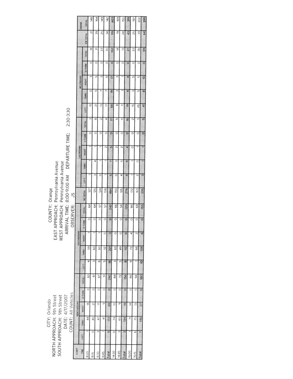
8 School Route Plan- Maxey Elementary School 5 Vehicular, Pedestrian, and Bicycle Volumes Two-hour turning movement counts were conducted at the intersections of Pennsylvania Avenue with 9 th Street and Bay Street with Bethune Avenue. The counts were conducted from 8:00 to 9:00 AM and 2:30 to 3:30 PM to coincide with the morning arrival time and afternoon departure time of students at the school. Pedestrian, bicycle, automobile, and bus traffic were recorded separately for this count. The following tables summarize the results of these counts: Table 2-Summary of Vehicular Volumes Approaches 9th Street at Pennsylvania Avenue 9th Street Pennsylvania Avenue Direction Northbound Southbound Eastbound Westbound Movement L T R TOT L T R TOT L T R TOT L T R TOT Morning Arrival: 800 to 900 Vehicles Busses Total Afternoon Departure: 1430 to 1530 Vehicles Busses Total Approaches Bethune Avenue at Bay Street Bethune Avenue Bay Street Direction Northbound Southbound Eastbound Westbound Movement L T R TOT L T R TOT L T R TOT L T R TOT Morning Arrival: 800 to 900 Vehicles Busses Total Afternoon Departure: 1430 to 1530 Vehicles Busses Total
9 School Route Plan- Maxey Elementary School 6 Table 3-Summary of Pedestrian & Bicycle Volumes Pennsylvania Avenue at 9 th Street Total 8:00 8:15 8:30 8:45 Total 2:30 2:45 3:00 3:15 AM PM Total AM PM 0 9th Street Total AM 3 Total AM 0 8: : : : : : : : AM PM Total 0 3 Pennsylvania Avenue Total AM PM 0 0 2: : : : : : : : Total PM 3 Total PM 0 9th Street Total 8:00 8:15 8:30 8:45 Total 2:30 2:45 3:00 3:15 AM PM Total AM PM 0 Pennsylvania Avenue Bay Street at Bethune Avenue Total 8:00 8:15 8:30 8:45 Total 2:30 2:45 3:00 3:15 AM PM AM 4 Bethune Avenue AM Total Total PM 0 Total AM 6 8: : : : : : : : AM PM Total 2 4 Bay Street Total AM PM : : : : : : : : Total PM 0 Total PM 4 Bethune Avenue Total 8:00 8:15 8:30 8:45 Total 2:30 2:45 3:00 3:15 AM PM Total AM PM 4 Bay Street
10 School Route Plan- Maxey Elementary School 7 3. QUALITATIVE ASSESSMENT Maxey Elementary School is located on East Maple Street, in Winter Garden. The school is located in an area of mixed use (light industrial, commercial, and residential) surrounding by a citrus grove on the west, automobile auction facility to the east, and light industrial/commercial to the north and south. The school serves children who live in adjacent surrounding neighborhoods including children south of West Colonial Drive (SR-50). Orange County currently provides bus service for children that live beyond the two-mile walk radius. Figure 2 illustrates the school zone boundaries, two-mile walk radius, and existing bus stops for Maxey Elementary School. Figure 3 is a School Route Plan map of the area within the two-mile walk limit where school bus service may or may not be provided. This area is the focus of the qualitative assessment. The school route plan area was reviewed by a registered professional engineer to evaluate vehicle, pedestrian, and bicycle flow patterns to determine what improvements are necessary, if any, to improve the safety and efficiency of the children traveling to and from school. General The school can only be accessed from East Maple Street. Buses and vehicles approach the school using East Maple Street (eastbound or westbound directions) and are required to enter the one-way semi-circle loop drive to access the drop off/pick up area on the north side of the school. After the field review it was determined that signs and striping are missing and some of the existing school warning signs do not meet current MUTCD standards. They are described in more detail below and should be added, replaced, or updated, as necessary. School Circulation Students arrive to school via bus, vehicles, walking, or bicycling. Bus service is provided for the residential areas surrounding the school. Buses and private vehicles use the semi-circle one-way loop drive to access the drop off/pick up area in the front of the school. Pedestrians use the sidewalk located on the south side (no sidewalk on north) of East Maple Street. There is not a crossing guard at the school. School staff uses a parking lot on the west side of the school. Parents and visitors also use this parking lot. There is also a small amount of street parking in the front (north) of the school adjacent to East Maple Street. This area appears to be used by parents who enter the school with their children. The sidewalk in front of the school is in need of various repairs to improve safety for pedestrians and bicyclists. It is recommended to repair the sidewalk on the south side of East Maple Street in front of the school. There are four buses used for drop off and four for pick up each day. There is also one head-start bus used in the morning drop off. During the morning drop off period, buses and vehicles enter the semi-circle drive and proceed past the main school entrance to an interior sidewalk about three-quarters around the semi-circle drive. In discussions with Billie Jean Daily, a staff person that works both drop off and pick up times, she explained that all students go to the cafeteria in the morning which is accessed from this sidewalk. Unloading students at this location provides more capacity in the semi-circle drive. The morning drop off circulation appeared to function efficiently. However, it was noticed that multiple students exited their vehicles from the driver s side (opposite side of school sidewalk) and
11 School Route Plan- Maxey Elementary School 8 walked between vehicles to enter the school. It is recommended to send a notice flyer to students/parents to discourage this unsafe activity and to only exit on the passenger side (sidewalk side) of the vehicle at drop off area. The afternoon pick up period uses the semi-circle drive as well. However, buses and vehicles pick up students at the main entrance which is half-way along the semi-circle drive. The afternoon traffic is more concentrated and uses less of the semi-circle drive resulting in less queuing capacity, thus vehicles backup onto East Maple Street (eastbound). The backup was observed along East Maple Street west of the staff parking entrance. In discussions with Billie Jean Daily and Jennifer Huttle, school staff assisting with student pick up, private vehicles are not allowed to enter the semi-circle drive in the afternoon until the buses have arrived and are parked at the pick up area. They said that parents generally follow this policy and rarely enter the semi-circle drive ahead of a bus. The backup on East Maple Street of eastbound traffic only lasted a few minutes and overall the carpool operations were safe and efficient. In discussions with Billie Jean Daily, she noted that vehicles regularly exceed the posted speed limit on East Maple Street in front of the school. She has also observed cars passing in this area. During the assessment an officer was observed using radar in front of the school to enforce speed in this area. It is recommended to continue using an officer to patrol this area during drop off/pick up times for speed enforcement and reckless driving. School Signage The existing school signage is shown in Figure 3 School Route Plan Map. Several deficiencies were discovered on East Maple Street approaching the school from the west and east. Multiple recommendations are shown below: On East Maple Street, east of the school, a flashing beacon should be installed on the existing School Speed Limit assembly. This sign is leaning significantly and should be straightened. There is currently a flashing beacon on the west side of the school on East Maple Street. On East Maple Street, a single lane pavement marking of SCHOOL should be striped on the east and west approaches of the school entrance. A School Advance Warning assembly with School Crossing Warning (S1-1) sign and an AHEAD (W16-9p) plaque should be installed. End School Zone sign shall be installed for both approaches to the school. Pennsylvania Avenue and 9 th Street The intersection of Pennsylvania Ave. and 9 th Street was observed during the morning and afternoon school hours. No crossing guards were present and the pedestrian and bicycle traffic was low. No students were observed using the crosswalk. The following observations were made:

12 9 N Maxey Elementary School 2 Mile Walk Zone Legend School Zone Boundary School School Bus Stop Traffic Signal Figure 2 School Boundary Map
13 YIELD YIELD YIELD 10 N YIELD Install Sign Assembly and School Pavement Marking 300 from AHEAD School Entrance WHEN FLASHING 20 SPEED LIMIT SCHOOL END SCHOOL ZONE 200 from Install Sign Assembly School Entrance Maxey Elementary Maxey Elementary School Legend G Crossing Guard School Bus Stops Pedestrian Route Bike Lane Crosswalk School Crossing Signalized Intersection Stop Sign Yield Sign Figure 3 1 of 2 School Route Plan Map
14 WHEN FLASHING YIELD SCHOOL SPEED LIMIT 20 Install Flashing Beacon and Align Sign Assembly 11 Install Sign Assembly END SCHOOL ZONE 200 from School Exit 300 from AHEAD School Exit Install Sign Assembly and School Pavement Marking N Maxey Elementary School Legend G Crossing Guard School Bus Stops Pedestrian Route Bike Lane Crosswalk School Crossing Signalized Intersection Stop Sign Yield Sign Figure 3 2 of 2 School Route Plan Map
15 School Route Plan- Maxey Elementary School 12 The markings are in poor condition at the intersection and the signs do not meet current MUTCD standards. Install crosswalk on the west approach, SCHOOL pavement markings for all approaches and restripe all existing pavement markings at the intersection. The School Crosswalk Warning assembly should be replaced with new (S1-1, W16-7p) signs. The School Advance Warning assembly should be updated with School Crossing Warning (S1-1) sign and AHEAD (W16-9p) plaques for north-south approaches and install a new School Advance Warning assembly for the east-west approaches. Concrete sidewalk shall be provided to connect E Story Road approximately 600 south. Pedestrian ramps shall be provided for the crosswalk on the south approach. Bay Street at Bethune Avenue The intersection of Bay Street and Bethune Ave was observed during the morning and afternoon school hours. No crossing guards were present and the pedestrian and bicycle traffic was low. Twenty two students used the crosswalk in the morning and seven students in the afternoon. The following observations were made: The markings are in poor condition at the intersection and the signs do not meet current MUTCD standards. Install crosswalk on the west and south approaches, restripe crosswalk on the east approach, SCHOOL pavement markings and the stop bars. The pedestrian crossing assembly should be replaced with School Crosswalk Warning assembly (S1-1, W16-7p). Also School Advance Warning assembly should be updated with School Crossing Warning (S1-1) sign and an AHEAD (W16-9p) plaque for east-west approaches and install a new School Advance Warning assembly for the north-south approaches. Provide pedestrian ramps for east approach and concrete sidewalk shall be provided on the southeast corner and between Bayou Road and Maxey Avenue. Figures 4 and 5 illustrate the existing intersections. Photographs of Pennsylvania Avenue with 9 th Street and Bay Street with Bethune Avenue are included in Exhibits 1 to 4.
16 9th Street 9th Street 300 from SCHOOL 13 crosswalk N SPEED LIMIT SPEED LIMIT 25 Pennsylvania Avenue Pennsylvania Avenue 23 Magnolia Street SCHOOL 280 from crosswalk Pennsylvania Avenue at 9th Street Figure 4 Condition Diagram
17 Bethune Avenue 14 Bayou Road Maxey Avenue N Bay Street AHEAD Bay Street AHEAD 20 Bay Street at Bethune Avenue Figure 5 Condition Diagram


18 School Route Plan- Maxey Elementary School 15 Exhibit 1- Pennsylvania Avenue at 9 th Street Looking west along Pennsylvania Avenue into 9 th Street Looking east along Pennsylvania Avenue into 9 th Street


19 School Route Plan- Maxey Elementary School 16 Exhibit 2- Pennsylvania Avenue at 9 th Street Looking south along 9 th Street into Pennsylvania Avenue Looking north along 9 th Street into Pennsylvania Avenue


20 School Route Plan- Maxey Elementary School 17 Exhibit 3- Bay Street at Bethune Avenue Looking west along Bay Street into Bethune Avenue Looking east along Bay Street into Bethune Avenue


21 School Route Plan- Maxey Elementary School 18 Exhibit 4- Bay Street at Bethune Avenue Looking south along Bayou Road into Bay Street Looking north along Bethune Avenue into Bay Street
22 School Route Plan- Maxey Elementary School RECOMMENDATIONS Based on the results of the analysis, field observations, and engineering judgment, the following recommendations and conclusions were developed: Signage: 1. On East Maple St, east of the school, a flashing beacon should be installed on the existing School Speed Limit assembly. This sign is leaning significantly and should be straightened. There is a flashing beacon on the west side of the school on East Maple St. 2. On East Maple Street, a single lane pavement marking of SCHOOL should be striped on the east & west approaches of the school entrance. A School Advance Warning assembly with School Crossing Warning (S1-1) sign and an AHEAD (W16-9p) plaque should be installed. End School Zone sign shall be installed for both approaches to the school. 3. At the Pennsylvania Avenue and 9th Street, the markings are in poor condition at the intersection and the signs do not meet current MUTCD standards. Install crosswalk on the west approach, SCHOOL pavement markings for all approaches and restripe all existing pavement markings at the intersection. The School Crosswalk Warning assembly should be replaced with new (S1-1, W16-7p) signs. The School Advance Warning assembly should be updated with School Crossing Warning (S1-1) sign and AHEAD (W16-9p) plaques for northsouth approaches and install a new School Advance Warning assembly for the east-west approaches. Concrete sidewalk shall be provided to connect E Story Road approximately 600 south. Pedestrian ramps shall be provided for the crosswalk on the south approach. 4. At the Bethune Avenue and Bay Street, the markings are in poor condition at the intersection and the signs do not meet current MUTCD standards. Install crosswalk on the west and south approaches, restripe crosswalk on the east approach, SCHOOL pavement markings and the stop bars. The pedestrian crossing assembly should be replaced with School Crosswalk Warning assembly (S1-1, W16-7p). Also School Advance Warning assembly should be updated with School Crossing Warning (S1-1) sign and an AHEAD (W16-9p) plaque for east-west approaches and install a new School Advance Warning assembly for the north-south approaches. Provide pedestrian ramps for east approach and concrete sidewalk shall be provided on the southeast corner and between Bayou Road and Maxey Avenue. Vehicle & Bus Operations: 5. Shared vehicle and bus operations occur in the semi-circle loop on the north side of the school. The operations appear to operate safely and efficiently for a shared operation. It was noted that some children exited on the driver s side (opposite to the curb) of the vehicle and were walking between vehicles. Recommend sending a notice flyer to students/parents reminding them to only exit vehicles on the passenger side (curb side) of the vehicle. Other Considerations: 6. It is recommended to repair the sidewalk on the south side of East Maple Street in front of the school. 7. It is recommended to continue using an officer to patrol this area during drop off/pick up times for speed enforcement and reckless driving. Figure 6 has been included on the following page to illustrate these recommendations. Also see Figure 3 for recommendations.
23 9th Street 9th Street Replace Sign Assembly and Restripe School Pavement Marking AHEAD 20 N SPEED LIMIT 25 Remove Sign SPEED LIMIT 35 Install Concrete Sidewalk to Connect Sidewalk on Maxey Ave Install Sign Assembly and Provide School Pavement Marking Install Crosswalk 250 from AHEAD stopbar Pennsylvania Avenue Pennsylvania Avenue Install Sign Assembly Restripe Crosswalk & Stop Bars and Install Pedestrian Ramps AHEAD 250 from crosswalk Install Sign Assembly and Provide School Pavement Marking Replace Sign Assembly 23 Install Concrete Sidewalk to Connect Sidewalk on E Storey Road approximately 600 south Replace Sign Assembly and Restripe School Pavement Marking Magnolia Street AHEAD Pennsylvania Avenue at 9th Street Figure 6 Conceptual Diagram 1 of 2
24 Bethune Avenue Install Sign Assembly and Provide School Pavement Marking AHEAD from stop bar Bayou Road Maxey Avenue N Install Sign Assembly Remove Crossing Signs and Restripe Crosswalk Install Concrete Sidewalk to Connect Sidewalk on Maxey Ave Replace Sign Assembly and Provide School Pavement Marking Bay Street Bay Street AHEAD 250 from crosswalk AHEAD 250 from crosswalk Replace Sign Assembly and Provide School Pavement Marking Install Concrete Sidewalk Install Sign Assembly, Stripe Crosswalk on West & South Approachs and Restripe Stop Bars from crosswalk AHEAD Install Sign Assembly and Provide School Pavement Marking Bay Street at Bethune Avenue Figure 6 Conceptual Diagram 2 of 2
25 School Route Plan- Maxey Elementary School APPENDIX
26
27
28
29
30
31
32
33
34
35
Meadow Woods Elementary School
 Drag and drop pic and stretch/crop to the limits of the blue rectangle (delete this text box) Meadow Woods Elementary School Drag and drop pic and stretch/crop to the limits of the blue rectangle (delete
Orange Center Elementary School
 Drag and drop pic and stretch/crop to the limits of the blue rectangle (delete this text box) Orange Center Elementary School Drag and drop pic and stretch/crop to the limits of the blue rectangle (delete
Hidden Oaks Elementary School
 Hidden Oaks Elementary School SCHOOL ROUTE PLAN For HIDDEN OAKS ELEMENTARY SCHOOL LOCATION 13 ORANGE COUNTY Prepared for: ORANGE COUNTY SCHOOL ASSESSMENT PROGRAM ORANGE COUNTY PUBLIC WORKS Traffic Engineering
Durrance Elementary School
 Durrance Elementary School SCHOOL ROUTE PLAN For DURRANCE ELEMENTARY SCHOOL LOCATION 9 ORANGE COUNTY Prepared for: ORANGE COUNTY SCHOOL ASSESSMENT PROGRAM ORANGE COUNTY PUBLIC WORKS Traffic Engineering
Windy Ridge Elementary School
 Windy Ridge Elementary School SCHOOL ROUTE PLAN For WINDY RIDGE ELEMENTARY SCHOOL LOCATION 54 ORANGE COUNTY Prepared for: ORANGE COUNTY SCHOOL ASSESSMENT PROGRAM ORANGE COUNTY PUBLIC WORKS Traffic Engineering
Lake Whitney Elementary School
 Lake Whitney Elementary School SCHOOL ROUTE PLAN For LAKE WHITNEY ELEMENTARY SCHOOL LOCATION 18 ORANGE COUNTY Prepared for: ORANGE COUNTY SCHOOL ASSESSMENT PROGRAM ORANGE COUNTY PUBLIC WORKS Traffic Engineering
SCHOOL ROUTE PLAN. For HUNTER S CREEK ELEMENTARY SCHOOL LOCATION 14 ORANGE COUNTY. Prepared for:
 SCHOOL ROUTE PLAN For HUNTER S CREEK ELEMENTARY SCHOOL LOCATION 14 ORANGE COUNTY Prepared for: ORANGE COUNTY SCHOOL ASSESSMENT PROGRAM ORANGE COUNTY PUBLIC WORKS Traffic Engineering Division 42 South John
July 5, Arthur R. Ware, Jr. Elementary School 2017 Safe Routes to School Walkabout Report
 July 5, 2017 Arthur R. Ware, Jr. Elementary School 2017 Safe Routes to School Walkabout Report 1 Walkabout Report Introduction On April 28, 2017, City, School, and SAWMPO staff met to conduct a Safe Routes
C/CAG. Sunnybrae Elementary School Walking and Bicycling Audit. San Mateo-Foster City School District JUNE 2013
 Sunnybrae Elementary School Walking and Bicycling Audit JUNE 2013 San Mateo-Foster City School District C/CAG City/County Association of Governments of San Mateo County SUNNYBRAE ELEMENTARY SCHOOL WALKING
SAFE ROUTES TO SCHOOL
 SAFE ROUTES TO SCHOOL Forest Ridge Elementary School Existing Conditions and ACTION PLAN > Oak Creek - Franklin Joint School District Table of Contents CONTEXT Enrollment Boundaries
TRAFFIC MANAGEMENT PLAN
 292 84 140440 TRAFFIC MANAGEMENT PLAN The purpose of the Traffic Management Plan (TMP) is to have established procedures for traffic flow and circulation around the elementary school related to student
AGENDA ITEM 6 D THOMASVILLE ROAD (HERMITAGE BOULEVARD TO LIVE OAK PLANTATION ROAD) ROADWAY SAFETY AUDIT
 ROADWAY SAFETY AUDIT") May 15, 2018 AGENDA ITEM 6 D THOMASVILLE ROAD (HERMITAGE BOULEVARD TO LIVE OAK PLANTATION ROAD) ROADWAY SAFETY AUDIT TYPE OF ITEM: Discussion STATEMENT OF ISSUE The Florida Department of Transportation
May 15, 2018 AGENDA ITEM 6 D THOMASVILLE ROAD (HERMITAGE BOULEVARD TO LIVE OAK PLANTATION ROAD) ROADWAY SAFETY AUDIT TYPE OF ITEM: Discussion STATEMENT OF ISSUE The Florida Department of Transportation
Traffic Circulation & Pedestrian Safety Study
 Lyons Township High School North Campus La Grange, Illinois Parking Lot Vaughan Building N Main Building Prepared for: Prepared by: July 23, 2015 Contents List of Figures, iii 1. Introduction...1 2. Existing
Military Road Safety Improvements
 Military Road Safety Improvements 26 th Road North to 31 st Street North SUMMARY OF DATA REVIEW AND PRELIMINARY RECOMMENDATIONS Prepared for: Department of Environmental Services Traffic Engineering and
Sebastopol Charter School Traffic Management Plan
 Sebastopol Charter School The serves as the working document in support of these essential goals: to ensure the safety and efficiency of student arrival to and departure from school to ensure the safety
Date: April 4, Project #: Re: A Street/Binford Street Traffic/Intersection Assessment
 To: Peter Cavanaugh General Electric From: David Bohn, PE Ryan White, PE Date: April 4, 217 Project #: 13421. Re: / Traffic/Intersection Assessment Consistent with the Cooperation Agreement between the
Memorandum. Sunday, July 13, Saturday, July 19, 2014
 Memorandum To: David Lowin, Brooklyn Bridge Park Corporation From: Daniel Schack, AICP, PTP Date: Re: Brooklyn Bridge Park Pier 5/6 Loop Road Traffic Study Project No: 14-01-2407 At the request of Brooklyn
Walkabout Summary Report
 Walkabout Summary Report Introduction On September 3, 2014, stakeholders at Bessie Weller Elementary School (Bessie Weller ES) in Staunton, Virginia met to examine the walking and bicycling network around
Niantic Center Elementary School
 Niantic Elementary School is located in the Northwest corner of the intersection of West Main Street and East Pattagansett Road, as so noted on the Facility Location Map. location Overview: The site is
Summary: Mercer County Princeton Avenue & Spruce Street Study January 2009
 Summary: Several recent studies have assessed potential development and redevelopment opportunities in the Mercer Crossing area of Trenton, Ewing, and Lawrence. This Princeton Avenue and Spruce Street
PEDESTRIAN SAFETY STUDY
 PEDESTRIAN SAFETY STUDY SR 699 (BLIND PASS RD/GULF BLVD) FROM 93 RD AVENUE TO PINELLAS BAYWAY PINELLAS COUNTY SECTION NO.: 15100 MILEPOST: 0.111 3.569 STUDY LIMITS Prepared For: Florida Department of Transportation
Introduction Additional Safe Routes to School Resources Main Street Elementary School Survey Results Field Audit...
 Contents Introduction... 2 Additional Safe Routes to School Resources... 2... 3 Survey Results... 4 Field Audit... 6 Proposed Safe Routes to School Elements... 9 Typical Safe Routes to School Summary...
TRAFFIC ACTION PLAN. Laurie Meadows Neighborhood CITY OF SAN MATEO
 TRAFFIC ACTION PLAN Laurie Meadows Neighborhood CITY OF SAN MATEO Draft January 2017 Table of Contents Introduction... 2 The Traffic Forum Process... 5 Neighborhood Traffic Issues... 7 Neighborhood Recommendations
Transportation Impact Study for Abington Terrace
 Transportation Impact Study for Abington Terrace Abington Township, Montgomery County, PA Sandy A. Koza, P.E., PTOE PA PE License Number PE059911 Prepared by McMahon Associates, Inc. 425 Commerce Drive,
DEPARTMENT OF ENVIRONMENTAL SERVICES. North Harrison Street (Lee Highway to Little Falls Road) Comparative Analysis. Prepared for:
 Comparative Analysis. Prepared for:") DEPARTMENT OF ENVIRONMENTAL SERVICES North Harrison Street (Lee Highway to Little Falls Road) Comparative Analysis Prepared for: Arlington County Department of Environmental Services 2100 Clarendon Boulevard,
DEPARTMENT OF ENVIRONMENTAL SERVICES North Harrison Street (Lee Highway to Little Falls Road) Comparative Analysis Prepared for: Arlington County Department of Environmental Services 2100 Clarendon Boulevard,
Implementing the Three Es of School Zone Traffic Calming
 Implementing the Three Es of School Zone Traffic Calming Use this evaluation tool as a guide to analyze the specific safety needs of your school. SCHOOL PROFILE School Name: School District: Address: Phone
Waterford Lakes Small Area Study
 Waterford Lakes Small Area Study Existing Traffic Conditions PREPARED FOR: ORANGE COUNTY PUBLIC WORKS DEPARTMENT TRAFFIC ENGINEERING DIVISION ORLANDO, FLORIDA PREPARED WITH: INWOOD CONSULTING ENGINEERS
Chicago Safe Routes to School Safe Routes to High School (SRTS/SRTHS)
") Chicago Safe Routes to School Safe Routes to High School (SRTS/SRTHS) Marshall Community High School and Faraday Elementary School Recommended Improvements Agenda Goals Related Programs Project Location/Area
Chicago Safe Routes to School Safe Routes to High School (SRTS/SRTHS) Marshall Community High School and Faraday Elementary School Recommended Improvements Agenda Goals Related Programs Project Location/Area
HALFF TRAFFIC MANAGEMENT PLAN. Richardson ISD Northwood Hills Elementary School Dallas, Texas. /? /4O/2o16
 30279 161966 TRAFFIC MANAGEMENT PLAN Richardson ISD Northwood Hills Elementary School August 30 2016 Exhibit 976B Planned Development District No. 976 Z156-311(OTH) Approved City Plan Commission October
SAFE ROUTES TO SCHOOL
 SAFE ROUTES TO SCHOOL Edgewood Elementary School Existing Conditions and ACTION PLAN > Oak Creek - Franklin Joint School District Table of Contents CONTEXT Enrollment Boundaries Enrollment
LTAC: Katie Mencarini, Central & Hampton Roads streets and a fifteen minute debrief to discuss the findings. Participants walked along Mill Road
 Walkabout Summary On June 3, 2013, five participants met at Glen Allen Elementary School in Glen Allen, Virginia to take a closer look at the walking and biking network around the school. In addition to
Chapter 4.3 Enterprise Elementary. Volusia County MPO. March Page 7.0
 Chapter 4.3 Enterprise Elementary Enterprise, FL Volusia County MPO March 2008 Page 7.0 Volusia County MPO Bicycle and Pedestrian School Safety Review Study Introduction Enterprise Elementary School is
Chapter 3.9 Timbercrest Elementary School. Volusia County MPO. November 2008
 Chapter 3.9 Timbercrest Elementary School Deltona, FL Volusia County MPO November 2008 Volusia County MPO School Bicycle and Pedestrian Review Study, Phase 3B School Summary Timbercrest Elementary School
Forest Hills Improvement Initiative
 Forest Hills Improvement Initiative Transportation Action Plan Short Term Recommendations ONLY Final Draft as of April 30, 2008 For Community Review and Feedback Prepared for: The City of Boston Boston
CAPITOL DRIVE & FOND DU LAC AVENUE INTERSECTION ANALYSIS. Urban Planning 772 SARAH BREGANT, RYAN PETERSON, & MATT WERDERITCH
 CAPITOL DRIVE & FOND DU LAC AVENUE INTERSECTION ANALYSIS Urban Planning 772 SARAH BREGANT, RYAN PETERSON, & MATT WERDERITCH OVERVIEW N 51 ST BOULEVARD N 51 ST BOULEVARD 12,100 44,700 W CAPITOL DRIVE 52,600
Multi-Modal Traffic Analysis. Parisi and Associates
 Mill Valley to Corte Madera Bicycle and Pedestrian Corridor Study Appendix D: Multi-Modal Traffic Analysis Prepared by Parisi and Associates August 2009 Appendix D - Multi-Modal Traffic Analysis Table
Ottawa Beach Road Study
 Ottawa Beach Road Study Prepared For: Park Township September 30, 2014 Project No. G140303 OTTAWA BEACH ROAD STUDY PREPARED FOR: PARK TOWNSHIP SEPTEMBER 30, 2014 PROJECT NO. G140303 TABLE OF CONTENTS 1.0
DRAFT Davidson Elementary School Expansion Transportation Impact Analysis
 DRAFT Davidson Elementary School Expansion Transportation Impact Analysis Prepared for: Town of Davidson 216 S. Main Street Davidson, NC 28036 Prepared by: Stantec Consulting Services Inc. 2127 Ayrsley
Corporate. Report COUNCIL DATE: May 25, 1998 NO: R1500 REGULAR COUNCIL. TO: Mayor & Council DATE: April 27, 1998
 R1500 : Traffic Safety at 25 Avenue and 128 Street Intersection Corporate NO: R1500 Report COUNCIL DATE: May 25, 1998 REGULAR COUNCIL TO: Mayor & Council DATE: April 27, 1998 FROM: General Manager, Engineering
Bremen Elementary. SAFE ROUTES TO SCHOOL TRAVEL PLAN October 9, 2012
 Bremen Elementary SAFE ROUTES TO SCHOOL TRAVEL PLAN October 9, 2012 Introduction The purpose of the Bremen Elementary Safe Route to School (SRTS) Plan is to encourage school age children to travel to school
F L E T C H E R A V E N U E
 Jan. 29, 2014 Introduction F L E T C H E R A V E N U E FDOT Local Agency Program (LAP) Project FPN: 428214-1-58-01 CIP 63090 Hillsborough County, Traffic Engineering, PWD Stake holders and partners are
Table 1 Traffic and Pedestrian Counts on Lafayette Street
 Downtown Salem Transportation Study 2 July 8, 2005 On-street parking is allowed on both sides of Lafayette Street. Cars were parked at the island that separates a pull-out area in front of the school entrance
INDUSTRIAL BUILDING 1660 COMSTOCK ROAD CITY OF OTTAWA TRANSPORTATION OVERVIEW. Prepared for:
 INDUSTRIAL BUILDING 1660 COMSTOCK ROAD CITY OF OTTAWA TRANSPORTATION OVERVIEW Prepared for: Simluc Contractors Limited 2550 Blackwell Street, Ottawa K1B 5R1 October 18, 2013 113-584 Overview_1.doc D. J.
Draft North Industrial Area-Wide Traffic Plan
 Summary of North Industrial and Hudson Bay Industrial Recommended Improvements Table 1. Summary of s Item Location 1 2 3 4 5 6 7 8 9 10 11 12 Millar Ave north of 51st St Super 8 Motel back lane 400 Block
ATTACHMENT NO. 11. RRLRT No. 2. Railroad / Light Rail Transit Technical Committee TECHNICAL COMMITTEE: Busway Grade Crossings STATUS/DATE OF ACTION
 ATTACHMENT NO. 11 RRLRT No. 2 TECHNICAL COMMITTEE: TOPIC: Railroad / Light Rail Transit Technical Committee Busway Grade Crossings STATUS/DATE OF ACTION RRLRT TC Draft: 06/23/2011 RRLRT TC Approval: 06/27/2014
TRAFFIC ACTION PLAN. Central Neighborhood CITY OF SAN MATEO
 TRAFFIC ACTION PLAN Central Neighborhood CITY OF SAN MATEO Draft January 2017 Table of Contents Introduction... 1 The Traffic Forum Process... 4 Neighborhood Traffic Issues... 7 Neighborhood Recommendations
TRAFFIC IMPACT STUDY And A TRAFFIC SIGNAL WARRANT ANALYSIS FOR A SENIOR LIVING AND APARTMENT DEVELOPMENT
 TRAFFIC IMPACT STUDY And A TRAFFIC SIGNAL WARRANT ANALYSIS FOR A SENIOR LIVING AND APARTMENT DEVELOPMENT DEERFIELD TOWNSHIP, WARREN COUNTY, OHIO Nantucket Circle and Montgomery Road () Prepared for: ODLE
Glenn Avenue Corridor Traffic Operational Evaluation
 Glenn Avenue Corridor Traffic Operational Evaluation PREPARED FOR: THE CITY OF AUBURN PREPARED BY: DECEMBER 2007 Glenn Avenue Corridor Study--Auburn, Alabama TABLE OF CONTENTS Introduction... 1 Background
Oregon Supplement to the Manual on Uniform Traffic Control Devices. Adopted July 2005 by OAR
 Oregon Supplement to the Manual on Uniform Traffic Control Devices Adopted July 2005 by OAR 734-020-0005 2003 Edition Oregon Supplement to the MUTCD Page 2 INTRODUCTION Traffic control devices installed
Safe Routes to School Comprehensive Plan
 Safe Routes to School Comprehensive Plan City of Apple Valley Dakota County, MN May 2010 Prepared by: Project Background The Statewide Health Improvement Program (SHIP) aims to help Minnesotans live longer,
Chapter 3.6 Elementary School Z. Volusia County MPO. March Page 13.0
 Chapter 3.6 Elementary School Z DeLand, FL Volusia County MPO March 2008 Page 13.0 Volusia County MPO Bicycle and Pedestrian School Safety Review Study Introduction Elementary School Z is a planned elementary
Final Sidewalk Feasibility Study
 Garfield Drive From Anastasia Drive to Elizabeth Place City of South Daytona July 23, 2009 Final Sidewalk Feasibility Study Prepared for: Prepared by: Final Sidewalk Feasibility Study Garfield Drive 2
HENDERSON DEVELOPMENT 213, 217, 221, 221 ½, 223 HENDERSON AVENUE and 65 TEMPLETON STREET OTTAWA, ONTARIO TRANSPORTATION OVERVIEW.
 HENDERSON DEVELOPMENT 213, 217, 221, 221 ½, 223 HENDERSON AVENUE and 65 TEMPLETON STREET OTTAWA, ONTARIO TRANSPORTATION OVERVIEW Prepared for: 2294170 Ontario Inc. February 2, 2017 117-652 Report_1.doc
TRAFFIC IMPACT ANALYSIS
 TRAFFIC IMPACT ANALYSIS FOR THE CHAMPAIGN UNIT#4 SCHOOL DISTRICT PROPOSED HIGH SCHOOL (SPALDING PARK SITE) IN THE CITY OF CHAMPAIGN Final Report Champaign Urbana Urbanized Area Transportation Study 6/24/2014
Traffic Impact Study. Westlake Elementary School Westlake, Ohio. TMS Engineers, Inc. June 5, 2017
 TMS Engineers, Inc. Traffic Impact Study Westlake Elementary School Westlake, Ohio June 5, 2017 Prepared for: Westlake City Schools - Board of Education 27200 Hilliard Boulevard Westlake, OH 44145 TRAFFIC
ROUNDABOUTS/TRAFFIC CIRCLES
 GENERAL 1. Description This standard identifies minimum requirements that shall be met for Roundabouts and Neighborhood Traffic Circles in the design and construction of elements for Arlington County Horizontal
Duwamish Way-finding and CTR Report
 V. North Tukwila When the North Tukwila Manufacturing and Industrial Center was designated in 1992 as part of the region s land use and transportation plan, the plan called for the area to set a light-rail
5. MODIFICATIONS AT JEANNE D ARC BOULEVARD/REGIONAL ROAD 174 INTERCHANGE INTERSECTION - PUBLIC HEARING COMMITTEE RECOMMENDATION
 5. MODIFICATIONS AT JEANNE D ARC BOULEVARD/REGIONAL ROAD 174 INTERCHANGE INTERSECTION - PUBLIC HEARING COMMITTEE RECOMMENDATION Having held a public hearing, that Council approve the preliminary designs
IMPLEMENTATION WORKBOOK
 Lawrence Township Bicycle and Pedestrian Planning Assistance Study IMPLEMENTATION WORKBOOK Final Action Plan - Part 2 April 2009 Prepared For: The Township of Lawrence and the New Jersey Department of
Appendix A. Knoxville TPO Greenway Signage Guidelines. Appendix A: Knoxville TPO Greenway Signage Guidelines Knox to Oak Ridge Greenway Master Plan
 Appendix A Knoxville TPO Greenway Signage Guidelines 75 Overview: Adequate signing and marking are essential on shared-use paths, especially to alert bicyclists to potential conflicts and to convey regulatory
COMMUNITY MEETING AGENDA
 COMMUNITY MEETING AGENDA Welcome and Introductions SAFE Presentation Project Presentation Priorities Feedback Next Steps Q&A Santa Cruz Avenue Corridor Study 1 Santa Cruz Avenue Corridor Study Community
CITY OF OAK CREEK SAFE ROUTES TO SCHOOL ACTION PLAN. East Middle School
 CITY OF OAK CREEK SAFE ROUTES TO SCHOOL ACTION PLAN East Middle School CITY OF OAK CREEK SAFE ROUTES TO SCHOOL ACTION PLAN East Middle School Why Safe Routes to School? Safe Routes to School ( SRTS ) is
Complete Streets Funding Program Project Prioritization Plan
 Funding Program Project Prioritization Plan Location and Type Needs South Street Crosswalk Installation Stripe a new formalized crosswalk across South Street at the Anne T. Dunphy School pedestrian path
Princeton Avenue and Spruce Street Transportation and Site Access Enhancements Project
 Princeton Avenue and Spruce Street Transportation and Site Access Enhancements Project Mercer County Planning Division AECOM Transportation (formerly DMJM Harris) January 29, 2009 Agenda Project Status
4. ENVIRONMENTAL IMPACT ANALYSIS 9. TRANSPORTATION AND TRAFFIC
 4. ENVIRONMENTAL IMPACT ANALYSIS 9. TRANSPORTATION AND TRAFFIC 4.9.1 INTRODUCTION The following section addresses the Proposed Project s impact on transportation and traffic based on the Traffic Study
PART 7. TRAFFIC CONTROLS FOR SCHOOL AREAS CHAPTER 7A. GENERAL
 2012 Edition Page 825 Section 7A.01 Need for Standards January 13, 2012 PART 7. TRAFFIC CONTROLS FOR SCHOOL AREAS CHAPTER 7A. GENERAL 01 Regardless of the school location, the best way to achieve effective
APS Stratford Project Transportation Analysis Overview. Stratford BLPC #5 June 1, 2015
 APS Stratford Project Transportation Analysis Overview Stratford BLPC #5 June 1, 2015 8 Arrival/dismissal observations and counts BLPC arrival/dismissal observations BLPC early release observation Williamsburg
ORANGE COUNTY PUBLIC WORKS TRAFFIC INVESTIGATIONS
 ORANGE COUNTY PUBLIC WORKS TRAFFIC INVESTIGATIONS STAFF REPORT OF: January 6, 2019 SUPERVISORIAL DISTRICT: 5 SUBJECT: LOCATION: INVESTIGATOR: O Neill Drive at Roanoke Drive; Ladera Ranch; TB 922-E6 Clever
Roundabout Evaluations in Virginia: US 15/US 50 Gilberts Corner, VA SR 106/SR 634 Prince George County, VA
 Roundabout Evaluations in Virginia: US 15/US 50 Gilberts Corner, VA SR 106/SR 634 Prince George County, VA VDOT & FHWA Roundabout Workshop September 17, 2013 Chris Tiesler, PE Presentation Outline US 15/US
2009 Manual on Uniform Traffic Control Devices
 2009 Manual on Uniform Traffic Control Devices Tori Brinkly, PE Highway Safety Engineer WFL-FHWA April 20, 2010 Paragraphs are numbered. Standard Statements are bolded. Guidance statements are italicized.
TOWN OF CHAPEL HILL POLICY AND PROCEDURES FOR TRAFFIC CALMING MEASURES
 TOWN OF CHAPEL HILL POLICY AND PROCEDURES FOR TRAFFIC CALMING MEASURES (Adopted by the Town Council on June 30, 2004) (Revised December 6, 2010) (Revised February 8, 2016) POLICY AND PROCEDURES FOR TRAFFIC
Markings Technical Committee Chapter 3H: Roundabout Markings APPROVED IN NCUTCD COUNCIL ON JANUARY 20, 2006
 ATTACHMENT NO. 30 Markings Technical Committee Chapter 3H: Roundabout Markings APPROVED IN NCUTCD COUNCIL ON JANUARY 20, 2006 Roundabouts are becoming an increasingly utilized form of intersection design
City of Albert Lea Policy and Procedure Manual 4.10 ALBERT LEA CROSSWALK POLICY
 4.10 ALBERT LEA CROSSWALK POLICY PURPOSE: Pedestrian crosswalks are an integral part of our transportation infrastructure. To be effective and promote safety, marked crosswalks must be installed after
Guidance. ATTACHMENT F: Draft Additional Pages for Bicycle Facility Design Toolkit Separated Bike Lanes: Two-Way to One-Way Transitions
 ATTACHMENT F: Draft Additional Pages for Bicycle Facility Design Toolkit Separated Bike Lanes: Two-Way to One-Way Transitions This treatment provides a transition from two-way separated bike lanes to one-way
Highland Park High School Campus Traffic and Parking Study
 Highland Park High School Campus Traffic and Parking Study February 24, 2015 Eriksson Engineering Associates, Ltd. Prepared for: Township High School District 113 Eriksson Engineering Associates, Ltd.
FLORIDA DEPARTMENT OF TRANSPORTATION DISTRICT 7 DISTRICT WIDE BICYCLE/PEDESTRIAN ACCESS TO TRANSIT SAFETY ASSESSMENT AND IMPROVEMENT PLAN
 FLORIDA DEPARTMENT OF TRANSPORTATION DISTRICT 7 DISTRICT WIDE BICYCLE/PEDESTRIAN ACCESS TO TRANSIT SAFETY ASSESSMENT AND IMPROVEMENT PLAN TRANSIT SAFETY ASSESSMENT SR 55/US 19 AT 80 TH AVE N DRAFT JUNE
Bicycle and Pedestrian Facilities Toolbox (Excerpt from Figure 3.1)
") Appendix B Neighborhood Connections Summaries This Appendix is a supplement to the information presented in Chapter 3 Connect People. The Appendix includes a summary or profile for each of the proposed
Appendix B Neighborhood Connections Summaries This Appendix is a supplement to the information presented in Chapter 3 Connect People. The Appendix includes a summary or profile for each of the proposed
Chapter 3.5 Osteen Elementary School. Volusia County MPO. November 2008
 Chapter 3.5 Osteen Elementary School Osteen, FL Volusia County MPO November 2008 Volusia County MPO School Bicycle and Pedestrian Review Study, Phase 3B School Summary Osteen Elementary School is located
Complete Street Analysis of a Road Diet: Orange Grove Boulevard, Pasadena, CA
 Complete Street Analysis of a Road Diet: Orange Grove Boulevard, Pasadena, CA Aaron Elias, Bill Cisco Abstract As part of evaluating the feasibility of a road diet on Orange Grove Boulevard in Pasadena,
ORANGE COUNTY TRAFFIC COMMITTEE. Intersection Control. Constituent. Deepthi Arabolu. Relocate Stop Sign
 ORANGE COUNTY TRAFFIC COMMITTEE SUPERVISORIAL DISTRICT: 3 SUBJECT: Intersection Control LOCATION: Browning Avenue at Rainbow Drive; North Tustin; TB 830-E3 INITIATED BY: INVESTIGATOR: REQUEST: Constituent
Updated There is no park access points beyond the limit of the phase I work. roadway to be constructed Viewport has been along full limits of the park
 The signs will be installed as Temporary signs the color (Orange/White) have been added to the plans. Need to specify color to be used for stripes. Closures that may be in place for extended periods need
Chapter 3.3 Horizon Elementary School. Volusia County MPO. June 2009
 Chapter 3.3 Horizon Elementary School Port Orange, FL Volusia County MPO June 2009 Volusia County MPO School Bicycle and Pedestrian Review Study, Phase 3C School Summary Horizon Elementary School is located
Arlington Public Schools Thomas Jefferson Site Evaluation Transportation Networks. Thomas Jefferson Working Group Meeting #6 November 10, 2014
 Arlington Public Schools Thomas Jefferson Site Evaluation Transportation Networks Thomas Jefferson Working Group Meeting #6 November 10, 2014 2 3 INTRODUCTION 4 Goal of our work: Identify and assess multi-modal
San Rafael School District. Task Force Meeting Notes. November 5, 2012
 San Rafael School District Task Force Meeting Notes November 5, 2012 Attendees (8) Wendi Kallins Program Director for Safe Routes to Schools; Laura Kelly Volunteer Liaison for Safe Routes to Schools; Leslie
Improving Cyclist Safety at the Dundas Street West and Sterling Road Intersection
 STAFF REPORT ACTION REQUIRED Improving Cyclist Safety at the Dundas Street West and Sterling Road Intersection Date: August 17, 2012 To: From: Wards: Reference Number: Public Works and Infrastructure Committee
MEMORANDUM. Charlotte Fleetwood, Transportation Planner
 MEMORANDUM Date: Updated August 22, 2017 To: Organization: Charlotte Fleetwood, Transportation Planner Boston Transportation Department From: Jason DeGray, P.E., PTOE, Regional Director of Engineering
Unit Five : Driving In Neighborhoods
 Unit Five : Driving In Neighborhoods What Are We Going To Do Today? Students will be able to describe the skills necessary to How safely and do legally you make drive in a residential How do area. you
Arlington Public Schools New Elementary School at Thomas Jefferson Site Off-Site Transportation. Thomas Jefferson BLPC / PFRC Meeting July 27, 2016
 Arlington Public Schools New Elementary School at Thomas Jefferson Site Off-Site Transportation Thomas Jefferson BLPC / PFRC Meeting July 27, 2016 1.Review of Analysis 2.Key Transportation Issues 3.Recommendations
Traffic Signal Phasing Study Summary & Staff Recommendations
 Traffic Signal Phasing Study Summary & Staff Recommendations Consultant Study by Skipper Consulting, Inc. Staff Committee Recommendations by Randy Pewitt, Executive Director of Emergency Mgt. and Safety
City of Prince Albert Statement of POLICY and PROCEDURE. Department: Public Works Policy No. 66. Section: Transportation Issued: July 14, 2014
 Page: 1 of 8 1 POLICY 1.01 The City shall follow all of the specifications in the Manual of Uniform Traffic Control Devices for Canada, prepared by the National Committee of Uniform Traffic Control, and
Dr. M.L. King, Jr. Street North Complete Streets Resurfacing Opportunities HOUSING, LAND USE, AND TRANSPORTATION COMMITTEE MARCH 22, 2018
 Dr. M.L. King, Jr. Street North Complete Streets Resurfacing Opportunities HOUSING, LAND USE, AND TRANSPORTATION COMMITTEE MARCH 22, 2018 What s Happening The City plans to mill and resurface Dr. M.L.
2007 TRAFFIC SIGNAL PRIORITY LIST SUMMARY OF STAFF RECOMMENDATIONS TO PEDESTRIAN/BICYCLE/MOTOR VEHICLE COMMISSION.
 Traffic Engineering and Parking Divisions David C. Dryer, City Traffic Engineer and Parking Manager 215 Martin Luther King, Jr. Boulevard P.O. Box 2986 Madison, Wisconsin 53701-2986 Phone 608 266 4761
TRAFFIC MANAGEMENT PLAN
 April 19, 018 PK# 415-17.387 TRAFFIC MANAGEMENT PLAN Project: In Dallas, Texas Prepared for: City of Dallas On behalf of: Dallas Independent School District Prepared by: Hunter W. Lemley, P.E. 7557 Rambler
Vallecito Elementary School. Travel Plan
 Vallecito Elementary School Travel Plan TABLE OF CONTENTS 1. PURPOSE... 1 1.1. SR2S PLANNING, IMPLEMENTATION AND MONITORING... 1 1.2. MARIN COUNTY MEASURE A... 1 2. VALLECITO ELEMENTARY SCHOOL PROFILE...
Vehicular and Pedestrian Access to Herndon Metrorail Station. Robert B. Boxer, Director John Stuart, Clark Nexen October 28, 2015
 Vehicular and Pedestrian Access to Herndon Metrorail Station Robert B. Boxer, Director John Stuart, Clark Nexen Project Location The project is located in the Town of Herndon along Herndon Parkway between
Waterford Lakes Small Area Study Report
 Waterford Lakes Small Area Study Report Orange County District 4 Prepared for: Orange County Public Works Department Traffic Engineering Division 4200 S. John Young Parkway Orlando, FL 32839-9205 Prepared
Appendix D Revised Transportation Impact Analysis. Heffron Transportation, Inc. May 2008
 Appendix D Revised Transportation Impact Analysis Heffron Transportation, Inc. May 2008 TECHNICAL MEMORANDUM Project: Subject: Denny Middle School and Chief Sealth High School Redevelopment Date: May
CITY OF WEST LAKE HILLS. Forest View Neighborhood Traffic Calming Study
 CITY OF WEST LAKE HILLS 901 South Mopac Expressway Building V, Suite 220 Austin, Texas 78746 Texas P.E. Firm Registration No. F-929 Klotz Associates Final Report Submittal: March 20, 2015 Revised Final
MEMORANDUM. Discussion of the planned crosswalk improvement on Mount Vernon Road near Stratham Drive
 MEMORANDUM To: From: Mayor and City Council Michael Smith, Public Works Director Date: August 24, 2015 Subject: Discussion of the Mount Vernon Road Crosswalk Improvement ITEM DESCRIPTION Discussion of
Appendix C. TRAFFIC CALMING PROGRAM TOOLBOX
 Appendix C. TRAFFIC CALMING PROGRAM TOOLBOX PHASE I...2 Do Not Enter Sign...3 One-Way Sign...4 Turn Prohibition...5 Pavement Markings...6 Speed Monitoring Trailer...7 Neighborhood Speed Watch...8 Police