FLORIDA DEPARTMENT OF TRANSPORTATION DISTRICT 7 DISTRICT WIDE BICYCLE/PEDESTRIAN ACCESS TO TRANSIT SAFETY ASSESSMENT AND IMPROVEMENT PLAN
|
|
|
- Alfred Booth
- 5 years ago
- Views:
Transcription


1 FLORIDA DEPARTMENT OF TRANSPORTATION DISTRICT 7 DISTRICT WIDE BICYCLE/PEDESTRIAN ACCESS TO TRANSIT SAFETY ASSESSMENT AND IMPROVEMENT PLAN TRANSIT SAFETY ASSESSMENT SR 55/US 19 AT 80 TH AVE N DRAFT JUNE 2016
2 DISTRICT WIDE BICYCLE/PEDESTRIAN ACCESS TO TRANSIT SAFETY ASSESSMENT AND IMPROVEMENT PLAN Introduction The Florida Department of Transportation (FDOT) District 7 (D7), through the District Wide Bicycle/Pedestrian Access to Transit Safety Assessment and Improvement Plan contract, has identified the following as principal objectives to enhance pedestrian and bicycle mobility and access to transit: Promote regional safety for bicycle and pedestrian activity on road/transit throughways and corridors. Institutionalize enhancement and practices to create a safe, comfortable, accessible, and welcoming bicycle/pedestrian environment. Encourage multimodal activity to generate economic vitality throughout the entire region. To aid in the achievement of these objectives, a process to identify and assess locations with potential safety concerns has been developed and is being implemented. The identification of locations is largely based on quantitative inputs including average weekday stop level transit ridership data and historic (five year) pedestrian and bicycle crash data. Qualitative inputs from local stakeholders (e.g., local transit agencies and/or local jurisdictions) are also included in the process. The following section describes the process that has been implemented to assess the identified locations. Transit Safety Assessment The Federal Highway Administration s (FHWA) Safety Office established the Road Safety Audit (RSA) as a way to improve the overall safety performance of roadways. An RSA is a comprehensive formal safety performance evaluation of an existing or future roadway segment or intersection performed by an independent and multidisciplinary team. RSAs are viewed as a low cost proactive approach to safety that considers all road users and identifies opportunities to enhance safety and reduce the number and severity of crashes. FHWA states that the goal of an RSA is to answer the following questions: What elements of the road may present a safety concern: to what extent, to which road users, and under what circumstances? What opportunities exist to eliminate or mitigate identified safety concerns? Using the RSA model, the Transit Safety Assessment (TSA) was developed to provide a qualitative assessment of potential safety issues and identify opportunities for safety improvements that focus primarily on enhancing pedestrian and bicycle mobility and access to transit while also identifying potential enhancements to overall traffic/transit operations. SR55/US 19 AT 80TH AVE N DRAFT JUNE

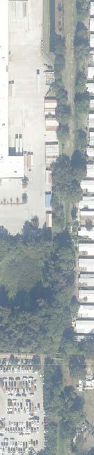
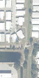
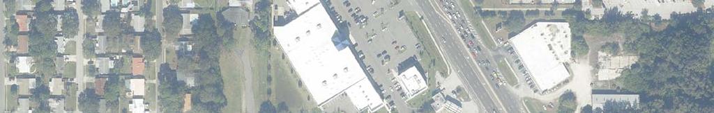
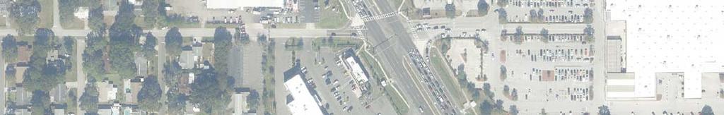
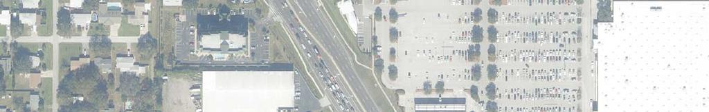
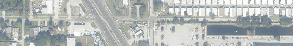
3 FLORIDA DEPARTMENT OF TRANSPORTATION DISTRICT 7 Study Area The intersection of US 19 (SR 55) and 80 th Ave N is located in Pinellas Park in Pinellas County. US 19 is a State maintained arterial highway that serves both local and regional traffic through northern Pinellas County. 80 th Ave N is a local road that dead ends at the Walmart parking lot on the east side of US 19. The land use mix along US 19 is primarily a mix of commercial (retail/service), office, and some industrial uses directly adjacent to the roadway. There are a significant amount of residential uses behind the various uses fronting US 19. Figure 1 on the following page shows the general area around the intersection of US 19 and 80th Ave N. Intersection of US 19 and 80 th Ave N 2 DRAFT JUNE 2016 TRANSIT SAFETY ASSESSMENT

4 DISTRICT WIDE BICYCLE/PEDESTRIAN ACCESS TO TRANSIT SAFETY ASSESSMENT AND IMPROVEMENT PLAN Figure 1: Transit Safety Assessment review area SR55/US 19 AT 80TH AVE N DRAFT JUNE

5 FLORIDA DEPARTMENT OF TRANSPORTATION DISTRICT 7 Traffic Data At the intersection of US 19, 80 th Avenue N is a 2 lane local roadway and US 19 is a 6 lane State highway with a raised partially landscaped median, as shown below. Using the most recent available data from the FDOT Florida Traffic Online tool, the Annual Average Daily Traffic (AADT) for US 19 was north of Park/Gandy Blvd and was reported as 46,500, as shown in Figure 3. Source: Florida Traffic Online, Historical AADT Report Figure 3: Historical AADT, US 19 north of Park/Gandy Blvd Intersection lane alignment diagram 4 DRAFT JUNE 2016 TRANSIT SAFETY ASSESSMENT


6 DISTRICT WIDE BICYCLE/PEDESTRIAN ACCESS TO TRANSIT SAFETY ASSESSMENT AND IMPROVEMENT PLAN Transit Service Pinellas Suncoast Transit Authority (PSTA) Route 19 runs north south and serves the intersection of 80 th Ave N and US 19 on US 19. Route 444 also serves US 19 in this area as well as 78 th Ave N to the west of US 19. There are eight bus stops within the reviewed area. According to recent boarding and alighting data, on an average weekday, there are just over 200 people boarding or alighting buses within the reviewed area. Figure 4 shows the location of the bus stops along with the average weekday boarding and alighting data for each stop. Bus stop #3029, southbound US 19 south of 80 th Ave N, looking south Map ID Stop ID Routes Boarding Alighting Total BBS , , Source: Stop level ridership represents average weekday ridership figures from February 2015, provided by PSTA Figure 4: Bus stop routing, stop location, and stop level ridership SR55/US 19 AT 80TH AVE N DRAFT JUNE


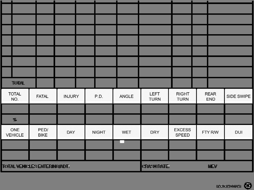
7 FLORIDA DEPARTMENT OF TRANSPORTATION DISTRICT 7 Pedestrian and Bicycle Crash History Between 2010 and 2014, there were 7 pedestrian and 13 bicycle crashes reported at or near the intersection of US 19 and 80th Ave N. The crashes within this time period resulted in 18 injuries, but no fatalities. Table 1 provides a breakdown of the pedestrian and bicycle crashes by total crashes and by the number of injuries and fatalities. Figure 7 illustrates the location and action/direction of the involved parties of each pedestrian/bicycle crash. Table 1: Pedestrian and Bicycle Crashes ( ) Total Crashes Number of Injuries Number of Fatalities Pedestrian Crashes Bicycle Crashes TOTAL Source: FDOT District 7 Web based Crash Data Management System Source: FDOT District 7 Web based Crash Data Management System Figure 7: Pedestrian and bicycle collisions, DRAFT JUNE 2016 TRANSIT SAFETY ASSESSMENT

8 DISTRICT WIDE BICYCLE/PEDESTRIAN ACCESS TO TRANSIT SAFETY ASSESSMENT AND IMPROVEMENT PLAN Transit Safety Assessment Summary Following the RSA model, a TSA was conducted to answer the following questions: What elements of the road may present a safety concern: to what extent, to which road users, and under what circumstances? What opportunities exist to eliminate or mitigate identified safety concerns? The observations and suggestions for consideration in this report are the result of the field assessment and were developed by the members of the TSA team (listed below). Although there was an effort to identify any fatal flaws in the field, some of the suggestions will require further engineering level assessment/analysis. The TSA of US 19 and 80 th Ave N was conducted on Thursday April 21, 2016, from 2:00 3:30 PM in clear weather conditions. The TSA was conducted by the following members of the TSA team: Sarah Perch Pinellas County MPO Sgt. George Edmiston Tindale Oliver Christopher Keller Tindale Oliver Demian Miller Tindale Oliver Justin Willits Tindale Oliver The following pages contain a detailed summary of the observations and suggestions for consideration that resulted from the TSA. Figure 9 serves as a reference map showing the approximate location of the observations and suggestions, and Table 2 provides a summary of the observations and suggestions. SR55/US 19 AT 80TH AVE N DRAFT JUNE

9 FLORIDA DEPARTMENT OF TRANSPORTATION DISTRICT 7 Figure 8: TSA observation reference map 8 DRAFT JUNE 2016 TRANSIT SAFETY ASSESSMENT
10 DISTRICT WIDE BICYCLE/PEDESTRIAN ACCESS TO TRANSIT SAFETY ASSESSMENT AND IMPROVEMENT PLAN Table 2: Summary of Observations and Suggestions for Consideration ID Location Description Observation Overview Suggestions for Consideration Agency Northeast quadrant of US 19 and 80 th Avenue N Intersection of US 19 and 80 th Ave N Intersection of US 19 and 80 th Avenue N 4 US 19 at 78 th Ave N 5 Driveway south of 80 th Ave N along west side of US 19 Worn pedestrian pathway from intersection to Walmart parking lot No crosswalk on south side of intersection Intersection improvements Evidence of pedestrians crossing US 19 at uncontrolled intersection Trip hazard loose truncated dome pad Explore opportunities to provide sidewalk. Consider installing signage to direct pedestrians to crosswalk on north side of intersection. Consider various intersection improvements Evaluate existing lighting levels at intersection and consider enlarging directional left turn island to provide median refuge. Remove truncated dome pad. Pinellas Park 6 US 19 at 80 th Ave N Worn crosswalk markings Rehab existing crosswalk markings. FDOT 7 US 19 at 82 nd Ave N Dual stop bar markings Remove duplicate stop bar marking. FDOT FDOT FDOT FDOT FDOT 9 US 19 at 82 nd Ave N US 19 at 80 th Ave N (bus stop #3029) Awkward crossing along west side of US 19 across 82 nd Ave N Bus stop landing pad may not be ADAcompliant Consider providing raised channelized right turn island and marked crossing. Consider evaluating bus stop landing pad area to ensure ADA compliance. FDOT PSTA SR55/US 19 AT 80TH AVE N DRAFT JUNE
11 FLORIDA DEPARTMENT OF TRANSPORTATION DISTRICT 7 ID Location Description: Observation Overview: Suggestion for Consideration: 1 Northeast quadrant of US 19 and 80 th Avenue N Worn pedestrian pathway from intersection to Walmart parking lot Explore opportunities to provide sidewalk. Observation Detail: Clearly worn path adjacent to Walmart entrance on north side, indicating regular pedestrian use. Suggestion for Consideration Detail: Explore opportunities to coordinate with Walmart and gas station to provide sidewalk connection from Walmart parking lot to intersection along north side of entrance driveway. Agency: Improvement Type: Level of Effort: Pinellas Park Pedestrian Medium EEE: Engineering Timeframe: Short Term Comment: 10 DRAFT JUNE 2016 TRANSIT SAFETY ASSESSMENT


12 DISTRICT WIDE BICYCLE/PEDESTRIAN ACCESS TO TRANSIT SAFETY ASSESSMENT AND IMPROVEMENT PLAN Potential area for sidewalk connction to gas station at northeast corner of US 19 and 80 th Ave N Location of Walmart driveway entrance SR55/US 19 AT 80TH AVE N DRAFT JUNE
13 FLORIDA DEPARTMENT OF TRANSPORTATION DISTRICT 7 ID Location Description: Observation Overview: Suggestion for Consideration: 2 Intersection of US 19 and 80 th Ave N No crosswalk on south side of intersection Consider installing signage to direct pedestrians to crosswalk on north side of intersection. Observation Detail: No marked crosswalk along southern leg of US 19 at 80 th Ave N intersection. Suggestion for Consideration Detail: Consider installing NO PEDESTRIAN CROSSING (MUTCD R9 3) and supplemental USE CROSSWALK (MUTCD R9 3bP) signage within median south of intersection (near existing bus stops) to guide pedestrians to marked crosswalk along northern leg of the intersection. Additionally, evaluate existing traffic signal phasing and timings to determine feasibility and potential signal phasing/timing impacts of providing marked crossing along south leg of intersection. Agency: Improvement Type: Level of Effort: FDOT Signage Low EEE: Engineering Timeframe: Short Term Comment: 12 DRAFT JUNE 2016 TRANSIT SAFETY ASSESSMENT


14 DISTRICT WIDE BICYCLE/PEDESTRIAN ACCESS TO TRANSIT SAFETY ASSESSMENT AND IMPROVEMENT PLAN Location where no marked crosswalk is present Potential signage placement SR55/US 19 AT 80TH AVE N DRAFT JUNE
15 FLORIDA DEPARTMENT OF TRANSPORTATION DISTRICT 7 ID Location Description: Observation Overview: Suggestion for Consideration: 3 Intersection of US 19 and 78 th Avenue N Intersection improvements Consider various intersection improvements. Observation Detail: There was no marked crosswalk on the west side of US 19 crossing 78 th Avenue N. There were two curb ramps on the north side of 78 th Avenue N and one on the south side. One of the ramps on the north side had a detectable warning, the other two ramps did not and appeared to be non compliant with ADA standards. The apparent path between both curb ramps on the north side appeared to be at an awkward diagonal angle to the south side, making the distance to cross the intersection further than likely necessary. Additionally, the sidewalk on the north side of 78 th Avenue N was not connected to the sidewalk and ramp with the detectable warning along US 19. Suggestion for Consideration Detail: Consider providing marked crosswalk across 78 th Ave N along west side of US 19. Additionally, consider installing raised channelized right turn island (similar to design at 80 th Ave N) within existing painted area and realigning crossing along west side of US 19 at 78 th Ave N. Consider connecting the sidewalk on the north side of 78 th Avenue N to the sidewalk and curb ramp along US 19. Agency: Improvement Type: Level of Effort: FDOT Signal Low EEE: Engineering Timeframe: Short Term Comment: 14 DRAFT JUNE 2016 TRANSIT SAFETY ASSESSMENT


16 DISTRICT WIDE BICYCLE/PEDESTRIAN ACCESS TO TRANSIT SAFETY ASSESSMENT AND IMPROVEMENT PLAN Location of pedestrian curb ramps and unmarked path between View from pedestrian ramp to pedestrian ramp on west side of US 19 at 78 th Ave N, looking north SR55/US 19 AT 80TH AVE N DRAFT JUNE
17 FLORIDA DEPARTMENT OF TRANSPORTATION DISTRICT 7 ID Location Description: Observation Overview: Suggestion for Consideration: 4 US 19 at 78 th Ave N Evidence of pedestrians crossing US 19 at uncontrolled intersection. Evaluate existing lighting levels at intersection and consider enlarging directional left turn island to provide median refuge. Observation Detail: Evidence of pedestrian crossing observed in field, through discussions with Pinellas Park Police, and through pedestrian and bicycle crash history at this location. Suggestion for Consideration Detail: Consider opportunities to provide enhanced median refuge options at this location by evaluating feasibility of providing larger left turn channelization island. Additionally, evaluate existing lighting levels at this location. Agency: Improvement Type: Level of Effort: FDOT Pedestrian Medium EEE: Engineering Timeframe: Mid Term Comment: 16 DRAFT JUNE 2016 TRANSIT SAFETY ASSESSMENT


18 DISTRICT WIDE BICYCLE/PEDESTRIAN ACCESS TO TRANSIT SAFETY ASSESSMENT AND IMPROVEMENT PLAN Aerial of US 19 and 78 th Ave N Example of pedestrian crossing at 78 th Ave N SR55/US 19 AT 80TH AVE N DRAFT JUNE
19 FLORIDA DEPARTMENT OF TRANSPORTATION DISTRICT 7 ID Location Description: Observation Overview: Suggestion for Consideration: 5 Driveway south of 80 th Ave N along west side of US 19 Trip hazard loose truncated dome pad Remove truncated dome pad. Observation Detail: Truncated dome pad located along north side of driveway along west side of US 19, south of 80 th Ave N becoming loose and is potential trip hazard. Truncated dome pads at non intersection locations such as driveways give impression that sidewalk does not continue through driveway and that pedestrian does not have right of way. Suggestion for Consideration Detail: Consider removing or repairing/replacing damaged truncated dome pad to eliminate potential trip hazard. Agency: Improvement Type: Level of Effort: FDOT Maintenance Low EEE: Engineering Timeframe: Short Term Comment: 18 DRAFT JUNE 2016 TRANSIT SAFETY ASSESSMENT


20 DISTRICT WIDE BICYCLE/PEDESTRIAN ACCESS TO TRANSIT SAFETY ASSESSMENT AND IMPROVEMENT PLAN Location of loose truncated dome pad Truncated dome pad loose and is potential trip hazard SR55/US 19 AT 80TH AVE N DRAFT JUNE
21 FLORIDA DEPARTMENT OF TRANSPORTATION DISTRICT 7 ID Location Description: Observation Overview: Suggestion for Consideration: 6 US 19 at 80 th Ave N Worn crosswalk markings Rehab existing crosswalk markings Observation Detail: Existing crosswalk markings beginning to show significant wear, reducing visibility of markings to drivers. Suggestion for Consideration Detail: Consider rehabilitating the existing crosswalk markings. Agency: Improvement Type: Level of Effort: FDOT Pavement Markings Low EEE: Engineering Timeframe: Short Term Comment: 20 DRAFT JUNE 2016 TRANSIT SAFETY ASSESSMENT


22 DISTRICT WIDE BICYCLE/PEDESTRIAN ACCESS TO TRANSIT SAFETY ASSESSMENT AND IMPROVEMENT PLAN Aerial of US 19 and 80 th Ave Worn crosswalk on east side of US 19 at 80 Th Ave SR55/US 19 AT 80TH AVE N DRAFT JUNE
23 FLORIDA DEPARTMENT OF TRANSPORTATION DISTRICT 7 ID Location Description: Observation Overview: Suggestion for Consideration: 7 US 19 at 82 nd Ave N Dual stop bar markings Remove duplicate stop bar marking. Observation Detail: Two stop bar markings on westbound approach to US 19 along 82 nd Ave N; both severely worn and appear in need of rehabilitation. Suggestion for Consideration Detail: Consider removing duplicate stop bar marking and rehabilitating remaining stop bar marking to improve visibility. Agency: Improvement Type: Level of Effort: FDOT Pavement Markings Low EEE: Engineering Timeframe: Short Term Comment: 22 DRAFT JUNE 2016 TRANSIT SAFETY ASSESSMENT

24 DISTRICT WIDE BICYCLE/PEDESTRIAN ACCESS TO TRANSIT SAFETY ASSESSMENT AND IMPROVEMENT PLAN Intersection of US 19 and 82 nd Ave N Two stop bar markings on east side of US 19 at 82 nd Ave N SR55/US 19 AT 80TH AVE N DRAFT JUNE
25 FLORIDA DEPARTMENT OF TRANSPORTATION DISTRICT 7 ID Location Description: Observation Overview: Suggestion for Consideration: 8 US 19 at 82 nd Ave N Awkward crossing along west side of US 19 across 82 nd Ave N Consider providing raised channelized right turn island and marked crossing. Observation Detail: Existing crossing of 82 nd Ave N along west side of US 19 is long and not clearly defined. Unmarked pedestrian crossing requires that pedestrians travel through painted right turn island with limited guidance. Suggestion for Consideration Detail: Consider applying crossing treatment similar to 80 th Ave N; provide raised right turn channelization island and marked crosswalk to reduce pedestrian exposure and provide better crossing guidance. Agency: Improvement Type: Level of Effort: FDOT Pedestrian Medium EEE: Engineering Timeframe: Mid Term Comment: 24 DRAFT JUNE 2016 TRANSIT SAFETY ASSESSMENT

26 DISTRICT WIDE BICYCLE/PEDESTRIAN ACCESS TO TRANSIT SAFETY ASSESSMENT AND IMPROVEMENT PLAN Intersection of US 19 and 82 nd Ave N Unmarked crossing on west side of US 19 at 82 nd Ave N SR55/US 19 AT 80TH AVE N DRAFT JUNE
27 FLORIDA DEPARTMENT OF TRANSPORTATION DISTRICT 7 ID Location Description: Observation Overview: Suggestion for Consideration: 9 US 19 at 80 th Ave N (bus stop #3029) Bus stop landing pad may not be ADAcompliant. Consider evaluating bus stop landing pad area to ensure ADA compliance. Observation Detail: Existing bus stop landing pad appears to be 5 x 8, but pedestrian hand rail on pad appears to be encroaching within required 5 x 8 clear zone. Suggestion for Consideration Detail: Consider evaluating existing bus stop landing pad area to ensure ADA compliance. Agency: Improvement Type: Level of Effort: PSTA ADA Low EEE: Engineering Timeframe: Short Term Comment: 26 DRAFT JUNE 2016 TRANSIT SAFETY ASSESSMENT


28 DISTRICT WIDE BICYCLE/PEDESTRIAN ACCESS TO TRANSIT SAFETY ASSESSMENT AND IMPROVEMENT PLAN Aerial of Bus Stop #3029, US 19 south of 80th Ave N Bus stop #3029, US 19 south of 80th Ave N SR55/US 19 AT 80TH AVE N DRAFT JUNE
29 Florida Department of Transportation District N. Malcolm McKinley Drive Tampa, FL 33612
30 DRAFT US 19 and 80th Avenue Transportation Safety Audit Appendix A: US 19 and 80th Avenue Crash Diagram A-1

31
32
33
Road Safety Assessment
 Road Safety Assessment Team Findings Report July 2013 Page 1 of 36 Introduction East Bay Drive from Lake Avenue to Keene Road The Federal Highway Administration s (FHWA) Safety Office established Road
PEDESTRIAN SAFETY STUDY
 PEDESTRIAN SAFETY STUDY SR 699 (BLIND PASS RD/GULF BLVD) FROM 93 RD AVENUE TO PINELLAS BAYWAY PINELLAS COUNTY SECTION NO.: 15100 MILEPOST: 0.111 3.569 STUDY LIMITS Prepared For: Florida Department of Transportation
BICYCLE/PEDESTRIAN ACCESS TO TRANSIT SAFETY ASSESSMENT FOR EXISTING AND PLANNED SECTIONS OF US 19
 BICYCLE/PEDESTRIAN ACCESS TO TRANSIT SAFETY ASSESSMENT FOR EXISTING AND PLANNED SECTIONS OF US 19 Project Advisory Committee Meeting December 2, 2015 A JOINT EFFORT OF THE PINELLAS METROPOLITAN PLANNING
LANE ELIMINATION PROJECTS
 PRESENTATION OUTLINE Lane Elimination Considerations Districts 4 & 7 Draft Lane Elimination Processes FDOT Lane Elimination Guidelines Example Projects D4 Case Study: SR A1A (Ft. Lauderdale) D7 Case Study:
District 7 Road Safety Assessment. SR 60 (Gulf to Bay Boulevard) at CR 501 (S Belcher Road)
 at CR 501 (S Belcher Road)") District 7 Road Safety Assessment Team Findings Summary SR 60 (Gulf to Bay Boulevard) at CR 501 (S Belcher Road) Section: 15 040 000 MP: 3.441 July 2014 7 /28/2014 4:04:59 PM RSA Findings Summary Gulf
District 7 Road Safety Assessment Team Findings Summary SR 60 (Gulf to Bay Boulevard) at CR 501 (S Belcher Road) Section: 15 040 000 MP: 3.441 July 2014 7 /28/2014 4:04:59 PM RSA Findings Summary Gulf
RSA Efforts in the Tampa Bay Area
 RSA Efforts in the Tampa Bay Area Presentation to the RSA Regional Peer Exchange April 29, 2008 -- Little Rock, Arkansas Peter Hsu, PE, Florida Department of Transportation District 7 Overview Introduction
District 4 Road Safety Audit Report
 District 4 Road Safety Audit Report SR-704 (Okeechobee Boulevard) AT Florida Avenue / Rosemary Avenue Section: 93 280 000 Mile Post: 8.881 Section: 93 280 001 Mile Post: 0.522 Task Work Order No. 19 Contract
Orange Center Elementary School
 Drag and drop pic and stretch/crop to the limits of the blue rectangle (delete this text box) Orange Center Elementary School Drag and drop pic and stretch/crop to the limits of the blue rectangle (delete
US 19 Pedestrian and Bicycle Safe Access to Transit Corridor Study
 US 19 Pedestrian and Bicycle Safe Access to Transit Corridor Study DRAFT Technical Memorandum #3 Active Bus Stop Review and Observations August 2016 Prepared for: FLORIDA DEPARTMENT OF TRANSPORTATION DISTRICT
Multi-Modal Traffic Analysis. Parisi and Associates
 Mill Valley to Corte Madera Bicycle and Pedestrian Corridor Study Appendix D: Multi-Modal Traffic Analysis Prepared by Parisi and Associates August 2009 Appendix D - Multi-Modal Traffic Analysis Table
Hillsborough Pedestrian Safety Action Plan 2015 Update. Hillsborough MPO BPAC May 2015
 Hillsborough Pedestrian Safety Action Plan 2015 Update Hillsborough MPO BPAC May 2015 Presentation Overview Pedestrian Safety Action Plan (PSAP) Review Pedestrian Crash Trends Stakeholder Activities Engineering
SR/CR A1A PEDESTRIAN SAFETY & MOBILITY STUDY RIVER TO SEA TRANSPORTATION PLANNING ORGANIZATION
 SR/CR A1A PEDESTRIAN SAFETY & MOBILITY STUDY RIVER TO SEA TRANSPORTATION PLANNING ORGANIZATION 2016 Florida Section ITE Annual Summer Meeting June 24, 2016 Today s Presenters Lois Bollenback Executive
AGENDA ITEM 6 D THOMASVILLE ROAD (HERMITAGE BOULEVARD TO LIVE OAK PLANTATION ROAD) ROADWAY SAFETY AUDIT
 ROADWAY SAFETY AUDIT") May 15, 2018 AGENDA ITEM 6 D THOMASVILLE ROAD (HERMITAGE BOULEVARD TO LIVE OAK PLANTATION ROAD) ROADWAY SAFETY AUDIT TYPE OF ITEM: Discussion STATEMENT OF ISSUE The Florida Department of Transportation
May 15, 2018 AGENDA ITEM 6 D THOMASVILLE ROAD (HERMITAGE BOULEVARD TO LIVE OAK PLANTATION ROAD) ROADWAY SAFETY AUDIT TYPE OF ITEM: Discussion STATEMENT OF ISSUE The Florida Department of Transportation
Overview of Pinellas County Pedestrian Safety Programs and Initiatives
 Overview of Pinellas County Pedestrian Safety Programs and Initiatives FHWA Pedestrian Safety Peer Exchange Miami, FL August 2, 2012 Peter Hsu, P.E. District Safety & Special Projects Engineer Florida
Board of Supervisors February 27, 2017
 : Traffic Analysis Results & Draft Conceptual Plan Board of Supervisors February 27, 2017 Transportation Solutions Building Better Communities Presentation Overview Background Summary of Traffic Analysis
Pinellas County Safety Initiatives
 Florida Department of TRANSPORTATION Pinellas County Safety Initiatives Whit Blanton, FAICP Pinellas County MPO A Distinctive County A unique geography Multi-jurisdictional Key demographics seniors and
5. RUNNINGWAY GUIDELINES
 5. RUNNINGWAY GUIDELINES These guidelines should be considered collectively when making runningway decisions. A runningway is the linear component of the transit system that forms the right-of-way reserved
Windy Ridge Elementary School
 Windy Ridge Elementary School SCHOOL ROUTE PLAN For WINDY RIDGE ELEMENTARY SCHOOL LOCATION 54 ORANGE COUNTY Prepared for: ORANGE COUNTY SCHOOL ASSESSMENT PROGRAM ORANGE COUNTY PUBLIC WORKS Traffic Engineering
Pedestrian Project List and Prioritization
 To: Kyle Wagenschutz, City of Memphis CC: From: Anne Conlon and John Cock, Alta Planning + Design Date: December, 2014 Re: Project List Development (Task 3.1-3.2) and Project List Prioritization (Task
F L E T C H E R A V E N U E
 Jan. 29, 2014 Introduction F L E T C H E R A V E N U E FDOT Local Agency Program (LAP) Project FPN: 428214-1-58-01 CIP 63090 Hillsborough County, Traffic Engineering, PWD Stake holders and partners are
KIETZKE LANE SAFETY MANAGEMENT PLAN FINAL REPORT August, 2013 Submitted By: Parsons. Submitted to:
 KIETZKE LANE SAFETY MANAGEMENT PLAN FINAL REPORT August, 2013 Submitted By: Parsons Submitted to: KIETZKE LANE SAFETY MANAGEMENT PLAN EXECUTIVE SUMMARY The Nevada Department of Transportation (NDOT) has
CITY OF KASSON TRANSPORTATION ALTERNATIVES KASSON SAFE ROUTES TO SCHOOL
 ve ha 8t G B A Mantorville Ave N 240th Ave 16th St NE 11th Ave NE K-M HIGH SCHOOL SUNRISE TRAIL TO MANTORVILLE MNTH 57 SUNSET TRAIL TO MANTORVILLE NE PARK 16TH ST NE TRAIL K-M ELEMENTARY SCHOOL K-M MIDDLE
Meadow Woods Elementary School
 Drag and drop pic and stretch/crop to the limits of the blue rectangle (delete this text box) Meadow Woods Elementary School Drag and drop pic and stretch/crop to the limits of the blue rectangle (delete
SR 693 (Pasadena Avenue) Corridor Study from Shore Drive South to 66 th Street
 Corridor Study from Shore Drive South to 66 th Street") Welcome and Introduction Sign-in and comment sheets Restrooms and exits Meeting agenda and timeline Meeting goals / expectations Provide input to guide study recommendations Actively participate throughout
Welcome and Introduction Sign-in and comment sheets Restrooms and exits Meeting agenda and timeline Meeting goals / expectations Provide input to guide study recommendations Actively participate throughout
APPENDIX A: Complete Streets Checklist DRAFT NOVEMBER 2016
 APPENDIX A: Complete Streets Checklist DRAFT NOVEMBER 2016 Complete Streets Checklist MetroPlan Orlando s Complete Streets Checklist is an internal planning tool for staff to further implementation of
Road Diets FDOT Process
 Florida Department of TRANSPORTATION Road Diets FDOT Process Humberto Castillero, PE, PTOE Roadway Design Office Purpose of Guide Develop a statewide lane elimination review process Balance state & local
ROAD SAFETY AUDIT. Blue Hill Avenue (Route 28) and Warren Street High Crash Locations City of Boston. November 1, 2016
 and Warren Street High Crash Locations City of Boston. November 1, 2016") ROAD SAFETY AUDIT Blue Hill Avenue (Route 28) and Warren Street High Crash Locations City of Boston November 1, 2016 Prepared For: MassDOT Highway Division Prepared By: BETA Group, Inc. Table of Contents
ROAD SAFETY AUDIT Blue Hill Avenue (Route 28) and Warren Street High Crash Locations City of Boston November 1, 2016 Prepared For: MassDOT Highway Division Prepared By: BETA Group, Inc. Table of Contents
Meeting Schedule 7:00-7:15 Open House 7:15-7:45 Existing Conditions/Short-Term Improvements Study Presentation 7:45-8:00 Q&A Session 8:00-8:10
 Meeting Schedule 7:00-7:15 Open House 7:15-7:45 Existing Conditions/Short-Term Improvements Study Presentation 7:45-8:00 Q&A Session 8:00-8:10 Long-Term Study Presentation 8:10-8:40 Table Discussions 8:40-9:00
Safety Emphasis Areas & Safety Project Development Florida Department of Transportation District Seven Tampa Bay
 Safety Emphasis Areas & Safety Project Development Florida Department of Transportation District Seven Tampa Bay Stephen L. Benson, AICP, CNU-A FDOT District Seven Safety Office Presentation Overview Safety
Golden Gate Park. Project Goal and Description. Lower Great Highway Facts
 PROJECT OVERVIEW Project Goal and Description The goal of the is to increase pedestrian safety and comfort along Lower Great Highway by evaluating and implementing near- and medium-term pedestrian improvements
CAPITOL DRIVE & FOND DU LAC AVENUE INTERSECTION ANALYSIS. Urban Planning 772 SARAH BREGANT, RYAN PETERSON, & MATT WERDERITCH
 CAPITOL DRIVE & FOND DU LAC AVENUE INTERSECTION ANALYSIS Urban Planning 772 SARAH BREGANT, RYAN PETERSON, & MATT WERDERITCH OVERVIEW N 51 ST BOULEVARD N 51 ST BOULEVARD 12,100 44,700 W CAPITOL DRIVE 52,600
Pine Hills Road Pedestrian/Bicycle Safety Study Board of County Commissioners Work Session
 Pine Hills Road Pedestrian/Bicycle Safety Study Board of County Commissioners Work Session February 20, 2018 Meeting Agenda Study Overview Existing Conditions Access Management Potential Gateway Features
ROAD SAFETY AUDIT. State Road (Route 6) Corridor Town of Dartmouth. March Prepared For: MassDOT
 Corridor Town of Dartmouth. March Prepared For: MassDOT") ROAD SAFETY AUDIT State Road (Route 6) Corridor Town of Dartmouth March 2015 Prepared For: MassDOT Prepared By: McMahon Associates, Inc. 300 Myles Standish Blvd. Suite 201 Taunton, MA 02780 Table of Contents
ROAD SAFETY AUDIT State Road (Route 6) Corridor Town of Dartmouth March 2015 Prepared For: MassDOT Prepared By: McMahon Associates, Inc. 300 Myles Standish Blvd. Suite 201 Taunton, MA 02780 Table of Contents
BICYCLE/PEDESTRIAN ACCESS TO TRANSIT SAFETY ASSESSMENT FOR EXISTING AND PLANNED SECTIONS OF US 19
 BICYCLE/PEDESTRIAN ACCESS TO TRANSIT SAFETY ASSESSMENT FOR EXISTING AND PLANNED SECTIONS OF US 19 Project Advisory Committee Meeting January 27, 2016 A JOINT EFFORT OF THE PINELLAS METROPOLITAN PLANNING
Transportation Planning Division
 Transportation Planning Division Presentation Outline Study Tasks Recap of Previous Meetings Data Collected Focus Areas within Study Limits Design Principles Tool Box Recommended Concepts Schedule Moving
Executive Summary Route 30 Corridor Master Plan
 Route Corridor Master Plan Project Overview The Route Corridor Master Plan is a coordinated multimodal transportation and land use plan for the entire stretch of Route through East Whiteland Township,
US 41 (Tamiami Trail) Corridor Study. Roadway Safety Audit
 Corridor Study. Roadway Safety Audit") US 41 (Tamiami Trail) Corridor Study Roadway Safety Audit US 41 RSA June 14/15, 2017 Agenda Project Overview Schedule RSA Process Overview RSA Responsibilities Historical Crash Review 2 PROJECT OVERVIEW
US 41 (Tamiami Trail) Corridor Study Roadway Safety Audit US 41 RSA June 14/15, 2017 Agenda Project Overview Schedule RSA Process Overview RSA Responsibilities Historical Crash Review 2 PROJECT OVERVIEW
Appendix T CCMP TRAIL TRAFFIC & TRANSPORTATION DESIGN STANDARD
 Appendix T CCMP 3.3.4 TRAIL TRAFFIC & TRANSPORTATION DESIGN STANDARD 3.3.4 Trail Traffic and Transportation Design Multi-use trails have certain design standards, which vary depending on the agency that
Tonight is for you. Learn everything you can. Share all your ideas.
 Strathcona Neighbourhood Renewal Draft Concept Design Tonight is for you. Learn everything you can. Share all your ideas. What is Neighbourhood Renewal? Creating a design with you for your neighbourhood.
ADA Transition Plan. City of Gainesville FY19-FY28. Date: November 5, Prepared by: City Of Gainesville Department of Mobility
 ADA Transition Plan FY19-FY28 Date: November 5, 2018 Prepared by: City Of Gainesville Department of Mobility 1.0 INTRODUCTION 1.1 BACKGROUND The federal statute known as the Americans with Disabilities
BOARD OF COUNTY COMMISSIONERS AGENDA ITEM SUMMARY
 7B BOARD OF COUNTY COMMISSIONERS AGENDA ITEM SUMMARY PLACEMENT: REQUESTS AND PRESENTATIONS PRESET: TITLE: FLORIDA DEPARTMENT OF TRANSPORTATION (FDOT) PRESENTATION RECONSTRUCTION OF SR-76 (SW KANNER HIGHWAY)
Pedestrian Safety Guide for Transit Agencies
 Pedestrian Safety Guide for Transit Agencies FDOT/FTPA/CUTR Professional Development Workshop June 15, 2010 1 Purpose Presentation Overview Bus Stop Location and Design Process/Partnership 2 Purpose Every
ROAD SAFETY AUDIT. Granite Avenue at Interstate 93 Ramps. Town of Milton. May 22, Prepared for: MassDOT
 ROAD SAFETY AUDIT Granite Avenue at Interstate 93 Ramps Town of Milton May 22, 2017 Prepared for: MassDOT Prepared by: Toole Design Group 2 Oliver Street, Suite 305 Boston, MA 02109 Table of Contents Background...
Long Island Rail Road Expansion Project Floral Park to Hicksville
 Long Island Rail Road Expansion Project Floral Park to Hicksville Final Environmental Impact Statement Appendix 1-D Complete Streets Policy Checklist April 2017 0902ML PIN: Project Location: 18A-4 Floral
ADA & Public Rights of Way
 ADA & Public Rights of Way Overview of Current and Up-coming Requirements FDOT Design Training Expo 2012 Orlando, FL Dean Perkins, RA - ADA Coordinator Florida Department of Transportation Office of Design,
Coquitlam Cross-town Bike Route Improving Bicycle Facilities in a Mature Suburban Environment
 Coquitlam Cross-town Bike Route Improving Bicycle Facilities in a Mature Suburban Environment Sarah Rocchi, Vice-President, Projects, Opus International Consultants (Main Presenter) Catherine Mohoruk,
Pine Hills Road Pedestrian/Bicycle Safety Study Community Meeting #1
 Pine Hills Road Pedestrian/Bicycle Safety Study Community Meeting #1 June 8, 2017 Meeting Agenda Study Overview Community Survey Existing Conditions Access Management Potential Safety Countermeasures Potential
Overview of FDOT District 7 Safety Programs and Initiatives in Tampa Bay, FL
 Overview of FDOT District 7 Safety Programs and Initiatives in Tampa Bay, FL Executive Safety Summit Florida Department of Transportation District 7 June 8, 2011 Peter Hsu, P.E. District Safety & Special
Access Management in the Vicinity of Intersections
 Access Management in the Vicinity of Intersections FHWA-SA-10-002 Technical Summary Photo: Ralph Bentley (used with permission) 0 Access Management is: The design, implementation and management of entry
Americans with Disabilities Act Transition Plan for Public Right-of-Way Improvements
 Americans with Disabilities Act Transition Plan for Public Right-of-Way Improvements Prepared by: Public Works Department Engineering Division October 2015 Table of Contents Section I Introduction.. 3
C C C
 C-012-001 Thank you for your support for the creation of new public space and nonmotorized access between downtown and the waterfront through the Overlook Walk, the East-West Connections, and the Promenade.
US 19 PEDESTRIAN AND BICYCLE SAFE ACCESS
 US 19 PEDESTRIAN AND BICYCLE SAFE ACCESS TO TRANSIT CORRIDOR STUDY A JOINT EFFORT OF THE FLORIDA DEPARTMENT OF TRANSPORTATION AND FORWARD PINELLAS (F.K.A. PINELLAS COUNTY METROPOLITAN PLANNING ORGANIZATION)
Bicycle Master Plan Goals, Strategies, and Policies
 Bicycle Master Plan Goals, Strategies, and Policies Mobilizing 5 This chapter outlines the overarching goals, action statements, and action items Long Beach will take in order to achieve its vision of
PEDESTRIAN / BICYCLE SAFETY REVIEW
 PEDESTRIAN / BICYCLE SAFETY REVIEW Palm Bay Road from Babcock Street to Lipscomb Street Prepared for: Space Coast Transportation Planning Organization 2725 Judge Fran Jamieson Way Bldg. B / Room 05 / MS
Downtown Naples Mobility and Connectivity Study. Naples City Council Presentation January 2017
 Downtown Naples Mobility and Connectivity Study Naples City Council Presentation January 2017 Agenda 1. Introduction 2. Scope Review 3. Project Schedule 4. Existing Conditions 5. Public Charrette 6. Mobility
GRANDFORKS MILSPURFEASIBILITYSTUDY. GrandForksandEastGrandForksMPO. FINALReport. August2010
 GRADFORKS MILSPURFEASIBILITYSTUDY GrandForksandEastGrandForksMPO FIALReport August2010 Table of Contents Chapter 1: Introduction and Background... 1 Chapter 2: Existing Conditions and Issues Identification...
What Is a Complete Street?
 Session 5 Charleen Zimmer, AICP, Zan Associates May 5-7, 2010 What Is a Complete Street? May 2010 5-1 Not a Complete Street More of a Complete Street May 2010 5-2 Benefits of Complete Streets Safety for
Improvements Infrastructure Gap Assessment and Improvements Street Striping
 Infrastructure Project Proposal The federal-aid Safe Routes to School program funds infrastructure/engineering projects that fall into two categories: Design (available only to School Development Authority
Off-road Trails. Guidance
 Off-road Trails Off-road trails are shared use paths located on an independent alignment that provide two-way travel for people walking, bicycling, and other non-motorized users. Trails specifically along
Dell Range Boulevard Corridor Study Powderhouse Road to College Drive. Prepared for: Cheyenne Metropolitan Planning Organization
 Dell Range Boulevard Corridor Study Powderhouse Road to College Drive Prepared for: Cheyenne Metropolitan Planning Organization Draft August 2014 Dell Range Boulevard Corridor Study (Powderhouse Road to
Final Sidewalk Feasibility Study
 Garfield Drive From Anastasia Drive to Elizabeth Place City of South Daytona July 23, 2009 Final Sidewalk Feasibility Study Prepared for: Prepared by: Final Sidewalk Feasibility Study Garfield Drive 2
Ottawa Beach Road Study
 Ottawa Beach Road Study Prepared For: Park Township September 30, 2014 Project No. G140303 OTTAWA BEACH ROAD STUDY PREPARED FOR: PARK TOWNSHIP SEPTEMBER 30, 2014 PROJECT NO. G140303 TABLE OF CONTENTS 1.0
Chapter 5 DATA COLLECTION FOR TRANSPORTATION SAFETY STUDIES
 Chapter 5 DATA COLLECTION FOR TRANSPORTATION SAFETY STUDIES 5.1 PURPOSE (1) The purpose of the Traffic Safety Studies chapter is to provide guidance on the data collection requirements for conducting a
Pedestrian, Bicycle and Traffic Calming Strategic Implementation Plan. January 18, 2011
 Pedestrian, Bicycle and Traffic Calming Strategic Implementation Plan January 18, 2011 Tonight s Agenda Receive update on project Provide feedback on two policy issues Complete Streets Policy Project Prioritization
Hidden Oaks Elementary School
 Hidden Oaks Elementary School SCHOOL ROUTE PLAN For HIDDEN OAKS ELEMENTARY SCHOOL LOCATION 13 ORANGE COUNTY Prepared for: ORANGE COUNTY SCHOOL ASSESSMENT PROGRAM ORANGE COUNTY PUBLIC WORKS Traffic Engineering
ROUTE 81 CORRIDOR STUDY DESIGN CONCEPTS
 RT 81 Corridor Study CLINTON ROUTE 81 CORRIDOR STUDY DESIGN CONCEPTS View north on High Street, with potential improvements to the streetscape Draft Recommendations November 8 th, 2018 TOWN OF CLINTON
COMMUNITY MEETING AGENDA
 COMMUNITY MEETING AGENDA Welcome and Introductions SAFE Presentation Project Presentation Priorities Feedback Next Steps Q&A Santa Cruz Avenue Corridor Study 1 Santa Cruz Avenue Corridor Study Community
Memorandum. Sunday, July 13, Saturday, July 19, 2014
 Memorandum To: David Lowin, Brooklyn Bridge Park Corporation From: Daniel Schack, AICP, PTP Date: Re: Brooklyn Bridge Park Pier 5/6 Loop Road Traffic Study Project No: 14-01-2407 At the request of Brooklyn
Improving Cyclist Safety at the Dundas Street West and Sterling Road Intersection
 STAFF REPORT ACTION REQUIRED Improving Cyclist Safety at the Dundas Street West and Sterling Road Intersection Date: August 17, 2012 To: From: Wards: Reference Number: Public Works and Infrastructure Committee
REGIONAL BICYCLE AND PEDESTRIAN DESIGN GUIDELINES
 REGIONAL BICYCLE AND PEDESTRIAN DESIGN GUIDELINES November 16, 2011 Deb Humphreys North Central Texas Council of Governments Bicycle and Pedestrian Advisory Committee Snapshot of the Guide 1. Introduction
SR 907 (Alton Road) between Barry Street and 41 st Street
 between Barry Street and 41 st Street") TWO 20 Pedestrian Safety Study SR 907 (Alton Road) between Barry Street and 41 st Street Miami Beach, Miami-Dade County DRAFT Florida Department of Transportation District VI June 2014 TWO 20 Pedestrian
TWO 20 Pedestrian Safety Study SR 907 (Alton Road) between Barry Street and 41 st Street Miami Beach, Miami-Dade County DRAFT Florida Department of Transportation District VI June 2014 TWO 20 Pedestrian
About the Studio. Edward J. Bloustein School of Planning and Public Policy - Rutgers University
 About the Studio Edward J. Bloustein School of Planning and Public Policy - Rutgers University Purpose of studio: Help City of Bayonne apply for Safe Routes to School (SRTS) funding by producing a School
Road Safety Audit for the Intersection of VFW Highway & Bridge Street in Lowell, Massachusetts
 Road Safety Audit for the Intersection of VFW Highway & Bridge Street in Lowell, Massachusetts Prepared by University of Massachusetts Traffic Safety Research Program Prepared for Massachusetts Highway
Public Involvement Kickoff Meeting. April 29, 2015
 Public Involvement Kickoff Meeting April 29, 2015 Title VI Compliance The Florida Department of Transportation complies with various non-discrimination laws and regulations, including Title VI of the Civil
Project Advisory Group (PAG) Meeting #2 January 31, SR 693 (Pasadena Avenue) Corridor Study from Shore Drive South to 66 th Street
 Meeting #2 January 31, SR 693 (Pasadena Avenue) Corridor Study from Shore Drive South to 66 th Street") Project Advisory Group (PAG) Meeting #2 January 31, 2018 Welcome & Introductions AGENDA 1. Where are we at? 2. Project Survey / Virtual Comment Tool / PAG Meeting #1 / Visioning Workshop Corridor Map Exercise
Project Advisory Group (PAG) Meeting #2 January 31, 2018 Welcome & Introductions AGENDA 1. Where are we at? 2. Project Survey / Virtual Comment Tool / PAG Meeting #1 / Visioning Workshop Corridor Map Exercise
ADA on Construction. Guidance for Section C Plan Preparers
 ADA on Construction Guidance for Section C Plan Preparers Some impacts cannot be avoided and those impacts apply to residents, businesses, motorists, and pedestrians alike. However, good planning can minimize
Town of Wakarusa. Americans with Disabilities Act Transition Plan: Pedestrian Facilities in the Public Right-of-Way
 Town of Wakarusa Americans with Disabilities Act Transition Plan: Pedestrian Facilities in the Public Right-of-Way Table of Contents Introduction... 1 Legal Requirements... 1 Identified Obstacles to the
Moving Together Conference Complete Streets from the MassDOT District 5 Perspective
 Moving Together Conference Complete Streets from the MassDOT District 5 Perspective Timothy Kochan, Transportation Planner and Bicycle/ Pedestrian Coordinator District 5 Office Taunton S Overview of District
Drag and drop pic and stretch/crop to the limits of the blue rectangle (delete this text box) Maxey Elementary School
 Maxey Elementary School") Drag and drop pic and stretch/crop to the limits of the blue rectangle (delete this text box) Maxey Elementary School SCHOOL ROUTE PLAN For MAXEY ELEMENTARY SCHOOL LOCATION 33 ORANGE COUNTY Prepared for:
Drag and drop pic and stretch/crop to the limits of the blue rectangle (delete this text box) Maxey Elementary School SCHOOL ROUTE PLAN For MAXEY ELEMENTARY SCHOOL LOCATION 33 ORANGE COUNTY Prepared for:
Chapter 3.5 Osteen Elementary School. Volusia County MPO. November 2008
 Chapter 3.5 Osteen Elementary School Osteen, FL Volusia County MPO November 2008 Volusia County MPO School Bicycle and Pedestrian Review Study, Phase 3B School Summary Osteen Elementary School is located
US 19 Pedestrian and Bicycle Safe Access to Transit Corridor Study
 US 19 Pedestrian and Bicycle Safe Access to Transit Corridor Study DRAFT Technical Memorandum #6 Cost and Benefit Evaluation Methodology August 2016 Prepared for: FLORIDA DEPARTMENT OF TRANSPORTATION DISTRICT
PEDESTRIAN ACTION PLAN
 ATTACHMENT 2 CITY OF SANTA MONICA PEDESTRIAN ACTION PLAN CITY OF SANTA MONICA PEDESTRIAN ACTION PLAN This page intentionally left blank EXECUTIVE SUMMARY CHAPTER 1 EXECUTIVE SUMMARY Setting the Stage
Pedestrian Road Safety Audit
 Pedestrian Road Safety Audit Middlebrook Road From Father Hurley Boulevard to Waring Station Road December 2017 Montgomery County Department of Transportation Table of Contents 1. Introduction... 1 1.1
State Road 54/56 Tampa Bay s Northern Loop. The Managed Lane Solution Linking I-75 to the Suncoast Parkway
 State Road 54/56 Tampa Bay s Northern Loop The Managed Lane Solution Linking I-75 to the Suncoast Parkway SUNCOAST PARKWAY Both I 75 and the Suncoast Parkway are planning, or in the process of constructing,
Accommodating Pedestrians in the Work Zone
 Accommodating Pedestrians in the Work Zone Guidance for Section C Plan Preparers Some impacts cannot be avoided and those impacts apply to residents, businesses, motorists, and pedestrians alike. However,
CITY OF SARATOGA SPRINGS PEDESTRIAN CROSSING TOOLBOX
 CITY OF SARATOGA SPRINGS PEDESTRIAN CROSSING TOOLBOX This toolbox is to be used to guide pedestrian crossing improvements within the City of Saratoga Springs. Details for each crossing type are provided.
MEMORANDUM. Date: 9/13/2016. Citywide Crosswalk Policy
 MEMORANDUM Date: 9/13/2016 Re: Citywide Crosswalk Policy Foreword Through the s Circulation Element and Complete Streets Policy, it is the City s goal to promote walking trips and provide safe facilities
TRAFFIC IMPACT ANALYSIS
 TRAFFIC IMPACT ANALYSIS FOR THE CHAMPAIGN UNIT#4 SCHOOL DISTRICT PROPOSED HIGH SCHOOL (SPALDING PARK SITE) IN THE CITY OF CHAMPAIGN Final Report Champaign Urbana Urbanized Area Transportation Study 6/24/2014
Date: April 4, Project #: Re: A Street/Binford Street Traffic/Intersection Assessment
 To: Peter Cavanaugh General Electric From: David Bohn, PE Ryan White, PE Date: April 4, 217 Project #: 13421. Re: / Traffic/Intersection Assessment Consistent with the Cooperation Agreement between the
FEDERAL HIGHWAY ADMINISTRATION APPLICATION
 FEDERAL HIGHWAY ADMINISTRATION APPLICATION REQUEST FOR PERMISSION TO EXPERIMENT WITH A BICYCLE BOX INTERSECTION TREATMENT Submitted by: City of Columbus Department of Public Service Date: June 26, 2009
SR/CR A1A PEDESTRIAN SAFETY & MOBILITY STUDY
 SR/CR AA PEDESTRIAN SAFETY & MOBILITY STUDY PEDESTRIAN / BICYCLE SAFETY REVIEW Focus Area H / 9th Street S to 3th Street N Prepared for: River to Sea Transportation Planning Organization 2570 West International
Bicycle and Pedestrian Chapter TPP Update Overview. TAB September 20, 2017
 Bicycle and Pedestrian Chapter TPP Update Overview TAB September 20, 2017 Bicycling & Walking in the Twin Cities Where are we now? The Bike-Pedestrian system Current trends New developments Where are we
FINAL DESIGN TRAFFIC TECHNICAL MEMORANDUM
 FINAL DESIGN TRAFFIC TECHNICAL MEMORANDUM July 2014 FINAL (SR 43) Project Development and Environment Study From State Road 60 (Adamo Drive) to I-4 (SR 400) Hillsborough County, Florida Work Program Item
Bay to Bay Boulevard Complete Streets Project
 Bay to Bay Boulevard Complete Streets Project Dale Mabry Highway to Bayshore Boulevard February 08, 2018 Photo Source: Tampa Bay Times Alessandra Da Pra Meeting Format Introduction Resurfacing Information
CURBSIDE ACTIVITY DESIGN
 5 CURBSIDE ACTIVITY DESIGN This chapter provides design guidance for separated bike lanes adjacent to curbside activities including parking, loading and bus stops. Typical configurations are presented
ADA TRANSITION PLAN 2013
 ADA TRANSITION PLAN 2013 TABLE OF CONTENTS Contents Introduction 1 Purpose 2 Identified Obstacles to the Public Right of Way 3 Criteria for Determining Impediments at Village Facilities 4 Removing Barriers
US 19 Pedestrian and Bicycle Safe Access to Transit Corridor Study
 US 19 Pedestrian and Bicycle Safe Access to Transit Corridor Study Summary Report October 2016 Prepared for: FLORIDA DEPARTMENT OF TRANSPORTATION DISTRICT 7 (FDOT) Contract No: C 9B41, FAP No: 8886 318
MT. LEBANON COMPREHENSIVE PLAN UPDATE ELEVATING CONNECTIVITY FOR PEDESTRIANS AND CYCLISTS
 MT. LEBANON COMPREHENSIVE PLAN UPDATE ELEVATING CONNECTIVITY FOR PEDESTRIANS AND CYCLISTS Municipality of Mt. Lebanon, Allegheny County, Pennsylvania INTRODUCTION The Mt. Lebanon Comprehensive Plan Update
Small Area Study U.S. Route 220 and VA Route 615 Intersection. Bath County, Virginia
 Small Area Study U.S. Route 220 and VA Route 615 Intersection Bath County, Virginia Prepared by the Central Shenandoah Planning District Commission Final Report February 2018 Table of Contents 1. INTRODUCTION...
Chicago Safe Routes to School Safe Routes to High School (SRTS/SRTHS)
") Chicago Safe Routes to School Safe Routes to High School (SRTS/SRTHS) Marshall Community High School and Faraday Elementary School Recommended Improvements Agenda Goals Related Programs Project Location/Area
Chicago Safe Routes to School Safe Routes to High School (SRTS/SRTHS) Marshall Community High School and Faraday Elementary School Recommended Improvements Agenda Goals Related Programs Project Location/Area