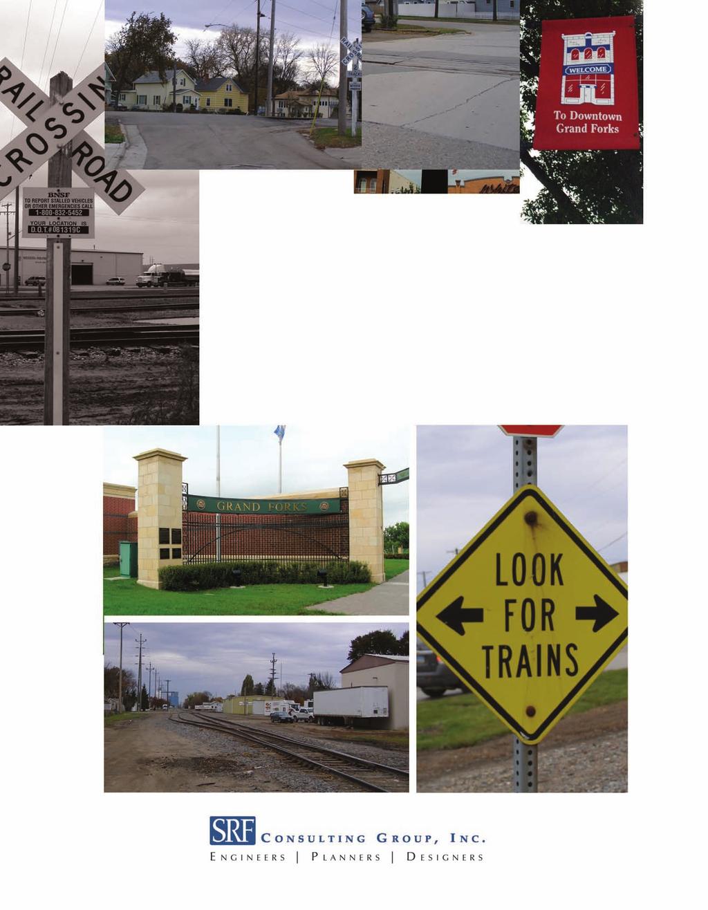
GRANDFORKS MILSPURFEASIBILITYSTUDY. GrandForksandEastGrandForksMPO. FINALReport. August2010
|
|
|
- Briana French
- 5 years ago
- Views:
Transcription

1 GRADFORKS MILSPURFEASIBILITYSTUDY GrandForksandEastGrandForksMPO FIALReport August2010
2 Table of Contents Chapter 1: Introduction and Background... 1 Chapter 2: Existing Conditions and Issues Identification Existing Railroad/Roadway characteristics Existing Access Issues Pedestrian/bicycle crossings and Safe Routes to School Truck, City bus, and school bus routes Emergency responder routes Crash analysis Related Studies... 8 Chapter 3: Public Participation Process Field Review Meeting eighborhood Committee Public Meetings Local government presentations Project Website Chapter 4: Mill Spur Improvement Concepts Agency Input Preliminary Safety Improvements Impact Evaluation Preferred Alternative Safety Improvements Crossing Closure Impacts Preferred Improvement Cost Estimates Chapter 5: Conclusions and Implementation Phasing of Proposed Improvements Potential Funding Sources Figures Figure 1: Mill Spur Study Corridor... 2 Figure 2: Bus and Truck Routes... 7 Figure 3: Segment 1 Preliminary Improvements Figure 4: Segment 2 Preliminary Improvements Figure 5: Segment 3 Preliminary Improvements Figure 6: Preferred Alt Improvements Figure 7: Preferred Alt Improvements Figure 8: Preferred Alt Improvements Figure 9: Preferred Alt Improvements Figure 10: Crossing Closure Traffic Volume Distribution i
3 Tables Table 1: Existing Crossing Data... 3 Table 2: Crash Analysis... 8 Table 3: Proposed Improvements and Impacts Table Table 4: Preliminary Cost Estimates for Preferred Alternatives Appendices Appendix A: Issue Maps Appendix B: Crossing Inventories Appendix C: Unit Train Analysis Appendix D: Field Review Meeting and Other Agency Input Appendix E: eighborhood Committee Meetings Appendix F: Public Input Meetings Appendix G: Local Government Meetings Appendix H: Preliminary Cost Estimates Appendix I: Truck Turning Analysis ii
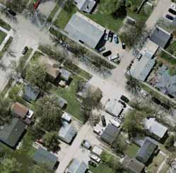
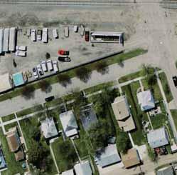
4 Chapter 1: Introduction and Background The Grand Forks/East Grand Forks Metropolitan Planning Organization (GF/EGF MPO) retained SRF Consulting Group, Inc. to conduct a feasibility study of the Mill Spur rail line from 2 nd Avenue orth to Gateway Drive (US Highway 2). The study corridor is shown in Figure 1. The Mill Spur rail line currently handles two trains per day transporting goods from the Grand Forks Rail Yard to the orth Dakota Mill. This study includes ten vehicle crossings and one pedestrian only crossing of the Mill Spur rail line. The crossings from south to north that were reviewed as part of this study include: 2 nd Avenue orth University Avenue Public Alley Crossing (Between University and 4 th Avenue) 4 th Avenue orth 5 th Avenue orth 6 th Avenue orth 7 th Avenue orth 8 th Avenue orth 10 th Avenue orth Gateway Drive Multi Use Trail (Just north of Gateway Drive) The purpose of this study is to identify railroad crossing improvements to improve the overall safety and aesthetics of the corridor, improve traffic operations, and plan for improvements that would accommodate a future train whistle quiet zone. Of the ten vehicle crossings, none have vehicle gates, and train detection is only present at the Gateway Drive crossing. It is unusual for this many unprotected crossings to exist in a neighborhood; however, the lack of active warning devices at rail crossings has not been problematic, because of low train and vehicle volumes. One of the driving factors for this study is the potential of increased train lengths and frequency to meet the orth Dakota Mill s increasing needs. In addition, the Mill Spur rail line also bisects school boundaries, truck and bus routes, and is frequently crossed by emergency responders. This study identifies existing conditions and safety issues along the corridor, alternative improvements that were developed for the railroad corridor and crossings, potential impacts and preliminary costs for the various improvement alternatives, a preferred improvement for each crossing and corridor segment, and a plan to implement the improvements over time. Further, it was also noted that the length and frequency of trains along this corridor is anticipated to increase. This, along with the potential for trains traveling through the neighborhood at night and the associated train horn noise may become problematic for the neighborhood. In order to address these issues, the minimum requirements at each crossing that would be needed to implement a future whistle free quiet zone were also identified as part of this study. Mill Spur Feasibility Study 1 August 2010
5 d R r Mill Rd CAADA!? 20th St O R T H D A K O T A Study Area City of Grand Forks Red Dot Pl Alpha Ave MI. 19th St W 20th St W E a s t G r a n d F o r k s ForrestCt W R e River Rd W 18th St W 17th St W Rd SOUTH DAKOTA 6th St i v Conklin Ave e Fenton Ave 26th St Campus Rd Gateway Dr 22nd Ave G r a n d F o r k s 22nd St 23rd St 21st St Washington St 13th Ave!>!? STUDY AREA 11th Ave 10th Ave Seward Ave!? 9th Ave 8th Ave 19th St 14th St Dyke Ave 7th Ave!?!? 6th Ave 5th Ave!? 4th Ave!? University Ave 2ndAve 1st Ave!?!?!?!? )g 4th St 5th St Washinton 7th St 8th St Cherry St Gateway Dr W 1st Ave 2nd Ave S J:\Maps\6951A\mxd\Figure1.mxd ers Ave Study Area!> Pedestrian Crossing Railroad Crossing!? DeMers S Frontage Rd Grand Forks Mill Spur Feasibility Study Grand Forks-East Grand Forks MPO St 5th Ave S 0 1,000 2,000 Feet Figure 1
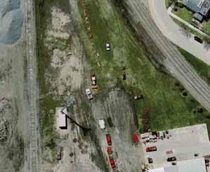
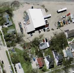
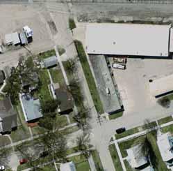
6 Chapter 2: Existing Conditions and Issues Identification The existing conditions and issues for the rail corridor were identified through an examination of crossing inventory data; accident history data; field review meetings; agency input; study review committee (SRC) meetings; neighborhood committee (C) meetings; public input meetings (PIM); review of truck, school, pedestrian, bicycle, bus, fire, and police routes; and technical analysis. The existing conditions and issues that were identified served as the basis for developing alternatives and potential impacts from the alternatives. In particular issues were identified for the potential of closing crossings as a safety improvement. A series of figures identifying access issues at each of the crossings is included in Appendix A. 2.1 Existing Railroad/Roadway characteristics There are currently two trains per day traveling on the Mill Spur rail line, between the Grand Forks Rail Yard to the orth Dakota Mill. The rail line crosses 10 vehicle crossings and one multi-use trail crossing within the study area. Typical train speeds along the Mill Spur rail line through the study area vary between one and 10 mph. The land use along the Mill Spur rail corridor is predominately residential in nature between 2 nd Avenue orth and 8 th Avenue orth and Commercial/Industrial from 8 th Avenue orth to Gateway Drive. Second Avenue orth and Eighth Avenue orth are both classified as collector roadways, University Avenue is classified as a minor arterial, Gateway Drive is classified as a principal arterial, and the remaining crossing streets are all classified as local streets. Table 1 identifies each of the rail crossings, the average daily traffic (ADT) volumes at each, the number of traffic lanes, and the existing crossing control/safety features at each crossing. Appendix B includes the United States Department of Transportation (US DOT) inventories for each crossing. Table 1: Existing Crossing Data US DOT Crossing umber Street ame Vehicle Gates (Yes/o) Average Daily Traffic (Year) umber of Traffic Lanes Train Detection S 2nd Avenue orth o 1,100 (2005)* 2 one Y University Avenue o 5,600 (2005)* 2 one F Public Alley Crossing o 50 (1988)* 2 one M 4th Avenue orth o 500 (2009)** 2 one G 5th Avenue orth o 700 (2005)* 2 one th Avenue orth o 820 (2009)** 2 one V 7th Avenue orth o 510 (2009)** 2 one C 8th Avenue orth o 2,100 (2005)* 2 one R 10th Avenue orth o 1,825 (2005) 2 one E Gateway Drive US Highway 2 o 21,115 (2008)* 4 DC/AFO * Traffic Count Data from FRA Inventory Forms ** Traffic Count Data from 2009 Turning Movement Counts. Peak Hour assumed to be 10% of ADT. Mill Spur Feasibility Study 3 August 2010
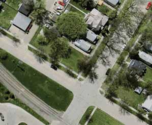
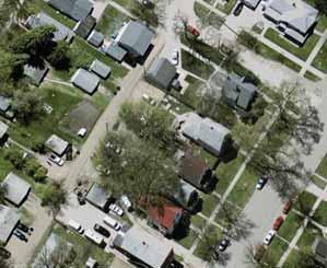
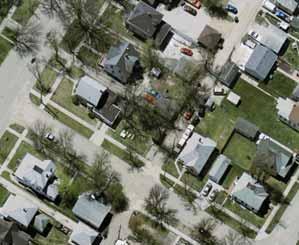
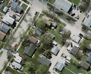
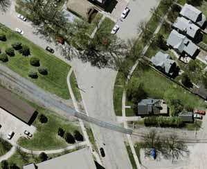
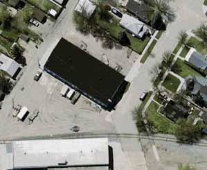
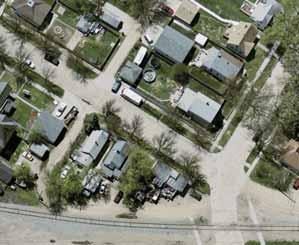
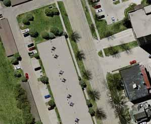
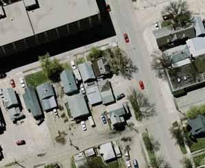
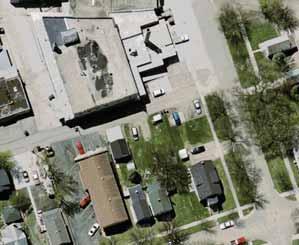
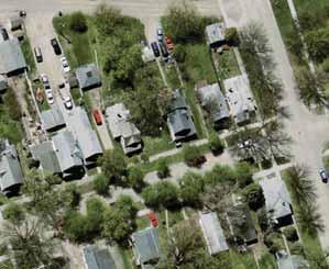
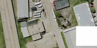
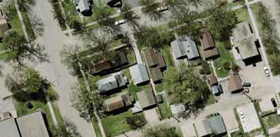
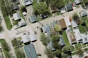
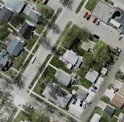
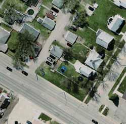
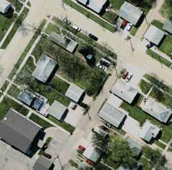
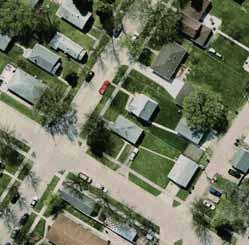
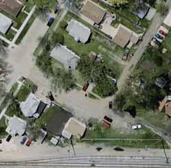
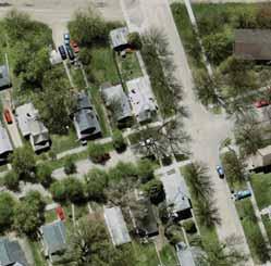
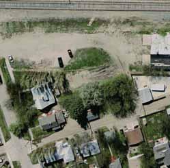
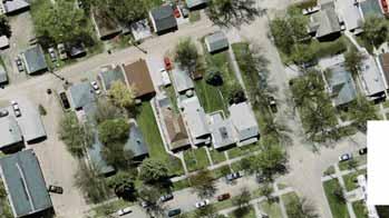
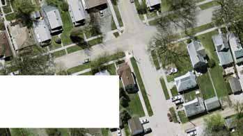
7 2.2 Existing Access Issues During the field review it was noted that many of the crossings have driveways or street access located within 100 feet of the crossing. This creates a crossing safety issue and limits potential for possible safety measures, such as two quadrant vehicle gates with non-traversable medians. According to the Federal Railroad Administration (FRA), the standard length for a median is 100 feet. There are exceptions to reduce the median length if there is an intersecting roadway within close proximity to the crossing. If an existing roadway access point falls within the length of a proposed median, vehicle movements would be limited to right-in/right-out only. This creates a situation where vehicles may be tempted to travel in the wrong direction on the roadway, around the median, in order to make left-turn movements or to weave through vehicle gate arms when they are down. The potential access issues identified at each crossing are listed below: 2 nd Avenue orth: orth 10 th Street is located approximately 65 feet west of the tracks. Two business accesses are located approximately 20 feet east of the tracks on both sides of 2 nd Avenue orth (Figure 1, Appendix A). University Avenue: orth 10 th Street is located approximately 80 feet southwest of the tracks and forms a skewed intersection with University Avenue. There is a driveway access immediately west of the crossing (Figure 2, Appendix A). Public Alley Crossing (Between University and 4 th Avenue): This crossing serves as a connection between the business (Dick Walsh Construction) on the east and west sides of the railroad tracks. There is a public roadway and a driveway serving a private business on the east side of the crossing, and a public alleyway and private parking lot immediately west of the crossing. In addition, there is a building immediately adjacent to the tracks in the northeast quadrant of the crossing, which limits sight lines (Figure 2, Appendix A). 4 th Avenue orth: There are alleyways immediately adjacent to the tracks at the northeast and southwest quadrants of the crossing, with no curb or landscaping between them. Garages for residential homes face the alleyway on the northeast side of the tracks. A business is using the alley as a roadway access on the southwest side of the tracks. A driveway is located approximately 50 feet southwest of the tracks. In addition, the curb line on the south side of 4 th Avenue orth, east of the crossing is damaged and worn (Figure 3, Appendix A). 5 th Avenue orth: An alleyway is immediately adjacent to both sides of the tracks with no curb or landscaping between them. Garages for residential homes face the alleyway on both sides of the tracks. 11 th Street orth is located approximately 50 feet southwest of the tracks and forms a skewed intersection with 5 th Avenue orth. A residential driveway is located approximately 35 feet northeast of the tracks on the south side of 5 th Avenue orth (Figure 4, Appendix A). 6 th Avenue orth: An alleyway is immediately adjacent to the west side of the tracks with no curb or landscaping between them. Garages for residential homes face the alleyway. A public street is located approximately 40 feet east of the tracks on the south side of 6 th Avenue orth (Figure 5, Appendix A). Mill Spur Feasibility Study 4 August 2010
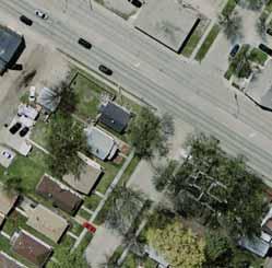
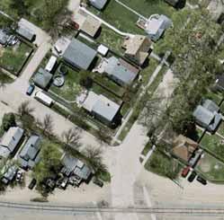
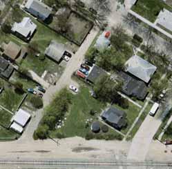
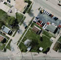
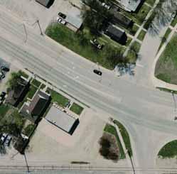
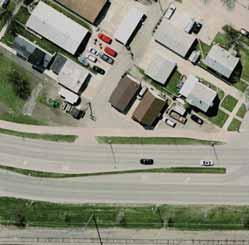
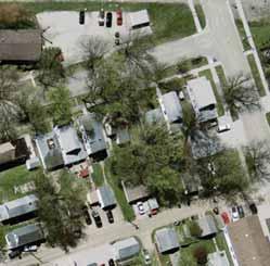
8 7 th Avenue orth: An alleyway is immediately adjacent to both sides of the tracks with no curb or landscaping between them. Garages for residential homes face the alleyways. A residential driveway is located approximately 80 feet west of the tracks on the south side of 7 th Avenue orth. A commercial driveway and public street are located approximately 60 feet east of the tracks. In addition, the curbs on both sides of 7 th Avenue orth, east of the crossing, are worn and damaged (Figure 6, Appendix A). 8 th Avenue orth: An alleyway is immediately adjacent to the east side of the tracks with no curb or landscaping between them. Washington Street is located approximately 60 feet west of the tracks. An additional alley access and a public street are both located approximately 80 feet east of the tracks. In addition, the curbs on both sides of 8 th Avenue orth, east of the crossing, are worn and damaged (Figure 7, Appendix A). 10 th Avenue orth: Washington Street is located approximately 40 feet west of the tracks. A driveway access is located approximately 40 feet east of the tracks on the south side of 10 th Avenue orth. In addition, the curb on both sides of 10 th Avenue orth, east of the crossing, are worn and damaged (Figure 8, Appendix A). Gateway Drive: An alleyway is immediately adjacent to the east side of the tracks with no curb or landscaping between them. Mill Road is located approximately 50 feet east of the tracks and is skewed to Gateway Drive. The free southbound to westbound right turn lane on Mill Road creates a safety issue because it is not protected by the signal. The current railroad cantilever and lights at the crossing are being blocked by a traffic signal in the westbound direction of the Gateway Drive and Mill Road intersection. Washington Street is located approximately 230 feet west of the tracks. Both the Washington Street and Mill Road intersections with Gateway Drive are signalized and there have been issues with vehicles stopping on the tracks at this location (Figure 9, Appendix A). 2.3 Pedestrian/bicycle crossings and Safe Routes to School It is important to consider pedestrian safety as well as vehicle safety when applying safety improvements to a railroad crossing and corridor. Pedestrian crossing facilities are present at all of the crossing locations with the exception of 10 th Avenue orth. At 2 nd Avenue orth there is a sidewalk crossing on the north side of the roadway only, and at 8 th Avenue orth there is a sidewalk only on the south side of the roadway. The remaining crossings (with the exception of 10 th Avenue) have pedestrian sidewalks on both sides of the roadway. At most of the crossings along the corridor, the sidewalks in the area of the railroad crossing are worn or damaged, and in need of maintenance or repairs. In addition to the sidewalks at each crossing, there is currently a trail approximately 250 feet north of the Gateway Drive (Highway 2) vehicular crossing, which crosses the Mill Spur line. This trail crossing is designated as a multi-use, off street paved path on the City of Grand Forks 2009 Bike Map. The path was also noted as a snowmobile trail at the field review meeting. This crossing is currently signed with stop and look for trains signs on the eastbound approach of the crossing (Figure 10, Appendix A). Mill Spur Feasibility Study 5 August 2010
9 According to the Grand Forks Safe Routes to School Maps University Avenue, 4 th Avenue orth, 5 th Avenue orth, and 6 th Avenue orth are designated safe routes to school across the Mill Spur rail line. These identified safe routes serve both the St. Michaels and Winship Elementary Schools. 2.4 Truck, City bus, and school bus routes Second Avenue orth, 10 th Avenue orth, and Gateway Drive have all been identified as designated truck routes crossing the Mill Spur rail line. Both Washington Street and Mill Road which parallel the Mill Spur rail line are also designated truck routes. The local transit service, know as Cities Area Transit (CAT) has designated transit bus routes at University Avenue, 5 th Avenue orth, 8th Avenue orth, and Gateway Drive across the Mill Spur rail line. These include CAT Routes two, four, and six. Figure 2 illustrates the designated truck and bus routes within the study area. In addition, buses serving the St. Michaels Elementary, Winship Elementary, Wilder Elementary, and Central High Schools cross the Mill Spur rail line. Buses cross at each of the public vehicle crossings identified in this study during both the morning and afternoon periods, Monday through Friday. The highest frequency of school bus crossings occurs at the Gateway Drive and 10 th Avenue orth crossings, as these routes are used by many buses that service Central High School. 2.5 Emergency responder routes The Grand Forks Police and Fire departments regularly cross the Mill Spur rail line for emergency service. Both the police and fire departments have indicated that although emergency response vehicles do cross the rail line, the potential crossing closures identified by this study would not have a major impact on police and fire response times, as there are suitable alternative routes along the corridor. In the event of a closure at any of these crossings, emergency responders would need to identify alternative routes to cross the Mill Spur rail line. Mill Spur Feasibility Study 6 August 2010
10 Wa sh in t on 17 th St 1 8th St 16 th 2 0th St St St Av e 11 th 12 th Av e Av e Av e GRAD FORKS t 7th Av e Av e 6th Av e Av e Av e 4th 8th?! Washington St?!?!?!?!?!?!?! Mill Rd 5 t th S ay h St 7t Av e t th S ar d 6 4 t th S ve 1st Ave Se w 5t h Truck and Bus Routes 3 Mill Spur Crossings CAT Bus Routes Truck Routes t rd S 2n ds t Feet University Avenue, 4th Avenue orth, 5th Avenue orth and 6th Avenue orth are designated Safe Routes to School.?! St 5th Fe nto na rs Ave D eme Figure 2 Grand Forks Mill Spur Feasibility Study St Grand Forks - East Grand Forks MPO 4th J:\Maps\6951A\mxd\FigureX_GF_RR Xings.mxd Ga h St 8t Dr St 9th tew hin gt on S?! Un ive?! th St ya ve 10 St St rsit 11 th St 5th 12 th 15 th 13 th Wa s th St 10 th 14 9th 1s t Av e Av e Dy ke Av e
11 2.6 Crash analysis Historically there have been very few automobile/train crashes along the Mill Spur rail line. There have been no crashes reported since Of the past crashes, none have resulted in fatalities and only one has resulted in an injury. The crossings with the highest frequency of crashes are Gateway Drive and University Avenue, with 12 and 8 crashes respectively. This may be explained by the fact that these roadways have the highest ADT volumes, resulting in the most automobile/train exposures. Table 2 summarizes the crash history of each crossing. Table 2: Crash Analysis DOT UMBER ROADWAY CRASH HISTORY S Y M 2nd Avenue University Avenue 4th Avenue 3 crashes total, no crashes since 1993, no fatalities or injuries (property damage crashes only) 8 crashes total, no crashes since 2002, no fatalities, one injuries 2 crashes total, no crashes since 1987, no fatalities or injuries (property damage crashes only) G 5th Avenue o crashes th Avenue 1 property damage crash in V C 7th Avenue 8th Avenue 2 crashes total, no crashes since 1986, no fatalities or injuries (property damage crashes only) 2 crashes total, no crashes since 1998, no fatalities or injuries (property damage crashes only) R 10th Avenue 1 property damage crash in E Gateway Drive (US Highway 2) Source: FRA Highway-Rail Grade Crossing Accident Reports 12 crashes total, no crashes since 1994, no fatalities or injuries (property damage crashes only) 2.7 Related Studies Other studies were completed previously to and concurrently with the Mill Spur Feasibility Study. These studies include the orth eighborhood Vision Study, the Grand Forks and East Grand Forks Quiet Zone Analysis and the Bacon Road Study. The orth eighborhood Vision Study was conducted by a neighborhood group in north Grand Forks, prior to this study. As part of a visioning exercise, the group of neighborhood resident identified the Mill Spur railroad corridor as the ugliest part of their neighborhood. They also identified pedestrian safety and train horn noise as key problems in this area. Improvements proposed by the group include improving pedestrian rail crossings to address handicapped accessibility, adding decorative lighting, and planting grass near the crossings where vegetation appears to have eroded away. Another improvement to pedestrian safety as identified by the neighborhood residents would be to screen the rail corridor. The committee expressed a preference for vegetative screening rather than a structured screening such as a wall or fence. Mill Spur Feasibility Study 8 August 2010
12 The Bacon Road study was conducted by SRF Consulting Group, Inc. concurrently with the Mill Spur study. The study was driven by three main factors: 1) the increased number of vehicles and train creates a greater concern for safety; 2) a new BSF operating procedure that requires a 250 sight distance buffer reduces the mills rail car storage by 16 vehicles in their yard; and 3) the potential expansion of the orth Dakota Mill which may result in the increase of the current number of train movements and the potential for larger unit trains to deliver grain to their facility. The Bacon Road study was being conducted to determine the effects of closing the Bacon Road across at Mill Spur rail line along with other possible alternatives. During a stakeholders meeting to identify issues for the Bacon Road Study, it was noted that the unit train could go in excess of 7,000 feet long, much longer than the existing trains traveling on the Mill Spur rail line. It was also noted at the stakeholders meeting that the unit train would arrive approximately once a week at any time of day or night. This could result in the train traveling through Mill Spur study area during peak traffic times or at night when residents are sleeping. o trains currently travel along the Mill Spur rail line at night. A technical analysis was completed to determine how a unit train would affect the crossings between 2 nd Avenue orth and Gateway Drive. The results of the analysis indicate that each individual crossing would be blocked for a total of minutes or 8.67 minutes, assuming train speeds 5 mph and 10 mph respectively; all of the crossings within the Mill Spur study area would be blocked at the same time for 5.17 minutes or 2.97 minutes, respectively; and the total for a train to pass through the Mill Spur study area blocking at least one of the crossings is minutes or minutes respectively. Although significant improvement would be required to implement unit trains the study committee felt it was important to consider these possible impacts. A technical memorandum entitled Mill Spur Feasibility Study Unit Train Crossings Blocked Analysis, dated April 2, 2010, documents this analysis and is attached in Appendix C. The Grand Forks and East Grand Forks Quiet Zone analysis was conducted by SRF Consulting Group, Inc. concurrently with the Mill Spur study. The analysis was conducted to determine the safety improvements that would need to be implemented in order to create a 24-hour whistle free quiet zone in East Grand Forks, Downtown Grand Forks, West Grand Forks, the Glasston subdivision, and the Hillsboro subdivision. The results of this analysis do not directly affect the Mill Spur Feasibility Study. However, it is important to note that as these quiet zones are implemented within the City of Grand Forks, train horns will continue to blow at the Mill Spur rail line crossings. Mill Spur Feasibility Study 9 August 2010
13 Chapter 3: Public Participation Process Public participation was a key component in the process of identifying issues and opportunities, and collecting stakeholder input on alternatives for this study. The various forms of public participation included a study review committee (SRC) that met for a field review meeting, a neighborhood committee (C), and public input meetings (PIM). 3.1 Field Review Meeting A field review meeting was held on October 27, 2009, with the project s SRC. The SRC included representatives from FRA, BSF, DDOT, GF/EGF MPO, City of Grand Forks, the Grand Forks Police Department, and SRF Consulting Group, Inc. The purpose of the field review meeting was to walk along the Mill Spur rail corridor to identify issues and potential safety improvements at the crossings and along the rail line. Prior to this study an agency field diagnostic of the Mill Spur rail line had been conducted with FRA, BSF, DDOT, GF/EGF MPO and the City of Grand Forks to identify safety improvements; prioritize the crossings needs for active warning systems (vehicle gates, flashers, and train detection); and identify crossings that would be candidates for crossing closures with the least impact to traffic circulation. The results of the agency field diagnostic were discussed at the Mill Spur field review. The Mill Spur field review is the only time that the SRC met as a single group. The SRC committee was invited to all future neighborhood committee and public input meetings. An agenda and meeting summary of the field review are attached to this document in Appendix D. 3.2 eighborhood Committee The neighborhood committee met three times during the study process. Members of the C included representation from the Grand Forks City Council, neighborhood residents, businesses, schools, and emergency responders. The first C meeting was held on ovember 19, 2009, to identify issues at the crossings and along the corridor. The second C meeting was held on February 23, At this meeting the committee was asked to comment on the proposed crossing improvement alternatives, along with some sub alternatives that were developed to address the identified issues along the corridor. The third meeting was held on June 1, 2010, to review and make final comments on the preferred improvements that were developed for the corridor and provide comments on the draft feasibility study. The agendas, meeting summaries, and meeting material are attached to this document in Appendix E. Mill Spur Feasibility Study 10 August 2010
14 3.3 Public Meetings Two public input meetings were held during the study process. The public input meetings were advertised through direct mailings to SRC and C members, notices in the Grand Forks Herald, a notice on the project website, and a press release. The first PIM was held on February 23, The purpose of the meeting was to discuss the issues identified along the Mill Spur and collect input on the preliminary alternative(s) for safety improvements along the Mill Spur Line. The second PIM was held on June 1, 2010, to review and make final comments on the preferred improvements that were developed for the corridor and provide comments on the draft feasibility study. The meeting summaries, meeting materials, and sign in sheets are attached to this document in Appendix F. 3.4 Local government presentations To be held at the end of the project. Include meeting minutes in Appendix G. 3.5 Project Website The GF/EGF MPO administered a website for the project. Links for the project information were located on GF/EGF MPO main web page at The website was updated at various stages throughout the project identifying project issues, showing preliminary alternatives, advertising upcoming project meetings, and offering the general public a chance to comment on the project. Mill Spur Feasibility Study 11 August 2010
15 Chapter 4: Mill Spur Improvement Concepts 4.1 Agency Input As discussed in Section 3.1, prior to this study an agency field diagnostic of the Mill Spur rail line had been conducted with FRA, BSF, DDOT, GF/EGF MPO and the City of Grand Forks. The purpose of this meeting was to identify safety improvements, prioritize the crossings needs for active warning systems (gates, flashers, and train detection), and identify crossings that would be candidates for crossing closures with the least impact to traffic circulation. Results from this early meeting indicated that the Mill Spur crossings with the public alley (between University and 4 th Avenue), 4 th Avenue orth, 6 th Avenue orth, 7 th Avenue orth, and 10 th Avenue orth would make good candidates for potential crossing closures. The committee also prioritized Mill Spur crossings for installation of safety improvements including constant warning time detection, gates, and flashers as funding becomes available. The priority of safety improvements from highest to lowest priority is as follows: University Avenue, 5 th Avenue orth, 8 th Avenue orth and 2 nd Avenue orth. Gateway Drive was not included in this original study and therefore was not prioritized for crossing upgrades as part of the agency meeting. It was later discussed at the field review meeting on October 27, 2009, that 10 th Avenue orth would not be a candidate for a crossing closure since it is part of the City s truck route system. Instead, 10 th Avenue orth should be added to a list for safety improvements including constant warning time, gates, and flashers. 4.2 Preliminary Safety Improvements The preliminary safety improvement concepts for the Mill Spur corridor study area were developed based on agency input and the issues identified early in the study process (see Chapter 2). A typical crossing safety improvement recommendation is a two-quadrant railroad vehicle gates with raised medians. This safety improvement channelizes the vehicles on the correct side of the median behind the safety gate when a train is present and eliminates the ability of vehicles to weave between the gates. The raised medians will all be a minimum of eight inches in height and a minimum of two feet wide. The length of the raised medians varies by location. The desirable length of the medians is 100-feet; however, the length of the medians is often less than 100-feet in order to reduce impacts to nearby roadway access points such as intersecting streets and driveways. Installation of the raised medians often requires relocation or closure of driveways that would exist within the median, particularly if the driveway is located on the unprotected side of the median or the side of the median where there is no vehicle gate arm. On street parking will be eliminated in locations adjacent to and approaching the raised medians. The medians are recommended for safety; however, given the low volume of vehicles and trains along the Mill Spur corridor, medians may not be required for future implementation of a quiet zone. Another typical safety improvement proposed is the installation of pedestrian mazes. The pedestrian mazes will be ADA compliant and force a bicyclist or pedestrian to look both ways down the tracks as they go through the maze before crossing. Fencing along the railroad corridor is another safety improvement that has been proposed. The purpose of fencing the rail corridor is to discourage railroad trespass and force pedestrians to cross at designated areas, and to screen Mill Spur Feasibility Study 12 August 2010
16 the railroad corridor from the neighborhood in an effort to aesthetically enhance the neighborhood. The fencing would be a vinyl coated fence for the first 100-feet from the crossing and would tie into either the gate arm or pedestrian mazes. After the first 100-feet, the fencing will transition into a vegetative landscape barrier. This was desired by the neighborhood to enhance the Mill Spur corridor. During a meeting with BSF, it was noted that red or orange colored fencing or plantings should be avoided so that it does not limit the effectiveness of similar colored safety equipment. The preliminary improvement concepts for each crossing and the overall corridor are described below and are shown in Figures 3, 4 and 5. Rails with Trails: An 8- to 10-foot wide multi-purpose trail that would run parallel to the Mill Spur Rail line was discussed during the field review meeting. The GF-EGF MPO noted that this concept, know as Rails with Trails has been identified as a multi-use trail for the City of Grand Forks. This concept was noted on the preliminary improvement layouts. 2 nd Avenue orth: Preliminary safety improvements proposed at 2 nd Avenue orth include installation of two-quadrant railroad vehicle gates, constant warning time, raised medians, pedestrian mazes, relocation of two driveways, and adding fencing/plantings along the railroad corridor. The raised median would be 45-feet in length on the west side of the crossing and 60- feet in length on the east side of the crossing. The relocation of the two driveways for one business and one apartment building on the east side of the crossing is to move them further east so they are not located within the 60-foot long median. The pedestrian mazes are proposed to be installed along the north side of 2 nd Avenue where sidewalk currently exists. Fencing is proposed north of the crossing along the west side of the railroad corridor. University Avenue: Preliminary safety improvements proposed at University Avenue include, installation of two-quadrant railroad vehicle gates, constant warning time, raised medians, pedestrian mazes, realignment of 10 th Street orth in the southwest quadrant, and adding fencing/plantings along the railroad corridor. The raised median would be 100-feet in length on the west side of the crossing and 60-feet in length on the east side of the crossing. The realignment of the 10 th Street orth in the southwest quadrant is to intersect the street with University Avenue at a more perpendicular angle. The addition of the median on the west side would limit turning movements at the University Avenue and 10 th Street orth intersection to right-in/right-out only. The pedestrian mazes are proposed to be installed along both sides of University Avenue since pedestrian facilities exist on both sides of the street. Fencing is proposed both north and south of the crossing along the west side of the railroad corridor. Public Alley Crossing (Between University and 4 th Avenue): The public alley crossing is an alleyway located between University and 4 th Avenue orth. The alley serves as a connection between two buildings for the Walsh Construction business. However, the crossing is open to the public. Preliminary safety improvements proposed at the public alley crossing include installation of stop signs at the crossing and the addition of curb along the parking lot in the northwest quadrant of the crossing. The purpose of the curb is to keep vehicles from driving too close to the railroad tracks at this location. A second option to close the public alley crossing was brought up during later public input meetings and is further discussed in Section 4.4 of this report. Mill Spur Feasibility Study 13 August 2010
17 4 th Avenue orth: Preliminary safety improvements proposed at 4 th Avenue orth include closing the roadway and pedestrian crossing, constructing a cul-de-sac on the east side of the crossing, placing curb along the west and southwest sides of the crossing, placing curb on the south side of 4 th Avenue orth on the east side of the crossing, and adding fencing/plantings at the crossing closure and along the corridor. A second option to keep this crossing open and implement safety improvements was brought up during later public input meetings and is further discussed in Section 4.4 of this report. 5 th Avenue orth: Preliminary safety improvements proposed at 5 th Avenue orth include, installation of two-quadrant railroad vehicle gates, constant warning time, raised medians, pedestrian mazes, placing curb along 5 th Avenue, replacing sidewalk leading up to the crossing, and adding fencing/plantings along the railroad corridor. The raised median would be 40-feet in length on the west side of the crossing and 100-feet in length on the east side of the crossing. The new curb along 5 th Avenue orth will eliminate alley access at this crossing. It has been verified that alternative access is available for the alley traffic on both the north and south side of 5 th Avenue. The pedestrian mazes are proposed to be installed along both sides of 5 th Avenue since pedestrian facilities exist on both sides of the street. Fencing is proposed both north and south of the crossing along the east and west side of the railroad corridor. 6 th Avenue orth: Preliminary safety improvements proposed at 6 th Avenue orth include closing the roadway and pedestrian crossing and adding fencing/plantings along the railroad corridor. 7 th Avenue orth: Preliminary safety improvements proposed at 7 th Avenue orth include closing the roadway and pedestrian crossing and adding fencing/plantings along the railroad corridor. Mill Spur Feasibility Study 14 August 2010

18 Support/6951 GF EGF Railroad Crossing Study/Figures Job # 6951 Date 04/23/10 Preliminary Improvement Concept - Segment 1 Grand Forks Mill Spur Feasibility Study Grand Forks - East Grand Forks MPO Figure 3
19 8 th Avenue orth: Preliminary safety improvements proposed at 8 th Avenue orth include installation of two-quadrant railroad vehicle gates, constant warning time, raised medians, pedestrian mazes, placing curb along 8 th Avenue, replacing sidewalk leading up to the crossing, and adding fencing/plantings along the railroad corridor. The raised median would be 40-feet in length on the west side of the crossing and 45-feet in length on the east side of the crossing. The new curb along the south side of 8 th Avenue orth will eliminate one driveway access. However, the property has an alternative access onto 7 th Street orth. The pedestrian mazes are proposed to be installed on the south side of 8 th Avenue since pedestrian facilities only exist along the south side of the roadway. Fencing is proposed on both the east and west side of the railroad corridor south of 8 th Avenue and only on the east side of the railroad corridor north of 8 th Avenue. 10 th Avenue orth: Preliminary safety improvements proposed at 10 th Avenue orth include installation of two-quadrant railroad vehicle gates, raised medians, placing curb along 10 th Avenue, and adding fencing/plantings along the railroad corridor. The raised median would be 25-feet in length on the west side of the crossing and 35-feet in length on the east side of the crossing. The new curb along the south side of 10 th Avenue on the east side of the crossing will eliminate one driveway access. However, the property has an alternative access onto 6 th Street orth. o pedestrian facilities currently exist at this crossing. However, local agencies have identified the need for adding a sidewalk along the north side of 10 th Avenue orth at this crossing. A sidewalk should be constructed along the north side of this crossing and should connect existing sidewalk along the west side of Washington Street down tie into existing sidewalk to the east along the north side of 10 th Avenue. Pedestrian crossing material will need to be added and pedestrian mazes should be installed on the east and west side of the crossing along the north side of 10 th Avenue. Fencing is proposed on the north and south side of 10 th Avenue along the east side of the railroad corridor. Gateway Drive: Preliminary safety improvements proposed at Gateway Drive include installation of two-quadrant railroad vehicle gates, constant warning time, and active pedestrian gates, raised median, placing curb along Gateway Drive, realignment of 5 th Street orth in the southeast quadrant of the crossing, expansion of the channelization island to accommodate gates for the southbound to westbound right turn on Mill Road, and adding fencing/plantings along the railroad corridor. The raised median would be 100-feet in length on the west side of the crossing only. There is not room for a raised median on the east side between the crossing and the intersection with Mill Road/5 th Street orth. The new curb along the south of 10 th Avenue on the west side of the crossing will eliminate one driveway access. However, this property has an alternative access onto Washington Street. The active pedestrian gates would be placed on both sides of Gateway Drive since sidewalks currently exists along both sides of the roadway. Fencing is proposed on the south side of Gateway Drive along the east side of the railroad corridor. Gateway Drive (Alternative): Alternative safety improvements proposed at Gateway Drive include installation of two-quadrant railroad vehicle gates, constant warning time, and active pedestrian gates, raised medians, placing curb along Gateway Drive, realignment of 5 th Street orth in the southeast quadrant of the crossing, removal of the channelization island at Gateway Drive and Mill Road, relocation of the traffic signal from the channelization island, expansion of Mill Spur Feasibility Study 16 August 2010
20 the curb in the northwest quadrant of the Gateway Drive/Mill Road intersection to accommodate vehicle gates, and adding fencing/plantings along the railroad corridor. The raised median would be 100-feet in length on the west side of the crossing and approximately 15-feet in length on the east side of the crossing. The median would be wider to accommodate railroad vehicle gates. The 15-foot long median on the east side is needed for railroad vehicle gates and will be short in order to allow truck turning movements between Gateway Drive and Mill Road. Placing a railroad vehicle gate and flashers on this island will allow for the removal of the cantilever for westbound Gateway Drive. The existing cantilever is partially covered by the existing westbound traffic signal heads. The new curb along the south of 10 th Avenue on the west side of the crossing will eliminate one driveway access. However, this property has an alternative access onto Washington Street. The active pedestrian gates would be placed on both sides of Gateway Drive since sidewalks exists along both sides of the roadway. Fencing is proposed on the south side of Gateway Drive along the east side of the railroad corridor. Multi-use Trail (orth of Gateway Drive): Preliminary safety improvements proposed at the multi-use trail crossing include installation of Stop and Look for Train signs. An alternative improvement could include installation of flashing lights. A second option to relocate the multiuse trail to utilize the pedestrian improvements at the Gateway Drive crossing was brought up during later public input meetings. Preliminary review of the alternative to relocate the multi-use trail along the north side of Gateway Drive indicates that at maximum only a 4-foot wide trail can fit in between the existing roadway and existing right of way, instead of the 8-foot width that is needed. 4.3 Impact Evaluation The preliminary safety improvements were presented at the second C meeting and first PIM for the study on February 23, Graphics of the preliminary improvements and an impact evaluation matrix for each crossing were presented at both meetings. The impact matrix summarizes the proposed preliminary improvements at each crossing; how the improvements affect crossing and corridor safety; and how the proposed improvements would affect public routes, traffic operations and access management. The impact matrix is shown in Table 3. Mill Spur Feasibility Study 17 August 2010


21 Support/6951 GF EGF Railroad Crossing Study/Figures Job # 6951 Date 04/23/10 Preliminary Improvement Concept - Segment 2 Grand Forks Mill Spur Feasibility Study Grand Forks - East Grand Forks MPO Figure 4
22 Support/6951 GF EGF Railroad Crossing Study/Figures Job # 6951 Date 04/23/10 Preliminary Improvement Concept - Segment 3 Grand Forks Mill Spur Feasibility Study Grand Forks - East Grand Forks MPO Figure 5
23 Table 3 Proposed Improvements and Potential Impacts Crossing 2nd Avenue University Avenue Public Industrial Crossing 4th Avenue 5th Avenue 6th Avenue 7th Avenue 8th Avenue 10th Avenue Gateway Drive Gateway Drive (Alternative) Multi use Trail Proposed Improvements Railroad vehicle gates Raised medians Pedestrian mazes Relocate two driveways Fencing/plantings Railroad vehicle gates Raised medians Pedestrian mazes Realign roadway in southwest quadrant of crossing Fencing/plantings Stop signs Curbing along track (northwest of the crossing) Close roadway and pedestrian crossing Cul de sac on east side of crossing Curbing along track (southwest of the crossing) Curbing on south side of 4th Ave, east of crossing Fencing/plantings Railroad vehicle gates Raised medians Pedestrian mazes Curbing on 5th Ave Fencing/plantings Close roadway and pedestrian crossing Fencing/plantings Close roadway and pedestrian crossing Fencing/plantings Railroad vehicle gates Raised medians Pedestrian mazes Curbing on 8th Ave Fencing/plantings Railroad vehicle gates Raised medians Curbing on 10th Avenue Fencing/plantings Railroad vehicle gates Raised median (west side of crossing only) Active pedestrian gates Realign roadway in southeast quadrant of crossing Curbing on Gateway Drive Expansion of the channelization island (to accommodate 30 foot vehicle gates) Fencing/plantings Railroad vehicle gates Raised medians (short median on east side of crossing) Active pedestrian gates Realign roadway in southeast quadrant of crossing Curbing on Gateway Drive Remove the channelization island/ relocate traffic signal Adjust north curb line (to accommodate 30 foot vehicle gates) Fencing/plantings Stop and look for train signs Flashing lights (alternative) Potential Impacts and Issues Crossing and Corridor Safety Public Routes Traffic Operations and Access Management Improvements will enhance crossing safety for vehicles and pedestrians Fencings/plantings will improve corridor aesthetics and discourage railroad trespass Improvements will enhance crossing safety for vehicles and pedestrians Fencings/plantings will improve corridor aesthetics and discourage railroad trespass Existing residential driveway in northwest quadrant of crossing is a safety concern Improvements will enhance crossing safety Curbing will prevent vehicles from driving on railroad tracks Improvements will enhance crossing safety for vehicles and pedestrians Fencings/plantings will improve corridor aesthetics and discourage railroad trespass Curbing will prevent vehicles from driving on railroad tracks Improvements will enhance crossing safety for vehicles and pedestrians Fencings/plantings will improve corridor aesthetics, provide a buffer between the alley and railroad tracks, and discourage railroad trespass Improvements will enhance crossing safety for vehicles and pedestrians Fencings/plantings will improve corridor aesthetics, provide a buffer between the alley and railroad tracks, and discourage railroad trespass Improvements will enhance safety for vehicles/pedestrians Fencings/plantings will improve corridor aesthetics, provide a buffer between the alley and railroad tracks, and discourage railroad trespass Improvements will enhance crossing safety for vehicles and pedestrians Fencings/plantings will improve corridor aesthetics, provide a buffer between the alley and railroad tracks, and discourage railroad trespass Improvements will enhance crossing safety for vehicles and pedestrians Fencings/plantings will improve corridor aesthetics and discourage railroad trespass Improvements will enhance crossing safety for vehicles and pedestrians Fencings/plantings will improve corridor aesthetics and discourage railroad trespass Improvements will improve crossing safety for vehicles and pedestrians Fencings/plantings will improve corridor aesthetics and discourage railroad trespass Improvements will improve crossing safety Improvements may impact truck movements as 2nd Avenue orth is a designated truck route. Improvements will enhance pedestrian safety as University Avenue is a designated Safe Route to School Improvements may impact bus operations as University Avenue is a bus Route Minimal impacts to connectivity 4th Avenue is a designated Safe Route to School. An alternative route will need to be identified eed to identify alternative routes for emergency responders Improvements will enhance safety/operations for buses as 5th Avenue orth is a bus route Improvements will improve pedestrian safety as 5th Avenue orth is a designated Safe Route to School 6th Avenue is a designated Safe Route to School. An alternative route will need to be identified eed to identify alternative routes for emergency responders eed to identify alternative routes for emergency responders Minimal impacts to connectivity Improvements may impact truck movements as 10th Avenue orth is a designated truck route Improvements may impact truck movements as Gateway Drive is a designated truck route Improvements will enhance safety/operations for buses as Gateway Drive is a bus route Improvements may impact truck movements as Gateway Drive is a designated truck route Improvements will enhance safety/operations for buses as Gateway Drive is a bus route Designated multi use paved path. Improvements will accommodate pedestrians, bikes, and snowmobiles Raised medians may limit trucks turning movements from orth 10th Street to eastbound 2nd Avenue Two driveways east of the crossing will need to be relocated Raised median (west of crossing) will limit access from orth 10th Street to right in/right out only Raised medians (east of crossing) may limit trucks turning movements from driveway/alley east of the crossing to westbound University Avenue Minimal impacts to traffic operations and roadway access Cul de sac east of the crossing will accommodate truck movements eed to determine the type of closure treatment (i.e., planters, 9 button signs, jersey barriers, etc.) Existing traffic on 4th Avenue (500 ADT) will need to be rerouted. This could lead to increased traffic volumes at the Public Industrial crossing, University Avenue, and 5th Avenue crossings. University Avenue and 5th Ave have adequate roadway capacity, but increased traffic at the industrial crossing should be discouraged. Raised medians may limit trucks turning from orth 11th Street to eastbound 5th Avenue orth Alley access within the crossing area will be lost. Alternative access on the west side of the crossing is available via alleys perpendicular to orth 11th and 12th Street and 4th Avenue east of the crossing eed to determine the type of closure treatment (i.e., planters, 9 button signs, jersey barriers, etc.) Existing traffic on 6th Avenue (820 ADT) will need to be rerouted. This could lead to increased traffic volumes on orth 8th Street and at the 5th Avenue crossing. Both have adequate roadway capacity to accommodate this increase in traffic. eed to determine the type of closure treatment (i.e., planters, 9 button signs, jersey barriers, etc.) Existing traffic on 7th Avenue (510 ADT) will need to be rerouted. This could lead to increased traffic volumes on orth 7th Street and at the 8th Avenue crossing. Both have adequate roadway capacity to accommodate this increase in traffic. Raised medians may limit trucks turning movements from orth 7th Street to west bound 8th Avenue orth Driveway access in southeast quadrant of the crossing will be lost. Alternative access is available via orth 7th Street Raised medians will be designed to accommodate truck movements (shortened ease median) Driveway access in the southeast quadrant of the crossing will be lost. Alternative access on is available via orth 6th Street Additional railroad vehicle gate needed in order to protect vehicle movements from southbound Mill Road to westbound Gateway Drive o raised median on east side of the crossing, in order to accommodate truck turning movements Driveway access in the southwest quadrant of the crossing will need to be lost. Alternative access on Washington Street Traffic signal blocking railroad cantilever/flashing lights on westbound approach needs to be adjusted Raised median on east side of the crossing needed in order to accommodate railroad vehicle gates. Median will be short in order to allow truck turning movements Driveway access in the southwest quadrant of the crossing will need to be lost. Alternative access is available on Washington Street Traffic signal will need to be relocated Minimal impacts to traffic operations and roadway access
Salem City Council November 9, 2009
 Salem City Council November 9, 2009 $1.212 million of the $100 million bond was set aside for Railroad Crossing Safety Improvement Projects Construct projects to improve both vehicular and pedestrian safety
FLORIDA DEPARTMENT OF TRANSPORTATION DISTRICT 7 DISTRICT WIDE BICYCLE/PEDESTRIAN ACCESS TO TRANSIT SAFETY ASSESSMENT AND IMPROVEMENT PLAN
 FLORIDA DEPARTMENT OF TRANSPORTATION DISTRICT 7 DISTRICT WIDE BICYCLE/PEDESTRIAN ACCESS TO TRANSIT SAFETY ASSESSMENT AND IMPROVEMENT PLAN TRANSIT SAFETY ASSESSMENT SR 55/US 19 AT 80 TH AVE N DRAFT JUNE
5. RUNNINGWAY GUIDELINES
 5. RUNNINGWAY GUIDELINES These guidelines should be considered collectively when making runningway decisions. A runningway is the linear component of the transit system that forms the right-of-way reserved
Washington St. Corridor Study
 FIGURE 7.17 Bridge Alternatives - Cross Sections 86 Discarded Alternative: Short-Term Bridge Repair Short-term repairs and west bridge span replacement were considered during analysis. Short-term repairs
This page intentionally left blank.
 This page intentionally left blank. COMMUNITY Coweta Community Overview Coweta Coweta, a residential community located in Wagoner County, is a suburb of Tulsa situated southeast of the metropolitan area
TOWN OF CHAPEL HILL POLICY AND PROCEDURES FOR TRAFFIC CALMING MEASURES
 TOWN OF CHAPEL HILL POLICY AND PROCEDURES FOR TRAFFIC CALMING MEASURES (Adopted by the Town Council on June 30, 2004) (Revised December 6, 2010) (Revised February 8, 2016) POLICY AND PROCEDURES FOR TRAFFIC
Report. Typical Sections. City of Middleton, WI
 Report Typical Sections City of Middleton, WI December 2006 Report for City of Middleton, Wisconsin Typical Sections repared by: Traffic Associates LLC and STRAND ASSOCIATES, INC. 910 West Wingra Drive
Pine Hills Road Pedestrian/Bicycle Safety Study Board of County Commissioners Work Session
 Pine Hills Road Pedestrian/Bicycle Safety Study Board of County Commissioners Work Session February 20, 2018 Meeting Agenda Study Overview Existing Conditions Access Management Potential Gateway Features
122 Avenue: 107 Street to Fort Road
 : 107 Street to Fort Road November 24, 2015 4:30 8:00 p.m. Meeting Purpose Summarize project work completed to date Share results of public input from Phase 1 Share the draft concept plan and proposed
4. ENVIRONMENTAL IMPACT ANALYSIS 9. TRANSPORTATION AND TRAFFIC
 4. ENVIRONMENTAL IMPACT ANALYSIS 9. TRANSPORTATION AND TRAFFIC 4.9.1 INTRODUCTION The following section addresses the Proposed Project s impact on transportation and traffic based on the Traffic Study
Item No. 14 Town of Atherton
 Item No. 14 Town of Atherton CITY COUNCIL STAFF REPORT CONSENT AGENDA TO: THROUGH: FROM: HONORABLE MAYOR AND CITY COUNCIL GEORGE RODERICKS, CITY MANAGER MICHAEL KASHIWAGI, COMMUNITY SERVICES DIRECTOR MARTY
Intersection Traffic Control Feasibility Study
 Intersection Traffic Control Feasibility Study CSAH 9 at CSAH 60 (185th Avenue) Prepared For: Dakota County Transportation Department Western Service Center 14955 Galaxie Avenue, 3rd Floor Apple Valley,
5 CIRCULATION AND STREET DESIGN
 5 CIRCULATION AND STREET DESIGN This chapter describes circulation and streetscape improvements proposed for the Northwest Chico Specific Plan Area. It includes detailed design specifications for existing
TRAFFIC ACTION PLAN. Laurie Meadows Neighborhood CITY OF SAN MATEO
 TRAFFIC ACTION PLAN Laurie Meadows Neighborhood CITY OF SAN MATEO Draft January 2017 Table of Contents Introduction... 2 The Traffic Forum Process... 5 Neighborhood Traffic Issues... 7 Neighborhood Recommendations
4.0 ACCESS CONTROL PLAN - SH 14 (JEFFERSON STREET/RIVERSIDE AVENUE)
") 4.1 Existing Conditions Roadway Physical Characteristics Typical Sections Jefferson Street 4.0 ACCESS CONTROL PLAN - SH 14 (JEFFERSON STREET/RIVERSIDE AVENUE) The existing typical cross-section for SH
4.1 Existing Conditions Roadway Physical Characteristics Typical Sections Jefferson Street 4.0 ACCESS CONTROL PLAN - SH 14 (JEFFERSON STREET/RIVERSIDE AVENUE) The existing typical cross-section for SH
EXHIBIT R1. Neighborhood Cul-de-Sac Implementation
 Neighborhood Cul-de-Sac Implementation The traffic study conducted for the Talaria project analyzed the amount of project traffic expected to use local, residential streets immediately north of the project
Dr. M.L. King, Jr. Street North Complete Streets Resurfacing Opportunities HOUSING, LAND USE, AND TRANSPORTATION COMMITTEE MARCH 22, 2018
 Dr. M.L. King, Jr. Street North Complete Streets Resurfacing Opportunities HOUSING, LAND USE, AND TRANSPORTATION COMMITTEE MARCH 22, 2018 What s Happening The City plans to mill and resurface Dr. M.L.
M-58 HIGHWAY ACCESS MANAGEMENT STUDY Mullen Road to Bel-Ray Boulevard. Prepared for CITY OF BELTON. May 2016
 M-58 HIGHWAY ACCESS MANAGEMENT STUDY Prepared for CITY OF BELTON By May 2016 Introduction Missouri State Highway 58 (M-58 Highway) is a major commercial corridor in the City of Belton. As development has
TRANSPORTATION ANALYSIS REPORT US Route 6 Huron, Erie County, Ohio
 TRANSPORTATION ANALYSIS REPORT US Route 6 Huron, Erie County, Ohio December 12, 2012 Prepared for: The City of Huron 417 Main Huron, OH 44839 Providing Practical Experience Technical Excellence and Client
Ann Arbor, Michigan Quiet Zone Assessment
 Ann Arbor, Michigan Quiet Zone Assessment DRAFT FINAL City of Ann Arbor, Michigan February 2019 SRF No. 11295 Table of Contents Executive Summary... iii Introduction... 1 Study Purpose and Background...
Hidden Oaks Elementary School
 Hidden Oaks Elementary School SCHOOL ROUTE PLAN For HIDDEN OAKS ELEMENTARY SCHOOL LOCATION 13 ORANGE COUNTY Prepared for: ORANGE COUNTY SCHOOL ASSESSMENT PROGRAM ORANGE COUNTY PUBLIC WORKS Traffic Engineering
This page intentionally left blank.
 This page intentionally left blank. COMMUNITY Glenpool Community Overview Glenpool Glenpool is a city of nearly 12,000 residents located in Tulsa County southwest of Tulsa and Jenks. The city is growing
7/23/2017 VIA . Michael Hanebutt City of Sacramento Community Development Department 300 Richards Boulevard, 3 rd Floor Sacramento, CA 95811
 7/23/2017 VIA EMAIL Michael Hanebutt City of Sacramento Community Development Department 300 Richards Boulevard, 3 rd Floor Sacramento, CA 95811 RE: 65 th Street Apartments (DR17-220) Dear Mr. Hanebutt:
Clackamas County Comprehensive Plan
 ROADWAYS The County s road system permits the movement of goods and people between communities and regions, using any of a variety of modes of travel. Roads provide access to virtually all property. They
Orange Center Elementary School
 Drag and drop pic and stretch/crop to the limits of the blue rectangle (delete this text box) Orange Center Elementary School Drag and drop pic and stretch/crop to the limits of the blue rectangle (delete
DRAFT - CITY OF MEDFORD TRANSPORTATION SYSTEM PLAN Roadway Cross-Sections
 Roadway Cross-Sections Medford s roadway cross-section standards apply to new and reconstructed roads. The crosssections take into consideration roadway function and operational characteristics, including
HARRISON STREET/OAKLAND AVENUE COMMUNITY TRANSPORTATION PLAN
 HARRISON STREET/OAKLAND AVENUE Community Workshop #4: Draft Plan Review December 3, 2009 D E S I G N, C O M M U N I T Y & E N V I R O N M E N T INTRODUCTIONS Key Project Staff: Alisa Shen, Project Manager,
CITY OF WEST LAKE HILLS. Forest View Neighborhood Traffic Calming Study
 CITY OF WEST LAKE HILLS 901 South Mopac Expressway Building V, Suite 220 Austin, Texas 78746 Texas P.E. Firm Registration No. F-929 Klotz Associates Final Report Submittal: March 20, 2015 Revised Final
NEIGHBORHOOD TRAFFIC CALMING POLICY
 NEIGHBORHOOD TRAFFIC CALMING POLICY I. PURPOSE The City of Kent continually strives to strengthen and protect its neighborhoods by improving the quality of life in residential areas. Traffic conditions
Road Diets FDOT Process
 Florida Department of TRANSPORTATION Road Diets FDOT Process Humberto Castillero, PE, PTOE Roadway Design Office Purpose of Guide Develop a statewide lane elimination review process Balance state & local
ALLEY 24 TRAFFIC STUDY
 ALLEY 24 TRAFFIC STUDY in City of Frostburg, Maryland January 2013 3566 Teays Valley Road Hurricane, WV Office: (304) 397-5508 www.denniscorporation.com Alley 24 Traffic Study January 2013 Frostburg, Maryland
Poor pavement condition Substandard Intersections. / Substandard bike/pedestrian/transit accommodations. Driveway access Environmental concerns
 Public Informational Meeting University Avenue (Allen Boulevard Segoe Road) March 23, 2011 City of Madison City of Middleton Village of Shorewood Hills Dane County Existing Roadway Conditions Poor pavement
Table 1.0 Grade Crossing Enhancements PVL San Jacinto Branch Line
 Grade Crossing Enhancements CPUC 1 2 3 4 5 Citrus Avenue, Riverside County Palmyrita Ave., Columbia Avenue, Marlborough Ave., Spruce St., MP 0.57 002X-0.6 027301Y MP 1.00 002X-1.0 027302F MP 1.24 002X-1.3
Donahue Drive Corridor Traffic Operational Evaluation
 Donahue Drive Corridor Traffic Operational Evaluation PREPARED FOR: THE CITY OF AUBURN PREPARED BY: JANUARY 2007 Donahue Drive Corridor Study--Auburn, Alabama TABLE OF CONTENTS Introduction... 1 Background
ROUTE 81 CORRIDOR STUDY DESIGN CONCEPTS
 RT 81 Corridor Study CLINTON ROUTE 81 CORRIDOR STUDY DESIGN CONCEPTS View north on High Street, with potential improvements to the streetscape Draft Recommendations November 8 th, 2018 TOWN OF CLINTON
Boston Post Road Design Feasibility Study
 Boston Post Road Design Feasibility Study Prepared for the City of Rye Final Report July 18, 2007 Prepared by: Buckhurst Fish & Jacquemart (BFJ) 115 Fifth Avenue New York, NY 10003 www.bfjplanning.com
Meadow Woods Elementary School
 Drag and drop pic and stretch/crop to the limits of the blue rectangle (delete this text box) Meadow Woods Elementary School Drag and drop pic and stretch/crop to the limits of the blue rectangle (delete
Tonight is for you. Learn everything you can. Share all your ideas.
 Strathcona Neighbourhood Renewal Draft Concept Design Tonight is for you. Learn everything you can. Share all your ideas. What is Neighbourhood Renewal? Creating a design with you for your neighbourhood.
Downtown Naples Mobility and Connectivity Study. Naples City Council Presentation January 2017
 Downtown Naples Mobility and Connectivity Study Naples City Council Presentation January 2017 Agenda 1. Introduction 2. Scope Review 3. Project Schedule 4. Existing Conditions 5. Public Charrette 6. Mobility
Los Altos Hills Town Council - June 18, 2015 Palo Alto City Council June 22, AGENDA ITEM #2.B Presentation
 Los Altos Hills Town Council - June 18, 2015 Palo Alto City Council June 22, 2015 AGENDA ITEM #2.B Presentation Previous Presentations Los Altos Hills Town Council in May 2014 and February 2015 Palo Alto
This chapter describes the proposed circulation system and transportation alternatives associated with
 5.0 Circulation 5.1 OVERVIEW This chapter describes the proposed circulation system and transportation alternatives associated with West Landing, and summarize the information contained in the Existing
Preliminary Engineering Study
 Preliminary Engineering Study Open House # 2 June 6, 2018 PREPARED FOR: PREPARED BY: Agenda Background and status of preliminary engineering study County Road 26 design summary County Road 63 design summary
Windy Ridge Elementary School
 Windy Ridge Elementary School SCHOOL ROUTE PLAN For WINDY RIDGE ELEMENTARY SCHOOL LOCATION 54 ORANGE COUNTY Prepared for: ORANGE COUNTY SCHOOL ASSESSMENT PROGRAM ORANGE COUNTY PUBLIC WORKS Traffic Engineering
RZC Appendix 8A Marymoor Subarea Street Requirements
 RZC Appendix 8A Marymoor Subarea Street Requirements For additional design details for Marymoor Subarea infrastructure, refer to the 2017 Marymoor Subarea Infrastructure Planning Report. STREET REQUIREMENTS
Corpus Christi Metropolitan Transportation Plan Fiscal Year Introduction:
 Introduction: The Safe, Accountable, Flexible, Efficient Transportation Equity Act: A Legacy for Users (SAFETEA-LU) has continued the efforts started through the Intermodal Surface Transportation Efficiency
2014/2015 BIKE ROUTE PLAN 83 AVENUE PROTECTED BIKE LANE
 About the Project The City of Edmonton is planning a major bike route on the southside of Edmonton. The Strathcona Bike Route will connect the communities of Strathcona, Garneau and the University area,
Broad Street Bicycle Boulevard Design Guidelines
 Broad Street Bicycle Boulevard Design Guidelines Building from the strategies introduced in the 2013 Bicycle Transportation Plan and community input received thus far, City Transportation Staff have identified
City of Wayzata Comprehensive Plan 2030 Transportation Chapter: Appendix A
 A1. Functional Classification Table A-1 illustrates the Metropolitan Council s detailed criteria established for the functional classification of roadways within the Twin Cities Metropolitan Area. Table
WELCOME. Stakeholder Involvement Group Meeting #2 Round Lake Public Works October 24, 2018
 WELCOME Stakeholder Involvement Group Meeting #2 Round Lake Public Works October 24, 2018 MEETING AGENDA 1. Welcome and Introductions 2. Study Progress Update 3. Problem Statement 4. Technical Analysis
DRAFT. Table of Contents. Background
 Douglas County Table of Contents Existing Infrastructure 86 Funding 89 Policy and Program Recommendations 90 Infrastructure Recommendations 92 Conclusion 95 Background Home to 4,500 residents and Baker
TRAFFIC ACTION PLAN. North Central Neighborhood CITY OF SAN MATEO
 TRAFFIC ACTION PLAN North Central Neighborhood CITY OF SAN MATEO Draft February 2017 Table of Contents Introduction... 1 The Traffic Forum Process... 4 Neighborhood Traffic Issues... 6 Neighborhood Recommendations
Brooklyn Boulevard (County Road 152) Reconstruction Project Phase I. OPEN HOUSE June 20, 2017
 Reconstruction Project Phase I. OPEN HOUSE June 20, 2017") Brooklyn Boulevard (County Road 152) Reconstruction Project Phase I OPEN HOUSE June 20, 2017 Brooklyn Boulevard (County Road 152) Phase I Project Partners Project Lead Other Project Partners include Brooklyn
Brooklyn Boulevard (County Road 152) Reconstruction Project Phase I OPEN HOUSE June 20, 2017 Brooklyn Boulevard (County Road 152) Phase I Project Partners Project Lead Other Project Partners include Brooklyn
BETHEL ROAD AND SEDGWICK ROAD CORRIDOR STUDY
 DRAFT PLAN City Council Meeting August 14, 2017 STUDY AREA Sedgwick Corridor State Route 160, principal arterial with Class 3 access management designation, commuter and freight route, connection to SR
SECTION 1 - TRAFFIC PLANNING
 SECTION 1 - TRAFFIC PLANNING 1.1 TRAFFIC OPERATIONS 1.1.1 Roadway Functional Classification The Multnomah County Comprehensive Framework Plan s Policy 34: Trafficways and the Functional Classification
Bay to Bay Boulevard Complete Streets Project
 Bay to Bay Boulevard Complete Streets Project Dale Mabry Highway to Bayshore Boulevard February 08, 2018 Photo Source: Tampa Bay Times Alessandra Da Pra Meeting Format Introduction Resurfacing Information
Scarlett Road Bridge & Road Improvements Lambton Park Community School - Gymnasium Tuesday November 28 th, 2017
 Scarlett Road Bridge & Road Improvements Lambton Park Community School - Gymnasium Tuesday November 28 th, 2017 PROJECT LOCATION 2 SCARLETT ROAD BRIDGE Constructed in 1912, the bridge carries 4 active
Giles Run Connector Road
 Giles Run Connector Road Laurel Hill Adaptive Reuse Area to Laurel Crest Drive South County Federation Meeting June 14, 2016 History Connector road included in the Laurel Hill Comprehensive Plan amendment
Welcome. Thank you for your interest in the Lewis & Clark Viaduct Concept Study
 Welcome Thank you for your interest in the Lewis & Clark Viaduct Concept Study Please use the arrows in the upper left hand corner to navigate through the presentation. Use the envelope icon to ask a question
Brian McHugh, Buckhead Community Improvement District. SUBJECT: Wieuca Road at Phipps Boulevard Intersection Improvements Project
 MEMO TO: FROM: Brian McHugh, Buckhead Community Improvement District Jagan Kaja, AICP, WSP Parsons Brinckerhoff SUBJECT: Wieuca Road at Phipps Boulevard Intersection Improvements Project DATE: October
AGENDA REPORT. Issue: Discussion of potential improvements on Barnwell Road at Niblick Drive
 AGENDA REPORT To: From: By: Honorable Mayor and City Council Members Warren Hutmacher, City Manager Tom Black, Public Works Director Date: March 23, 2016 Agenda: March 28, 2016 WORK SESSION AGENDA: Barnwell
Roadway Classification Design Standards and Policies. Pueblo, Colorado November, 2004
 Roadway Classification Design Standards and Policies Pueblo, Colorado November, 2004 Table of Contents Page Chapter 1. General Provisions 1.1 Jurisdiction 3 1.2 Purpose and Intent 3 1.3 Modification 3
11/28/2016 VIA
 11/28/2016 VIA EMAIL Ethan Meltzer, Assistant Planner City of Sacramento Community Development Department 300 Richards Blvd., 3 rd Floor Sacramento, Ca 95811 RE: Natomas Corporate Center Commercial Building
Lee s Summit Road Improvement Study Public Open House June 7, 2007 Summary of Comment Card Responses
 Lee s Summit Road Improvement Study Public Open House June 7, 2007 Summary of Comment Card Responses Introduction At the Lee s Summit Road Improvement Study Public Open House held Thursday, June 7, 2007
Public Information Meeting. Orange Camp Road. Dr. Martin Luther King Jr. Beltway to I-4. Presented by: Volusia County August 2, 2018
 Public Information Meeting Orange Camp Road Dr. Martin Luther King Jr. Beltway to I-4 Presented by: Volusia County August 2, 2018 1 Project Goals To improve the operations and safety for Orange Camp Road
COWETA HIGH SCHOOL AND EAST HIGHWAY 51
 COWETA HIGH SCHOOL AND EAST HIGHWAY 51 Lack of sidewalks along Ben Lumpkin Rd. Lack of crosswalks and ramps at intersection. Hwy 51 is wide to cross as a pedestrian. No ADA compliance or connection to
Public Works Committee Meeting Richard E. Mastrangelo Council Chamber November 20, 2017
 Public Works Committee Meeting Richard E. Mastrangelo Council Chamber November 20, 2017 Purpose of Meeting Why are we here? Project Recap/Updates Project Limits/Segments Road Diet Concept Lessons Learned
TRAFFIC IMPACT ANALYSIS
 TRAFFIC IMPACT ANALYSIS FOR THE CHAMPAIGN UNIT#4 SCHOOL DISTRICT PROPOSED HIGH SCHOOL (SPALDING PARK SITE) IN THE CITY OF CHAMPAIGN Final Report Champaign Urbana Urbanized Area Transportation Study 6/24/2014
DEPARTMENT OF ENVIRONMENTAL SERVICES. North Harrison Street (Lee Highway to Little Falls Road) Comparative Analysis. Prepared for:
 Comparative Analysis. Prepared for:") DEPARTMENT OF ENVIRONMENTAL SERVICES North Harrison Street (Lee Highway to Little Falls Road) Comparative Analysis Prepared for: Arlington County Department of Environmental Services 2100 Clarendon Boulevard,
DEPARTMENT OF ENVIRONMENTAL SERVICES North Harrison Street (Lee Highway to Little Falls Road) Comparative Analysis Prepared for: Arlington County Department of Environmental Services 2100 Clarendon Boulevard,
MEMORANDUM. Earl Haugen and UND Transportation and Traffic Coordination Committee
 SRF No. 7766 MEMORANDUM TO: FROM: Earl Haugen and UND Transportation and Traffic Coordination Committee Rick Lane, P.E. DATE: November 26, 2013 SUBJECT: UNIVERSITY AVE REVIEW Our review of the University
Chapter 3.3 Horizon Elementary School. Volusia County MPO. June 2009
 Chapter 3.3 Horizon Elementary School Port Orange, FL Volusia County MPO June 2009 Volusia County MPO School Bicycle and Pedestrian Review Study, Phase 3C School Summary Horizon Elementary School is located
Chapter 2: Standards for Access, Non-Motorized, and Transit
 Standards for Access, Non-Motorized, and Transit Chapter 2: Standards for Access, Non-Motorized, and Transit The Washtenaw County Access Management Plan was developed based on the analysis of existing
Military Road Safety Improvements
 Military Road Safety Improvements 26 th Road North to 31 st Street North SUMMARY OF DATA REVIEW AND PRELIMINARY RECOMMENDATIONS Prepared for: Department of Environmental Services Traffic Engineering and
Classification Criteria
 SCHEDULE D TO RECOMMENDED OFFICIAL PLAN AMENDMENT NO. 40 SCHEDULE C-4 Road Criteria Criteria Traffic Service Objective Land Service/Access Typical Daily Traffic Volume Flow characteristics Travel Speed
Tunnel Reconstruction South 5 th Street Association October 16, 2018
 Tunnel Reconstruction South 5 th Street Association October 16, 2018 Reconstructing the Tunnel 2 Service During Tunnel Reconstruction April 2019 through July 2020 3 Projected Cross River Travel Paths of
4/14/2017 VIA . Miriam Lim, Junior Planner City of Sacramento Community Development Department 300 Richards, 3 rd Floor Sacramento, CA 95811
 4/14/2017 VIA EMAIL Miriam Lim, Junior Planner City of Sacramento Community Development Department 300 Richards, 3 rd Floor Sacramento, CA 95811 RE: Mack & Franklin Development (P17-016) Dear Ms. Lim:
City of Seattle Edward B. Murray, Mayor
 City of Seattle Edward B. Murray, Mayor Department of Transportation Scott Kubly, Director Eastlake Community Council 117 E Louisa St. #1 Seattle, WA 98102-3278 January 28, 2016 RE: Roosevelt to Downtown
TABLE OF CONTENTS. Executive Summary
 Executive Summary Background... ES-1 Pedestrian Network... ES-2 Bikeway Network... ES-2 Collision History... ES-2 Public Input... ES-4 Conclusions and Recommendations... ES-4 1. Introduction and Setting
Caltrans Sloat Boulevard Pedestrian Safety Project Response to Community Questions, Comments & Concerns
 Caltrans Sloat Boulevard Pedestrian Safety Project Response to Community Questions, Comments & Concerns Revised: May 10, 2016 The California Department of Transportation (Caltrans) is planning various
INTRODUCTION THOROUGHFARE SYSTEM CLASSIFICATIONS
 INTRODUCTION The thoroughfare plan will assist public officials in the development of a specialized system for efficient and safe movement of vehicular traffic while minimizing potential conflicts with
Chapter 5 Future Transportation
 Chapter 5 Future Transportation The Future Land Use Plan identifies the desired land use designations. The land uses desired for Crozet depend, in large part, on the success of the transportation system,
Multimodal Through Corridors and Placemaking Corridors
 68 Multimodal Through Corridors and Placemaking Corridors Corridors have different functions in a region. Some corridors are used to get smoothly and rapidly through a region or to get quickly to major
DRAFT. A fifth objective, other considerations, has been added to capture considerations not captured by the four primary objectives.
 TECHNICAL MEMORANDUM Albany - Washington Avenue Traffic Calming Evaluation Matrix of Conceptual Alternatives Date: May 17, 2017 Project #: 17356 To: Aleida Andrino-Chavez From: Laurence Lewis, Sara Muse,
6/22/2018 VIA . Darcy Goulart, Planning Manager City of Rancho Cordova Planning Department 2729 Prospect Park Drive Rancho Cordova, CA 95670
 6/22/2018 VIA EMAIL Darcy Goulart, Planning Manager City of Rancho Cordova Planning Department 2729 Prospect Park Drive Rancho Cordova, CA 95670 RE: Quick Quack Car Wash (DD9801) Dear Ms. Goulart: WALKSacramento
This Chapter sets forth the minimum design, technical criteria and specifications to be used in the preparation of all roadway plans.
 4.1 GENERAL This Chapter sets forth the minimum design, technical criteria and specifications to be used in the preparation of all roadway plans. These Roadway Standards are for new construction and modification
AGENDA ITEM SUMMARY SPECIAL AGENDA ITEM NO. _1A_
 AGENDA ITEM SUMMARY AGENCY: City Council MEETING DATE: June 25, 2012 DEPARTMENT: Community Dev PREPARED BY: T Spade DEPT. DIR. APPROVAL: MJ CITY MGR. APPROVAL: LR PRESENTED BY: T Spade TITLE: RECEIVE REPORT
CONTENTS EXECUTIVE SUMMARY 1
 CONTENTS CHAPTER PAGE EXECUTIVE SUMMARY 1 1 ISSUES AND PURPOSE OF THE ANALYSIS 2 1.1 Background 2 1.2 Analysis Area 2 1.3 Issues and Observations 3 1.4 Project and Public Meetings 3 2 LIST OF PREFERRED
County of Greenville South Carolina. Traffic Calming Program Neighborhood Traffic Education Program and Speed Hump Program
 County of Greenville South Carolina Traffic Calming Program Neighborhood Traffic Education Program and Speed Hump Program (rev) August 2008 I. PURPOSE The potential negative impacts from vehicular traffic
5/31/2016 VIA . Arwen Wacht City of Sacramento Community Development Department 300 Richards Blvd., 3 rd Floor Sacramento, CA 95811
 5/31/2016 VIA EMAIL Arwen Wacht City of Sacramento Community Development Department 300 Richards Blvd., 3 rd Floor Sacramento, CA 95811 RE: El Pollo Loco (P16-028) Dear Ms. Wacht: WALKSacramento has reviewed
Non-Motorized Transportation 7-1
 Non-Motorized Transportation 7-1 Transportation facilities no longer mean just accommodating a vehicle powered by a combustion engine. Pedestrian and non-motorized facilities are important modes of travel
SCHOOL ROUTE PLAN. For HUNTER S CREEK ELEMENTARY SCHOOL LOCATION 14 ORANGE COUNTY. Prepared for:
 SCHOOL ROUTE PLAN For HUNTER S CREEK ELEMENTARY SCHOOL LOCATION 14 ORANGE COUNTY Prepared for: ORANGE COUNTY SCHOOL ASSESSMENT PROGRAM ORANGE COUNTY PUBLIC WORKS Traffic Engineering Division 42 South John
Chapter 3: Multi-Modal Circulation and Streetscapes
 CHAPTER 3: MULTI-MODAL CIRCULATION AND STREETSCAPES Chapter 3: Multi-Modal Circulation and Streetscapes Overview Streetscape improvements have already been completed for Depot Street between Main Avenue
Welcome to the Open House
 Leslie Street Between 19 th Avenue and Stouffville Road Addendum to Class Environmental Assessment Study Welcome to the Open House Please sign in at the front desk. March 28, 2017 Richmond Green Sports
Make Lincoln Highway an economically vibrant corridor that is safe, efficient, and beautiful for local residents and visitors.
 Lincoln Highway Streetscape Plan Stakeholder Workshop #2 Handout Contents Introduction and Project Vision Planning Principles Specific Recommendations including a Proposed Typical Roadway Section Renderings
City of Davis East Covell Corridor Plan
 Community Open House #2 January 22, 2014 6:00 8:00 p.m. Veterans Memorial Center, Club Room City of Davis Introduction The (ECCP) is a taking a comprehensive look at the existing transportation systems
Clybourn Ave. Protected Bike Lane Study Halsted St. to Division St.
 Clybourn Ave. Protected Bike Lane Study Halsted St. to Division St. Nathan Roseberry, Senior Engineer Pam Broviak, Project Manager July 24, 2014 Agenda Project Goals Existing Roadway Conditions Traffic
4APNOIPF Vh, YII PTC CITY COUNCIL AGENDA REPORT. Honorable Mayor and City Council Members. 8K TH 63 River Crossing Bridge Replacement Project
 City of RE 4APNOIPF Vh, X` W\ YII PTC ING, CITY COUNCIL AGENDA REPORT Council Meeting Date: September 26, 2016 To: From: Agenda Item: Honorable Mayor and City Council Members Ron Rosenthal, Engineering
Appendix T CCMP TRAIL TRAFFIC & TRANSPORTATION DESIGN STANDARD
 Appendix T CCMP 3.3.4 TRAIL TRAFFIC & TRANSPORTATION DESIGN STANDARD 3.3.4 Trail Traffic and Transportation Design Multi-use trails have certain design standards, which vary depending on the agency that
Traffic Impact Memorandum. May 22, 2018
 BISHOP PROFESSIONAL DEVELOPMENT BUILDING Proposed Land-use Change & Parking Modification 3601 SW 31st Street Topeka, Kansas 66614 CFS Project No. 185077 Traffic Impact Memorandum May 22, 2018 Prepared
CITY OF COCOA BEACH 2025 COMPREHENSIVE PLAN. Section VIII Mobility Element Goals, Objectives, and Policies
 CITY OF COCOA BEACH 2025 COMPREHENSIVE PLAN Section VIII Mobility Element Goals, Objectives, and Policies Adopted August 6, 2015 by Ordinance No. 1591 VIII MOBILITY ELEMENT Table of Contents Page Number
12/4/2016 VIA . RE: Grocery Outlet Del Paso (DR16-328)
") 12/4/2016 VIA EMAIL Ethan Meltzer, Assistant Planner City of Sacramento Community Development Department 300 Richards Blvd, 3 rd Floor Sacramento, CA 95811 RE: Grocery Outlet Del Paso (DR16-328) Dear Mr.
12/4/2016 VIA EMAIL Ethan Meltzer, Assistant Planner City of Sacramento Community Development Department 300 Richards Blvd, 3 rd Floor Sacramento, CA 95811 RE: Grocery Outlet Del Paso (DR16-328) Dear Mr.