ROAD SAFETY AUDIT. State Road (Route 6) Corridor Town of Dartmouth. March Prepared For: MassDOT
|
|
|
- Tamsyn Webb
- 5 years ago
- Views:
Transcription
1 ROAD SAFETY AUDIT State Road (Route 6) Corridor Town of Dartmouth March 2015 Prepared For: MassDOT Prepared By: McMahon Associates, Inc. 300 Myles Standish Blvd. Suite 201 Taunton, MA 02780
2 Table of Contents Background... 1 Project Data... 1 Project Location and Description... 2 Road Safety Audit Observations and Potential Improvements... 7 Recommendations List of Appendices Appendix A. Appendix B. Appendix C. RSA Meeting Agenda RSA Audit Team Contact List Detailed Crash Data List of Figures Figure 1: Location Map... 5 Figure 2: Adjacent Land Uses... 6 List of Tables Table 1. Table 2. Table 3. Participating Audit Team Members... 2 Estimated Time Frame and Costs Breakdown Potential Safety Enhancement Summary... 18
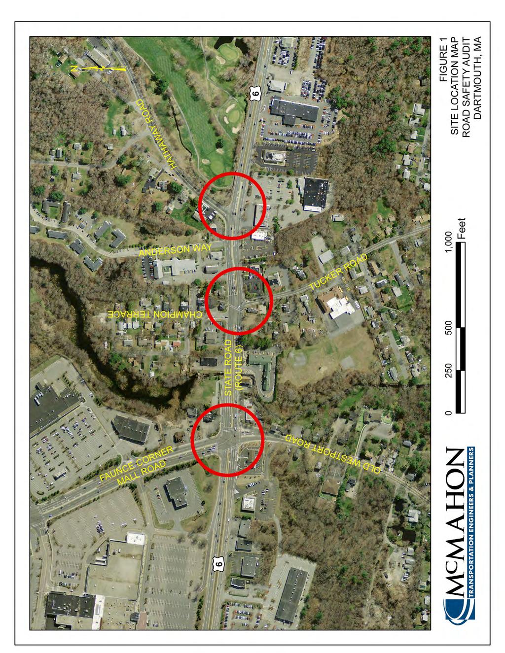
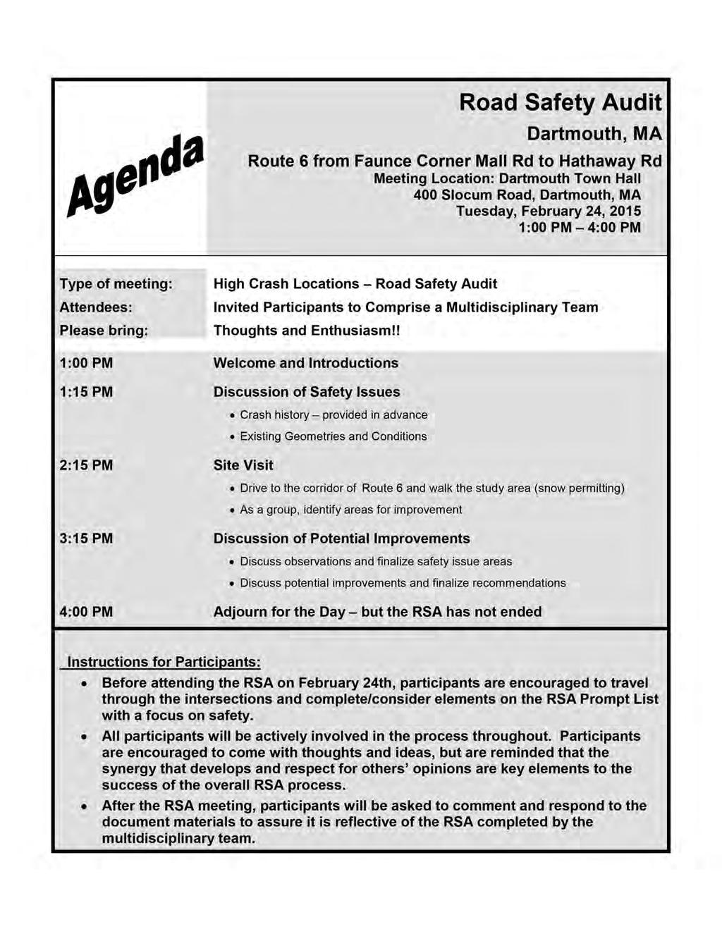
3 Background The Federal Highway Administration (FHWA) defines a Road Safety Audit (RSA) as the formal safety examination of an existing or future road or intersection by an independent, multidisciplinary team. The purpose of an RSA is to identify potential safety issues and possible opportunities for safety improvements considering all roadway users. This RSA evaluates the following intersections on State Road (Route 6) in Dartmouth, MA, as shown in Figure 1. State Road (Route 6) at Hathaway Road State Road (Route 6) at Tucker Road/Champion Terrace State Road (Route 6) at Faunce Corner Mall Road A safety audit was scheduled for these intersections as part of the required MassDOT design process for the three study area intersections included in a proposed design for this corridor. The proposed design project calls for the reconfiguration of Tucker Road to be relocated from its current connection to State Road (Route 6) and reconnected opposite Hathaway Road to the east on Route 6. This intersection of Tucker Road and Hathaway Road at Route 6 is proposed to be signalized and the previous location of Tucker Road (to be referred to as Old Tucker Road) will have the existing traffic signal removed. The intersections of State Road (Route 6) with Faunce Corner Mall Road and with Hathaway Road were both identified as Highway Safety Improvement Program (HSIP) intersections from A key objective of the RSA is to identify both short-term and long-term safety improvements that can be made at the subject intersections. Project Data A Road Safety Audit was completed for the study area intersections abutting State Road (Route 6) in the Town of Dartmouth on February 24, The agenda for the RSA meeting held at Dartmouth Town Hall is provided in Appendix A of this report. As shown below in Table 1, the audit team consisted of a multidisciplinary team with representatives from state, regional and local agencies providing expertise in the engineering, planning, maintenance and emergency response fields. Contact information for the RSA attendees is provided in Appendix B of this report. Page 1
4 Table 1. Participating Audit Team Members Audit Team Member Agency/Affiliation Lisa Schletzbaum MassDOT Traffic Safety John Mastera MassDOT Traffic Safety William Ullom MassDOT Traffic Safety Michael Fusco MassDOT Traffic Safety Filbert Yee MassDOT - Boston Projects Richard Oliveira MassDOT District 5 Projects Lisa Estrela - Pedro SRPEDD Guoqiang Li SRPEDD David Hickox Town of Dartmouth DPW John Hansen Town of Dartmouth Town Planner David Cressman Town of Dartmouth Town Administrator Joseph Vieira Town of Dartmouth Police Department Kayla Cabral Vanasse Hangen Brustlin (VHB) Rick Rhodes Vanasse Hangen Brustlin (VHB) Phil Viveiros McMahon Associates Allison Luff McMahon Associates Within the invitation sent on February 13, 2015 to each participant in the RSA, background material was provided. This information included collision diagrams and MassDOT crash data summaries for the study area intersections. During the RSA meeting, these materials were reviewed as a group before the team discussed potential solutions for the existing safety issues. Due to unsuitable field conditions brought by recent weather, the RSA team was unable to conduct a field visit; visual tools such as Google Earth were supplemented for the field visit. Throughout the meeting, the team observed and identified various safety issues throughout the Route 6 corridor. In conjunction with the use of supplemental visual tools, the team discussed additional concerns and potential solutions for the existing safety issues. Project Location and Description Study Area Roadways As shown in Figure 1 State Road (Route 6) is typically a four-lane roadway that runs in the east-west direction through the project study area and in the Town of Dartmouth with a posted speed limit of 40 miles per hour in either direction. State Road (Route 6) is classified as an urban principal arterial under MassDOT jurisdiction between Faunce Corner Mall Road and Hathaway Road. The travel lanes on State Road vary in width throughout the corridor, but are typically approximately 12 feet wide. There is a shoulder measuring approximately 9 feet in width along the southern side of Route 6 and a narrow shoulder varying in width present along the northern side. A sidewalk that is approximately 5 feet wide is generally present along either side of State Road (Route 6) through the study area. Hathaway Road is a two-lane urban minor arterial under town jurisdiction that runs in a northeast/southwest direction through Dartmouth connecting to New Bedford to the northeast. Hathaway Road has a single lane of travel in either direction measuring approximately 15 feet in width and Page 2
5 approximately 5-foot wide shoulders on either side of the roadway. There is no sidewalk present on Hathaway Road. Tucker Road is a two-lane urban minor arterial under town jurisdiction that runs in a north/south direction through Dartmouth, and acts as a major connection to residential areas in the southern portion of town. Tucker Road has a single lane of travel in either direction measuring approximately 11 feet in width and shoulders on either side of the roadway measuring approximately 1-2 feet wide. There is a sidewalk present on the western side of the roadway, and a small segment of sidewalk exists on the eastern side of Tucker Road between Route 6 and the adjacent Dunkin Donut s driveway. Faunce Corner Mall Road, adjacent to the intersection with State Road (Route 6), is a four-lane urban principal arterial under town jurisdiction that runs in a north/south direction through Dartmouth, with the southern limit of the roadway at Route 6. Faunce Corner Mall Road has two lanes of travel in either direction measuring 12 feet in width. There are varying shoulder widths along either side of the roadway due to the presence of multiple auxiliary lanes and sidewalk is present on either side of the roadway. Old Westport Road is a two-lane urban minor arterial under town jurisdiction that runs in a north/south direction through Dartmouth, and is a major connection to the University of Massachusetts-Dartmouth (UMass-Dartmouth) campus. Old Westport Road has a single lane of travel in either direction measuring approximately 13 feet in width and shoulders on either side of the roadway measuring approximately 1-2 feet wide. There is sidewalk present on the eastern side of the roadway and a small segment of sidewalk exists on the western side of Old Westport Road measuring approximately 300 feet from Route 6. Study Area Intersections The intersection of State Road (Route 6) at Hathaway Road/Shopping Plaza is a four-legged unsignalized intersection maintained by MassDOT. The eastbound and westbound approaches both consist of an exclusive left turn lane, an exclusive through lane, and a shared through and right turn lane. There is no traffic control for the approaches along Route 6. The northbound and southbound approaches both consist of a single multi-use lane. The southbound approach is controlled by a stop sign and stop line while the northbound approach is uncontrolled, but assumed to be stop controlled as it approaches Route 6. The intersection of State Road (Route 6) at Tucker Road/Champion Terrace is a four-legged signalized intersection maintained by MassDOT. The eastbound approach on State Road (Route 6) consists of an exclusive left turn lane, two through lanes, and an exclusive right turn lane. The westbound approach consists of an exclusive left turn lane, two through lanes, and a shared through and right turn lane. The northbound and southbound approaches on Tucker Road and Champion Terrace are offset by approximately 75 feet and both consist of a single multi-use lane. There are three phases for vehicular traffic, including a lead eastbound and westbound left turn phase, a phase for eastbound and westbound traffic, and a phase for northbound and southbound traffic with permitted left turns. There is also a pushbutton activated pedestrian phase with a crosswalk spanning Route 6 connecting to the southwestern and northeastern corners of the intersection. The intersection of State Road (Route 6) at Faunce Corner Mall Road is a four-legged signalized intersection maintained by MassDOT. The eastbound approach on State Road (Route 6) provides an exclusive left turn lane, two through lanes, and an exclusive right turn lane. The westbound approach consists of an exclusive left turn lane, three through lanes, and an exclusive right turn lane. West of the intersection, the rightmost through lane in the westbound direction provides access to a frontage road serving the Dartmouth Mall, while the remaining two through lanes continue on Route 6. In the southbound direction on Faunce Corner Mall Road, an exclusive left turn lane and an exclusive right turn Page 3
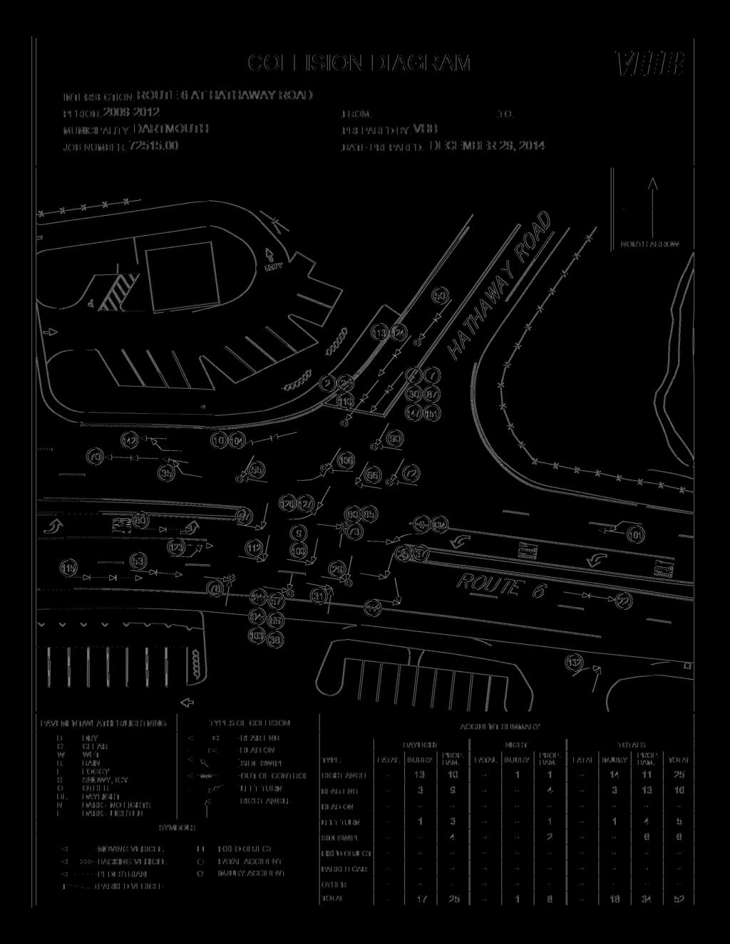
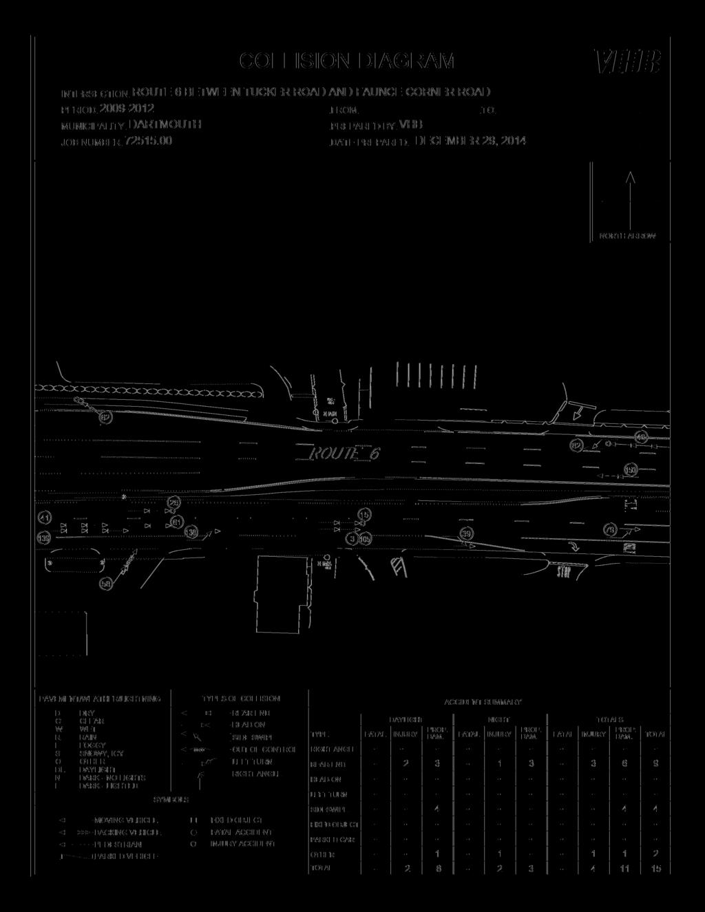
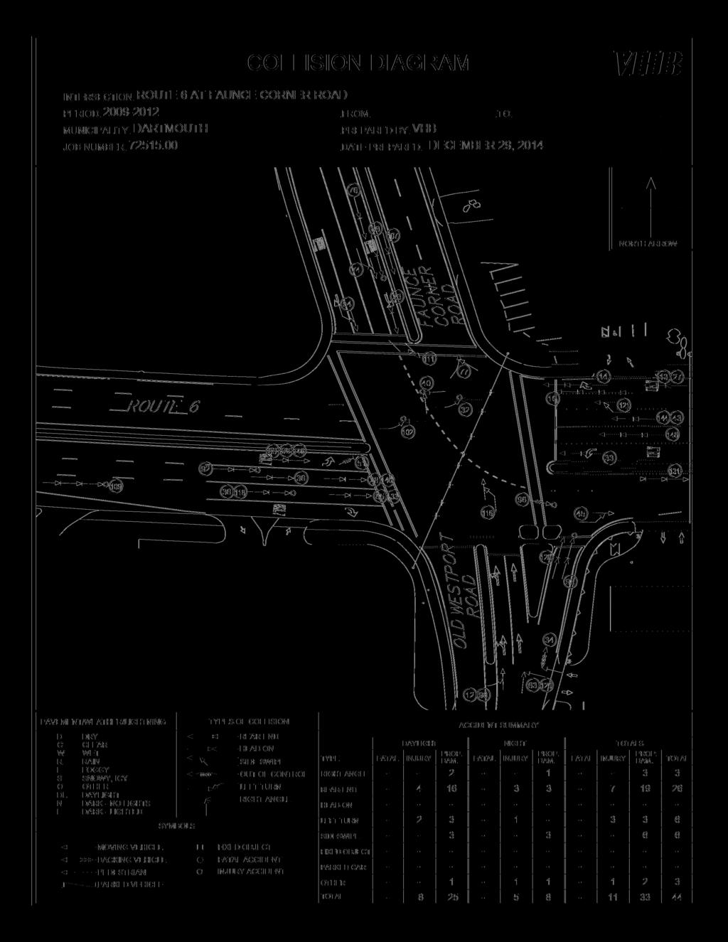
6 lane are marked with appropriate pavement makings and supplemental signage, with two unmarked lanes between them. Audit participants indicated that the left-most unmarked lane serves as a second left-turn lane, while the other lane is most commonly used as a through lane. There are also dotted lane extension lines through the intersection for the left turn. In the northbound direction on Old Westport Road, there is a shared left turn and through lane, an exclusive through turn lane, and a channelized right turn lane. The traffic signal operates with four phases for vehicular traffic including a lead eastbound and westbound left turn phase, an eastbound and westbound through phase, a southbound phase, and a northbound phase. Additionally, there is a push-button activated pedestrian phase that runs concurrently with the vehicular traffic phases. The area surrounding the audit intersections primarily consists of commercial land uses with several abutting driveways along either side of State Road (Route 6). As shown in Figure 2, there is a Dunkin Donuts on the southeast corner of Route 6 and Tucker Road, a Burger King and Pizza Shop to the south of Hathaway Road, and several other commercial properties adding to the issues within this corridor. Crash Data Crash data was received from the Town of Dartmouth Police Department for the years Based on this data, there were a total of 44 crashes reported from the beginning of 2009 through the end of 2012 at the intersection of State Road (Route 6) and Faunce Corner Mall Road. Of the crashes that occurred, approximately 60% were rear-end collisions, including 12 rear-end crashes in the eastbound direction and eight in the westbound direction on State Road (Route 6). There were also five sideswipe collisions in locations where lane designation may be unclear. The remaining crashes were angle and single vehicle collisions at this location. Of the 44 crashes, 11 involved personal injuries. Within the segment of State Road (Route 6) between Faunce Corner Mall Road and Tucker Road, there was a total of 15 crashes that occurred in the four-year period analyzed. Of the 15 crashes that occurred, nine crashes were rear-end collisions that occurred at abutting driveways on Route 6. The remaining collisions varied in type, but were mainly crashes that occurred at abutting driveways. At the intersection of State Road (Route 6) at Tucker Road, there were a total of 29 crashes reported. A total of 18 of these crashes were rear-end collisions, all of which occurred on State Road (Route 6). There were five crashes that were the result of the permitted left turns from the northbound and southbound approaches. Of the 29 crashes that occurred, six crashes involved personal injury. At the intersection of State Road (Route 6) at Hathaway Road, there were a total of 52 crashes reported. A total of 25 of these crashes were rear-end collisions. While 12 of these crashes occurred at the stop controlled approach on Hathaway Road, the remaining crashes occurred on free movements on State Road (Route 6). This is likely due to vehicles stopping short for crossing traffic to and from Hathaway Road and the adjacent shopping center driveway. Additionally, 25 crashes were angle collisions involving vehicles entering and exiting the adjacent shopping center as well as Hathaway Road. Detailed crash diagrams are provided in Appendix C. Page 4
7
8
9 Road Safety Audit Observations and Potential Improvements During the RSA meeting, a brief introduction of the RSA process and a summary of the study area and crash information were presented to the audit participants. Following this brief presentation, the members of the audit team were asked to discuss the existing issues that may affect safety at the intersections along the State Road (Route 6) corridor between Faunce Corner Mall Road and Hathaway Road. Provided below is a list of the safety concerns that were identified during the RSA for each intersection and for the corridor as a whole and the potential enhancements identified during the RSA. State Road (Route 6) at Hathaway Road Safety Issue #1: Traffic Control Observations: The northbound and southbound approaches from Hathaway Road and the shopping plaza driveway are stop controlled, while the eastbound and westbound movements are free flowing with a speed limit of 40 mph. For a vehicle to make a left out of either driveway, they must cross three lanes of traffic and merge into a high speed roadway. Additionally, there are a significant number of vehicles crossing Route 6 between Hathaway Road and the shopping center driveway that are required to cross six lanes of traffic, including the eastbound and westbound left turn lanes. The traffic controls at this intersection may be a factor in the number of angle collisions. It was also noted by audit participants that though Hathaway Road is striped as a single multi-use lane approach at the intersection with Route 6, vehicles typically form two lanes since the approach lane is wide enough to do so. Drivers have also been observed to drive over the double yellow center line to form two lanes, as noted by some audit participants. While drivers often use the leftmost lane that is queued as a left turn and through lane and the rightmost lane as an exclusive right turn lane, vehicles often turn right from both lanes, forming a double right turn onto Route 6 westbound. There is a large volume of right turning vehicles at this location, as Hathaway Road is often used to avoid the congested intersections along Faunce Corner Mall Road. This alternative use to the existing lane geometry may be a contributing factor to the number of rear-end collisions on Hathaway Road as well as the sideswipe collisions as vehicles enter Route 6 westbound. Enhancements: Signalize the intersection to provide right-of-way to vehicles entering and exiting the minor approaches and reduce the number of angle collisions at this location, as well as improve capacity on the minor approaches reducing driver frustration. Traffic signals, if implemented, should be mounted on the far side of the intersection, overhead, as the preferred method noted in the Manual on Uniform Traffic Control Devices (MUTCD). Restrict the northbound approach driveway to right-in/right-out to reduce angle collisions for vehicles attempting to cross Route 6. Signalize the intersection and allow protected only left turns to eliminate the angle collisions caused by permissive left turns. Page 7
.")
10 Evaluate opportunities to increase safety by providing one approach lane on Hathaway Road by cross hatch, bike lane, or another alternative. This will eliminate the two-lane stacking and improve sight distance to the left (east). Safety Issue #2: Sight Distance Observations: Audit participants noted visibility issues for the southbound approach on Hathaway Road at the intersection with State Road (Route 6). Sight distance to the east is obstructed by the adjacent tree and fence line adjacent to the Country Club of New Bedford golf course. In addition, it was noted by audit participants that since the roadway is wide enough for vehicles to form two stacking lanes, there are additional visibility issues for right turning vehicles in the rightmost stacking lane to see beyond the vehicle queued to their left. These conditions may be a Poor sight distance looking east on State Road contributing factor to the five crashes that at Hathaway Road occurred between the southbound movement exiting Hathaway Road and the westbound traffic on Route 6. Sight distance issues were also discussed for the eastbound and westbound left turn lanes on State Road (Route 6). The lane geometry allows for a negative offset between the lanes where the left turn lane aligns with the adjacent median and left turn lane for the opposing direction. This causes visibility problems as drivers are not able to see oncoming traffic beyond the opposing left turn queue. This may be a contributing factor in the number of angle collisions between left turns and opposing through movements along Route 6. It was also identified during the RSA that there is a slight horizontal curve approaching the intersection in the eastbound direction that adds to the sight distance problems at this intersection. Coupled with vegetation along the street, these constraints present sight distance problems for the drivers exiting shopping center driveway. Five angle collisions at this intersection involved vehicles exiting the shopping center driveway and an additional two rear-end collisions may also be a result of driveway operations as drivers are forced to stop short of the driveway. Enhancements: Determine property lines to the east of Hathaway Road and work with the adjacent property owners to trim vegetation to improve sight distance. Realign the eastbound and westbound left turn lanes to have a positive offset and reduce visibility problems. Investigate Town bylaws for vegetation required in a parking lot and see if the trees adjacent to the parking lot entrance on the southern side of Route 6 can be removed to improve sight distance to the west. Page 8

11 With the future improvements to signalize the intersection, introduce a No Right Turn on Red condition if there is insufficient sight distance. With future improvements to signalize the intersection, include protected-only left turn signal phases to reduce the number of angle collisions caused by the permissive left turns. Safety Issue #3: Drainage Observations: Audit participants discussed drainage at the intersection of State Road (Route 6) and Hathaway Road as a significant problem. There is a catch basin in the northeast corner of the intersection that collects runoff from Route 6. Audit participants representing the Town of Dartmouth described this catch basin as having significant drainage problems and flooding when it rains and that it is among the worst locations along Route 6 within the Town of Dartmouth. Enhancements: Review the existing drainage problem at this location. Determine if the problem is due to debris and provide appropriate maintenance. Determine if additional drainage or catch basins are required. This may be considered as part of future improvements to signalize the intersection. Based on comments received following the RSA meeting, MassDOT is in the process of determining if a maintenance project to improve drainage is feasible. Safety Issue #4: Roadway Conditions Observations: The eastbound left turn lane provides approximately 125 feet of storage space for the eastbound left turn queue. Audit participants noted the lane frequently does not provide enough capacity and the vehicle queue backs into the leftmost eastbound through lane, causing capacity problems for the eastbound approach and driver frustration. An audit participant noted that vehicles will often bypass the queue under these circumstances and make a U-turn on Route 6 to the east of the intersection at the next available median break, then access Hathaway Road Left turning vehicles on Route 6 attempting to cross oncoming through traffic via the westbound right turn. This movement causes additional capacity problems for the vehicles exiting Hathaway Road. It was also noted by audit participants that the warning signage for the unsignalized intersection (W2-2) is present; however, a supplemental plaque labeling the cross street at Hathaway Road is not present. Additionally, the street sign for Hathaway Road is set back from the intersection and difficult to see. This may cause additional conflicts if an unfamiliar driver is traveling through the area. Page 9
 that access to State Road via Slocum Road is a safer and preferred alternative to accessing")
12 Enhancements: Lengthen the eastbound left turn lane to provide additional storage space. Provide education to patients of Hawthorn Medical Associates (located just east of the intersection) that access to State Road via Slocum Road is a safer and preferred alternative to accessing Hawthorn Medical Associates directly from Hathaway Road. Signalize the intersection to allow a protected left turn phase and improve capacity. Add the appropriate supplemental plaques to the existing intersection warning signage. Provide larger street signs for Hathaway Road to better inform motorists on Route 6. Safety Issue #5: Pedestrian and Bicycle Amenities Observations: At the intersection of State Road (Route 6) at Hathaway Road, there are no pedestrian connections crossing Route 6 or crossing either of the minor approaches. There is sidewalk along the southern side of the roadway and a shoulder that is approximately 8 feet in width, but no other amenities for pedestrians or bicycles are present at this location. Enhancements: Provide crosswalks spanning Hathaway Road and the shopping center driveway. Provide a sidewalk along the northern side of the roadway. Provide a dedicated bicycle lane on the southern side of Route 6 and the western side of Hathaway Road. Signalize the intersection to provide pedestrians crossings across State Road (Route 6). State Road (Route 6) at Tucker Road Safety Issue #1: Roadway Geometry Observations: During the RSA, it was discussed that there are several geometric issues at the intersection of State Road (Route 6) at Tucker Road. The first is the radius of the eastbound right turn onto Tucker Road. It was noted by participants that the radius of this right turn is very small and it is difficult for larger vehicles to make, and they often have to cross into the northbound lane of Tucker Road to complete the turn. While no crashes have been attributed to this maneuver, it is still a concern to the audit team. Perhaps the largest geometric problem with this intersection is the offset between the northbound approach of Tucker Road and the southbound approach of Champion Terrace of approximately 75 feet. The traffic signal phasing currently has these two approaches running concurrently with permissive left turns. Audit participants noted that left turning vehicles for either approach are not able to keep to the right of the oncoming left Off-set intersection geometry between Tucker Road and Champion Terrace Page 10
13 turn and they move to the left instead as the geometry allows. There are four crashes over the four year period reviewed that are a conflict between northbound and southbound vehicles. The northbound and southbound approach offset also creates an issue on State Road (Route 6) as well. To clear through the intersection, a vehicle on Route 6 must travel nearly 200 feet. Many vehicles that frequently travel this corridor know that they will not clear the intersection in the yellow time allotted if they proceed through a yellow light and stop. Other drivers, however, who intend to continue through the yellow light are in conflict with these drivers and cause rear-end collisions. There are a total of 18 rear-end crashes on Route 6 at this intersection, accounting for over 60% of the total crashes. The traffic signals are also placed mid-intersection which may mislead drivers to think it is a smaller sized intersection. There is also a slight curve at this intersection that causes the westbound approach to angle inward towards the eastbound approach. While it was not reflected in the crash data, this alignment can cause driver confusion if the roadway is not aligned the way they would typically expect and can be a contributing factor in head-on collisions. Enhancements: Move the northbound approach stop line back to allow for larger vehicles to clear the eastbound right turn to Tucker Road. Increase the right turn radius to accommodate larger vehicles in accordance to latest design standards. Review clearance timings to determine if there is adequate yellow and all red time and adjust as needed. Add dotted lane extension lines to help delineate the northbound and southbound left turns. If Tucker Road is relocated due to the proposed project and the intersection is unsignalized, make Tucker Road a one-way road southbound from Route 6 to eliminate the need for traffic control at this location. Relocate traffic signals to the far side of the intersection for the eastbound and westbound approaches to help drivers determine the length of the intersection. Realign roadway to eliminate westbound angle towards the eastbound approach. If Tucker Road is relocated due to the proposed project and the intersection is unsignalized, extend the median through the intersection to make Tucker Road and Champion Terrace right-in/right-out only. Safety Issue #2: Traffic Control Observations: The audit team noticed several issues at the intersection with regards to traffic control. The first issue is that the offset northbound and southbound approaches run together. As previously noted, there are conflicts between the northbound and southbound movements, particularly with the left turns. It was also noted during the meeting that the traffic signal often rests on green on the minor streets during off-peak times when the green light should be Page 11
14 resting on State Road (Route 6) and that the green indications for both the minor streets and the eastbound and westbound left turns have a green light when there is no call. An additional issue at this intersection is the use of the breakdown/parking lane on Route 6 eastbound to the west of the intersection with Tucker Road. Currently there is an eastbound right turn lane that extends approximately 150 feet. To the east, there is a wide shoulder extending back to Faunce Corner Mall Road that vehicles use as a travel lane to enter the right turn lane. An audit member representing the Dartmouth Police Department noted that it is difficult to cite people for traveling in the breakdown lane at this location because the area in front of the Car Wash to the west of Tucker Road is technically designated as on-street parking. While it is not typically used as on-street parking, allowing parking on the state highway could contribute to congestion as well as sideswipe collisions in this area. This condition could be a contributing factor in the two rear-end collisions that specifically occurred in the eastbound right turn lane. This condition also can cause sideswipe collisions as drivers try to navigate into a lane that other vehicles are traveling in. Drivers also have been using the eastbound right turn lane as a shared through and right turn lane, as the shoulder to the east of Tucker Road before the Dunkin Donuts driveway is wide enough to act as a receiving lane. Vehicles have been observed to travel through the intersection in this lane, and then merge back into Route 6 eastbound traffic at the Dunkin Donuts to bypass the eastbound through queue on State Road (Route 6). To make this maneuver, drivers will often signal as if they are entering the Dunkin Donuts Driveway on Route 6, then change at the driveway to merge back onto Route 6. This maneuver can cause additional sideswipes, though none were reported over the period analyzed. During the RSA meeting, comments were made regarding traffic signal equipment. Currently there is one traffic signal mounted overhead in either direction on State Road (Route 6), as well as one post mounted signal for each Route 6 approach. The placement of traffic signals mid-intersection, instead of far side, may give drivers a false impression of a smaller sized intersection. The post mounted traffic signal head is difficult to see due to the queued vehicles blocking the signal indications. Additionally, there is a No Right Turn on Red sign for the southbound approach from Champion Terrace. The sign, however, is across Route 6 on the southern side of the roadway. This location is often obstructed by vehicles and not in a location that is easily readable by drivers. Audit participants also observed that the signal may not be timed properly to work in coordination with the adjacent signal at Faunce Corner Mall Road, creating additional congestion on Route 6. Problems were also noted just south on Tucker Road at the intersection with the Dunkin Donuts driveway. As vehicles queue back on Tucker Road from the intersection with Route 6, the queue blocks the driveway despite the presence of signage instructing drivers to not block the driveway. Vehicles frequently access this driveway from Route 6. When the driveway is blocked, vehicles queue back onto Route 6, causing additional congestion on Route 6 eastbound. Additionally, it was observed that conflicts occur when vehicles exit the Dunkin Donuts driveway on Route 6 and turn left through the scored concrete median break adjacent to the fire station across the street. While there is signage facing both direction of Route 6 prohibiting left turns through this median (except for authorized vehicles), no such signage appears to be in place informing drivers exiting Dunkin Donuts of this restriction. A related Page 12
15 observation made by some audit participants noted the lack of right turn only or one-way signage to guide drivers exiting various commercial driveways in the vicinity of the intersection. Enhancements: Investigate split phasing between the northbound and southbound approaches to eliminate left turn conflicts. Investigate detection issues causing the signal to rest on green on Tucker Road and give green to other approaches with no vehicular demand. Make the southbound approach on Champion Terrace fully actuated to reduce the number of calls to this approach, if split phasing is implemented. Restrict on-street parking on Route 6, as it is a state highway to enforce laws against breakdown lane travel. This measure should be coordinated between the Town and the MassDOT District 5 office to supply no parking signs along Route 6. Review traffic signal timings and coordination to reduce congestion and associated problems. Sign and stripe the breakdown lane to reiterate that travel in this lane is restricted. Update traffic signal equipment to allow for two overhead traffic signal heads on Route 6 in either direction for increased visibility of the signal heads. Relocate the No Right Turn on Red sign to the northern side of Route 6 to increase visibility of this sign. Stripe the intersection of Tucker Road at the Dunkin Donuts Driveway and add supplemental Do Not Block the Box signage. Add additional signage for No Left Turn at the Dunkin Donuts driveway on Route 6 through the emergency vehicle median access adjacent to the fire station. Evaluate the need for additional right turn only or one-way signage for commercial driveways in the vicinity of Tucker Road. Increase enforcement to deter vehicles exiting the Dunkin Donuts driveway to Route 6 via a left turn through the emergency vehicle median access adjacent to the fire station. Safety Issue #3: Pedestrian Accommodations Observations: At the intersection of State Road (Route 6) and Tucker Road, there is a crosswalk that spans the intersection connecting the southwest corner to the northeast corner. There are, however, no crosswalks available spanning the minor streets, or handicap ramps available at the existing crosswalk to accommodate all users. Under proposed conditions, this intersection will no longer be signalized and the crosswalk spanning Route 6 will be eliminated. Enhancements: Install handicap ramps on either side of the existing crosswalk. Install ADA-compliant crosswalks spanning the minor intersection approaches. Page 13
16 State Road (Route 6) at Faunce Corner Mall Road Safety Issue #1: Traffic Control Observations: The largest issue discussed at the intersection of State Road (Route 6) at Faunce Corner Mall Road was the southbound approach on Faunce Corner Mall Road. Several issues were identified with this approach. The first issue is that while the left and right turn lanes are clearly marked with appropriate signage and striping, the two center lanes are not. The leftmost center lane is typically used as a left turn and through lane. Problems arise, however, when the rightmost lane also is used as a left turn and through lane. There are only two receiving lanes on Route 6 eastbound, so this third left turn lane utilizes the breakdown lane as a receiving lane. This may be a contributing factor in the number of rear-end and sideswipe collisions to the east of the intersection of Route 6 eastbound as vehicles in the breakdown lane attempt to merge back into the appropriate lanes. Additionally, there are conflicts with vehicles that continue through to Old Westport Road from the leftmost shared lane and vehicles that may be turning left from the right most through lane. It was also noted during the audit meeting that the left turning vehicles entering the intersection from Faunce Corner Mall Road are often met with downstream congestion at Tucker Road and frequently queue into the intersection. The northbound and southbound movements operate on split phasing with the southbound movement from Faunce Corner Mall Road going first. When this approach queues back into the intersection, the northbound approach from Old Westport Road is unable to enter the blocked intersection. While no crashes have been attributed to this congestion problem, the inability for the northbound movement aids in driver frustration, and drivers may attempt to move out of their path of travel to bypass the queued traffic blocking the intersection. Enhancements: Allow the northbound approach to precede the southbound approach in the split traffic signal phasing to eliminate the conflict between the northbound approach and the eastbound departure lane queues blocking the intersection. Increase enforcement to control intersection blocking. Evaluate coordination between the Tucker Road and Faunce Corner Mall Road intersections to reduce the queue spillback into the Faunce Corner Mall Road intersection. Include overhead diagrammatic lane signage to clearly identify the southbound lane usage in advance of the intersection. Consider providing additional information within lane usage signage to help inform drivers of the destination for each lane. Include pavement markings to clearly mark the lanes and enforce lane usage on Faunce Corner Mall Road. Page 14

17 Safety Issue #2: Traffic Operations Observations: It was discussed during the audit meeting that the eastbound left turn lane, which currently provides approximately 225 feet of queue storage, is frequently over capacity, causing the queue to spill back onto Route 6 eastbound and creating additional traffic problems for through vehicles. To bypass the left turn queue, vehicles often cut through the adjacent shopping center located at 331 State Road (Route 6) to the west and navigate through the parking lot connections to the Friendly s restaurant driveway on Old Westport Road, where drivers are able to access Faunce Corner Mall Road via the northbound through lanes. Another alternative to bypass the eastbound left turn queue is for vehicles to make the eastbound right turn onto Old Westport Road and make a U- Turn at the break in the median adjacent to the Mobil Station. There are four crashes in total for the period reviewed reported for these two situations to bypass the left turn queue. In addition, the westbound right turn lane from Route 6 westbound to Faunce Corner Mall Road was also observed to have major operational issues. There is a large volume of vehicles utilizing this right turn and the queue often extends back to Tucker Road. Audit participants noted that the lanes on Route 6 eastbound appear to be constrained in the vicinity of the Paskamansett River culvert, which may contribute to additional Vehicle attempts to cut into the westbound right turn queue to Faunce Corner Mall Road. congestion and queuing. As a result, vehicles try to merge into the queue, bypassing several vehicles, resulting in rearend collisions in the right turn lane as well as sideswipe collisions as vehicles attempt to cut the queue. There is also some confusion in the westbound direction with the rightmost through lane that exits to the Dartmouth Mall, which effectively creates a lane drop for westbound through movements and may be a sideswipe hazard. There are also vehicles that turn right from the rightmost through lane as there are two receiving lanes on Faunce Corner Mall Road, which can cause additional conflicts. In the eastbound direction, there are issues of vehicles traveling through from the right turn lane and continuing east in the right shoulder, similar to the issue encountered at the Route 6 eastbound approach to Tucker Road. As previously mentioned, this causes conflicts with vehicles in the right travel lane and is a contributing factor to sideswipe collisions on Route 6 eastbound. Enhancements: Extend the eastbound left turn lane to allow for additional storage space. Allow for additional time for the eastbound left turn movement to improve capacity. Provide two eastbound left turn lanes to improve capacity. Page 15
18 Extend the median on Old Westport Road to discourage drivers from making this U- Turn. Restrict operations of the Mobil station driveway on Old Westport Road to right-in/rightout only. Extend the westbound right turn lane to allow for additional capacity, which would include roadway widening at the Paskamansett River culvert. Provide two right turn lanes at the Route 6 westbound approach, or allow right turns from the rightmost westbound though lane. Delineate the right turn lanes on Route 6 with flexible delineators and/or channelize the right turn lane to keep vehicles from jumping the queue and causing sideswipe crashes. Enhance non-vehicular transportation options, such as providing shuttles servicing the shopping centers in the area and evaluating bicycle accommodations, to encourage other modes of transportation and alleviate congestion. Ensure that the cut through volume is included in the traffic volumes used for any future intersection analysis. Widen Route 6 to allow for increased capacity. Safety Issue #3: Roadway Conditions Observations: The intersection is heavily utilized and as such, there is significant rutting at each intersection approach as well as faded pavement markings. The pavement conditions can be a contributing factor for the high number of rear-end collisions that occurred at this intersection. Enhancements: Repave intersection to improve roadway surface. Restripe the intersection with thermoplastic striping to allow for durability of pavement markings. Safety Issue #4: Pedestrian Accommodations Observations: The pedestrian accommodations at the existing intersection allow for concurrent pedestrian phases for crossing Route 6 and the minor approaches. It was noted during the audit meeting that there is not sufficient crossing time for most users. Additionally, there are exclusive right turn lanes for each approach that are in conflict with the concurrent pedestrian phases. Pedestrians also often cross Route 6 to the west of the intersection to avoid crossing at Faunce Corner Mall Road. While no crashes involving pedestrians occurred over the period reviewed, pedestrian crossings could be a contributing factor to the number of rear-end collisions for right turning vehicles. Enhancements: Restrict right turn lanes to No Turn on Red to eliminate conflicts with pedestrians. Page 16
19 Review pedestrian clearance timings to ensure they are compliant with current MUTCD and MassDOT standards. Recommendations After the discussing the various safety deficiencies within the study area, participants discussed potential solutions. The audit participants were encouraged to consider both short and long-term improvements for each of the existing safety issues. Each improvement considered has been categorized as short-term, midterm, or long-term based on the definitions shown in Table 2. Additionally, a cost category has been assigned to each improvement based on the parameters set forth in Table 2. Table 2. Estimated Time Frame and Costs Breakdown Time Frame Costs Short-Term <1 Year Low <$10,000 Mid-Term 1-3 Years Medium $10,001-$50,000 Long-Term >3 Years High >$50,000 Summary of Road Safety Audit A summary of the potential recommendations discussed by the RSA audit team are summarized in Table 3. The recommendations are summarized based on the potential safety payoff, time frame, approximate cost and responsible agency. The safety payoff is a subjective judgment of the potential effectiveness of the safety recommendations listed below. Improvements marked with an asterisk (*) are improvements to the proposed design. Page 17
20 Table 3. Potential Safety Enhancement Summary Safety Issue Potential Safety Enhancement Safety Payoff Time Frame Cost Responsible Agency State Road (Route 6) at Hathaway Road Traffic Control Signalize intersection High Long-Term High MassDOT Traffic Control Traffic Control *Mount traffic signals on the far side of the intersection approaches. Restrict the northbound approach driveway to right-in/right-out High Long-Term High MassDOT Medium Short-Term Low Town of Dartmouth Traffic Control *Allow protected only left turns High Long-Term High MassDOT Traffic Control Sight Distance Sight Distance Sight Distance Evaluate opportunities to provide a one lane southbound approach Determine property lines east of Hathaway Road and trim adjacent vegetation to improve sight distance Realign eastbound and westbound left turn lanes to have a positive offset Determine if vegetation on southern side of the road can be removed, per town bylaws Low Short-Term Low Medium Short-Term Low Town of Dartmouth Town of Dartmouth/ MassDOT/ Property Owners Low Long-Term High MassDOT Low Short-Term Low Town of Dartmouth Sight Distance *Introduce a No Right Turn on Red condition Medium Long-Term Low MassDOT Sight Distance *Include protected left turn signal phasing High Long-Term Medium MassDOT Drainage Review existing drainage Low Short-Term Low MassDOT Drainage Provide appropriate debris maintenance Low Short-Term Low MassDOT Drainage Drainage Determine if additional drainage or catch basins are required Determine if a maintenance project to improve drainage is feasible Medium Long-Term High MassDOT Medium Long-Term High MassDOT Roadway Conditions Lengthen the eastbound left turn lane Medium Mid-Term Medium MassDOT Roadway Conditions Educate Hawthorn Medical patients to use Slocum Road Low Short-Term Low Town of Dartmouth/ Hawthorn Medical Page 18
21 Safety Issue Potential Safety Enhancement Roadway Conditions Roadway Conditions Roadway Conditions Pedestrian & Bicycle Amenities Pedestrian & Bicycle Amenities Pedestrian & Bicycle Amenities Pedestrian & Bicycle Amenities Roadway Geometry Roadway Geometry *Signalize the intersection to allow protected left turn phases Add appropriate supplemental plaques to intersection warning signage identifying Hathaway Road Provide larger street signs for Hathaway Road to better inform motorists on Route 6 Provide crosswalks spanning Hathaway Road and the shopping center driveway Provide a sidewalk along the northern side of the roadway Provide a dedicated bicycle lane on the southern side of Route 6 and western side of Hathaway Road *Signalize the intersection to provide crossings across Route 6 Safety Payoff State Road (Route 6) at Tucker Road Move Tucker Road northbound approach stop line back Increase eastbound right turn radius to accommodate larger vehicles Time Frame Cost Responsible Agency High Long-Term High MassDOT Low Short-Term Low MassDOT Low Short-Term Low Medium Short-Term Low Town of Dartmouth Town of Dartmouth Medium Mid-Term Medium MassDOT Low Short-Term Low MassDOT/Town of Dartmouth Medium Long-Term High MassDOT Low Short-Term Low Medium Long-Term High Town of Dartmouth Town of Dartmouth/ MassDOT Roadway Geometry Review traffic signal clearance timings Medium Short-Term Low MassDOT Roadway Geometry Add dotted lane extension lines for the northbound and southbound left turns Medium Mid-Term Low MassDOT Roadway Geometry *Make Tucker Road one-way in from Route 6 Low Long-Term Low Roadway Geometry Roadway Geometry Roadway Geometry Relocate traffic signals to the far side of the intersection Realign roadway to eliminate the westbound angle towards the eastbound approach. *Extend the median on Route 6 to make minor streets right-in/right-out Town of Dartmouth Low Long-Term Medium MassDOT Low Short-Term High MassDOT Medium Long-Term High MassDOT Page 19
22 Safety Issue Potential Safety Enhancement Traffic Control Provide split phasing between the northbound and southbound approaches Safety Payoff Time Frame Cost Responsible Agency Medium Mid-Term Medium MassDOT Traffic Control Investigate detection issues Low Short-Term Low MassDOT Traffic Control Make the southbound approach fully actuated if split phasing is implemented Low Short-Term Low MassDOT Traffic Control Restrict on-street parking on Route 6 Low Short-Term Low MassDOT/Town of Dartmouth Traffic Control Review traffic signal timings and coordination Medium Short-Term Low MassDOT Traffic Control Sign and stripe breakdown lane to restrict travel Low Mid-Term Low MassDOT Traffic Control Update traffic signal equipment Low Mid-Term High MassDOT Traffic Control Traffic Control Traffic Control Traffic Control Traffic Control Pedestrian Accommodations Pedestrian Accommodations Traffic Control Traffic Control Relocate the No Right Turn on Red to the northern side of the intersection Add Do Not Block Box signage and markings for the Dunkin Donuts driveway on Tucker Road Add additional No Left Turn signage for left turns exiting Dunkin Donuts via the emergency access median break on Route 6 Evaluate the need for additional right turn only or one-way signage for commercial driveways in the vicinity of Tucker Road. Increase enforcement for left turns exiting Dunkin Donuts via the emergency access median break on Route 6 Install handicap ramps on either side of the existing crosswalk Install ADA compliant crosswalks spanning the minor intersection approaches State Road (Route 6) at Faunce Corner Mall Road Allow the northbound approach to precede the southbound approach in traffic signal phasing Increase enforcement to control intersection blocking. Low Short-Term Low MassDOT Low Short-Term Low Town of Dartmouth Low Short-Term Low MassDOT Low Short-Term Low Low Short-Term Low MassDOT/ Property Owners Town of Dartmouth Low Short-Term Medium MassDOT Low Short-Term Low Town of Dartmouth High Mid-Term Low MassDOT Low Short-Term Low Town of Dartmouth Page 20
23 Safety Issue Potential Safety Enhancement Safety Payoff Time Frame Cost Responsible Agency Traffic Control Evaluate signal coordination with Tucker Road Medium Short-Term Low MassDOT Traffic Control Traffic Control Include overhead diagrammatic lane usage signage Consider additional destination information within lane usage signage Medium Mid-Term Medium Low Mid-Term Medium Traffic Control Include lane usage pavement markings Low Short-Term Low MassDOT/Town of Dartmouth MassDOT/Town of Dartmouth MassDOT/Town of Dartmouth Traffic Operations Extend eastbound left turn lane Medium Mid-Term Medium MassDOT Traffic Operations Allow additional time for the eastbound left turn movement Medium Short-Term Low MassDOT Traffic Operations Provide two eastbound left turn lanes High Long-Term High MassDOT Traffic Operations Traffic Operations Traffic Operations Traffic Operations Traffic Operations Extend the median on Old Westport Road to discourage U-Turns Restrict operations of the Mobil station driveway on Old Westport Road to right-in/right-out only. Extend the westbound right turn lane, which may require roadway widening at the Paskamansett River culvert Provide two right turn lanes at the Route 6 westbound approach Delineate right turn lane with channelizing flexible delineators Low Mid-Term Medium Low Short-Term Low Town of Dartmouth Town of Dartmouth/Mobil Medium Long-Term High MassDOT High Long-Term High MassDOT Low Short-Term Low MassDOT Traffic Operations Enhance non-vehicular transportation options Low Mid-Term Low Traffic Operations Ensure that the cut through volume is included in the traffic volumes used for any future intersection analysis. Low Short-Term Low MassDOT/Town of Dartmouth/ Property Owners MassDOT/Town of Dartmouth Traffic Operations Widen Route 6 to allow for increased capacity. High Long-Term High MassDOT Roadway Conditions Repave intersection to improve roadway surface Low Mid-Term Medium MassDOT Roadway Conditions Restripe intersection with thermoplastic Low Short-Term Low MassDOT Page 21
24 Safety Issue Potential Safety Enhancement Pedestrian Accommodations Pedestrian Accommodations Safety Payoff Time Frame Cost Responsible Agency Restrict right turn lanes to No Turn on Red Medium Mid-Term Low MassDOT Review pedestrian clearance timings Low Short-Term Low MassDOT Page 22
25 Appendix A. RSA Meeting Agenda
26
27 Appendix B. RSA Audit Team Contact List
28 Participating Audit Team Members Date: February 25, Location: Dartmouth Town Hall, Dartmouth, MA 2015 Audit Team Phone Agency/ Affiliation Address Members Number Lisa Schletzbaum MassDOT Traffic Safety John Mastera MassDOT Traffic Safety William Ullom MassDOT Traffic Safety Michael Fusco MassDOT Traffic Safety Filbert Yee MassDOT - Boston Filbert.Yee@state.ma.us Projects Richard Oliveira MassDOT District 5 Richard.Oliveira@dot.state.ma.us Lisa Estrela - Pedro SRPEDD lestrela@srpedd.org Guoqiang Li SRPEDD gli@srpedd.org David Hickox Town of Dartmouth dhickox@town.dartmouth.ma.us DPW x210 John Hansen Town of Dartmouth jhansen@town.dartmouth.ma.us Town Planner David Cressman Town of Dartmouth cressmandg@town.dartmouth.ma.us Administrator Joseph Vieira Town of Dartmouth jvieira@dartmouthpd.org Police Department Kayla Cabral Vanasse Hangen kcabral@vhb.com Brustlin (VHB) Rick Rhodes Vanasse Hangen rrhodes@vhb.com Brustlin (VHB) Phil Viveiros McMahon Associates pviveiros@mcmahonassociates.com Allison Luff McMahon Associates aluff@mcmahonassociates.com
29 Appendix C. Detailed Crash Data
30

31
32
33
34 Crash Diagram Ref # Crash Data Summary Table Route 6 from Faunce Corner Road to Hathaway Road, Dartmouth, MA 1/1/ /31/2012 Crash Date Crash Day Time of Day Manner of Collision Light Condition Weather Condition Road Surface Driver Contributing Code m/d/y Type Type Type Type Type 1 1/10/2009 Saturday 10:30 AM Rear end Daylight Clear Dry Following too closely 2 2/14/2009 Saturday 5:30 PM Rear end Daylight Clear Dry Inattention 3 2/22/2009 Sunday 3:06 PM Rear end Daylight Cloudy Wet Following too closely 4 2/27/2009 Friday 7:27 AM Sideswipe, opposite direction Daylight Clear Dry Unknown 5 3/10/2009 Tuesday 3:41 PM Rear end Daylight Clear Dry Unknown 6 3/13/2009 Friday 11:31 AM Angle Daylight Clear Dry Failed to yield right of way 7 3/16/2009 Monday 4:36 PM Rear end Daylight Clear Dry Following too closely 8 3/23/2009 Monday 4:05 PM Head on Daylight Clear Dry Failure to keep in proper lane 9 4/10/2009 Friday 11:10 AM Angle Daylight Clear Dry Inattention 10 4/19/2009 Sunday 4:55 PM Rear end Daylight Clear Dry Inattention 11 5/8/2009 Friday 1:27 PM Angle Daylight Clear Dry Failed to yield right of way 12 5/16/2009 Saturday 2:06 PM Angle Daylight Clear Dry Inattention 13 5/30/2009 Saturday 3:17 PM Rear end Daylight Clear Dry Inattention 14 6/23/2009 Tuesday 4:27 PM Rear end Daylight Cloudy Dry Following too closely 15 7/3/2009 Friday 10:05 PM Rear end Dark lighted roadway Clear Dry Inattention 16 7/12/2009 Sunday 10:25 AM Rear end Daylight Cloudy Dry Inattention 17 7/16/2009 Thursday 4:00 PM Angle Daylight Clear Dry Failed to yield right of way 18 7/29/2009 Wednesday 10:00 AM Angle Daylight Cloudy Dry Inattention 19 7/30/2009 Thursday 4:26 PM Rear end Daylight Clear Dry Following too closely 20 8/10/2009 Monday 10:19 AM Rear end Daylight Clear Dry Following too closely 21 8/12/2009 Wednesday 8:55 AM Rear end Daylight Cloudy Dry Following too closely 22 8/30/2009 Sunday 8:51 PM Rear end Dark lighted roadway Clear Dry Following too closely 23 9/11/2009 Friday 1:59 PM Rear end Daylight Rain Wet Following too closely 24 9/14/2009 Monday 6:24 PM Angle Daylight Cloudy Dry Failed to yield right of way 25 9/18/2009 Friday 12:52 PM Angle Daylight Clear Dry Inattention 26 10/6/2009 Tuesday 3:41 PM Rear end Daylight Clear Dry Inattention 27 10/17/2009 Saturday 11:42 AM Rear end Daylight Cloudy Dry Following too closely Comments At the intersection of Hathaway and State Road eastbound, vehicle 2, moving slowly or stopped in traffic, was hit by vehicle 1 who was moving straight ahead Traveling southbound at the Hathaway and State Road intersection, there was a collision between vehicle 1 and vehicle 2. It is unclear who caused the accident Vehicle 1 and 2, both traveling eastbound on state road. Vehicle 2 is slowing down o stopped in traffic and is struck from behind by vehicle 1 On State Road, vehicle 1, traveling southbound, and vehicle 2, traveling eastbound, collide Vehicle 1 is taking a left and vehicle 2 is traveling straight ahead Vehicles 1,2 and 3 are traveling eastbound on State Road near Dartmouth Convenience. Vehicles 1 and 2 are slowing down and vehicle 3 crashes into vehicle 2, causing a chain reaction. Vehicle 1 is traveling southbound on State Road and vehicle 2 is traveling eastbound. Vehicle 1 is turning left and vehicle 2 is traveling straight ahead Traveling at the Hathaway and State Road intersection, vehicles 1 and 2 collide. It is unclea who causes the accident. At the intersection of State Road and Tucker Road, vehicle 1 is traveling westbound and vehicle 2 is traveling eastbound. Vehicle 2 is stopped in traffic and vehicle 1 is changing lanes. Vehicle 1 is traveling southbound on Hathaway Road and vehicle 2 is traveling eastbound Vehicle 1 enters the traffic lane and vehicle 2 is driving straight ahead At the intersection of Hathaway and State Road westbound, vehicle 2 is slowing down while vehicle 1 is entering the traffic lane Vehicle 1 is traveling northbound on State road and vehicle 2 is traveling eastbound. Vehicle 1 is entering traffic lanes and vehicle 2 is traveling straight ahead Vehicle 2 was turning into Mobil Gas station going south on Old Westport Road and struck Vehicle 1's side door with the front of his car Both vehicles are traveling west on State Rd./Route 6 near Faunce Corner Rd. Vehicle 1 struck vehicle 2 in the rear end as the operator of vehicle 1 was distracted by a cut on their arm. Also admitted to driving too closely Vehicle 3 was stopped at intersection at intersection of Faunce Corner Rd. and State Rd Vehicle 1 is closely following vehicle 2 and rear ends vehicle 2, which causes vehicle 2 to rearend vehicle 3. Vehicle 1 struck vehicle 2 from behind as the operator of vehicle 1 believed traffic was starting to move. Vehicle 4,3,2 stopped at the red light, in that respective order. Vehicle 1 did not stop quic enough and caused a chain reaction accident Vehicle 1, traveling in the right lane east bound on State Rd., and vehicle 2,making a left han turn onto State Rd. eastbound, collided at angle as one car crossed into the other's lane. It is unclear who crossed the lane. Vehicle 1, traveling north on Tucker Road, and Vehicle 2, traveling South on Tucker Road, were both taking left turns on a green light and collided. Vehicle 1 caused the accident. Vehicle 1 struck vehicle 2 from behind in the left travel lane on Rt. 6 west. Both cars were stopping for a traffic light and vehicle 1 was following too closely Vehicle 1 struck vehicle 2 from behind at the State Road and Champion Terrace intersection as both vehicles were traveling west. Vehicle 2 was rear ended as it was stopping in traffic at signal light for Route 6/Faunce Corner Rd Vehicle 1 and 2 are both traveling at the intersection of State Road and Hathaway Road and are slowing down. It is unclear who causes the crash Vehicle 2 changed lanes in front of Vehicle 1 then suddenly stopped causing Vehicle 1 to rea end Vehicle 2. Vehicle 2 was struck by vehicle 1, in the rear, on Faunce Corner Road at the light at the intersection of State Road. Vehicle 2 moved slowly at the green light due to traffic. Then, vehicle 1 struck vehicle 2. Vehicle 2, driving east on State Rd., gets hit by vehicle 2, making a left turn from Hathaway Road onto State Road eastbound, in rear side. It is unsure who caused the accident and who is at fault. Vehicle 1 was making a left hand turn from the median cut out area of Route 6 west to ente Route 6 east. The driver failed to signal their entry and struck Vehicle 2 as it entered Route 6 eastbound. Vehicle 1, traveling eastbound on Route 6, was distracted by someone beeping at her in the right lane. When she turned her attention back to the road, she hit vehicle 2, which was stopped at a red light Vehicle 1 was struck from behind by vehicle 2 at the intersection of Faunce Corner and Route 6, traveling west on Route 6. Vehicle 2 was distracted by a vehicle closely following them, and when they looked up, they did not have time to stop themselves from hitting vehicle 1 Reason for not shown in diagram Report not provided by Dartmouth PD Report not provided by Dartmouth PD 28 10/27/2009 Tuesday 8:12 PM Rear end Daylight Clear Dry Inattention Vehicle 1, traveling east on State Road, struck vehicle 2, stopped in traffic, from behind /28/2009 Wednesday 1:45 PM Angle Daylight Rain Wet Inattention 30 10/28/2009 Wednesday 4:18 PM Rear end Daylight Rain Wet Following too closely 31 11/4/2009 Wednesday 2:33 PM Angle Daylight Cloudy Dry Failed to yield right of way 32 11/15/2009 Sunday 4:53 PM Angle Dusk Cloudy Dry Unknown Vehicle 1 was making a left hand turn attempting to cross the east bound lane of Route 6 collided with vehicle 2, traveling eastbound on Route 6. Vehicle 1 failed to yield to oncoming traffic. Crash occurred at intersection of Hathaway Road and State Road. Vehicle 2, stopped at the stop sign on Hathaway Road at the State Road intersection, was struck from behind by Vehicle 1. Vehicle 1 began slowing down for the stop sign, but was unable to due to the wet road conditions On State Road, near the entrance to the Burger King, vehicle 1 is traveling northbound and vehicle 2 is traveling eastbound. Both vehicles are traveling straight ahead. Vehicle 1, crossing the State Road and Faunce Corner Road west bound, and vehicle 2 crossing Route 6 westbound turning onto Faunce Corner Road collide. One vehicle had a green light and the other had a red light. It is unclear who had the red ligh
35 Crash Diagram Ref # Crash Data Summary Table Route 6 from Faunce Corner Road to Hathaway Road, Dartmouth, MA 1/1/ /31/2012 Crash Date Crash Day Time of Day Manner of Collision Light Condition Weather Condition Road Surface Driver Contributing Code m/d/y Type Type Type Type Type 33 12/2/2009 Wednesday 9:02 AM Rear end Daylight Clear Dry Following too closely 34 12/8/2009 Tuesday 10:42 AM Angle Daylight Clear Dry Inattention 35 12/9/2009 Wednesday 10:08 PM Sideswipe, same direction Dark lighted roadway Cloudy Wet Inattention 36 12/11/2009 Friday 7:55 PM Rear end Dark lighted roadway Clear Dry Inattention 37 12/14/2009 Monday 8:28 AM Angle Daylight Cloudy Dry Failed to yield right of way 38 2/1/2010 Monday 12:30 PM Angle Daylight Clear Dry Failed to yield right of way 39 2/7/2010 Sunday 1:26 PM Angle Daylight Clear Dry Failure to keep in proper lane 40 3/1/2010 Monday 12:27 PM Angle Daylight Cloudy Dry Failed to yield right of way 41 3/2/2010 Tuesday 11:49 AM Rear end Daylight Clear Dry Following too closely 42 3/16/2010 Tuesday 1:19 PM Head on Daylight Clear Dry Failed to yield right of way 43 4/10/2010 Saturday 7:49 PM Rear end Dark lighted roadway Clear Dry Following too closely 44 4/24/2010 Saturday 3:08 PM Angle Daylight Cloudy Dry Failed to yield right of way 45 5/4/2010 Tuesday 3:44 PM Angle Daylight Clear Dry Unknown 46 5/21/2010 Friday 12:23 PM Rear end Daylight Clear Dry Inattention 47 6/2/2010 Wednesday 8:10 AM Angle Daylight Clear Dry Other improper action 48 6/2/2010 Wednesday 8:25 AM Angle Daylight Clear Dry Unknown Reason for not shown in Comments diagram Vehicle 1 struck vehicle 2 from behind as it was following too closely as both vehicles were slowing down. Crash occurred on the westbound side of Route 6 as both vehicles were attempting to take a left hand turn and cross the eastbound side of Route 6. Vehicle 1, illegally backing out of the right turn only lane on Old Westport Road at the intersection with State Road, crashed into Vehicle 2 Vehicle 1, traveling from the Burger King Plaza at the Hathaway and State Road intersection to Route 6 westbound, struck Vehicle 2 as it was turning from Hathaway Road to westbound Route 6. Vehicle 2 happened to be on his cell phone and went into vehicle 1's lane. Vehicle 1, traveling eastbound on Route 6, struck vehicle 2 from behind. Vehicle 2 was stopped at the intersection of State Road and Old Westport Road waiting for the red light. Vehicle 1 performed a U turn at the Hathaway and State Road intersection to go eastbound Vehicle 2 was already driving eastbound and was struck by vehicle 1 as it failed to yield for oncoming traffic. Vehicle 2 is traveling eastbound on State Road at the intersection with Hathaway Road. Vehicle 1 is exiting the Burger King. Vehicle 1 fails to yield and causes a collision. Vehicle 1 and 2 were traveling in the westbound direction on State Road. Vehicle 2 was taking a right into Nice and Clean Carwash as Vehicle 1 was traveling in the breakdown lane and caused a collision. Vehicle 1 failed to yield to Vehicle 2 (Police cruiser) and struck Vehicle 2 causing it to roll up over the curb. Vehicle 2 and 3 are stopped at the light at Tucker Road and State Road eastbound. Vehicle 1 hits vehicle 2 from behind, causing a chain reaction Vehicle 2 is heading north on Tucker Road and turning left onto State Road eastbound. Vehicle 1 is leaving New York Bagel and turning left onto State Road westbound. Besides failure to yield, the report reads the intersection being off centered contributed to the crash. Vehicles 2 and 3 are stopped at the light at State Road and Faunce Corner. Vehicle 1 hits vehicle 2, causing a chain reaction. Vehicle 1 traveling south on Champion Terrace. Vehicle 2 traveling north on Tucker Road Vehicle 1 attempted to make a left turn onto State Road East and vehicle 2 was going straight. Vehicle 1 hit vehicle 2 Occurred at intersection of Faunce Corner and State Road. Vehicle 1 is heading east on State Road and turning right to enter Mobil Gas Station. Vehicle 2 is turning right onto State Road eastbound from Old Westport road and strikes vehicle 1 Vehicle 1 was unable to stop in time and hit vehicle 2, causing a reaction. Occurred at the intersection of Tucker Road and State Road, as the three vehicles were traveling west. Vehicle 1 was turning left from east State Road onto Champion Terrace. She took the turn when the light was still red causing a chain reaction with vehicles 2 and 3 At corner of Champion Terrace and State Road, Vehicle 2's owner is outside of his car. The car starts moving backwards and hits vehicle 1, which is parked and unattended. 49 6/7/2010 Monday 6:27 AM Rear end Daylight Clear Dry Inattention Vehicle 1 is stopped at the intersection of State Road and Tucker Road. Vehicle 1 is traveling eastbound and strikes Vehicle 2. Caused by vehicle 2's foot slipping on pedal. 50 6/30/2010 Wednesday 8:21 AM Rear end Daylight Clear Dry Illness Vehicle 1 was not able to stop in time and struck Vehicle 2. The operator of Vehicle 1 appeared to be having "stroke like" symptoms 51 7/3/2010 Saturday 10:21 PM Single Vehicle Crash Dark lighted roadway Clear Dry Inattention Vehicle 1 is sitting in the left hand turn lane, eastbound, on State Road at the intersection with Faunce Corner. Vehicle 1 takes a U turn, but drives over the median. 52 7/13/2010 Tuesday 10:00 AM Rear end Daylight Cloudy Dry Inattention Vehicle 1 was traveling eastbound on State Road and believed she had a green light at the intersection of Tucker Road. The light was actually red and she collided with Vehicle 2 causing Vehicle 2 to strike Vehicle 3 and Vehicle 3 to strike Vehicle /16/2010 Friday 1:30 PM Rear end Daylight Clear Dry Following too closely Vehicles 1 and 2 traveling east on Route 6 in area of Hathaway Road. Vehicle 2 stopped to let vehicle exit from Hawthorne Medical Associates. Vehicle 1 then strikes vehicle 2 from behind. 54 7/20/2010 Tuesday 6:24 PM Sideswipe, same direction Daylight Clear Dry Failure to keep in proper lane Both vehicles traveling South on Faunce Corner Road at intersection with State Road. Vehicle 1 was behind vehicle 2 and attempted to drive to the right of vehicle 2. Vehicle 1 hit vehicle 2.\ 55 8/5/2010 Thursday 1:07 PM Angle Daylight Clear Dry Failed to yield right of way Vehicle 2 is traveling westbound on State Road at intersection with Hathaway Road. Vehicle 1 enters traffic from Hathaway South and hits Vehicle 2. Vehicle 1 did failed to grant right of way. 56 8/13/2010 Friday 2:26 AM Single Vehicle Crash Dark lighted roadway Clear Dry Inattention The vehicle was heading southbound near State Road. It crashed into another movable object. Vehicle 1 was crossing State Road to go east bound from Hathaway Road. Vehicle 2 was 57 8/26/2010 Thursday 7:14 AM Angle Daylight Clear Dry Inattention traveling eastbound on State Road. Vehicle 1 was trying to enter the Burger King parking lot and Vehicle 2 did not have enough time to stop 58 8/29/2010 Sunday 2:27 PM Rear end Daylight Clear Dry Failed to yield right of way Both vehicles were exiting the Mobil gas station. Vehicle 1 backed into Vehicle 2 causing damage. 59 9/7/2010 Tuesday 2:05 PM Sideswipe, same direction Daylight Clear Dry Failed to yield right of way Vehicle 1 strikes vehicle 2 after making a U turn at State road and Carrolton Ave to get onto the westbound side of State Road 60 9/15/2010 Wednesday 2:22 PM Angle Daylight Clear Dry Failed to yield right of way Vehicle 1 was exiting the parking lot of Burger King at the intersection of Hathaway and State Road. Vehicle 2 was traveling eastbound on State Road. Vehicle 1 failed to yield to vehicle /29/2010 Wednesday 3:03 PM Rear end Daylight Clear Dry Inattention On State Road, near the Mr. Tux, vehicles 1 and 2 are on the eastbound side. Vehicle 1 is traveling straight ahead and vehicle 2 is slowing down or stopped 62 10/3/2010 Sunday 2:21 AM Single Vehicle Crash Dark lighted roadway Clear Dry Exceeded authorized speed limit Vehicle traveling west on Route 6 and crashed at 276 State Road due to excessive speeding /5/2010 Tuesday 5:47 PM Angle Daylight Rain Wet Inattention Vehicle 1 was exiting the Mobil Gas Station and vehicle 2 was driving north on Old Westpor Road. Vehicle 1 exits the parking lot and hits Vehicle 2 In parking lot At Carrolton Avenue
36 Crash Diagram Ref # Crash Data Summary Table Route 6 from Faunce Corner Road to Hathaway Road, Dartmouth, MA 1/1/ /31/2012 Crash Date Crash Day Time of Day Manner of Collision Light Condition Weather Condition Road Surface Driver Contributing Code m/d/y Type Type Type Type Type Reason for not shown in Comments diagram 64 10/19/2010 Tuesday 9:13 AM Angle Daylight Cloudy Dry Failed to yield right of way Vehicle 1, crossing travel lanes at intersection of Hathaway and State Road, cut in front of Vehicle 2. Vehicle 2, traveling east on State Road, hits vehicle /29/2010 Friday 11:57 AM Angle Daylight Clear Dry Failed to yield right of way Vehicle 1, exiting the parking lot at 247 State Road, is trying to head North on Hathaway Road. Vehicle 2 is traveling east on State Road. They collide at the intersection /23/2010 Tuesday 7:06 AM Angle Daylight Clear Dry No improper driving Vehicle 1 was traveling west on State Road when Vehicle 2 crossed in front of him. Vehicle 1 did not have enough time to stop and struck Vehicle /23/2010 Tuesday 3:23 PM Angle Daylight Clear Dry Inattention Vehicle 1 is crossing Route 6 at the Hathaway and State Road intersection. Vehicle 1 cut of vehicle 2, traveling east on State Road, and caused a collision 68 12/13/2010 Monday 11:25 AM Single Vehicle Crash Daylight Cloudy Wet Fatigued/Asleep Vehicle 1 left roadway and struck utility pole due to driver falling asleep Home Depot Entrance 69 12/15/2010 Wednesday 3:47 PM Angle Daylight Clear Dry Inattention Vehicle 1, trying to make a left into 247 State Road, collides with vehicle 2, traveling east on State Road /16/2010 Thursday 5:38 PM Rear end Dark lighted roadway Clear Dry Inattention Vehicle 2 is stopped in traffic on State Road, west of Anderson Way. Vehicle 1 strikes vehicle 2 from behind. 71 1/2/2011 Sunday 12:03 PM Rear end Daylight Cloudy Wet Following too closely At intersection of State Road and Tucker Road, both vehicles are stopped until the light turn green. Vehicle 1 then crashes into vehicle /6/2011 Thursday 4:54 PM Angle Dark lighted roadway Clear Dry Failed to yield right of way 73 1/11/2011 Tuesday 3:27 PM Angle Daylight Cloudy Dry Failed to yield right of way Vehicle 1 traveling south on Hathaway Road and was attempting to make a left turn onto State Road. Vehicle 1 believed the westbound direction was clear and entered traffic and then collided with Vehicle 2 At the intersection of State Road and the Burger King, vehicle 1 takes a left hand turn from west State Road into the Burger King. Vehicle 2 is traveling straight on east State Road. They collide and they hit vehicle 3 who is waiting to exit the Burger King. 74 1/12/2011 Wednesday 5:33 PM Angle Dark lighted roadway Snow Slush Operating defective equipment Vehicles 2 and 3 were stopped at the light going south on Faunce Corner where it meets Route 6. Vehicle 1 is traveling behind and cannot stop because of the quality of the roads. 75 1/18/2011 Tuesday 5:39 PM Angle Dark lighted roadway Sleet, Hail, Freezing Rain Wet No improper driving In the Hawthorne Medical Lot, vehicle 1 backed up and hit vehicle 2, which was parked. In parking lot 76 1/25/2011 Tuesday 10:46 AM Rear end Daylight Snow Slush Following too closely Located on Faunce Road at Route 6, vehicle 2 was stopped going south and vehicle 1 crashed into vehicle /3/2011 Thursday 9:08 AM Angle Daylight Clear Dry Failed to yield right of way At the intersection of Faunce Corner Road and State Road, both vehicles are heading northbound. Vehicle 2 is traveling straight ahead, and vehicle 1 is turning righ 78 2/3/2011 Thursday 2:04 PM Angle Daylight Cloudy Wet Failed to yield right of way Vehicle 1 was pulling out of 247 State Road and vehicle 2 was traveling east on State Road Vehicle 1 pulled out and hit vehicle /11/2011 Friday 7:03 AM Sideswipe, same direction Daylight Clear Dry Inattention At the intersection of Tucker Road and State Road, two vehicles sideswipe each other. They are both traveling east on State Road 80 2/14/2011 Monday 5:37 PM Rear end Daylight Clear Dry Inattention Vehicle 2 is stopped in traffic in the left hand turn lane going east on State Road in front o the Burger King. Vehicle 1 hits vehicle 2 from behind 81 2/21/2011 Monday 8:06 AM Head on Daylight Snow Snow Wrong side or wrong way Vehicle 1 was traveling west, but driving on the eastbound lane. They pull into the Dunki Donuts parking lot at Tucker Road and State Road and hit vehicle /23/2011 Wednesday 12:55 PM Sideswipe, same direction Daylight Clear Dry Unknown Vehicle 1 and 2 were traveling in the westbound direction on State Road. They bumped a one was trying to enter the others lane 83 3/31/2011 Thursday 1:04 AM Single Vehicle Crash Dark lighted roadway Clear Dry Operating vehicle in erratic, reckless, careless, negligent or aggressive manner West on State Road near the Dartmouth Mall, vehicle 1 is traveling straight and collided with highway traffic sign post. In mall parking lot 84 4/1/2011 Friday 2:07 AM Rear end Dark lighted roadway Rain Wet Inattention Vehicle 2 turned from Hathaway Road onto west State Road. Vehicle 1 was traveling west on State Road. Vehicle 2 cut off vehicle 1 and the collision occurred in front of the fire station. 85 4/2/2011 Saturday 9:46 AM Rear end Daylight Clear Dry Following too closely At the intersection of State Road and Faunce Corner Mall Road, both vehicles are traveling eastbound. Vehicle 1 is traveling straight ahead and vehicle 2 is slowing down or stopped in traffic. 86 4/3/2011 Sunday 3:36 PM Rear end Daylight Clear Dry Following too closely Traveling west at the intersection of Tucker Road and State Road, vehicle 1 was hit from behind by vehicle /4/2011 Monday 4:52 PM Rear end Daylight Clear Wet Following too closely Sitting at the light on Hathaway Road southbound at the intersection with State Road vehicle 2 was hit from behind by vehicle /11/2011 Monday 3:27 PM Rear end Daylight Cloudy Dry Inattention Stopped on Faunce Corner Road at the Intersection with State Road heading south, Vehicle 2 was hit by vehicle 1. The driver did not stop despite seeing the traffic ahead. 89 4/20/2011 Wednesday 8:48 AM Rear end Daylight Cloudy Dry Swerving or avoiding due to wind, slippery surface, vehicle, object, etc. in roadway 90 4/23/2011 Saturday 12:09 PM Angle Daylight Rain Wet Failed to yield right of way 91 4/25/2011 Monday 3:47 PM Rear end Daylight Cloudy Dry Following too closely 92 5/4/2011 Wednesday 5:02 PM Rear end Daylight Clear Dry Inattention 93 5/10/2011 Tuesday 1:46 PM Rear end Daylight Cloudy Dry Following too closely 94 5/21/2011 Saturday 6:03 PM Sideswipe, same direction Daylight Clear Dry Failure to keep in proper lane 95 6/2/2011 Thursday 12:27 PM Rear end Daylight Clear Dry Inattention 96 6/6/2011 Monday 12:38 AM Single Vehicle Crash Dark lighted roadway Clear Dry Illness 97 6/13/2011 Monday 1:52 PM Rear end Daylight Clear Dry Other improper action 98 7/12/2011 Tuesday 2:14 PM Angle Daylight Clear Dry Unknown 99 7/14/2011 Thursday 2:47 PM Rear end Daylight Clear Dry Inattention At the intersection of State Road and Old Westport Road, both vehicles are traveling eastbound. Vehicle 2 is slowing down or stopping and vehicle 2 is traveling straight ahead. Vehicle 1 was traveling west on State Road and vehicle 2 was traveling from Hathaway Road south and taking a left turn onto eastbound State Road. Vehicle 2 did not yield to right of way and the two vehicles collided Both vehicles were traveling west on State Road near Tucker Road. Vehicle 2 was stopped because of the red light and vehicle 1 crashed into vehicle 2 Both vehicles are heading in the east direction of State Road at Old Westport Road. Vehicle 2 was stopped in traffic and struck from behind Both vehicles are traveling North on Old Westport Road looking to take a right onto State Road east. Vehicle 2 was stopped to yield for oncoming traffic and was struck from behind. Both vehicles are traveling west bound on State Road. Vehicle 2 is in the left lane and vehicle 1 is in the right lane. Vehicle 1 then cuts in front of vehicle 2, causing the collision. Both vehicles traveling west on State Road at Old Westport Road. Vehicle 2 was stopped in traffic. Vehicle 1 struck vehicle 2 from the back after the driver said they looked down for a second. The vehicle west traveling east on State Road at Old Westport Road. The driver got distracted and crashed. Vehicles 1 and 2 were stopped at the light at Tucker Road and State Road, eastbound Vehicle 1 rolled backwards unintentionally and struck vehicle 2 Vehicle 1 was traveling South on Old Westport Road and taking a left into the Mobil Station Vehicle 2 was traveling North on Old Westport. The two vehicles collided Both vehicles were traveling west on State Road at Tucker Road Intersection. Vehicle 2 was stopped at the intersection. Vehicle 1 hit the back of vehicle 2
37 Crash Diagram Ref # Crash Data Summary Table Route 6 from Faunce Corner Road to Hathaway Road, Dartmouth, MA 1/1/ /31/2012 Crash Date Crash Day Time of Day Manner of Collision Light Condition Weather Condition Road Surface Driver Contributing Code m/d/y Type Type Type Type Type 100 8/8/2011 Monday 3:47 PM Angle Daylight Rain Wet Inattention 101 8/11/2011 Thursday 4:37 PM Sideswipe, same direction Daylight Clear Dry Inattention 102 8/14/2011 Sunday 12:10 AM Angle Dark lighted roadway Clear Dry Inattention 103 8/24/2011 Wednesday 8:48 AM Angle Daylight Clear Dry Failed to yield right of way 104 9/10/2011 Saturday 5:35 PM Rear end Daylight Clear Dry Following too closely 105 9/13/2011 Tuesday 8:45 PM Rear end Dark lighted roadway Clear Dry Inattention 106 9/21/2011 Wednesday 3:47 PM Angle Daylight Clear Dry Failed to yield right of way 107 9/30/2011 Friday 1:10 PM Rear end Daylight Clear Dry Inattention /21/2011 Friday 9:12 PM Rear end Dark lighted roadway Clear Dry Inattention /20/2011 Sunday 5:01 PM Rear end Dark lighted roadway Clear Dry Inattention /21/2011 Monday 8:50 AM Rear end Daylight Cloudy Dry Inattention /11/2011 Sunday 8:23 PM Sideswipe, same direction Dark lighted roadway Clear Dry Made an improper turn /12/2011 Monday 4:59 PM Angle Dark lighted roadway Clear Dry Failed to yield right of way /27/2011 Tuesday 9:35 AM Rear end Daylight Clear Dry Inattention 114 1/26/2012 Thursday 5:59 PM Rear end Dark lighted roadway Rain Wet Inattention 115 2/9/2012 Thursday 9:11 AM Rear end Daylight Clear Dry Inattention 116 2/10/2012 Friday 9:13 PM Sideswipe, same direction Dark lighted roadway Cloudy Dry Failed to yield right of way 117 3/7/2012 Wednesday 5:51 PM Angle Daylight Clear Dry Unknown 118 3/16/2012 Friday 11:27 PM Rear end Dark lighted roadway Clear Dry Other improper action 119 3/29/2012 Thursday 3:46 PM Rear end Daylight Clear Dry Following too closely 120 4/9/2012 Monday 10:37 AM Angle Daylight Clear Dry Failed to yield right of way 121 4/15/2012 Sunday 2:53 PM Angle Daylight Cloudy Dry Failed to yield right of way 122 4/24/2012 Tuesday 1:28 PM Rear end Daylight Clear Dry Inattention 123 5/1/2012 Tuesday 9:28 PM Sideswipe, same direction Dark lighted roadway Cloudy Wet Swerving or avoiding due to wind, slippery surface, vehicle, object, etc. in roadway 124 5/7/2012 Monday 7:57 AM Rear end Daylight Clear Dry Following too closely 125 5/18/2012 Friday 6:23 PM Angle Daylight Clear Dry Unknown 126 5/21/2012 Monday 8:19 PM Angle Dark lighted roadway Cloudy Dry Failed to yield right of way 127 5/24/2012 Thursday 7:31 PM Angle Daylight Clear Dry Failed to yield right of way 128 5/31/2012 Thursday 4:05 PM Rear end Daylight Clear Dry Following too closely 129 6/1/2012 Friday 9:42 PM Rear end Dark lighted roadway Clear Dry Following too closely 130 6/10/2012 Sunday 11:35 AM Sideswipe, opposite direction Daylight Clear Dry Disregard traffic signs, signals, and road markings 131 6/24/2012 Sunday 3:10 PM Rear end Daylight Clear Dry No improper driving Reason for not shown in Comments diagram Vehicle 1 was traveling east on State Road. Vehicle 2 was taking a left turn out of Hathaway Road onto east State Road. The two cars then collided Vehicle 1 and 2 were traveling west on State Road. Vehicle 1 was changing lanes and did no see Vehicle 2 next to it causing the collision Vehicle 2 was traveling west on State Road past Faunce Corner Road. Vehicle 1 was taking a left turn from east State Road to Faunce Corner Road. The two then collided. Vehicle 2 was traveling east on State Road and Vehicle 1 was taking a left turn into the Burger King from the westbound side of State Road. The two then collided Both vehicles are taking a right turn from Hathaway onto westbound State Road. Vehicle 2 stops in front because of traffic and vehicle 1 collides with vehicle 2 Both vehicles are heading in the east direction on State Road near 271 State Road. Vehicle 2 is stopped in traffic and vehicle 1 strikes vehicle 2 from behind Vehicle 1 was traveling from east State Road taking a left onto Hathaway Road. Vehicle 2 is traveling west along State Road. The vehicles then collide and it causes vehicle 1 and 3 to collide. Vehicles 1 and 2 were stuck at a light heading south on Faunce Corner Road. Vehicle 2 was sitting there and waiting for traffic to move. Vehicle 1 saw the light change green, accelerated, and crashed. Both vehicles are traveling on State Road east near the fire station. Vehicle 2 moves to the center to take a left turn into the station. Vehicle 1 collided into the back All 4 vehicles are traveling eastbound on State Road. Vehicles 2,3, and 4 are all coming to a stop in traffic. Vehicle 1 was unable to stop and caused a chain reaction. Both vehicles were in the right hand turning lane heading south on Hathaway Road onto west State Road. Another vehicle caused vehicle 2 to stop short over the stop line. Vehicle 1 then rammed into vehicle 2. Both vehicles were attempting to take a left from south Faunce Corner Road onto east State Road. Vehicle 1 crosses into vehicle 2's lane on the turn and causes the collision. Vehicle 1 was traveling east on State Road. Vehicle 2 was taking a left turn out of Hathaway Road onto eastbound State Road after a vehicle in the near lane let vehicle 2 proceed, but vehicle 2 did not see vehicle 1. The two cars then collided Both vehicles are on Hathaway Road facing south at State Road. Vehicle 2 stops at the intersection and vehicle 1 causes the crash Vehicles 1 and 2 are traveling eastbound on State Road near Tucker Road. Vehicle 2 was stopped at the red light. Vehicle 1 was traveling behind and did not stop in time. Vehicle 1, 2, and 3 are all heading eastbound on State Road near the Burger King. An ambulance is exiting the parking lot with its sirens on. Vehicle 2 stops to let the ambulance go. Vehicle 1 swerves to avoid hitting vehicle 1. Vehicle 3 does not stop for the ambulance and hits the back of vehicle 1 Both vehicles were stopped at red light heading north on Old Westport Road at State Road Vehicle 2, in the left lane, goes straight when the light turns green, and vehicle 1 takes a left hand turn from the right lane. Collision occurs Vehicle 2 was heading east on State Road. Vehicle 1 was heading west on State Road and then took a left onto Tucker Road to go south. The vehicle did not yield and caused the collision. Vehicle 2 is stopped at the intersection of Old Westport Road and State Road, heading eas on State Road. Vehicle 1 is traveling behind it and hits the back of vehicle 2 as the driver's foot slipped. At 276 State Road, three vehicles collided. A bus stopped abruptly in front of the three vehicles, causing a chain reaction rear end collision Vehicle 1 was exiting the Mobil Gas Station and entering State Road. Vehicle 3 stopped to le vehicle 1 proceed. Vehicle 2 kept traveling and vehicle 1 hit vehicle 2 Vehicle 1 was traveling west on State Road and wanted to execute a right turn onto Faunce Corner Road. Without looking Vehicle 1 changed lanes and struck Vehicle 2 on the drivers side. Vehicle 1 was parking at the Hawthorne Medical building and struck the rear bumper o In parking lot Vehicle 1. Vehicle 1 and 2 were traveling along State Road eastbound at the Hathaway Road intersection side by side. Vehicle 1 swerved and hit vehicle 2 when she heard police coming. Vehicle 2 was stopped at the stop sign facing south on Hathaway at State Road. Vehicle 1 tapped the bumper of vehicle 2 Vehicle 1, traveling north on Tucker Road, and Vehicle 2, traveling south on Champion Terrace, were both taking left turns on a green light to enter State Road and collided. Vehicle 1 caused the accident. Vehicle 2 is traveling west on State Road right near Hathaway Road and Vehicle 1 is traveling east on State Road and taking a left turn onto Hathaway Road. The two vehicles collide in the intersection. Vehicle 2 is traveling westbound on State Road at intersection with Hathaway Road. Vehicle 1 is traveling from the eastbound side of State Road and taking a left onto Hathaway Road. The two vehicles collide in the intersection Two vehicles are approaching the Old Westport Road and State Road intersection to take a right to go east on State Road. Vehicle 2 was stopped at the intersection. Vehicle 1 strikes vehicle 2 from behind. Vehicle 2 was stopped at the red light on east State Road at Tucker Road. Vehicle 1 then struck vehicle 2 from behind. Vehicle 1 was parked on Anderson Way and pulled out of the parking stall and began to At 11 Anderson Way maneuver a U turn when he struck Vehicle 2 Vehicle 1 took a left turn from Faunce Corner Road onto State Road heading east. Vehicles 2 and 3 were stopped at the next light and vehicle 1 hit them from behind causing a train reaction.
38 Crash Diagram Ref # Crash Data Summary Table Route 6 from Faunce Corner Road to Hathaway Road, Dartmouth, MA 1/1/ /31/2012 Crash Date Crash Day Time of Day Manner of Collision Light Condition Weather Condition Road Surface Driver Contributing Code m/d/y Type Type Type Type Type 132 7/10/2012 Tuesday 10:34 AM Sideswipe, opposite direction Daylight Clear Dry Over correcting 133 7/19/2012 Thursday 1:36 PM Rear end Daylight Clear Dry Inattention 134 7/27/2012 Friday 5:54 PM Angle Daylight Cloudy Wet Failed to yield right of way 135 8/3/2012 Friday 7:58 AM Angle Daylight Clear Dry Visibility obstructed 136 8/5/2012 Sunday 137 8/11/2012 Saturday 10:32 AM Rear end Daylight Cloudy Wet Inattention 138 8/16/2012 Thursday 3:34 PM Angle Daylight Clear Dry Failure to keep in proper lane 139 9/1/2012 Saturday 8:15 PM Rear end Dark lighted roadway Clear Dry Inattention 140 9/2/2012 Sunday 10:25 AM Rear end Daylight Clear Dry Following too closely 141 9/16/2012 Sunday 3:01 AM Angle Dark lighted roadway Clear Dry Inattention 142 9/27/2012 Thursday 10:02 AM Sideswipe, same direction Daylight Clear Dry Other improper action /17/2012 Wednesday 5:12 PM Rear end Daylight Clear Dry Inattention /28/2012 Sunday 6:28 PM Rear end Dark lighted roadway Cloudy Wet Inattention /9/2012 Friday 8:38 AM Rear end Daylight Clear Dry Unknown /14/2012 Wednesday 12:50 PM Rear end Daylight Clear Wet Inattention /29/2012 Thursday 6:32 PM Rear end Dark lighted roadway Clear Dry Unknown /30/2012 Friday 5:14 PM Rear end Dark lighted roadway Clear Dry Inattention /4/2012 Tuesday 4:51 PM Rear end Dark lighted roadway Cloudy Dry Inattention /6/2012 Thursday 5:22 PM Rear end Dark lighted roadway Clear Dry Following too closely /12/2012 Wednesday 5:55 PM Rear end Dark lighted roadway Clear Dry Inattention Comments Vehicle 2 was waiting to exit Hawthorne Medical when Vehicle 1 attempted to drive around Vehicle 2 and enter traffic. Vehicle 1 collided with Vehicle 2 causing front end damage. Vehicle 2 was stopped on State Road heading east at Tucker Road. Vehicle 1 did not stop in time and hit vehicle 2 from behind Vehicle 2 was heading east on State Road passing the Burger King. Vehicle 1 made a left turn from westbound State Road to cross the eastbound side of State Road. The two collided. Vehicle 1 was pulling out to exit Dunkin Donuts when it collided with a bicycle that as ridin against traffic on the sidewalk. It was noted that a large tree was blocking the view for Vehicle 1. Vehicle 2 was approaching the traffic light, State Road westbound near Champion Terrace Vehicle 1 rear ended vehicle 1 at that point Vehicles 1 and 2 are heading east on Route 6 near the Mr. Tux. The two vehicles sideswipe each other. Four vehicles are proceeding down State Road eastbound near 279 State Road. Vehicle 1 is distracted and rear ends vehicle 2. This causes a chain reaction with vehicles 3 and 4. Vehicles 2 is stopped in traffic heading eastbound on State Road. Vehicle 1 is heading eastbound on State Road and hits the back of vehicle 2 Vehicle 1 was in the Dunkin Donuts parking lot and backed up into Vehicle 2 then fled the scene. There was property damage only Vehicle 1 and 2 are heading west on State Road near the Burger King. Vehicle 2 is in the middle lane and vehicle 1 is in the right lane. Vehicle 1 tries to change into the left most lane and does not see vehicle 2. All three vehicles are heading west on State Road past New York Bagel. Vehicles 2 and 3 wer stuck in traffic. Vehicle 1 hit vehicle 2, which caused a chain reaction Both vehicles were headed west on Route 6. Vehicle 2 was stopped in traffic and vehicle 1 did not stop in time. Vehicles 1 and 2 are heading east on Route 6 near Champion Terrace. Vehicle 2 stops at the light and vehicle 1 hits vehicle 2 from behind when it does not stop in time. Vehicle 1 and 2 are stopped in traffic at the intersection o Old Westport and State Road heading east. Vehicle 1, in front of vehicle 2, realizes they are in the wrong lane and backs up into vehicle 2. On Hathaway Road heading south, vehicle 1 Is stopped trying to take a right. Vehicle 2 strike vehicle 1 from behind. Vehicles 2 and 3 are stopped in traffic heading west on State Road near Midas. Vehicle 1 get distracted by a police car going eastbound causing vehicle 1 to hit vehicle 2 from behind, causing a chain reaction. Both vehicles are traveling west on Route 6. Vehicle 2 is slowing down due to traffic. Vehicle 1 does not see vehicle 2 and hit vehicle 1 from behind Both vehicles are traveling on State road west near New York Bagel. Vehicle 2 is slowing down due to traffic. Vehicle 1 does not have enough time to stop and hits vehicle 2 from behind. Both vehicles are stopped at intersection of Hathaway and State Road looking to go right Vehicle 2 began to proceed onto State Road, but yielded for oncoming traffic. Vehicle 1 did not see and caused the collision Reason for not shown in diagram Report not provided by Dartmouth PD In parking lot
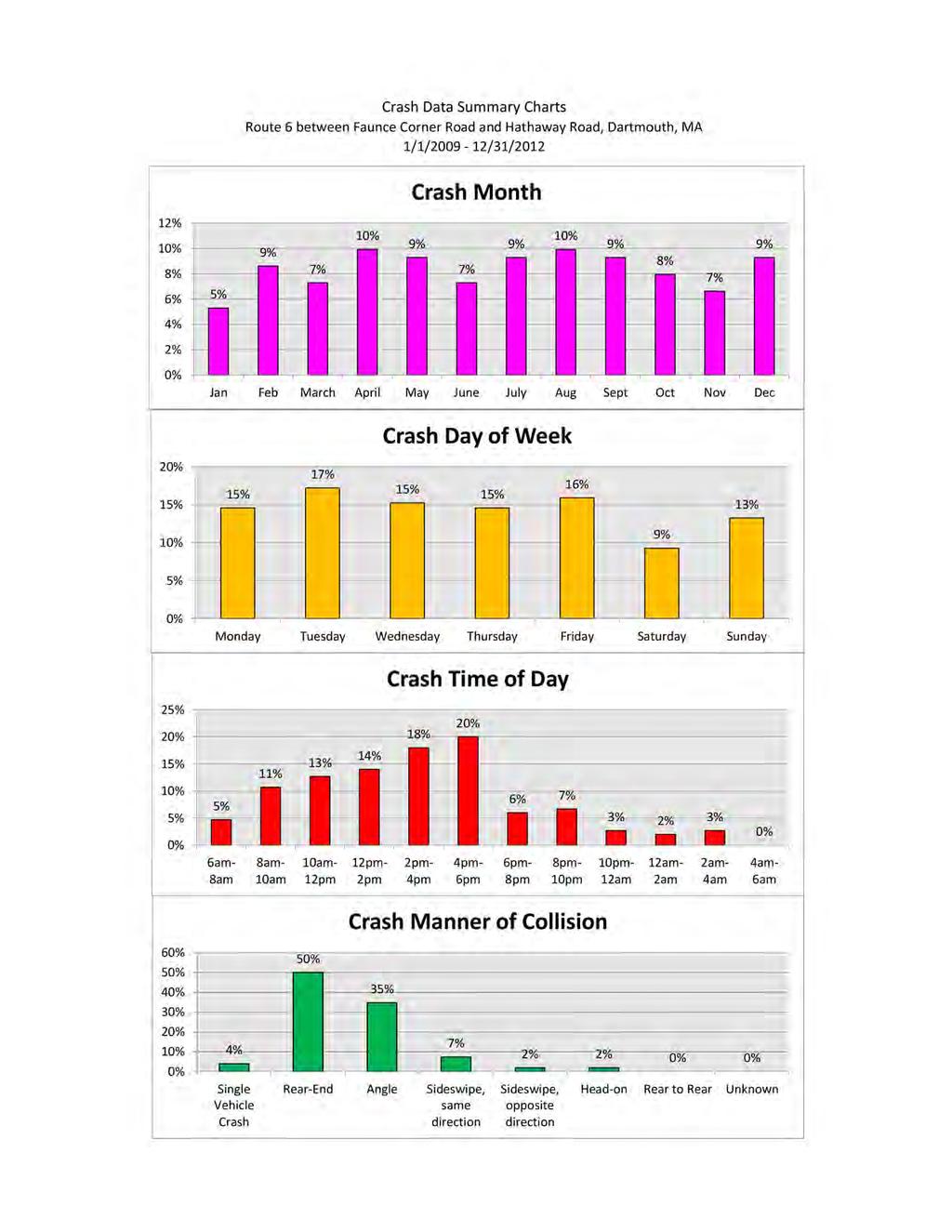
39
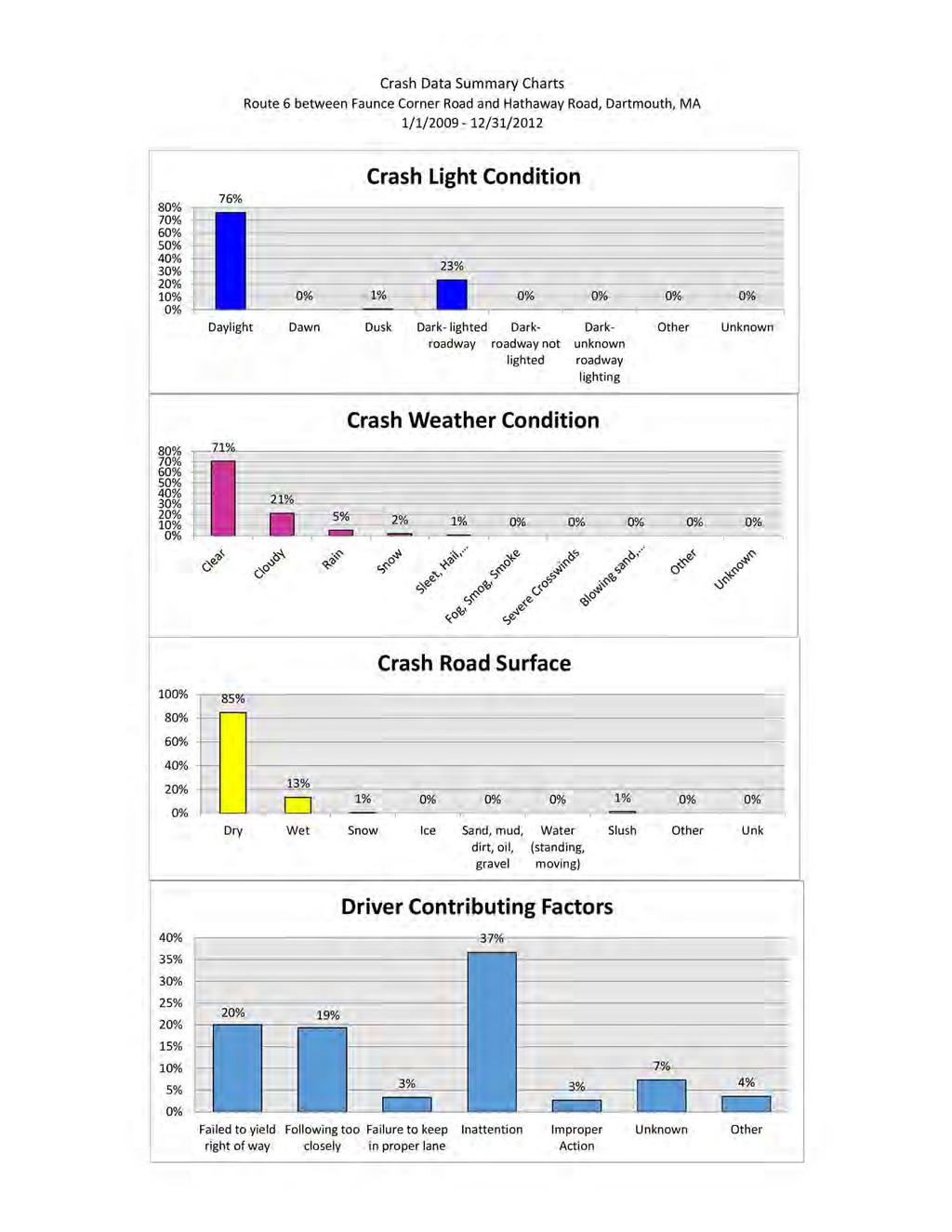
40
ROAD SAFETY AUDIT. Route 16 at Interstate 395 Town of Webster. October Prepared For: MassDOT
 ROAD SAFETY AUDIT Route 16 at Interstate 395 Town of Webster October 2015 Prepared For: MassDOT Prepared By: McMahon Associates, Inc. 300 Myles Standish Blvd. Suite 201 Taunton, MA 02780 Table of Contents
ROAD SAFETY AUDIT. Blue Hill Avenue (Route 28) and Warren Street High Crash Locations City of Boston. November 1, 2016
 and Warren Street High Crash Locations City of Boston. November 1, 2016") ROAD SAFETY AUDIT Blue Hill Avenue (Route 28) and Warren Street High Crash Locations City of Boston November 1, 2016 Prepared For: MassDOT Highway Division Prepared By: BETA Group, Inc. Table of Contents
ROAD SAFETY AUDIT Blue Hill Avenue (Route 28) and Warren Street High Crash Locations City of Boston November 1, 2016 Prepared For: MassDOT Highway Division Prepared By: BETA Group, Inc. Table of Contents
ROAD SAFETY AUDIT. Boston Road (Route 20) at Parker Street and Pasco Road to Dumaine Street City of Springfield Town of Wilbraham.
 at Parker Street and Pasco Road to Dumaine Street City of Springfield Town of Wilbraham.") ROAD SAFETY AUDIT Boston Road (Route 2) at Parker Street and Pasco Road to Dumaine Street City of Springfield Town of Wilbraham October 4, 212 Prepared For: MassDOT Highway Division Prepared By: BETA Group,
ROAD SAFETY AUDIT Boston Road (Route 2) at Parker Street and Pasco Road to Dumaine Street City of Springfield Town of Wilbraham October 4, 212 Prepared For: MassDOT Highway Division Prepared By: BETA Group,
ROAD SAFETY AUDIT. May 18, Prepared For: MassDOT. On Behalf Of: Town of Milford
 ROAD SAFETY AUDIT East Main Street (Route 16) at Medway Road (Route 109), East Main Street (Route 16) at Quarry Square Driveways, East Main Street (Route 16) at Beaver Street/ Fortune Boulevard Town of
ROAD SAFETY AUDIT. County Street at Hart Street. City of Taunton. January 30, Prepared For: Massachusetts Department of Transportation
 ROAD SAFETY AUDIT County Street at Hart Street City of Taunton January 30, 2015 Prepared For: Massachusetts Department of Transportation Prepared By: Toole Design Group 33 Broad Street, 4 th Floor Boston,
ROAD SAFETY AUDIT. Route 1 at Route 123 Route 1 at Route 1A Route 1 at May Street Route 1A and Route 123. City of Attleboro, MA. September 15, 2015
 ROAD SAFETY AUDIT Route 1 at Route 123 Route 1 at Route 1A Route 1 at May Street Route 1A and Route 123 City of Attleboro, MA September 15, 2015 Prepared For: MassDOT On Behalf Of: Prepared By: Fay, Spofford
ROAD SAFETY AUDIT. Granite Avenue at Interstate 93 Ramps. Town of Milton. May 22, Prepared for: MassDOT
 ROAD SAFETY AUDIT Granite Avenue at Interstate 93 Ramps Town of Milton May 22, 2017 Prepared for: MassDOT Prepared by: Toole Design Group 2 Oliver Street, Suite 305 Boston, MA 02109 Table of Contents Background...
ROAD SAFETY AUDIT. Centre Street (Route 123) at Plymouth Street. Municipality of Brockton. November, Prepared For: MassDOT
 at Plymouth Street. Municipality of Brockton. November, Prepared For: MassDOT") ROAD SAFETY AUDIT Centre Street (Route 123) at Plymouth Street Municipality of Brockton November, 2017 Prepared For: MassDOT On Behalf Of: City of Brockton Prepared By: Old Colony Planning Council 70 School
ROAD SAFETY AUDIT Centre Street (Route 123) at Plymouth Street Municipality of Brockton November, 2017 Prepared For: MassDOT On Behalf Of: City of Brockton Prepared By: Old Colony Planning Council 70 School
ROAD SAFETY AUDIT. Route 38 from Route 62 to Woburn Town Line. Town of Wilmington. April 10, Prepared For: MassDOT
 ROAD SAFETY AUDIT Route 38 from Route 62 to Woburn Town Line Town of Wilmington April 10, 2017 Prepared For: MassDOT Prepared By: Green International Affiliates, Inc. 239 Littleton Road, Suite 3, Westford,
ROAD SAFETY AUDIT. Route 202 (East State Street)/School Street & Route 202 (West State Street)/Pleasant Street/Amherst Street Town of Granby
/School Street & Route 202 (West State Street)/Pleasant Street/Amherst Street Town of Granby") ROAD SAFETY AUDIT Route 202 (East State Street)/School Street & Route 202 (West State Street)/Pleasant Street/Amherst Street Town of Granby March 2013 Prepared for: Massachusetts Department of Transportation
ROAD SAFETY AUDIT Route 202 (East State Street)/School Street & Route 202 (West State Street)/Pleasant Street/Amherst Street Town of Granby March 2013 Prepared for: Massachusetts Department of Transportation
Route 28 (South Orleans Road)/Route 39 (Harwich Road)/Quanset Road Intersection
/Route 39 (Harwich Road)/Quanset Road Intersection") TRAFFIC FEASIBILITY STUDY Route 28 (South Orleans Road)/Route 39 (Harwich Road)/Quanset Road Intersection Orleans, Massachusetts Prepared for: Town of Orleans Prepared by: Fay, Spofford & Thorndike, LLC
TRAFFIC FEASIBILITY STUDY Route 28 (South Orleans Road)/Route 39 (Harwich Road)/Quanset Road Intersection Orleans, Massachusetts Prepared for: Town of Orleans Prepared by: Fay, Spofford & Thorndike, LLC
ROAD SAFETY AUDIT. West Central Street (Route 140) at Franklin Village Drive. Town of Franklin. February 03, 2016
 at Franklin Village Drive. Town of Franklin. February 03, 2016") ROAD SAFETY AUDIT West Central Street (Route 140) at Franklin Village Drive Town of Franklin February 03, 2016 Prepared for: Massachusetts Department of Transportation Prepared by: Howard Stein Hudson
ROAD SAFETY AUDIT West Central Street (Route 140) at Franklin Village Drive Town of Franklin February 03, 2016 Prepared for: Massachusetts Department of Transportation Prepared by: Howard Stein Hudson
ROAD SAFETY AUDIT. Route 135 at Route 30 Town of Westborough. January Prepared For: MassDOT
 ROAD SAFETY AUDIT Route 135 at Route 30 January 2016 Prepared For: MassDOT Prepared By: McMahon Associates, Inc. 300 Myles Standish Blvd. Suite 201 Taunton, MA 02780 Road Safety Audit Route 135 at Route
AGENDA ITEM 6 D THOMASVILLE ROAD (HERMITAGE BOULEVARD TO LIVE OAK PLANTATION ROAD) ROADWAY SAFETY AUDIT
 ROADWAY SAFETY AUDIT") May 15, 2018 AGENDA ITEM 6 D THOMASVILLE ROAD (HERMITAGE BOULEVARD TO LIVE OAK PLANTATION ROAD) ROADWAY SAFETY AUDIT TYPE OF ITEM: Discussion STATEMENT OF ISSUE The Florida Department of Transportation
May 15, 2018 AGENDA ITEM 6 D THOMASVILLE ROAD (HERMITAGE BOULEVARD TO LIVE OAK PLANTATION ROAD) ROADWAY SAFETY AUDIT TYPE OF ITEM: Discussion STATEMENT OF ISSUE The Florida Department of Transportation
ROAD SAFETY AUDIT. Route 114 at Interstate I-495 Northbound Ramps. City of Lawrence. July 30, 2015
 ROAD SAFETY AUDIT Route 114 at Interstate I-495 Northbound Ramps City of Lawrence July 30, 2015 Prepared For: Massachusetts Department of Transportation Prepared By: Toole Design Group 33 Broad Street,
FLORIDA DEPARTMENT OF TRANSPORTATION DISTRICT 7 DISTRICT WIDE BICYCLE/PEDESTRIAN ACCESS TO TRANSIT SAFETY ASSESSMENT AND IMPROVEMENT PLAN
 FLORIDA DEPARTMENT OF TRANSPORTATION DISTRICT 7 DISTRICT WIDE BICYCLE/PEDESTRIAN ACCESS TO TRANSIT SAFETY ASSESSMENT AND IMPROVEMENT PLAN TRANSIT SAFETY ASSESSMENT SR 55/US 19 AT 80 TH AVE N DRAFT JUNE
ROAD SAFETY AUDIT. Route 18 (Bedford Street) from Whitman Street to Central Square Town of East Bridgewater. May 14, 2014
 from Whitman Street to Central Square Town of East Bridgewater. May 14, 2014") ROAD SAFETY AUDIT Route 18 (Bedford Street) from Whitman Street to Central Square Town of East Bridgewater May 14, 2014 Prepared For: MassDOT Highway Division Prepared By: BETA Group, Inc. Table of Contents
ROAD SAFETY AUDIT Route 18 (Bedford Street) from Whitman Street to Central Square Town of East Bridgewater May 14, 2014 Prepared For: MassDOT Highway Division Prepared By: BETA Group, Inc. Table of Contents
ROAD SAFETY AUDIT. Falmouth Road (Route 28)/Bearses Way. Town of Barnstable. May Prepared for: Massachusetts Highway Department
/Bearses Way. Town of Barnstable. May Prepared for: Massachusetts Highway Department") ROAD SAFETY AUDIT Falmouth Road (Route 28)/Bearses Way Town of Barnstable May 2009 Prepared for: Massachusetts Highway Department Prepared by: Howard/Stein-Hudson Associates 38 Chauncy Street Boston, MA
ROAD SAFETY AUDIT Falmouth Road (Route 28)/Bearses Way Town of Barnstable May 2009 Prepared for: Massachusetts Highway Department Prepared by: Howard/Stein-Hudson Associates 38 Chauncy Street Boston, MA
Multi-Modal Traffic Analysis. Parisi and Associates
 Mill Valley to Corte Madera Bicycle and Pedestrian Corridor Study Appendix D: Multi-Modal Traffic Analysis Prepared by Parisi and Associates August 2009 Appendix D - Multi-Modal Traffic Analysis Table
ROAD SAFETY AUDIT. Mass Pike Interchange 6, I-291 and Burnett Road. City of Chicopee. November 4, Prepared For: MassDOT Highway Division
 ROAD SAFETY AUDIT Mass Pike Interchange 6, I-291 and Burnett Road City of Chicopee November 4, 2013 Prepared For: MassDOT Highway Division Prepared By: BETA Group, Inc. Table of Contents Project Data...
ROAD SAFETY AUDIT. Rourke Bridge at Pawtucket Boulevard (Route 113) City of Lowell. October 5, Prepared For: MassDOT.
 City of Lowell. October 5, Prepared For: MassDOT.") ROAD SAFETY AUDIT Rourke Bridge at Pawtucket Boulevard (Route 113) City of Lowell October, 2017 Prepared For: MassDOT Prepared By: Vanasse Hangen Brustlin, Inc 101 Walnut Street Watertown, MA 02472 Road
ROAD SAFETY AUDIT Rourke Bridge at Pawtucket Boulevard (Route 113) City of Lowell October, 2017 Prepared For: MassDOT Prepared By: Vanasse Hangen Brustlin, Inc 101 Walnut Street Watertown, MA 02472 Road
ROAD SAFETY AUDIT. Route 3A from Evans Street to Abigail Adams State Park. Town of Weymouth. October 12, Prepared For: MassDOT
 ROAD SAFETY AUDIT Route 3A from Evans Street to Abigail Adams State Park Town of Weymouth October 12, 2016 Prepared For: MassDOT Prepared By: Green International Affiliates, Inc. 239 Littleton Road, Suite
ROAD SAFETY AUDIT. Plain Street (Route 139) at Furnace Street and Proprietors Drive Town of Marshfield. June 9, 2017.
 at Furnace Street and Proprietors Drive Town of Marshfield. June 9, 2017.") ROAD SAFETY AUDIT Plain Street (Route 139) at Furnace Street and Proprietors Drive Town of Marshfield June 9, 2017 Prepared for: MassDOT On Behalf of: Vanasse & Associates, Inc. 35 New England Business
ROAD SAFETY AUDIT Plain Street (Route 139) at Furnace Street and Proprietors Drive Town of Marshfield June 9, 2017 Prepared for: MassDOT On Behalf of: Vanasse & Associates, Inc. 35 New England Business
Evaluation of M-99 (Broad Street) Road Diet and Intersection Operational Investigation
 Road Diet and Intersection Operational Investigation") Evaluation of M-99 (Broad Street) Road Diet and Intersection Operational Investigation City of Hillsdale, Hillsdale County, Michigan June 16, 2016 Final Report Prepared for City of Hillsdale 97 North Broad
Evaluation of M-99 (Broad Street) Road Diet and Intersection Operational Investigation City of Hillsdale, Hillsdale County, Michigan June 16, 2016 Final Report Prepared for City of Hillsdale 97 North Broad
ROAD SAFETY AUDIT. South Street (Route 1A) at East Bacon Street (Route 106) and West Bacon Street Town of Plainville.
 at East Bacon Street (Route 106) and West Bacon Street Town of Plainville.") ROAD SAFETY AUDIT South Street (Route 1A) at East Bacon Street (Route 106) and West Bacon Street Town of Plainville March 15, 2018 Prepared For: MassDOT On Behalf Of: Town of Plainville Prepared By: BETA
ROAD SAFETY AUDIT South Street (Route 1A) at East Bacon Street (Route 106) and West Bacon Street Town of Plainville March 15, 2018 Prepared For: MassDOT On Behalf Of: Town of Plainville Prepared By: BETA
ROAD SAFETY AUDIT. Russell Street (Route 9) at North and South Maple Streets Town of Hadley. March 2014
 at North and South Maple Streets Town of Hadley. March 2014") ROAD SAFETY AUDIT Russell Street (Route 9) at North and South Maple Streets Town of Hadley March 2014 Prepared for: Massachusetts Department of Transportation Prepared by: Howard/Stein-Hudson Associates
ROAD SAFETY AUDIT Russell Street (Route 9) at North and South Maple Streets Town of Hadley March 2014 Prepared for: Massachusetts Department of Transportation Prepared by: Howard/Stein-Hudson Associates
Off-road Trails. Guidance
 Off-road Trails Off-road trails are shared use paths located on an independent alignment that provide two-way travel for people walking, bicycling, and other non-motorized users. Trails specifically along
ROAD SAFETY AUDIT. Route 53 (Washington Street) High Crash Locations at Route 139 (Schoosett Street) and Route 14 (Congress Street) Town of Pembroke
 High Crash Locations at Route 139 (Schoosett Street) and Route 14 (Congress Street) Town of Pembroke") ROAD SAFETY AUDIT Route 53 (Washington Street) High Crash Locations at Route 139 (Schoosett Street) and Route 14 (Congress Street) Town of Pembroke April 29, 2016 Prepared For: MassDOT Highway Division
ROAD SAFETY AUDIT Route 53 (Washington Street) High Crash Locations at Route 139 (Schoosett Street) and Route 14 (Congress Street) Town of Pembroke April 29, 2016 Prepared For: MassDOT Highway Division
ROAD SAFETY AUDIT. Providence Street (Route 122A) at McKeon Road/Millbury Street. City of Worcester. July 14, Prepared For: MassDOT
 at McKeon Road/Millbury Street. City of Worcester. July 14, Prepared For: MassDOT") ROAD SAFETY AUDIT Providence Street (Route 122A) at McKeon Road/Millbury Street City of Worcester July 14, 2016 Prepared For: MassDOT Prepared By: Stantec Consulting Services, Inc. Burlington, Massachusetts
ROAD SAFETY AUDIT Providence Street (Route 122A) at McKeon Road/Millbury Street City of Worcester July 14, 2016 Prepared For: MassDOT Prepared By: Stantec Consulting Services, Inc. Burlington, Massachusetts
Orange Center Elementary School
 Drag and drop pic and stretch/crop to the limits of the blue rectangle (delete this text box) Orange Center Elementary School Drag and drop pic and stretch/crop to the limits of the blue rectangle (delete
ROAD SAFETY AUDIT. Damon Road. City of Northampton. October Prepared for: Massachusetts Department of Transportation
 ROAD SAFETY AUDIT Damon Road City of Northampton October 2013 Prepared for: Massachusetts Department of Transportation Prepared by: Howard/Stein-Hudson Associates 38 Chauncy Street Boston, MA 02111 Table
TRAFFIC IMPACT ANALYSIS
 TRAFFIC IMPACT ANALYSIS FOR THE CHAMPAIGN UNIT#4 SCHOOL DISTRICT PROPOSED HIGH SCHOOL (SPALDING PARK SITE) IN THE CITY OF CHAMPAIGN Final Report Champaign Urbana Urbanized Area Transportation Study 6/24/2014
sm1 CDMth '}lf!j1i!~~!2q[ ROAD SAFETY AUDIT County Street City of New Bedford March 22, 2017 Prepared For: MassDOT
 ROAD SAFETY AUDIT County Street City of New Bedford March 22, 2017 '}lf!j1i!~~!2q[ ~ j ighway Divl.sion Prepared For: MassDOT On Behalf Of: City of New Bedford Massachusetts Prepared By: CDM Smith 260
M-58 HIGHWAY ACCESS MANAGEMENT STUDY Mullen Road to Bel-Ray Boulevard. Prepared for CITY OF BELTON. May 2016
 M-58 HIGHWAY ACCESS MANAGEMENT STUDY Prepared for CITY OF BELTON By May 2016 Introduction Missouri State Highway 58 (M-58 Highway) is a major commercial corridor in the City of Belton. As development has
ROAD SAFETY AUDIT MDM. Columbia Road at Dorchester Avenue. Dorchester, MA 10/14/2016. Prepared For: MassDOT. On Behalf Of: Edens
 ROAD SAFETY AUDIT Columbia Road at Dorchester Avenue Dorchester, MA 10/14/2016 Prepared For: MassDOT On Behalf Of: Edens Prepared By: MDM Transportation Consultants, Inc. 28 Lord Road Suite 280 Marlborough,
ROAD SAFETY AUDIT. Route 113 (Storey Avenue) at Woodman Way and Low Street. Newburyport, MA. May 27, Prepared For: MassDOT
 at Woodman Way and Low Street. Newburyport, MA. May 27, Prepared For: MassDOT") ROAD SAFETY AUDIT Route 113 (Storey Avenue) at Woodman Way and Low Street Newburyport, MA May 27, 2015 Prepared For: MassDOT Prepared By: Bayside Engineering, Inc. 600 Unicorn Park Drive Woburn, MA 01801
ROAD SAFETY AUDIT Route 113 (Storey Avenue) at Woodman Way and Low Street Newburyport, MA May 27, 2015 Prepared For: MassDOT Prepared By: Bayside Engineering, Inc. 600 Unicorn Park Drive Woburn, MA 01801
ROAD SAFETY AUDIT. Northampton Road (Route 9) at University Drive and Snell Street Town of Amherst. November 15, Prepared For: MassDOT
 at University Drive and Snell Street Town of Amherst. November 15, Prepared For: MassDOT") ROAD SAFETY AUDIT Northampton Road (Route 9) at University Drive and Snell Street Town of Amherst November 15, 2016 Prepared For: MassDOT Prepared By: Greenman-Pedersen, Inc. 181 Ballardvale Street, Suite
ROAD SAFETY AUDIT Northampton Road (Route 9) at University Drive and Snell Street Town of Amherst November 15, 2016 Prepared For: MassDOT Prepared By: Greenman-Pedersen, Inc. 181 Ballardvale Street, Suite
DEPARTMENT OF ENVIRONMENTAL SERVICES. North Harrison Street (Lee Highway to Little Falls Road) Comparative Analysis. Prepared for:
 Comparative Analysis. Prepared for:") DEPARTMENT OF ENVIRONMENTAL SERVICES North Harrison Street (Lee Highway to Little Falls Road) Comparative Analysis Prepared for: Arlington County Department of Environmental Services 2100 Clarendon Boulevard,
DEPARTMENT OF ENVIRONMENTAL SERVICES North Harrison Street (Lee Highway to Little Falls Road) Comparative Analysis Prepared for: Arlington County Department of Environmental Services 2100 Clarendon Boulevard,
Traffic Study of Fuller Street, Cady Street, West Street and West Avenue. Final Report
 Traffic Study of Fuller Street, Cady Street, West Street and West Avenue Final Report July 2005 Prepared for: Town of Ludlow Prepared by: Pioneer Valley Planning Commission 26 Central Street West Springfield,
10.0 CURB EXTENSIONS GUIDELINE
 10.0 CURB EXTENSIONS GUIDELINE Road Engineering Design Guidelines Version 1.0 March 2017 City of Toronto, Transportation Services City of Toronto Page 0 Background In early 2014, Transportation Services
MEMORANDUM. Date: 9/13/2016. Citywide Crosswalk Policy
 MEMORANDUM Date: 9/13/2016 Re: Citywide Crosswalk Policy Foreword Through the s Circulation Element and Complete Streets Policy, it is the City s goal to promote walking trips and provide safe facilities
ALLEY 24 TRAFFIC STUDY
 ALLEY 24 TRAFFIC STUDY in City of Frostburg, Maryland January 2013 3566 Teays Valley Road Hurricane, WV Office: (304) 397-5508 www.denniscorporation.com Alley 24 Traffic Study January 2013 Frostburg, Maryland
Date: April 4, Project #: Re: A Street/Binford Street Traffic/Intersection Assessment
 To: Peter Cavanaugh General Electric From: David Bohn, PE Ryan White, PE Date: April 4, 217 Project #: 13421. Re: / Traffic/Intersection Assessment Consistent with the Cooperation Agreement between the
Active Transportation Facility Glossary
 Active Transportation Facility Glossary This document defines different active transportation facilities and suggests appropriate corridor types. Click on a facility type to jump to its definition. Bike
Chapter 2: Standards for Access, Non-Motorized, and Transit
 Standards for Access, Non-Motorized, and Transit Chapter 2: Standards for Access, Non-Motorized, and Transit The Washtenaw County Access Management Plan was developed based on the analysis of existing
Ottawa Beach Road Study
 Ottawa Beach Road Study Prepared For: Park Township September 30, 2014 Project No. G140303 OTTAWA BEACH ROAD STUDY PREPARED FOR: PARK TOWNSHIP SEPTEMBER 30, 2014 PROJECT NO. G140303 TABLE OF CONTENTS 1.0
Windy Ridge Elementary School
 Windy Ridge Elementary School SCHOOL ROUTE PLAN For WINDY RIDGE ELEMENTARY SCHOOL LOCATION 54 ORANGE COUNTY Prepared for: ORANGE COUNTY SCHOOL ASSESSMENT PROGRAM ORANGE COUNTY PUBLIC WORKS Traffic Engineering
MEMORANDUM. Nantasket Road at Kingsley Road Kingsley Road at Sumner Street Kingsley Road at Revere Street Kingsley Road at Kenberma Street
 MEMORANDUM Date: June 28, 2012 To: From: Subject: Mr. Joseph Stigliani, Director of Public Works Kenneth J. Petraglia, P.E., PTOE Greg E. Lucas, P.E., PTOE Kingsley Road Stop Sign Warrant Analysis BETA
Appendix T CCMP TRAIL TRAFFIC & TRANSPORTATION DESIGN STANDARD
 Appendix T CCMP 3.3.4 TRAIL TRAFFIC & TRANSPORTATION DESIGN STANDARD 3.3.4 Trail Traffic and Transportation Design Multi-use trails have certain design standards, which vary depending on the agency that
Meadow Woods Elementary School
 Drag and drop pic and stretch/crop to the limits of the blue rectangle (delete this text box) Meadow Woods Elementary School Drag and drop pic and stretch/crop to the limits of the blue rectangle (delete
ROAD SAFETY AUDIT. East Main Street (Route 123) at Route I-495 Northbound & Southbound Ramps Town of Norton. May 11, Prepared For: MassDOT
 at Route I-495 Northbound & Southbound Ramps Town of Norton. May 11, Prepared For: MassDOT") ROAD SAFETY AUDIT East Main Street (Route 123) at Route I-495 Northbound & Southbound Ramps Town of Norton May 11, 2016 Prepared For: MassDOT Prepared By: 101 Walnut Street Watertown, MA Road Safety Audit
ROAD SAFETY AUDIT East Main Street (Route 123) at Route I-495 Northbound & Southbound Ramps Town of Norton May 11, 2016 Prepared For: MassDOT Prepared By: 101 Walnut Street Watertown, MA Road Safety Audit
Caltrans Sloat Boulevard Pedestrian Safety Project Response to Community Questions, Comments & Concerns
 Caltrans Sloat Boulevard Pedestrian Safety Project Response to Community Questions, Comments & Concerns Revised: May 10, 2016 The California Department of Transportation (Caltrans) is planning various
Summary: Mercer County Princeton Avenue & Spruce Street Study January 2009
 Summary: Several recent studies have assessed potential development and redevelopment opportunities in the Mercer Crossing area of Trenton, Ewing, and Lawrence. This Princeton Avenue and Spruce Street
Best Practices for the Design and Operation of Reduced Conflict Intersections
 Best Practices for the Design and Operation of Reduced Conflict Intersections OCTOBER 2016 Prepared By: Table of Contents INTRODUCTION... 5 Purpose... 5 Definition... 5 Advantages... 6 Disadvantages...
A plan for improved motor vehicle access on Railroad Avenue in Provincetown
 A plan for improved motor vehicle access on Railroad Avenue in Provincetown February 2011 A plan for improved motor vehicle access on Railroad Avenue in Provincetown INTRODUCTION AND PROBLEM IDENTIFICATION
Broad Street Bicycle Boulevard Design Guidelines
 Broad Street Bicycle Boulevard Design Guidelines Building from the strategies introduced in the 2013 Bicycle Transportation Plan and community input received thus far, City Transportation Staff have identified
MEMORANDUM. Layout Of Study Intersections And Traffic Control
 BOSTON REGION METROPOLITAN PLANNING ORGANIZATION Richard A. Davey, MassDOT Secretary and CEO and MPO Chairman Karl H. Quackenbush, Executive Director, MPO Staff DATE November 15, 2012 TO FROM RE Town of
ROAD SAFETY AUDIT. Washington Street (Route 53) at Pleasant Street. Town of Pembroke. June 26, Prepared For: MassDOT Highway Division
 at Pleasant Street. Town of Pembroke. June 26, Prepared For: MassDOT Highway Division") ROAD SAFETY AUDIT Washington Street (Route 53) at Pleasant Street Town of Pembroke June 26, 2014 Prepared For: MassDOT Highway Division Prepared By: BETA Group, Inc. Table of Contents Project Data... 1
ROAD SAFETY AUDIT Washington Street (Route 53) at Pleasant Street Town of Pembroke June 26, 2014 Prepared For: MassDOT Highway Division Prepared By: BETA Group, Inc. Table of Contents Project Data... 1
ROAD SAFETY AUDIT. Route 1 at Everett Street & University Avenue. Town of Norwood. September Prepared For: On Behalf Of:
 ROAD SAFETY AUDIT Route 1 at Everett Street & University Avenue Town of Norwood September 2014 Prepared For: On Behalf Of: Westwood Marketplace Holdings LLC Prepared By: 35 New England Business Center
TRAFFIC ACTION PLAN. Laurie Meadows Neighborhood CITY OF SAN MATEO
 TRAFFIC ACTION PLAN Laurie Meadows Neighborhood CITY OF SAN MATEO Draft January 2017 Table of Contents Introduction... 2 The Traffic Forum Process... 5 Neighborhood Traffic Issues... 7 Neighborhood Recommendations
Forest Hills Improvement Initiative
 Forest Hills Improvement Initiative Transportation Action Plan Short Term Recommendations ONLY Final Draft as of April 30, 2008 For Community Review and Feedback Prepared for: The City of Boston Boston
ROAD SAFETY AUDIT. Water Street (Route 129) at Vernon Street. Town of Wakefield. September Prepared For: MassDOT
 at Vernon Street. Town of Wakefield. September Prepared For: MassDOT") ROAD SAFETY AUDIT Water Street (Route 129) at Vernon Street September 2017 Prepared For: MassDOT Massachusetts Department of Transportation Prepared By: WorldTech Engineering Road Safety Audit Water Street
ROAD SAFETY AUDIT Water Street (Route 129) at Vernon Street September 2017 Prepared For: MassDOT Massachusetts Department of Transportation Prepared By: WorldTech Engineering Road Safety Audit Water Street
Coquitlam Cross-town Bike Route Improving Bicycle Facilities in a Mature Suburban Environment
 Coquitlam Cross-town Bike Route Improving Bicycle Facilities in a Mature Suburban Environment Sarah Rocchi, Vice-President, Projects, Opus International Consultants (Main Presenter) Catherine Mohoruk,
Draft North Industrial Area-Wide Traffic Plan
 Summary of North Industrial and Hudson Bay Industrial Recommended Improvements Table 1. Summary of s Item Location 1 2 3 4 5 6 7 8 9 10 11 12 Millar Ave north of 51st St Super 8 Motel back lane 400 Block
Access Management in the Vicinity of Intersections
 Access Management in the Vicinity of Intersections FHWA-SA-10-002 Technical Summary Photo: Ralph Bentley (used with permission) 0 Access Management is: The design, implementation and management of entry
CHAPTER 1 STANDARD PRACTICES
 CHAPTER 1 STANDARD PRACTICES OBJECTIVES 1) Functions and Limitations 2) Standardization of Application 3) Materials 4) Colors 5) Widths and Patterns of Longitudinal Pavement Marking Lines 6) General Principles
CAPE COD COMMISSION 3225 MAIN STREET P.O. BOX 226 BARNSTABLE, MA (508) Fax (508) Transportation Safety Report
 Fax (508) Transportation Safety Report") CAPE COD COMMISSION 3225 MAIN STREET P.O. BOX 226 BARNSTABLE, MA 02630 (508) 362-3828 Fax (508) 362-3136 2006 Transportation Safety Report Bourne: Otis Rotary Harwich: Route 137/Route 39 Orleans: Route
CAPE COD COMMISSION 3225 MAIN STREET P.O. BOX 226 BARNSTABLE, MA 02630 (508) 362-3828 Fax (508) 362-3136 2006 Transportation Safety Report Bourne: Otis Rotary Harwich: Route 137/Route 39 Orleans: Route
Dartmouth. Faunce Corner Road/Route 6. Congestion Study
 Dartmouth Faunce Corner Road/Route 6 Congestion Study SOUTHEASTERN MASSACHUSETTS METROPOLITAN PLANNING ORGANIZATION SOUTHEASTERN REGIONAL PLANNING & ECONOMIC DEVELOPMENT DISTRICT October 2007 Southeastern
Access Location, Spacing, Turn Lanes, and Medians
 Design Manual Chapter 5 - Roadway Design 5L - Access Management 5L-3 Access Location, Spacing, Turn Lanes, and Medians This section addresses access location, spacing, turn lane and median needs, including
BOSTON REGION METROPOLITAN PLANNING ORGANIZATION MEMORANDUM. DATE June 2, 2011
 BOSTON METROPOLITAN PLANNING ORGANIZATION State Transportation Building Ten Park Plaza, Suite 2150 Boston, MA 02116-3968 Tel. (617) 973-7100 Fax (617) 973-8855 TTY (617) 973-7089 www.bostonmpo.org Jeffrey
CURBSIDE ACTIVITY DESIGN
 5 CURBSIDE ACTIVITY DESIGN This chapter provides design guidance for separated bike lanes adjacent to curbside activities including parking, loading and bus stops. Typical configurations are presented
Road Safety Audit for the Intersection of VFW Highway & Bridge Street in Lowell, Massachusetts
 Road Safety Audit for the Intersection of VFW Highway & Bridge Street in Lowell, Massachusetts Prepared by University of Massachusetts Traffic Safety Research Program Prepared for Massachusetts Highway
THIS PAGE LEFT BLANK INTENTIONALLY
 GA SR 25 Spur at Canal Road Transportation Impact Analysis PREPARED FOR GLYNN COUNTY, GEORGIA 1725 Reynolds Street, Suite 300 Brunswick, Georgia 31520 PREPARED BY 217 Arrowhead Boulevard Suite 26 Jonesboro,
TRAFFIC ACCIDENT ANALYSIS
 TRAFFIC ACCIDENT ANALYSIS Westheimer at Chimney Rock and Westheimer at Dunvale Prepared for Prepared by Klotz Associates, Inc. 1160 Dairy Ashford, Suite 500 Houston, Texas 77079 The preparation of this
City of Albert Lea Policy and Procedure Manual 4.10 ALBERT LEA CROSSWALK POLICY
 4.10 ALBERT LEA CROSSWALK POLICY PURPOSE: Pedestrian crosswalks are an integral part of our transportation infrastructure. To be effective and promote safety, marked crosswalks must be installed after
Route 117 Review of Ownership Transfer October 2014
 Route 117 Review of Ownership Transfer October 2014 Page 1 of 27 I. INTRODUCTION... 3 II. EXISTING CONDITIONS... 4 A. Town of Lancaster Site-Investigation... 4 B. Town of Bolton Site-Investigation... 9
ROAD SAFETY AUDIT. Needham Street and Highland Avenue Corridor. City of Newton and Town of Needham. March 2014
 ROAD SAFETY AUDIT Needham Street and Highland Avenue Corridor City of Newton and Town of Needham March 2014 Prepared for: Massachusetts Department of Transportation Prepared by: Howard/Stein-Hudson Associates
Appendix C. TRAFFIC CALMING PROGRAM TOOLBOX
 Appendix C. TRAFFIC CALMING PROGRAM TOOLBOX PHASE I...2 Do Not Enter Sign...3 One-Way Sign...4 Turn Prohibition...5 Pavement Markings...6 Speed Monitoring Trailer...7 Neighborhood Speed Watch...8 Police
Traffic Impact Analysis Chatham County Grocery Chatham County, NC
 Chatham County Grocery Chatham County, NC TABLE OF CONTENTS 1. INTRODUCTION... 1 1.1. Location and Study Area... 1 1.2. Proposed Land Use and Access... 2 1.3. Adjacent Land Uses... 2 1.4. Existing ways...
ROAD SAFETY AUDIT. Santilli Circle and Sweetser Circle. Municipality of Everett. March 10, Prepared For: MassDOT
 ROAD SAFETY AUDIT Santilli Circle and Sweetser Circle Municipality of Everett Prepared For: MassDOT On Behalf Of: WYNN Design and Development Prepared By: AECOM 250 Apollo Drive Chelmsford, MA Road Safety
Everyone is a Pedestrian
 Everyone is a Pedestrian Improving Pedestrian Safety in Texas Transportation and Trinity River Project Committee 26 May 2015 Everyone is a Pedestrian Federal Highway Administration [ FHWA ] Programs to
ROAD SAFETY AUDIT. Neponset Street Rotary/Pendergast Circle. Town of Norwood. September Prepared For: On Behalf Of:
 ROAD SAFETY AUDIT Neponset Street Rotary/Pendergast Circle Town of Norwood September 2014 Prepared For: On Behalf Of: Westwood Marketplace Holdings LLC Prepared By: 35 New England Business Center Drive
Recommended Roadway Plan Section 2 - Land Development and Roadway Access
 Recommended Roadway Plan Section 2 - Land Development and Roadway Access SECTION 2 Land Development and Roadway Access 2.1 Land Use and Access Management The Federal Highway Administration (FHWA) defines
DRAFT. Corridor study. Honeysuckle Road. October Prepared for the City of Dothan, AL. Prepared by Gresham, Smith and Partners
 DRAFT Corridor study Honeysuckle Road October 2017 Prepared for the City of Dothan, AL Prepared by TABLE OF CONTENTS SECTION I... 1 STUDY SUMMARY... 1 INTRODUCTION... 1 CONCLUSIONS... 5 SECTION II... 7
Swamp Road Residents Study
 Swamp Road Residents Study SRRG Meeting with PennDot and Elected Officials Newtown and Wrightstown, PA April 25, 2008 Newtown Township Section of Swamp Road Limited Public Funds No reconstruction of a
MEMORANDUM. DATE March 1, 2012 TO Town of Milton Mark Abbott, Seth Asante, and Efi Pagitsas Boston Region MPO Staff
 MEMORANDUM DATE March 1, 212 TO Town of Milton FROM RE Mark Abbott, Seth Asante, and Efi Pagitsas Boston Region MPO Staff FFY 211 Safety and Operations Analyses at Selected Boston Region MPO Intersections:
ROAD SAFETY AUDIT. Route 2/Route 68 Interchange Rotary City of Gardner. August 3, Prepared For: MassDOT
 ROAD SAFETY AUDIT Route 2/Route 68 Interchange Rotary City of Gardner August 3, 2016 Prepared For: MassDOT Prepared By: Tetra Tech 100 Nickerson Avenue Marlborough, MA 01752 Road Safety Audit Route 2/Route
ROAD SAFETY AUDIT. Route 27 (Crescent Street)/Quincy Street/Massasoit Boulevard. City of Brockton. July 24,2013
/Quincy Street/Massasoit Boulevard. City of Brockton. July 24,2013") ROAD SAFETY AUDIT Route 27 (Crescent Street)/Quincy Street/Massasoit Boulevard City of Brockton July 24,2013 Prepared for: Massachusetts Department of Transportation Prepared by: Howard/Stein-Hudson Associates
ROAD SAFETY AUDIT Route 27 (Crescent Street)/Quincy Street/Massasoit Boulevard City of Brockton July 24,2013 Prepared for: Massachusetts Department of Transportation Prepared by: Howard/Stein-Hudson Associates
Pedestrian Road Safety Audit
 Pedestrian Road Safety Audit Middlebrook Road From Father Hurley Boulevard to Waring Station Road December 2017 Montgomery County Department of Transportation Table of Contents 1. Introduction... 1 1.1
MT. LEBANON COMPREHENSIVE PLAN UPDATE ELEVATING CONNECTIVITY FOR PEDESTRIANS AND CYCLISTS
 MT. LEBANON COMPREHENSIVE PLAN UPDATE ELEVATING CONNECTIVITY FOR PEDESTRIANS AND CYCLISTS Municipality of Mt. Lebanon, Allegheny County, Pennsylvania INTRODUCTION The Mt. Lebanon Comprehensive Plan Update
Transportation Planning Division
 Transportation Planning Division Presentation Outline Study Tasks Recap of Previous Meetings Data Collected Focus Areas within Study Limits Design Principles Tool Box Recommended Concepts Schedule Moving
Military Road Safety Improvements
 Military Road Safety Improvements 26 th Road North to 31 st Street North SUMMARY OF DATA REVIEW AND PRELIMINARY RECOMMENDATIONS Prepared for: Department of Environmental Services Traffic Engineering and
Truck Turning Study for Main Street Intersection, Orange
 Truck Turning Study for Main Street Intersection, Orange Franklin Regional Council of Governments September 2015 0 Truck Turning Study for Main Street Intersection, Orange September 2015 Prepared by: Franklin
PEDESTRIAN SAFETY IMPROVEMENT EVALUATION GUIDELINE FOR UNCONTROLLED CROSSINGS
 PEDESTRIAN SAFETY IMPROVEMENT EVALUATION GUIDELINE FOR UNCONTROLLED CROSSINGS Traffic Safety Engineering Division Updated: April 2018 EXECUTIVE SUMMARY NDOT Traffic Safety Engineering Division developed
DOWNTOWN TUPELO MAIN STREET: ROAD DIET STUDY
 DOWNTOWN TUPELO MAIN STREET: ROAD DIET STUDY Since mid-2009, RPM Transportation Consultants (RPM) has worked with the Downtown Tupelo Main Street Association to evaluate traffic conditions and potential
Developed by: The American Traffic Safety Services Association (ATSSA) 15 Riverside Parkway, Suite 100 Fredericksburg, VA
 15 Riverside Parkway, Suite 100 Fredericksburg, VA") Addendum Developed by: The American Traffic Safety Services Association (ATSSA) 15 Riverside Parkway, Suite 100 Fredericksburg, VA 22406-1022 800-272-8772 This material is based upon work supported by
Addendum Developed by: The American Traffic Safety Services Association (ATSSA) 15 Riverside Parkway, Suite 100 Fredericksburg, VA 22406-1022 800-272-8772 This material is based upon work supported by
CONTENTS EXECUTIVE SUMMARY 1
 CONTENTS CHAPTER PAGE EXECUTIVE SUMMARY 1 1 ISSUES AND PURPOSE OF THE ANALYSIS 2 1.1 Background 2 1.2 Analysis Area 2 1.3 Issues and Observations 3 1.4 Project and Public Meetings 3 2 LIST OF PREFERRED
TRANSPORTATION FACILITY PLANNING Waugh Chapel Road Maytime Drive to New Market Lane
 July 24, 2018 TRANSPORTATION FACILITY PLANNING Waugh Chapel Road Maytime Drive to New Market Lane DPWandYOU.com Making a difference, together Meeting Agenda Purpose of the project Overview of work conducted
Lake Whitney Elementary School
 Lake Whitney Elementary School SCHOOL ROUTE PLAN For LAKE WHITNEY ELEMENTARY SCHOOL LOCATION 18 ORANGE COUNTY Prepared for: ORANGE COUNTY SCHOOL ASSESSMENT PROGRAM ORANGE COUNTY PUBLIC WORKS Traffic Engineering
Donahue Drive Corridor Traffic Operational Evaluation
 Donahue Drive Corridor Traffic Operational Evaluation PREPARED FOR: THE CITY OF AUBURN PREPARED BY: JANUARY 2007 Donahue Drive Corridor Study--Auburn, Alabama TABLE OF CONTENTS Introduction... 1 Background