ROAD SAFETY AUDIT. Route 16 at Interstate 395 Town of Webster. October Prepared For: MassDOT
|
|
|
- Kristopher Hoover
- 6 years ago
- Views:
Transcription
1 ROAD SAFETY AUDIT Route 16 at Interstate 395 Town of Webster October 2015 Prepared For: MassDOT Prepared By: McMahon Associates, Inc. 300 Myles Standish Blvd. Suite 201 Taunton, MA 02780
2 Table of Contents Background... 1 Project Data... 1 Project Location and Description... 3 Road Safety Audit Observations and Potential Improvements... 5 Recommendations List of Appendices Appendix A. Appendix B. Appendix C. RSA Meeting Agenda RSA Audit Team Contact List Detailed Crash Data List of Figures Figure 1: Location Map... 2 List of Tables Table 1. Participating Audit Team Members... 3 Table 2. Estimated Time Frame and Costs Breakdown Table 3. Potential Safety Enhancement Summary... 14
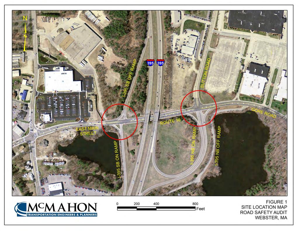
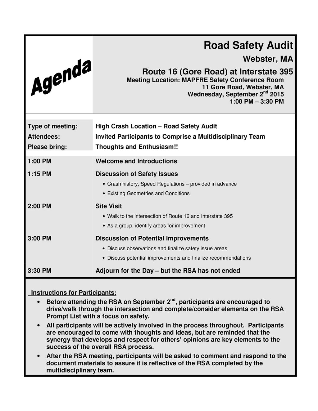
3 Background The Federal Highway Administration (FHWA) defines a Road Safety Audit (RSA) as the formal safety examination of an existing or future road or intersection by an independent, multidisciplinary team. The purpose of an RSA is to identify potential safety issues and possible opportunities for safety improvements considering all roadway users. This RSA evaluates the following intersections on Route 16 in Webster, MA, as shown in Figure 1: Route 16 (East Main Street) at Interstate 395 South Ramps Route 16 (Gore Road) at Sutton Road and Interstate 395 North Ramps A safety audit was scheduled for these intersections at the request of MassDOT and MAPFRE Insurance, whose headquarters are located adjacent to these intersections. The intersections of Route 16 at Interstate 395 South and Interstate 395 North were identified as Highway Safety Improvement Program (HSIP) highcrash intersections from A key objective of the RSA is to identify both short-term and long-term safety improvements that can be made at the subject intersections. Project Data A Road Safety Audit was completed for the intersections of Route 16 at Interstate 395 North and Interstate 395 South in the Town of Webster on September 2, The agenda for the RSA meeting held in the MAPFRE Insurance Safety Conference Room is provided in Appendix A of this report. As shown below in Table 1, the audit team consisted of a multidisciplinary team with representatives from state, regional and local agencies providing expertise in the engineering, planning, and maintenance fields. Contact information for the RSA attendees is provided in Appendix B of this report. Page 1
4
5 Table 1. Participating Audit Team Members Audit Team Member Agency/Affiliation William Ullom MassDOT Traffic Operations John Mastera MassDOT Highway Safety Rebecca Hansen McMahon Associates Phil Viveiros McMahon Associates Joe Frawley MassDOT District 3 Scott D. Charpentier Town of Webster Mark Giro MAPFRE Insurance Derrick Provencher MAPFRE Insurance Peter Gagliardo MAPFRE Insurance Tom Zona Massachusetts State Police Dan Daniska Central Massachusetts Regional Planning Commission Yahaira Graxirena Central Massachusetts Regional Planning Commission Promise Otaluka Federal Highway Administration Kenny Pizzetti Webster Highway Department Timothy Bent Webster Police Robert Blackmer MAPFRE Insurance William Prout MAPFRE Insurance Within the invitation sent on August 19, 2015 to each participant in the RSA, background material was provided. This information included collision diagrams and crash data summaries. During the RSA meeting, these materials were reviewed as a group before the team discussed potential safety issues and solutions for the intersection. Project Location and Description Study Area Roadways As shown in Figure 1, Route 16 is a two-lane, two-way roadway that runs in an east-west direction in the vicinity of the study area. Route 16 does not have speed limit signage; however, an RSA participant from the Town of Webster stated that the prima facie speed limit in Webster is 30 miles per hour on streets without speed limit signage. A comment submitted after the RSA noted that the prima facie speed limit is defined by MGL Chapter 90, Section 17, where 30 miles per hour is only applicable in thickly settled areas, which does not apply to the area of study. Route 16 is classified as a rural major collector under MassDOT jurisdiction. Within the vicinity of the Interstate 395 South off-ramp and on-ramp, Route 16 is approximately 40 feet wide with a designated left turn lane for westbound vehicles traveling towards Interstate 395 South. At the intersection of Route 16 with Sutton Road and the Interstate 395 North ramps, Route 16 is approximately 45 feet wide with exclusive left turn lanes for vehicles traveling in both the eastbound and westbound directions. There is an existing sidewalk on the south side of Route 16; however, the Webster Highway Superintendent surmised that it is likely a maintenance sidewalk due to its width and inaccessibility. RSA participants from the Town of Webster stated that Route 16 is utilized by cyclists, but there are no current bicycle facilities within the study area. Page 3
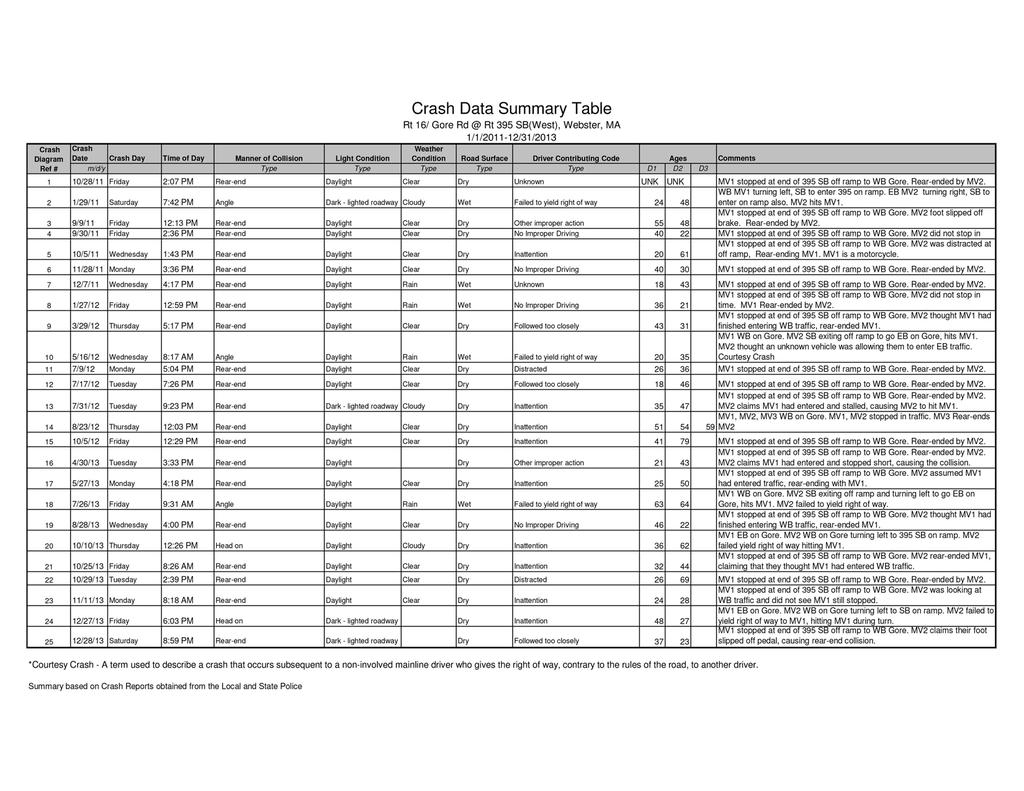
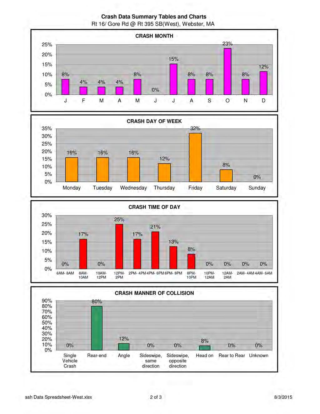
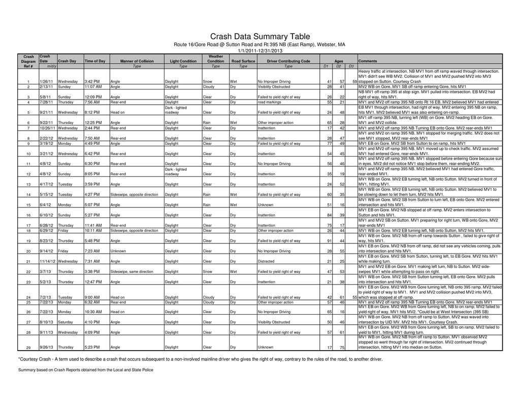
6 The Interstate 395 South off-ramp intersects Route 16 to the west of the Interstate 395 bridge decks. The off-ramp has two separated stop-controlled lanes for vehicles turning eastbound and westbound onto Route 16. The Interstate 395 South on-ramp is accessed by two lanes, one for westbound vehicles turning left and one for eastbound vehicles turning right. The Interstate 395 North on-ramp and off-ramp intersect Route 16 from the south, east of the Interstate 395 bridge decks. The off-ramp has a stop-controlled lane for vehicles traveling westbound onto Route 16 or northbound onto Sutton Road and a yield-controlled lane for vehicles traveling eastbound onto Route 16. The Interstate 395 North on-ramp is accessed by two lanes, one for westbound vehicles turning right and one for eastbound vehicles turning left or southbound vehicles from Sutton Road continuing onto Interstate 395 North. Sutton Road is a two-way roadway classified as a rural major collector under Town of Webster jurisdiction that runs generally in a north-south direction in the study area. Sutton Road has a single travel lane in each direction and provides access to commercial and industrial land uses. There is no parking or sidewalks on either side of Sutton Road. Sutton Road provides shoulders on both the east and west sides of the roadway. Study Area Intersections The intersection of Route 16 and the Interstate 395 South off-ramp and on-ramp is a four-legged intersection with stop control at the southbound off-ramp approach. The southbound channelized right turn consists of a 14-foot wide lane with a stop sign located on the right side of the roadway at the intersection. The southbound left lane is 22 feet wide with stop signs on both sides of the lane. The eastbound approach consists of one through lane and a channelized right turn for vehicles traveling south onto Interstate 395 South. The westbound approach is comprised of one through lane and one exclusive left turn lane for vehicles traveling onto Interstate 395 South. There are no pedestrian crosswalks or curb ramps along any of the legs of the intersection. The intersection of Route 16 at the Interstate 395 North ramps and Sutton Road is a four-legged intersection with stop control on the northbound Interstate 395 off-ramp and southbound Sutton Road approaches. Route 16 operates freely and there are exclusive left turn lanes in both the eastbound and westbound directions. The eastbound and westbound approaches each have one through lane and Route 16 eastbound has a channelized right turn for vehicles traveling onto the on-ramp of Interstate 395 North. The northbound Interstate 395 off-ramp channelized right turn lane is 18 feet wide and under yield control. The northbound Interstate 395 off-ramp left/through lane is 24 feet wide with stop signs on both sides of the roadway. There are no crosswalks or curb ramps at any of the corners of the intersection. Crash Data Crash data was received for the three years between 2011 and 2013 from MassDOT. Based on this data, there were a total of 25 crashes reported at the intersection of Route 16 and Interstate 395 South. Of the crashes that occurred, 20 (80%) were rear-end collisions, including 19 crashes involving the collision of vehicles traveling southbound on the Interstate 395 off-ramp, turning right onto Route 16. Additionally, there were three angle collisions, and two head-on crashes. All three of the angle crashes were a result of drivers failing to yield right of way. Of the 25 reported crashes, nine resulted in personal injury; no fatalities were reported at the intersection. The driver age was years old in 27% of the crashes and 32% of the crashes occurred on a Friday. Also, 84% of the crashes occurred during daylight conditions, with 25% of crashes occuring between 12:00 PM and 2:00 PM. October was the month with the highest number of crashes, totalling 23% of all collisions. It was reported during the RSA meeting that the Price Chopper grocery store west of the study area opened in October 2013, so it is possible that the change in traffic patterns contributed to the number of crashes within that month. Page 4

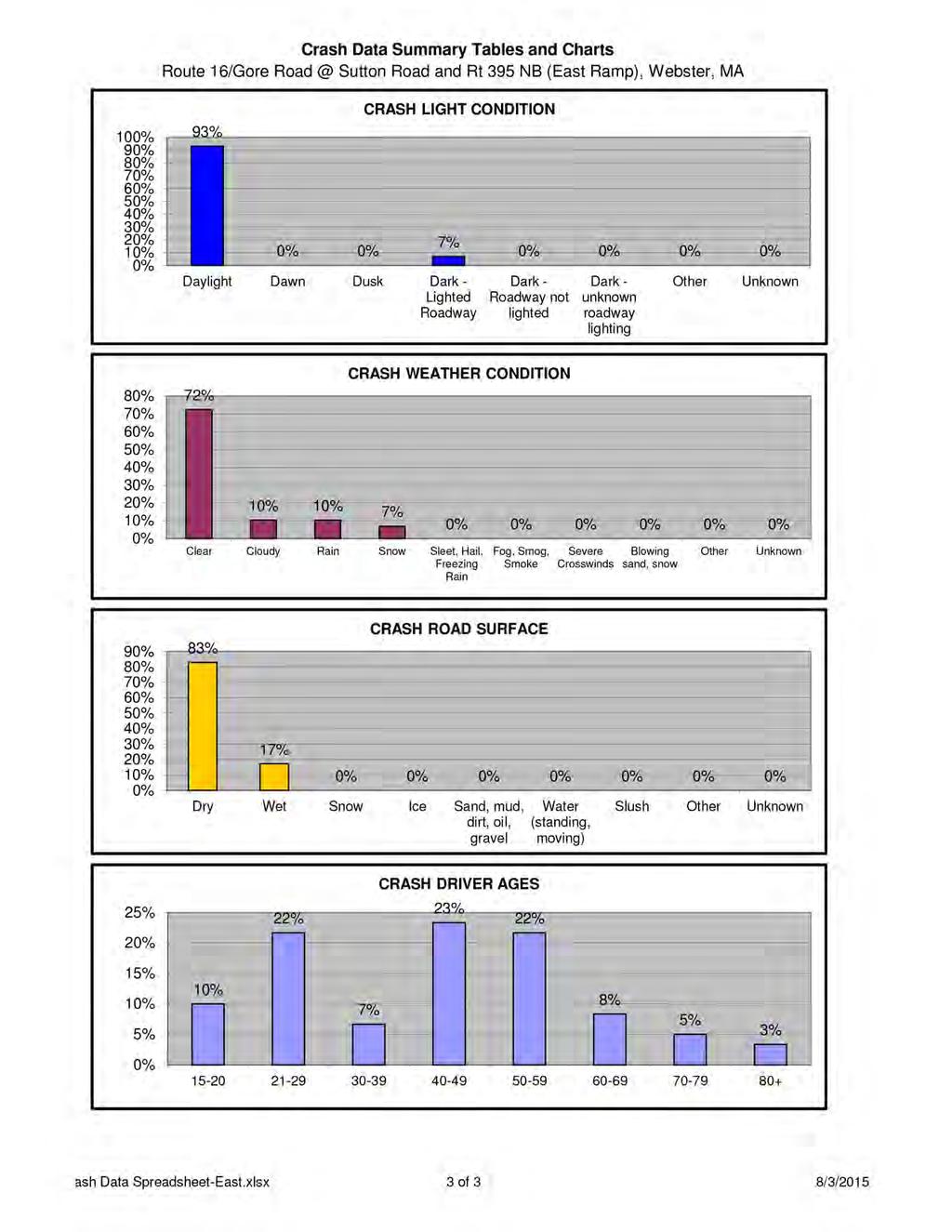
7 There were a total of 29 crashes reported at the intersection of Route 16 at Interstate 395 North and Sutton Road. Of the crashes that occurred, 14 (48%) were angled collisions. Additionally, there were eight rearend collisions, three sideswipe crashes, three head-on collision, and one unknown type of crash. Six of the eight rear-end collisions occurred at the northbound right movement with vehicles traveling from Interstate 395 North to Route 16 East. Of the 29 reported crashes, eight resulted in personal injury; no fatalities were reported at the intersection. 93% of the crashes occurred under daylight conditions with 24% of the collisions ocurring on both Wednesday and Thursday. Also, 28% of the crashes occurred between 4:00 PM and 6:00 PM. Detailed crash diagrams are provided in Appendix C. Road Safety Audit Observations and Potential Improvements During the RSA meeting, a brief introduction of the RSA process and a summary of the study area and crash information were presented to the audit participants. Following this brief presentation, the members of the audit team were asked to discuss the existing issues that may affect safety at the two intersections along Route 16. A site visit to both intersections was then conducted, followed by a discussion of potential enhancements and countermeasures addressing the issues discussed earlier. Provided below is a list of the safety concerns that were identified during the RSA along with potential enhancements that address these concerns. Route 16 at Interstate 395 South Safety Issue #1: Traffic Control Observations: Traffic is controlled at the Interstate 395 off-ramp southbound right approach by an existing stop sign on the right side of the roadway. During the RSA meeting, participants mentioned that due to the geometry of the roadway and the lack of advanced warning, drivers assume the approach is yield-controlled and do not come to the necessary stop before entering the intersection. It was noted that the existing stop sign is difficult to see from further up the ramp because it is obscured by vegetation and Existing stop sign at the southbound right approach obscured by vegetation and driver position. the horizontal geometry of the roadway. During the site visit, vehicles were observed traveling down the off-ramp at high speeds and a majority of drivers only stopped in order to yield to vehicles traveling along Route 16, despite the stop condition at the approach. This may be a primary factor in the 19 rear-end crashes at this intersection between 2011 and 2013 involving southbound right-turning vehicles. The crash data summary for the southbound right approach details that most of the accidents were a result of drivers misjudging the stopping actions of the vehicles in front of them, leading to rear-end collisions. Page 5

8 RSA participants also noted during the site visit that the pavement markings at the southbound left approach were obscured. It was discussed that the markings might be worn from vehicles, traveling at high speeds along the off-ramp, braking heavily at the stop approach. The audit team also discussed their concern with the placement of the yield sign located at the eastbound right turn onto the Interstate 395 South on-ramp. Currently, the yield sign is located at the entrance to the island and it was mentioned that the sign position creates confusion for eastbound vehicles turning right onto Interstate 395 South as to who has the right of way. There are also no existing pavement markings indicating the yield condition. Enhancements: Evaluate size and position of existing stop sign at the southbound right turn approach and add reflective strips to increase driver awareness of the upcoming stop Add stop sign to the left side of the southbound right turn approach to increase driver awareness of stop approach Add advance Stop Ahead signs to the southbound off-ramp to warn drivers of upcoming stop sign controls Evaluate changing the existing southbound right stop-controlled approach to yieldcontrolled to align with the way that drivers are currently operating within the intersection Relocate the existing yield sign at the right turn to the I-395 on-ramp closer to the intersection and add yield lines to warn drivers of the upcoming yield Safety Issue #2: Roadway Geometry Observations: During the RSA, it was discussed that there are several geometric issues at the intersection of Route 16 and the Interstate 395 South ramps. The first is the sloping angle of the southbound right approach. An RSA participant mentioned that the existing angular geometry might not meet the standards for a stop controlled approach and that it should be more perpendicular to increase driver awareness. Another repercussion of the southbound right turn geometry is that it may be difficult for older drivers to look left (to the east) and determine if there is a suitable gap for them to enter the intersection. The audit team also discussed the potential solar glare Wide angle of the southbound right approach. issue for southbound and westbound drivers in the weekday evening peak hours. After review of the crash data, it was shown that October had the highest number of crashes, and an audit participant noted that this could be a result of the solar glare during that time of year. Another topic discussed by the RSA team was the width of the Route 16 cross section. Presently, there is a bottleneck on Route 16, west of the intersection with the Interstate 395 South ramps at the Mill Brook culvert. The width of the roadway at this location is approximately 36 feet, which limits the capacity of the roadway because the lane capacity is restricted in this area. Pedestrian and bicycle facilities are also limited in this area due to the inability to expand the width of the roadway. Page 6

9 Enhancements: Evaluate geometric changes, such as creating a more perpendicular approach for the southbound right turn, to meet standards for a stop-controlled approach and to increase driver cognizance of an impending stop Evaluate existing roadway geometry to minimize solar glare and increase visibility for drivers turning onto Route 16 Evaluate widening alternatives to the roadway that address the bottleneck caused by the Mill Brook culvert, so there is increased capacity on the roadway for vehicles, cyclists, and pedestrians. Evaluate widening the roadway to install a merge area for southbound right turning vehicles heading westbound. A merge area could provide a safer yield condition at the approach and reduce the number of rear-end collisions. Safety Issue #3: Sight Distance Observations: The audit team noted several sight distance issues at the intersection. One issue that was brought up in the meeting was the existing sign clutter at the southbound Interstate 395 off-ramp approach, creating problems particularly for vehicles making a left-turn onto Route 16. When looking to the west, drivers views are blocked by the recently installed Wrong Way and Do Not Enter signs located on the island separating left and right turning vehicles. During the site visit, it was noted that several of the existing signs are not necessary given the current operations of the intersection. One participant noted that the One Way sign facing the wooded area to the west of the approach and the Do Not Block Intersection sign did not assist driver understanding of the intersection operations. Another sight distance issue brought up at the RSA was the vegetation located to the east and west of the southbound approach. It was mentioned that the existing vegetation blocks drivers looking eastbound and westbound, which could inhibit their ability to judge the appropriate gaps for their turning movements. It was also noted that the vegetation obstructs the stop sign on the southbound right approach, causing more confusion as to the required actions while approaching the intersection. Existing sign clutter looking west from the I-395 Southbound off-ramp. Other audit participants noted that southbound vehicles stopped to make left turns effectively obstruct sight distance for southbound right-turning vehicles looking left to determine when to proceed onto Route 16. Enhancements: Relocate existing signs upstream of the southbound ramp and remove unnecessary signage to improve visibility for drivers turning onto Route 16 Trim vegetation to the east and west of the intersection to improve driver sight distance Consider offsetting southbound left turns to increase sight distance for southbound right turning vehicles Page 7

10 Safety Issue #4: Pedestrian and Bicycle Accommodations Observations: Audit participants observed a lack of pedestrian and bicycle facilities at the intersection of Route 16 and Interstate 395 South as well as along the section of road between the I-395 North and South ramps. There are no crosswalks along any of the intersection approaches and no sidewalks approaching the intersection. A participant mentioned a walkway on the south side of Route 16 in the vicinity of the intersection; however, it was determined that this was intended to be used for maintenance purposes because of the narrow width and lack of connectivity to other pedestrian Worn shoulder indicating pedestrian travel along the north side of Route 16 between the I-395 Northbound and Southbound ramps. facilities. During the site walk, it was also observed that there was a worn shoulder to the north of Route 16 which indicates that pedestrians are using that area as a pathway and demonstrates that there is a demand for pedestrian accommodations in that area. The audit team hypothesized that pedestrians were using that path as a connection between the MAPFRE Insurance building to the east and the recently built Price Chopper grocery store, located to the west. During the RSA meeting, it was also discussed that the existing shoulder is not adequate for bicycle traffic along Route 16. The shoulder narrows in the vicinity of the intersection of Route 16 and the Interstate 395 South ramps because of the crossing at Mill Brook; cyclists traveling along this portion of roadway are forced into the travel lane with vehicles traveling at speeds of 30 miles per hour or higher. During the audit site walk, several bicyclists were noted traveling along Route 16. Enhancements: Widen Route 16 to increase the roadway cross section and provide space for pedestrian and cyclist accommodations Evaluate adding a sidewalk to the north side of Route 16 to meet the existing pedestrian demand Evaluate restriping the roadway to provide wider shoulders for cyclists Evaluate adding a separate bicycle and pedestrian bridge over the Mill Brook spillway to provide a facility for non-vehicular modes that does not require widening the roadway Page 8

11 Route 16 at Interstate 395 North and Sutton Road Safety Issue #1: Traffic Control Observations: The RSA team observed a number of issues regarding traffic control at the intersection of Route 16 at Interstate 395 North and Sutton Road. It was noted that at this intersection there were a large number of signs, particularly Wrong Way signs located at the I-395 off-ramp approach, which created confusion for drivers. One participant mentioned that while traveling to the onramp of Interstate 395 North, the Wrong Way signs were directed in such a way that vehicles were unsure of whether or not they Existing Keep Right Sign does not meet current sign specification standards. were traveling in the right direction, and that this misunderstanding could potentially cause crashes in the future. During the site visit, it was also pointed out that the Keep Right sign at the splitter island on the Sutton Road southbound approach does not meet current MassDOT standards and this could also lead to driver confusion. Another traffic control issue that was identified was the lack of speed regulation signs along the corridor of study. It was discussed that, in particular, cars traveling in the eastbound direction on Route 16 tended to speed up after passing through several signalized intersections to the west and this could be attributed to the fact that drivers are not aware of the approaching Interstate 395 intersections. It was noted that the high speeds along Route 16 could have been a factor in the five angle and head-on injury crashes at the intersection, especially in cases where the eastbound traffic was in conflict with northbound through and westbound left-turning vehicles. During the RSA meeting, the team noted two courtesy crashes that occurred at the intersection as a result of a non-involved mainline driver granting the right of way, contrary to the rules of the road, to another driver. It was identified that a potential cause of these courtesy crashes was the offset of the left turn lanes. A participant mentioned that turning vehicles on both directions of Route 16 are not currently positioned in a way so that they are able to see the through traffic around the queue of opposing left-turning vehicles, which could be an explanation for the number of crashes at that location. Another traffic control issue identified by the RSA participants was the lack of pavement marking separation between the right turning vehicles and those traveling left or through the intersection at the southbound Sutton Road approach. Presently, the approach effectively operates as two separate lanes, but confusion arises when large commercial vehicles originating from land uses to the north of Sutton Road use the entire approach width to make a left turn onto Route 16 eastbound. A comment received in response to the draft report stated that the southbound Sutton Road has also operated as three lanes in certain circumstances at the intersection. The employees of MAPFRE Insurance noted that an informational Interstate 395 sign to the east of the MAPFRE Insurance driveway has been directing vehicles into the MAPFRE driveway that are looking for access to Interstate 395. Page 9

12 Enhancements: Evaluate size and position of existing signs and replace signs with updated alternatives to alleviate driver confusion at the intersection Evaluate installation of speed advisory signs to warn motorists of upcoming dangerous intersections Consider a long term speed study to establish a permanent speed limit along Route 16 in the vicinity of the project area Restripe the exclusive left turn lanes on Route 16 so that there is a buffer between the left turning and through vehicles to increase sight distance for left-turning vehicles and minimize the number of courtesy crashes within the intersection Evaluate restriping the Sutton Road southbound approach to add additional lanes and clarify movements at the approach Relocate I-395 informational sign to the west of the MAPFRE driveway to minimize driver confusion Safety Issue #2: Roadway Geometry Observations: During the RSA meeting, there were multiple issues relating to the existing geometry of the roadway discussed. One of the major concerns at the intersection of Sutton Road and Interstate 395 North at Route 16 was the congestion within the intersection. Given the existing geometry of the roadway, it was stated that heavy traffic along Route 16 caused queueing on Sutton Road and the Interstate 395 offramp because of the difficultly for vehicles to find the appropriate gap for a turning maneuver. After examination of the crash data, it was shown that a majority of crashes occurred during the afternoon peak hour when the congestion is likely highest at this intersection. Eastbound left turning vehicles block southbound left turning vehicles traveling from Sutton Road. The audit team also discussed the geometry of the existing left-through northbound movement from the Interstate 395 North off-ramp. While drivers are able to travel to both the north and west, the existing lane is curved to the west. It was determined that this could confuse drivers into thinking that the through movement onto Sutton Road is prohibited and also limits the visibility of drivers looking right (to the east) who are trying to determine if there is an adequate gap between westbound through moving vehicles. Another discussion during the RSA meeting was that vehicles traveling from Interstate 395 North typically have to stop while turning right onto Route 16, despite the yield condition of the approach, due to the lack of an acceleration lane and the tight radius of the channelized right turn. Page 10
13 RSA participants also identified that the existing roadway geometry creates a potential solar glare issue for vehicles turning right from the northbound off ramp. It was noted that during the afternoon commuter travel, right-turning drivers might have difficulty seeing the traffic traveling along Route 16 eastbound. Enhancements: Evaluate adding a traffic signal or roundabout to the intersection (and potentially at the I- 395 Southbound ramps intersection as well) to reduce congestion and control gaps for turning vehicles Evaluate tightening the radius or modifying the geometry of the northbound right turn to reduce solar glare for vehicles turning from the I-395 Northbound off-ramp Evaluate widening of the northbound left/through lane to improve the intersection offset for through moving vehicles onto Sutton Road. Consider sight distance with the addition of another lane Evaluate modifying the roadway geometry so that vehicles turning left from the eastbound approach do not block vehicles turning left from the southbound Sutton Road approach Evaluate adding an acceleration lane for the Interstate 395 North channelized right turn Safety Issue #3: Traffic Operations Observations: The RSA team observed a number of issues regarding traffic operations. During the meeting it was stated that there is no existing transit service within the RSA study area. A MAPFRE employee stated that he did not know the number of employees traveling from the Worcester area, but said that it is possible that a number of the employees traveling by car from that area could benefit from an expansion of the Worcester Regional Transit Authority (WRTA) to the Webster area. A representative from the Central Massachusetts Regional Planning Commission researched the existing transit routes and determined that WRTA Bus Route #42 to downtown Webster operates along Route 12, approximately 0.5 miles from the MAPFRE property, and could possibly be extended to loop through the property. It was communicated that the extension of Bus Route #42 complies with the WRTA service standards of providing service to major employment areas. Another issue that the RSA team identified was that vehicles traveling on Route 16 in the eastbound direction were speeding through the intersection with the Interstate 395 North ramps and Sutton Road after passing through the signalized intersection to the west. The audit members noted that the higher speeds along the Route 16 corridor would create difficulty for vehicles trying to turn onto Route 16 from Sutton Road or Interstate 395 North. Another participant noted that the speeds of vehicles traveling along Route 16 make it difficult for vehicles turning eastbound from the Interstate 395 off-ramp to judge appropriate entrance gaps into the intersection. The inability to judge gaps in conjunction with the sharp angle geometry and sign clutter at the off-ramp approach could be contributing factors in the six rear-end collisions at that location. The Webster Chief of Police did not recall any speed enforcement that had been set up at this section of the roadway. During the meeting, it was also identified that there was an industrial land use to the north of the MAPFRE Insurance building on Sutton Road. Participants noted that heavy vehicles from the industrial park travel southbound on Sutton Road to the intersection with Route 16 and turn left at the intersection. This heavy vehicle traffic contributes to the queueing of the southbound left traffic because the trucks need a longer gap to turn onto Route 16. As a result of the queueing on Sutton Road, MAPFRE Insurance security stated that vehicles travelling south on Sutton Road often cut-through the MAPFRE parking lot in order to avoid traveling through the intersection with Interstate 395 North and Route 16. They stated that in the past, this Page 11

14 has caused several crashes within the MAPFRE parking lot due to the high speeds of the vehicles traveling through the site. Also adding to the congestion within the intersection and the queueing in at the southbound approach, it was noted that eastbound vehicles making a left turn onto Sutton Road wait in the middle of the intersection to make this turn, blocking southbound left turning vehicles in the process. A MAPFRE Insurance employee identified the southbound left movement as being heavily used by employees after work hours; when those turning vehicles are blocked from making this movement, thus lengthening the queue along Sutton Road. Enhancements: Evaluate future regional transit service expansion on Route 16 or Sutton Road to reduce the number of passenger vehicles utilizing the intersection Consider speed trailers and additional enforcement to reduce speeding through the intersection, in particular for the eastbound through and southbound right approaches Consider adding signage on Sutton Road and increase driver education to encourage drivers traveling southbound from the commercial buildings on Sutton Road to seek an alternate route Evaluate signs and traffic calming measures within the MAPFRE Insurance parking lot to reduce vehicles using it as a cut-through to Route 16 eastbound Safety Issue #4: Sight Distance Observations: The RSA team discussed several issues regarding sight distance at the intersection of Route 16 at Interstate 395 and Sutton Road. Vegetation to the west of the intersection diminishes the sight distance of vehicles traveling southbound on Sutton Road. In particular, it was identified that vehicles traveling through or turning left from Sutton Road were unable to see vehicles traveling eastbound on Route 16. It was also mentioned that the sight distance of the southbound right turning vehicles is obstructed by left turning or through-moving vehicles due to the treatment of Sutton Road as two separate lanes. Existing vegetation reduces the sight distance for southbound vehicles on Sutton Road. Another issue at this location was the amount of signage that blocked the sight distance of turning vehicles. Similar to the intersection at the Interstate 395 South ramps, the number and position of informational and warning signs impairs sight distance for vehicles turning onto Route 16 from the northbound and southbound directions. In particular, the sign clutter at the Interstate 395 North off-ramp could be a contributing factor to the six rear-end collisions that occurred involving vehicles turning eastbound at that approach. Page 12
15 Enhancements: Trim vegetation to the west of the intersection to increase sight distance Relocate existing signs further from Route 16 and remove unnecessary signage to improve visibility for drivers turning onto Route 16 Safety Issue #5: Pedestrian and Bicycle Accommodations Observations: Similar to the discussion of the intersection of Route 16 and Interstate 395 South, the RSA team determined that the intersection of Route 16 at Interstate 395 North and Sutton Road does not currently have adequate accommodations for pedestrians and bicycles. There is an existing sidewalk on the northeastern approach to the intersection; however, there are no facilities that connect that sidewalk to other parts of the intersection. There is also a wide shoulder north of Route 16 and east of Sutton Road for bicycle use, but that shoulder narrows as cyclists travel west towards the Price Chopper grocery store and other retail land uses. Enhancements: Widen Route 16 to increase the roadway cross section and provide space for pedestrian and cyclist accommodations Evaluate adding a sidewalk to the north side of Route 16 to meet the existing pedestrian demand Evaluate restriping the roadway to provide wider shoulders for cyclists Recommendations After discussing the various safety deficiencies within the study area, participants discussed potential solutions. The audit participants were encouraged to consider both short and long-term improvements for each of the existing safety issues. Each improvement considered has been categorized as short-term, midterm, or long-term based on the definitions shown in Table 2. Additionally, a cost category has been assigned to each improvement based on the parameters set forth in Table 2. Table 2. Estimated Time Frame and Costs Breakdown Time Frame Costs Short-Term <1 Year Low <$10,000 Mid-Term 1-3 Years Medium $10,001-$50,000 Long-Term >3 Years High >$50,000 Summary of Road Safety Audit A summary of the potential recommendations discussed by the RSA audit team are summarized in Table 3. The recommendations are summarized based on the potential safety payoff, time frame, approximate cost and responsible agency. The safety payoff is a subjective judgment of the potential effectiveness of the safety recommendations listed below. Page 13
16 Table 3. Potential Safety Enhancement Summary Safety Safety Issue Potential Safety Enhancement Time Frame Cost Payoff Responsible Agency Route 16 at Interstate 395 South Evaluate size and position of existing stop sign Traffic Control at the southbound right turn approach and add reflective strips to increase driver awareness of Medium Short-Term Low MassDOT the upcoming stop Add stop sign to the left side of the southbound Traffic Control right turn approach to increase driver Medium Short-Term Low MassDOT awareness of stop approach Add advance Stop Ahead signs to the Traffic Control southbound off-ramp to warn drivers of Medium Short-Term Low MassDOT Traffic Control upcoming stop sign controls Evaluate changing the existing southbound right stop-controlled approach to yield-controlled to align with the way that drivers are currently Low Mid-Term Low MassDOT Traffic Control operating within the intersection Relocate the existing yield sign at the right turn to the I-395 on-ramp closer to the intersection and add yield lines to warn drivers of the Medium Short-Term Low MassDOT upcoming yield Evaluate geometric changes, such as creating a more perpendicular approach for the Roadway Geometry southbound right turn, to meet standards for a High Long-Term High MassDOT stop-controlled approach and to increase driver cognizance of an impending stop Evaluate existing roadway geometry to minimize Roadway Geometry solar glare and increase visibility for drivers Low Long-Term High MassDOT turning onto Route 16
17 Safety Issue Potential Safety Enhancement Safety Responsible Time Frame Cost Payoff Agency Evaluate widening alternatives to the roadway Roadway Geometry that address the bottleneck caused by Mill Brook so there is increased capacity on the High Long-Term High MassDOT Roadway Geometry roadway for vehicles, cyclists, and pedestrians Evaluate widening the roadway to install a merge area for southbound right turning vehicles heading westbound. A merge area could provide a safer yield condition at the High Long-Term High MassDOT Sight Distance approach and reduce the number of rear-end collisions Relocate existing signs upstream of the southbound ramp and remove unnecessary signage to improve visibility for drivers turning High Short-Term Low MassDOT Sight Distance onto Route 16 Trim vegetation to the east and west of the intersection to improve driver sight distance High Short-Term Low MassDOT Consider offsetting southbound left turns to Sight Distance increase sight distance for southbound right Medium Mid-Term Medium MassDOT turning vehicles Widen Route 16 to increase the roadway cross Pedestrian and Bicycle section and provide space for pedestrian and Accommodations cyclist accommodations Medium Long-Term High MassDOT Evaluate adding a sidewalk to the north side of Pedestrian and Bicycle Route 16 to meet the existing pedestrian Accommodations demand High Long-Term High MassDOT Pedestrian and Bicycle Evaluate restriping the roadway to provide wider Accommodations shoulders for cyclists High Short-Term Low MassDOT Evaluate adding a separate bicycle and Pedestrian and Bicycle pedestrian bridge over the Mill Brook spillway to Accommodations provide a facility for non-vehicular modes that High Long-Term High MassDOT does not require widening the roadway
18 Safety Issue Potential Safety Enhancement Safety Responsible Time Frame Cost Payoff Agency Route 16 at Interstate 395 North and Sutton Road Evaluate size and position of existing signs and Traffic Control replace signs with updated alternatives to Medium Short-Term Low MassDOT alleviate driver confusion at the intersection Evaluate installation of speed advisory signs to Traffic Control warn motorists of upcoming dangerous Low Short-Term Low MassDOT intersections Consider a long term speed study to establish a Traffic Control permanent speed limit along Route 16 in the Medium Long-Term High MassDOT Traffic Control vicinity of the project area Restripe the exclusive left turn lanes on Route 16 so that there is a buffer between the left turning and through vehicles to increase sight distance for left turning vehicles and minimize High Short-Term Low MassDOT the number of courtesy crashes within the intersection Evaluate restriping the Sutton Road southbound Traffic Control approach to add additional lanes and clarify Medium Short-Term Low MassDOT movements at the approach Relocate I-395 informational sign to the west of Traffic Control the MAPFRE driveway to minimize driver Low Short-Term Low MassDOT Roadway Geometry confusion Evaluate adding a traffic signal or roundabout to the intersection (and potentially at the I-395 Southbound ramps intersection) to reduce High Long-Term High MassDOT Roadway Geometry congestion and control gaps for turning vehicles Evaluate tightening the radius or modifying the geometry of the northbound right turn to reduce solar glare for vehicles turning from the I-395 Northbound off-ramp High Long-Term High MassDOT
19 Safety Issue Potential Safety Enhancement Safety Responsible Time Frame Cost Payoff Agency Evaluate widening of the northbound left/through lane to improve the intersection Roadway Geometry offset for through moving vehicles onto Sutton Medium Long-Term High MassDOT Roadway Geometry Road. Consider sight distance with the addition of another lane Evaluate modifying the roadway geometry so that vehicles turning left from the eastbound approach do not block vehicles turning left from Medium Long-Term High MassDOT Roadway Geometry the southbound Sutton Road approach Evaluate adding an acceleration lane for the Interstate 395 North channelized right turn High Long-Term High MassDOT Evaluate future regional transit service WRTA/CMRPC/ Traffic Operations expansion on Route 16 or Sutton Road to Town of Low Mid-Term Medium reduce the number of passenger vehicles Webster/ utilizing the intersection MAPFRE Traffic Operations Consider speed trailers and additional enforcement to reduce speeding through the intersection, in particular for the eastbound Medium Short-Term Medium Town of Webster through and southbound right approaches Consider adding signage on Sutton Road and increase driver education to encourage drivers Traffic Operations traveling southbound from the commercial Low Short-Term Low Town of Webster Traffic Operations buildings on Sutton Road to seek an alternate route Evaluate signs and traffic calming measures within the MAPFRE Insurance parking lot to reduce vehicles using it as a cut-through to Medium Short-Term Low MAPFRE Sight Distance Route 16 eastbound Trim vegetation to the west of the intersection to increase sight distance High Short-Term Low MassDOT Relocate existing signs further from Route 16 Sight Distance and remove unnecessary signage to improve Medium Short-Term Low MassDOT visibility for drivers turning onto Route 16
20 Safety Issue Potential Safety Enhancement Safety Responsible Time Frame Cost Payoff Agency Widen Route 16 to increase the roadway cross Pedestrian and Bicycle section and provide space for pedestrian and Accommodations cyclist accommodations Medium Long-Term High MassDOT Evaluate adding a sidewalk to the north side of Pedestrian and Bicycle Route 16 to meet the existing pedestrian Accommodations demand High Long-Term High MassDOT Pedestrian and Bicycle Evaluate restriping the roadway to provide wider Accommodations shoulders for cyclists High Short-Term Low MassDOT
21 Appendix A. RSA Meeting Agenda
22
23 Appendix B. RSA Audit Team Contact List
24 Audit Team Members William Ullom John Mastera Participating Audit Team Members Date: September 2, 2015 Location: MAPFRE Insurance, Webster, MA Agency/ Affiliation MassDOT Traffic Operations MassDOT Highway Safety Address Phone Number Rebecca Hansen McMahon Associates Phil Viveiros McMahon Associates Joe Frawley MassDOT District 3 joseph.frawley@dot.state.ma.us Scott D. Charpentier Town of Webster scharpentier@webster-ma.gov x 1028 Mark Giro MAPFRE Insurance mgiro@mapfreusa.com Derrick Provencher MAPFRE Insurance DProvencher@mapfreusa.com Peter Gagliardo MAPFRE Insurance PGagliardo@mapfreusa.com Tom Zona MA State Police Thomas.zona@pol.state.ma.us Dan Daniska Yahaira Graxirena Promise Otaluka Kenny Pizzetti Central Massachusetts Regional Planning Commission Central Massachusetts Regional Planning Commission Federal Highway Administration Webster Highway Department ddaniska@cmrpc.org ygraxirena@cmrpc.org promise.otaluka@dot.gov kpizzetti@webster.gov Timothy Bent Webster Police bentt@websterpolice.com Robert Blackmer MAPFRE Insurance rblackmer@mapfreusa.com William Prout MAPFRE Insurance wprout@mapfreusa.com
25 Appendix C. Detailed Crash Data
26
27
28
29
30
31
32
33
ROAD SAFETY AUDIT. State Road (Route 6) Corridor Town of Dartmouth. March Prepared For: MassDOT
 Corridor Town of Dartmouth. March Prepared For: MassDOT") ROAD SAFETY AUDIT State Road (Route 6) Corridor Town of Dartmouth March 2015 Prepared For: MassDOT Prepared By: McMahon Associates, Inc. 300 Myles Standish Blvd. Suite 201 Taunton, MA 02780 Table of Contents
ROAD SAFETY AUDIT State Road (Route 6) Corridor Town of Dartmouth March 2015 Prepared For: MassDOT Prepared By: McMahon Associates, Inc. 300 Myles Standish Blvd. Suite 201 Taunton, MA 02780 Table of Contents
ROAD SAFETY AUDIT. Route 114 at Interstate I-495 Northbound Ramps. City of Lawrence. July 30, 2015
 ROAD SAFETY AUDIT Route 114 at Interstate I-495 Northbound Ramps City of Lawrence July 30, 2015 Prepared For: Massachusetts Department of Transportation Prepared By: Toole Design Group 33 Broad Street,
ROAD SAFETY AUDIT. Route 135 at Route 30 Town of Westborough. January Prepared For: MassDOT
 ROAD SAFETY AUDIT Route 135 at Route 30 January 2016 Prepared For: MassDOT Prepared By: McMahon Associates, Inc. 300 Myles Standish Blvd. Suite 201 Taunton, MA 02780 Road Safety Audit Route 135 at Route
ROAD SAFETY AUDIT. Route 202 (East State Street)/School Street & Route 202 (West State Street)/Pleasant Street/Amherst Street Town of Granby
/School Street & Route 202 (West State Street)/Pleasant Street/Amherst Street Town of Granby") ROAD SAFETY AUDIT Route 202 (East State Street)/School Street & Route 202 (West State Street)/Pleasant Street/Amherst Street Town of Granby March 2013 Prepared for: Massachusetts Department of Transportation
ROAD SAFETY AUDIT Route 202 (East State Street)/School Street & Route 202 (West State Street)/Pleasant Street/Amherst Street Town of Granby March 2013 Prepared for: Massachusetts Department of Transportation
Route 28 (South Orleans Road)/Route 39 (Harwich Road)/Quanset Road Intersection
/Route 39 (Harwich Road)/Quanset Road Intersection") TRAFFIC FEASIBILITY STUDY Route 28 (South Orleans Road)/Route 39 (Harwich Road)/Quanset Road Intersection Orleans, Massachusetts Prepared for: Town of Orleans Prepared by: Fay, Spofford & Thorndike, LLC
TRAFFIC FEASIBILITY STUDY Route 28 (South Orleans Road)/Route 39 (Harwich Road)/Quanset Road Intersection Orleans, Massachusetts Prepared for: Town of Orleans Prepared by: Fay, Spofford & Thorndike, LLC
ROAD SAFETY AUDIT. Granite Avenue at Interstate 93 Ramps. Town of Milton. May 22, Prepared for: MassDOT
 ROAD SAFETY AUDIT Granite Avenue at Interstate 93 Ramps Town of Milton May 22, 2017 Prepared for: MassDOT Prepared by: Toole Design Group 2 Oliver Street, Suite 305 Boston, MA 02109 Table of Contents Background...
ROAD SAFETY AUDIT. County Street at Hart Street. City of Taunton. January 30, Prepared For: Massachusetts Department of Transportation
 ROAD SAFETY AUDIT County Street at Hart Street City of Taunton January 30, 2015 Prepared For: Massachusetts Department of Transportation Prepared By: Toole Design Group 33 Broad Street, 4 th Floor Boston,
ROAD SAFETY AUDIT. Centre Street (Route 123) at Plymouth Street. Municipality of Brockton. November, Prepared For: MassDOT
 at Plymouth Street. Municipality of Brockton. November, Prepared For: MassDOT") ROAD SAFETY AUDIT Centre Street (Route 123) at Plymouth Street Municipality of Brockton November, 2017 Prepared For: MassDOT On Behalf Of: City of Brockton Prepared By: Old Colony Planning Council 70 School
ROAD SAFETY AUDIT Centre Street (Route 123) at Plymouth Street Municipality of Brockton November, 2017 Prepared For: MassDOT On Behalf Of: City of Brockton Prepared By: Old Colony Planning Council 70 School
ROAD SAFETY AUDIT. East Main Street (Route 123) at Route I-495 Northbound & Southbound Ramps Town of Norton. May 11, Prepared For: MassDOT
 at Route I-495 Northbound & Southbound Ramps Town of Norton. May 11, Prepared For: MassDOT") ROAD SAFETY AUDIT East Main Street (Route 123) at Route I-495 Northbound & Southbound Ramps Town of Norton May 11, 2016 Prepared For: MassDOT Prepared By: 101 Walnut Street Watertown, MA Road Safety Audit
ROAD SAFETY AUDIT East Main Street (Route 123) at Route I-495 Northbound & Southbound Ramps Town of Norton May 11, 2016 Prepared For: MassDOT Prepared By: 101 Walnut Street Watertown, MA Road Safety Audit
ROAD SAFETY AUDIT. Russell Street (Route 9) at North and South Maple Streets Town of Hadley. March 2014
 at North and South Maple Streets Town of Hadley. March 2014") ROAD SAFETY AUDIT Russell Street (Route 9) at North and South Maple Streets Town of Hadley March 2014 Prepared for: Massachusetts Department of Transportation Prepared by: Howard/Stein-Hudson Associates
ROAD SAFETY AUDIT Russell Street (Route 9) at North and South Maple Streets Town of Hadley March 2014 Prepared for: Massachusetts Department of Transportation Prepared by: Howard/Stein-Hudson Associates
ROAD SAFETY AUDIT. Providence Street (Route 122A) at McKeon Road/Millbury Street. City of Worcester. July 14, Prepared For: MassDOT
 at McKeon Road/Millbury Street. City of Worcester. July 14, Prepared For: MassDOT") ROAD SAFETY AUDIT Providence Street (Route 122A) at McKeon Road/Millbury Street City of Worcester July 14, 2016 Prepared For: MassDOT Prepared By: Stantec Consulting Services, Inc. Burlington, Massachusetts
ROAD SAFETY AUDIT Providence Street (Route 122A) at McKeon Road/Millbury Street City of Worcester July 14, 2016 Prepared For: MassDOT Prepared By: Stantec Consulting Services, Inc. Burlington, Massachusetts
ROAD SAFETY AUDIT. May 18, Prepared For: MassDOT. On Behalf Of: Town of Milford
 ROAD SAFETY AUDIT East Main Street (Route 16) at Medway Road (Route 109), East Main Street (Route 16) at Quarry Square Driveways, East Main Street (Route 16) at Beaver Street/ Fortune Boulevard Town of
Appendix C. TRAFFIC CALMING PROGRAM TOOLBOX
 Appendix C. TRAFFIC CALMING PROGRAM TOOLBOX PHASE I...2 Do Not Enter Sign...3 One-Way Sign...4 Turn Prohibition...5 Pavement Markings...6 Speed Monitoring Trailer...7 Neighborhood Speed Watch...8 Police
Draft North Industrial Area-Wide Traffic Plan
 Summary of North Industrial and Hudson Bay Industrial Recommended Improvements Table 1. Summary of s Item Location 1 2 3 4 5 6 7 8 9 10 11 12 Millar Ave north of 51st St Super 8 Motel back lane 400 Block
Guidance. ATTACHMENT F: Draft Additional Pages for Bicycle Facility Design Toolkit Separated Bike Lanes: Two-Way to One-Way Transitions
 ATTACHMENT F: Draft Additional Pages for Bicycle Facility Design Toolkit Separated Bike Lanes: Two-Way to One-Way Transitions This treatment provides a transition from two-way separated bike lanes to one-way
AGENDA ITEM 6 D THOMASVILLE ROAD (HERMITAGE BOULEVARD TO LIVE OAK PLANTATION ROAD) ROADWAY SAFETY AUDIT
 ROADWAY SAFETY AUDIT") May 15, 2018 AGENDA ITEM 6 D THOMASVILLE ROAD (HERMITAGE BOULEVARD TO LIVE OAK PLANTATION ROAD) ROADWAY SAFETY AUDIT TYPE OF ITEM: Discussion STATEMENT OF ISSUE The Florida Department of Transportation
May 15, 2018 AGENDA ITEM 6 D THOMASVILLE ROAD (HERMITAGE BOULEVARD TO LIVE OAK PLANTATION ROAD) ROADWAY SAFETY AUDIT TYPE OF ITEM: Discussion STATEMENT OF ISSUE The Florida Department of Transportation
ROAD SAFETY AUDIT. West Central Street (Route 140) at Franklin Village Drive. Town of Franklin. February 03, 2016
 at Franklin Village Drive. Town of Franklin. February 03, 2016") ROAD SAFETY AUDIT West Central Street (Route 140) at Franklin Village Drive Town of Franklin February 03, 2016 Prepared for: Massachusetts Department of Transportation Prepared by: Howard Stein Hudson
ROAD SAFETY AUDIT West Central Street (Route 140) at Franklin Village Drive Town of Franklin February 03, 2016 Prepared for: Massachusetts Department of Transportation Prepared by: Howard Stein Hudson
ROAD SAFETY AUDIT MDM. Columbia Road at Dorchester Avenue. Dorchester, MA 10/14/2016. Prepared For: MassDOT. On Behalf Of: Edens
 ROAD SAFETY AUDIT Columbia Road at Dorchester Avenue Dorchester, MA 10/14/2016 Prepared For: MassDOT On Behalf Of: Edens Prepared By: MDM Transportation Consultants, Inc. 28 Lord Road Suite 280 Marlborough,
Bay to Bay Boulevard Complete Streets Project
 Bay to Bay Boulevard Complete Streets Project Dale Mabry Highway to Bayshore Boulevard February 08, 2018 Photo Source: Tampa Bay Times Alessandra Da Pra Meeting Format Introduction Resurfacing Information
ROAD SAFETY AUDIT. Blue Hill Avenue (Route 28) and Warren Street High Crash Locations City of Boston. November 1, 2016
 and Warren Street High Crash Locations City of Boston. November 1, 2016") ROAD SAFETY AUDIT Blue Hill Avenue (Route 28) and Warren Street High Crash Locations City of Boston November 1, 2016 Prepared For: MassDOT Highway Division Prepared By: BETA Group, Inc. Table of Contents
ROAD SAFETY AUDIT Blue Hill Avenue (Route 28) and Warren Street High Crash Locations City of Boston November 1, 2016 Prepared For: MassDOT Highway Division Prepared By: BETA Group, Inc. Table of Contents
ROAD SAFETY AUDIT. Route 53 (Washington Street) High Crash Locations at Route 139 (Schoosett Street) and Route 14 (Congress Street) Town of Pembroke
 High Crash Locations at Route 139 (Schoosett Street) and Route 14 (Congress Street) Town of Pembroke") ROAD SAFETY AUDIT Route 53 (Washington Street) High Crash Locations at Route 139 (Schoosett Street) and Route 14 (Congress Street) Town of Pembroke April 29, 2016 Prepared For: MassDOT Highway Division
ROAD SAFETY AUDIT Route 53 (Washington Street) High Crash Locations at Route 139 (Schoosett Street) and Route 14 (Congress Street) Town of Pembroke April 29, 2016 Prepared For: MassDOT Highway Division
ROAD SAFETY AUDIT. Route 38 from Route 62 to Woburn Town Line. Town of Wilmington. April 10, Prepared For: MassDOT
 ROAD SAFETY AUDIT Route 38 from Route 62 to Woburn Town Line Town of Wilmington April 10, 2017 Prepared For: MassDOT Prepared By: Green International Affiliates, Inc. 239 Littleton Road, Suite 3, Westford,
FLORIDA DEPARTMENT OF TRANSPORTATION DISTRICT 7 DISTRICT WIDE BICYCLE/PEDESTRIAN ACCESS TO TRANSIT SAFETY ASSESSMENT AND IMPROVEMENT PLAN
 FLORIDA DEPARTMENT OF TRANSPORTATION DISTRICT 7 DISTRICT WIDE BICYCLE/PEDESTRIAN ACCESS TO TRANSIT SAFETY ASSESSMENT AND IMPROVEMENT PLAN TRANSIT SAFETY ASSESSMENT SR 55/US 19 AT 80 TH AVE N DRAFT JUNE
Appendix T CCMP TRAIL TRAFFIC & TRANSPORTATION DESIGN STANDARD
 Appendix T CCMP 3.3.4 TRAIL TRAFFIC & TRANSPORTATION DESIGN STANDARD 3.3.4 Trail Traffic and Transportation Design Multi-use trails have certain design standards, which vary depending on the agency that
ROAD SAFETY AUDIT. Mass Pike Interchange 6, I-291 and Burnett Road. City of Chicopee. November 4, Prepared For: MassDOT Highway Division
 ROAD SAFETY AUDIT Mass Pike Interchange 6, I-291 and Burnett Road City of Chicopee November 4, 2013 Prepared For: MassDOT Highway Division Prepared By: BETA Group, Inc. Table of Contents Project Data...
Ottawa Beach Road Study
 Ottawa Beach Road Study Prepared For: Park Township September 30, 2014 Project No. G140303 OTTAWA BEACH ROAD STUDY PREPARED FOR: PARK TOWNSHIP SEPTEMBER 30, 2014 PROJECT NO. G140303 TABLE OF CONTENTS 1.0
ROAD SAFETY AUDIT. Rourke Bridge at Pawtucket Boulevard (Route 113) City of Lowell. October 5, Prepared For: MassDOT.
 City of Lowell. October 5, Prepared For: MassDOT.") ROAD SAFETY AUDIT Rourke Bridge at Pawtucket Boulevard (Route 113) City of Lowell October, 2017 Prepared For: MassDOT Prepared By: Vanasse Hangen Brustlin, Inc 101 Walnut Street Watertown, MA 02472 Road
ROAD SAFETY AUDIT Rourke Bridge at Pawtucket Boulevard (Route 113) City of Lowell October, 2017 Prepared For: MassDOT Prepared By: Vanasse Hangen Brustlin, Inc 101 Walnut Street Watertown, MA 02472 Road
ROAD SAFETY AUDIT. Santilli Circle and Sweetser Circle. Municipality of Everett. March 10, Prepared For: MassDOT
 ROAD SAFETY AUDIT Santilli Circle and Sweetser Circle Municipality of Everett Prepared For: MassDOT On Behalf Of: WYNN Design and Development Prepared By: AECOM 250 Apollo Drive Chelmsford, MA Road Safety
ROAD SAFETY AUDIT. Route 2/Route 68 Interchange Rotary City of Gardner. August 3, Prepared For: MassDOT
 ROAD SAFETY AUDIT Route 2/Route 68 Interchange Rotary City of Gardner August 3, 2016 Prepared For: MassDOT Prepared By: Tetra Tech 100 Nickerson Avenue Marlborough, MA 01752 Road Safety Audit Route 2/Route
ROAD SAFETY AUDIT. Route 113 (Storey Avenue) at Woodman Way and Low Street. Newburyport, MA. May 27, Prepared For: MassDOT
 at Woodman Way and Low Street. Newburyport, MA. May 27, Prepared For: MassDOT") ROAD SAFETY AUDIT Route 113 (Storey Avenue) at Woodman Way and Low Street Newburyport, MA May 27, 2015 Prepared For: MassDOT Prepared By: Bayside Engineering, Inc. 600 Unicorn Park Drive Woburn, MA 01801
ROAD SAFETY AUDIT Route 113 (Storey Avenue) at Woodman Way and Low Street Newburyport, MA May 27, 2015 Prepared For: MassDOT Prepared By: Bayside Engineering, Inc. 600 Unicorn Park Drive Woburn, MA 01801
Date: April 4, Project #: Re: A Street/Binford Street Traffic/Intersection Assessment
 To: Peter Cavanaugh General Electric From: David Bohn, PE Ryan White, PE Date: April 4, 217 Project #: 13421. Re: / Traffic/Intersection Assessment Consistent with the Cooperation Agreement between the
TRAFFIC ACTION PLAN. Laurie Meadows Neighborhood CITY OF SAN MATEO
 TRAFFIC ACTION PLAN Laurie Meadows Neighborhood CITY OF SAN MATEO Draft January 2017 Table of Contents Introduction... 2 The Traffic Forum Process... 5 Neighborhood Traffic Issues... 7 Neighborhood Recommendations
TRAFFIC IMPACT ANALYSIS
 TRAFFIC IMPACT ANALYSIS FOR THE CHAMPAIGN UNIT#4 SCHOOL DISTRICT PROPOSED HIGH SCHOOL (SPALDING PARK SITE) IN THE CITY OF CHAMPAIGN Final Report Champaign Urbana Urbanized Area Transportation Study 6/24/2014
Off-road Trails. Guidance
 Off-road Trails Off-road trails are shared use paths located on an independent alignment that provide two-way travel for people walking, bicycling, and other non-motorized users. Trails specifically along
DEPARTMENT OF ENVIRONMENTAL SERVICES. North Harrison Street (Lee Highway to Little Falls Road) Comparative Analysis. Prepared for:
 Comparative Analysis. Prepared for:") DEPARTMENT OF ENVIRONMENTAL SERVICES North Harrison Street (Lee Highway to Little Falls Road) Comparative Analysis Prepared for: Arlington County Department of Environmental Services 2100 Clarendon Boulevard,
DEPARTMENT OF ENVIRONMENTAL SERVICES North Harrison Street (Lee Highway to Little Falls Road) Comparative Analysis Prepared for: Arlington County Department of Environmental Services 2100 Clarendon Boulevard,
ROAD SAFETY AUDIT. Route 18 (Bedford Street) from Whitman Street to Central Square Town of East Bridgewater. May 14, 2014
 from Whitman Street to Central Square Town of East Bridgewater. May 14, 2014") ROAD SAFETY AUDIT Route 18 (Bedford Street) from Whitman Street to Central Square Town of East Bridgewater May 14, 2014 Prepared For: MassDOT Highway Division Prepared By: BETA Group, Inc. Table of Contents
ROAD SAFETY AUDIT Route 18 (Bedford Street) from Whitman Street to Central Square Town of East Bridgewater May 14, 2014 Prepared For: MassDOT Highway Division Prepared By: BETA Group, Inc. Table of Contents
Developed by: The American Traffic Safety Services Association (ATSSA) 15 Riverside Parkway, Suite 100 Fredericksburg, VA
 15 Riverside Parkway, Suite 100 Fredericksburg, VA") Addendum Developed by: The American Traffic Safety Services Association (ATSSA) 15 Riverside Parkway, Suite 100 Fredericksburg, VA 22406-1022 800-272-8772 This material is based upon work supported by
Addendum Developed by: The American Traffic Safety Services Association (ATSSA) 15 Riverside Parkway, Suite 100 Fredericksburg, VA 22406-1022 800-272-8772 This material is based upon work supported by
Multi-Modal Traffic Analysis. Parisi and Associates
 Mill Valley to Corte Madera Bicycle and Pedestrian Corridor Study Appendix D: Multi-Modal Traffic Analysis Prepared by Parisi and Associates August 2009 Appendix D - Multi-Modal Traffic Analysis Table
CITY OF WEST LAKE HILLS. Forest View Neighborhood Traffic Calming Study
 CITY OF WEST LAKE HILLS 901 South Mopac Expressway Building V, Suite 220 Austin, Texas 78746 Texas P.E. Firm Registration No. F-929 Klotz Associates Final Report Submittal: March 20, 2015 Revised Final
ROAD SAFETY AUDIT. Boston Road (Route 20) at Parker Street and Pasco Road to Dumaine Street City of Springfield Town of Wilbraham.
 at Parker Street and Pasco Road to Dumaine Street City of Springfield Town of Wilbraham.") ROAD SAFETY AUDIT Boston Road (Route 2) at Parker Street and Pasco Road to Dumaine Street City of Springfield Town of Wilbraham October 4, 212 Prepared For: MassDOT Highway Division Prepared By: BETA Group,
ROAD SAFETY AUDIT Boston Road (Route 2) at Parker Street and Pasco Road to Dumaine Street City of Springfield Town of Wilbraham October 4, 212 Prepared For: MassDOT Highway Division Prepared By: BETA Group,
Improving Cyclist Safety at the Dundas Street West and Sterling Road Intersection
 STAFF REPORT ACTION REQUIRED Improving Cyclist Safety at the Dundas Street West and Sterling Road Intersection Date: August 17, 2012 To: From: Wards: Reference Number: Public Works and Infrastructure Committee
Corporate. Report COUNCIL DATE: May 25, 1998 NO: R1500 REGULAR COUNCIL. TO: Mayor & Council DATE: April 27, 1998
 R1500 : Traffic Safety at 25 Avenue and 128 Street Intersection Corporate NO: R1500 Report COUNCIL DATE: May 25, 1998 REGULAR COUNCIL TO: Mayor & Council DATE: April 27, 1998 FROM: General Manager, Engineering
ROAD SAFETY AUDIT. Route 3A from Evans Street to Abigail Adams State Park. Town of Weymouth. October 12, Prepared For: MassDOT
 ROAD SAFETY AUDIT Route 3A from Evans Street to Abigail Adams State Park Town of Weymouth October 12, 2016 Prepared For: MassDOT Prepared By: Green International Affiliates, Inc. 239 Littleton Road, Suite
Chapter 2: Standards for Access, Non-Motorized, and Transit
 Standards for Access, Non-Motorized, and Transit Chapter 2: Standards for Access, Non-Motorized, and Transit The Washtenaw County Access Management Plan was developed based on the analysis of existing
What Is a Complete Street?
 Session 5 Charleen Zimmer, AICP, Zan Associates May 5-7, 2010 What Is a Complete Street? May 2010 5-1 Not a Complete Street More of a Complete Street May 2010 5-2 Benefits of Complete Streets Safety for
Table of Contents. Introduction. Prompt List Arterials and Streets. Prompt List Interchange. Prompt List Intersections. Prompt List Limited Access
 Table of Contents Introduction Prompt List Arterials and Streets Prompt List Interchange Prompt List Intersections Prompt List Limited Access Prompt List MOT Prompt List Pedestrian Bicyclist Prompt List
BELCHERTOWN. Intersection of Federal Steet (Route 9) and Bay Road MAY 2012
 and Bay Road MAY 2012") BELCHERTOWN Intersection of Federal Steet (Route 9) and Bay Road MAY 2012 Prepared Under the Direction of Pioneer Valley MPO By: Pioneer Valley Planning Commission 60 Congress Street Springfield 01104-3419
BELCHERTOWN Intersection of Federal Steet (Route 9) and Bay Road MAY 2012 Prepared Under the Direction of Pioneer Valley MPO By: Pioneer Valley Planning Commission 60 Congress Street Springfield 01104-3419
ROAD SAFETY AUDIT. Damon Road. City of Northampton. October Prepared for: Massachusetts Department of Transportation
 ROAD SAFETY AUDIT Damon Road City of Northampton October 2013 Prepared for: Massachusetts Department of Transportation Prepared by: Howard/Stein-Hudson Associates 38 Chauncy Street Boston, MA 02111 Table
Bicycle - Motor Vehicle Collisions on Controlled Access Highways in Arizona
 Bicycle - Motor Vehicle Collisions on Controlled Access Highways in Arizona Analysis from January 1, 1991 to June 30, 2002 Richard C. Moeur, PE Traffic Design Manager, Northern Region Michelle N. Bina
ROUNDABOUTS/TRAFFIC CIRCLES
 GENERAL 1. Description This standard identifies minimum requirements that shall be met for Roundabouts and Neighborhood Traffic Circles in the design and construction of elements for Arlington County Horizontal
HIGHBURY AVENUE/HAMILTON ROAD INTERSECTION IMPROVEMENTS PUBLIC INFORMATION CENTRE 1 MAY 14, 2015
 HIGHBURY AVENUE/HAMILTON ROAD INTERSECTION IMPROVEMENTS Municipal Class Environmental Assessment PUBLIC INFORMATION CENTRE 1 MAY 14, 2015 ACCESSIBILITY Under the Accessibility Standards 2015 for Customer
INDEX. Geometric Design Guide for Canadian Roads INDEX
 Acceleration lane, see Lanes, Acceleration Access, 8.1 Access Management and Functional Classification 8.2 Access Management by Design Classification 8.3 Access Configuration 8.4 Building Set-Back Guidelines
ROAD SAFETY AUDIT. Northampton Road (Route 9) at University Drive and Snell Street Town of Amherst. November 15, Prepared For: MassDOT
 at University Drive and Snell Street Town of Amherst. November 15, Prepared For: MassDOT") ROAD SAFETY AUDIT Northampton Road (Route 9) at University Drive and Snell Street Town of Amherst November 15, 2016 Prepared For: MassDOT Prepared By: Greenman-Pedersen, Inc. 181 Ballardvale Street, Suite
ROAD SAFETY AUDIT Northampton Road (Route 9) at University Drive and Snell Street Town of Amherst November 15, 2016 Prepared For: MassDOT Prepared By: Greenman-Pedersen, Inc. 181 Ballardvale Street, Suite
Pedestrian Road Safety Audit
 Pedestrian Road Safety Audit Middlebrook Road From Father Hurley Boulevard to Waring Station Road December 2017 Montgomery County Department of Transportation Table of Contents 1. Introduction... 1 1.1
As the Toronto Transit Commission (TTC) operates a transit service on Avenue Road, City Council approval of this report is required.
 operates a transit service on Avenue Road, City Council approval of this report is required.") REPORT FOR ACTION Corridor Safety Review - Avenue Road Date: September 27, 2017 To: Toronto and East York Community Council From: Acting Director, Transportation Services, Toronto and East York District
REPORT FOR ACTION Corridor Safety Review - Avenue Road Date: September 27, 2017 To: Toronto and East York Community Council From: Acting Director, Transportation Services, Toronto and East York District
Recommended Roadway Plan Section 2 - Land Development and Roadway Access
 Recommended Roadway Plan Section 2 - Land Development and Roadway Access SECTION 2 Land Development and Roadway Access 2.1 Land Use and Access Management The Federal Highway Administration (FHWA) defines
Memorandum. Sunday, July 13, Saturday, July 19, 2014
 Memorandum To: David Lowin, Brooklyn Bridge Park Corporation From: Daniel Schack, AICP, PTP Date: Re: Brooklyn Bridge Park Pier 5/6 Loop Road Traffic Study Project No: 14-01-2407 At the request of Brooklyn
Toolbox of Countermeasures and Their Potential Effectiveness to Make Intersections Safer
 8 Toolbox of Countermeasures and Their to Make Intersections Safer Introduction Studies included in the NCHRP 17-18 (3), Guidance for Implementation of the AASHTO Strategic Highway Safety Plan, as well
Windy Ridge Elementary School
 Windy Ridge Elementary School SCHOOL ROUTE PLAN For WINDY RIDGE ELEMENTARY SCHOOL LOCATION 54 ORANGE COUNTY Prepared for: ORANGE COUNTY SCHOOL ASSESSMENT PROGRAM ORANGE COUNTY PUBLIC WORKS Traffic Engineering
City of Prince Albert Statement of POLICY and PROCEDURE. Department: Public Works Policy No. 66. Section: Transportation Issued: July 14, 2014
 Page: 1 of 8 1 POLICY 1.01 The City shall follow all of the specifications in the Manual of Uniform Traffic Control Devices for Canada, prepared by the National Committee of Uniform Traffic Control, and
Summary: Mercer County Princeton Avenue & Spruce Street Study January 2009
 Summary: Several recent studies have assessed potential development and redevelopment opportunities in the Mercer Crossing area of Trenton, Ewing, and Lawrence. This Princeton Avenue and Spruce Street
INTERSECTIONS AT GRADE INTERSECTIONS
 INTERSECTIONS 1 AT GRADE INTERSECTIONS INTERSECTIONS INTERSECTIONS = INTERRUPTED FACILITIES Definitions and key elements An intersection is defined as an area where two or more roadways join or cross.
ROAD SAFETY AUDIT. Water Street (Route 129) at Vernon Street. Town of Wakefield. September Prepared For: MassDOT
 at Vernon Street. Town of Wakefield. September Prepared For: MassDOT") ROAD SAFETY AUDIT Water Street (Route 129) at Vernon Street September 2017 Prepared For: MassDOT Massachusetts Department of Transportation Prepared By: WorldTech Engineering Road Safety Audit Water Street
ROAD SAFETY AUDIT Water Street (Route 129) at Vernon Street September 2017 Prepared For: MassDOT Massachusetts Department of Transportation Prepared By: WorldTech Engineering Road Safety Audit Water Street
Los Altos Hills Town Council - June 18, 2015 Palo Alto City Council June 22, AGENDA ITEM #2.B Presentation
 Los Altos Hills Town Council - June 18, 2015 Palo Alto City Council June 22, 2015 AGENDA ITEM #2.B Presentation Previous Presentations Los Altos Hills Town Council in May 2014 and February 2015 Palo Alto
ROAD SAFETY AUDIT. Plain Street (Route 139) at Furnace Street and Proprietors Drive Town of Marshfield. June 9, 2017.
 at Furnace Street and Proprietors Drive Town of Marshfield. June 9, 2017.") ROAD SAFETY AUDIT Plain Street (Route 139) at Furnace Street and Proprietors Drive Town of Marshfield June 9, 2017 Prepared for: MassDOT On Behalf of: Vanasse & Associates, Inc. 35 New England Business
ROAD SAFETY AUDIT Plain Street (Route 139) at Furnace Street and Proprietors Drive Town of Marshfield June 9, 2017 Prepared for: MassDOT On Behalf of: Vanasse & Associates, Inc. 35 New England Business
ROAD SAFETY AUDIT. Route 1 at Route 123 Route 1 at Route 1A Route 1 at May Street Route 1A and Route 123. City of Attleboro, MA. September 15, 2015
 ROAD SAFETY AUDIT Route 1 at Route 123 Route 1 at Route 1A Route 1 at May Street Route 1A and Route 123 City of Attleboro, MA September 15, 2015 Prepared For: MassDOT On Behalf Of: Prepared By: Fay, Spofford
Figure 3B-1. Examples of Two-Lane, Two-Way Marking Applications
 Figure 3B-1. Examples of Two-Lane, Two-Way Marking Applications A - Typical two-lane, two-way marking with passing permitted in both directions B - Typical two-lane, two-way marking with no-passing zones
CHAPTER 16 PEDESTRIAN FACILITIES DESIGN AND TECHNICAL CRITERIA TABLE OF CONTENTS
 CHAPTER 16 PEDESTRIAN FACILITIES DESIGN AND TECHNICAL CRITERIA TABLE OF CONTENTS Section Title Page 16.1 General... 16-1 16.1.1 AASHTO Reference... 16-1 16.1.2 ADA Requirements... 16-1 16.2 Sidewalks...
CURBSIDE ACTIVITY DESIGN
 5 CURBSIDE ACTIVITY DESIGN This chapter provides design guidance for separated bike lanes adjacent to curbside activities including parking, loading and bus stops. Typical configurations are presented
ROAD SAFETY AUDIT. Needham Street and Highland Avenue Corridor. City of Newton and Town of Needham. March 2014
 ROAD SAFETY AUDIT Needham Street and Highland Avenue Corridor City of Newton and Town of Needham March 2014 Prepared for: Massachusetts Department of Transportation Prepared by: Howard/Stein-Hudson Associates
Frequently Asked Questions
 Frequently Asked Questions Business US 190 in Copperas Cove From Avenue D to Constitution Drive What is access management? A. Access Management is a growing effort by government agencies to improve how
Duwamish Way-finding and CTR Report
 V. North Tukwila When the North Tukwila Manufacturing and Industrial Center was designated in 1992 as part of the region s land use and transportation plan, the plan called for the area to set a light-rail
Active Transportation Facility Glossary
 Active Transportation Facility Glossary This document defines different active transportation facilities and suggests appropriate corridor types. Click on a facility type to jump to its definition. Bike
City of Albert Lea Policy and Procedure Manual 4.10 ALBERT LEA CROSSWALK POLICY
 4.10 ALBERT LEA CROSSWALK POLICY PURPOSE: Pedestrian crosswalks are an integral part of our transportation infrastructure. To be effective and promote safety, marked crosswalks must be installed after
BENNING ROAD & BRIDGES TRANSPORTATION IMPROVEMENTS CRASH DATA AND SAFETY ANALYSIS TECHNICAL MEMORANDUM DRAFT MAY 2016
 BENNING ROAD & BRIDGES TRANSPORTATION IMPROVEMENTS CRASH DATA AND SAFETY ANALYSIS TECHNICAL MEMORANDUM DRAFT MAY 2016 This page left intentionally blank. Table of Contents 1.0 Introduction... 1 1.1 Crash
Transportation Planning Division
 Transportation Planning Division Presentation Outline Study Tasks Recap of Previous Meetings Data Collected Focus Areas within Study Limits Design Principles Tool Box Recommended Concepts Schedule Moving
Edgemont Village Traffic and Parking Technical Report January 2014
 Edgemont Village Traffic and Parking Technical Report January 2014 In the fall of 2013, the District of North Vancouver engaged consultants to assess existing intersection and parking conditions in Edgemont
TRANSPORTATION FACILITY PLANNING Waugh Chapel Road Maytime Drive to New Market Lane
 July 24, 2018 TRANSPORTATION FACILITY PLANNING Waugh Chapel Road Maytime Drive to New Market Lane DPWandYOU.com Making a difference, together Meeting Agenda Purpose of the project Overview of work conducted
ROAD SAFETY AUDIT. Neponset Street Rotary/Pendergast Circle. Town of Norwood. September Prepared For: On Behalf Of:
 ROAD SAFETY AUDIT Neponset Street Rotary/Pendergast Circle Town of Norwood September 2014 Prepared For: On Behalf Of: Westwood Marketplace Holdings LLC Prepared By: 35 New England Business Center Drive
Forest Hills Improvement Initiative
 Forest Hills Improvement Initiative Transportation Action Plan Short Term Recommendations ONLY Final Draft as of April 30, 2008 For Community Review and Feedback Prepared for: The City of Boston Boston
Falmouth Road Safety Audit
 Falmouth Road Safety Audit Sandwich Road: Carriage Shop Road to Hatchville Road September 2011 Prepared by the Cape Cod Commission in cooperation with the Town of Falmouth and Massachusetts Department
CHAPTER 6H. TYPICAL APPLICATIONS
 2006 Edition Page 6H-1 CHAPTER 6H. TYPICAL APPLICATIONS Section 6H.01 Typical Applications Support: Whenever the acronym TTC is used in this Chapter, it refers to temporary traffic control. Standard: The
MEMORANDUM. Date: 9/13/2016. Citywide Crosswalk Policy
 MEMORANDUM Date: 9/13/2016 Re: Citywide Crosswalk Policy Foreword Through the s Circulation Element and Complete Streets Policy, it is the City s goal to promote walking trips and provide safe facilities
CHAPTER 3A. GENERAL PAGE CHAPTER 3B. PAVEMENT AND CURB MARKINGS PAGE
 Virginia Supplement to the 2009 MUTCD Revision 1 Page TC-3-1 PART 3. MARKINGS CHAPTER 3A. GENERAL PAGE Section 3A.01 Functions and Limitations Section 3A.02 Standardization of Application Section 3A.03
ROAD SAFETY AUDIT. South Street (Route 1A) at East Bacon Street (Route 106) and West Bacon Street Town of Plainville.
 at East Bacon Street (Route 106) and West Bacon Street Town of Plainville.") ROAD SAFETY AUDIT South Street (Route 1A) at East Bacon Street (Route 106) and West Bacon Street Town of Plainville March 15, 2018 Prepared For: MassDOT On Behalf Of: Town of Plainville Prepared By: BETA
ROAD SAFETY AUDIT South Street (Route 1A) at East Bacon Street (Route 106) and West Bacon Street Town of Plainville March 15, 2018 Prepared For: MassDOT On Behalf Of: Town of Plainville Prepared By: BETA
CHAPTER 6H. TYPICAL APPLICATIONS
 Section 6H.01 Typical Applications Support: CHAPTER 6H. TYPICAL APPLICATIONS Chapter 6G contains discussions of typical temporary traffic control activities. Chapter 6H presents typical applications for
Road Safety Audit Report: Interstate 516
 Road Safety Audit Report: Interstate 516 Interstate 516 from Veterans Pkwy to Montgomery St. (State Route 420 from Veterans Pkwy to City Street 115207) Table of Contents Introduction Road Safety Audit
Small Area Study U.S. Route 220 and VA Route 615 Intersection. Bath County, Virginia
 Small Area Study U.S. Route 220 and VA Route 615 Intersection Bath County, Virginia Prepared by the Central Shenandoah Planning District Commission Final Report February 2018 Table of Contents 1. INTRODUCTION...
Hidden Oaks Elementary School
 Hidden Oaks Elementary School SCHOOL ROUTE PLAN For HIDDEN OAKS ELEMENTARY SCHOOL LOCATION 13 ORANGE COUNTY Prepared for: ORANGE COUNTY SCHOOL ASSESSMENT PROGRAM ORANGE COUNTY PUBLIC WORKS Traffic Engineering
10.0 CURB EXTENSIONS GUIDELINE
 10.0 CURB EXTENSIONS GUIDELINE Road Engineering Design Guidelines Version 1.0 March 2017 City of Toronto, Transportation Services City of Toronto Page 0 Background In early 2014, Transportation Services
ROAD SAFETY AUDIT. Washington Street (Route 53) at Pleasant Street. Town of Pembroke. June 26, Prepared For: MassDOT Highway Division
 at Pleasant Street. Town of Pembroke. June 26, Prepared For: MassDOT Highway Division") ROAD SAFETY AUDIT Washington Street (Route 53) at Pleasant Street Town of Pembroke June 26, 2014 Prepared For: MassDOT Highway Division Prepared By: BETA Group, Inc. Table of Contents Project Data... 1
ROAD SAFETY AUDIT Washington Street (Route 53) at Pleasant Street Town of Pembroke June 26, 2014 Prepared For: MassDOT Highway Division Prepared By: BETA Group, Inc. Table of Contents Project Data... 1
BOSTON REGION METROPOLITAN PLANNING ORGANIZATION MEMORANDUM. DATE June 2, 2011
 BOSTON METROPOLITAN PLANNING ORGANIZATION State Transportation Building Ten Park Plaza, Suite 2150 Boston, MA 02116-3968 Tel. (617) 973-7100 Fax (617) 973-8855 TTY (617) 973-7089 www.bostonmpo.org Jeffrey
Access Management in the Vicinity of Intersections
 Access Management in the Vicinity of Intersections FHWA-SA-10-002 Technical Summary Photo: Ralph Bentley (used with permission) 0 Access Management is: The design, implementation and management of entry
DEFINITIONS Activity Area - Advance Warning Area Advance Warning Sign Spacing Advisory Speed Approach Sight Distance Attended Work Space
 DEFINITIONS Activity Area - that part of a TTC zone activity area where the work actually takes place. It consists of the work space, traffic space and one or more buffer spaces. Advance Warning Area -
CITY OF LOS ANGELES INTER-DEPARTMENTAL MEMORANDUM
 CITY OF LOS ANGELES INTER-DEPARTMENTAL MEMORANDUM Date: April 1, 219 To: Honorable City Council c/o City Clerk, Room 395, City Hall Attention: Honorable Mike Bonin, Chair, Transportation Committee From:
Gateway Transportation Study
 Gateway Transportation Study Amherst, Massachusetts SUBMITTED TO University of Massachusetts Amherst Town of Amherst SUBMITTED BY Vanasse Hangen Brustlin, Inc. Watertown, Massachusetts March 213 Back of
Readington Road (C.R. 637) Construction
 Construction") Public Information Meeting Thursday, August 2, 2012 Readington Road (C.R. 637) Construction from Dreahook Road to Harlan School Road Branchburg Township, Somerset County Readington Township, Hunterdon
Public Information Meeting Thursday, August 2, 2012 Readington Road (C.R. 637) Construction from Dreahook Road to Harlan School Road Branchburg Township, Somerset County Readington Township, Hunterdon
ACTIVE TRANSPORTATION
 ACTIVE TRANSPORTATION Mobility 2040 Supported Goals Improve the availability of transportation options for people and goods. Support travel efficiency measures and system enhancements targeted at congestion
DRAFT. Corridor study. Honeysuckle Road. October Prepared for the City of Dothan, AL. Prepared by Gresham, Smith and Partners
 DRAFT Corridor study Honeysuckle Road October 2017 Prepared for the City of Dothan, AL Prepared by TABLE OF CONTENTS SECTION I... 1 STUDY SUMMARY... 1 INTRODUCTION... 1 CONCLUSIONS... 5 SECTION II... 7
Attachment No. 13. National Committee on Uniform Traffic Control Devices RWSTC RECOMMENDATION FOLLOWING SPONSOR COMMENTS
 1 2 3 4 Attachment No. 13 5 6 7 8 9 10 11 12 13 14 15 16 17 18 19 20 21 22 23 24 25 26 27 28 29 30 31 32 33 34 35 36 37 38 39 40 41 42 43 RWSTC agenda item IV. 2 June 2011 National Committee on Uniform