ROAD SAFETY AUDIT. Route 3A from Evans Street to Abigail Adams State Park. Town of Weymouth. October 12, Prepared For: MassDOT
|
|
|
- Samson Parker
- 5 years ago
- Views:
Transcription
1 ROAD SAFETY AUDIT Route 3A from Evans Street to Abigail Adams State Park Town of Weymouth October 12, 2016 Prepared For: MassDOT Prepared By: Green International Affiliates, Inc. 239 Littleton Road, Suite 3, Westford, MA 01886
2 Table of Contents Contents Background... 1 Project Data... 1 Project Location and Description... 2 Audit Observations and Potential Safety Enhancements... 8 Summary of Road Safety Audit List of Appendices Appendix A. Appendix B. Appendix C. Appendix D. RSA Meeting Agenda RSA Audit Team Contact List Detailed Crash Data References List of Figures Figure 1: Locus Map... 4 List of Tables Table 1: Participating Audit Team Members... 2 Table 2: Estimated Time Frame and Costs Breakdown Table 3: Potential Safety Enhancement Summary... 21
3 Background This Road Safety Audit (RSA) was conducted as part of MassDOT s roadway reconstruction project for Route 3A (Bridge Street) in Weymouth. The purpose of the RSA was to identify and discuss existing safety issues and potential improvements from different road users. Both long term improvements that can be implemented as part of the Route 3A project and short term improvements that can be implemented before MassDOT s Route 3A reconstruction project begins were discussed. There were 161 reported crashes along the corridor from 2013 through Approximately 77% of the crashes were property damage only. Approximately 70% of the crashes were rear-end or angle-type collisions. The safety audit team was composed of representatives from MassDOT Highway Safety, MassDOT District 6, Weymouth Police Department, Weymouth Fire Department, Town of Weymouth Planning Department, and Green International Affiliates, Inc. (Green). Project Data The RSA for Route 3A in Weymouth was conducted on Wednesday September 7, The RSA agenda is provided in Appendix A. Table 1 lists all members of the audit team, and the RSA Audit Team Sign-in sheet is included in Appendix B. The RSA began with Green International Affiliates, Inc. (Green) giving a brief presentation of the existing conditions and crash data history to facilitate the start of the discussion. The audit team then walked along the Route 3A corridor and observed the intersections of Route 3A at Sea Street, Route 3A at North Street, and Route 3A at Green Street/Neck Street, and identified observed safety issues. Next, the audit team reconvened to summarize the safety concerns identified in the field and discussed potential improvements to address these safety concerns. Page 1
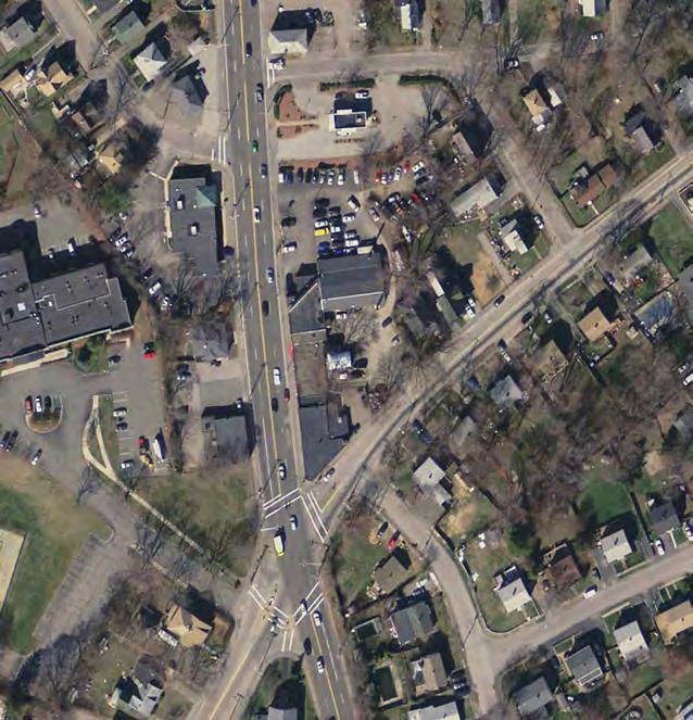
4 Table 1: Participating Audit Team Members Audit Team Member Agency/Affiliation Bill Scully Wing Wong Sergio Musto Lisa Schletzbaum Kush Bhagat Jennifer Inzana Courtney Dwyer Amitai Lipton Green International Affiliates, Inc. Green International Affiliates, Inc. Green International Affiliates, Inc. MassDOT Highway Safety MassDOT Highway Safety MassDOT Highway Safety MassDOT District 6 Bicycle and Pedestrian Coordinator MassDOT District 6 Traffic Zach Veaner MassDOT District 6 Robert Luongo Owen MacDonald Brendan Fogarty Justin Myers Weymouth Planning & Community Development Weymouth Traffic Engineer Weymouth Police Department Weymouth Fire Department Project Location and Description This RSA evaluates safety issues for the Route 3A (Bridge Street) corridor reconstruction project in Weymouth, MA. The project limits along Route 3A (Bridge Street) extend from the intersection with Evans Street to 300 feet east of the driveway for Abigail Adams State Park for an approximate length of 1.4 miles. The RSA focused on the following intersections as well as the segments along Route 3A (Bridge Street) between these intersections: Bridge Street at Sea Street (signalized) Bridge Street at North Street (signalized) Page 2
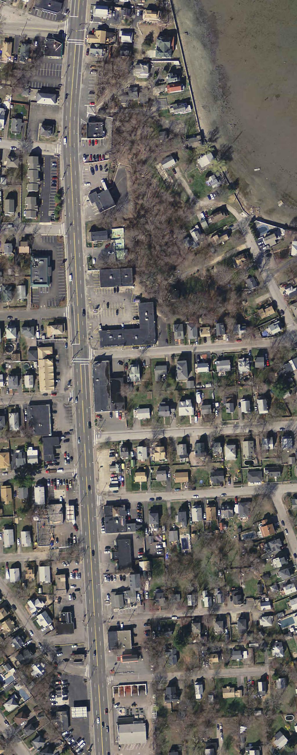
5 Bridge Street at Green Street / Neck Street (signalized) Background research was performed for the above intersections as well as the following three intersections, and the roadway segments between these intersection and to the project limits: Bridge Street at Birchbrow Avenue (signalized) Bridge Street at the primary Riverway Plaza drive (signalized) Bridge Street at the drives to Abigail Adams Park and Riverway Plaza (signalized) Additionally, the intersection of Bridge Street at Evans Street was reviewed, although this intersection is proposed to be reconstructed as part of the ongoing Fore River Bridge Replacement project, MassDOT project No Local crash data was collected and organized into a collision map and collision diagrams. Because existing roadway volumes had not been collected yet, 2010 ADT data for MassDOT count station #8050 on the Fore River Bridge were used in the calculations of crash rates, as well as turning movement count data for North Street from MassDOT Project # The count data and the corresponding crash rates will be updated as it becomes available. Appendix C provides the collision map, collision diagrams, and MassDOT crash rate worksheets for each intersection and roadway segment. Existing Roadway and Intersection Descriptions Route 3A (Bridge Street) Route 3A (Bridge Street) provides access to Route 53 in Quincy and I-93 in Boston to the west, and to Route 228 in Hingham to the east. Bridge Street is a four lane, two-way road and is classified as an Urban Principal Arterial roadway, and is under MassDOT jurisdiction. The roadway carries traffic in the eastwest direction. The posted speed limit on Bridge Street varies from miles per hour. Bridge Street is approximately 50 feet wide between Evans Street and Sea Street, with four foot-wide lanes and two- to three-foot shoulders. The cross-section of Bridge Street is narrower between Sea Street and Neck Street/Green Street, providing four 10-foot travel lanes and no shoulders. East of the intersection with Neck Street/Green Street, travel lanes on Bridge Street are 12 feet wide, 2-foot shoulders are marked, and there is a raised median island or concrete median barriers separating the two directions of travel. At each intersection, each approach of Bridge Street has two travel lanes from which turns are permitted; unless otherwise noted in the following intersection descriptions, no separate turn lanes are provided on Bridge Street except at Riverway Plaza. The project location is shown in Figure 1. Land use adjacent to Bridge Street is commercial, residential, and recreational. There are frequent curb cuts for driveways and side streets along Bridge Street. There are numerous retail and residential properties located within the study area, with Riverway Plaza being the largest. Each intersecting street is owned and maintained by the Town of Weymouth. Evans Street, North Street south of Bridge Street, and Green Street are classified as Urban Minor Arterials; Sea Street, North Street north of Bridge Street, and Neck Street are classified as an Urban Collectors. Page 3


6 N CITY OF QUINCY TOWN OF BRAINTREE PROJECT LOCATION TOWN OF HINGHAM TOWN OF WEYMOUTH SCALE:1"=3000' GREEN INTERNATIONAL AFFILIATES, INC. CIVIL AND STRUCTURAL ENGINEERS Figure 1 Project Location Route 3A Weymouth, MA
7 North Street and Green Street provide direct access to the part of Weymouth south of the peninsula, while all of the other side streets west of Green/Neck Street primarily serve residential traffic or lead to streets that ultimately connect to North Street and Green Street. Sidewalks are present along both sides of Bridge Street between Evans Street and the primary Riverway Plaza drive, and present along the north side of Bridge Street east of the primary plaza drive. There are multiple curb cuts that interrupt the sidewalk along the corridor. Wheelchair ramps with detectable warning panels were constructed in the summer of 2016 as part of a separate project along both sides of Bridge Street. Along the project corridor the only marked crosswalks are present at the signalized intersections. There are no bicycle lanes or markings along the Bridge Street corridor. Shoulders are nonexistent between Sea Street and Green/Neck Street and are narrow (less than three feet wide) west of Riverview Plaza, and there are multiple non-bicycle-safe catch basin grates along the corridor. Bridge Street at Birchbrow Avenue (Signalized) Birchbrow Avenue meets Bridge Street at a signalized three-legged intersection with Bridge Street as the main thoroughfare providing the east-west movements and Birchbrow Avenue serving as the north leg. Lane widths are feet on Bridge Street and 12 feet on Birchbrow Avenue. Sidewalk is present along both sides of Bridge Street. There are crosswalks across Bridge Street east of Birchbrow Avenue and across Birchbrow Avenue at the intersection with Bridge Street. Pedestrian signal heads and pushbuttons are provided at each crosswalk. The signals operate with two vehicular phases and a pushbutton-actuated exclusive pedestrian phase. Bus stops for MBTA bus routes 220, 221, and 222 are located immediately to the east of this intersection in both directions. Bridge Street at Sea Street (Signalized) At this skewed, four-legged intersection, Bridge Street forms the east and west legs while Sea Street forms the northwest and southeast legs. The south leg of Sea Street has a splitter island between the northbound and southbound lanes and another island to provide a channelized right turn. The channelized turn operates under yield control although no signage or signals are present. The lanes on Bridge Street are feet wide west of Sea Street and 10 feet wide east of Sea Street. Lane widths on Sea Street are approximately 20 feet at the intersection. Street parking is allowed on the southbound lane of Sea Street north of the intersection. In the southwest corner of the intersection is open greenspace and a driveway entrance for condominiums; the drive is accessed on the southbound side of Sea Street immediately south of the intersection. A building with small businesses with storefronts is located in the northwest corner. Wood fence and vegetation wrap around the northeast corner, and a church occupies the southeast corner. Crosswalks are present across each leg of the intersection. Five- to eight-foot-wide sidewalk is present along each corner of the intersection and crosswalks with pedestrian pushbuttons are present across each leg, although there are no pushbuttons at the channelized right-turn island. Wheelchair ramps with detectable warning panels were reconstructed in the summer of The signals operate with two vehicular phases and a pushbutton-actuated exclusive pedestrian phase. Page 5
8 No turns are permitted on red for the westbound approach of Bridge Street. The Sea Street traffic movements have concurrent green times, as do both Bridge Street approaches. Pedestrian signal heads and push buttons are located at each corner of the intersection. The push button in the northeast corner faces the grass and is located above the grass behind the sidewalk. Bridge Street at North Street (Signalized) North Street intersects Bridge Street about 1,450 feet east of Sea Street at this four-legged signalized intersection. North Street forms the north and south legs, and Bridge Street forms the east and west legs. The lanes on Bridge Street are each 10 feet wide at this intersection. North Street has one lane at each approach, approximately feet wide. A car dealer occupies the southwest corner of the intersection, a drive-through dry-cleaner is in the northwestern corner, small offices occupy the house in the southeast corner, and a parking lot for townhouses is in the northeast corner. A bus stop for MBTA routes 220 and 221 are located at this intersection. Sidewalk is present along each corner of the intersection, at five to nine feet wide, and crosswalks with pedestrian pushbuttons are present across each leg. Wheelchair ramps with detectable warning panels were reconstructed in the summer of The signals operate with two vehicular phases and a pushbutton-actuated exclusive pedestrian phase. Congestion from the Green Street/Neck Street intersection was observed to back up to the North Street intersection before noon, although this could be the result of a lane closure on Bridge Street east of Green Street. Bridge Street at Green Street/Neck Street (Signalized) Bridge Street meets Green Street and Neck Street at a four-way intersection with Bridge Street as the main thoroughfare. Bridge Street forms the east and west legs, Green Street forms the south leg, and Neck Street forms the north leg. The Bridge Street westbound approach has a channelized right turn approximately 200 feet east of the signalized intersection. Between the channelized right slip lane and Neck Street is a bus pullout area with a bus shelter, for MBTA bus routes 220 and 221. Sidewalks are present along each side of each intersection leg. Crosswalks with pedestrian signal heads and push buttons are present across each leg. Both Bridge Street approaches provide two travel lanes. No turns are permitted in the westbound direction downstream of the channelized turn. The Neck Street and Green Street approaches each have a left-only lane and a through/right lane. Protected left-turn signal phases are provided for the Bridge Street eastbound approach and the Neck Street southbound approach. Right turns on red are prohibited from Neck Street and Green Street. There is an exclusive pedestrian phase, with push button actuation. Bicycle detection is present on each approach. This signal is coordinated with the signals at the Riverview Plaza driveways and at Abigail Adams Park. Bridge Street at Riverway Plaza drive (Signalized) The western driveway to Riverway Plaza and a small drive between two car dealerships form a four-way intersection with Bridge Street. The Bridge Street westbound approach provides an exclusive left-turn Page 6
9 lane in addition to the two travel lanes. The Riverway Plaza Drive northbound approach provides an exclusive left-turn lane and a shared through/right-turn lane. The car dealership drive is unmarked. There is one crosswalk across the east leg, with pedestrian signal heads but no refuge for pedestrians making the approximately 86-foot crossing. No sidewalk is provided along the south side of Bridge Street. There are bus stops along MBTA bus route 220 in both directions immediately west of the intersection. The pedestrian-activated phase is concurrent with that of the plaza drive, but if the plaza drive phase is not activated the pedestrian phase becomes exclusive. The car dealership drive has signal heads and loop detectors, but because one of the adjacent dealerships is empty and access to the other dealer is gated, this phase was not observed to be activated in the field. Left turns are not permitted from the eastbound approach (e.g. into the car dealer drive). Bicycle detection is present on each approach. This signal is coordinated with the signals at North Street/Green Street and at Abigail Adams Park. Bridge Street at Abigail Adams Park (Signalized) Bridge Street intersects the Abigail Adams Park Driveway and an eastbound jughandle to form a fourlegged signalized intersection. The eastbound jughandle accommodates Bridge Street Eastbound leftturns and U-turns, and also provides access to a secondary driveway for Riverway Plaza. Sidewalk is present along the north side of Bridge Street. Bridge Street provides two foot-wide lanes in each direction, whereas the jughandle northbound approach is approximately 25 feet wide and the Abigail Adams Park Driveway southbound approach is approximately 20 feet wide. There are no lane markings on the northbound jughandle and the southbound Abigail Adams Park Driveway approaches. Bicycle detection is present on each approach. This signal is coordinated with the signals at North Street/Green Street and at the primary Riverway Plaza drive. Page 7
10 Audit Observations and Potential Safety Enhancements In conducting the Route 3A Road Safety Audit, existing safety issues and possible corrective actions were identified based on audit team discussions and field observations on Wednesday, September 7, The safety issues that were identified include: Faded pavement markings Intersection geometry deficiencies Non-ADA compliant sidewalks Lack of bicycle facilities Narrow roadway widths Poor access management Substandard signal equipment and phasing Poor/insufficient signage and wayfinding Substandard transit connections Poor geometry at channelized island at Route 3A / Neck Street Illegal parking Many of these issues can or need to be addressed by long term solutions, but some short term improvements were also identified. The following paragraphs describe the issues and possible actions. The identified issues by the RSA team have some similarities and commonalities and consequently, were grouped into major categories. Safety Issue #1. Faded Pavement Markings Observations Crosswalks and stop bars at all intersections are very faded, and the ends of crosswalks do not always match to the wheelchair ramp openings. Lane line and double yellow centerline markings are also faded throughout the corridor, which could lead to driver confusion, and unintended lane encroachment which are potential safety deficiencies. Crosswalks and other pavement markings at the North Street intersection are especially faded, which may be a contributing factor in the three pedestrian crashes along the corridor. The STOP bar locations on the North Street southbound approach may also need to be reviewed as they are located unnecessarily far away from the crosswalk. Enhancements: Restripe all pavement markings within the project limits. Realign crosswalks that currently lead away from wheelchair ramp openings. At the southbound approach of the North Street intersection, relocate the STOP bar location to be four feet from the crosswalk per the latest edition of the Manual on Uniform Traffic Control Devices (MUTCD). This crosswalk should also be realigned and be widened. Page 8

11 Image 1: This crosswalk across North Street does not align with the wheelchair ramps. Safety Issue #2. Intersection Geometry Deficiencies Observations: At the Sea Street intersection, the vehicles turning left onto Sea Street from the Route 3A approaches appear to conflict head-on due to the skewed intersection layout. At the North Street intersection, the northeast curb radius is too tight, requiring vehicles to almost stop to turn. This movement was observed in the field to have nearly caused a rear-end crash. Because Green Street and Neck Street are somewhat offset (by approximately feet) from each other, the approach and receiving lanes are not aligned, which could lead to sideswipe crashes in the middle of the intersection as drivers align themselves to the receiving lanes. Enhancement: At the Route 3A/Sea Street intersection, slightly realign the Sea Street approaches to eliminate conflicting left-turn movements from Route 3A. At the Route 3A/North Street intersection, increase the curb radius at the northeast corner. At the Route 3A / Green Street / Neck Street intersection, determine if it is possible to create a more straight alignment traveling northbound or southbound along the side streets. Page 9

12 Safety Issue #3 Non-ADA Compliant Sidewalks (Corridor Wide) Observations: Route 3A sidewalks have issues mostly at narrow roadway areas and at some crosswalk locations. Sidewalk along the north side of Route 3A between Sea Street and North Street has overgrown vegetation extending nearly out to the roadway which could force pedestrians into the roadway to bypass this segment of the sidewalk. Sidewalk widths are also reduced by the presence of utility poles. Sidewalk grading issues were also observed. The majority of the sidewalk cross-slopes appear to exceed the maximum ADA allowable cross-slope of 2 percent. Wheelchair ramps were observed at a few locations to have lips between the ramp opening and edge of roadway (such as at Blackstone Street). This is not in accordance with ADA standards, which require a flush transition. Corner ramps such as those along the north side of the North Street intersection were observed to open toward one crosswalk but have raised curb at the end of the crosswalk in the perpendicular direction. Image 2: Some recently-installed wheelchair ramps have a lip between the edge of roadway and the ramp entrance, which is not in accordance with ADA standards requiring a flush transition. Page 10

13 Image 3: Sidewalk between Sea Street and North Street is narrow with overhanging vegetation. Enhancements: Trim overgrown vegetation along sidewalks to provide adequate clearance width. Reconstruct existing sidewalks to be concrete and meet ADA and AAB standards. Reconstruct ADA-compliant curb ramps so that the ramp opens properly at each crosswalk end. Safety Issue #4 Lack of Bicycle Facilities (Corridor Wide) Observations: There are no bicycle lanes along the Route 3A corridor and shoulders are narrow or non-existent to accommodate bicycles. The only bicycle accommodations that are currently provided in the study area are actuation loops at the Neck Street / Green Street, Riverway Plaza, and Abigail Adams State Park traffic signals. Bicyclists were observed riding on the sidewalk along the north side of Route 3A. Page 11
14 Enhancements: Provide a continuous bicycle lane or wide bicycle-accommodating shoulder in each direction along the entire length of Route 3A, if feasible. Consider providing alternative bicycle routes if a bicycle lane cannot be added along portions of Route 3A due to site constraints. Add bicycle detection to the traffic signals at the Birchbrow Street, Sea Street, and North Street intersections on all approaches and provide appropriate signage and pavement markings to indicate where bicyclists are to wait. Encouraging slower travel speeds (see comments on speed limits) along the corridor will improve the safety of bicycling along the corridor, as well. Safety Issue #5 Narrow Roadway Widths Observations: Shoulders are narrow (less than three feet wide) throughout the corridor west of Sea Street and are nonexistent between Sea Street and Green Street / Neck Street. Wider shoulders would benefit both bicyclists and law enforcement, since the parked vehicles partially block the right travel lane and essentially block the usage of the right lane. Travel lane widths are approximately ten feet between Sea Street and Green Street / Neck Street. It was observed that the narrow lane widths force buses and large trucks to encroach into adjacent travel lanes as these vehicles were trying to gain clearance from the utility poles and signs located within the adjacent sidewalk. This may be a factor in the 14 sideswipe crashes that occurred along the corridor. Enhancement: Increase roadway widths on Route 3A, especially between and including the intersections at Sea Street and Green Street / Neck Street. The expanded roadway cross section would require widening the shoulders to 5 feet (also to accommodate bike lanes, see the previous issue) and widen travel lanes to be 11 feet to comply with the MassDOT Complete Streets Policy and standards. Safety Issue #6: Poor Access Management Observations: Driveway openings are excessively wide, poorly defined, and densely spaced on Route 3A. This results in numerous vehicular conflict points along the corridor. The presence of these conflict points results in an increased risk of angle and rear-end collisions. Excluding signalized intersections, there were 18 reported angle collisions and 18 reported rear-end collisions in within the project limits. Curb cuts near the North Street intersection, among other locations, were also noted to be excessively wide the curb cuts at the dry cleaners are approximately 50 feet wide, and the westernmost curb cut is shared as a driveway opening for several houses. Drivers also turn left out of driveways onto Route 3A, which requires them to cross in front of two opposing lanes of traffic. This is especially a concern between the Dunkin Donuts and the Citgo gas station along the south side of Bridge Street between Green Street / Neck Street and Riverway Plaza, where Bridge Street is not physically divided. At the Green Street intersection, there is also concern that traffic could be stopped when drivers from the Route 3A eastbound Page 12

15 direction cross Green Street to access the southern Dunkin Donuts driveway while there are vehicle queues stacked at the Green Street approach. This condition was observed during the RSA. Enhancement: Consolidate driveways where possible. At businesses or small plazas that currently have two driveways, discuss with property owners the possibility of eliminating a curb cut or alternatively converting the driveways to a one-way traffic pattern. This will reduce the number of conflict points along Route 3A. Discuss with property owners the possibility of closing curb cuts and/or providing internal connections between adjacent properties. Narrow the width of curb cuts, especially near the intersections. Another option to help reduce conflict points along Route 3A is to restrict left turns from curb cuts to prevent drivers crossing opposing lanes of traffic on a four-lane roadway. In the longer term, it is anticipated that changing zoning to encourage mixed-use or smart-growth mixtures of residences and businesses will help limit the number of curb cuts needed along Route 3A. Shift the Dunkin Donuts driveway along Green Street further south of the intersection with Bridge Street or add Do Not Block Intersection markings at this driveway entrance. Considering that traffic from the westbound direction of Route 3A (via the jughandle) and Neck Street can turn right into the Dunkin Donuts Bridge Street driveway, it might also be advantageous to prohibit left turns into the Dunkin Donuts driveway from Green Street. Image 4: The entrance curb cut to the dry cleaners at the North Street intersection is approximately 50 feet wide and the pavement at the driveway entrance is in poor condition. Page 13
16 Safety Issue #7: Substandard Signal Equipment and Phasing Observations at Sea Street / Route 3A Intersection: A pedestrian push button in the northeast corner is missing. See the general corridor comments for more observations about pedestrian signal equipment. The signal system does not have preemption equipment. Observations at North Street / Route 3A Intersection: On the Route 3A westbound approach, a single signal head is mounted over the crosswalk of the west intersection leg and does not have the minimum separation distance of 40 feet (per standards of the latest edition of the MUTCD) between the stop bar and the signal heads. This creates a visibility issue since the signal head for the westbound approach is too high for drivers stopped near the STOP bar to see on this approach. A second signal head for the westbound approach is mounted on the southeast corner of the intersection and it is located outside of the MUTCD recommended cone of vision. The improper signal head locations may be a factor in the five red light running crashes and the nine rear-end crashes reported at this intersection from Route 3A left-turning vehicles have difficulty making these turning movements due to the lack of gaps in traffic. The crash data shows that 12 of the 46 reported angle crashes from at this intersection involved left-turning westbound vehicles, and that there were four times as many reported crashes involving left turns from the westbound movement than crashes involving left turns from the eastbound movement. The Route 3A approaches have concurrent phases and there is no protected phase for this movement/approach. During the time of observation, an inductive loop for the North Street southbound approach is believed to have been activated when a driver turning from Route 3A onto North Street drove over part of the loop, causing a false call to be made for the North Street approach and increasing overall intersection delay. The signal system does not have preemption equipment. The clearance timing interval was observed to be short/substandard. Observations at Green Street / Neck Street / Route 3A Intersection: The signal heads for the Route 3A westbound approach display green arrows, but they should be green balls since there are opposing left-turn movements from the Route 3A eastbound approach permitted during the same phase. There are two sign mounting brackets on the southeast corner mast arm. The signs that were once installed on these brackets are missing (review of old Google Streetview photos shows that a left turn yield on green sign was mounted on this arm for the Neck Street approach). The No Turn on Red mounted over/for the eastbound Route 3A movement is partially blocked by one of the signal heads facing the Neck Street approach. Page 14

17 The signal system does not have preemption equipment. Observations Along Corridor: The signalized intersections within the project limits lack pedestrian signal heads with countdown timers, and do not provide accessible features. Many of the pedestrian push buttons are missing, not ADA/AAB compliant, and/or are incorrectly installed. The signal systems do not have preemption equipment. Existing signal systems are not coordinated. Most of the signal heads along the corridor do not have backplates. Some of the backplates for the signal heads at the Green Street/Neck Street intersection and (as observed during prior field review conducted in May 2016) the Birchbrow Avenue intersection are damaged. The reduced visibility of the signal heads may be a contributing factor in the eight red light running crashes reported along the corridor from Enhancement: At the North Street / Route 3A intersection, the yellow and all-red clearance times should be checked and updated to current MassDOT standards. Providing an advance protected left turn phase for the westbound traffic on Route 3A will help left-turning movements on this approach. Adjust the location of the vehicle signal heads at this intersection to meet the standards of the latest edition of the MUTCD. Review and adjust loop detector settings (short delay timing) to avoid unnecessary false calls. Image 5: This mast arm at North Street has a signal head for the westbound approach too close (almost above) the stop line, a pedestrian signal head without a countdown, and a pushbutton facing the wrong way. Page 15
18 At the Green Street / Neck Street / Route 3A intersection, replace the signal heads for the westbound direction to have circular green indications. Remove the sign mounting brackets that are no longer necessary. Check the mountings for the remaining mast arm-mounted signage, and relocate as needed to avoid visibility blockage. For corridor wide improvements, pedestrian signal equipment compliant with the latest edition of the MUTCD should be installed for all crosswalks at the signalized intersections, with accessible pedestrian features per current MassDOT policy. Traffic signals should be coordinated within the corridor in a closed loop system to improve overall traffic operations. Backplates should be installed or re-installed on the traffic signal heads as necessary throughout the corridor. Safety Issue #8: Poor/Insufficient Signage and Wayfinding Observations: Although Route 3A is a busy corridor located in close proximity to several beaches and state parks. However, there are no wayfinding signs along Route 3A within the project limits to guide drivers to these destinations. Route marker signs are absent, and speed limit signs in either travel direction are provided at only one location within the project corridor. Aside from a variable message sign on the Hingham side of the Back River Bridge that alerts motorists to divert to Green Street or North Street during closures of the Fore River Bridge, there is no other signage that alerts drivers of the Fore River Bridge closure in advance of boat crossings. Most of the street name signs are located too far back from Route 3A and are difficult to see for drivers on Route 3A as the signs are blocked by vegetation, buildings, utility poles, etc. Other regulatory and warning signs within the project limits are difficult to read as the sign panels are old and faded. This may cause vehicles to shift lanes suddenly. Enhancement: Install wayfinding signage for beaches, state parks, and state boat ramps along the corridor. Add route marker and speed limit reinforcement signs along the corridor. Install solar-powered speed display signs for traffic calming. Install additional real-time display signs alerting drivers to (scheduled) bridge closures. Trim vegetation around street name signs and relocate, if necessary, to more visible locations. The installation of advanced street name signage is also recommended along approaches to major intersections. Install overhead street name signs on the mast arms at the signalized intersections. Replace old and faded regulatory and warning signs throughout the corridor to meet the standards of the latest edition of the MUTCD. Page 16
19 Safety Issue #9: Substandard Transit Connections Observations: There are only three bus shelters along the project corridor. Bus stop signs located at multiple locations are faded and are barely visible. The existing bus stops are not accessible. There are bus stop locations along the corridor that are not near crosswalks, such as the bus stop on the north side of Bridge Street east of Blackstone Rd, and the bus stop at St. Jerome Parish on the north side of Bridge Street. It was mentioned that pedestrians were known to cross Bridge Street at unmarked locations that are not expected by motorists in order to walk to/from bus stops. During the morning and afternoon there are many vehicle trips for student drop-offs and pick-ups at the St. Jerome Elementary School, which adds to the amount of turning traffic at the Green Street / Neck Street intersection when school is in session. Enhancement: Install additional bus shelters along the corridor and install the bus shelters near existing crosswalks, and upgrade stops to be accessible. Replace the existing faded bus stop/route signage. For the private St. Jerome Elementary School, consider providing school buses to help reduce the number of trips entering and exiting the school and overall vehicle trips. The primary student pick-up/drop-off location for St. Jerome Elementary School is off of Lovell Street at the rear of the St. Jerome property. Pick-ups and drop-offs on Bridge Street could be prohibited to enhance access management. Safety Issue #10: Poor Geometry at Channelized Island at Route 3A / Neck Street Observations: There were several issues noted with the turn lane between the westbound Route 3A movement and Neck Street. Trees and shrubs within the island have grown to be at the approximate driver s eye height, restricting sight distances for vehicles exiting the channelized lane. Sight distance for drivers turning left onto Neck Street is restricted by the horizontal curve on Neck Street located just north of the channelized island. It is difficult to see oncoming traffic from Neck Street until a vehicle has entered this horizontal curve. There were three crashes involving vehicles turning left from the channelized turning lane onto Neck Street. The geometry of the island where it intersects Neck Street has a sharp skewed angle that favors right turn movements and the angle does not encourage the left turn movements. Vehicle queues from the southbound approach of Neck Street were observed to extend to the end of the channelized island resulting in the blocking of left turning vehicles from merging onto Neck Street from the channelized westbound lane. The STOP sign on the left side of the channelized lane is obstructed by tree branches and this sign is not visible until the driver is near the stop bar. There is no advance signage informing westbound drivers on Page 17

20 Route 3A that left turns are prohibited at the Neck Street/Green Street intersection and that drivers intending to make a left turn movement must use the channelized lane. Enhancement: Trim trees and shrubs in the vicinity of the channelized island to eliminate sight restrictions. Realign the channelized lane/island to approach Neck Street closer to a 90-degree angle to help improve overall sight distance and left turn movements. Improve signal operations to control queue length such that the queue on Neck Street would not block left turn vehicles from the channelized lane. Clear vegetation near the STOP sign location to eliminate the sight distance restriction. Install advance signage informing westbound drivers on Route 3A that left turns are prohibited at the intersection and that drivers intending on making a left turn movement must use the channelized lane. Safety Issue #11: Illegal Parking Observations: Parking in the right lane on the westbound approach of Route 3A was observed adjacent to the shops immediately west of Sea Street (between Bridge-Wey Tailors and Cleaners and Fore River Holistic Therapy and Skin Care). As a result, westbound traffic must merge into the left lane immediately after Image 6: Illegal parking (see pick-up truck) on the westbound right lane west of Sea Street restricts vehicle flow on Route 3A. Page 18
21 crossing the Sea Street intersection. Vehicles unexpectedly changing lanes to avoid the parked vehicles may cause sideswipe crashes. There is no known regulation record allowing parking on Route 3A in this area. There is a narrow (approximately one-foot-wide) shoulder present on Route 3A at this location. There is a gravel parking lot behind these shops off of Sea Street. Enhancement: Install No Parking signs at this area and provide enforcement of this rule. Page 19
22 Summary of Road Safety Audit Based on the audit team members review of observations and discussions, issues and possible solutions were identified that could help reduce safety risks along the Route 3A corridor. Table 2 defines estimated safety payout, time frame, cost, and responsibility. The issues and possible solutions from the previous sections are summarized in Table 3. Safety Payoff: the enhancement could reduce the number of crashes along the corridor by a low (<30%), medium (30% - 70%), or high (>70%). Time frame: the enhancement can be completed within a time frame of short-term (<1 year), mid-term (1-3 years), or long-term (>3 years). Cost: cost is estimated to be within one of three categories of cost of low ($10,000), medium ($10,001- $50,000) or high (>$50,000). Responsibility: which entity or organization will be responsible for completing the work. Table 2: Estimated Time Frame and Costs Breakdown Time Frame Costs Short-Term <1 Year Low <$10,000 Mid-Term 1-3 Years Medium $10,001-$50,000 Long-Term >3 Years High >$50,000 Page 20
23 Table 3: Potential Safety Enhancement Summary Safety Issue Potential Safety Enhancement Safety Payoff Time Frame Cost Responsible Agency Faded Pavement Markings Restripe all existing crosswalks. low Short-term medium MassDOT Faded Pavement Markings Faded Pavement Markings Intersection Geometry Deficiencies Intersection Geometry Deficiencies Intersection Geometry Deficiencies Non ADA-compliant sidewalks / Maintenance Items Non ADA-compliant sidewalks Lack of Bicycle Facilities, Narrow Roadway Widths Restripe all existing lane lines and shoulder lines. Review STOP bar locations at the Route 3A / North Street intersection and restripe as necessary. Consider slightly realigning the Sea Street approaches at the Route 3A / Sea Street intersection. Increase the curb radius on the northeast corner at the Route 3A / North Street intersection. Review and realign Green Street and Neck Street alignments at Route 3A. Trim vegetation along and over sidewalks. Reconstruct sidewalk and wheelchair ramps to be fully ADA/MAAB-compliant and open properly at crosswalks. Provide a continuous bicycle lane, or a shoulder wide enough to accommodate bicyclists, along both sides of the entire Route 3A corridor. Roadway widening would be needed west of Green Street / Neck Street. medium Short-term medium MassDOT medium Short-term low MassDOT medium Long-term high MassDOT medium Mid-term medium MassDOT medium Long-term high MassDOT medium Short-term low MassDOT low Long-term high MassDOT medium Long-term high MassDOT Page 21
24 Table 3 (continued): Potential Safety Enhancement Summary Safety Issue Potential Safety Enhancement Safety Payoff Time Frame Cost Responsible Agency Lack of Bicycle Facilities Narrow Roadway Widths Poor Access Management Install bicycle detection at the Birchbrow Avenue, Sea Street, and North Street intersections. Provide appropriate signage and pavement markings to indicate where bicyclists are to wait. Widen lanes on Route 3A to be 11 feet wide throughout the corridor. Involves road widening between and including Sea Street and Green Street / Neck Street. Consolidate driveways where possible, especially west of North Street. Coordinate with business owners on removing curb cuts, shifting driveways to one-way flows, and/or providing internal connections with adjacent properties. low Mid-term medium MassDOT high Long-term high MassDOT medium Long-term high Poor Access Management Narrow curb cut widths. medium Mid-term high Poor Access Management Poor Access Management Poor Access Management Restrict left turns from curb cuts along the Route 3A corridor. Along Route 3A change zoning to encourage mixed-use or smartgrowth mixtures of residences and businesses Shift Dunkin Donuts driveway on Green Street south and add Do Not Block Intersection pavement markings at driveway entrance. high Short-term low MassDOT / property owners MassDOT / property owners MassDOT / property owners high Long-term n/a Town of Weymouth low Mid-term medium MassDOT / Town of Weymouth / Dunkin Donuts Page 22
25 Table 3 (continued): Potential Safety Enhancement Summary Safety Issue Potential Safety Enhancement Safety Payoff Time Frame Cost Responsible Agency Substandard Signal Equipment and Phasing Substandard Signal Equipment and Phasing Substandard Signal Equipment and Phasing Substandard Signal Equipment and Phasing Substandard Signal Equipment and Phasing Substandard Signal Equipment and Phasing / Poor/Insufficient Signage and Wayfinding Substandard Signal Equipment and Phasing Check yellow and all-red clearance timings at all approaches to the Route 3A / North Street intersection and update to current MassDOT standards. Provide an advance phase for westbound Route 3A traffic at the North Street intersection for leftturning westbound traffic. Review and adjust loop detector settings (short delay timing) at the Route 3A / North Street intersection. Review and adjust locations of signal heads at the Route 3A / North Street intersection. Replace the signal heads for the westbound direction to have circular green indications on the westbound Route 3A approach at Green Street / Neck Street. At the Route 3A / Green Street / Neck Street intersection, remove the sign mounting brackets that are no longer necessary. Check the mountings for the remaining mast arm-mounted signage, and relocate as needed to avoid visibility blockage. Install 2009 MUTCD compliant countdown pedestrian signals at all crosswalks at all six project signalized intersections. medium Short-term low MassDOT medium Short-term low MassDOT low Short-term low MassDOT low Mid-term medium MassDOT low Short-term low MassDOT low Short-term low MassDOT low Mid-Term high MassDOT Page 23
26 Table 3 (continued): Potential Safety Enhancement Summary Safety Issue Potential Safety Enhancement Safety Payoff Time Frame Cost Responsible Agency Substandard Signal Equipment and Phasing Substandard Signal Equipment and Phasing Poor/Insufficient Signage and Wayfinding Poor/Insufficient Signage and Wayfinding Poor/Insufficient Signage and Wayfinding Poor/Insufficient Signage and Wayfinding Poor/Insufficient Signage and Wayfinding Poor/Insufficient Signage and Wayfinding Poor/Insufficient Signage and Wayfinding Poor/Insufficient Signage and Wayfinding Substandard Transit Connections Coordinate the traffic signals within the project limits in a closed loop system to improve overall traffic operations. Install optical emergency vehicle detection and pre-emption at all signalized intersections along the corridor within project limits. Add route marker and speed limit signage. Determine locations and need for solar-powered speed display signs. Install additional wayfinding signage for beaches, state parks, and state boat ramps along the corridor. Consider installing real-time (Fore River) bridge closure display signs. Trim vegetation around and relocate street name signs as necessary to more highly visible locations. Install additional advance street name signage for major intersections along the corridor. Install overhead street-name signage at signalized intersections. Replace existing faded roadway signage along the corridor. Install additional bus shelters along the corridor. low Mid-term medium MassDOT low Short-term medium MassDOT low Short-term low MassDOT medium Short-term medium MassDOT low Short-term low MassDOT low Short-term medium MassDOT low Short-term low MassDOT low Short-term low MassDOT low Short-term low MassDOT low Short-term medium MassDOT low Mid-term high MassDOT / MBTA Page 24
27 Table 3 (continued): Potential Safety Enhancement Summary Safety Issue Potential Safety Enhancement Safety Payoff Time Frame Cost Responsible Agency Substandard Transit Connections Substandard Transit Connections Substandard Transit Connections Poor Geometry at Channelized Island at Route 3A / Neck Street Poor Geometry at Channelized Island at Route 3A / Neck Street Poor Geometry at Channelized Island at Route 3A / Neck Street Poor Geometry at Channelized Island at Route 3A / Neck Street Poor Geometry at Channelized Island at Route 3A / Neck Street / Improve Signage and Wayfinding Illegal Parking Upgrade stops to be made more handicapped-accessible. Replace the existing faded bus stop/route signage. Consider purchasing/funding school buses to reduce the number of trips entering and exiting St. Jerome Elementary school Trim trees and shrubs in vicinity of the channelized turn. Realign the channelized lane/island to approach Neck Street closer to a 90-degree angle. Consider installing crosshatch Do Not Block Intersection markings on Neck Street in vicinity of the exit from the turn lane. Position STOP signs to be more visible to drivers on the turn lane. Install advance signage telling westbound-turning drivers to use the channelized turn lane leading to Neck Street. Install No Parking signs along Route 3A between Bridge-Wey Tailors and Cleaners and Fore River Holistic Therapy and Skin Care, and increase enforcement low Mid-term high MassDOT / MBTA low Short-term low MassDOT / MBTA medium Short-term medium low Short-term low medium Long-term high medium Short-term low low Short-term low low Short-term low medium Short-term low Town of Weymouth / St. Jerome Parish MassDOT / Town of Weymouth MassDOT / Town of Weymouth MassDOT / Town of Weymouth MassDOT / Town of Weymouth MassDOT / Town of Weymouth MassDOT / Town of Weymouth / property owners Page 25
28 Appendix A. RSA Meeting Agenda
29 Road Safety Audit Meeting Location: Weymouth Mary McElroy Meeting Room, McCulloch Building September 7, :00 AM 12:00 PM Type of meeting: Attendees: Please bring: Route 3A, Bridge Street Road Safety Audit Invited Participants to Comprise a Multidisciplinary Team Thoughts and Enthusiasm!! 9:00 AM Welcome and Introductions 9:15 AM Review of Site Specific Material Crash Summaries provided in advance Existing Geometries and Conditions 10:00 AM Visit the Site Drive to LOCATION As a group, review site & identify areas for improvement 11:30 AM Post Visit Discussion / Completion of RSA Discuss observations and finalize findings Discuss potential improvements and finalize recommendations 12:00 PM Adjourn for the Day but the RSA has not ended Instructions for Participants: Before attending the RSA on DATE, participants are encouraged to drive through the project area and complete/consider elements on the RSA Prompt List (enclosed) with a focus on safety. All participants will be actively involved in the process throughout. Participants are encouraged to come with thoughts and ideas, but are reminded that the synergy that develops and respect for others opinions are key elements to the success of the overall RSA process. After the RSA meeting, participants will be asked to comment and respond to the document materials to assure it is reflective of the RSA completed by the multidisciplinary team. Route 3A Weymouth Road Safety Audit
30 Appendix B. RSA Audit Team Contact List
31 Participating Audit Team Members Date: September 7, 2014 Location: Weymouth, MA Audit Team Members Agency/Affiliation Address Phone Number Bill Scully Green International Affiliates, Inc. (978) Wing Wong Green International Affiliates, Inc. (978) Sergio Musto Green International Affiliates, Inc. (978) Lisa Schletzbaum Kush Bhagat Jennifer Inzana Courtney Dwyer Amitai Lipton MassDOT Highway Safety MassDOT Highway Safety MassDOT Highway Safety MassDOT District 6 Bicycle and Pedestrian Coordinator MassDOT District 6 Traffic Zach Veaner MassDOT District 6 Robert Luongo Owen MacDonald Brendan Fogarty Justin Myers Weymouth Planning & Community Development Weymouth Traffic Engineer Weymouth Police Department Weymouth Fire Department lisaschletzbaum@state. ma.us kush.bhagat@state.ma. us jennifer.inzana@state. ma.us courtney.dwyer@state. ma.us amitai.lipton@state.ma. us zachary.veaner@state. ma.us rluongo@weymouth.ma.us omacdonald@weymout h.ma.us bfogarty@weymouth.m a.us jmyers@weymouth.ma. us (857) (857) (857) (857) (857) (857) (781) (781) (781) (781)
32
33 Appendix C. Detailed Crash Data
 North Riverway Plaza")
 : CRASH RATE CALCULATION : 3.")
34 SEGMENT CRASH RATE WORKSHEET CITY/TOWN : Weymouth COUNT DATE : 9/14/16-9/15/16 DISTRICT : 6 ~ SEGMENT DATA ~ ROADWAY NAME: Route 3A START POINT:Evans Street END POINT: 300 Feet East of Abigail Adams State Park Driveway FUNCTIONAL CLASSIFICATION OF ROADWAY: Urban Principal Arterial ROADWAY DIAGRAM (LABEL ROADWAY AND CROSS STREETS) North Riverway Plaza AVERAGE DAILY TRAFFIC SEGMENT LENGTH IN MILES ( L ): AVERAGE DAILY TRAFFIC VOLUME ( V ): ,107 AVERAGE # OF # OF TOTAL # OF CRASHES: CRASHES PER YEAR ( YEARS : A ) : CRASH RATE CALCULATION : 3.87 RATE = ( A * 1,000,000 ) ( L * V * 365 ) Comments : Project Title & Date: Weymouth Route 3A (Bridge Street) Functional Design Report, Sept. 2016

35 LEGEND APPROXIMATE CRASH LOCATION 11 (XX) CRASH NUMBER (CRASH TYPE) SCALE 1" = 200'
 GREEN ST ATHENS ST ROUTE 3A NORTH ST ROUTE 3A CRASH NUMBER (CRASH TYPE) SCALE 1\" =")
36 NECK ST ST NO R TH R NE TO KS AC BL LOVELL ST D LEGEND APPROXIMATE CRASH LOCATION 11 (XX) GREEN ST ATHENS ST ROUTE 3A NORTH ST ROUTE 3A CRASH NUMBER (CRASH TYPE) SCALE 1" = 200'


37 ABIGAIL ADAMS STATE PARK ROUTE 3A WEYMOUTH HINGHAM RIVERWAY PLAZA LEGEND APPROXIMATE CRASH LOCATION 11 (XX) CRASH NUMBER (CRASH TYPE) SCALE 1" = 200'
ROAD SAFETY AUDIT. Route 38 from Route 62 to Woburn Town Line. Town of Wilmington. April 10, Prepared For: MassDOT
 ROAD SAFETY AUDIT Route 38 from Route 62 to Woburn Town Line Town of Wilmington April 10, 2017 Prepared For: MassDOT Prepared By: Green International Affiliates, Inc. 239 Littleton Road, Suite 3, Westford,
ROAD SAFETY AUDIT. Blue Hill Avenue (Route 28) and Warren Street High Crash Locations City of Boston. November 1, 2016
 and Warren Street High Crash Locations City of Boston. November 1, 2016") ROAD SAFETY AUDIT Blue Hill Avenue (Route 28) and Warren Street High Crash Locations City of Boston November 1, 2016 Prepared For: MassDOT Highway Division Prepared By: BETA Group, Inc. Table of Contents
ROAD SAFETY AUDIT Blue Hill Avenue (Route 28) and Warren Street High Crash Locations City of Boston November 1, 2016 Prepared For: MassDOT Highway Division Prepared By: BETA Group, Inc. Table of Contents
ROAD SAFETY AUDIT. State Road (Route 6) Corridor Town of Dartmouth. March Prepared For: MassDOT
 Corridor Town of Dartmouth. March Prepared For: MassDOT") ROAD SAFETY AUDIT State Road (Route 6) Corridor Town of Dartmouth March 2015 Prepared For: MassDOT Prepared By: McMahon Associates, Inc. 300 Myles Standish Blvd. Suite 201 Taunton, MA 02780 Table of Contents
ROAD SAFETY AUDIT State Road (Route 6) Corridor Town of Dartmouth March 2015 Prepared For: MassDOT Prepared By: McMahon Associates, Inc. 300 Myles Standish Blvd. Suite 201 Taunton, MA 02780 Table of Contents
ROAD SAFETY AUDIT. May 18, Prepared For: MassDOT. On Behalf Of: Town of Milford
 ROAD SAFETY AUDIT East Main Street (Route 16) at Medway Road (Route 109), East Main Street (Route 16) at Quarry Square Driveways, East Main Street (Route 16) at Beaver Street/ Fortune Boulevard Town of
ROAD SAFETY AUDIT. Granite Avenue at Interstate 93 Ramps. Town of Milton. May 22, Prepared for: MassDOT
 ROAD SAFETY AUDIT Granite Avenue at Interstate 93 Ramps Town of Milton May 22, 2017 Prepared for: MassDOT Prepared by: Toole Design Group 2 Oliver Street, Suite 305 Boston, MA 02109 Table of Contents Background...
ROAD SAFETY AUDIT. County Street at Hart Street. City of Taunton. January 30, Prepared For: Massachusetts Department of Transportation
 ROAD SAFETY AUDIT County Street at Hart Street City of Taunton January 30, 2015 Prepared For: Massachusetts Department of Transportation Prepared By: Toole Design Group 33 Broad Street, 4 th Floor Boston,
ROAD SAFETY AUDIT. Centre Street (Route 123) at Plymouth Street. Municipality of Brockton. November, Prepared For: MassDOT
 at Plymouth Street. Municipality of Brockton. November, Prepared For: MassDOT") ROAD SAFETY AUDIT Centre Street (Route 123) at Plymouth Street Municipality of Brockton November, 2017 Prepared For: MassDOT On Behalf Of: City of Brockton Prepared By: Old Colony Planning Council 70 School
ROAD SAFETY AUDIT Centre Street (Route 123) at Plymouth Street Municipality of Brockton November, 2017 Prepared For: MassDOT On Behalf Of: City of Brockton Prepared By: Old Colony Planning Council 70 School
ROAD SAFETY AUDIT. Boston Road (Route 20) at Parker Street and Pasco Road to Dumaine Street City of Springfield Town of Wilbraham.
 at Parker Street and Pasco Road to Dumaine Street City of Springfield Town of Wilbraham.") ROAD SAFETY AUDIT Boston Road (Route 2) at Parker Street and Pasco Road to Dumaine Street City of Springfield Town of Wilbraham October 4, 212 Prepared For: MassDOT Highway Division Prepared By: BETA Group,
ROAD SAFETY AUDIT Boston Road (Route 2) at Parker Street and Pasco Road to Dumaine Street City of Springfield Town of Wilbraham October 4, 212 Prepared For: MassDOT Highway Division Prepared By: BETA Group,
ROAD SAFETY AUDIT. Needham Street and Highland Avenue Corridor. City of Newton and Town of Needham. March 2014
 ROAD SAFETY AUDIT Needham Street and Highland Avenue Corridor City of Newton and Town of Needham March 2014 Prepared for: Massachusetts Department of Transportation Prepared by: Howard/Stein-Hudson Associates
Appendix T CCMP TRAIL TRAFFIC & TRANSPORTATION DESIGN STANDARD
 Appendix T CCMP 3.3.4 TRAIL TRAFFIC & TRANSPORTATION DESIGN STANDARD 3.3.4 Trail Traffic and Transportation Design Multi-use trails have certain design standards, which vary depending on the agency that
ROAD SAFETY AUDIT. Route 202 (East State Street)/School Street & Route 202 (West State Street)/Pleasant Street/Amherst Street Town of Granby
/School Street & Route 202 (West State Street)/Pleasant Street/Amherst Street Town of Granby") ROAD SAFETY AUDIT Route 202 (East State Street)/School Street & Route 202 (West State Street)/Pleasant Street/Amherst Street Town of Granby March 2013 Prepared for: Massachusetts Department of Transportation
ROAD SAFETY AUDIT Route 202 (East State Street)/School Street & Route 202 (West State Street)/Pleasant Street/Amherst Street Town of Granby March 2013 Prepared for: Massachusetts Department of Transportation
ROAD SAFETY AUDIT. Route 114 at Interstate I-495 Northbound Ramps. City of Lawrence. July 30, 2015
 ROAD SAFETY AUDIT Route 114 at Interstate I-495 Northbound Ramps City of Lawrence July 30, 2015 Prepared For: Massachusetts Department of Transportation Prepared By: Toole Design Group 33 Broad Street,
ROAD SAFETY AUDIT. Providence Street (Route 122A) at McKeon Road/Millbury Street. City of Worcester. July 14, Prepared For: MassDOT
 at McKeon Road/Millbury Street. City of Worcester. July 14, Prepared For: MassDOT") ROAD SAFETY AUDIT Providence Street (Route 122A) at McKeon Road/Millbury Street City of Worcester July 14, 2016 Prepared For: MassDOT Prepared By: Stantec Consulting Services, Inc. Burlington, Massachusetts
ROAD SAFETY AUDIT Providence Street (Route 122A) at McKeon Road/Millbury Street City of Worcester July 14, 2016 Prepared For: MassDOT Prepared By: Stantec Consulting Services, Inc. Burlington, Massachusetts
ROAD SAFETY AUDIT. Route 16 at Interstate 395 Town of Webster. October Prepared For: MassDOT
 ROAD SAFETY AUDIT Route 16 at Interstate 395 Town of Webster October 2015 Prepared For: MassDOT Prepared By: McMahon Associates, Inc. 300 Myles Standish Blvd. Suite 201 Taunton, MA 02780 Table of Contents
Multi-Modal Traffic Analysis. Parisi and Associates
 Mill Valley to Corte Madera Bicycle and Pedestrian Corridor Study Appendix D: Multi-Modal Traffic Analysis Prepared by Parisi and Associates August 2009 Appendix D - Multi-Modal Traffic Analysis Table
ROAD SAFETY AUDIT MDM. Columbia Road at Dorchester Avenue. Dorchester, MA 10/14/2016. Prepared For: MassDOT. On Behalf Of: Edens
 ROAD SAFETY AUDIT Columbia Road at Dorchester Avenue Dorchester, MA 10/14/2016 Prepared For: MassDOT On Behalf Of: Edens Prepared By: MDM Transportation Consultants, Inc. 28 Lord Road Suite 280 Marlborough,
Orange Center Elementary School
 Drag and drop pic and stretch/crop to the limits of the blue rectangle (delete this text box) Orange Center Elementary School Drag and drop pic and stretch/crop to the limits of the blue rectangle (delete
AGENDA ITEM 6 D THOMASVILLE ROAD (HERMITAGE BOULEVARD TO LIVE OAK PLANTATION ROAD) ROADWAY SAFETY AUDIT
 ROADWAY SAFETY AUDIT") May 15, 2018 AGENDA ITEM 6 D THOMASVILLE ROAD (HERMITAGE BOULEVARD TO LIVE OAK PLANTATION ROAD) ROADWAY SAFETY AUDIT TYPE OF ITEM: Discussion STATEMENT OF ISSUE The Florida Department of Transportation
May 15, 2018 AGENDA ITEM 6 D THOMASVILLE ROAD (HERMITAGE BOULEVARD TO LIVE OAK PLANTATION ROAD) ROADWAY SAFETY AUDIT TYPE OF ITEM: Discussion STATEMENT OF ISSUE The Florida Department of Transportation
ROAD SAFETY AUDIT. Water Street (Route 129) at Vernon Street. Town of Wakefield. September Prepared For: MassDOT
 at Vernon Street. Town of Wakefield. September Prepared For: MassDOT") ROAD SAFETY AUDIT Water Street (Route 129) at Vernon Street September 2017 Prepared For: MassDOT Massachusetts Department of Transportation Prepared By: WorldTech Engineering Road Safety Audit Water Street
ROAD SAFETY AUDIT Water Street (Route 129) at Vernon Street September 2017 Prepared For: MassDOT Massachusetts Department of Transportation Prepared By: WorldTech Engineering Road Safety Audit Water Street
Ottawa Beach Road Study
 Ottawa Beach Road Study Prepared For: Park Township September 30, 2014 Project No. G140303 OTTAWA BEACH ROAD STUDY PREPARED FOR: PARK TOWNSHIP SEPTEMBER 30, 2014 PROJECT NO. G140303 TABLE OF CONTENTS 1.0
ROAD SAFETY AUDIT. Northampton Road (Route 9) at University Drive and Snell Street Town of Amherst. November 15, Prepared For: MassDOT
 at University Drive and Snell Street Town of Amherst. November 15, Prepared For: MassDOT") ROAD SAFETY AUDIT Northampton Road (Route 9) at University Drive and Snell Street Town of Amherst November 15, 2016 Prepared For: MassDOT Prepared By: Greenman-Pedersen, Inc. 181 Ballardvale Street, Suite
ROAD SAFETY AUDIT Northampton Road (Route 9) at University Drive and Snell Street Town of Amherst November 15, 2016 Prepared For: MassDOT Prepared By: Greenman-Pedersen, Inc. 181 Ballardvale Street, Suite
Meadow Woods Elementary School
 Drag and drop pic and stretch/crop to the limits of the blue rectangle (delete this text box) Meadow Woods Elementary School Drag and drop pic and stretch/crop to the limits of the blue rectangle (delete
ROAD SAFETY AUDIT. Mass Pike Interchange 6, I-291 and Burnett Road. City of Chicopee. November 4, Prepared For: MassDOT Highway Division
 ROAD SAFETY AUDIT Mass Pike Interchange 6, I-291 and Burnett Road City of Chicopee November 4, 2013 Prepared For: MassDOT Highway Division Prepared By: BETA Group, Inc. Table of Contents Project Data...
M-58 HIGHWAY ACCESS MANAGEMENT STUDY Mullen Road to Bel-Ray Boulevard. Prepared for CITY OF BELTON. May 2016
 M-58 HIGHWAY ACCESS MANAGEMENT STUDY Prepared for CITY OF BELTON By May 2016 Introduction Missouri State Highway 58 (M-58 Highway) is a major commercial corridor in the City of Belton. As development has
TRANSPORTATION ANALYSIS REPORT US Route 6 Huron, Erie County, Ohio
 TRANSPORTATION ANALYSIS REPORT US Route 6 Huron, Erie County, Ohio December 12, 2012 Prepared for: The City of Huron 417 Main Huron, OH 44839 Providing Practical Experience Technical Excellence and Client
Evaluation of M-99 (Broad Street) Road Diet and Intersection Operational Investigation
 Road Diet and Intersection Operational Investigation") Evaluation of M-99 (Broad Street) Road Diet and Intersection Operational Investigation City of Hillsdale, Hillsdale County, Michigan June 16, 2016 Final Report Prepared for City of Hillsdale 97 North Broad
Evaluation of M-99 (Broad Street) Road Diet and Intersection Operational Investigation City of Hillsdale, Hillsdale County, Michigan June 16, 2016 Final Report Prepared for City of Hillsdale 97 North Broad
ROAD SAFETY AUDIT. Plain Street (Route 139) at Furnace Street and Proprietors Drive Town of Marshfield. June 9, 2017.
 at Furnace Street and Proprietors Drive Town of Marshfield. June 9, 2017.") ROAD SAFETY AUDIT Plain Street (Route 139) at Furnace Street and Proprietors Drive Town of Marshfield June 9, 2017 Prepared for: MassDOT On Behalf of: Vanasse & Associates, Inc. 35 New England Business
ROAD SAFETY AUDIT Plain Street (Route 139) at Furnace Street and Proprietors Drive Town of Marshfield June 9, 2017 Prepared for: MassDOT On Behalf of: Vanasse & Associates, Inc. 35 New England Business
ALLEY 24 TRAFFIC STUDY
 ALLEY 24 TRAFFIC STUDY in City of Frostburg, Maryland January 2013 3566 Teays Valley Road Hurricane, WV Office: (304) 397-5508 www.denniscorporation.com Alley 24 Traffic Study January 2013 Frostburg, Maryland
FLORIDA DEPARTMENT OF TRANSPORTATION DISTRICT 7 DISTRICT WIDE BICYCLE/PEDESTRIAN ACCESS TO TRANSIT SAFETY ASSESSMENT AND IMPROVEMENT PLAN
 FLORIDA DEPARTMENT OF TRANSPORTATION DISTRICT 7 DISTRICT WIDE BICYCLE/PEDESTRIAN ACCESS TO TRANSIT SAFETY ASSESSMENT AND IMPROVEMENT PLAN TRANSIT SAFETY ASSESSMENT SR 55/US 19 AT 80 TH AVE N DRAFT JUNE
ROAD SAFETY AUDIT. Russell Street (Route 9) at North and South Maple Streets Town of Hadley. March 2014
 at North and South Maple Streets Town of Hadley. March 2014") ROAD SAFETY AUDIT Russell Street (Route 9) at North and South Maple Streets Town of Hadley March 2014 Prepared for: Massachusetts Department of Transportation Prepared by: Howard/Stein-Hudson Associates
ROAD SAFETY AUDIT Russell Street (Route 9) at North and South Maple Streets Town of Hadley March 2014 Prepared for: Massachusetts Department of Transportation Prepared by: Howard/Stein-Hudson Associates
MEMORANDUM. Layout Of Study Intersections And Traffic Control
 BOSTON REGION METROPOLITAN PLANNING ORGANIZATION Richard A. Davey, MassDOT Secretary and CEO and MPO Chairman Karl H. Quackenbush, Executive Director, MPO Staff DATE November 15, 2012 TO FROM RE Town of
Duwamish Way-finding and CTR Report
 V. North Tukwila When the North Tukwila Manufacturing and Industrial Center was designated in 1992 as part of the region s land use and transportation plan, the plan called for the area to set a light-rail
MUTCD Part 6G: Type of Temporary Traffic Control Zone Activities
 MUTCD Part 6G: Type of Temporary Traffic Control Zone Activities 6G.01 Typical Applications Each temporary traffic control (TTC) zone is different. Many variables, such as location of work, highway type,
ROAD SAFETY AUDIT. Damon Road. City of Northampton. October Prepared for: Massachusetts Department of Transportation
 ROAD SAFETY AUDIT Damon Road City of Northampton October 2013 Prepared for: Massachusetts Department of Transportation Prepared by: Howard/Stein-Hudson Associates 38 Chauncy Street Boston, MA 02111 Table
Memorandum. Sunday, July 13, Saturday, July 19, 2014
 Memorandum To: David Lowin, Brooklyn Bridge Park Corporation From: Daniel Schack, AICP, PTP Date: Re: Brooklyn Bridge Park Pier 5/6 Loop Road Traffic Study Project No: 14-01-2407 At the request of Brooklyn
Windy Ridge Elementary School
 Windy Ridge Elementary School SCHOOL ROUTE PLAN For WINDY RIDGE ELEMENTARY SCHOOL LOCATION 54 ORANGE COUNTY Prepared for: ORANGE COUNTY SCHOOL ASSESSMENT PROGRAM ORANGE COUNTY PUBLIC WORKS Traffic Engineering
Summary: Mercer County Princeton Avenue & Spruce Street Study January 2009
 Summary: Several recent studies have assessed potential development and redevelopment opportunities in the Mercer Crossing area of Trenton, Ewing, and Lawrence. This Princeton Avenue and Spruce Street
MT. LEBANON COMPREHENSIVE PLAN UPDATE ELEVATING CONNECTIVITY FOR PEDESTRIANS AND CYCLISTS
 MT. LEBANON COMPREHENSIVE PLAN UPDATE ELEVATING CONNECTIVITY FOR PEDESTRIANS AND CYCLISTS Municipality of Mt. Lebanon, Allegheny County, Pennsylvania INTRODUCTION The Mt. Lebanon Comprehensive Plan Update
INTERSECTIONS AT GRADE INTERSECTIONS
 INTERSECTIONS 1 AT GRADE INTERSECTIONS INTERSECTIONS INTERSECTIONS = INTERRUPTED FACILITIES Definitions and key elements An intersection is defined as an area where two or more roadways join or cross.
Off-road Trails. Guidance
 Off-road Trails Off-road trails are shared use paths located on an independent alignment that provide two-way travel for people walking, bicycling, and other non-motorized users. Trails specifically along
ROAD SAFETY AUDIT. Route 113 (Storey Avenue) at Woodman Way and Low Street. Newburyport, MA. May 27, Prepared For: MassDOT
 at Woodman Way and Low Street. Newburyport, MA. May 27, Prepared For: MassDOT") ROAD SAFETY AUDIT Route 113 (Storey Avenue) at Woodman Way and Low Street Newburyport, MA May 27, 2015 Prepared For: MassDOT Prepared By: Bayside Engineering, Inc. 600 Unicorn Park Drive Woburn, MA 01801
ROAD SAFETY AUDIT Route 113 (Storey Avenue) at Woodman Way and Low Street Newburyport, MA May 27, 2015 Prepared For: MassDOT Prepared By: Bayside Engineering, Inc. 600 Unicorn Park Drive Woburn, MA 01801
Draft North Industrial Area-Wide Traffic Plan
 Summary of North Industrial and Hudson Bay Industrial Recommended Improvements Table 1. Summary of s Item Location 1 2 3 4 5 6 7 8 9 10 11 12 Millar Ave north of 51st St Super 8 Motel back lane 400 Block
ROAD SAFETY AUDIT. West Central Street (Route 140) at Franklin Village Drive. Town of Franklin. February 03, 2016
 at Franklin Village Drive. Town of Franklin. February 03, 2016") ROAD SAFETY AUDIT West Central Street (Route 140) at Franklin Village Drive Town of Franklin February 03, 2016 Prepared for: Massachusetts Department of Transportation Prepared by: Howard Stein Hudson
ROAD SAFETY AUDIT West Central Street (Route 140) at Franklin Village Drive Town of Franklin February 03, 2016 Prepared for: Massachusetts Department of Transportation Prepared by: Howard Stein Hudson
Date: April 4, Project #: Re: A Street/Binford Street Traffic/Intersection Assessment
 To: Peter Cavanaugh General Electric From: David Bohn, PE Ryan White, PE Date: April 4, 217 Project #: 13421. Re: / Traffic/Intersection Assessment Consistent with the Cooperation Agreement between the
sm1 CDMth '}lf!j1i!~~!2q[ ROAD SAFETY AUDIT County Street City of New Bedford March 22, 2017 Prepared For: MassDOT
 ROAD SAFETY AUDIT County Street City of New Bedford March 22, 2017 '}lf!j1i!~~!2q[ ~ j ighway Divl.sion Prepared For: MassDOT On Behalf Of: City of New Bedford Massachusetts Prepared By: CDM Smith 260
Appendix C. TRAFFIC CALMING PROGRAM TOOLBOX
 Appendix C. TRAFFIC CALMING PROGRAM TOOLBOX PHASE I...2 Do Not Enter Sign...3 One-Way Sign...4 Turn Prohibition...5 Pavement Markings...6 Speed Monitoring Trailer...7 Neighborhood Speed Watch...8 Police
Rank #1 Highest Priority Intersection
 Rank #1 Highest Priority Intersection Attachment 3: Proposed Interventions Pedestrian Safety City of Toronto s 10 Priority Intersections Sheppard Avenue East and Ambrose Road/Provost Drive Located in the
C/CAG. Sunnybrae Elementary School Walking and Bicycling Audit. San Mateo-Foster City School District JUNE 2013
 Sunnybrae Elementary School Walking and Bicycling Audit JUNE 2013 San Mateo-Foster City School District C/CAG City/County Association of Governments of San Mateo County SUNNYBRAE ELEMENTARY SCHOOL WALKING
ROAD SAFETY AUDIT. Santilli Circle and Sweetser Circle. Municipality of Everett. March 10, Prepared For: MassDOT
 ROAD SAFETY AUDIT Santilli Circle and Sweetser Circle Municipality of Everett Prepared For: MassDOT On Behalf Of: WYNN Design and Development Prepared By: AECOM 250 Apollo Drive Chelmsford, MA Road Safety
Toolbox of Countermeasures and Their Potential Effectiveness to Make Intersections Safer
 8 Toolbox of Countermeasures and Their to Make Intersections Safer Introduction Studies included in the NCHRP 17-18 (3), Guidance for Implementation of the AASHTO Strategic Highway Safety Plan, as well
ROAD SAFETY AUDIT. Route 18 (Bedford Street) from Whitman Street to Central Square Town of East Bridgewater. May 14, 2014
 from Whitman Street to Central Square Town of East Bridgewater. May 14, 2014") ROAD SAFETY AUDIT Route 18 (Bedford Street) from Whitman Street to Central Square Town of East Bridgewater May 14, 2014 Prepared For: MassDOT Highway Division Prepared By: BETA Group, Inc. Table of Contents
ROAD SAFETY AUDIT Route 18 (Bedford Street) from Whitman Street to Central Square Town of East Bridgewater May 14, 2014 Prepared For: MassDOT Highway Division Prepared By: BETA Group, Inc. Table of Contents
Pedestrian Road Safety Audit
 Pedestrian Road Safety Audit Middlebrook Road From Father Hurley Boulevard to Waring Station Road December 2017 Montgomery County Department of Transportation Table of Contents 1. Introduction... 1 1.1
Washington St. Corridor Study
 FIGURE 7.17 Bridge Alternatives - Cross Sections 86 Discarded Alternative: Short-Term Bridge Repair Short-term repairs and west bridge span replacement were considered during analysis. Short-term repairs
Transportation Planning Division
 Transportation Planning Division Presentation Outline Study Tasks Recap of Previous Meetings Data Collected Focus Areas within Study Limits Design Principles Tool Box Recommended Concepts Schedule Moving
CURBSIDE ACTIVITY DESIGN
 5 CURBSIDE ACTIVITY DESIGN This chapter provides design guidance for separated bike lanes adjacent to curbside activities including parking, loading and bus stops. Typical configurations are presented
TRAFFIC ACTION PLAN. Laurie Meadows Neighborhood CITY OF SAN MATEO
 TRAFFIC ACTION PLAN Laurie Meadows Neighborhood CITY OF SAN MATEO Draft January 2017 Table of Contents Introduction... 2 The Traffic Forum Process... 5 Neighborhood Traffic Issues... 7 Neighborhood Recommendations
Route 28 (South Orleans Road)/Route 39 (Harwich Road)/Quanset Road Intersection
/Route 39 (Harwich Road)/Quanset Road Intersection") TRAFFIC FEASIBILITY STUDY Route 28 (South Orleans Road)/Route 39 (Harwich Road)/Quanset Road Intersection Orleans, Massachusetts Prepared for: Town of Orleans Prepared by: Fay, Spofford & Thorndike, LLC
TRAFFIC FEASIBILITY STUDY Route 28 (South Orleans Road)/Route 39 (Harwich Road)/Quanset Road Intersection Orleans, Massachusetts Prepared for: Town of Orleans Prepared by: Fay, Spofford & Thorndike, LLC
Chapter 3.9 Timbercrest Elementary School. Volusia County MPO. November 2008
 Chapter 3.9 Timbercrest Elementary School Deltona, FL Volusia County MPO November 2008 Volusia County MPO School Bicycle and Pedestrian Review Study, Phase 3B School Summary Timbercrest Elementary School
CHAPTER 6H. TYPICAL APPLICATIONS
 2006 Edition Page 6H-1 CHAPTER 6H. TYPICAL APPLICATIONS Section 6H.01 Typical Applications Support: Whenever the acronym TTC is used in this Chapter, it refers to temporary traffic control. Standard: The
Broad Street Bicycle Boulevard Design Guidelines
 Broad Street Bicycle Boulevard Design Guidelines Building from the strategies introduced in the 2013 Bicycle Transportation Plan and community input received thus far, City Transportation Staff have identified
Town of Mooresville, North Carolina Neighborhood Traffic Calming and Control Device Policy
 Town of Mooresville, North Carolina Neighborhood Traffic Calming and Control Device Policy Adopted January 6, 2014 Town of Mooresville Development Services Department TOWN OF MOORESVILLE NEIGHBORHOOD TRAFFIC
Forest Hills Improvement Initiative
 Forest Hills Improvement Initiative Transportation Action Plan Short Term Recommendations ONLY Final Draft as of April 30, 2008 For Community Review and Feedback Prepared for: The City of Boston Boston
Figure 3B-1. Examples of Two-Lane, Two-Way Marking Applications
 Figure 3B-1. Examples of Two-Lane, Two-Way Marking Applications A - Typical two-lane, two-way marking with passing permitted in both directions B - Typical two-lane, two-way marking with no-passing zones
ROAD SAFETY AUDIT. Route 1 at Route 123 Route 1 at Route 1A Route 1 at May Street Route 1A and Route 123. City of Attleboro, MA. September 15, 2015
 ROAD SAFETY AUDIT Route 1 at Route 123 Route 1 at Route 1A Route 1 at May Street Route 1A and Route 123 City of Attleboro, MA September 15, 2015 Prepared For: MassDOT On Behalf Of: Prepared By: Fay, Spofford
ROAD SAFETY AUDIT. Rourke Bridge at Pawtucket Boulevard (Route 113) City of Lowell. October 5, Prepared For: MassDOT.
 City of Lowell. October 5, Prepared For: MassDOT.") ROAD SAFETY AUDIT Rourke Bridge at Pawtucket Boulevard (Route 113) City of Lowell October, 2017 Prepared For: MassDOT Prepared By: Vanasse Hangen Brustlin, Inc 101 Walnut Street Watertown, MA 02472 Road
ROAD SAFETY AUDIT Rourke Bridge at Pawtucket Boulevard (Route 113) City of Lowell October, 2017 Prepared For: MassDOT Prepared By: Vanasse Hangen Brustlin, Inc 101 Walnut Street Watertown, MA 02472 Road
East 12 th Street Bikeway Feasibility Study
 Final Report East 12 th Street Bikeway Feasibility Study Prepared for: City of Oakland Public Works Agency Submitted by: 180 Grand Avenue, Suite 250 Oakland, CA 94612 Phone: (510) 839-1742; Fax: (510)
SCHOOL ROUTE PLAN. For HUNTER S CREEK ELEMENTARY SCHOOL LOCATION 14 ORANGE COUNTY. Prepared for:
 SCHOOL ROUTE PLAN For HUNTER S CREEK ELEMENTARY SCHOOL LOCATION 14 ORANGE COUNTY Prepared for: ORANGE COUNTY SCHOOL ASSESSMENT PROGRAM ORANGE COUNTY PUBLIC WORKS Traffic Engineering Division 42 South John
Glenn Avenue Corridor Traffic Operational Evaluation
 Glenn Avenue Corridor Traffic Operational Evaluation PREPARED FOR: THE CITY OF AUBURN PREPARED BY: DECEMBER 2007 Glenn Avenue Corridor Study--Auburn, Alabama TABLE OF CONTENTS Introduction... 1 Background
Agenda. Overview PRINCE GEORGE S PLAZA METRO AREA PEDESTRIAN PLAN
 PRINCE GEORGE S PLAZA METRO AREA PEDESTRIAN PLAN May 28, 2008 Agenda Welcome and introductions Project overview and issue identification Planning context and strengths Design challenges and initial recommendations
ROAD SAFETY AUDIT. Route 2/Route 68 Interchange Rotary City of Gardner. August 3, Prepared For: MassDOT
 ROAD SAFETY AUDIT Route 2/Route 68 Interchange Rotary City of Gardner August 3, 2016 Prepared For: MassDOT Prepared By: Tetra Tech 100 Nickerson Avenue Marlborough, MA 01752 Road Safety Audit Route 2/Route
ROAD SAFETY AUDIT. Falmouth Road (Route 28)/Bearses Way. Town of Barnstable. May Prepared for: Massachusetts Highway Department
/Bearses Way. Town of Barnstable. May Prepared for: Massachusetts Highway Department") ROAD SAFETY AUDIT Falmouth Road (Route 28)/Bearses Way Town of Barnstable May 2009 Prepared for: Massachusetts Highway Department Prepared by: Howard/Stein-Hudson Associates 38 Chauncy Street Boston, MA
ROAD SAFETY AUDIT Falmouth Road (Route 28)/Bearses Way Town of Barnstable May 2009 Prepared for: Massachusetts Highway Department Prepared by: Howard/Stein-Hudson Associates 38 Chauncy Street Boston, MA
ROUNDABOUTS/TRAFFIC CIRCLES
 GENERAL 1. Description This standard identifies minimum requirements that shall be met for Roundabouts and Neighborhood Traffic Circles in the design and construction of elements for Arlington County Horizontal
Active Transportation Facility Glossary
 Active Transportation Facility Glossary This document defines different active transportation facilities and suggests appropriate corridor types. Click on a facility type to jump to its definition. Bike
MEMORANDUM. Nantasket Road at Kingsley Road Kingsley Road at Sumner Street Kingsley Road at Revere Street Kingsley Road at Kenberma Street
 MEMORANDUM Date: June 28, 2012 To: From: Subject: Mr. Joseph Stigliani, Director of Public Works Kenneth J. Petraglia, P.E., PTOE Greg E. Lucas, P.E., PTOE Kingsley Road Stop Sign Warrant Analysis BETA
Lake Whitney Elementary School
 Lake Whitney Elementary School SCHOOL ROUTE PLAN For LAKE WHITNEY ELEMENTARY SCHOOL LOCATION 18 ORANGE COUNTY Prepared for: ORANGE COUNTY SCHOOL ASSESSMENT PROGRAM ORANGE COUNTY PUBLIC WORKS Traffic Engineering
A plan for improved motor vehicle access on Railroad Avenue in Provincetown
 A plan for improved motor vehicle access on Railroad Avenue in Provincetown February 2011 A plan for improved motor vehicle access on Railroad Avenue in Provincetown INTRODUCTION AND PROBLEM IDENTIFICATION
DEPARTMENT OF ENVIRONMENTAL SERVICES. North Harrison Street (Lee Highway to Little Falls Road) Comparative Analysis. Prepared for:
 Comparative Analysis. Prepared for:") DEPARTMENT OF ENVIRONMENTAL SERVICES North Harrison Street (Lee Highway to Little Falls Road) Comparative Analysis Prepared for: Arlington County Department of Environmental Services 2100 Clarendon Boulevard,
DEPARTMENT OF ENVIRONMENTAL SERVICES North Harrison Street (Lee Highway to Little Falls Road) Comparative Analysis Prepared for: Arlington County Department of Environmental Services 2100 Clarendon Boulevard,
CITY OF WEST LAKE HILLS. Forest View Neighborhood Traffic Calming Study
 CITY OF WEST LAKE HILLS 901 South Mopac Expressway Building V, Suite 220 Austin, Texas 78746 Texas P.E. Firm Registration No. F-929 Klotz Associates Final Report Submittal: March 20, 2015 Revised Final
10.0 CURB EXTENSIONS GUIDELINE
 10.0 CURB EXTENSIONS GUIDELINE Road Engineering Design Guidelines Version 1.0 March 2017 City of Toronto, Transportation Services City of Toronto Page 0 Background In early 2014, Transportation Services
Hidden Oaks Elementary School
 Hidden Oaks Elementary School SCHOOL ROUTE PLAN For HIDDEN OAKS ELEMENTARY SCHOOL LOCATION 13 ORANGE COUNTY Prepared for: ORANGE COUNTY SCHOOL ASSESSMENT PROGRAM ORANGE COUNTY PUBLIC WORKS Traffic Engineering
AGENDA REPORT. Issue: Discussion of potential improvements on Barnwell Road at Niblick Drive
 AGENDA REPORT To: From: By: Honorable Mayor and City Council Members Warren Hutmacher, City Manager Tom Black, Public Works Director Date: March 23, 2016 Agenda: March 28, 2016 WORK SESSION AGENDA: Barnwell
MEMORANDUM. Date: 9/13/2016. Citywide Crosswalk Policy
 MEMORANDUM Date: 9/13/2016 Re: Citywide Crosswalk Policy Foreword Through the s Circulation Element and Complete Streets Policy, it is the City s goal to promote walking trips and provide safe facilities
APPENDIX A: Complete Streets Checklist DRAFT NOVEMBER 2016
 APPENDIX A: Complete Streets Checklist DRAFT NOVEMBER 2016 Complete Streets Checklist MetroPlan Orlando s Complete Streets Checklist is an internal planning tool for staff to further implementation of
ROAD SAFETY AUDIT. Route 27 (Crescent Street)/Quincy Street/Massasoit Boulevard. City of Brockton. July 24,2013
/Quincy Street/Massasoit Boulevard. City of Brockton. July 24,2013") ROAD SAFETY AUDIT Route 27 (Crescent Street)/Quincy Street/Massasoit Boulevard City of Brockton July 24,2013 Prepared for: Massachusetts Department of Transportation Prepared by: Howard/Stein-Hudson Associates
ROAD SAFETY AUDIT Route 27 (Crescent Street)/Quincy Street/Massasoit Boulevard City of Brockton July 24,2013 Prepared for: Massachusetts Department of Transportation Prepared by: Howard/Stein-Hudson Associates
2.0 LANE WIDTHS GUIDELINE
 2.0 LANE WIDTHS GUIDELINE Road Engineering Design Guidelines Version 2.0.1 May 2018 City of Toronto, Transportation Services City of Toronto Page 0 Background In early 2014, Transportation Services initiated
Military Road Safety Improvements
 Military Road Safety Improvements 26 th Road North to 31 st Street North SUMMARY OF DATA REVIEW AND PRELIMINARY RECOMMENDATIONS Prepared for: Department of Environmental Services Traffic Engineering and
Meeting Schedule 7:00-7:15 Open House 7:15-7:45 Existing Conditions/Short-Term Improvements Study Presentation 7:45-8:00 Q&A Session 8:00-8:10
 Meeting Schedule 7:00-7:15 Open House 7:15-7:45 Existing Conditions/Short-Term Improvements Study Presentation 7:45-8:00 Q&A Session 8:00-8:10 Long-Term Study Presentation 8:10-8:40 Table Discussions 8:40-9:00
Clyde Brown Elementary School Millis, MA
 Clyde Brown Elementary School Millis, MA Transportation Assessment August 8, 2017 Prepared for: Tappe Architects Six Edgerly Place Boston, MA 02116 Submitted by: Nitsch Engineering 2 Center Plaza, Suite
HIGHBURY AVENUE/HAMILTON ROAD INTERSECTION IMPROVEMENTS PUBLIC INFORMATION CENTRE 1 MAY 14, 2015
 HIGHBURY AVENUE/HAMILTON ROAD INTERSECTION IMPROVEMENTS Municipal Class Environmental Assessment PUBLIC INFORMATION CENTRE 1 MAY 14, 2015 ACCESSIBILITY Under the Accessibility Standards 2015 for Customer
ROAD SAFETY AUDIT. Route 53 (Washington Street) High Crash Locations at Route 139 (Schoosett Street) and Route 14 (Congress Street) Town of Pembroke
 High Crash Locations at Route 139 (Schoosett Street) and Route 14 (Congress Street) Town of Pembroke") ROAD SAFETY AUDIT Route 53 (Washington Street) High Crash Locations at Route 139 (Schoosett Street) and Route 14 (Congress Street) Town of Pembroke April 29, 2016 Prepared For: MassDOT Highway Division
ROAD SAFETY AUDIT Route 53 (Washington Street) High Crash Locations at Route 139 (Schoosett Street) and Route 14 (Congress Street) Town of Pembroke April 29, 2016 Prepared For: MassDOT Highway Division
MEMORANDUM. DATE March 1, 2012 TO Town of Milton Mark Abbott, Seth Asante, and Efi Pagitsas Boston Region MPO Staff
 MEMORANDUM DATE March 1, 212 TO Town of Milton FROM RE Mark Abbott, Seth Asante, and Efi Pagitsas Boston Region MPO Staff FFY 211 Safety and Operations Analyses at Selected Boston Region MPO Intersections:
Traffic Engineering and Highway Safety Bulletin June Overview
 Traffic Engineering and Highway Safety Bulletin 18-03 June 2018 INTERSECTION GEOMETRIC DESIGN In This Issue Overview... 1 Intersection Types... 2 Traffic Control Selection... 3 Capacity Analysis... 6 Design
ROAD SAFETY AUDIT. Washington Street (Route 53) at Pleasant Street. Town of Pembroke. June 26, Prepared For: MassDOT Highway Division
 at Pleasant Street. Town of Pembroke. June 26, Prepared For: MassDOT Highway Division") ROAD SAFETY AUDIT Washington Street (Route 53) at Pleasant Street Town of Pembroke June 26, 2014 Prepared For: MassDOT Highway Division Prepared By: BETA Group, Inc. Table of Contents Project Data... 1
ROAD SAFETY AUDIT Washington Street (Route 53) at Pleasant Street Town of Pembroke June 26, 2014 Prepared For: MassDOT Highway Division Prepared By: BETA Group, Inc. Table of Contents Project Data... 1
TOWN OF IRONDEQUOIT ACTIVE TRANSPORTATION PLAN
 TOWN OF IRONDEQUOIT March 2017 FINAL DRAFT: EXECUTIVE SUMMARY PREPARED FOR SUBMITTED BY IN ASSOCIATION WITH Town of Barton & Loguidice, DPC Sprinkle Consulting, Inc. 1280 Titus Avenue Rochester, New York
Improving Cyclist Safety at the Dundas Street West and Sterling Road Intersection
 STAFF REPORT ACTION REQUIRED Improving Cyclist Safety at the Dundas Street West and Sterling Road Intersection Date: August 17, 2012 To: From: Wards: Reference Number: Public Works and Infrastructure Committee
2014 FHWA Aging Road User Handbook. Recommendations to Accommodate Aging Pedestrians. Lifesaver National Conference. What is the Handbook?
 2014 FHWA Aging Road User Handbook Recommendations to Accommodate Aging Pedestrians Lifesaver National Conference March 17, 2015 Revised June 2014 1 What is the Handbook? 1998 1st Edition 2001 2nd Edition
Public Meeting #1 Comment Summary
 Public Meeting #1 Comment Summary This summary includes comments received on comment forms and during conversations between attendees and project team staff at the February 18, 2016 public open house.
Truck Turning Study for Main Street Intersection, Orange
 Truck Turning Study for Main Street Intersection, Orange Franklin Regional Council of Governments September 2015 0 Truck Turning Study for Main Street Intersection, Orange September 2015 Prepared by: Franklin
EUCLID AVENUE PARKING STUDY CITY OF SYRACUSE, ONONDAGA COUNTY, NEW YORK
 EUCLID AVENUE PARKING STUDY CITY OF SYRACUSE, ONONDAGA COUNTY, NEW YORK CITY OF SYRACUSE DEPARTMENT OF PUBLIC WORKS 1200 CANAL STREET EXTENSION SYRACUSE, NEW YORK 13210 DRAFT REPORT DATE: November 13,
ROAD SAFETY AUDIT. South Street (Route 1A) at East Bacon Street (Route 106) and West Bacon Street Town of Plainville.
 at East Bacon Street (Route 106) and West Bacon Street Town of Plainville.") ROAD SAFETY AUDIT South Street (Route 1A) at East Bacon Street (Route 106) and West Bacon Street Town of Plainville March 15, 2018 Prepared For: MassDOT On Behalf Of: Town of Plainville Prepared By: BETA
ROAD SAFETY AUDIT South Street (Route 1A) at East Bacon Street (Route 106) and West Bacon Street Town of Plainville March 15, 2018 Prepared For: MassDOT On Behalf Of: Town of Plainville Prepared By: BETA