ROAD SAFETY AUDIT. Providence Street (Route 122A) at McKeon Road/Millbury Street. City of Worcester. July 14, Prepared For: MassDOT
|
|
|
- Aubrey O’Brien’
- 5 years ago
- Views:
Transcription

1 ROAD SAFETY AUDIT Providence Street (Route 122A) at McKeon Road/Millbury Street City of Worcester July 14, 2016 Prepared For: MassDOT Prepared By: Stantec Consulting Services, Inc. Burlington, Massachusetts
2 Table of Contents Background... 1 Project Data... 1 Project Location and Description... 2 Audit Observations... 6 Potential Safety Enhancements Summary of Road Safety Audit List of Appendices Appendix A. Appendix B. Appendix C. Appendix D. RSA Meeting Agenda RSA Audit Team Contact List Detailed Crash Data Additional Information List of Figures Figure 1: Locus Map... 3 List of Tables Table 1: Participating Audit Team Members... 2 Table 2: Existing 2014 Traffic Volumes... 4 Table 3: Estimated Time Frame and Costs Breakdown Table 4: Potential Safety Enhancement Summary... 17
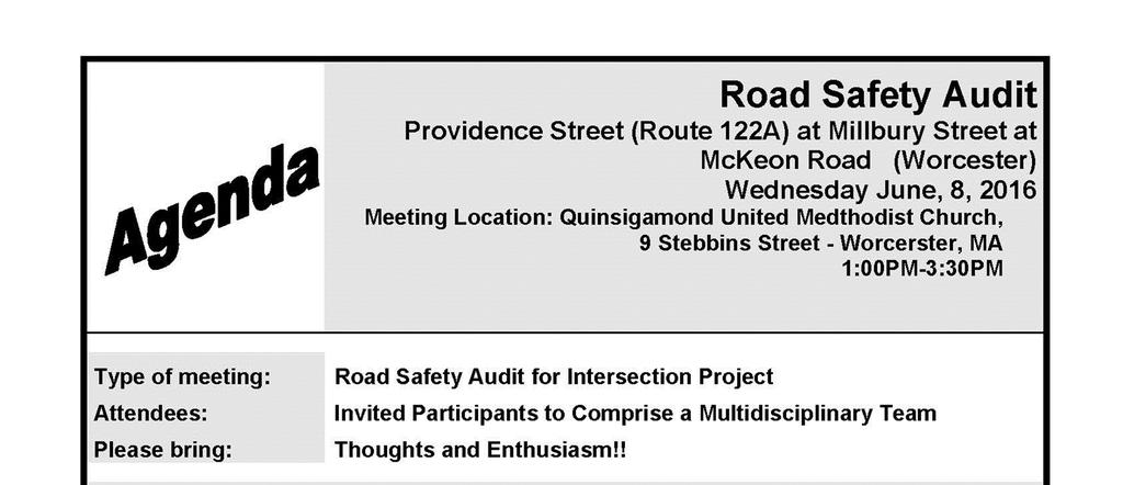
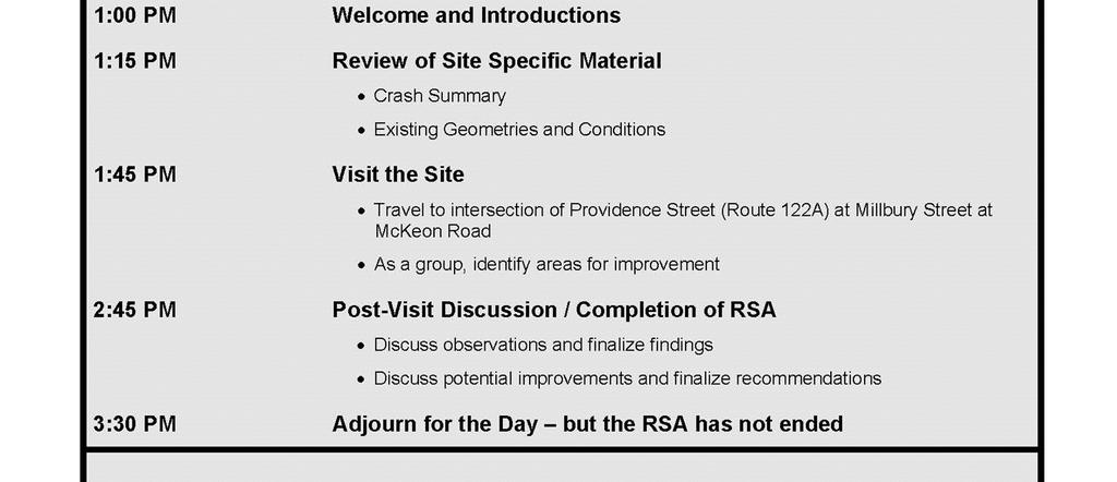
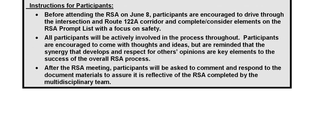
3 Background Stantec of Burlington, Massachusetts has an on-call contract with MassDOT and as part of the Way Forward Signal Improvement funding mechanism, MassDOT is looking to undertake shortterm (routine maintenance improvements), medium (signal improvements) and long-term improvements at the intersection to better facilitate mobility for vehicles, pedestrians and bicycles while enhancing safety. Phase I of this project is to conduct a road safety audit (RSA) to identify the issues. The second phase of the project will be to design the improvements within the right-of-way that will be constructed by the Massachusetts Department of Transportation Highway Division (MassDOT Project Number ). The subject location is the signalized intersection at Providence Street (Route 122A), Millbury Street and McKeon Road and its approaches in Worcester, Massachusetts. As part of the project design process, the crash history within the project limits was researched. In the recent past ( ), motor vehicle crash clusters at the intersection had been identified by MassDOT as a high crash location within the MassDOT District 3 area, using crash data provided by the Registry of Motor Vehicles (RMV). Based on the MassDOT 2012 Top Crash Locations report, this intersection is listed as #90 out of 200 on the State s list. A Roadway Safety Audit, as defined by the Federal Highway Administration, is a formal safety performance examination of an existing or future road or intersection by an independent audit team. This RSA was conducted prior to the Preliminary Design (25% Design) stage of the intersection in order to incorporate safety-related design features early in the design process. Elements of the RSA will be considered for incorporation into the Project as the design progresses. Project Data The Roadway Safety Audit was conducted on June 8, 2016 at 1:00 PM, with the pre- and postaudit meetings held at Quinsigamond United Methodist Church, located at 9 Stebbins Street, Worcester. As can be seen in Table 1, the Audit Team consisted of a cross-section of State and local engineering, emergency response, planning, institutional and bicycle/walk advocacy professionals that was assembled in conjunction with input from MassDOT s Safety Management Unit and the City of Worcester. Page 1
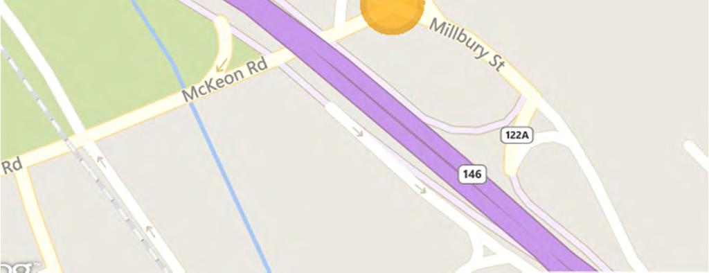
4 Table 1: Participating Audit Team Members Audit Team Member Agency/Affiliation Lori Shattuck MassDOT District 3 Kevin Chiang Karin Valentine-Goins Jerry Powers Sarah Borenstein Douglas Prentiss Michael Lavoie Kevin Krasnecky P.O. Sean Lovely Jackie Ewuoso MassDOT Safety WalkBike Worcester WalkBike Worcester Stantec Stantec City of Worcester Fire Department Central Massachusetts Regional Planning Commission City of Worcester Police Department City of Worcester Division of Public Health Audit participants were provided with materials to review prior to the Audit. The materials included a summary of traffic volume data (daily and peak hour), pedestrian and peak hour data, and a summary of the crash data provided by the Worcester Police Department (including pedestrian and bicycle crashes). Participants were encouraged to visit the site prior to the Audit and were urged to consider elements on MassDOT s Safety Review Prompt List (also provided to Audit participants in advance). The day of the Audit, a pre-audit meeting was held in the recreational hall at Quinsigamond United Methodist Church to discuss the Audit process, review the distributed materials and to discuss the some of the issues that Team members had observed individually, prior to the Audit. The Audit field walk consisted of field observations of the Audit location. Handwritten notes and digital photographs documented the observations made by Audit team members during the field walk. Following the Audit field walk, a post-audit meeting reconvened at Quinsigamond United Methodist Church where the Team confirmed the observations made in the field, identified deficiencies and offered solutions to remedy the safety deficiencies noted in the field walk and Pre-Audit meeting. Project Location and Description The Audit was conducted at the signalized intersection of Providence Street (Route 122A) at Millbury Street and McKeon Road in Worcester, including all approaches to each intersection. A locus map is provided as Figure 1. Page 2


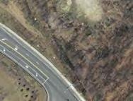

5 Figure 1: Locus Map Page 3
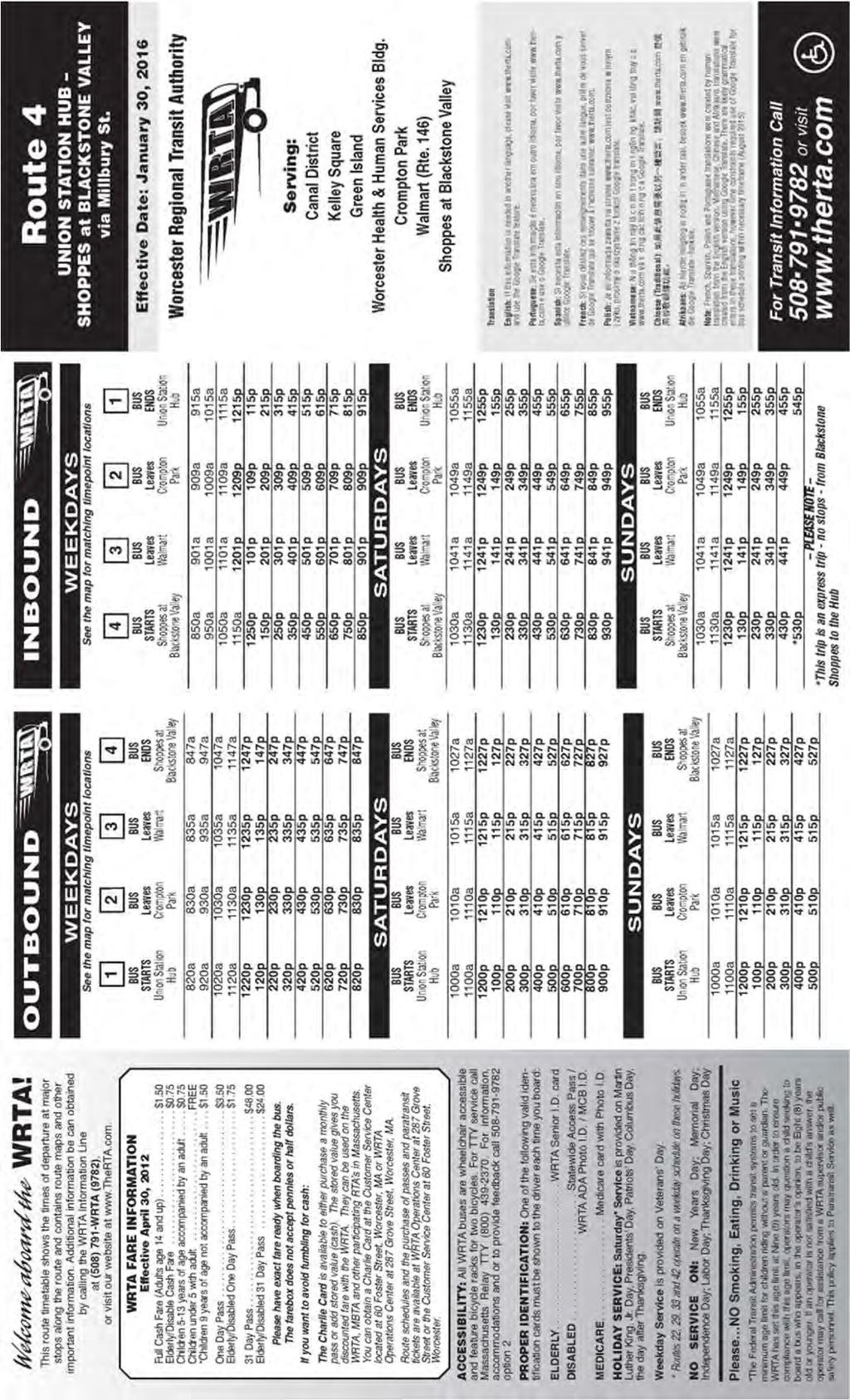
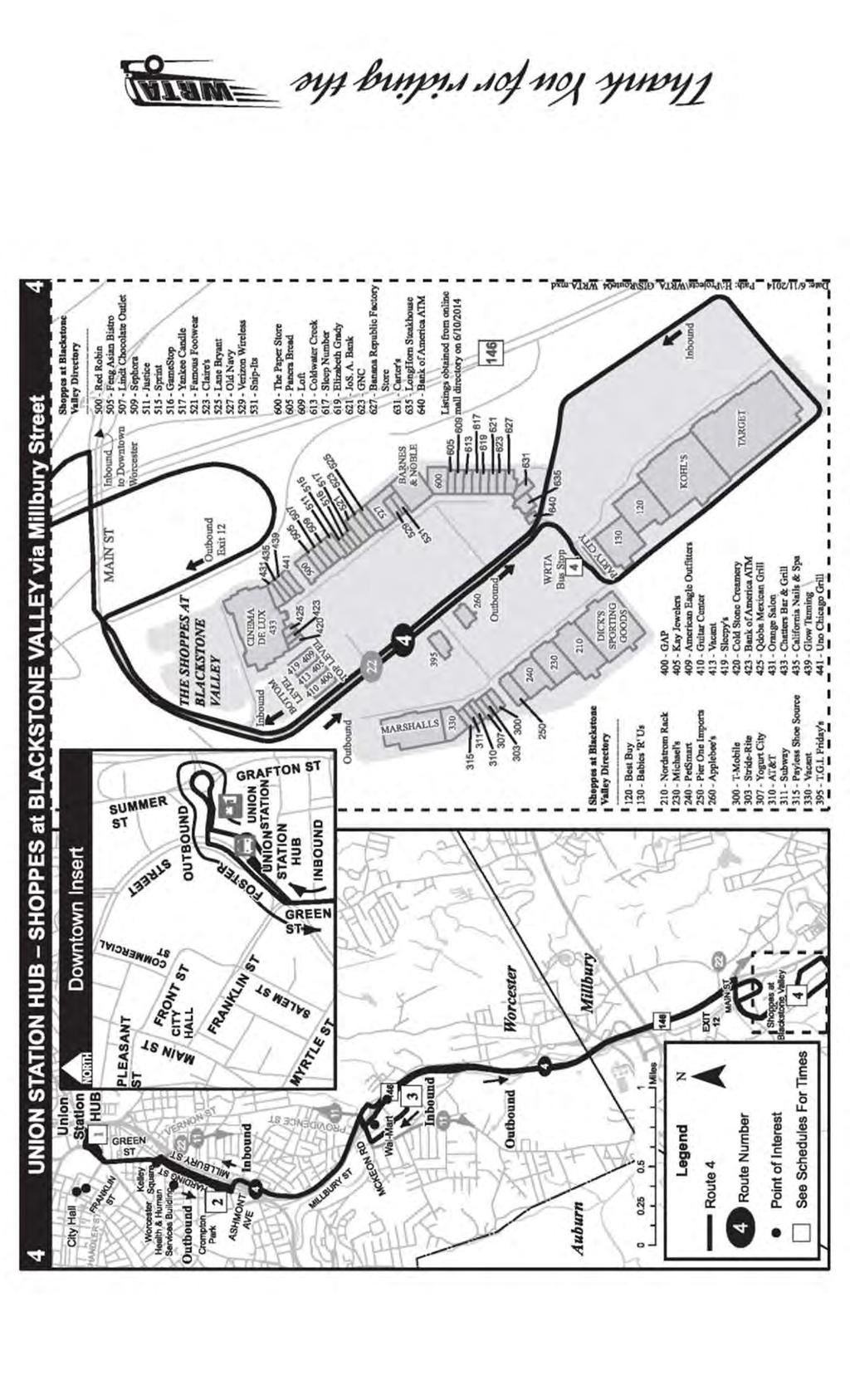
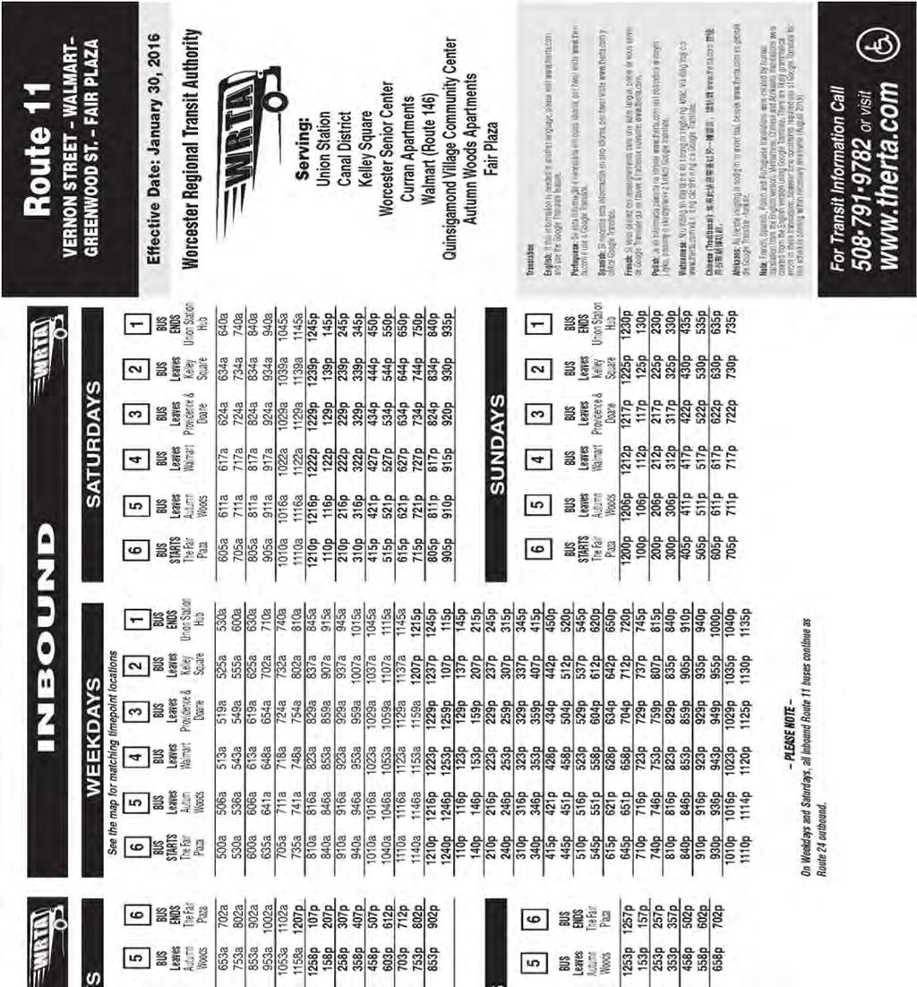
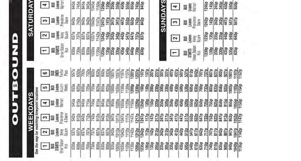
6 Providence Street (Route 122A) at Millbury Street and McKeon Road Providence Street (Route 122A), Millbury Street and McKeon Road are all classified by MassDOT as Urban Minor Arterials. Providence Street (Route 122A) is a vital corridor for north-south travel from the Oak Hill area of the City to points south and connecting to the multilane Route 146 corridor. McKeon Road also serves as an important connection between the College Hill and the Holy Cross area to the Route 146 corridor. Millbury Street serves as a parallel roadway to Route 146 providing connections to the residential neighborhoods and South Worcester and Route 20. The intersection is signalized and is a multi-lane highway-type intersection that leads to Route 146 and I-290. Each approach to the intersection is multi-lane with an exclusive left turn lane provided only on Millbury Street northbound. All roads within the intersection are owned and maintained by MassDOT. It should be noted that Providence Street becomes a city roadway approximately 250 feet north of the intersection and McKeon Road is a city roadway approximately 950 feet west of the intersection. Traffic Volumes Base traffic volumes were collected for this project initially using automatic traffic recorder (ATR) counts for a 48-hour period on all approaches to the intersection. Following analysis of the ATR s for the eight highest hours, turning movement counts (TMC) were completed for those hours and recorded vehicles and pedestrians for the eight-hour period. Additionally, the following traffic data was collected as part of the Project: Location Table 2: Existing 2014 Traffic Volumes AM Peak Hour Daily Volume a Peak Hour Volume b K c Dir. Dist. d Peak Hour Volume PM Peak Hour K Dir. Dist. Millbury Street, west of Providence St 7, % WB % WB Millbury Street, east of Providence St 7, % WB % WB Providence St, north of Millbury St 10, % NB % SB McKeon Road, south of Millbury St 19,923 1, % 1, % NB a b c d daily traffic expressed in vehicles per day peak hour volumes expressed in vehicles per hour percent of daily traffic that occurs during the peak hour directional distribution of peak hour traffic Sidewalks were observed on the south side of McKeon Road along with both sides of Providence Street. There are painted crosswalks across the westbound approach of Millbury Street and the southbound approach at Providence Street. Transit The Worcester Regional Transit authority (WRTA) operates bus Route #4 along Millbury Street from Union Station through the intersection to the Shoppes at Blackstone Valley in the adjacent Town of Millbury. Route #4 runs hourly for a 12-hour period during the day. There are no Page 4
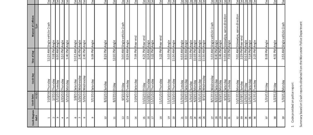
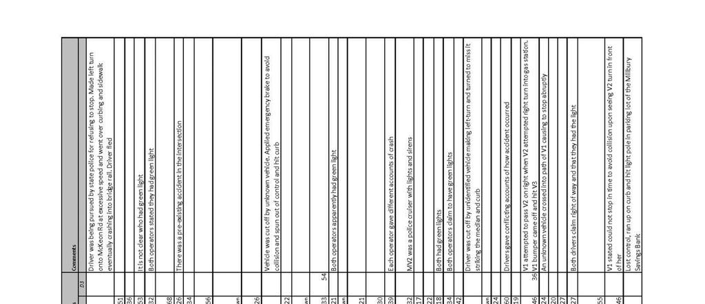
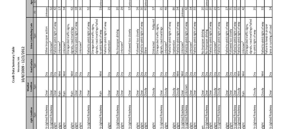
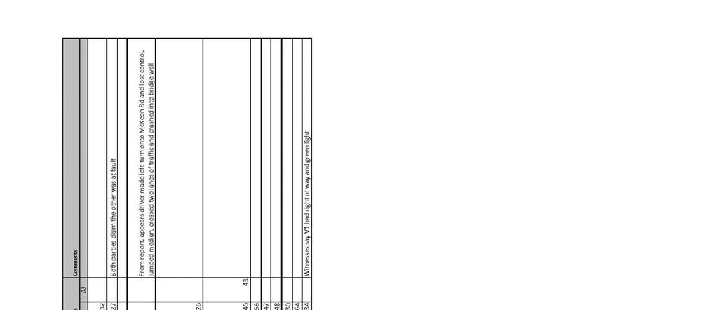
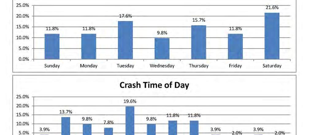
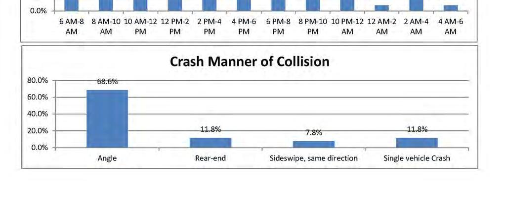
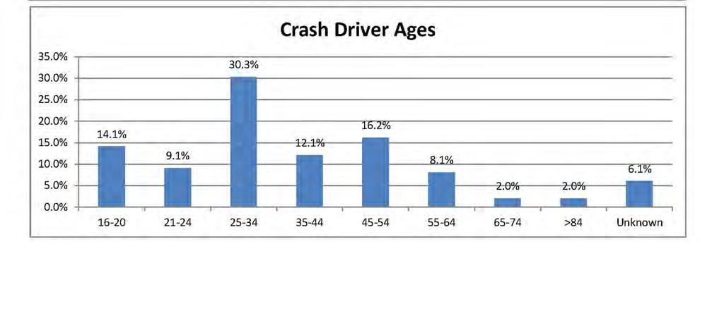
7 designated bus stops in the study area for this route. Bus route #11 also goes through this intersection entering onto Providence Street from Upsala Street with its terminus at Union Station to the Fair Plaza in South Worcester at Route 20. Prior to the intersection on Providence Street, there is a bus stop for Route #11. Crash History A query of MassDOT s online database reveals a high crash cluster for vehicles at the intersection based on crash data. The crash clusters are an indication that the intersection is a high vehicle crash location within the Central Massachusetts Regional Planning Commission (CMRPC) boundaries. The cluster map is contained in Appendix C. In addition, this intersection is listed as #90 on the MassDOT 2012 Top Crash Locations report. It is worth noting that the intersection is not listed in the MassDOT 2013 Top Crash Locations Report. Additionally, individual detailed crash reports for the intersection were provided by the Worcester Police Department for the years 2009 through The individual crash reports typically provide detailed information about the circumstances surrounding a crash and may provide insight into possible causes of crashes. Using the police reports, Stantec was able to prepare a collision diagram for the intersection under evaluation. The collision diagram is included in Appendix C. A total of 51 crashes were identified for the intersection from 2009 to Of those crashes, 14 resulted in an injury, with no fatal injuries. The most common manner of collision was the angle type, which comprised 69% of the identified crashes. Notably, 20% of the identified crashes occurred between the hours of 2PM-4PM which is around when school is released. One of the identified crashes involved a pedestrian. Page 5


8 Audit Observations Audit Team members were solicited for their observations during the Pre-Audit and Post-Audit meetings and during the Audit field walk. The Audit team members offered the following observations on roadway and intersection issues as they relate to safety. Pavement Markings and Signs Within the study area, pavement markings are worn, making the location of the white lane line unclear and consequently, potentially more difficult for vehicles to stay within the travel lane. It was also difficult to see the dotted white lanes lines in the middle of the intersection (sometimes referred to as phantom lines or vehicle tracking lines) that guide vehicles through the turning movement. Although no crashes appeared to be specifically caused by worn pavement markings, worn pavement markings can be a safety issue as pavement markings provide visual cues to drivers so that drivers can make appropriate driving decisions; Example of worn pavement markings It was noted during the site visit that some signs were missing after being struck as the broken sign post is still sticking out of the sidewalk. It may have been the result of the sign being placed too close to the edge of the sidewalk. Not only is this a problem for drivers who no longer see the sign, but a safety issue for a pedestrian who may trip on the broken sign post; Evidence of broken sign post Page 6


9 It was observed during the site visit that there are no exclusive left-turn lanes at the intersection except for the Millbury Street westbound approach. The intersection lacks left-turn arrow pavement markings and signs designating which lane turns left. This would prevent vehicles that are traveling through the intersection getting stuck behind a left-turning vehicle. While this could have been a contributing factor to some crashes, no crashes in the crash history could be directly attributed to this issue; There are no crosswalks for pedestrian travel on the south and west legs of the signalized intersection, yet there are sidewalks present on at least one side of both of those approaches. Crosswalks are present across Providence Road and Millbury Street westbound. The crash history at the intersection shows that there was a crash involving a pedestrian who was trying to cross the Millbury Street eastbound approach; An RSA team member noted that there is a lack of advanced signing for Route 146 traveling northbound on McKeon Street. There is a sign at the previous intersection but only directing to travel straight. The sign at the Millbury Street intersection then directs drivers to turn right. Drivers unfamiliar to the area have no advanced signage to tell them which lane to be in which could cause motorists to change lanes abruptly. There were no crashes in the crash history that could be directly attributed to this issue, but nonetheless, this could be a safety issue. Advanced signage for Rte 146 at previous intersection Signage for Rte 146 at McKeon Rd approach Page 7

10 Traffic Signals Equipment, Timing & Operations At the signalized intersection, the traffic signals are span wire-mounted and not mounted overhead on mast arms. Current MassDOT policy prefers not to use span wires. The current span wire is threaded through overhanging utility wires parallel to the roadway and with high winds the un-insulated utility wires could short-circuit the system. In addition, traffic signal heads that are mounted on span wires tend to sway in heavy winds and could cause visibility issues or become disconnected if not properly secured; Evidence of span wire-mounted traffic signals At the signalized intersection, all of the signal heads lack yellow reflectorized tape on the backplates. The reflective tape has the effect of enhancing the visibility of a signal to road users, since it provides a bright yellow contrasting background to a signal head back plate. The majority of the crashes occurred during the daylight hours, where yellow reflective tape is more effective in providing a contrasting background for the signal backplates; At the signalized intersection, the clearance intervals at the intersection should be reevaluated to ensure that the clearance intervals comply with accepted practices, as the crash history at the intersection suggests that vehicles may not be clearing the intersection before conflicting traffic is assigned the right-of-way. Based on the travel speed, yellow clearance intervals that are too short may not provide enough time for vehicles to stop before entering the intersection. Red clearance intervals that are too short may not provide vehicles enough time to clear the intersection before conflicting traffic is assigned the right-of-way. It is possible that inadequate clearance intervals could result in vehicles entering the intersection on a red signal, as inadequate red or yellow clearance intervals could lead to vehicles being in an intersection as conflicting traffic is given the right-of-way by the traffic signal; At the intersection, there are no pedestrian signal heads on the Millbury Street westbound and the McKeon Road approaches. This makes a dangerous situation for pedestrians traveling southbound on the west side of Providence Street. The crash history at the intersection shows that there was a crash involving a pedestrian who was trying to cross the Millbury Street eastbound approach. Note that the traffic signal includes an exclusive pedestrian phase that allows for pedestrians to cross all crosswalks, while all vehicle Page 8

11 traffic is stopped on all approaches. It is also worth noting that the signal lacks countdown pedestrian signal heads which have been proven to enhance pedestrian safety; It was noted that the signal lacks protected left-turn signal phases along with protected left-turn signal heads. This requires that vehicles who want to turn left are required to wait for all on-coming traffic to clear. There were a considerable number of crashes that involved left-turning traffic and not yielding to the right-of-way of the through traffic. At the signalized intersection, the coordination at the intersection should be investigated to ensure timing is accurate, as traffic can back up south of the intersection and block the previous intersection. An RSA team member had a copy of the signal permit, and it showed the coordination data to confirm the intersection was coordinated. Coordinated intersections that do not have the correct offsets do not allow for traffic to clear at the first intersection so there is sufficient space for traffic at the second intersection to enter without blocking side street traffic. Pedestrian, Bicycle Facilities & Transit Wheelchair ramps were observed at each end of each crosswalk across the intersection. However, some ramps did not appear to be compliant with current accessibility standards (including standards for detectable warning panels, grades, level landings). In general, substandard wheelchair ramps make it more difficult for pedestrians to easily and safely transition between the roadway and the sidewalk and could be a safety issue. However, there were no crashes in the crash history that could be directly attributed to wheelchair ramp compliance; Wheelchair ramp at intersection without detectable warning panel RSA Team members also noted the inconsistency of the bicycle accommodations at the intersection. There is a 6-foot bike lane on the McKeon Road approach that continues eastbound on Millbury Street; however, there are no bike accommodations that continue north on Providence Street. Additionally, there are wide travel lanes and no defined area on the roadway for bicyclists to travel within. Although there were no crashes in the crash history involving bicycles, this can be a safety issue; Page 9
12 At the intersection, debris from accidents and trash from motorists could be seen in the bike lanes. This can create a dangerous situation for bicyclists who must maneuver around the debris to safely cross the intersection; Sidewalks were observed only on the south side of McKeon Road. There is however, a sidewalk on both sides of Providence Street. This makes it inconvenient for pedestrians traveling southbound on the west side of Providence Street. Pedestrians are required to cross Providence Street and then Millbury Street to continue on McKeon Road. Obstructions At the intersection, sightlines for vehicles traveling south on Providence Street may be obstructed by the horizontal curve in the road to the north of the intersection and by the overgrown vegetation growing over embankment. The southbound movement also approaches from a downward slope. The inability to see the traffic signal could result in an increase in the probability of crashes, as vehicles would not have a chance to see the vehicle turning left in front of them; Pavement & Geometry It was noted that the intersection is very wide and open and with long crosswalks for pedestrians to traverse. The corners of the intersection have very large curves that allow drivers to turn at faster speeds. In general, wide radii encourage faster speeds but do not allow enough time to stop if traffic ahead of them has stopped. An RSA team member noted the skewed angle of the intersection. Skewed intersections occur when streets intersect at angles other than 90 degrees and can create complicated scenarios for pedestrians, bicyclists and motorists. They result in longer crossing distances for pedestrians, restrict sight line visibility and facilitate higher speed turning movements by vehicles. Overall An RSA team member noted that the new visitor center was being constructed to the west of the intersection. This new construction would bring considerable more traffic through the intersection including bicycles and pedestrians. Page 10
13 Potential Safety Enhancements The Audit team members offered potential safety enhancements that could be implemented to mitigate the safety related observations that were noted in the previous section of this report. Audit team members were encouraged to develop short, medium and long term safety enhancements. Pavement Markings and Signs As the pavement markings are worn, consider re-applying the pavement markings at the intersection so that they will be more visible to all roadway users. Although no crashes appeared to be specifically caused by worn pavement markings, worn pavement markings can be a safety issue since markings provide guidance and visual cues to drivers; Remove the broken sign posts and relocate the newly installed signs further from the edge of curb. The signs should be positioned so as they are not to be hit by vehicles yet still be visible to motorists. This measure would increase the safety of pedestrians walking on the sidewalk and prevent future collisions with vehicles; Consider applying pavement markings and installing signs to delineate exclusive left-turn lanes. This would prevent drivers who are wishing to travel through the intersection getting stuck behind left-turning traffic who then might change lanes abruptly. This measure would reduce crashes that have occurred between a vehicle traveling straight and another vehicle to the left that would sideswipe the car to the right. This modification would also be compatible with the installation of protected left-turn phases; In order to reduce the likelihood of crashes involving pedestrians at the intersection, consider installing crosswalks across the northbound and eastbound approaches. There are currently crosswalks that cross Providence Road and the east leg of Millbury Street, but are lacking across McKeon Road and the west leg of Millbury Street. This is a safety issue, although there were no pedestrian-vehicle crashes at this location noted in the crash history; Consider installing advanced signage to Route 146 to the south of the intersection to notify motorists traveling northbound to turn right onto Millbury Street eastbound. This measure may allow drivers to change lanes before they reach the signal and prevent changing lanes abruptly. While there were no crashes in the crash history that could be directly attributed to this issue, advanced signage would better inform motorists and improve overall safety. Traffic Signals Equipment, Timing & Operations At the signalized intersection, consider reconstructing the signal systems at the intersection to provide overhead mast arm mounted traffic signals, as currently all traffic signals are span-wire mounted. Overhead mast arm mounted signals are generally more Page 11

14 visible to road users as overhead signals are more closely aligned to the driver s line of sight and, as a result, may increase the likelihood that drivers can see and comply with the right-of-way assigned by the traffic signal. Increasing the visibility of the signal installation may also result in fewer rear-end type crashes, as the traffic signal installation will be more prominent from a greater distance; Consider adding yellow reflectorized tape on the backplates of all traffic signal heads to enhance the visibility of the signals heads. Enhancing the visibility of the signal heads could result in fewer vehicles entering the intersection on a red signal, which has historically resulted in angle and head-on crashes; Example of back plate with retro reflective border At the signalized intersection, consider re-evaluating the clearance intervals at the intersection to ensure that the clearance intervals comply with accepted practices. Proper clearance intervals may result in fewer vehicles entering the intersection on a red signal, which has historically resulted in angle and head-on crashes; At the signalized intersection, consider the installation of pedestrian signal heads for the south and west legs of the intersection so that the assignment of the right of way by the traffic signal to the pedestrian is clear and eliminates the potential for confusion by pedestrians regarding when pedestrians are permitted to cross these legs. These legs of the intersection currently do not have a corresponding pair of pedestrian signal heads. Also consider installing countdown pedestrian signal heads at the intersection. Countdown signals have been known to reduce the proportion of pedestrians running when the flashing Don t Walk signal appears, therefore reducing the number of times that Page 12


15 pedestrians remained in the crosswalk when the signal turned green. FHWA has found that countdown signals reduce all crashes by 25%. Consider the installation of the protected or protected/permissive left-turn signal heads and phases at the intersection. With the number of crashes from left-turning vehicles not yielding to through traffic so high, exclusive phasing would affectively decrease the number of crashes. If protected left-turn signals can t be provided, consider installing flashing yellow arrow signal heads; Protected Left-Turn Traffic Signal Head Flashing Yellow Arrow Traffic Signal Head Evaluate the traffic signal coordination at the intersection and the intersection to the south in its effectiveness to prevent queuing between the two intersections. Recalculate the offsets between the intersections to allow vehicles on McKeon Road to always receive a green signal along the coordinated system. From the signal permit, it was determined that the signal is coordinated with a spread spectrum radio system; Pedestrian, Bicycle Facilities & Transit Consider the evaluation of all wheelchair ramps at the intersections for standards compliance and consider the installation, where required, of wheelchair ramps with detectable warning panels at the ends of all crosswalks. New ramps shall be compliant with the requirements of the Massachusetts Architectural Access Board (MAAB) and Americans with Disabilities Act (ADA). There were no crashes in the crash history that could be directly attributed to wheelchair ramp compliance, however, new ramps provide for easy and safe transition between the roadway and the sidewalk; Consider providing dedicated bicycle lanes on all legs of the intersection so that space on the roadway is specifically allocated to bicycle travel. There is an existing 6-foot bike lane on the McKeon Road approach that continues eastbound on Millbury Street; however, there are no bike accommodations that continue north on Providence Street. While there were no crashes in the crash history involving bicycles, dedicated bicycle lanes may increase safety for bicyclists, and may result in a lower probability of crashes involving bicycles, as space on the roadway is assigned for their use, as opposed to sharing the travel lane with motor vehicles; Page 13

16 Generally, in order to reduce the likelihood of debris from crashes ending up in the bike lane, the City of Worcester should consider a routine maintenance practice of clearing debris following property accidents; Consider constructing a sidewalk on the north side of McKeon Road. Pedestrians who are traveling on Providence Road cannot continue crossing the intersection. An extension of the existing sidewalk would greatly increase pedestrian safety, although there were no pedestrian-vehicle crashes as a result of the lack of sidewalk; Obstructions At the intersection, consider measures to increase the sightline for vehicles traveling southbound on Providence Street, as the sightline is obstructed by the horizontal and vertical curve in the road. Consider trimming vegetation on the west side of Providence Street to increase sight distance for the traffic signal. The additional visibility will also give drivers greater opportunities to see a vehicle stopped at a red light or to see a vehicle turning left in front of them. One measure could be to install a sign in advance of the intersection and interconnected that when the sign turns red, notes: Red Signal Ahead ; Vegetation that is recommended for trimming to improve sightlines Pavement & Geometry Consider altering the geometry by tightening up the intersection. It was suggested that the intersection can be modified to reduce pavement width, reducing the length of pedestrian crossings. This can be accomplished by a combination of reduced lane widths and bump outs. Smaller radii can improve pedestrian safety by requiring motorists to reduce vehicle speed by making sharper turns, and shortening pedestrian crossing distances which thereby improves signal timing. Also the smaller radii provide larger pedestrian waiting areas at corners, improve sign distances, and allow for greater flexibility of curb ramp placement; Consider the evaluation of improving the skewed angle of the intersection. Strategies for improving pedestrian safety at skewed intersection crossings include providing high Page 14
17 Overall visibility marked crosswalks and adding medians or channelization islands to reduce crossing distances. It may be possible to reconfigure the intersection by straightening the skewed approach thereby reducing the speed of turning vehicles by creating a tighter turning radius, and reducing the crossing distance for pedestrians. It should be noted that the McKeon Road approach is fixed as it crosses over Route 146; As there is expected to be an increase in pedestrian and bicycle volumes due to the construction of the visitor center to the west of the intersection, ensure that any proposed changes to McKeon Road account for increases in pedestrian and bicycle activity. This should generally result in improved safety for all types of mobility. Page 15
18 Summary of Road Safety Audit After the site visit, the RSA participants returned to discuss the safety issues and consider various improvements. The participants were encouraged to consider both short and long-term improvements for each of the existing safety issues. Each improvement considered has been categorized as short-term, mid-term, or long-term based on the definitions shown in Table 3. Additionally, a cost category has been assigned to each improvement based on the parameters set forth in Table 3. Table 3: Estimated Time Frame and Costs Breakdown Time Frame Short-Term <1 Year Mid-Term 1-3 Years Long-Term >3 Years Costs Low <$10,000 Medium $10,001-$50,000 High >$50,000 For each safety enhancement noted in the previous section, the following table is a summary of the proposed enhancement, its potential safety payoff, the estimated time frame for completion, the estimated construction cost, and the responsible agency. For enhancements that are expected to be considered and/or incorporated into the improvements of the Way Forward Project (607757), the responsible agency will be listed as Project. These improvements would be funded by MassDOT. The Project infrastructure and construction is under the jurisdiction of MassDOT. The Project is currently set for the fiscal year of Page 16
19 Table 4: Potential Safety Enhancement Summary Safety Issue Potential Safety Enhancement Safety Payoff Time Frame Pavement Markings & Signs Pavement Markings & Signs Pavement Markings & Signs Pavement Markings & Signs Pavement Markings & Signs Traffic Signals Equipment, Timing & Operations Traffic Signals Equipment, Timing & Operations Traffic Signals Equipment, Timing & Operations Traffic Signals Equipment, Timing & Operations Consider reapplying pavement markings Remove broken sign posts & install new signs Consider applying pavement markings and installing signs to delineate exclusive left-turn lanes Consider installing crosswalks across northbound and eastbound approaches Consider installing advanced signage to Route 146 Consider reconstructing the signal systems to provide overhead mast arms mounted traffic signals Consider adding yellow reflectorized tape on backplates Consider evaluating the clearance intervals Consider the installation of pedestrian signal heads for the south and west legs of the intersection and upgrading to countdown pedestrian signal heads Medium Medium High Medium Low Medium Medium Low High Cost Short-Term Low Short-Term Low Mid-Term Low Long-Term High Short-Term Low Long-Term High Short-Term Low Short-Term Low Mid-Term Medium Responsible Agency DOT DOT Project/DOT Project DOT Project DOT DOT Project Traffic Signals Equipment, Timing & Operations Consider providing protected or protected/permissive left-turn signal heads and phases to proceed without any other conflicting movements Medium Long-Term Medium Project Page 17
20 Safety Issue Potential Safety Enhancement Safety Payoff Time Frame Cost Responsible Agency Traffic Signals Equipment, Timing & Operations Pedestrian, Bicycle Facilities & Transit Pedestrian, Bicycle Facilities & Transit Pedestrian, Bicycle Facilities & Transit Pedestrian, Bicycle Facilities & Transit Obstructions Evaluate the traffic signal coordination in its effectiveness to prevent queuing Consider evaluating all wheelchair ramps at the intersection for standards compliance and reconstruct, where necessary, wheelchair ramps to meet current ADA/MAAB design standards Consider providing dedicated bicycle lanes on all legs of the intersection Consider constructing a sidewalk on the north side of McKeon Road Consider an awareness program to prevent debris being pushed into the bicycle lanes Consider measures to increase the sightline for vehicles traveling southbound on Providence Street. Consider trimming vegetation on west side street Low Short-Term Low DOT Medium Long-Term High Project Medium Long-Term Medium Project High Long-Term High Project Low Mid-Term Low City of Worcester High Short-Term Low Project Pavement & Geometry Consider tightening up the intersection. This improvements includes determining the appropriateness of improvements to reduce pavement width, and the subsequent application of those improvements High Long-Term High Project Page 18
21 Safety Issue Potential Safety Enhancement Safety Payoff Time Frame Cost Responsible Agency Pavement & Geometry Overall Consider the evaluation of improving the skewed angle of the intersection. Possible strategies for improving pedestrian safety include providing high visibility marked crosswalks and adding medians or channelization islands to reduce crossing distances Ensure that accommodations at the intersection account for the expected increases in pedestrian and bicycle activity associated with proposed visitor center High Long-Term High Project Medium Mid-Term High Project Page 19
22 Appendix A. RSA Meeting Agenda
23
24 Appendix B. RSA Audit Team Contact List
25 Date: June 8, 2016 Participating Audit Team Members Location: Worcester, MA Audit Team Members Agency/Affiliation Address Phone Number Lori Shattuck MassDOT District 3 Lori.Shattuck@dot.state.ma.us Kevin Chiang MassDOT District 3 Kevin.chiang@state.ma.us Karin Valentine-Goins WalkBike Worcester kvgoins@charter.net Jerry Powers WalkBike Worcester Gerald.powers@charter.net Sarah Borenstein Stantec Sarah.Borenstein@stantec.com Douglas Prentiss Stantec Douglas.Prentiss@stantec.com Michael Lavoie Worcester Fire Department lavoiem@worcesterma.gov Kevin Krasnecky CMPRC KKrasnecky@cmprc.org P.O. Sean Lovely Worcester Police Department lovelysm@worcesterma.gov Jackie Ewuoso Worcester DPH ewuosoj@worcesterma.gov
26 Appendix C. Detailed Crash Data
27
28

29
30
31
32
33 Appendix D. Additional Information
34
35
36
37
ROAD SAFETY AUDIT. State Road (Route 6) Corridor Town of Dartmouth. March Prepared For: MassDOT
 Corridor Town of Dartmouth. March Prepared For: MassDOT") ROAD SAFETY AUDIT State Road (Route 6) Corridor Town of Dartmouth March 2015 Prepared For: MassDOT Prepared By: McMahon Associates, Inc. 300 Myles Standish Blvd. Suite 201 Taunton, MA 02780 Table of Contents
ROAD SAFETY AUDIT State Road (Route 6) Corridor Town of Dartmouth March 2015 Prepared For: MassDOT Prepared By: McMahon Associates, Inc. 300 Myles Standish Blvd. Suite 201 Taunton, MA 02780 Table of Contents
ROAD SAFETY AUDIT. Blue Hill Avenue (Route 28) and Warren Street High Crash Locations City of Boston. November 1, 2016
 and Warren Street High Crash Locations City of Boston. November 1, 2016") ROAD SAFETY AUDIT Blue Hill Avenue (Route 28) and Warren Street High Crash Locations City of Boston November 1, 2016 Prepared For: MassDOT Highway Division Prepared By: BETA Group, Inc. Table of Contents
ROAD SAFETY AUDIT Blue Hill Avenue (Route 28) and Warren Street High Crash Locations City of Boston November 1, 2016 Prepared For: MassDOT Highway Division Prepared By: BETA Group, Inc. Table of Contents
ROAD SAFETY AUDIT. Granite Avenue at Interstate 93 Ramps. Town of Milton. May 22, Prepared for: MassDOT
 ROAD SAFETY AUDIT Granite Avenue at Interstate 93 Ramps Town of Milton May 22, 2017 Prepared for: MassDOT Prepared by: Toole Design Group 2 Oliver Street, Suite 305 Boston, MA 02109 Table of Contents Background...
ROAD SAFETY AUDIT. Centre Street (Route 123) at Plymouth Street. Municipality of Brockton. November, Prepared For: MassDOT
 at Plymouth Street. Municipality of Brockton. November, Prepared For: MassDOT") ROAD SAFETY AUDIT Centre Street (Route 123) at Plymouth Street Municipality of Brockton November, 2017 Prepared For: MassDOT On Behalf Of: City of Brockton Prepared By: Old Colony Planning Council 70 School
ROAD SAFETY AUDIT Centre Street (Route 123) at Plymouth Street Municipality of Brockton November, 2017 Prepared For: MassDOT On Behalf Of: City of Brockton Prepared By: Old Colony Planning Council 70 School
ROAD SAFETY AUDIT. Route 38 from Route 62 to Woburn Town Line. Town of Wilmington. April 10, Prepared For: MassDOT
 ROAD SAFETY AUDIT Route 38 from Route 62 to Woburn Town Line Town of Wilmington April 10, 2017 Prepared For: MassDOT Prepared By: Green International Affiliates, Inc. 239 Littleton Road, Suite 3, Westford,
ROAD SAFETY AUDIT. Route 114 at Interstate I-495 Northbound Ramps. City of Lawrence. July 30, 2015
 ROAD SAFETY AUDIT Route 114 at Interstate I-495 Northbound Ramps City of Lawrence July 30, 2015 Prepared For: Massachusetts Department of Transportation Prepared By: Toole Design Group 33 Broad Street,
FLORIDA DEPARTMENT OF TRANSPORTATION DISTRICT 7 DISTRICT WIDE BICYCLE/PEDESTRIAN ACCESS TO TRANSIT SAFETY ASSESSMENT AND IMPROVEMENT PLAN
 FLORIDA DEPARTMENT OF TRANSPORTATION DISTRICT 7 DISTRICT WIDE BICYCLE/PEDESTRIAN ACCESS TO TRANSIT SAFETY ASSESSMENT AND IMPROVEMENT PLAN TRANSIT SAFETY ASSESSMENT SR 55/US 19 AT 80 TH AVE N DRAFT JUNE
sm1 CDMth '}lf!j1i!~~!2q[ ROAD SAFETY AUDIT County Street City of New Bedford March 22, 2017 Prepared For: MassDOT
 ROAD SAFETY AUDIT County Street City of New Bedford March 22, 2017 '}lf!j1i!~~!2q[ ~ j ighway Divl.sion Prepared For: MassDOT On Behalf Of: City of New Bedford Massachusetts Prepared By: CDM Smith 260
Off-road Trails. Guidance
 Off-road Trails Off-road trails are shared use paths located on an independent alignment that provide two-way travel for people walking, bicycling, and other non-motorized users. Trails specifically along
ROAD SAFETY AUDIT. Route 16 at Interstate 395 Town of Webster. October Prepared For: MassDOT
 ROAD SAFETY AUDIT Route 16 at Interstate 395 Town of Webster October 2015 Prepared For: MassDOT Prepared By: McMahon Associates, Inc. 300 Myles Standish Blvd. Suite 201 Taunton, MA 02780 Table of Contents
ROAD SAFETY AUDIT. County Street at Hart Street. City of Taunton. January 30, Prepared For: Massachusetts Department of Transportation
 ROAD SAFETY AUDIT County Street at Hart Street City of Taunton January 30, 2015 Prepared For: Massachusetts Department of Transportation Prepared By: Toole Design Group 33 Broad Street, 4 th Floor Boston,
Route 28 (South Orleans Road)/Route 39 (Harwich Road)/Quanset Road Intersection
/Route 39 (Harwich Road)/Quanset Road Intersection") TRAFFIC FEASIBILITY STUDY Route 28 (South Orleans Road)/Route 39 (Harwich Road)/Quanset Road Intersection Orleans, Massachusetts Prepared for: Town of Orleans Prepared by: Fay, Spofford & Thorndike, LLC
TRAFFIC FEASIBILITY STUDY Route 28 (South Orleans Road)/Route 39 (Harwich Road)/Quanset Road Intersection Orleans, Massachusetts Prepared for: Town of Orleans Prepared by: Fay, Spofford & Thorndike, LLC
ROAD SAFETY AUDIT. Boston Road (Route 20) at Parker Street and Pasco Road to Dumaine Street City of Springfield Town of Wilbraham.
 at Parker Street and Pasco Road to Dumaine Street City of Springfield Town of Wilbraham.") ROAD SAFETY AUDIT Boston Road (Route 2) at Parker Street and Pasco Road to Dumaine Street City of Springfield Town of Wilbraham October 4, 212 Prepared For: MassDOT Highway Division Prepared By: BETA Group,
ROAD SAFETY AUDIT Boston Road (Route 2) at Parker Street and Pasco Road to Dumaine Street City of Springfield Town of Wilbraham October 4, 212 Prepared For: MassDOT Highway Division Prepared By: BETA Group,
CURBSIDE ACTIVITY DESIGN
 5 CURBSIDE ACTIVITY DESIGN This chapter provides design guidance for separated bike lanes adjacent to curbside activities including parking, loading and bus stops. Typical configurations are presented
AGENDA ITEM 6 D THOMASVILLE ROAD (HERMITAGE BOULEVARD TO LIVE OAK PLANTATION ROAD) ROADWAY SAFETY AUDIT
 ROADWAY SAFETY AUDIT") May 15, 2018 AGENDA ITEM 6 D THOMASVILLE ROAD (HERMITAGE BOULEVARD TO LIVE OAK PLANTATION ROAD) ROADWAY SAFETY AUDIT TYPE OF ITEM: Discussion STATEMENT OF ISSUE The Florida Department of Transportation
May 15, 2018 AGENDA ITEM 6 D THOMASVILLE ROAD (HERMITAGE BOULEVARD TO LIVE OAK PLANTATION ROAD) ROADWAY SAFETY AUDIT TYPE OF ITEM: Discussion STATEMENT OF ISSUE The Florida Department of Transportation
ROAD SAFETY AUDIT. May 18, Prepared For: MassDOT. On Behalf Of: Town of Milford
 ROAD SAFETY AUDIT East Main Street (Route 16) at Medway Road (Route 109), East Main Street (Route 16) at Quarry Square Driveways, East Main Street (Route 16) at Beaver Street/ Fortune Boulevard Town of
Ottawa Beach Road Study
 Ottawa Beach Road Study Prepared For: Park Township September 30, 2014 Project No. G140303 OTTAWA BEACH ROAD STUDY PREPARED FOR: PARK TOWNSHIP SEPTEMBER 30, 2014 PROJECT NO. G140303 TABLE OF CONTENTS 1.0
Appendix C. TRAFFIC CALMING PROGRAM TOOLBOX
 Appendix C. TRAFFIC CALMING PROGRAM TOOLBOX PHASE I...2 Do Not Enter Sign...3 One-Way Sign...4 Turn Prohibition...5 Pavement Markings...6 Speed Monitoring Trailer...7 Neighborhood Speed Watch...8 Police
DEPARTMENT OF ENVIRONMENTAL SERVICES. North Harrison Street (Lee Highway to Little Falls Road) Comparative Analysis. Prepared for:
 Comparative Analysis. Prepared for:") DEPARTMENT OF ENVIRONMENTAL SERVICES North Harrison Street (Lee Highway to Little Falls Road) Comparative Analysis Prepared for: Arlington County Department of Environmental Services 2100 Clarendon Boulevard,
DEPARTMENT OF ENVIRONMENTAL SERVICES North Harrison Street (Lee Highway to Little Falls Road) Comparative Analysis Prepared for: Arlington County Department of Environmental Services 2100 Clarendon Boulevard,
Draft North Industrial Area-Wide Traffic Plan
 Summary of North Industrial and Hudson Bay Industrial Recommended Improvements Table 1. Summary of s Item Location 1 2 3 4 5 6 7 8 9 10 11 12 Millar Ave north of 51st St Super 8 Motel back lane 400 Block
ROAD SAFETY AUDIT. West Central Street (Route 140) at Franklin Village Drive. Town of Franklin. February 03, 2016
 at Franklin Village Drive. Town of Franklin. February 03, 2016") ROAD SAFETY AUDIT West Central Street (Route 140) at Franklin Village Drive Town of Franklin February 03, 2016 Prepared for: Massachusetts Department of Transportation Prepared by: Howard Stein Hudson
ROAD SAFETY AUDIT West Central Street (Route 140) at Franklin Village Drive Town of Franklin February 03, 2016 Prepared for: Massachusetts Department of Transportation Prepared by: Howard Stein Hudson
CITY OF SARATOGA SPRINGS PEDESTRIAN CROSSING TOOLBOX
 CITY OF SARATOGA SPRINGS PEDESTRIAN CROSSING TOOLBOX This toolbox is to be used to guide pedestrian crossing improvements within the City of Saratoga Springs. Details for each crossing type are provided.
ROAD SAFETY AUDIT. Water Street (Route 129) at Vernon Street. Town of Wakefield. September Prepared For: MassDOT
 at Vernon Street. Town of Wakefield. September Prepared For: MassDOT") ROAD SAFETY AUDIT Water Street (Route 129) at Vernon Street September 2017 Prepared For: MassDOT Massachusetts Department of Transportation Prepared By: WorldTech Engineering Road Safety Audit Water Street
ROAD SAFETY AUDIT Water Street (Route 129) at Vernon Street September 2017 Prepared For: MassDOT Massachusetts Department of Transportation Prepared By: WorldTech Engineering Road Safety Audit Water Street
ROAD SAFETY AUDIT. Mass Pike Interchange 6, I-291 and Burnett Road. City of Chicopee. November 4, Prepared For: MassDOT Highway Division
 ROAD SAFETY AUDIT Mass Pike Interchange 6, I-291 and Burnett Road City of Chicopee November 4, 2013 Prepared For: MassDOT Highway Division Prepared By: BETA Group, Inc. Table of Contents Project Data...
ROAD SAFETY AUDIT. Plain Street (Route 139) at Furnace Street and Proprietors Drive Town of Marshfield. June 9, 2017.
 at Furnace Street and Proprietors Drive Town of Marshfield. June 9, 2017.") ROAD SAFETY AUDIT Plain Street (Route 139) at Furnace Street and Proprietors Drive Town of Marshfield June 9, 2017 Prepared for: MassDOT On Behalf of: Vanasse & Associates, Inc. 35 New England Business
ROAD SAFETY AUDIT Plain Street (Route 139) at Furnace Street and Proprietors Drive Town of Marshfield June 9, 2017 Prepared for: MassDOT On Behalf of: Vanasse & Associates, Inc. 35 New England Business
Acknowledgements. Mr. David Nicol 3/23/2012. Daniel Camacho, P.E. Highway Engineer Federal Highway Administration Puerto Rico Division
 Daniel Camacho, P.E. Highway Engineer Federal Highway Administration Puerto Rico Division Acknowledgements Mr. David Nicol Director, FHWA Office of Safety FHWA Office of Safety http://safety.fhwa.dot.gov/provencountermeasures/
Evaluation of M-99 (Broad Street) Road Diet and Intersection Operational Investigation
 Road Diet and Intersection Operational Investigation") Evaluation of M-99 (Broad Street) Road Diet and Intersection Operational Investigation City of Hillsdale, Hillsdale County, Michigan June 16, 2016 Final Report Prepared for City of Hillsdale 97 North Broad
Evaluation of M-99 (Broad Street) Road Diet and Intersection Operational Investigation City of Hillsdale, Hillsdale County, Michigan June 16, 2016 Final Report Prepared for City of Hillsdale 97 North Broad
Toolbox of Countermeasures and Their Potential Effectiveness to Make Intersections Safer
 8 Toolbox of Countermeasures and Their to Make Intersections Safer Introduction Studies included in the NCHRP 17-18 (3), Guidance for Implementation of the AASHTO Strategic Highway Safety Plan, as well
ROAD SAFETY AUDIT. East Main Street (Route 123) at Route I-495 Northbound & Southbound Ramps Town of Norton. May 11, Prepared For: MassDOT
 at Route I-495 Northbound & Southbound Ramps Town of Norton. May 11, Prepared For: MassDOT") ROAD SAFETY AUDIT East Main Street (Route 123) at Route I-495 Northbound & Southbound Ramps Town of Norton May 11, 2016 Prepared For: MassDOT Prepared By: 101 Walnut Street Watertown, MA Road Safety Audit
ROAD SAFETY AUDIT East Main Street (Route 123) at Route I-495 Northbound & Southbound Ramps Town of Norton May 11, 2016 Prepared For: MassDOT Prepared By: 101 Walnut Street Watertown, MA Road Safety Audit
City of Scotts Valley CITY COUNCIL STAFF REPORT
 DATE: April 19, 2017 City of Scotts Valley CITY COUNCIL STAFF REPORT AGENDA ITEM 2 DATE: 4-19-2017 TO: FROM: APPROVED: SUBJECT: Honorable Mayor and City Council Scott Hamby, Public Works Director Jenny
ROAD SAFETY AUDIT. Northampton Road (Route 9) at University Drive and Snell Street Town of Amherst. November 15, Prepared For: MassDOT
 at University Drive and Snell Street Town of Amherst. November 15, Prepared For: MassDOT") ROAD SAFETY AUDIT Northampton Road (Route 9) at University Drive and Snell Street Town of Amherst November 15, 2016 Prepared For: MassDOT Prepared By: Greenman-Pedersen, Inc. 181 Ballardvale Street, Suite
ROAD SAFETY AUDIT Northampton Road (Route 9) at University Drive and Snell Street Town of Amherst November 15, 2016 Prepared For: MassDOT Prepared By: Greenman-Pedersen, Inc. 181 Ballardvale Street, Suite
ROAD SAFETY AUDIT. Route 3A from Evans Street to Abigail Adams State Park. Town of Weymouth. October 12, Prepared For: MassDOT
 ROAD SAFETY AUDIT Route 3A from Evans Street to Abigail Adams State Park Town of Weymouth October 12, 2016 Prepared For: MassDOT Prepared By: Green International Affiliates, Inc. 239 Littleton Road, Suite
Guidance. ATTACHMENT F: Draft Additional Pages for Bicycle Facility Design Toolkit Separated Bike Lanes: Two-Way to One-Way Transitions
 ATTACHMENT F: Draft Additional Pages for Bicycle Facility Design Toolkit Separated Bike Lanes: Two-Way to One-Way Transitions This treatment provides a transition from two-way separated bike lanes to one-way
Meeting Schedule 7:00-7:15 Open House 7:15-7:45 Existing Conditions/Short-Term Improvements Study Presentation 7:45-8:00 Q&A Session 8:00-8:10
 Meeting Schedule 7:00-7:15 Open House 7:15-7:45 Existing Conditions/Short-Term Improvements Study Presentation 7:45-8:00 Q&A Session 8:00-8:10 Long-Term Study Presentation 8:10-8:40 Table Discussions 8:40-9:00
MEMORANDUM. Charlotte Fleetwood, Transportation Planner
 MEMORANDUM Date: Updated August 22, 2017 To: Organization: Charlotte Fleetwood, Transportation Planner Boston Transportation Department From: Jason DeGray, P.E., PTOE, Regional Director of Engineering
Pedestrian Road Safety Audit
 Pedestrian Road Safety Audit Middlebrook Road From Father Hurley Boulevard to Waring Station Road December 2017 Montgomery County Department of Transportation Table of Contents 1. Introduction... 1 1.1
ROAD SAFETY AUDIT. Washington Street (Route 53) at Pleasant Street. Town of Pembroke. June 26, Prepared For: MassDOT Highway Division
 at Pleasant Street. Town of Pembroke. June 26, Prepared For: MassDOT Highway Division") ROAD SAFETY AUDIT Washington Street (Route 53) at Pleasant Street Town of Pembroke June 26, 2014 Prepared For: MassDOT Highway Division Prepared By: BETA Group, Inc. Table of Contents Project Data... 1
ROAD SAFETY AUDIT Washington Street (Route 53) at Pleasant Street Town of Pembroke June 26, 2014 Prepared For: MassDOT Highway Division Prepared By: BETA Group, Inc. Table of Contents Project Data... 1
ROAD SAFETY AUDIT. Route 135 at Route 30 Town of Westborough. January Prepared For: MassDOT
 ROAD SAFETY AUDIT Route 135 at Route 30 January 2016 Prepared For: MassDOT Prepared By: McMahon Associates, Inc. 300 Myles Standish Blvd. Suite 201 Taunton, MA 02780 Road Safety Audit Route 135 at Route
THE FUTURE OF THE TxDOT ROADWAY DESIGN MANUAL
 THE FUTURE OF THE TXDOT ROADWAY DESIGN MANUAL Kenneth Mora, P.E. (Design Division) 10/10/2017 Table of contents 1 2 Reduction in FHWA design controlling criteria Innovative Intersection Guidance 3-7 8-42
TRAFFIC CALMING GUIDE FOR TORONTO CITY OF TORONTO TRANSPORTATION SERVICES DIVISION
 TRAFFIC CALMING GUIDE FOR TORONTO CITY OF TORONTO TRANSPORTATION SERVICES DIVISION CITY OF TORONTO TRANSPORTATION SERVICES DIVISION 2016 TRAFFIC CALMING GUIDE FOR TORONTO TABLE OF CONTENTS Introduction
Broad Street Bicycle Boulevard Design Guidelines
 Broad Street Bicycle Boulevard Design Guidelines Building from the strategies introduced in the 2013 Bicycle Transportation Plan and community input received thus far, City Transportation Staff have identified
MEMORANDUM. DATE March 1, 2012 TO Town of Milton Mark Abbott, Seth Asante, and Efi Pagitsas Boston Region MPO Staff
 MEMORANDUM DATE March 1, 212 TO Town of Milton FROM RE Mark Abbott, Seth Asante, and Efi Pagitsas Boston Region MPO Staff FFY 211 Safety and Operations Analyses at Selected Boston Region MPO Intersections:
Transportation Planning Division
 Transportation Planning Division Presentation Outline Study Tasks Recap of Previous Meetings Data Collected Focus Areas within Study Limits Design Principles Tool Box Recommended Concepts Schedule Moving
10.0 CURB EXTENSIONS GUIDELINE
 10.0 CURB EXTENSIONS GUIDELINE Road Engineering Design Guidelines Version 1.0 March 2017 City of Toronto, Transportation Services City of Toronto Page 0 Background In early 2014, Transportation Services
CHAPTER 16 PEDESTRIAN FACILITIES DESIGN AND TECHNICAL CRITERIA TABLE OF CONTENTS
 CHAPTER 16 PEDESTRIAN FACILITIES DESIGN AND TECHNICAL CRITERIA TABLE OF CONTENTS Section Title Page 16.1 General... 16-1 16.1.1 AASHTO Reference... 16-1 16.1.2 ADA Requirements... 16-1 16.2 Sidewalks...
Active Transportation Facility Glossary
 Active Transportation Facility Glossary This document defines different active transportation facilities and suggests appropriate corridor types. Click on a facility type to jump to its definition. Bike
MEMORANDUM. Date: 9/13/2016. Citywide Crosswalk Policy
 MEMORANDUM Date: 9/13/2016 Re: Citywide Crosswalk Policy Foreword Through the s Circulation Element and Complete Streets Policy, it is the City s goal to promote walking trips and provide safe facilities
Chapter 2: Standards for Access, Non-Motorized, and Transit
 Standards for Access, Non-Motorized, and Transit Chapter 2: Standards for Access, Non-Motorized, and Transit The Washtenaw County Access Management Plan was developed based on the analysis of existing
ROAD SAFETY AUDIT. Route 202 (East State Street)/School Street & Route 202 (West State Street)/Pleasant Street/Amherst Street Town of Granby
/School Street & Route 202 (West State Street)/Pleasant Street/Amherst Street Town of Granby") ROAD SAFETY AUDIT Route 202 (East State Street)/School Street & Route 202 (West State Street)/Pleasant Street/Amherst Street Town of Granby March 2013 Prepared for: Massachusetts Department of Transportation
ROAD SAFETY AUDIT Route 202 (East State Street)/School Street & Route 202 (West State Street)/Pleasant Street/Amherst Street Town of Granby March 2013 Prepared for: Massachusetts Department of Transportation
Date: April 4, Project #: Re: A Street/Binford Street Traffic/Intersection Assessment
 To: Peter Cavanaugh General Electric From: David Bohn, PE Ryan White, PE Date: April 4, 217 Project #: 13421. Re: / Traffic/Intersection Assessment Consistent with the Cooperation Agreement between the
EMPHASIS AREA 1: PEDESTRIANS
 EMPHASIS AREA 1: PEDESTRIANS A pedestrian is seriously injured or killed every 3 days on Toronto s roads. Pedestrian collisions involve any person that is not riding in a vehicle or on a bicycle. 26% OF
ROAD SAFETY AUDIT. Route 1 at Route 123 Route 1 at Route 1A Route 1 at May Street Route 1A and Route 123. City of Attleboro, MA. September 15, 2015
 ROAD SAFETY AUDIT Route 1 at Route 123 Route 1 at Route 1A Route 1 at May Street Route 1A and Route 123 City of Attleboro, MA September 15, 2015 Prepared For: MassDOT On Behalf Of: Prepared By: Fay, Spofford
ROAD SAFETY AUDIT. Route 113 (Storey Avenue) at Woodman Way and Low Street. Newburyport, MA. May 27, Prepared For: MassDOT
 at Woodman Way and Low Street. Newburyport, MA. May 27, Prepared For: MassDOT") ROAD SAFETY AUDIT Route 113 (Storey Avenue) at Woodman Way and Low Street Newburyport, MA May 27, 2015 Prepared For: MassDOT Prepared By: Bayside Engineering, Inc. 600 Unicorn Park Drive Woburn, MA 01801
ROAD SAFETY AUDIT Route 113 (Storey Avenue) at Woodman Way and Low Street Newburyport, MA May 27, 2015 Prepared For: MassDOT Prepared By: Bayside Engineering, Inc. 600 Unicorn Park Drive Woburn, MA 01801
KIETZKE LANE SAFETY MANAGEMENT PLAN FINAL REPORT August, 2013 Submitted By: Parsons. Submitted to:
 KIETZKE LANE SAFETY MANAGEMENT PLAN FINAL REPORT August, 2013 Submitted By: Parsons Submitted to: KIETZKE LANE SAFETY MANAGEMENT PLAN EXECUTIVE SUMMARY The Nevada Department of Transportation (NDOT) has
5. RUNNINGWAY GUIDELINES
 5. RUNNINGWAY GUIDELINES These guidelines should be considered collectively when making runningway decisions. A runningway is the linear component of the transit system that forms the right-of-way reserved
700 Multi-Modal Considerations
 700 Multi-Modal Considerations Table of Contents 701 Railroads... 7-1 701.1 Background... 7-1 701.2 Crossing At-Grade... 7-1 701.2.1 General... 7-1 701.2.2 Railroad Parallel to Highway... 7-1 701.3 Lateral
CITY OF OTTAWA ROADWAY MODIFICATION APPROVAL UNDER DELEGATED AUTHORITY
 RMA-2015-ATM-038 CITY OF OTTAWA ROADWAY MODIFICATION APPROVAL UNDER DELEGATED AUTHORITY DATE: April 22, 2015 SUBJECT Approval of Roadway Modifications Recommended through an Area Traffic Management Study
As the Toronto Transit Commission (TTC) operates a transit service on Avenue Road, City Council approval of this report is required.
 operates a transit service on Avenue Road, City Council approval of this report is required.") REPORT FOR ACTION Corridor Safety Review - Avenue Road Date: September 27, 2017 To: Toronto and East York Community Council From: Acting Director, Transportation Services, Toronto and East York District
REPORT FOR ACTION Corridor Safety Review - Avenue Road Date: September 27, 2017 To: Toronto and East York Community Council From: Acting Director, Transportation Services, Toronto and East York District
2014 FHWA Aging Road User Handbook. Recommendations to Accommodate Aging Pedestrians. Lifesaver National Conference. What is the Handbook?
 2014 FHWA Aging Road User Handbook Recommendations to Accommodate Aging Pedestrians Lifesaver National Conference March 17, 2015 Revised June 2014 1 What is the Handbook? 1998 1st Edition 2001 2nd Edition
Everyone is a Pedestrian
 Everyone is a Pedestrian Improving Pedestrian Safety in Texas Transportation and Trinity River Project Committee 26 May 2015 Everyone is a Pedestrian Federal Highway Administration [ FHWA ] Programs to
MEMORANDUM. Nantasket Road at Kingsley Road Kingsley Road at Sumner Street Kingsley Road at Revere Street Kingsley Road at Kenberma Street
 MEMORANDUM Date: June 28, 2012 To: From: Subject: Mr. Joseph Stigliani, Director of Public Works Kenneth J. Petraglia, P.E., PTOE Greg E. Lucas, P.E., PTOE Kingsley Road Stop Sign Warrant Analysis BETA
ROAD SAFETY AUDIT. Auburn Street at Southbridge Street (Route 12) Town of Auburn. March Prepared For: Massachusetts Department of Transportation
 Town of Auburn. March Prepared For: Massachusetts Department of Transportation") ROAD SAFETY AUDIT Auburn Street at Southbridge Street (Route 12) Town of Auburn March 2017 Prepared For: Massachusetts Department of Transportation Prepared By: Vanasse Hangen Brustlin, Inc Union Station
ROAD SAFETY AUDIT Auburn Street at Southbridge Street (Route 12) Town of Auburn March 2017 Prepared For: Massachusetts Department of Transportation Prepared By: Vanasse Hangen Brustlin, Inc Union Station
Caltrans Sloat Boulevard Pedestrian Safety Project Response to Community Questions, Comments & Concerns
 Caltrans Sloat Boulevard Pedestrian Safety Project Response to Community Questions, Comments & Concerns Revised: May 10, 2016 The California Department of Transportation (Caltrans) is planning various
Cycle Track Design Best Practices Cycle Track Sections
 Design Best Practices Sections It is along street segments where the separation and protection methods of cycle tracks offer more comfort than conventional bicycle lanes, and are more attractive to a wide
Military Road Safety Improvements
 Military Road Safety Improvements 26 th Road North to 31 st Street North SUMMARY OF DATA REVIEW AND PRELIMINARY RECOMMENDATIONS Prepared for: Department of Environmental Services Traffic Engineering and
ROAD SAFETY AUDIT. Santilli Circle and Sweetser Circle. Municipality of Everett. March 10, Prepared For: MassDOT
 ROAD SAFETY AUDIT Santilli Circle and Sweetser Circle Municipality of Everett Prepared For: MassDOT On Behalf Of: WYNN Design and Development Prepared By: AECOM 250 Apollo Drive Chelmsford, MA Road Safety
Multi-Modal Traffic Analysis. Parisi and Associates
 Mill Valley to Corte Madera Bicycle and Pedestrian Corridor Study Appendix D: Multi-Modal Traffic Analysis Prepared by Parisi and Associates August 2009 Appendix D - Multi-Modal Traffic Analysis Table
TRAFFIC IMPACT ANALYSIS
 TRAFFIC IMPACT ANALYSIS FOR THE CHAMPAIGN UNIT#4 SCHOOL DISTRICT PROPOSED HIGH SCHOOL (SPALDING PARK SITE) IN THE CITY OF CHAMPAIGN Final Report Champaign Urbana Urbanized Area Transportation Study 6/24/2014
Truck Turning Study for Main Street Intersection, Orange
 Truck Turning Study for Main Street Intersection, Orange Franklin Regional Council of Governments September 2015 0 Truck Turning Study for Main Street Intersection, Orange September 2015 Prepared by: Franklin
TRAFFIC ACTION PLAN. Laurie Meadows Neighborhood CITY OF SAN MATEO
 TRAFFIC ACTION PLAN Laurie Meadows Neighborhood CITY OF SAN MATEO Draft January 2017 Table of Contents Introduction... 2 The Traffic Forum Process... 5 Neighborhood Traffic Issues... 7 Neighborhood Recommendations
Rank #1 Highest Priority Intersection
 Rank #1 Highest Priority Intersection Attachment 3: Proposed Interventions Pedestrian Safety City of Toronto s 10 Priority Intersections Sheppard Avenue East and Ambrose Road/Provost Drive Located in the
Road Safety Audit for the Intersection of VFW Highway & Bridge Street in Lowell, Massachusetts
 Road Safety Audit for the Intersection of VFW Highway & Bridge Street in Lowell, Massachusetts Prepared by University of Massachusetts Traffic Safety Research Program Prepared for Massachusetts Highway
CTDOT Pedestrian and Bicycle Safety Initiatives
 CTDOT Pedestrian and Bicycle Safety Initiatives 2017 Northeast Transportation Safety Conference Mark F. Carlino, P.E. Traffic Engineering Division Chief Bureau of Engineering and Construction Connecticut
Public Information Centre
 WELCOME Public Information Centre Father Tobin Road Lougheed Middle School - Library Wednesday November 7, 2012 7:00 p.m.to 9:00 p.m. Please sign in Neighbourhood Traffic Calming Guide Background The City
ROAD SAFETY AUDIT. Route 18 (Bedford Street) from Whitman Street to Central Square Town of East Bridgewater. May 14, 2014
 from Whitman Street to Central Square Town of East Bridgewater. May 14, 2014") ROAD SAFETY AUDIT Route 18 (Bedford Street) from Whitman Street to Central Square Town of East Bridgewater May 14, 2014 Prepared For: MassDOT Highway Division Prepared By: BETA Group, Inc. Table of Contents
ROAD SAFETY AUDIT Route 18 (Bedford Street) from Whitman Street to Central Square Town of East Bridgewater May 14, 2014 Prepared For: MassDOT Highway Division Prepared By: BETA Group, Inc. Table of Contents
Appendix A: Crosswalk Policy
 Appendix A: Crosswalk Policy Appendix A: Crosswalk Policy Introduction This citywide Crosswalk Policy is aimed at improving pedestrian safety and enhancing pedestrian mobility by providing a framework
PEDESTRIAN ACCOMMODATIONS DPS 201 AT ROUNDABOUTS
 PEDESTRIAN ACCOMMODATIONS DPS 201 AT ROUNDABOUTS WHY THEY WORK FOR PEDESTRIANS IF DESIGNED CORRECTLY Separated sidewalks direct peds to crosswalks Splitter island Slow speed exit Truck apron Crosswalk
MEMORANDUM. Layout Of Study Intersections And Traffic Control
 BOSTON REGION METROPOLITAN PLANNING ORGANIZATION Richard A. Davey, MassDOT Secretary and CEO and MPO Chairman Karl H. Quackenbush, Executive Director, MPO Staff DATE November 15, 2012 TO FROM RE Town of
BD RESOLUTION NO RESOLUTION ADOPTING THE VISION ZERO RAMP INTERSECTION STUDY PHASE 1
 BD00 RESOLUTION NO. - RESOLUTION ADOPTING THE VISION ZERO RAMP INTERSECTION STUDY PHASE [NTIP PLANNING] FINAL REPORT WHEREAS, The Vision Zero Ramp Intersection Study Phase was recommended by Commissioner
From Mile Zero to Target Zero the Dawson Creek Case Study
 From Mile Zero to Target Zero the Dawson Creek Case Study Raheem Dilgir, President, TranSafe Consulting Ltd. and Kevin Henderson, Manager of Planning and Development, City of Dawson Creek Paper prepared
CHAPTER 1 STANDARD PRACTICES
 CHAPTER 1 STANDARD PRACTICES OBJECTIVES 1) Functions and Limitations 2) Standardization of Application 3) Materials 4) Colors 5) Widths and Patterns of Longitudinal Pavement Marking Lines 6) General Principles
Intersection Traffic Control Feasibility Study
 Intersection Traffic Control Feasibility Study CSAH 9 at CSAH 60 (185th Avenue) Prepared For: Dakota County Transportation Department Western Service Center 14955 Galaxie Avenue, 3rd Floor Apple Valley,
Designing for Pedestrian Safety. Alabama Department of Transportation Pre-Construction Conference May 2016
 Designing for Pedestrian Safety Alabama Department of Transportation Pre-Construction Conference May 2016 1 Designing for Pedestrians Marking Crosswalks at Signalized intersections High Visibility Markings
Pedestrian, Bicycle and Traffic Calming Strategic Implementation Plan. January 18, 2011
 Pedestrian, Bicycle and Traffic Calming Strategic Implementation Plan January 18, 2011 Tonight s Agenda Receive update on project Provide feedback on two policy issues Complete Streets Policy Project Prioritization
Agenda. Overview PRINCE GEORGE S PLAZA METRO AREA PEDESTRIAN PLAN
 PRINCE GEORGE S PLAZA METRO AREA PEDESTRIAN PLAN May 28, 2008 Agenda Welcome and introductions Project overview and issue identification Planning context and strengths Design challenges and initial recommendations
What Is a Complete Street?
 Session 5 Charleen Zimmer, AICP, Zan Associates May 5-7, 2010 What Is a Complete Street? May 2010 5-1 Not a Complete Street More of a Complete Street May 2010 5-2 Benefits of Complete Streets Safety for
ROAD SAFETY AUDIT. Rourke Bridge at Pawtucket Boulevard (Route 113) City of Lowell. October 5, Prepared For: MassDOT.
 City of Lowell. October 5, Prepared For: MassDOT.") ROAD SAFETY AUDIT Rourke Bridge at Pawtucket Boulevard (Route 113) City of Lowell October, 2017 Prepared For: MassDOT Prepared By: Vanasse Hangen Brustlin, Inc 101 Walnut Street Watertown, MA 02472 Road
ROAD SAFETY AUDIT Rourke Bridge at Pawtucket Boulevard (Route 113) City of Lowell October, 2017 Prepared For: MassDOT Prepared By: Vanasse Hangen Brustlin, Inc 101 Walnut Street Watertown, MA 02472 Road
Lake Whitney Elementary School
 Lake Whitney Elementary School SCHOOL ROUTE PLAN For LAKE WHITNEY ELEMENTARY SCHOOL LOCATION 18 ORANGE COUNTY Prepared for: ORANGE COUNTY SCHOOL ASSESSMENT PROGRAM ORANGE COUNTY PUBLIC WORKS Traffic Engineering
Accommodating Pedestrians in the Work Zone
 Accommodating Pedestrians in the Work Zone Guidance for Section C Plan Preparers Some impacts cannot be avoided and those impacts apply to residents, businesses, motorists, and pedestrians alike. However,
ROAD SAFETY AUDIT. Needham Street and Highland Avenue Corridor. City of Newton and Town of Needham. March 2014
 ROAD SAFETY AUDIT Needham Street and Highland Avenue Corridor City of Newton and Town of Needham March 2014 Prepared for: Massachusetts Department of Transportation Prepared by: Howard/Stein-Hudson Associates
ROAD SAFETY AUDIT. Russell Street (Route 9) at North and South Maple Streets Town of Hadley. March 2014
 at North and South Maple Streets Town of Hadley. March 2014") ROAD SAFETY AUDIT Russell Street (Route 9) at North and South Maple Streets Town of Hadley March 2014 Prepared for: Massachusetts Department of Transportation Prepared by: Howard/Stein-Hudson Associates
ROAD SAFETY AUDIT Russell Street (Route 9) at North and South Maple Streets Town of Hadley March 2014 Prepared for: Massachusetts Department of Transportation Prepared by: Howard/Stein-Hudson Associates
Chapter 5 DATA COLLECTION FOR TRANSPORTATION SAFETY STUDIES
 Chapter 5 DATA COLLECTION FOR TRANSPORTATION SAFETY STUDIES 5.1 PURPOSE (1) The purpose of the Traffic Safety Studies chapter is to provide guidance on the data collection requirements for conducting a
ROAD SAFETY AUDIT MDM. Columbia Road at Dorchester Avenue. Dorchester, MA 10/14/2016. Prepared For: MassDOT. On Behalf Of: Edens
 ROAD SAFETY AUDIT Columbia Road at Dorchester Avenue Dorchester, MA 10/14/2016 Prepared For: MassDOT On Behalf Of: Edens Prepared By: MDM Transportation Consultants, Inc. 28 Lord Road Suite 280 Marlborough,
Alternative Traffic Calming Methods
 Alternative Traffic Calming Methods In-street Pedestrian Crossing Sign Cost: approximately $300 per sign not including the installation cost Advantages of in-street pedestrian crossing signs 1. Typically
ROAD SAFETY AUDIT. Route 2/Taylor Road/Piper Road. Town of Acton. March 4, Prepared For: Massachusetts Department of Transportation
 ROAD SAFETY AUDIT Route 2/Taylor Road/Piper Road Town of Acton March 4, 2015 Prepared For: Massachusetts Department of Transportation Prepared By: Tetra Tech, Inc. One Grant Street Framingham, MA 01702
APPENDIX A: Complete Streets Checklist DRAFT NOVEMBER 2016
 APPENDIX A: Complete Streets Checklist DRAFT NOVEMBER 2016 Complete Streets Checklist MetroPlan Orlando s Complete Streets Checklist is an internal planning tool for staff to further implementation of
ADA Transition Plan. City of Gainesville FY19-FY28. Date: November 5, Prepared by: City Of Gainesville Department of Mobility
 ADA Transition Plan FY19-FY28 Date: November 5, 2018 Prepared by: City Of Gainesville Department of Mobility 1.0 INTRODUCTION 1.1 BACKGROUND The federal statute known as the Americans with Disabilities
Access Management in the Vicinity of Intersections
 Access Management in the Vicinity of Intersections FHWA-SA-10-002 Technical Summary Photo: Ralph Bentley (used with permission) 0 Access Management is: The design, implementation and management of entry
CITY OF LOS ANGELES INTER-DEPARTMENTAL MEMORANDUM
 CITY OF LOS ANGELES INTER-DEPARTMENTAL MEMORANDUM Date: April 1, 219 To: Honorable City Council c/o City Clerk, Room 395, City Hall Attention: Honorable Mike Bonin, Chair, Transportation Committee From:
M-58 HIGHWAY ACCESS MANAGEMENT STUDY Mullen Road to Bel-Ray Boulevard. Prepared for CITY OF BELTON. May 2016
 M-58 HIGHWAY ACCESS MANAGEMENT STUDY Prepared for CITY OF BELTON By May 2016 Introduction Missouri State Highway 58 (M-58 Highway) is a major commercial corridor in the City of Belton. As development has