ROAD SAFETY AUDIT. Route 2/Route 68 Interchange Rotary City of Gardner. August 3, Prepared For: MassDOT
|
|
|
- Brandon Richards
- 6 years ago
- Views:
Transcription
1 ROAD SAFETY AUDIT Route 2/Route 68 Interchange Rotary City of Gardner August 3, 2016 Prepared For: MassDOT Prepared By: Tetra Tech 100 Nickerson Avenue Marlborough, MA 01752
2 Road Safety Audit Route 2/Route 68 Interchange Rotary Tetra Tech Table of Contents Contents Background... 1 Project Data... 2 Project Location and Description... 3 Audit Observations and Potential Safety Enhancements... 4 Safety Issue #1 Rear-End Crashes on Rotary Approaches... 4 Safety Issue #2 Signing... 6 Safety Issue #3 Lighting... 7 Safety Issue #4 Pedestrian Accommodations... 7 Safety Issue #5 Bicycle Accommodations... 8 Safety Issue #6 Pavement... 8 Safety Issue #7 External Influences on the Rotary... 9 Summary of Road Safety Audit List of Appendices Appendix A. Appendix B. Appendix C. Appendix D. RSA Meeting Agenda RSA Audit Team Contact List Detailed Crash Data Additional Information List of Figures Figure 1: Locus Map... 1 List of Tables Table 1: Participating Audit Team Members... 2 Table 2: Estimated Time Frame and Costs Breakdown Table 3: Potential Safety Enhancement Summary... 11
.")
3 Road Safety Audit Route 2/Route 68 Interchange Rotary Tetra Tech Background A Road Safety Audit (RSA) was conducted at the Route 2/Route 68 interchange rotary in Gardner (see Figure 1). The interchange is under design by MassDOT (Project #608188). The Road Safety Audit process is a way of evaluating the safety of an intersection using a multidisciplinary team of engineers, administrators and safety personnel to identify issues that may be corrected to improve safety. The team may identify short-term, medium-term, and long-term improvements which can be implemented in the near-term through maintenance or in the medium or long-term through the design process. Figure 1: Locus Map The MassDOT Highway Division obtains crash data from the Massachusetts Registry of Motor Vehicles (RMV) database and uses the data for many purposes. One of the primary purposes is to identify high crash locations at intersections throughout the Commonwealth. The crashes are grouped into clusters based on a crash cluster analysis method developed by their consultant, Geonetics. The information is presented in a GIS format which merges the crashes into clusters based on their location relative to each Page 1
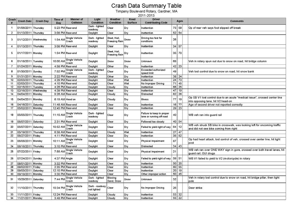
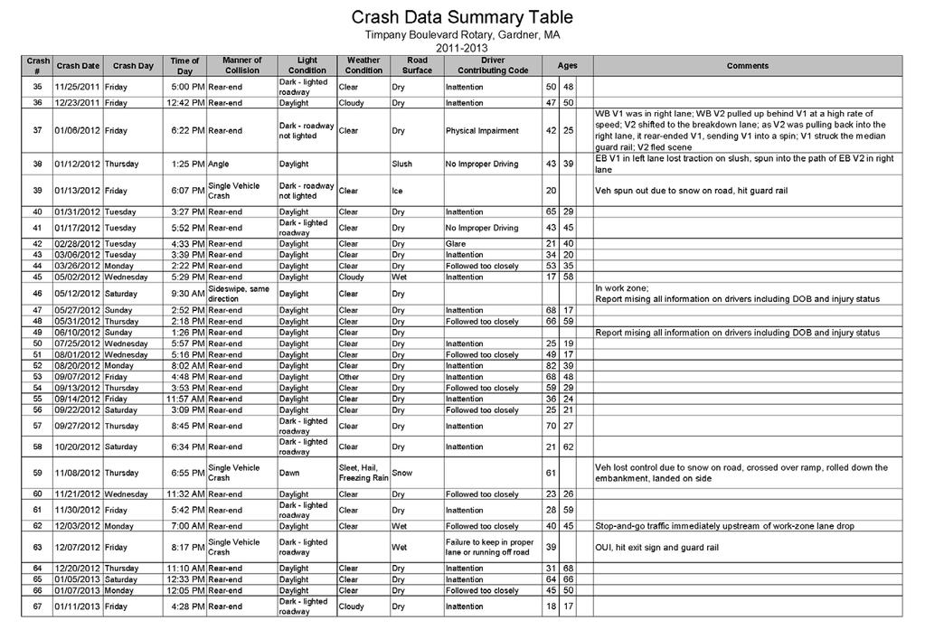
4 Road Safety Audit Route 2/Route 68 Interchange Rotary Tetra Tech other. The software then calculates an Equivalent Property Damage Only (EPDO) rating for all the clusters and ranks them. Based on this analysis methodology, two segments within the rotary have been identified as high crash locations: i) Route 68 (Timpany Boulevard) beginning just south of Donlan Street to the Route 2 westbound on-ramp and ii) Route 68 beginning from its intersection with the southern portion of the rotary to the Route 2 eastbound on-ramp. Based on MassDOT data, the northern high crash location experienced 32 reported crashes between 2011 and 2013 resulting in an EPDO rating of 44. The southern high crash location experienced 16 reported crashes between 2011 and 2013 resulting in an EPDO rating of 36. Project Data The audit was conducted on Wednesday, August 3, The RSA agenda appears in Appendix A. Table 1 lists the audit team participants and their affiliation. The contact information for the audit team members is contained in Appendix B. Data provided to audit team members and reviewed at the RSA included area maps, speed limit regulations and detailed crash information and is contained in Appendices C and D. The crash data and collision diagrams are based on crashes reported by the Gardner Police Department from 2011 to Table 1: Participating Audit Team Members Audit Team Member Agency/Affiliation Lisa Schletzbaum Massachusetts Highway Department Safety Section David Posner Massachusetts Highway Department - Safety Section Adam Prichard Massachusetts Highway Department Safety Section Joshua Bartus Massachusetts Highway Department Highway Design Rohith Prakash Massachusetts Highway Department Highway Design Davidson Borgelorme Massachusetts Highway Department Highway Design Joseph Frawley Massachusetts Highway Department District 3 Traffic Erin Kinahan Massachusetts Highway Department - District 3 Traffic George Snow Montachusett Regional Planning Commission - Principal Transportation Planner Paul M. Capps Massachusetts State Police Lt. Jerry Molet Massachusetts State Police Richard Ares Gardner, Fire Department Chris Coughlin Gardner, Engineering Bob Hankinson Gardner, Engineering David Arnold Gardner, DPW Jeff Legros Gardner, Planning Edward Myers Kittelson & Associates Conor Semler Kittelson & Associates Nancy Doherty Tetra Tech Courtney Jones Tetra Tech Page 2
5 Road Safety Audit Route 2/Route 68 Interchange Rotary Tetra Tech Project Location and Description In Gardner, Route 68 (Timpany Boulevard) and the Route 2 on-ramps and off-ramps form a four-legged rotary which serves as the Route 2/Route 68 interchange. The rotary is located approximately one-half mile south of downtown Gardner and is under MassDOT jurisdiction. The Pan American railroad, which runs parallel to Route 2, crosses over Route 68 approximately 60 feet north of the outer edge of the rotary. Route 2, a principal arterial providing an east-west link across Massachusetts, passes over Route 68 and the rotary. North of the rotary, Route 68 is an urban minor arterial functioning as a north-south link between the rotary and Route 101 and a northwest-southeast link between Route 101 and the City of Gardner boundary with the Town of Templeton. South of the rotary, Route 68 is an urban principal arterial traveling between the rotary and the Gardner boundary with the Town of Hubbardston. Route 68 is under local (City) jurisdiction from the boundary with the Town of Hubbardston to the rotary and between Donlan Street to Monadnock Street. Route 68 provides access to numerous commercial uses including Hannaford Supermarket, Burger King and McDonald s. The Gardner Police Station is also located along Route 68 approximately one-third of a mile north of the rotary. Route 68 generally provides a single travel lane, a marked shoulder and granite curbing in each direction. In the vicinity of the rotary, sidewalk is only located along the east side of Route 68. The speed limit on Route 68 is 30 mph. The rotary has an outer diameter of approximately 460 feet with a wide circulatory road, approximately 40 feet wide. Shoulder markings are present along the inner and outer curb lines, however they have almost entirely faded, and as such, are ineffective. Route 2 approaches from the east and west and Route 68 approaches from the north and south. The Route 2 and Route 68 approaches to the rotary provide a single, channelized right-turn lane operating under Yield control. The distances between the on and off ramps range from approximately 170 feet to 220 feet. Crosswalks are provided within the rotary across the Route eastbound on-ramp and the Route 2 westbound off-ramp. Both crosswalks have pedestrian ramps, but the ramps do not comply with Americans with Disabilities Act and Architectural Access Board (ADA/AAB) standards. Pedestrians wishing to cross Route 68 in a crosswalk must do so at the Route 68/Crawford Street intersection approximately 250 feet south of the rotary entrance. North of the rotary, pedestrians must cross at two crosswalks to get to/from the westerly side of Route 68: i) at the Main Street/Pine Street intersection and ii) at the Route 68/Main Street intersection adjacent to CVS Pharmacy (a walking distance of approximately 0.35 miles). Bicycle accommodations are not provided along Route 68 or through the rotary. Traffic volume count data was not available during the Road Safety Audit. However, participants indicated that the heaviest traffic flows occur in the morning from Route 68 southbound to Route 2 eastbound and in the afternoon from Route 2 westbound to Route 68 northbound. Page 3

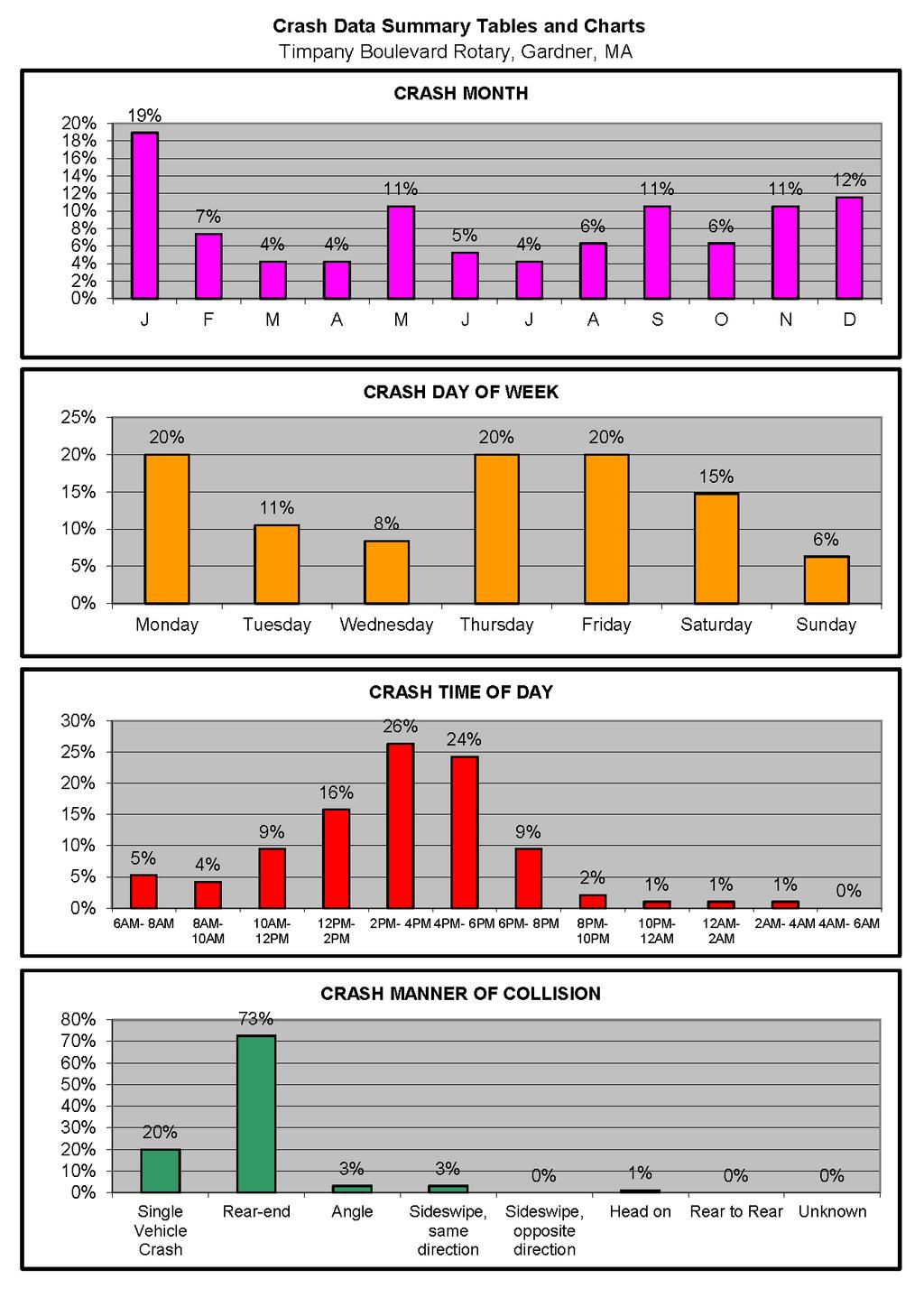
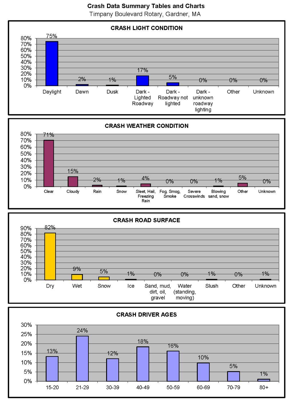
6 Road Safety Audit Route 2/Route 68 Interchange Rotary Tetra Tech Audit Observations and Potential Safety Enhancements The RSA was conducted at Gardner City Hall. In attendance were representatives from MassDOT, Massachusetts State Police, the City of Gardner, Montachusett Regional Planning Commission, Kittelson & Associates and Tetra Tech. The following sections describes each of the safety issues in detail and discusses the potential enhancements and safety improvements developed by the RSA team. Following this section is a summary table outlining the issue, the potential solution, timeframe and responsible agency. Safety Issue #1 Crashes on Rotary Approaches Observations: Of the 95 crashes reported for the three year study period at or near the rotary, 66 rear-end collisions occurred on the four approaches to the rotary (25 on the Route 68 southbound approach, 24 on the Route 68 northbound approach, 12 on the Route 2 westbound off-ramp and 5 on the Route 2 eastbound off-ramp). Driver inattention and following too closely were cited as contributing factors in 83 percent of these crashes. Audit team members cited several possible reasons for these crashes. 1. Motorists, rather than paying attention to the vehicle in front of them, are looking to their left to determine if a sufficient gap in traffic is available; then, when they judge a sufficient gap is available, advance and hit the vehicle in front of them. 2. The 40-foot-width of the circulatory road is too wide for a single lane rotary. Although shoulders exist on both sides of the road, the markings have faded resulting in the wide travel way. The excessive width makes it difficult for vehicles on the rotary approaches to judge the destination of circulating vehicles, resulting in longer waits to enter the rotary and greater driver frustration. Drivers may incorrectly judge that a vehicle is departing the rotary when it is instead continuing on the rotary resulting in the lead vehicle stopping short and a rear-end collision. Image 1 Wide Circulatory Road under Route 2 3. The width of the circulatory road may contribute to high rates of speed, exacerbating the difficulty of entering vehicles to judge if a sufficient gap in traffic is available to enter the rotary. 4. Due to the large diameter of the rotary, sight lines for vehicles entering the rotary from both Route 2 off-ramps are obstructed by bridge abutments and overgrown vegetation in the center of Page 4

7 Road Safety Audit Route 2/Route 68 Interchange Rotary Tetra Tech the rotary. Vehicles that are circulating along the inner curb line are particularly difficult to see for motorists on the Route 2 approaches. 5. Vehicle queues back up to the mainline during the afternoon peak commuting period. 6. The entry angle of the approach lanes encourages motorists to enter the rotary without slowing down. The entry angle also requires drivers on the ramps to look to the far left to judge gaps in on-coming on the rotary. This may be especially difficult for older drivers. Image 2 Route 2 westbound off-ramp approach 7. Vegetation along the south side of the Route 2 westbound offramp blocks sight lines to the south for drivers entering the rotary. 8. Vegetation along the north side of the Route 2 eastbound off-ramp blocks sight lines to the north for drivers entering the rotary. 9. Yield signs are present only on the right side of all approaches and there are no Yield pavement markings to emphasize the signs. 10. There are no gore markings at the splitter islands. 11. Driver inattention was cited as a contributing factor in 71 percent of ramp rear-end collisions. Potential Safety Enhancements: 1. Consider adding fencing or vegetation along the edge of the splitter islands to block the sight lines for motorists not at the front of the vehicle queue waiting to enter the rotary. This may have the effect of keeping the driver s attention on the vehicle in front of them and not on rotary traffic. 2. On all approaches, reinforce yield control with a second Yield sign on the left side of the approach lane and Yield lines. 3. Install an Advance Traffic Control sign Yield Ahead (W3-2) on all approaches in accordance with MUTCD. 4. Consider realignment of the Route 68 and Route 2 approaches to the rotary to improve the angle at which the approaches intersect the rotary. 5. Consider widening and repainting the shoulders on both sides of the circulating roadway to better define a single travel lane. A wider inner shoulder would have the benefit of pushing circulating vehicles away from the inner curb line and improve the visibility of these vehicles from the Route 2 approaches. 6. Install gore markings at all splitter islands. Page 5

8 Road Safety Audit Route 2/Route 68 Interchange Rotary Tetra Tech 7. Clear vegetation along the south side of the Route 2 westbound off-ramp, the north side of the Route 2 eastbound off-ramp and along the inner curb line of the rotary. 8. If warranted by traffic volumes, consider providing two lanes on the Route 2 westbound off-ramp with the outer lane channelized into a right-turn bypass lane to Route 68 northbound. 9. Some audit participants suggested that right-turn bypass lanes should be provided for all approaches. 10. Consider a larger turn radius for the departure lane to Route 68 northbound. 11. Increase police visibility and enforcement at the rotary to increase driver attention. Safety Issue #2 Signing Observations: 1. Ineffective warning signs on the Route 2 off-ramps may be encouraging speeding. RSA participants indicated that speeds along the Route 2 eastbound off-ramp are particularly high. 2. The existing Rotary Ahead text signs on the Route 2 off-ramps should be replaced. 3. The existing Circular Intersection sign on the Route 68 northbound approach is in poor condition. 4. Drivers unfamiliar with the rotary may be contributing to rear-end collisions on approaches. 5. The Low Clearance signs, mounted in advance of the Route 2 bridges, are placed in locations where the intent is unclear. 6. Some signs appear old and are not reflective. 7. There appears to be unnecessary signs in the northerly area of the rotary. 8. The directional signing in the center island facing the approaches to the rotary are inconsistent. Potential Safety Enhancements: 1. Replace the existing Rotary Ahead text signs on the Route 2 off-ramps with Circular Intersection signs (W2-6). Image 3 Signs in north area of the rotary 2. Consider augmenting the Circular Intersection signs with flashing warning beacons to reduce travel speeds on the Route 2 off-ramps. 3. Consider adding advance destination guide signs on all approaches to supplement the existing exit guide signs at the departure lanes. 4. Remove the existing Low Clearance signs and replace them with new Low Clearance signs (W12-2) mounted on the bridges. 5. Inventory and replace, as necessary, all traffic signs which are in poor condition or do not have adequate reflective coating. Page 6

9 Road Safety Audit Route 2/Route 68 Interchange Rotary Tetra Tech 6. Remove all superfluous signs. 7. Evaluate and update existing directional signing in the center island opposite the approaches to the rotary. Safety Issue #3 Lighting Observations: 1. Approximately 20 percent of crashes occurred after dark. 2. Overhead street lighting is provided along the outer curb line. RSA participants from the City of Gardner indicated that the light fixtures are maintained by the city and operational. 3. Transitioning from lighting conditions under the bridges to daylight may be problematic. Potential Safety Enhancements: 1. Consider providing overhead lighting along the inner curb line of the rotary. 2. Evaluate lighting conditions and fixtures in the vicinity of the Route 2 bridges. Safety Issue #4 Pedestrian Accommodations Observations: 1. Pedestrians travel through the rotary between the residential areas north of the rotary to the commercial areas south of the rotary. Walmart, a Super Stop & Shop, McDonald s and Burger King are all located along Route 68 south of the rotary. Sidewalk is provided along the east side of the rotary. 2. Crosswalks are located at the Route 2 eastbound on-ramp and Route 2 westbound off-ramp, both located on the east side of the rotary. RSA participants indicted that these ramps serve higher levels of traffic than the Image 4 Faded crosswalk at the Route 2 EB On- Ramp Route 2 westbound on-ramp and Route 2 eastbound off-ramp located on the west side of the rotary. 3. The crosswalk markings located at the Route 2 eastbound on-ramp and Route 2 westbound offramp have faded and are not visible in some areas. 4. Pedestrian ramps at the crosswalk do not meet current ADA/AAB standards. 5. A single Pedestrian Crossing (W11-2) with an arrow sign (W16-7P) is provided at both crosswalks. 6. There is a concern that motorists may not be aware of the crosswalks as they depart the rotary onto Route 2 eastbound or enter the rotary from Route 2 westbound. Page 7
10 Road Safety Audit Route 2/Route 68 Interchange Rotary Tetra Tech 7. Pedestrian connectivity north of the rotary is poor. During the Road Safety Audit, pedestrians were observed crossing the Donlan Street turn roads at the Donlan Street/Route 68 intersection (near Meineke Car Care Center) to access sidewalk along the east side of Route 68 (north of the rotary). Potential Safety Enhancements: 1. At the Route 2 westbound off-ramp, reposition the crosswalk markings and signs to be perpendicular to the ramp and to allow storage of one vehicle between the crosswalk and circulating lane. 2. On the Route 2 westbound off-ramp, install a second Pedestrian Crossing sign at the crosswalk (on the left side of the ramp facing advancing traffic) and an Advance Pedestrian Crossing (W11-2) sign with an AHEAD plaque on the off-ramp in accordance with MUTCD. 3. At the Route 2 eastbound on-ramp, reposition the crosswalk markings and signs to be perpendicular to the ramp. 4. Repaint both crosswalks with a continental ladder pattern. 5. Reconstruct pedestrian ramps at the crosswalks to meet current ADA/AAB standards. 6. Consider installing Rapid Rectangular Flashing Beacons at both crosswalks to draw attention to the crosswalks, especially during periods of solar glare. 7. Consider providing sidewalks along the west side of the rotary. The sidewalks on east side would remain. 8. As an alternative to #7 and to reduce potential pedestrian/vehicle conflicts at the highly traveled Route 2 eastbound on-ramp and Route 2 westbound off-ramp, consider removing the sidewalk along the east side of the rotary and providing sidewalk only along the west side of the rotary. Safety Issue #5 Bicycle Accommodations Observations: 1. There are no bicycle accommodations in the vicinity of the rotary. However, the City of Gardner is proposing bicycle lanes along Route 68 and would like to see bicycle accommodations provided as any future improvement to the rotary. Potential Safety Enhancements: 1. Consider providing shared use paths with ramps or wide shoulders in the rotary to allow bicycles to travel along Route 68 through the rotary. Safety Issue #6 Pavement Observations: 1. Eighteen percent of crashes occurred on wet, icy, snow covered or slush covered pavement. Page 8
11 Road Safety Audit Route 2/Route 68 Interchange Rotary Tetra Tech Potential Safety Enhancements: 1. Evaluate, and modify as necessary, the cross-section of the rotary and on and off ramps to provide superelevation appropriate for the roadway s horizontal alignment. 2. Conduct pavement friction testing to determine if the pavement is too worn to provide adequate traction. 3. Based on the results of the friction testing, resurface areas as needed to provide adequate friction. 4. Evaluate snow removal and icing control procedures during winter months. Safety Issue #7 External Influences on the Rotary Observations: 1. RSA participants indicated that on Route 2 eastbound, the short distance (1,400 feet) between the on-ramp from Route 68 and the off-ramp to Pearson Boulevard causes weaving issues. There is approximately 650 feet between the end of the Route 68 on-ramp acceleration lane and the beginning of the Pearson Boulevard deceleration lane. 2. The traffic detour associated with the closure of the Pleasant Street Bridge over the Pan American Railroad has significantly increased traffic through the rotary. The Gardner Fire Chief indicated that traveling southbound on Route 68 through the rotary can be difficult for emergency vehicles. This may be due to the increase in traffic levels associated with the Pleasant Street detour. 3. Historically, queues on the Donlan Street approach to the Donlan Street/Main Street/Mechanic Street intersection have extended into the rotary and occasionally onto Route 2 westbound. However, recently the City shifted the yield control at the intersection from the Donlan Street approach to the Main Street approach which now provides for free flow conditions for northbound traffic from the rotary, onto Donlan Street and then onto Main Street. There was some discussion on whether or not the weaving maneuver which occurs along Donlan Street between Timpany Boulevard and Main Street/Mechanic Street still causes queues to extend into the rotary. Potential Safety Enhancements: 1. Consider conducting a Road Safety Audit for Route 2 between Route 68 and Pearson Boulevard as this segment of Route 2 was outside of the study area evaluated as part of this Road Safety Audit. 2. The Pleasant Street Bridge will be advertised for construction by MassDOT in Consider alternative detours to distribute some Pleasant Street traffic onto other roadways besides Route Monitor queues along Donlan Street. 4. If Donlan Street queues are still problematic, consider narrowing Donlan Street to one lane in the vicinity of the Timpany Boulevard southbound turn road. Page 9
12 Road Safety Audit Route 2/Route 68 Interchange Rotary Tetra Tech Summary of Road Safety Audit The safety improvements considered for the intersection were categorized by time frame and cost based on the criteria listed in Table 2. The time frame is categorized as short-term (<1 year), mid-term (1 to 3 years), or long-term (>3 years). The costs are categorized as low (<$10,000), medium ($10,001 to $50,000), or high (>$50,001). Safety payoff estimates are subjective and are based on the relative percent of crashes that may be reduced by the enhancement based on known and documented crash reduction factors, if available, or estimated crash reduction based on a stated source [for example, low (<30%), medium (31% to 70%), and high (>71%)]. Table 2: Estimated Time Frame and Costs Breakdown Time Frame Costs Short-Term <1 Year Low <$10,000 Mid-Term 1-3 Years Medium $10,001-$50,000 Long-Term >3 Years High >$50,000 Table 3 below summarizes the issues identified in the previous section and includes the potential safety payoff, approximate cost, a time frame for completion and the responsible agency. Page 10
13 Road Safety Audit Route 2/Route 68 Interchange Rotary Tetra Tech Safety Issue Rear-End Crashes on Rotary Approaches Signing Potential Safety Enhancement Table 3: Potential Safety Enhancement Summary Consider adding fencing or vegetation along the edge of the splitter islands to block the sight lines for motorists not at the front of the vehicle queue waiting to enter the rotary. On all approaches, reinforce yield control with a second Yield sign on the left side of the approach lane and Yield lines. On all approaches install an Advance Traffic Control sign Yield Ahead (W3-2) in accordance with MUTCD. Consider realignment of the Route 68 and Route 2 approaches to the rotary to improve the angle at which the approaches intersect the rotary. Consider widening and repainting the shoulders on both sides of the circulating roadway to better define a single travel lane. Safety Payoff Time Frame Cost Responsible Agency High Long-Term Medium MassDOT High Short-Term Low MassDOT High Short-Term Low MassDOT High Long-Term High MassDOT High Short-Term Low MassDOT Install gore markings at all splitter islands. Low Short-Term Low MassDOT Clear vegetation along the south side of the Route 2 westbound off-ramp, the north side of the Route 2 eastbound off-ramp and along the inner curb line of the rotary. If warranted by traffic volumes, consider providing two lanes on the Route 2 westbound off-ramp with the outer lane channelized into a right-turn bypass lane to Route 68 northbound. High Short-Term Low MassDOT Medium Long-Term High MassDOT Consider right-turn bypass lanes for all approaches. Medium Long-Term High MassDOT Consider a larger turn radius for the departure lane to Route 68 northbound. Increase police visibility and enforcement at the rotary to increase driver attention. High Long-Term High MassDOT Medium Short-Term Low City of Gardner Replace the existing Rotary Ahead text signs on the Route 2 off-ramps with Circular Intersection signs (W2-6). High Short-Term Low MassDOT Page 11
14 Road Safety Audit Route 2/Route 68 Interchange Rotary Tetra Tech Safety Issue Signing, continued Lighting Pedestrian Accommodations Potential Safety Enhancement Consider augmenting the Circular Intersection signs with flashing warning beacons. Consider adding advance destination guide signs on all approaches to supplement the existing exit guide signs at the departure lanes. Remove the existing Low Clearance signs and replace them with new Low Clearance signs (W12-2) mounted on the bridges. Inventory and replace, as necessary, all traffic signs which are in poor condition or do not have adequate reflective coating. Safety Payoff Time Frame Cost Responsible Agency High Medium-Term Medium MassDOT Medium Medium-Term Medium MassDOT Low Short-Term Low MassDOT High Short-Term Low MassDOT Remove all superfluous signs. Medium Short-Term Low MassDOT Evaluate and update existing directional signing in the center island opposite the approaches to the rotary. Medium Short-Term Low MassDOT Consider providing overhead lighting along the inner curb line of the rotary. Medium Long-Term High Evaluate lighting conditions and fixtures in the vicinity of the Route 2 bridges. At the Route 2 westbound off-ramp, reposition the crosswalk markings and signs to be perpendicular to the ramp and to allow storage of one vehicle between the crosswalk and circulating lane. On the Route 2 westbound off-ramp, install a second Pedestrian Crossing sign at the crosswalk (on the left side of the ramp facing advancing traffic) and an Advance Pedestrian Crossing (W11-2) sign with an AHEAD plaque on the off-ramp in accordance with MUTCD. At the Route 2 eastbound on-ramp, reposition the crosswalk markings and signs to be perpendicular to the ramp. MassDOT/ City of Gardner High Short-Term Low MassDOT High Medium-Term Medium MassDOT Medium Short-Term Low MassDOT High Medium-Term Medium MassDOT Repaint both crosswalks with a ladder pattern. High Short-Term Low MassDOT Reconstruct pedestrian ramps at the crosswalks to meet current ADA/AAB standards. Medium Medium-Term Medium MassDOT Page 12
15 Road Safety Audit Route 2/Route 68 Interchange Rotary Tetra Tech Safety Issue Pedestrian Accommodations, continued Potential Safety Enhancement Consider installing Rapid Rectangular Flashing Beacons at both crosswalks to draw attention to the crosswalks, especially during periods of solar glare. Safety Payoff Time Frame Cost Responsible Agency High Medium-Term Medium MassDOT Consider providing sidewalks along the west side of the rotary. High Long-Term High MassDOT Bicycle Accommodations Pavement To reduce potential pedestrian/vehicle conflicts at the highly traveled Route 2 eastbound on-ramp and Route 2 westbound off-ramp, consider removing the sidewalk along the east side of the rotary and providing sidewalk along the west side of the rotary. Consider providing shared use paths with ramps or wide shoulders in the rotary. Evaluate and modify, as necessary, the cross-section of the rotary and on and off ramps to provide superelevation appropriate for the roadways horizontal alignment. Conduct pavement friction testing to determine if the pavement is too worn to provide adequate traction. Based on the results of the friction testing, resurface areas as needed to provide adequate friction. High Long-Term High MassDOT Medium Medium-Term Medium MassDOT Low Long-Term High MassDOT Low Medium-Term Low MassDOT Low Medium-Term Medium MassDOT Evaluate snow removal and icing control procedures during winter months. Medium Short-Term Medium MassDOT External Influences on the Rotary Consider conducting a Road Safety Audit for Route 2 between Route 68 and Pearson Boulevard as this segment of Route 2 was outside of the study area evaluated as part of this Road Safety Audit. Medium Short-Term Low MassDOT Consider alternative detours to distribute some Pleasant Street traffic onto other roadways besides Route 68. High Short-Term Low Monitor queues along Donlan Street. Medium Short-Term Low If Donlan Street queues are still problematic, consider narrowing Donlan Street to one lane in the vicinity of the Timpany Boulevard southbound turn road. Medium Medium-Term Medium MassDOT/ City of Gardner City of Gardner City of Gardner Page 13
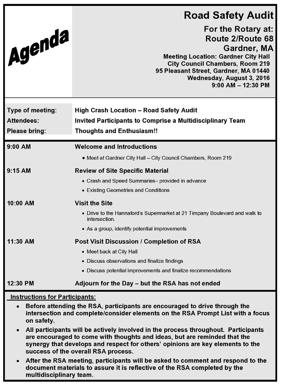
16 Appendix A. RSA Meeting Agenda
17
18 Appendix B. RSA Audit Team Contact List
19 Participating Audit Team Members Date: August 2, 2016 Location: Gardner City Hall Audit Team Members Agency/Affiliation Address Phone Number Lisa Schletzbaum David Posner Adam Prichard Joshua Bartus Rohith Prakash Davidson Borgelorme Joseph Frawley Erin Kinahan George Snow Massachusetts Highway Department Safety Section Massachusetts Highway Department - Safety Section Massachusetts Highway Department Safety Section Massachusetts Highway Department Highway Design Massachusetts Highway Department Highway Design Massachusetts Highway Department Highway Design Massachusetts Highway Department District 3 Traffic Massachusetts Highway Department - District 3 Traffic Montachusett Regional Planning Commission - Principal Transportation Planner lisa.schletzbaum@state.ma.us david.posner@state.ma.us adam.prichard@dot.state.ma.us joshua.bartus@dot.state.ma.us rohith.prakash@dot.state.ma.us Davidson.Borgelorme@dot.state.ma. us joseph.frawley@state.ma.us erin.kinahan@state.ma.us gsnow@mrpc.org Paul M. Capps Massachusetts State Police paul.capps@pol.state.ma.us Lt. Jerry Molet Massachusetts State Police jerry.molet@pol.state.ma.us Richard Ares Gardner, Fire Department rares@gardner-ma.gov Chris Coughlin Gardner, Engineering ccoughlin@gardner-ma.gov Bob Hankinson Gardner, Engineering rhankinson@gardner-ma.gov David Arnold Gardner, DPW darnold@gardner-ma.gov Jeff Legros Gardner, Planning jlegros@gardner-ma.gov Edward Myers Kittelson & Associates emyers@kittelson.com Conor Semler Kittelson & Associates csemler@kittelson.com Nancy Doherty Tetra Tech nancy.doherty@tetratech.com Courtney Jones Tetra Tech courtney.jones@tetratech.com
20 Appendix C. Detailed Crash Data
21
22
23
24

25
26
27
28 Appendix D. Speed Regulations
29
30
31
32
33
34
35
36
37
38 Appendix E. Road Safety Audit References
39 Road Safety Audit References Massachusetts Traffic Safety Toolbox, Massachusetts Highway Department, Road Safety Audits, A Synthesis of Highway Practice. NCHRP Synthesis 336. Transportation Research Board, National Cooperative Highway Research Program, Road Safety Audits. Institute of Transportation Engineers and U.S. Department of Transportation, Federal Highway Administration, FHWA Road Safety Audit Guidelines. U.S. Department of Transportation, Federal Highway Administration, Road Safety Audit, 2 nd edition. Austroads, Road Safety Audits. ITE Technical Council Committee 4S-7. Institute of Transportation Engineers, February 1995.
ROAD SAFETY AUDIT. Centre Street (Route 123) at Plymouth Street. Municipality of Brockton. November, Prepared For: MassDOT
 at Plymouth Street. Municipality of Brockton. November, Prepared For: MassDOT") ROAD SAFETY AUDIT Centre Street (Route 123) at Plymouth Street Municipality of Brockton November, 2017 Prepared For: MassDOT On Behalf Of: City of Brockton Prepared By: Old Colony Planning Council 70 School
ROAD SAFETY AUDIT Centre Street (Route 123) at Plymouth Street Municipality of Brockton November, 2017 Prepared For: MassDOT On Behalf Of: City of Brockton Prepared By: Old Colony Planning Council 70 School
ROAD SAFETY AUDIT. Route 16 at Interstate 395 Town of Webster. October Prepared For: MassDOT
 ROAD SAFETY AUDIT Route 16 at Interstate 395 Town of Webster October 2015 Prepared For: MassDOT Prepared By: McMahon Associates, Inc. 300 Myles Standish Blvd. Suite 201 Taunton, MA 02780 Table of Contents
ROAD SAFETY AUDIT. Neponset Street Rotary/Pendergast Circle. Town of Norwood. September Prepared For: On Behalf Of:
 ROAD SAFETY AUDIT Neponset Street Rotary/Pendergast Circle Town of Norwood September 2014 Prepared For: On Behalf Of: Westwood Marketplace Holdings LLC Prepared By: 35 New England Business Center Drive
ROAD SAFETY AUDIT. Route 2/Taylor Road/Piper Road. Town of Acton. March 4, Prepared For: Massachusetts Department of Transportation
 ROAD SAFETY AUDIT Route 2/Taylor Road/Piper Road Town of Acton March 4, 2015 Prepared For: Massachusetts Department of Transportation Prepared By: Tetra Tech, Inc. One Grant Street Framingham, MA 01702
ROAD SAFETY AUDIT. Granite Avenue at Interstate 93 Ramps. Town of Milton. May 22, Prepared for: MassDOT
 ROAD SAFETY AUDIT Granite Avenue at Interstate 93 Ramps Town of Milton May 22, 2017 Prepared for: MassDOT Prepared by: Toole Design Group 2 Oliver Street, Suite 305 Boston, MA 02109 Table of Contents Background...
ROAD SAFETY AUDIT. Route 114 at Interstate I-495 Northbound Ramps. City of Lawrence. July 30, 2015
 ROAD SAFETY AUDIT Route 114 at Interstate I-495 Northbound Ramps City of Lawrence July 30, 2015 Prepared For: Massachusetts Department of Transportation Prepared By: Toole Design Group 33 Broad Street,
ROAD SAFETY AUDIT. State Road (Route 6) Corridor Town of Dartmouth. March Prepared For: MassDOT
 Corridor Town of Dartmouth. March Prepared For: MassDOT") ROAD SAFETY AUDIT State Road (Route 6) Corridor Town of Dartmouth March 2015 Prepared For: MassDOT Prepared By: McMahon Associates, Inc. 300 Myles Standish Blvd. Suite 201 Taunton, MA 02780 Table of Contents
ROAD SAFETY AUDIT State Road (Route 6) Corridor Town of Dartmouth March 2015 Prepared For: MassDOT Prepared By: McMahon Associates, Inc. 300 Myles Standish Blvd. Suite 201 Taunton, MA 02780 Table of Contents
ROAD SAFETY AUDIT. Blue Hill Avenue (Route 28) and Warren Street High Crash Locations City of Boston. November 1, 2016
 and Warren Street High Crash Locations City of Boston. November 1, 2016") ROAD SAFETY AUDIT Blue Hill Avenue (Route 28) and Warren Street High Crash Locations City of Boston November 1, 2016 Prepared For: MassDOT Highway Division Prepared By: BETA Group, Inc. Table of Contents
ROAD SAFETY AUDIT Blue Hill Avenue (Route 28) and Warren Street High Crash Locations City of Boston November 1, 2016 Prepared For: MassDOT Highway Division Prepared By: BETA Group, Inc. Table of Contents
ROAD SAFETY AUDIT. Route 38 from Route 62 to Woburn Town Line. Town of Wilmington. April 10, Prepared For: MassDOT
 ROAD SAFETY AUDIT Route 38 from Route 62 to Woburn Town Line Town of Wilmington April 10, 2017 Prepared For: MassDOT Prepared By: Green International Affiliates, Inc. 239 Littleton Road, Suite 3, Westford,
Route 28 (South Orleans Road)/Route 39 (Harwich Road)/Quanset Road Intersection
/Route 39 (Harwich Road)/Quanset Road Intersection") TRAFFIC FEASIBILITY STUDY Route 28 (South Orleans Road)/Route 39 (Harwich Road)/Quanset Road Intersection Orleans, Massachusetts Prepared for: Town of Orleans Prepared by: Fay, Spofford & Thorndike, LLC
TRAFFIC FEASIBILITY STUDY Route 28 (South Orleans Road)/Route 39 (Harwich Road)/Quanset Road Intersection Orleans, Massachusetts Prepared for: Town of Orleans Prepared by: Fay, Spofford & Thorndike, LLC
ROAD SAFETY AUDIT. Santilli Circle and Sweetser Circle. Municipality of Everett. March 10, Prepared For: MassDOT
 ROAD SAFETY AUDIT Santilli Circle and Sweetser Circle Municipality of Everett Prepared For: MassDOT On Behalf Of: WYNN Design and Development Prepared By: AECOM 250 Apollo Drive Chelmsford, MA Road Safety
ROAD SAFETY AUDIT. East Main Street (Route 123) at Route I-495 Northbound & Southbound Ramps Town of Norton. May 11, Prepared For: MassDOT
 at Route I-495 Northbound & Southbound Ramps Town of Norton. May 11, Prepared For: MassDOT") ROAD SAFETY AUDIT East Main Street (Route 123) at Route I-495 Northbound & Southbound Ramps Town of Norton May 11, 2016 Prepared For: MassDOT Prepared By: 101 Walnut Street Watertown, MA Road Safety Audit
ROAD SAFETY AUDIT East Main Street (Route 123) at Route I-495 Northbound & Southbound Ramps Town of Norton May 11, 2016 Prepared For: MassDOT Prepared By: 101 Walnut Street Watertown, MA Road Safety Audit
Falmouth Road Safety Audit
 Falmouth Road Safety Audit Sandwich Road: Carriage Shop Road to Hatchville Road September 2011 Prepared by the Cape Cod Commission in cooperation with the Town of Falmouth and Massachusetts Department
ROAD SAFETY AUDIT. May 18, Prepared For: MassDOT. On Behalf Of: Town of Milford
 ROAD SAFETY AUDIT East Main Street (Route 16) at Medway Road (Route 109), East Main Street (Route 16) at Quarry Square Driveways, East Main Street (Route 16) at Beaver Street/ Fortune Boulevard Town of
ROAD SAFETY AUDIT. Route 202 (East State Street)/School Street & Route 202 (West State Street)/Pleasant Street/Amherst Street Town of Granby
/School Street & Route 202 (West State Street)/Pleasant Street/Amherst Street Town of Granby") ROAD SAFETY AUDIT Route 202 (East State Street)/School Street & Route 202 (West State Street)/Pleasant Street/Amherst Street Town of Granby March 2013 Prepared for: Massachusetts Department of Transportation
ROAD SAFETY AUDIT Route 202 (East State Street)/School Street & Route 202 (West State Street)/Pleasant Street/Amherst Street Town of Granby March 2013 Prepared for: Massachusetts Department of Transportation
ROAD SAFETY AUDIT. Russell Street (Route 9) at North and South Maple Streets Town of Hadley. March 2014
 at North and South Maple Streets Town of Hadley. March 2014") ROAD SAFETY AUDIT Russell Street (Route 9) at North and South Maple Streets Town of Hadley March 2014 Prepared for: Massachusetts Department of Transportation Prepared by: Howard/Stein-Hudson Associates
ROAD SAFETY AUDIT Russell Street (Route 9) at North and South Maple Streets Town of Hadley March 2014 Prepared for: Massachusetts Department of Transportation Prepared by: Howard/Stein-Hudson Associates
MEMORANDUM. Layout Of Study Intersections And Traffic Control
 BOSTON REGION METROPOLITAN PLANNING ORGANIZATION Richard A. Davey, MassDOT Secretary and CEO and MPO Chairman Karl H. Quackenbush, Executive Director, MPO Staff DATE November 15, 2012 TO FROM RE Town of
AGENDA ITEM 6 D THOMASVILLE ROAD (HERMITAGE BOULEVARD TO LIVE OAK PLANTATION ROAD) ROADWAY SAFETY AUDIT
 ROADWAY SAFETY AUDIT") May 15, 2018 AGENDA ITEM 6 D THOMASVILLE ROAD (HERMITAGE BOULEVARD TO LIVE OAK PLANTATION ROAD) ROADWAY SAFETY AUDIT TYPE OF ITEM: Discussion STATEMENT OF ISSUE The Florida Department of Transportation
May 15, 2018 AGENDA ITEM 6 D THOMASVILLE ROAD (HERMITAGE BOULEVARD TO LIVE OAK PLANTATION ROAD) ROADWAY SAFETY AUDIT TYPE OF ITEM: Discussion STATEMENT OF ISSUE The Florida Department of Transportation
MEMORANDUM. Date: 9/13/2016. Citywide Crosswalk Policy
 MEMORANDUM Date: 9/13/2016 Re: Citywide Crosswalk Policy Foreword Through the s Circulation Element and Complete Streets Policy, it is the City s goal to promote walking trips and provide safe facilities
Draft North Industrial Area-Wide Traffic Plan
 Summary of North Industrial and Hudson Bay Industrial Recommended Improvements Table 1. Summary of s Item Location 1 2 3 4 5 6 7 8 9 10 11 12 Millar Ave north of 51st St Super 8 Motel back lane 400 Block
ROAD SAFETY AUDIT. Route 135 at Route 30 Town of Westborough. January Prepared For: MassDOT
 ROAD SAFETY AUDIT Route 135 at Route 30 January 2016 Prepared For: MassDOT Prepared By: McMahon Associates, Inc. 300 Myles Standish Blvd. Suite 201 Taunton, MA 02780 Road Safety Audit Route 135 at Route
ROAD SAFETY AUDIT MDM. Columbia Road at Dorchester Avenue. Dorchester, MA 10/14/2016. Prepared For: MassDOT. On Behalf Of: Edens
 ROAD SAFETY AUDIT Columbia Road at Dorchester Avenue Dorchester, MA 10/14/2016 Prepared For: MassDOT On Behalf Of: Edens Prepared By: MDM Transportation Consultants, Inc. 28 Lord Road Suite 280 Marlborough,
ROAD SAFETY AUDIT. Route 53 (Washington Street) High Crash Locations at Route 139 (Schoosett Street) and Route 14 (Congress Street) Town of Pembroke
 High Crash Locations at Route 139 (Schoosett Street) and Route 14 (Congress Street) Town of Pembroke") ROAD SAFETY AUDIT Route 53 (Washington Street) High Crash Locations at Route 139 (Schoosett Street) and Route 14 (Congress Street) Town of Pembroke April 29, 2016 Prepared For: MassDOT Highway Division
ROAD SAFETY AUDIT Route 53 (Washington Street) High Crash Locations at Route 139 (Schoosett Street) and Route 14 (Congress Street) Town of Pembroke April 29, 2016 Prepared For: MassDOT Highway Division
Traffic Study of Fuller Street, Cady Street, West Street and West Avenue. Final Report
 Traffic Study of Fuller Street, Cady Street, West Street and West Avenue Final Report July 2005 Prepared for: Town of Ludlow Prepared by: Pioneer Valley Planning Commission 26 Central Street West Springfield,
Meadow Woods Elementary School
 Drag and drop pic and stretch/crop to the limits of the blue rectangle (delete this text box) Meadow Woods Elementary School Drag and drop pic and stretch/crop to the limits of the blue rectangle (delete
ROAD SAFETY AUDIT. Washington Street (Route 53) at Pleasant Street. Town of Pembroke. June 26, Prepared For: MassDOT Highway Division
 at Pleasant Street. Town of Pembroke. June 26, Prepared For: MassDOT Highway Division") ROAD SAFETY AUDIT Washington Street (Route 53) at Pleasant Street Town of Pembroke June 26, 2014 Prepared For: MassDOT Highway Division Prepared By: BETA Group, Inc. Table of Contents Project Data... 1
ROAD SAFETY AUDIT Washington Street (Route 53) at Pleasant Street Town of Pembroke June 26, 2014 Prepared For: MassDOT Highway Division Prepared By: BETA Group, Inc. Table of Contents Project Data... 1
ROAD SAFETY AUDIT. Providence Street (Route 122A) at McKeon Road/Millbury Street. City of Worcester. July 14, Prepared For: MassDOT
 at McKeon Road/Millbury Street. City of Worcester. July 14, Prepared For: MassDOT") ROAD SAFETY AUDIT Providence Street (Route 122A) at McKeon Road/Millbury Street City of Worcester July 14, 2016 Prepared For: MassDOT Prepared By: Stantec Consulting Services, Inc. Burlington, Massachusetts
ROAD SAFETY AUDIT Providence Street (Route 122A) at McKeon Road/Millbury Street City of Worcester July 14, 2016 Prepared For: MassDOT Prepared By: Stantec Consulting Services, Inc. Burlington, Massachusetts
City of Albert Lea Policy and Procedure Manual 4.10 ALBERT LEA CROSSWALK POLICY
 4.10 ALBERT LEA CROSSWALK POLICY PURPOSE: Pedestrian crosswalks are an integral part of our transportation infrastructure. To be effective and promote safety, marked crosswalks must be installed after
ROAD SAFETY AUDIT. County Street at Hart Street. City of Taunton. January 30, Prepared For: Massachusetts Department of Transportation
 ROAD SAFETY AUDIT County Street at Hart Street City of Taunton January 30, 2015 Prepared For: Massachusetts Department of Transportation Prepared By: Toole Design Group 33 Broad Street, 4 th Floor Boston,
ROAD SAFETY AUDIT. Route 1 at Route 123 Route 1 at Route 1A Route 1 at May Street Route 1A and Route 123. City of Attleboro, MA. September 15, 2015
 ROAD SAFETY AUDIT Route 1 at Route 123 Route 1 at Route 1A Route 1 at May Street Route 1A and Route 123 City of Attleboro, MA September 15, 2015 Prepared For: MassDOT On Behalf Of: Prepared By: Fay, Spofford
ROAD SAFETY AUDIT. Route 3A from Evans Street to Abigail Adams State Park. Town of Weymouth. October 12, Prepared For: MassDOT
 ROAD SAFETY AUDIT Route 3A from Evans Street to Abigail Adams State Park Town of Weymouth October 12, 2016 Prepared For: MassDOT Prepared By: Green International Affiliates, Inc. 239 Littleton Road, Suite
Yarmouth Road Safety Audit September 2011
 Yarmouth Road Safety Audit Union Street Station Avenue At U.S. Route 6 Ramps September 2011 Prepared by the Cape Cod Commission In cooperation with The Town of Brewster And MassDOT Highway Division Table
Hidden Oaks Elementary School
 Hidden Oaks Elementary School SCHOOL ROUTE PLAN For HIDDEN OAKS ELEMENTARY SCHOOL LOCATION 13 ORANGE COUNTY Prepared for: ORANGE COUNTY SCHOOL ASSESSMENT PROGRAM ORANGE COUNTY PUBLIC WORKS Traffic Engineering
ROAD SAFETY AUDIT. West Central Street (Route 140) at Franklin Village Drive. Town of Franklin. February 03, 2016
 at Franklin Village Drive. Town of Franklin. February 03, 2016") ROAD SAFETY AUDIT West Central Street (Route 140) at Franklin Village Drive Town of Franklin February 03, 2016 Prepared for: Massachusetts Department of Transportation Prepared by: Howard Stein Hudson
ROAD SAFETY AUDIT West Central Street (Route 140) at Franklin Village Drive Town of Franklin February 03, 2016 Prepared for: Massachusetts Department of Transportation Prepared by: Howard Stein Hudson
ROAD SAFETY AUDIT. Mass Pike Interchange 6, I-291 and Burnett Road. City of Chicopee. November 4, Prepared For: MassDOT Highway Division
 ROAD SAFETY AUDIT Mass Pike Interchange 6, I-291 and Burnett Road City of Chicopee November 4, 2013 Prepared For: MassDOT Highway Division Prepared By: BETA Group, Inc. Table of Contents Project Data...
Figure 3B-1. Examples of Two-Lane, Two-Way Marking Applications
 Figure 3B-1. Examples of Two-Lane, Two-Way Marking Applications A - Typical two-lane, two-way marking with passing permitted in both directions B - Typical two-lane, two-way marking with no-passing zones
A plan for improved motor vehicle access on Railroad Avenue in Provincetown
 A plan for improved motor vehicle access on Railroad Avenue in Provincetown February 2011 A plan for improved motor vehicle access on Railroad Avenue in Provincetown INTRODUCTION AND PROBLEM IDENTIFICATION
Orange Center Elementary School
 Drag and drop pic and stretch/crop to the limits of the blue rectangle (delete this text box) Orange Center Elementary School Drag and drop pic and stretch/crop to the limits of the blue rectangle (delete
ROAD SAFETY AUDIT. South Street (Route 1A) at East Bacon Street (Route 106) and West Bacon Street Town of Plainville.
 at East Bacon Street (Route 106) and West Bacon Street Town of Plainville.") ROAD SAFETY AUDIT South Street (Route 1A) at East Bacon Street (Route 106) and West Bacon Street Town of Plainville March 15, 2018 Prepared For: MassDOT On Behalf Of: Town of Plainville Prepared By: BETA
ROAD SAFETY AUDIT South Street (Route 1A) at East Bacon Street (Route 106) and West Bacon Street Town of Plainville March 15, 2018 Prepared For: MassDOT On Behalf Of: Town of Plainville Prepared By: BETA
CHAPTER 3A. GENERAL PAGE CHAPTER 3B. PAVEMENT AND CURB MARKINGS PAGE
 Virginia Supplement to the 2009 MUTCD Revision 1 Page TC-3-1 PART 3. MARKINGS CHAPTER 3A. GENERAL PAGE Section 3A.01 Functions and Limitations Section 3A.02 Standardization of Application Section 3A.03
Attachment No. 4 Approved by National Committee Council
 Attachment No. 4 Approved by National Committee Council The Signals Technical Committee distributed a technical committee recommendation to sponsors concerning pedestrian hybrid beacons following the January
Lake Whitney Elementary School
 Lake Whitney Elementary School SCHOOL ROUTE PLAN For LAKE WHITNEY ELEMENTARY SCHOOL LOCATION 18 ORANGE COUNTY Prepared for: ORANGE COUNTY SCHOOL ASSESSMENT PROGRAM ORANGE COUNTY PUBLIC WORKS Traffic Engineering
TRAFFIC IMPACT ANALYSIS
 TRAFFIC IMPACT ANALYSIS FOR THE CHAMPAIGN UNIT#4 SCHOOL DISTRICT PROPOSED HIGH SCHOOL (SPALDING PARK SITE) IN THE CITY OF CHAMPAIGN Final Report Champaign Urbana Urbanized Area Transportation Study 6/24/2014
FLORIDA DEPARTMENT OF TRANSPORTATION DISTRICT 7 DISTRICT WIDE BICYCLE/PEDESTRIAN ACCESS TO TRANSIT SAFETY ASSESSMENT AND IMPROVEMENT PLAN
 FLORIDA DEPARTMENT OF TRANSPORTATION DISTRICT 7 DISTRICT WIDE BICYCLE/PEDESTRIAN ACCESS TO TRANSIT SAFETY ASSESSMENT AND IMPROVEMENT PLAN TRANSIT SAFETY ASSESSMENT SR 55/US 19 AT 80 TH AVE N DRAFT JUNE
ROAD SAFETY AUDIT. Route 18 (Bedford Street) from Whitman Street to Central Square Town of East Bridgewater. May 14, 2014
 from Whitman Street to Central Square Town of East Bridgewater. May 14, 2014") ROAD SAFETY AUDIT Route 18 (Bedford Street) from Whitman Street to Central Square Town of East Bridgewater May 14, 2014 Prepared For: MassDOT Highway Division Prepared By: BETA Group, Inc. Table of Contents
ROAD SAFETY AUDIT Route 18 (Bedford Street) from Whitman Street to Central Square Town of East Bridgewater May 14, 2014 Prepared For: MassDOT Highway Division Prepared By: BETA Group, Inc. Table of Contents
M-58 HIGHWAY ACCESS MANAGEMENT STUDY Mullen Road to Bel-Ray Boulevard. Prepared for CITY OF BELTON. May 2016
 M-58 HIGHWAY ACCESS MANAGEMENT STUDY Prepared for CITY OF BELTON By May 2016 Introduction Missouri State Highway 58 (M-58 Highway) is a major commercial corridor in the City of Belton. As development has
MEMORANDUM. Nantasket Road at Kingsley Road Kingsley Road at Sumner Street Kingsley Road at Revere Street Kingsley Road at Kenberma Street
 MEMORANDUM Date: June 28, 2012 To: From: Subject: Mr. Joseph Stigliani, Director of Public Works Kenneth J. Petraglia, P.E., PTOE Greg E. Lucas, P.E., PTOE Kingsley Road Stop Sign Warrant Analysis BETA
Drag and drop pic and stretch/crop to the limits of the blue rectangle (delete this text box) Maxey Elementary School
 Maxey Elementary School") Drag and drop pic and stretch/crop to the limits of the blue rectangle (delete this text box) Maxey Elementary School SCHOOL ROUTE PLAN For MAXEY ELEMENTARY SCHOOL LOCATION 33 ORANGE COUNTY Prepared for:
Drag and drop pic and stretch/crop to the limits of the blue rectangle (delete this text box) Maxey Elementary School SCHOOL ROUTE PLAN For MAXEY ELEMENTARY SCHOOL LOCATION 33 ORANGE COUNTY Prepared for:
ROAD SAFETY AUDIT. Water Street (Route 129) at Vernon Street. Town of Wakefield. September Prepared For: MassDOT
 at Vernon Street. Town of Wakefield. September Prepared For: MassDOT") ROAD SAFETY AUDIT Water Street (Route 129) at Vernon Street September 2017 Prepared For: MassDOT Massachusetts Department of Transportation Prepared By: WorldTech Engineering Road Safety Audit Water Street
ROAD SAFETY AUDIT Water Street (Route 129) at Vernon Street September 2017 Prepared For: MassDOT Massachusetts Department of Transportation Prepared By: WorldTech Engineering Road Safety Audit Water Street
Road Safety Audit for the Intersection of VFW Highway & Bridge Street in Lowell, Massachusetts
 Road Safety Audit for the Intersection of VFW Highway & Bridge Street in Lowell, Massachusetts Prepared by University of Massachusetts Traffic Safety Research Program Prepared for Massachusetts Highway
INTERSECTION SAFETY AUDIT: STH 16/67 AND CTH Z
 WISCONSIN DEPARTMENT OF TRANSPORTATION INTERSECTION SAFETY AUDIT: STH 16/67 AND CTH Z OCONOMOWOC, WI WISCONSIN DEPARTMENT OF TRANSPORTATION INTERSECTION SAFETY AUDIT: STH 16/67 AND CTH Z OCONOMOWOC, WI
Chapter 2: Standards for Access, Non-Motorized, and Transit
 Standards for Access, Non-Motorized, and Transit Chapter 2: Standards for Access, Non-Motorized, and Transit The Washtenaw County Access Management Plan was developed based on the analysis of existing
Windy Ridge Elementary School
 Windy Ridge Elementary School SCHOOL ROUTE PLAN For WINDY RIDGE ELEMENTARY SCHOOL LOCATION 54 ORANGE COUNTY Prepared for: ORANGE COUNTY SCHOOL ASSESSMENT PROGRAM ORANGE COUNTY PUBLIC WORKS Traffic Engineering
INDEX. Geometric Design Guide for Canadian Roads INDEX
 Acceleration lane, see Lanes, Acceleration Access, 8.1 Access Management and Functional Classification 8.2 Access Management by Design Classification 8.3 Access Configuration 8.4 Building Set-Back Guidelines
ALLEY 24 TRAFFIC STUDY
 ALLEY 24 TRAFFIC STUDY in City of Frostburg, Maryland January 2013 3566 Teays Valley Road Hurricane, WV Office: (304) 397-5508 www.denniscorporation.com Alley 24 Traffic Study January 2013 Frostburg, Maryland
ROUNDABOUTS/TRAFFIC CIRCLES
 GENERAL 1. Description This standard identifies minimum requirements that shall be met for Roundabouts and Neighborhood Traffic Circles in the design and construction of elements for Arlington County Horizontal
DEPARTMENT OF ENVIRONMENTAL SERVICES. North Harrison Street (Lee Highway to Little Falls Road) Comparative Analysis. Prepared for:
 Comparative Analysis. Prepared for:") DEPARTMENT OF ENVIRONMENTAL SERVICES North Harrison Street (Lee Highway to Little Falls Road) Comparative Analysis Prepared for: Arlington County Department of Environmental Services 2100 Clarendon Boulevard,
DEPARTMENT OF ENVIRONMENTAL SERVICES North Harrison Street (Lee Highway to Little Falls Road) Comparative Analysis Prepared for: Arlington County Department of Environmental Services 2100 Clarendon Boulevard,
Multi-Modal Traffic Analysis. Parisi and Associates
 Mill Valley to Corte Madera Bicycle and Pedestrian Corridor Study Appendix D: Multi-Modal Traffic Analysis Prepared by Parisi and Associates August 2009 Appendix D - Multi-Modal Traffic Analysis Table
Attachment No. 13. National Committee on Uniform Traffic Control Devices RWSTC RECOMMENDATION FOLLOWING SPONSOR COMMENTS
 1 2 3 4 Attachment No. 13 5 6 7 8 9 10 11 12 13 14 15 16 17 18 19 20 21 22 23 24 25 26 27 28 29 30 31 32 33 34 35 36 37 38 39 40 41 42 43 RWSTC agenda item IV. 2 June 2011 National Committee on Uniform
ROAD SAFETY AUDIT. Route 27 (Crescent Street)/Quincy Street/Massasoit Boulevard. City of Brockton. July 24,2013
/Quincy Street/Massasoit Boulevard. City of Brockton. July 24,2013") ROAD SAFETY AUDIT Route 27 (Crescent Street)/Quincy Street/Massasoit Boulevard City of Brockton July 24,2013 Prepared for: Massachusetts Department of Transportation Prepared by: Howard/Stein-Hudson Associates
ROAD SAFETY AUDIT Route 27 (Crescent Street)/Quincy Street/Massasoit Boulevard City of Brockton July 24,2013 Prepared for: Massachusetts Department of Transportation Prepared by: Howard/Stein-Hudson Associates
Date: April 4, Project #: Re: A Street/Binford Street Traffic/Intersection Assessment
 To: Peter Cavanaugh General Electric From: David Bohn, PE Ryan White, PE Date: April 4, 217 Project #: 13421. Re: / Traffic/Intersection Assessment Consistent with the Cooperation Agreement between the
Clay Street Bridge Replacement Project
 Clay Street Bridge Replacement Project Frequently Asked Questions (FAQs) The project is located in downtown Placerville on Clay Street between US Highway 50 and Main Street and Cedar Ravine Road. The proposed
ROAD SAFETY AUDIT. Damon Road. City of Northampton. October Prepared for: Massachusetts Department of Transportation
 ROAD SAFETY AUDIT Damon Road City of Northampton October 2013 Prepared for: Massachusetts Department of Transportation Prepared by: Howard/Stein-Hudson Associates 38 Chauncy Street Boston, MA 02111 Table
Toolbox of Countermeasures and Their Potential Effectiveness to Make Intersections Safer
 8 Toolbox of Countermeasures and Their to Make Intersections Safer Introduction Studies included in the NCHRP 17-18 (3), Guidance for Implementation of the AASHTO Strategic Highway Safety Plan, as well
Truck Climbing Lane Traffic Justification Report
 ROUTE 7 (HARRY BYRD HIGHWAY) WESTBOUND FROM WEST MARKET STREET TO ROUTE 9 (CHARLES TOWN PIKE) Truck Climbing Lane Traffic Justification Report Project No. 6007-053-133, P 101 Ι UPC No. 58599 Prepared by:
THE FUTURE OF THE TxDOT ROADWAY DESIGN MANUAL
 THE FUTURE OF THE TXDOT ROADWAY DESIGN MANUAL Kenneth Mora, P.E. (Design Division) 10/10/2017 Table of contents 1 2 Reduction in FHWA design controlling criteria Innovative Intersection Guidance 3-7 8-42
Broad Street Bicycle Boulevard Design Guidelines
 Broad Street Bicycle Boulevard Design Guidelines Building from the strategies introduced in the 2013 Bicycle Transportation Plan and community input received thus far, City Transportation Staff have identified
PEDESTRIAN SAFETY IMPROVEMENT EVALUATION GUIDELINE FOR UNCONTROLLED CROSSINGS
 PEDESTRIAN SAFETY IMPROVEMENT EVALUATION GUIDELINE FOR UNCONTROLLED CROSSINGS Traffic Safety Engineering Division Updated: April 2018 EXECUTIVE SUMMARY NDOT Traffic Safety Engineering Division developed
Developed by: The American Traffic Safety Services Association (ATSSA) 15 Riverside Parkway, Suite 100 Fredericksburg, VA
 15 Riverside Parkway, Suite 100 Fredericksburg, VA") Addendum Developed by: The American Traffic Safety Services Association (ATSSA) 15 Riverside Parkway, Suite 100 Fredericksburg, VA 22406-1022 800-272-8772 This material is based upon work supported by
Addendum Developed by: The American Traffic Safety Services Association (ATSSA) 15 Riverside Parkway, Suite 100 Fredericksburg, VA 22406-1022 800-272-8772 This material is based upon work supported by
Evaluation of M-99 (Broad Street) Road Diet and Intersection Operational Investigation
 Road Diet and Intersection Operational Investigation") Evaluation of M-99 (Broad Street) Road Diet and Intersection Operational Investigation City of Hillsdale, Hillsdale County, Michigan June 16, 2016 Final Report Prepared for City of Hillsdale 97 North Broad
Evaluation of M-99 (Broad Street) Road Diet and Intersection Operational Investigation City of Hillsdale, Hillsdale County, Michigan June 16, 2016 Final Report Prepared for City of Hillsdale 97 North Broad
Markings Technical Committee Chapter 3H: Roundabout Markings APPROVED IN NCUTCD COUNCIL ON JANUARY 20, 2006
 ATTACHMENT NO. 30 Markings Technical Committee Chapter 3H: Roundabout Markings APPROVED IN NCUTCD COUNCIL ON JANUARY 20, 2006 Roundabouts are becoming an increasingly utilized form of intersection design
ROAD SAFETY AUDIT. Route 1 at Everett Street & University Avenue. Town of Norwood. September Prepared For: On Behalf Of:
 ROAD SAFETY AUDIT Route 1 at Everett Street & University Avenue Town of Norwood September 2014 Prepared For: On Behalf Of: Westwood Marketplace Holdings LLC Prepared By: 35 New England Business Center
Summary: Mercer County Princeton Avenue & Spruce Street Study January 2009
 Summary: Several recent studies have assessed potential development and redevelopment opportunities in the Mercer Crossing area of Trenton, Ewing, and Lawrence. This Princeton Avenue and Spruce Street
University Hill Transportation Study Technical Memorandum Alternatives Modeling and Analysis May 2007
 Technical Memorandum May 2007 Syracuse Metropolitan Transportation Council Edwards and Kelcey with Wallace Roberts and Todd Alta Planning and Design CONTENTS SECTION ONE- INTRODUCTION...1 SECTION TWO-
ROAD SAFETY AUDIT. Northampton Road (Route 9) at University Drive and Snell Street Town of Amherst. November 15, Prepared For: MassDOT
 at University Drive and Snell Street Town of Amherst. November 15, Prepared For: MassDOT") ROAD SAFETY AUDIT Northampton Road (Route 9) at University Drive and Snell Street Town of Amherst November 15, 2016 Prepared For: MassDOT Prepared By: Greenman-Pedersen, Inc. 181 Ballardvale Street, Suite
ROAD SAFETY AUDIT Northampton Road (Route 9) at University Drive and Snell Street Town of Amherst November 15, 2016 Prepared For: MassDOT Prepared By: Greenman-Pedersen, Inc. 181 Ballardvale Street, Suite
TRAFFIC CALMING GUIDE FOR TORONTO CITY OF TORONTO TRANSPORTATION SERVICES DIVISION
 TRAFFIC CALMING GUIDE FOR TORONTO CITY OF TORONTO TRANSPORTATION SERVICES DIVISION CITY OF TORONTO TRANSPORTATION SERVICES DIVISION 2016 TRAFFIC CALMING GUIDE FOR TORONTO TABLE OF CONTENTS Introduction
Broadway Street Pedestrian Safety Study Cass Street to 700 Feet North of Randall Avenue
 Broadway Street Pedestrian Safety Study Cass Street to 700 Feet North of Randall Avenue Prepared for: City of De Pere, Wisconsin Prepared by: June, 2017 Broadway Street Pedestrian Safety Study Cass Street
Memorandum. Sunday, July 13, Saturday, July 19, 2014
 Memorandum To: David Lowin, Brooklyn Bridge Park Corporation From: Daniel Schack, AICP, PTP Date: Re: Brooklyn Bridge Park Pier 5/6 Loop Road Traffic Study Project No: 14-01-2407 At the request of Brooklyn
ROAD SAFETY AUDIT. Route 113 (Storey Avenue) at Woodman Way and Low Street. Newburyport, MA. May 27, Prepared For: MassDOT
 at Woodman Way and Low Street. Newburyport, MA. May 27, Prepared For: MassDOT") ROAD SAFETY AUDIT Route 113 (Storey Avenue) at Woodman Way and Low Street Newburyport, MA May 27, 2015 Prepared For: MassDOT Prepared By: Bayside Engineering, Inc. 600 Unicorn Park Drive Woburn, MA 01801
ROAD SAFETY AUDIT Route 113 (Storey Avenue) at Woodman Way and Low Street Newburyport, MA May 27, 2015 Prepared For: MassDOT Prepared By: Bayside Engineering, Inc. 600 Unicorn Park Drive Woburn, MA 01801
Appendix A. Knoxville TPO Greenway Signage Guidelines. Appendix A: Knoxville TPO Greenway Signage Guidelines Knox to Oak Ridge Greenway Master Plan
 Appendix A Knoxville TPO Greenway Signage Guidelines 75 Overview: Adequate signing and marking are essential on shared-use paths, especially to alert bicyclists to potential conflicts and to convey regulatory
(This page left intentionally blank)
") (This page left intentionally blank) 2011 Edition- Revision 2 Page 813 CHAPTER 9A. GENERAL Section 9A.01 Requirements for Bicyclist Traffic Control Devices 01 General information and definitions concerning
(This page left intentionally blank) 2011 Edition- Revision 2 Page 813 CHAPTER 9A. GENERAL Section 9A.01 Requirements for Bicyclist Traffic Control Devices 01 General information and definitions concerning
MEMORANDUM. DATE March 1, 2012 TO Town of Milton Mark Abbott, Seth Asante, and Efi Pagitsas Boston Region MPO Staff
 MEMORANDUM DATE March 1, 212 TO Town of Milton FROM RE Mark Abbott, Seth Asante, and Efi Pagitsas Boston Region MPO Staff FFY 211 Safety and Operations Analyses at Selected Boston Region MPO Intersections:
Glenn Avenue Corridor Traffic Operational Evaluation
 Glenn Avenue Corridor Traffic Operational Evaluation PREPARED FOR: THE CITY OF AUBURN PREPARED BY: DECEMBER 2007 Glenn Avenue Corridor Study--Auburn, Alabama TABLE OF CONTENTS Introduction... 1 Background
ROAD SAFETY AUDIT. Rourke Bridge at Pawtucket Boulevard (Route 113) City of Lowell. October 5, Prepared For: MassDOT.
 City of Lowell. October 5, Prepared For: MassDOT.") ROAD SAFETY AUDIT Rourke Bridge at Pawtucket Boulevard (Route 113) City of Lowell October, 2017 Prepared For: MassDOT Prepared By: Vanasse Hangen Brustlin, Inc 101 Walnut Street Watertown, MA 02472 Road
ROAD SAFETY AUDIT Rourke Bridge at Pawtucket Boulevard (Route 113) City of Lowell October, 2017 Prepared For: MassDOT Prepared By: Vanasse Hangen Brustlin, Inc 101 Walnut Street Watertown, MA 02472 Road
DRAFT. Corridor study. Honeysuckle Road. October Prepared for the City of Dothan, AL. Prepared by Gresham, Smith and Partners
 DRAFT Corridor study Honeysuckle Road October 2017 Prepared for the City of Dothan, AL Prepared by TABLE OF CONTENTS SECTION I... 1 STUDY SUMMARY... 1 INTRODUCTION... 1 CONCLUSIONS... 5 SECTION II... 7
180 Grand Avenue, Suite x117 Dowling Associates, Inc.
 180 Grand Avenue, Suite 250 510.839.1742 x117 Oakland, CA 94612 510.839.0871 fax www.dowlinginc.com mbowman@dowlinginc.com Dowling Associates, Inc. Date: Memorandum To: CC: From: Ms. Leah Greenblat City
Section 9A.07 Meaning of Standard, Guidance, Option, and Support
 2012 Edition Page 895 PART 9. TRAFFIC CONTROLS FOR BICYCLE FACILITIES CHAPTER 9A. GENERAL Section 9A.01 Requirements for Bicyclist Traffic Control Devices 01 General information and definitions concerning
CITY OF LOS ANGELES INTER-DEPARTMENTAL MEMORANDUM
 CITY OF LOS ANGELES INTER-DEPARTMENTAL MEMORANDUM Date: April 1, 219 To: Honorable City Council c/o City Clerk, Room 395, City Hall Attention: Honorable Mike Bonin, Chair, Transportation Committee From:
ROAD SAFETY AUDIT. Boston Road (Route 20) at Parker Street and Pasco Road to Dumaine Street City of Springfield Town of Wilbraham.
 at Parker Street and Pasco Road to Dumaine Street City of Springfield Town of Wilbraham.") ROAD SAFETY AUDIT Boston Road (Route 2) at Parker Street and Pasco Road to Dumaine Street City of Springfield Town of Wilbraham October 4, 212 Prepared For: MassDOT Highway Division Prepared By: BETA Group,
ROAD SAFETY AUDIT Boston Road (Route 2) at Parker Street and Pasco Road to Dumaine Street City of Springfield Town of Wilbraham October 4, 212 Prepared For: MassDOT Highway Division Prepared By: BETA Group,
Appendix A: Crosswalk Policy
 Appendix A: Crosswalk Policy Appendix A: Crosswalk Policy Introduction This citywide Crosswalk Policy is aimed at improving pedestrian safety and enhancing pedestrian mobility by providing a framework
ROAD SAFETY AUDIT. Auburn Street at Southbridge Street (Route 12) Town of Auburn. March Prepared For: Massachusetts Department of Transportation
 Town of Auburn. March Prepared For: Massachusetts Department of Transportation") ROAD SAFETY AUDIT Auburn Street at Southbridge Street (Route 12) Town of Auburn March 2017 Prepared For: Massachusetts Department of Transportation Prepared By: Vanasse Hangen Brustlin, Inc Union Station
ROAD SAFETY AUDIT Auburn Street at Southbridge Street (Route 12) Town of Auburn March 2017 Prepared For: Massachusetts Department of Transportation Prepared By: Vanasse Hangen Brustlin, Inc Union Station
Appendix T CCMP TRAIL TRAFFIC & TRANSPORTATION DESIGN STANDARD
 Appendix T CCMP 3.3.4 TRAIL TRAFFIC & TRANSPORTATION DESIGN STANDARD 3.3.4 Trail Traffic and Transportation Design Multi-use trails have certain design standards, which vary depending on the agency that
DEFINITIONS Activity Area - Advance Warning Area Advance Warning Sign Spacing Advisory Speed Approach Sight Distance Attended Work Space
 DEFINITIONS Activity Area - that part of a TTC zone activity area where the work actually takes place. It consists of the work space, traffic space and one or more buffer spaces. Advance Warning Area -
METHODOLOGY. Signalized Intersection Average Control Delay (sec/veh)
") Chapter 5 Traffic Analysis 5.1 SUMMARY US /West 6 th Street assumes a unique role in the Lawrence Douglas County transportation system. This principal arterial street currently conveys commuter traffic
Chapter 5 Traffic Analysis 5.1 SUMMARY US /West 6 th Street assumes a unique role in the Lawrence Douglas County transportation system. This principal arterial street currently conveys commuter traffic
Truck Turning Study for Main Street Intersection, Orange
 Truck Turning Study for Main Street Intersection, Orange Franklin Regional Council of Governments September 2015 0 Truck Turning Study for Main Street Intersection, Orange September 2015 Prepared by: Franklin
Guidance. ATTACHMENT F: Draft Additional Pages for Bicycle Facility Design Toolkit Separated Bike Lanes: Two-Way to One-Way Transitions
 ATTACHMENT F: Draft Additional Pages for Bicycle Facility Design Toolkit Separated Bike Lanes: Two-Way to One-Way Transitions This treatment provides a transition from two-way separated bike lanes to one-way
Traffic Signal Phasing Study Summary & Staff Recommendations
 Traffic Signal Phasing Study Summary & Staff Recommendations Consultant Study by Skipper Consulting, Inc. Staff Committee Recommendations by Randy Pewitt, Executive Director of Emergency Mgt. and Safety
Design Criteria. Design Criteria
 F Design Criteria Design Criteria Ministry of Transportation Ministère des Transports DESIGN CRITERIA Page: 1 of 13 WORK PROJECT NO. N/A GO Bloomington Station TYPE OF PROJECT LOCATION Bloomington Road
2.0 LANE WIDTHS GUIDELINE
 2.0 LANE WIDTHS GUIDELINE Road Engineering Design Guidelines Version 2.0.1 May 2018 City of Toronto, Transportation Services City of Toronto Page 0 Background In early 2014, Transportation Services initiated
Ottawa Beach Road Study
 Ottawa Beach Road Study Prepared For: Park Township September 30, 2014 Project No. G140303 OTTAWA BEACH ROAD STUDY PREPARED FOR: PARK TOWNSHIP SEPTEMBER 30, 2014 PROJECT NO. G140303 TABLE OF CONTENTS 1.0