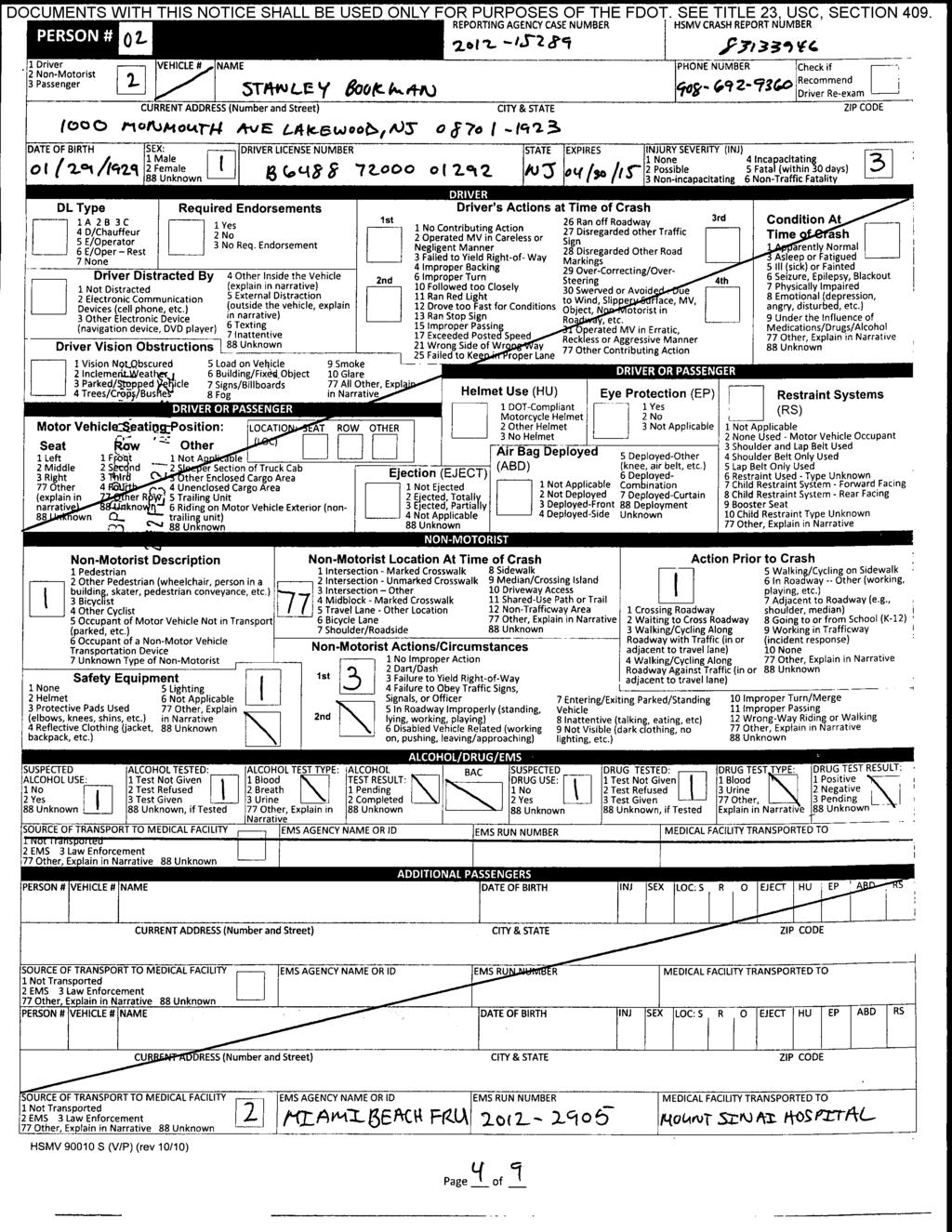
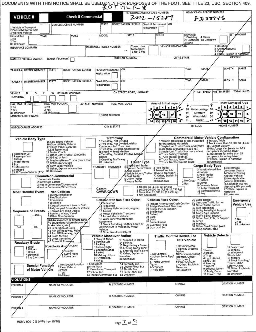
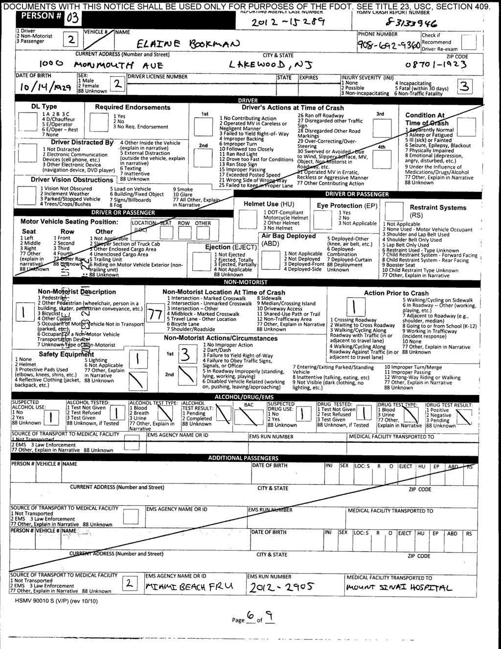
SR 907 (Alton Road) between Barry Street and 41 st Street
|
|
|
- Sophia Allen
- 5 years ago
- Views:
Transcription

1 TWO 20 Pedestrian Safety Study SR 907 (Alton Road) between Barry Street and 41 st Street Miami Beach, Miami-Dade County DRAFT Florida Department of Transportation District VI June 2014
2 TWO 20 Pedestrian Safety Study SR 907 (Alton Road) between Barry Street and 41 st Street Miami Beach, Miami-Dade County Prepared For: Florida Department of Transportation District VI District-Wide Traffic Operations & Safety Studies Contract: C9438 FM No: County: District-Wide FDOT Project Manager: Misleidys Leon, PE June 25, 2014
3 TABLE OF CONTENTS 1. Executive Summary... ii 2. Introduction Existing Conditions Crash Analysis Qualitative Arterial Assessment Conclusions and Recommendations LIST OF FIGURES Figure 1 Site Vicinity Map... 1 Figure 2 Pedestrian crossing the north leg of Alton Rd. and 39 th Street intersection... 5 Figure 3 Pedestrian crosswalk on the east leg of Alton Rd. and 41 st Street intersection... 5 Figure 4 Crash Trends along SR 907 Study Corridor... 8 Figure 5 Potential Mid-Block Crossing Location Figure 6 Existing Pedestrian Signal Head on Southeast Corner of 41 st Street Figure 7 Proposed Crosswalk Realignment on Southwest Corner of 41 st Street LIST OF TABLES Table 1 Summary of Roadway Characteristics... 2 Table 2 Field Observed Pedestrian Clearance Times... 3 Table 3 Summary of Pedestrian/Bicycle Counts... 4 Table 4 Summary of Crash Data SR 907 Study Corridor ( )... 7 Table 5 Recommended Pedestrian Clearance Times LIST OF APPENDICES Appendix A Appendix B Appendix C Appendix D Appendix E Straight Line Diagram Transit Information Pedestrian and Bicycle Counts Crash Data Pedestrian Crash Report June 25, 2014 Page i
4 1. EXECUTIVE SUMMARY This report describes the results of a safety evaluation along the roadway segment of SR 907/Alton Road between Barry Street and 41 st Street/Arthur Godfrey Road (SR 112) and makes recommendations for pedestrian safety improvements. The report includes an evaluation of existing conditions and historical crash rates. An overview of pedestrian collisions is discussed to highlight the need for improvements. The pedestrian safety study was conducted to address concerns raised by the Talmudic University, located west of SR 907/Alton Road with buildings north and south of W 39 th Street, over the safety of school students crossing SR 907/Alton Road. The school has indicated a desire for the implementation of a school zone and crossing improvements at the SR 907/Alton Road and 39 th Street intersection. Currently, there are no pedestrian facilities south of the 41 st Street intersection to facilitate crossings across SR 907/Alton Road. Crossing from the southwest corner of the SR 907/Alton Road at 41 st Street intersection also requires pedestrians to cross a channelized right turn lane before crossing SR 907/Alton Road. The study location is an undivided 4 lane roadway with a posted speed limit of 30 mph. There is one signalized intersection at 41 st Street/Arthur Godfrey Road (SR 112) and two stop-controlled intersections at 39 th Street and Barry Street. At 39 th Street, a total of 8 and 52 pedestrians were observed crossing SR 907/Alton Road during the AM and PM peak one-hour period, respectively. Below are a few historical crash trends observed at the study location: 19 total crashes were reported in the three year study period. One pedestrian crash occurred in 2012 near the 41 st Street intersection No bicycle crashes occurred. Rear-end (37%) and angle (10.5%) were the most prevalent crash types along the segment. Six injury crashes were reported, 32% of total crashes. 0 fatal crashes occurred along the study segment over the three year crash history. Eight crashes occur in dusk, dawn, or dark conditions, 42% of total crashes. 17 of the 19 crashes occurred at the 41 st Street intersection. In order to determine if a pedestrian crosswalk is warranted at SR 907/Alton Road & 39 th Street, Section 3.8 of the FDOT Traffic Engineering Manual (TEM) was reviewed. All criteria under Section 3.8 were met except for criterion (b) under Section 3.8.5(4) which requires the minimum distance to the nearest crossing location to be at least 300 feet. The proposed crosswalk is approximately 270 feet to the nearest crossing location at 41 st Street/Arthur Godfrey Road (SR 112). However, a crosswalk is still recommended at 39 th Street to facilitate a more conspicuous crossing of existing pedestrian activities at this intersection. June 25, 2014 Page ii
5 In summary, the following are recommendations which should be considered to address pedestrian safety issues along the study segment: 1. Segment-wide A reduced speed school zone sign is not warranted based on existing vehicle speeds. Based on our interpretation of the Florida Statute (5), it is also not permitted during the school s dinner break, which represents the peak pedestrian demand period. Therefore, a reduced speed school zone is not recommended along SR 907/Alton Road. 2. SR907/Alton Road and 39 th Street: Install a mid-block crossing on the south leg of the intersection. Implement a no parking at any time zone on the west side of Alton Road between the west leg of 39 th Street and the proposed crosswalk. Construct a raised median to provide a pedestrian refuge for a two stage crossing where the inside northbound through lane is currently located. Conduct further analysis to determine the feasibility of removing one of the two northbound lanes, the extent of the lane removal and geometry of the raised median prior to mid-block crossing construction. Install a Rectangular Rapid Flashing Beacon (RRFB) at the proposed crosswalk location. 3. SR 907/Alton Road and 41 st Street Retime Flashing Don t Walk times for pedestrian signals on the north, south, and west leg of the intersection to provide sufficient crossing time for pedestrians walking at 3.5 ft/sec. The walk interval should also be retimed to ensure that total pedestrian interval accommodates pedestrian crossings at 3 ft/sec. Consider relocating the pedestrian signal head on the southeast corner corresponding to the south leg crosswalk. Also, consider enlarging the channelized right turn lane island to accommodate relocating pedestrian signal heads and push buttons from the southwest corner of the intersection. Realign the crosswalk between the southwest corner of the intersection and the channelized right turn lane island so that crossing pedestrians can better see eastbound right turning vehicles. June 25, 2014 Page iii


6 Alton Road 2. INTRODUCTION A request from the Talmudic University was made to the FDOT District 6 to identify and implement pedestrian safety improvements along SR 907/Alton Road adjacent to the school. A safety study was conducted along the roadway segment of SR 907/Alton Road between Barry Street and 41 st Street/Arthur Godfrey Road (SR 112) in the City of Miami Beach in Miami-Dade County, Florida. The proposed study limits along SR 907/Alton Road are from milepost to 0.181, which covers a distance of approximately 544 feet. Figure 1 illustrates the relative location of the study area to major roadways in the area. A straight line diagram of SR 907/Alton Road is provided in Appendix A. The purpose of this study is to investigate and document the existing conditions of pedestrian movements along the study corridor and to provide recommendations regarding the need for pedestrian crossings. Concerns were raised by the Talmudic University over the safety of University students crossing SR 907/Alton Road along the study segment. School officials have also expressed a desire for the implementation of a school zone on SR 907/Alton Road and crossing improvements at SR 907/Alton Road and 39 th Street. Currently, there are no pedestrian facilities to help cross Alton Road at 39 th Street. This study will place a special emphasis on pedestrian treatments, specifically mid-block crossings, which could be implemented to provide a safe crossing for pedestrians. 39 th Street Figure 1 Site Vicinity Map June 25, 2014 Page 1
7 3. EXISTING CONDITIONS The existing conditions analysis identified site conditions and the current geometric characteristics of the roadway segment of SR 907/Alton Road between Barry Street and 41 st Street/Arthur Godfrey Road (SR 112). Field reviews were conducted on March 11, 2014 to document day and evening conditions and to observe pedestrian activity at the study location. Table 1 provides a summary of the roadway segment characteristics for SR 907/Alton Road between Barry Street and 41 st Street/Arthur Godfrey Road (SR 112). Table 1 Summary of Roadway Characteristics Characteristic Segment Value Segment Limits: Milepost to Study Segment Length: Area Type: Segment Cross-section: Posted Speed Limit: Average Annual Daily Traffic: Functional Classification: miles Urban Undivided 4-lane roadway 30 miles per hour (mph) on Alton Road 6,800 vehicles/day on Alton Road Urban Minor Arterial Access Classification: 5 Pedestrian Facilities: Bicycle Facilities: Transit Service/Facilities: Lighting: Drainage: Parking: Sidewalks are present along Alton Road in both directions. Crosswalks are present on all legs of the Alton Road and 41 st Street intersection. The intersection also has countdown pedestrian signals and push buttons. Crosswalks are also present along Alton Road at 39 th Street and Barry Street for the north-south movements, except on the west leg of 39 th Street. There are no crosswalks across Alton Road south of the 41 st Street intersection. None Miami-Dade Transit routes 103, 113, 115, and 117 travel along SR 907/Alton Road at approximately 10 minute intervals; benches are provided at the bus stops Conventional lighting with cobra head luminaries Curb inlets, manholes, and storm pipes On-street parking along SR 907/Alton Road 3.1 Project Background The pedestrian safety study was conducted to address concerns raised by the Talmudic University over the safety of school students crossing SR 907/Alton Road. The school has indicated a desire for the implementation of a school zone and crossing improvements at the SR 907/Alton Road and 39 th Street intersection. Currently, there are no pedestrian facilities south of the 41 st Street intersection to facilitate crossings across SR 907/Alton Road. Crossing from the southwest corner of the SR 907/Alton Road at 41 st Street intersection also requires pedestrians to cross a channelized right turn lane before crossing SR 907/Alton Road. Within the study area, commercial land uses are predominant east of SR 907/Alton Road between 39 th Street and 41 st Street/Arthur Godfrey Road (SR 112). Directly opposite June 25, 2014 Page 2
8 the Talmudic University on the east side of SR 907/Alton Road is the parking lot for Saint Patrick s Parish School. Miami-Dade Transit operates bus routes 103, 113, 115 and 117 along SR 907/Alton Road and has bus stops on both sides of the roadway approximately 20 feet south of the 39 th Street intersection. Miami-Dade Transit bus schedules are provided in Appendix B. 3.2 Roadway Geometry SR 907/Alton Road is an undivided urban minor arterial with two 11-feet travel lanes in each direction. 8-foot on-street parking is located on both sides of the roadway. Currently, there are no bicycle lanes along SR 907/Alton Road. The posted speed limit along SR 907/Alton Road is 30 mph. Field reviews observed vehicular travel speeds along SR 907/Alton Road to be between 20 and 30 mph. 3.3 Pedestrian Facilities Sidewalks are present along both sides of the SR 907/Alton Road study segment. There are high visibility crosswalks along Alton Road in the north-south direction at 39 th Street and Barry Street, except on the west leg of 39 th Street. These high visibility crosswalks are painted red stamped asphalt. Sidewalks are present along all four legs of the 41 st Street intersection and high visibility crosswalks are present on the south, east, and west legs. The SR 907/Alton Road and 41 st Street intersection has countdown pedestrian signals and pedestrian push buttons. Presently, there are no crosswalks to facilitate pedestrian crossings across SR 907/Alton Road south of the 41 st Street/Arthur Godfrey Road (SR 112) intersection. A field review of the crossing times at the 41 st Street intersection was conducted. See Table 2 for existing Flashing Don t Walk (FDW) times. Table 2 Field Observed Pedestrian Clearance Times Crosswalk Flashing Don't Walk Times (sec) West Leg 27 East Leg 26 South Leg 14 North Leg Pedestrian Activities During the morning and evening field review of the study location, the majority of school-related crossings occurred at SR 907/Alton Road and at 39 th Street between the Talmudic University and the commercial land uses on the east side of the roadway. Pedestrian counts were taken at the study location on March 18, 2014 in order to quantify the number of pedestrian crossings during the AM and PM peak hours, 8:00 to 10:00 AM and 6:00 to 8:00 PM. June 25, 2014 Page 3
9 Table 3 is a summary of the pedestrian/bicycle counts at the intersection. The raw pedestrian/bicycle counts are provided in Appendix C. Table 3 Summary of Pedestrian/Bicycle Counts Pedestrian/Bicycle Volume (Total # of Pedestrians/Cyclists) Crosswalk SR 907 & Barry Street* SR 907 & 39th Street* SR 907 & SR 112 AM (8:00-10:00) PM (6:00-8:00) AM (8:00-10:00) PM (6:00-8:00) AM (8:00-10:00) PM (6:00-8:00) West Leg East Leg South Leg North Leg Totals * Note: Study location has no crosswalks across SR 907/Alton Road In addition to the total number of pedestrians/bicyclists reported in Table 3, pedestrian group data was also collected and is summarized below: SR 907/Alton Road & SR 112/Arthur Godfrey Road o 10 two-person groups; and o 5 three-person groups SR 907/Alton Road & 39 th Street o 30 two-person groups; o 5 three-person groups; and o 7 four-person or larger groups SR 907/Alton Road & Barry Street o 1 three-person group Figure 2 and Figure 3 show the pedestrian activity observed during the field review. June 25, 2014 Page 4


10 Figure 2 Pedestrian crossing the north leg of Alton Rd. and 39 th Street intersection Figure 3 Pedestrian crosswalk on the east leg of Alton Rd. and 41 st Street intersection June 25, 2014 Page 5
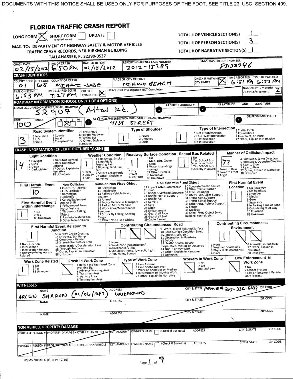
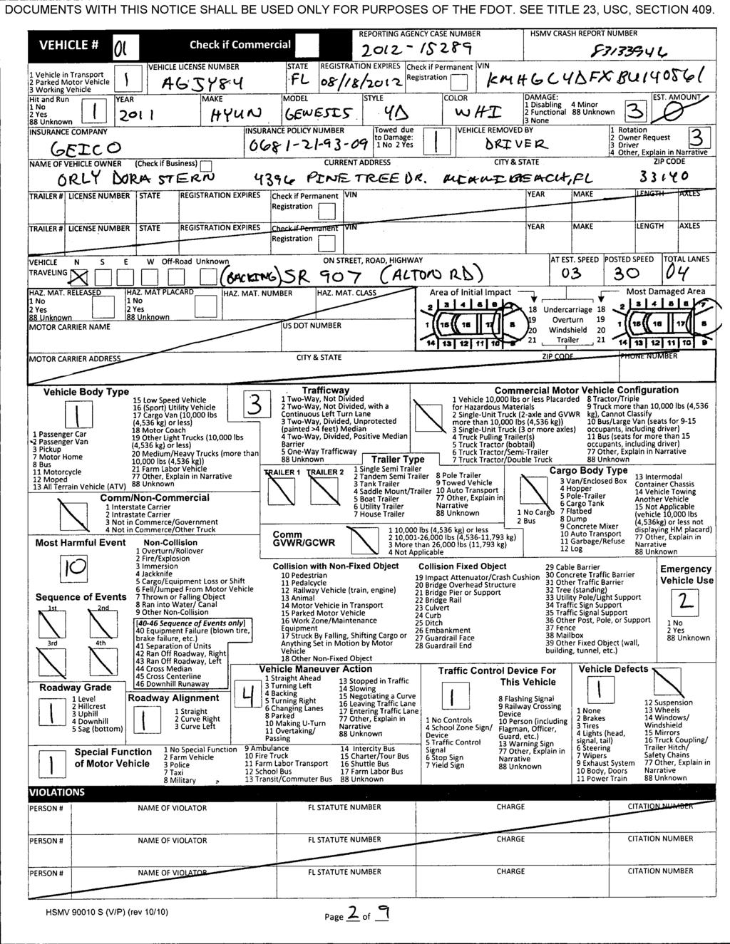
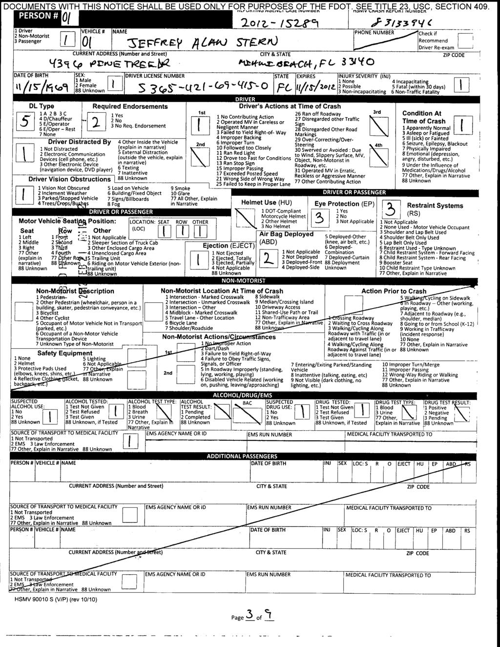
11 4. CRASH ANALYSIS The most current three years of crash data (2010 to 2012) was obtained from FDOT Crash Analysis Reporting System (CAR) and reviewed. The review included an evaluation of crash trends and pedestrian/bicycle related crashes, which were summarized in detail, if any occurred. 4.1 Historical Crash Trends The crash data for the SR 907/Alton Road study segment is summarized in Table 4. The crash history was reviewed to determine if patterns or trends can be identified that indicate opportunities to reduce pedestrian and bicyclist crash frequency or severity. The primary trends observed are: 19 total crashes were reported in the three year study period. One pedestrian crash occurred in 2012 near the 41 st Street intersection. No bicycle crashes occurred. Rear-end (37%) and angle (10.5%) were the most prevalent crash types along the segment. Six injury crashes were reported, 32% of total crashes. 0 fatal crashes occurred along the study segment over the three year crash history. Eight crashes occur in dusk, dawn or dark conditions, 42% of total crashes. 17 of the 19 crashes occurred at the 41 st Street intersection. Figure 4 illustrates the crash trends for the study location. Appendix D contains the original crash output file from the CAR system for the segment. 4.2 Pedestrian Crash Summary The single pedestrian related crash, which occurred at the intersection of SR 907/Alton Road with 41 st Street, is summarized below. The pedestrian crash report can be found in Appendix E. On February 15, 2012 at 6:51 PM a pedestrian-related collision occurred on the southbound travel lanes of SR 907/Alton Road approximately 100 feet south of 41 st Street. There were dry pavement, clear weather, and dark-lighted lighting conditions. A vehicle was backing into an available parking space when two pedestrians crossed the roadway onto SR 907/Alton Road from the sidewalk. The vehicle struck one of the pedestrians to the ground with its rear end. As a result of the impact, the pedestrian struck the other pedestrian onto the ground. The pedestrians were transported to Mount Sinai Hospital for possible injuries. June 25, 2014 Page 6
12 Table 4 Summary of Crash Data SR 907 Study Corridor ( ) SR 907 from Barry St. to 41 st St. Crash Type Severity Lighting Conditions Surface Condition Month Day of Week Time of Day Number of Crashes per Year 3-Year Total Crashes Mean Crashes Per Year % of 3-Year Total Rear End % Head On % Angle % Left Turn % Right Turn % Sideswipe % Backed Into % Collision w/ Parked Car % Collision w/ Pedestrian % Collision w/ Bicycle % Fixed Object % Ran Off Road % Overturned % Other % Total Crashes % PDO Crashes % Fatal Crashes % Injury Crashes % Daylight % Dusk % Dawn % Dark % Unknown % Dry % Wet % Other % January % February % March % April % May % June % July % August % September % October % November % December % Monday % Tuesday % Wednesday % Thursday % Friday % Saturday % Sunday % 00:00-06: % 06:00-09: % 09:00-11: % 11:00-13: % 13:00-15: % 15:00-18: % 18:00-24: % June 25, 2014 Page 7
13 Figure 4 Crash Trends along SR 907 Study Corridor June 25, 2014 Page 8
14 5. QUALITATIVE ARTERIAL ASSESSMENT The qualitative assessment presented in this section discusses the research performed and provides considerations/recommendations for pedestrian improvements along the study segment. 5.1 Pedestrian Crosswalk at 39 th Street In order to determine mid-block crossing applicability at 39 th Street, the FDOT TEM Section 3.8 was reviewed. In Section 3.8.5(2), the FDOT Traffic Engineering Manual (TEM) states that for a mid-block pedestrian crosswalk to be considered, it shall meet all the criteria in Sections 3.8.5(3) and 3.8.5(4). Those criteria are summarized below: Section 3.8.5(3) Minimum Levels of Pedestrian Demand o (a) Location under consideration should exhibit a well-defined spatial pattern of pedestrian generators or a well-defined pattern of existing crossings. Condition met o (b) Sufficient demand should exist that meets or exceeds the thresholds for three consecutive days of data collection: Minimum of 20 pedestrians during any hour. Condition met in PM-peak hour (52 pedestrians in one hour) Minimum of 60 pedestrians during any four hours of the day, not necessarily consecutive hours. Condition met during 4 hour data collection period (82 pedestrians) Section 3.8.5(4) Minimum Location Characteristics o (a) Minimum roadway volume of 2,000 Average Daily Traffic (ADT). Condition met o (b) Minimum distance to nearest crossing location is 300 feet. Condition not met, distance to 41 st Street is 270 feet. o (c) If the proposed location is between intersections, the minimum block length is 660 feet. Not Applicable o (d) The proposed location must be outside the influence area of adjacent signalized intersections. Condition met June 25, 2014 Page 9

15 SR 907/Alton Road Based on the review of Section 3.8 in the TEM and existing field conditions at the study location, a pedestrian mid-block crossing is recommended at 39 th Street. The following are recommendations which should be considered to address pedestrian safety issues at 39 th Street: 1. A mid-block crosswalk at SR 907/Alton Road and 39 th Street is warranted based on pedestrian demand outlined in Section 3.8.5(3). The University and adjacent commercial land uses were identified as pedestrian generators and attractors. A well-defined pattern of existing pedestrian crossings was also identified based on data collection. A crosswalk should be installed on the south leg of the 39 th Street intersection, as displayed in Figure 5. A no parking zone at any time zone should be implemented on the west side of Alton Road within the vicinity of the proposed crosswalk. The crosswalk is proposed on the south leg instead of the north leg to provide additional distance between the closest adjacent crosswalk on the south leg of the 41 st Street intersection and provide the spatial requirements needed to install a raised median and pedestrian refuge. 39 th Street Figure 5 Potential Mid-Block Crossing Location 2. A raised median should be constructed to provide space for a refuge for pedestrians crossing SR 907/Alton Road. This refuge between the northbound and southbound travel lanes will provide a two-stage crossing for pedestrians. The northbound approach may have to be reconfigured from two lanes to one lane. Removing the northbound left turn lane is expected to have minimal impact since the Talmudic University driveway on the west leg in a one-way eastbound approach and field reviews did not suggest traffic volumes to warrant two northbound lanes at 39 th Street. A northbound left turn ingress will also need to be provided on the southern driveway of the Talmudic University, south of the 39 th Street intersection. June 25, 2014 Page 10
16 Further analysis is recommended to determine the feasibility of removing one of the two northbound lanes, the extent of the lane removal and geometry of the raised median prior to mid-block crossing construction. 3. Install a Rectangular Rapid Flashing Beacon (RRFB) at the proposed crosswalk on the south leg of the 39 th Street intersection to increase road user awareness and yield rates to pedestrians. Although the proposed crosswalk does not meet the minimum distance to the nearest crosswalk of 300 feet as stated in Section 3.8.5(4) of the TEM, pedestrian counts conducted during the AM and PM-peak hour periods reveal sufficient pedestrian demand to warrant a crosswalk. Therefore, it is recommended that a crosswalk should be installed at 39 th Street to facilitate a more conspicuous crossing across SR 907/Alton Road even though the proposed crosswalk is approximately 30 feet below the required minimum distance from the crosswalk at 41 st Street, as recommended in the TEM. 5.2 Establishing a Reduced Speed School Zone One of the Talmudic University s requests is to evaluate the effectiveness of establishing a reduced speed school zone along SR 907/Alton Road in the vicinity of the university. This section provides the findings from the search of guidelines relevant to the establishment of reduced speed school zones along SR 907/Alton Road. FDOT conducted a study 1 in June, 2009 to evaluate the effectiveness of reduced speed school zones at marked crossing locations along state highways, and whether their effectiveness is dependent on other factors. The results of the study were based on a comprehensive literature review, online surveys to school safety professionals, site analysis, crash data analysis, and evaluation of relevant transportation features. The study did not find a direct correlation between lower pedestrian crash rates and reduced speed school zones. The survey findings indicate that reduced speed school zones are perceived to enhance safety at school crossing locations since they provide an increase in the available reaction time for the drivers in case of an incident with a pedestrian. Also, the severity of the crashes has been previously proven to be reduced when vehicles are driving at lower speeds. Nonetheless, the study states that the provision of a reduced speed environment was observed to encourage jaywalking activities among high school students. Generally, a higher number of crashes occur when the speed differential is greatest. The use of unrealistically low speed limits usually results in high violation rates and large variance in speed, which negates speed zoning. It is also suggested by the authors of the study that the implementation of a reduced speed school zone could potentially result in a congestion increase and rear-end, headon, or sideswipe crashes. 1 Study of School Zones with Traffic Signals prepared by Cambridge Systematics, Inc. and Kittelson & Associates, Inc. in June FDOT Contract Number: C8L13 June 25, 2014 Page 11
17 The study conducted in 2009 recommends considering the installation of a reduced speed school zone if the 85 th percentile speed measured outside of school opening and closing times exceeds 55 mph. Field observations suggested that vehicle speeds were approximately 20 to 30 mph along SR 907/Alton Road outside the Talmudic University. Therefore, the reduced speed school zone would not be justified for the observed driving speeds. The current standards shown in the MUTCD and the adopted Florida Statutes (Rule ) do not provide standards for the provision of reduced speed school zones. Both documents indicate that these treatments may be considered if a traffic engineering study justifies their installation. Crash experience, pedestrian crossing volume, pedestrian crossing distance, sight-distance, and traffic speed are recommended conditions to be evaluated prior the implementation of a reduced speed school zone. Some Florida counties condition the installation of a reduced speed school zone on the school crosswalk signalization. School crossing guards have been identified to increase safety in the vicinity of the school crossings, and may preclude the need for further pursuit of a reduced speed school zone. Per Florida Statute (5), a school zone speed limit may not be less than 15 miles per hour except by local regulation. No school zone speed limit shall be more than 20 miles per hour in an urbanized area, as defined in Section Such speed limit may be in force only during those times 30 minutes before, during, and 30 minutes after the periods of time when pupils are arriving at a regularly scheduled breakfast program or a regularly scheduled school session and leaving a regularly scheduled school session. The Talmudic University has a non-typical start and dismissal time of 9:15 AM and 10:00 PM respectively, with the peak pedestrian demand occurring during the dinner break from 6:30 PM to 8:00 PM. It is our interpretation that a dinner break does not fall in the category of leaving a regularly scheduled school session. Therefore, a reduced speed school zone is not recommended outside the Talmudic University. Overall, a reduced speed school zone is not recommended along SR 907/Alton Road outside the Talmudic University. Field observations do not suggest that the 85 th percentile vehicle speed outside the Talmudic University exceeds 55 mph as recommended by FDOT as criteria for school zone implementation. Furthermore, the peak pedestrian demand outside the Talmudic University occurs during school s dinner break, which is not an eligible time period for an active reduced speed school zone based on our interpretation of the statute. 5.3 Recommendations at 41 st Street The following are additional recommendations that should be considered to address pedestrian safety issues identified during the field review at 41 st Street: 1. The Flashing Don t Walk (FDW) times for the crosswalks on the north, south and west leg of SR 907/Alton Road and 41 st Street intersection should be retimed to accommodate the 3.5 ft/sec pedestrian clearance time specified in Section 4E.06(07) of the MUTCD. See Table 5 for June 25, 2014 Page 12
 of the MUTCD.")
18 recommended Flashing Don t Walk times. The walk interval should also be retimed to ensure that total pedestrian interval accommodate pedestrian crossing at 3 ft/sec as specified in Section 4E.06(14) of the MUTCD. It is also recommended the pedestrian signal head on the southeast corner corresponding to the eastbound pedestrian movement be relocated to the end of the crosswalk to provide better visibility along the pedestrian crossing path (see Figure 6 for existing location). Similarly, it is recommended the pedestrian signal heads and push button on the southwest corner be relocated to the raised right turn island. This should provide better visibility for pedestrians crossing westbound across SR 907/Alton Road along the south crosswalk. The turn lane island may need to be enlarged to provide adequate spatial separation between the pedestrian signal heads. Table 5 Recommended Pedestrian Clearance Times Crosswalk Field Observed Flashing Don't Walk Times (sec) Minimum Required* West Leg East Leg South Leg North Leg * Minimum required time based on MUTCD Section 4E.06(07) and field measured crossing distances Poor visibility of pedestrian signal head Figure 6 Existing Pedestrian Signal Head on Southeast Corner of 41 st Street 2. The crosswalk between the southwest corner of the intersection and the raised right turn island at SR 907/Alton Road and 41 st Street should be realigned so it is perpendicular to eastbound right turning vehicles, as shown in Figure 7. Currently, pedestrians crossing the channelized right turn lane are not positioned to face oncoming vehicles. Realigning the June 25, 2014 Page 13

19 crosswalk would provide improve visibility of oncoming vehicles for pedestrians crossing the channelized right turn lane. Figure 7 Proposed Crosswalk Realignment on Southwest Corner of 41 st Street June 25, 2014 Page 14
20 6. CONCLUSIONS AND RECOMMENDATIONS Based on the review of Section 3.8 in the TEM and existing field conditions at the study location, a pedestrian mid-block crossing is recommended on the south leg at the 39 th Street intersections. In summary, the following are recommendations which should be considered to address pedestrian safety issues along the study segment: 1. Segment-wide A reduced speed school zone sign is not warranted based on existing vehicle speeds. Based on our interpretation of the Florida Statute (5), it is also not permitted during the school s dinner break, which represents the peak pedestrian demand period. Therefore, a reduced speed school zone is not recommended along SR 907/Alton Road. 2. SR907/Alton Road and 39 th Street: Install a mid-block crossing on the south leg of the intersection. Implement a no parking at any time zone on the west side of Alton Road between the west leg of 39 th Street and the proposed crosswalk. Construct a raised median to provide a pedestrian refuge for a two stage crossing where the inside northbound through lane is currently located. Conduct further analysis to determine the feasibility of removing one of the two northbound lanes, the extent of the lane removal and geometry of the raised median prior to mid-block crossing construction. Install a Rectangular Rapid Flashing Beacon (RRFB) at the proposed crosswalk location. 3. SR 907/Alton Road and 41 st Street Retime Flashing Don t Walk times for pedestrian signals on the north, south, and west leg of the intersection to provide sufficient crossing time for pedestrians walking at 3.5 ft/sec. The walk interval should also be retimed to ensure that total pedestrian interval accommodates pedestrian crossings at 3 ft/sec. Consider relocating the pedestrian signal head on the southeast corner corresponding to the south leg crosswalk. Also, consider enlarging the channelized right turn lane island to accommodate relocating pedestrian signal heads and push buttons from the southwest corner of the intersection. Realign the crosswalk between the southwest corner of the intersection and the channelized right turn lane island so that crossing pedestrians can better see eastbound right turning vehicles. June 25, 2014 Page 15
21 Appendix A Straight Line Diagram
22
23 Appendix B Transit Information
24 Route C Adrienne Arsht Center Metromover Station/ Bus Terminal 44 St Downtown Bus Terminal Flagler St 1 Ave N. Miami Ct NE14 St NE 2 Ave NE 1 St SW/SE 1 St Biscayne Blvd Bayshore Dr NE 3 St 13 St Downtown Miami Mt. Sinai Medical Center Alton Rd Miami Beach 41 St Indian Creek Dr Collins Ave C ollins Ave Adrienne Arsht Center Metromover Station/ Bus Terminal 13 St Jungle Island Lincoln Rd Mall 17 St Lincoln Rd Miami Beach Miami Children s Museum MacArthur Causeway NORTH MAP NOT TO SCALE St Washington Ave South Beach
25 Routes Schedule - Miami-Dade County Page 1 of 2 4/29/2014 Miami-Dade County Miami-Dade Transit Routes Schedule 103 Route C Schedule Back to previous page (javascript: history.go(-1) ) Service: Weekday Direction: Northbound CBD TERMINAL & SW 1 AV OP FEDERAL B OMNI TERMINAL & BISCAYNE BLVD 5 ST & LENOX AV LINCOLN RD & WASHINGTON AV 41 ST & INDIAN CREEK DR MT SINAI HOSPITAL & MAIN DOOR ALTON RD & 39 ST 04:59AM 05:08AM 05:15AM 05:25AM 05:32AM 05:40AM 05:42AM 05:19AM 05:28AM 05:35AM 05:45AM 05:52AM 06:02AM 06:04AM 05:40AM 05:49AM 05:56AM 06:08AM 06:16AM 06:26AM 06:28AM 06:00AM 06:12AM 06:20AM 06:32AM 06:40AM 06:50AM 06:52AM 06:20AM 06:32AM 06:40AM 06:52AM 07:00AM 07:11AM 07:13AM 06:40AM 06:52AM 07:00AM 07:13AM 07:21AM 07:32AM 07:34AM 07:00AM 07:13AM 07:21AM 07:34AM 07:42AM 07:53AM 07:55AM 07:20AM 07:33AM 07:41AM 07:54AM 08:04AM 08:15AM 08:17AM 07:40AM 07:53AM 08:01AM 08:14AM 08:24AM 08:35AM 08:37AM 08:00AM 08:13AM 08:21AM 08:34AM 08:44AM 08:55AM 08:57AM 08:20AM 08:33AM 08:41AM 08:54AM 09:06AM 09:18AM 09:20AM 08:40AM 08:53AM 09:02AM 09:17AM 09:29AM 09:41AM 09:43AM 09:00AM 09:15AM 09:24AM 09:39AM 09:51AM 10:03AM 10:05AM 09:20AM 09:35AM 09:44AM 09:59AM 10:11AM 10:23AM 10:25AM 09:40AM 09:55AM 10:04AM 10:19AM 10:31AM 10:43AM 10:45AM 10:00AM 10:15AM 10:24AM 10:39AM 10:51AM 11:03AM 11:05AM 10:20AM 10:35AM 10:44AM 10:59AM 11:11AM 11:23AM 11:25AM 10:40AM 10:55AM 11:04AM 11:19AM 11:31AM 11:43AM 11:45AM 11:00AM 11:15AM 11:24AM 11:39AM 11:51AM 12:03PM 12:05PM 11:25AM 11:40AM 11:49AM 12:04PM 12:16PM 12:28PM 12:30PM 11:45AM 12:00PM 12:09PM 12:24PM 12:36PM 12:48PM 12:50PM 12:05PM 12:20PM 12:29PM 12:44PM 12:56PM 01:08PM 01:10PM 12:25PM 12:40PM 12:49PM 01:04PM 01:16PM 01:28PM 01:30PM 12:45PM 01:00PM 01:09PM 01:24PM 01:36PM 01:48PM 01:50PM 01:05PM 01:20PM 01:29PM 01:44PM 01:56PM 02:08PM 02:10PM
26 Routes Schedule - Miami-Dade County Page 2 of 2 4/29/ :25PM 01:40PM 01:49PM 02:04PM 02:16PM 02:28PM 02:30PM 01:40PM 01:55PM 02:04PM 02:19PM 02:31PM 02:43PM 02:45PM 02:00PM 02:15PM 02:24PM 02:39PM 02:51PM 03:03PM 03:05PM 02:20PM 02:35PM 02:44PM 02:59PM 03:11PM 03:23PM 03:25PM 02:40PM 02:55PM 03:04PM 03:19PM 03:31PM 03:43PM 03:45PM 03:00PM 03:15PM 03:24PM 03:39PM 03:51PM 04:04PM 04:06PM 03:20PM 03:35PM 03:44PM 03:59PM 04:11PM 04:24PM 04:26PM 03:40PM 03:55PM 04:04PM 04:19PM 04:29PM 04:42PM 04:44PM 04:00PM 04:16PM 04:25PM 04:40PM 04:50PM 05:03PM 05:05PM 04:20PM 04:36PM 04:45PM 05:00PM 05:10PM 05:23PM 05:25PM 04:40PM 04:56PM 05:05PM 05:20PM 05:30PM 05:43PM 05:45PM 05:00PM 05:16PM 05:25PM 05:40PM 05:50PM 06:03PM 06:05PM 05:20PM 05:36PM 05:45PM 06:00PM 06:10PM 06:23PM - 05:40PM 05:56PM 06:05PM 06:20PM 06:30PM 06:43PM 06:45PM 06:00PM 06:16PM 06:25PM 06:40PM 06:50PM 07:03PM - 06:20PM 06:36PM 06:45PM 07:00PM 07:08PM 07:19PM 07:21PM 06:40PM 06:56PM 07:05PM 07:18PM 07:26PM 07:37PM 07:39PM 07:00PM 07:13PM 07:21PM 07:34PM 07:42PM 07:53PM - 07:32PM 07:45PM 07:53PM 08:06PM 08:14PM 08:25PM 08:27PM 08:02PM 08:15PM 08:23PM 08:36PM 08:44PM 08:55PM 08:57PM 08:32PM 08:45PM 08:53PM 09:06PM 09:14PM 09:25PM - 09:02PM 09:15PM 09:23PM 09:36PM 09:44PM 09:55PM 09:57PM 09:34PM 09:47PM 09:55PM 10:08PM 10:15PM 10:24PM - 10:15PM 10:25PM 10:33PM 10:45PM 10:52PM 11:01PM - 11:15PM 11:25PM 11:33PM 11:45PM 11:52PM 12:01AM - 12:12AM 12:21AM 12:29AM 12:39AM 12:46AM 12:54AM - Back to previous page (javascript: history.go(-1) ) Page Last Edited: Mon Apr 21, :25:27 AM
27 Routes Schedule - Miami-Dade County Page 1 of 3 4/29/2014 Miami-Dade County Miami-Dade Transit Routes Schedule 103 Route C Schedule Back to previous page (javascript: history.go(-1) ) Service: Weekday Direction: Southbound ALTON RD & 39 ST MT SINAI HOSPITAL & MAIN DOOR INDIAN CREEK DR & 41 ST WASHINGTON AV & LINCOLN RD 5 ST & LENOX AV OMNI TERMINAL & BISCAYNE BLVD CBD TERMINAL & SW 1 AV OP FEDERAL B :51AM 05:01AM 05:07AM 05:17AM :12AM 05:22AM 05:28AM 05:38AM - 05:19AM 05:26AM 05:32AM 05:42AM 05:48AM 05:58AM - 05:35AM 05:42AM 05:48AM 05:58AM 06:05AM 06:18AM 05:49AM 05:52AM 05:59AM 06:06AM 06:18AM 06:25AM 06:38AM 06:09AM 06:12AM 06:19AM 06:26AM 06:38AM 06:45AM 06:58AM - 06:30AM 06:37AM 06:44AM 06:56AM 07:04AM 07:18AM 06:44AM 06:47AM 06:54AM 07:03AM 07:16AM 07:24AM 07:38AM 07:02AM 07:05AM 07:14AM 07:23AM 07:36AM 07:44AM 07:58AM 07:22AM 07:25AM 07:34AM 07:43AM 07:56AM 08:04AM 08:18AM - 07:44AM 07:53AM 08:03AM 08:16AM 08:24AM 08:38AM 08:00AM 08:03AM 08:13AM 08:23AM 08:36AM 08:44AM 08:58AM 08:17AM 08:20AM 08:30AM 08:40AM 08:53AM 09:03AM 09:18AM 08:35AM 08:38AM 08:48AM 08:58AM 09:13AM 09:23AM 09:38AM 08:52AM 08:55AM 09:07AM 09:18AM 09:33AM 09:43AM 09:58AM 09:12AM 09:15AM 09:27AM 09:38AM 09:53AM 10:03AM 10:18AM 09:32AM 09:35AM 09:47AM 09:58AM 10:13AM 10:23AM 10:38AM 09:52AM 09:55AM 10:07AM 10:18AM 10:33AM 10:43AM 10:58AM 10:17AM 10:20AM 10:32AM 10:43AM 10:58AM 11:08AM 11:23AM 10:37AM 10:40AM 10:52AM 11:03AM 11:18AM 11:28AM 11:43AM 10:57AM 11:00AM 11:12AM 11:23AM 11:38AM 11:48AM 12:03PM 11:17AM 11:20AM 11:32AM 11:43AM 11:58AM 12:08PM 12:23PM 11:37AM 11:40AM 11:52AM 12:03PM 12:18PM 12:28PM 12:43PM 11:57AM 12:00PM 12:12PM 12:23PM 12:38PM 12:48PM 01:03PM 12:17PM 12:20PM 12:32PM 12:43PM 12:58PM 01:08PM 01:23PM
28 Routes Schedule - Miami-Dade County Page 2 of 3 4/29/ :35PM 12:47PM 12:58PM 01:13PM 01:23PM 01:38PM 12:52PM 12:55PM 01:07PM 01:18PM 01:33PM 01:43PM 01:58PM 01:12PM 01:15PM 01:27PM 01:38PM 01:53PM 02:03PM 02:18PM 01:32PM 01:35PM 01:47PM 01:58PM 02:13PM 02:23PM 02:38PM 01:52PM 01:55PM 02:07PM 02:18PM 02:33PM 02:43PM 02:58PM 02:12PM 02:15PM 02:27PM 02:38PM 02:53PM 03:03PM 03:18PM 02:32PM 02:35PM 02:47PM 02:58PM 03:13PM 03:23PM 03:38PM 02:52PM 02:55PM 03:07PM 03:18PM 03:33PM 03:43PM 03:58PM 03:12PM 03:15PM 03:27PM 03:38PM 03:53PM 04:03PM 04:18PM 03:32PM 03:35PM 03:47PM 03:58PM 04:13PM 04:23PM 04:38PM 03:52PM 03:55PM 04:07PM 04:18PM 04:33PM 04:43PM 04:58PM 04:11PM 04:15PM 04:27PM 04:38PM 04:53PM 05:03PM 05:18PM 04:31PM 04:35PM 04:47PM 04:58PM 05:13PM 05:23PM 05:38PM 04:51PM 04:55PM 05:07PM 05:18PM 05:33PM 05:43PM 05:58PM 05:11PM 05:15PM 05:27PM 05:38PM 05:53PM 06:03PM 06:18PM 05:31PM 05:35PM 05:47PM 05:58PM 06:13PM 06:23PM 06:38PM 05:51PM 05:55PM 06:07PM 06:18PM 06:33PM 06:43PM 06:58PM 06:10PM 06:14PM 06:26PM 06:37PM 06:52PM 07:02PM 07:16PM 06:26PM 06:30PM 06:42PM 06:53PM 07:08PM 07:16PM 07:30PM 07:03PM 07:06PM 07:16PM 07:25PM 07:38PM 07:46PM 08:00PM 07:33PM 07:36PM 07:46PM 07:55PM 08:08PM 08:16PM 08:30PM 08:03PM 08:06PM 08:16PM 08:25PM 08:38PM 08:46PM 09:00PM 08:35PM 08:38PM 08:48PM 08:57PM 09:10PM 09:18PM 09:32PM 09:05PM 09:08PM 09:18PM 09:27PM 09:40PM 09:48PM 10:02PM 10:10PM 10:13PM 10:22PM 10:30PM 10:42PM 10:49PM 11:00PM - 11:06PM 11:15PM 11:23PM 11:35PM 11:42PM 11:53PM - 12:06AM 12:13AM 12:19AM 12:29AM 12:35AM 12:45AM Back to previous page (javascript: history.go(-1) ) Page Last Edited: Mon Apr 21, :25:27 AM
29 Routes Schedule - Miami-Dade County Page 3 of 3 4/29/2014
30 13 Terr NW River Dr Bob Hope Dr METRORAIL Route M 14 St N Bayshore Dr NW 20 St NW 17 St NW/NE 14 St NW 3 Ave NW 12 Ave NW 10 Ave Adrienne Arsht Center Metromover Station/ Bus Terminal Miami Children s Museum 19 Ave 17 Ave Civic Center NW 21 St Metrorail Station VA Hospital Jackson Memorial Hospital MIAMI NORTH MAP NOT TO SCALE MacArthur Causeway Jungle Island 17 St 5 St Lincoln Rd South Pointe Dr. Alton Rd Washington Ave Collins Ave Alton Rd Mt. Sinai Medical Center MIAMI BEACH SOUTH BEACH Indian Creek Dr 41 St Collins Ave 44 St

31 Routes Schedule - Miami-Dade County Page 1 of 2 4/29/2014 Miami-Dade County Miami-Dade Transit Routes Schedule 113 Route M Schedule Back to previous page (javascript: history.go(-1) ) Service: Weekday Direction: Eastbound NW 21 ST & NW 19 AV NW 12 AV & NW 15 ST OMNI TERMINAL & BISCAYNE BLVD ALTON RD & 2 ST 5 ST & LENOX AV ALTON RD & LINCOLN RD MALL LINCOLN RD & JAMES AV 41 ST & INDIAN CREEK DR 41 ST & MERIDIAN AV 41 ST & ALTON RD MT SINAI HOSPITAL & MAIN DOOR ALTON RD & 39 ST 05:42AM 05:48AM 05:58AM 06:08AM 06:13AM 06:21AM 06:26AM 06:35AM 06:42AM 06:43AM 06:45AM 06:47AM 06:20AM 06:27AM 06:39AM 06:49AM 06:54AM 07:04AM 07:10AM 07:20AM 07:27AM 07:29AM 07:31AM 07:33AM 06:55AM 07:03AM 07:16AM 07:27AM 07:33AM 07:43AM 07:49AM 07:59AM 08:06AM 08:08AM 08:10AM 08:12AM 07:45AM 07:53AM 08:06AM 08:17AM 08:23AM 08:33AM 08:39AM 08:51AM 08:58AM 09:00AM 09:02AM 09:04AM 08:30AM 08:38AM 08:51AM 09:02AM 09:08AM 09:18AM 09:25AM 09:37AM 09:44AM 09:46AM 09:48AM 09:50AM 09:15AM 09:23AM 09:37AM 09:48AM 09:54AM 10:04AM 10:11AM 10:23AM 10:30AM 10:32AM 10:34AM - 09:55AM 10:03AM 10:17AM 10:28AM 10:34AM 10:44AM 10:51AM 11:03AM 11:10AM 11:12AM 11:14AM - 10:55AM 11:03AM 11:17AM 11:28AM 11:34AM 11:44AM 11:51AM 12:03PM 12:10PM 12:12PM 12:14PM - 11:55AM 12:03PM 12:17PM 12:28PM 12:34PM 12:44PM 12:51PM 01:03PM 01:10PM 01:12PM 01:14PM - 12:55PM 01:03PM 01:17PM 01:28PM 01:34PM 01:44PM 01:51PM 02:03PM 02:10PM 02:12PM 02:14PM - 01:55PM 02:03PM 02:17PM 02:28PM 02:34PM 02:44PM 02:51PM 03:03PM 03:10PM 03:12PM 03:14PM - 02:55PM 03:03PM 03:17PM 03:28PM 03:34PM 03:44PM 03:51PM 04:03PM 04:11PM 04:13PM 04:15PM 04:17PM 03:40PM 03:48PM 04:02PM 04:14PM 04:20PM 04:30PM 04:37PM 04:49PM 04:57PM 04:59PM 05:01PM 05:03PM 04:30PM 04:38PM 04:52PM 05:04PM 05:10PM 05:20PM 05:27PM 05:39PM 05:47PM 05:49PM 05:51PM 05:53PM 05:15PM 05:23PM 05:37PM 05:49PM 05:55PM 06:05PM 06:12PM 06:24PM 06:32PM 06:34PM 06:36PM 06:38PM 06:00PM 06:08PM 06:22PM 06:34PM 06:40PM 06:50PM 06:57PM 07:09PM 07:16PM 07:17PM 07:19PM - 06:45PM 06:53PM 07:07PM 07:18PM 07:24PM 07:32PM 07:38PM 07:49PM 07:56PM 07:57PM 07:59PM 08:01PM 07:35PM 07:42PM 07:55PM 08:06PM 08:12PM 08:20PM 08:26PM 08:37PM 08:44PM 08:45PM 08:47PM 08:49PM 08:35PM 08:42PM 08:55PM 09:06PM 09:12PM 09:20PM 09:26PM 09:37PM 09:44PM 09:45PM 09:47PM - 09:35PM 09:42PM 09:55PM 10:06PM 10:11PM 10:19PM 10:24PM 10:33PM 10:39PM 10:40PM 10:42PM - Back to previous page (javascript: history.go(-1) ) Page Last Edited: Mon Apr 21, :25:27 AM
32 Routes Schedule - Miami-Dade County Page 2 of 2 4/29/2014
33 Routes Schedule - Miami-Dade County Page 1 of 2 4/29/2014 Miami-Dade County Miami-Dade Transit Routes Schedule 113 Route M Schedule Back to previous page (javascript: history.go(-1) ) Service: Weekday Direction: Westbound ALTON RD & 39 ST MT SINAI HOSPITAL & MAIN DOOR 41 ST & ALTON RD 41 ST & MERIDIAN AV INDIAN CREEK DR & 41 ST LINCOLN RD & JAMES AV ALTON RD & LINCOLN RD ALTON RD & 2 ST 5 ST & LENOX AV OMNI TERMINAL & BISCAYNE BLVD NW 12 AV & NW 16 ST NW 21 ST & NW 19 AV - 05:43AM 05:45AM 05:46AM 05:50AM 05:56AM 06:01AM 06:08AM 06:13AM 06:21AM 06:34AM 06:44AM - 06:26AM 06:28AM 06:30AM 06:34AM 06:42AM 06:47AM 06:54AM 06:59AM 07:07AM 07:20AM 07:30AM 07:02AM 07:05AM 07:07AM 07:09AM 07:14AM 07:24AM 07:29AM 07:38AM 07:44AM 07:52AM 08:05AM 08:15AM 07:43AM 07:46AM 07:48AM 07:50AM 07:55AM 08:06AM 08:11AM 08:21AM 08:27AM 08:37AM 08:50AM 09:00AM 08:25AM 08:28AM 08:30AM 08:32AM 08:38AM 08:49AM 08:54AM 09:05AM 09:11AM 09:21AM 09:35AM 09:45AM 09:17AM 09:20AM 09:23AM 09:25AM 09:31AM 09:43AM 09:49AM 10:00AM 10:06AM 10:16AM 10:30AM 10:40AM 10:13AM 10:16AM 10:19AM 10:21AM 10:27AM 10:39AM 10:45AM 10:56AM 11:02AM 11:12AM 11:26AM 11:36AM - 11:16AM 11:19AM 11:21AM 11:27AM 11:39AM 11:45AM 11:56AM 12:02PM 12:12PM 12:26PM 12:36PM - 12:16PM 12:19PM 12:21PM 12:27PM 12:39PM 12:45PM 12:56PM 01:02PM 01:12PM 01:26PM 01:36PM - 01:16PM 01:19PM 01:21PM 01:27PM 01:39PM 01:45PM 01:56PM 02:02PM 02:12PM 02:26PM 02:36PM - 02:06PM 02:09PM 02:11PM 02:17PM 02:29PM 02:35PM 02:46PM 02:52PM 03:02PM 03:16PM 03:26PM - 02:56PM 02:59PM 03:01PM 03:07PM 03:19PM 03:25PM 03:36PM 03:42PM 03:52PM 04:06PM 04:16PM - 03:46PM 03:49PM 03:51PM 03:57PM 04:09PM 04:15PM 04:26PM 04:32PM 04:42PM 04:56PM 05:06PM 04:29PM 04:32PM 04:34PM 04:36PM 04:42PM 04:54PM 05:00PM 05:11PM 05:17PM 05:27PM 05:41PM 05:51PM 05:14PM 05:17PM 05:19PM 05:21PM 05:27PM 05:39PM 05:45PM 05:56PM 06:02PM 06:12PM 06:26PM 06:36PM 06:06PM 06:09PM 06:11PM 06:13PM 06:19PM 06:31PM 06:37PM 06:48PM 06:54PM 07:04PM 07:16PM 07:26PM 07:12PM 07:15PM 07:17PM 07:19PM 07:25PM 07:36PM 07:41PM 07:50PM 07:56PM 08:04PM 08:16PM 08:26PM 08:12PM 08:15PM 08:17PM 08:19PM 08:25PM 08:36PM 08:41PM 08:50PM 08:56PM 09:04PM 09:16PM 09:26PM 08:57PM 09:00PM 09:02PM 09:04PM 09:10PM 09:21PM 09:26PM 09:35PM 09:41PM 09:49PM 10:01PM 10:09PM Back to previous page (javascript: history.go(-1) ) Page Last Edited: Mon Apr 21, :25:27 AM
34 Routes Schedule - Miami-Dade County Page 2 of 2 4/29/2014
35 Route 115 Mid-North Beach Connection Clockwise Hawthorne 85 St 77 St Abbott/Harding Harding 88 St Collins Ave Alton Rd LaGorce 63 St Indian Creek Dr Mount Sinai Medical Center 41 St 47 St Alton Rd 17 St 48 St Meridian Dade Blvd Washington Ave Sheridan Ave Lincoln Rd Pine Tree Dr Pine Tree Dr James Ave NORTH MAP NOT TO SCALE 06/2010

36 Routes Schedule - Miami-Dade County Page 1 of 2 4/29/2014 Miami-Dade County Miami-Dade Transit Routes Schedule 115 Mid-North Beach Connection Schedule Back to previous page (javascript: history.go(-1) ) Service: Weekday Direction: Clockwise COLLINS AV & 87 ST ABBOTT AV & 69 ST SHERIDAN AV & 41 ST LINCOLN RD & WASHINGTON AV MT SINAI HOSPITAL & MAIN DOOR COLLINS AV & 69 ST COLLINS AV & 87 ST 07:56AM 06:50AM 06:59AM 07:10AM 07:24AM 07:40AM 07:56AM 08:43AM 07:36AM 07:46AM 07:57AM 08:11AM 08:27AM 08:43AM 09:28AM 08:21AM 08:31AM 08:42AM 08:56AM 09:12AM 09:28AM 10:14AM 09:07AM 09:17AM 09:28AM 09:42AM 09:58AM 10:14AM 10:59AM 09:52AM 10:02AM 10:13AM 10:27AM 10:43AM 10:59AM 11:44AM 10:37AM 10:47AM 10:58AM 11:12AM 11:28AM 11:44AM 12:29PM 11:22AM 11:32AM 11:43AM 11:57AM 12:13PM 12:29PM 01:14PM 12:07PM 12:17PM 12:28PM 12:42PM 12:58PM 01:14PM 01:59PM 12:52PM 01:02PM 01:13PM 01:27PM 01:43PM 01:59PM 02:44PM 01:37PM 01:47PM 01:58PM 02:12PM 02:28PM 02:44PM 03:29PM 02:22PM 02:32PM 02:43PM 02:57PM 03:13PM 03:29PM 04:14PM 03:07PM 03:17PM 03:28PM 03:42PM 03:58PM 04:14PM 04:59PM 03:52PM 04:02PM 04:13PM 04:27PM 04:43PM 04:59PM 05:44PM 04:37PM 04:47PM 04:58PM 05:12PM 05:28PM 05:44PM 06:29PM 05:22PM 05:32PM 05:43PM 05:57PM 06:13PM 06:29PM 07:14PM 06:07PM 06:17PM 06:28PM 06:42PM 06:58PM 07:14PM 08:01PM 07:02PM 07:11PM 07:21PM 07:32PM 07:46PM 08:01PM 09:01PM 08:02PM 08:11PM 08:21PM 08:32PM 08:46PM 09:01PM Back to previous page (javascript: history.go(-1) ) Page Last Edited: Mon Apr 21, :25:27 AM
37 Routes Schedule - Miami-Dade County Page 2 of 2 4/29/2014
38 Route 117 Mid-North Beach Connection Counterclockwise Hawthorne 85 St Abbott/Harding Harding 77 St Dickens 73 St 88 St Collins Ave Alton Rd Pine Tree Dr 63 St Indian Creek Dr 47 Ct 47 St Meridian Mount Sinai Medical Center 41 St Alton Rd Sheridan Ave Dade Blvd Pine Tree Dr 17 St Washington Ave James Ave Lincoln Rd NORTH MAP NOT TO SCALE 06/2010
39 Routes Schedule - Miami-Dade County Page 1 of 2 4/29/2014 Miami-Dade County Miami-Dade Transit Routes Schedule 117 Mid-North Beach Connection Schedule Back to previous page (javascript: history.go(-1) ) Service: Weekday Direction: CntrClockwise COLLINS AV & 87 ST ABBOTT AV & 69 ST MT SINAI HOSPITAL & MAIN DOOR LINCOLN RD & WASHINGTON AV SHERIDAN AV & 40 ST COLLINS AV & 69 ST COLLINS AV & 87 ST 07:29AM 06:30AM 06:41AM 06:56AM 07:04AM 07:16AM 07:29AM 08:21AM 07:18AM 07:31AM 07:48AM 07:56AM 08:08AM 08:21AM 09:07AM 08:03AM 08:16AM 08:33AM 08:41AM 08:53AM 09:07AM 09:55AM 08:48AM 09:02AM 09:21AM 09:29AM 09:41AM 09:55AM 10:38AM 09:31AM 09:45AM 10:04AM 10:12AM 10:24AM 10:38AM 11:23AM 10:16AM 10:30AM 10:49AM 10:57AM 11:09AM 11:23AM 12:08PM 11:01AM 11:15AM 11:34AM 11:42AM 11:54AM 12:08PM 12:53PM 11:46AM 12:00PM 12:19PM 12:27PM 12:39PM 12:53PM 01:38PM 12:31PM 12:45PM 01:04PM 01:12PM 01:24PM 01:38PM 02:23PM 01:16PM 01:30PM 01:49PM 01:57PM 02:09PM 02:23PM 03:08PM 02:01PM 02:15PM 02:34PM 02:42PM 02:54PM 03:08PM 03:53PM 02:46PM 03:00PM 03:19PM 03:27PM 03:39PM 03:53PM 04:39PM 03:31PM 03:45PM 04:04PM 04:13PM 04:25PM 04:39PM 05:24PM 04:16PM 04:30PM 04:49PM 04:58PM 05:10PM 05:24PM 06:09PM 05:01PM 05:15PM 05:34PM 05:43PM 05:55PM 06:09PM 06:54PM 05:46PM 06:00PM 06:19PM 06:28PM 06:40PM 06:54PM 07:35PM 06:31PM 06:45PM 07:04PM 07:12PM 07:23PM 07:35PM 08:28PM 07:30PM 07:43PM 07:57PM 08:05PM 08:16PM 08:28PM 09:28PM 08:30PM 08:43PM 08:57PM 09:05PM 09:16PM 09:28PM 10:28PM 09:30PM 09:43PM 09:57PM 10:05PM 10:16PM 10:28PM Back to previous page (javascript: history.go(-1) ) Page Last Edited: Mon Apr 21, :25:27 AM
40 Routes Schedule - Miami-Dade County Page 2 of 2 4/29/2014
41 Appendix C Pedestrian and Bicycle Counts
42 8:00AM - 10:00AM 6:00PM - 8:00PM 15-Min Group Group Time Crosswalk Ped/Bike Persons Time Crosswalk Ped/Bike Size Size Total 8:06 1 EB Ped 6:00 1 SB Ped 8:06 1 WB Bike 6:00 1 EB Ped 4 8:07 1 EB Ped 6:05 1 WB Ped 8:14 1 WB Ped 6:07 1 WB Ped 8:25 1 WB Ped 6:10 1 EB Ped 2 8:27 1 EB Ped 6:10 1 SB Ped 8:32 1 SB Ped 6:12 1 EB Ped 8:33 1 EB Ped 6:12 1 SB Ped 4 8:39 1 EB Ped 6:13 1 EB Ped 8:43 1 EB Ped 6:13 1 SB Ped 8:46 1 SB Ped 6:17 1 SB Ped 8:46 1 EB Ped 6:17 1 NB Ped 8:49 1 WB Ped 6:17 1 EB Ped 6 8:52 1 EB Ped 6:21 1 WB Ped 8:56 1 WB Ped 6:21 1 EB Ped 8:56 1 EB Ped 6:21 1 SB Ped 9:03 1 SB Ped 6:24 2 SB Ped 3 9:03 1 EB Bike 6:25 1 EB Ped 9:11 1 WB Ped 6:25 1 EB Ped 9:15 1 SB Ped 6:25 1 SB Ped 9:20 1 EB Ped 6:27 1 EB Ped 9:21 1 SB Ped 6:30 2 EB Ped 7 9:22 2 SB Ped 6:30 2 SB Ped 9:29 1 SB Ped 6:31 1 NB Ped 9:29 1 WB Ped 6:31 1 EB Ped 9:35 1 WB Ped 6:31 1 SB Ped 9:38 2 WB Ped 6:32 1 WB Ped 6 9:39 1 WB Ped 6:33 2 EB Ped 9:39 1 EB Ped 6:33 3 SB Ped 9:42 1 WB Ped 6:35 2 SB Ped 9:48 1 SB Ped 6:36 1 EB Ped 9:50 1 SB Ped 6:37 2 SB Ped 4 9:52 1 EB Ped 6:37 1 EB Ped 9:52 1 WB Ped 6:38 1 NB Ped 7409 SW Tech Center Dr, STE B150 Tigard, OR Order Number: /04 Location: SR 907/Alton Rd -- 39th St 6:42 1 EB Ped 6:42 1 NB Ped 6:42 1 SB Ped 6:45 2 EB Ped 6:45 2 SB Ped 6:46 1 EB Ped 6:46 1 SB Ped 6:46 1 EB Ped 6:46 1 SB Ped 6:47 2 EB Ped 6:47 4 SB Ped 6:47 2 EB Ped 6:52 1 WB Ped 6:53 2 SB Ped 6:54 1 EB Ped 6:54 1 EB Ped 6:56 1 SB Ped 6:56 1 EB Ped 6:57 4 EB Ped 6:57 4 SB Ped 6:57 1 EB Ped 6:58 4 WB Ped 7:00 1 EB Ped 7:00 1 SB Ped 7:04 3 EB Ped 7:04 2 EB Ped 7:04 1 SB Ped 7:05 2 EB Ped 7:06 2 EB Ped 7:06 2 SB Ped 7:07 2 EB Ped 7:07 2 SB Ped 7:09 1 EB Ped 7:10 1 SB Ped 7:10 3 WB Ped 7:11 2 SB Ped 7:11 2 EB Ped 7:13 2 EB Ped 7:13 3 WB Ped 7:14 1 EB Ped 7:16 1 WB Ped 7:17 1 SB Ped 7:17 2 EB Ped 7:17 1 SB Ped 7:18 1 SB Ped 7:18 3 SB Ped 7:19 1 SB Ped 7:19 1 WB Ped 7:19 1 EB Ped 7:21 1 SB Ped 7:21 1 EB Ped 7:21 1 EB Ped 7:22 4 SB Ped 7:23 7 EB Ped 7:28 2 SB Ped 7:28 2 EB Ped 7:31 1 WB Ped 7:33 1 EB Ped 7:33 1 SB Ped 7:34 1 EB Ped 7:36 1 EB Ped 7:36 1 SB Ped 7:38 2 WB Ped 7:42 6 EB Ped 7:43 1 SB Ped 7:43 1 EB Ped 7:44 1 SB Ped 7:44 1 EB Ped 7:48 1 EB Ped 7:50 1 EB Ped 7:51 1 WB Ped 7:54 1 EB Ped 7:54 1 SB Ped 7:54 1 SB Ped 7:54 1 EB Ped 7:55 1 EB Ped 7:56 2 EB Ped 7:56 2 SB Ped 7:57 2 EB Ped 7:57 2 SB Ped 7:58 1 EB Ped 15-Min Persons Total Date: 3/18/2014
43 8:00 AM 10:00 AM 6:00PM - 8:00PM Time Group Size Crosswalk Ped/Bike 15-Min Persons Total Time 7409 SW Tech Center Dr, STE B150 Tigard, OR Order Number: /02 Location: SR 907/Alton Rd -- Barry St Group Size Crosswalk Ped/Bike 15-Min Persons Total 08:01 1 WB Bike 6:00 1 SB Ped 08:02 1 NB/EB Bike 6:00 1 WB Ped 08:03 1 NB/EB Ped 6:00 1 EB Ped 5 08:04 1 NB Ped 6:11 1 EB Ped 8 08:06 1 WB Bike 6:11 1 NB Ped 08:08 1 WB Ped 6:20 1 WB Ped 08:13 1 WB Ped 6:26 1 EB Ped 2 08:14 1 NB/EB Bike 6:34 1 WB Ped 08:25 1 WB Ped 6:35 1 SB Ped :25 1 EB Ped 6:35 1 WB Ped 08:42 1 WB Bike 6:49 1 EB Ped 2 08:44 1 EB Ped 6:50 1 NB Ped 08:47 1 SB Ped 6:51 1 WB Ped 7 08:56 1 WB Bike 6:57 1 WB Ped 4 08:57 1 WB Ped 6:59 3 WB Ped 08:58 1 WB Ped 7:00 1 WB Ped 1 09:00 1 WB Bike 7:20 1 WB Ped 2 09:13 1 WB Ped 7:25 1 WB Ped 3 09:28 1 NB/WB Ped 7:26 1 WB Ped 09:28 1 WB Ped 3 7:50 1 WB Ped 1 09:29 1 WB Ped 09:30 1 EB Ped 09:33 1 WB Ped 09:35 1 EB Ped 5 09:40 1 WB Ped 09:43 1 SB Ped 09:51 1 WB Bike 09:52 1 WB Bike 3 09:53 1 WB Ped Date: 3/18/2014
44 8:00AM - 10:00AM Time Group Size Crosswalk Ped/Bike 15-Min Persons Total 6:00PM 8:00PM Time 7409 SW Tech Center Dr, STE B150 Tigard, OR Order Number: /06 Location: SR 907/Alton Rd -- SR 112/Arthur Godfrey Rd Group Size Crosswalk Ped/Bike 8:02 3 WB Ped 6:01 1 WB Ped 8:04 1 EB Ped 6:05 1 WB Ped 6 8:05 1 NB Ped 6:05 1 WB Ped 8:10 1 SB Ped 6:06 1 NB Bike 8:16 1 WB Ped 6:08 2 WB Ped/Bike 8:27 2 WB Ped 4 6:12 1 WB Ped 8:28 1 WB Ped 6:15 1 WB Bike 8:32 1 SB Ped 6:18 1 SB Ped 8:32 1 EB Ped 6:18 1 NB Ped 5 8:32 1 WB Ped 6:19 1 WB Ped 8:42 2 WB Ped 6:19 1 WB Ped 8:51 1 WB Ped 6:22 1 SB Ped 8:53 1 NB Ped 6:23 1 SB Bike 4 8:53 1 WB Ped 6:23 1 SB Ped 8:56 1 WB Ped 6:24 1 EB Ped 9:00 1 WB Ped 6:24 1 WB Ped 9:03 1 WB Ped 6:24 1 WB Ped 9:10 1 WB Ped 6 6:26 1 WB Ped 9:13 1 WB Ped 6:27 1 NB Ped 9:14 1 WB Ped 6:31 1 NB Bike 9:15 1 SB Ped 6:31 1 WB Ped 9:17 1 WB Ped 6:31 1 WB Ped 9:19 1 SB Ped 6 6:31 2 WB Ped/Bike 9:26 1 SB Ped 6:33 1 WB Ped 9:29 2 WB Ped 6:37 1 NB Ped 9:31 1 WB Ped 6:38 1 WB Bike 9:31 1 SB Ped 6:38 1 WB Ped 9:34 1 NB Ped 6 6:45 3 WB Ped 9:40 2 WB Ped 6:45 1 WB Ped 9:41 1 WB Ped 6:50 2 EB Ped 9:47 1 WB Ped 6:53 1 WB Ped 9:51 1 SB Ped 7:01 1 WB Ped 9:51 1 NB Ped 7:02 1 NB Ped 7 9:52 2 WB Ped 7:05 1 NB Ped 9:52 1 SB Ped 7:06 1 WB Ped 9:59 1 NB Ped 7:08 1 WB Ped 7:09 1 NB Ped 7:10 1 WB Ped 7:13 1 WB Ped 7:15 1 NB Bike 7:15 1 EB Bike 7:15 3 WB Ped 7:15 1 WB Bike 7:16 1 SB Ped 7:17 1 WB Bike 7:18 1 EB Ped 7:19 3 SB Ped 7:19 1 WB Bike 7:20 1 WB Bike 7:27 1 WB Bike 7:27 2 WB Ped 7:29 1 WB Bike 7:31 1 NB Bike 7:31 1 WB Bike 7:32 1 SB Ped 7:34 1 EB Ped 7:34 1 WB Ped 7:39 2 WB Ped 7:39 1 WB Ped 7:50 1 WB Ped 7:51 3 SB Ped 7:59 1 WB Ped 15-Min Persons Total Date: 3/18/2014
45 Appendix D Crash Data
46 CCCCCCCCCC AAAAAAAAAA RRRRRRRRR CCCCCCCCCCC AAAAAAAAAAA RRRRRRRRRRR CCC AAA AAA RRR RRR CCC AAA AAA RRR RRR CCC AAAAAAAAAAA RRRRRRRRRRRR CCC AAAAAAAAAAA RRRRRRRRRRRR CCC AAA AAA RRR RRR CCC AAA AAA RRR RRR CCCCCCCCCCC AAA AAA RRR RRRR CCCCCCCCCCC AAA AAA RRR RRRRRR C R A S H R E P O R T I N G S Y S T E M N O T I C E: THE INFORMATION CONTAINED IN THIS DOCUMENT (REPORT, SCHEDULE, LIST, OR DATA) HAS BEEN COMPILED FROM INFORMATION COLLECTED FOR THE PURPOSE OF IDENTIFYING, EVALUATING, OR PLANNING SAFETY ENHANCEMENTS. THIS PRODUCT IDENTIFIES INFORMATION USED FOR THE PURPOSE OF DEVELOPING HIGHWAY SAFETY CONSTRUCTION IMPROVEMENT PROJECTS WHICH MAY BE IMPLEMENTED UTILIZING FEDERAL-AID HIGHWAY FUNDS. ANY DOCUMENT DISPLAYING THIS NOTICE SHALL BE USED ONLY FOR THOSE PURPOSES DEEMED APPROPRIATE BY THE FLORIDA DEPARTMENT OF TRANSPORTATION. SEE TITLE 23, UNITED STATES CODE, SECTION 409. I/O NAME:... CARI113 PROGRAM ID:... CARPJ13 REPORT NUMBER: RUN CLASS:... A MESSAGE CLASS:... Q PRINTER DEST:... LOCAL # COPIES: ACCOUNT #: SUBMIT W/HOLD?... N USERID:... KNKAIHT DETAIL SORT ORDER: SORT BY ROADWAY, MILE POINT PRINT SEGMENTS?... N PRINT INTERSECTIONS?... N SUMMARY FORMAT:... - OVERRIDE VALUES: MAX # OF BREAKS:... 0 CRASH RATE CATEGORY:... AVERAGE DAILY TRAFFIC:.. # OF LEGS:...
47 REPORT...CARPJ13-01 FLORIDA - DEPARTMENT OF TRANSPORTATION PAGE NO: 1 DATE...03/07/2014 C A R - CRASH ANALYSIS REPORTING SYSTEM USERID: KNKAIHT TIME...13:51:23 CRASH DATA DETAIL AND EXTRACT FOR STATE-MAINTAINED ROADS I/O... CARO213 COMMENT: 1 - SORT BY ROADWAY, MILE POINT FROM: 01/01/2010 TO 12/31/2012 RAMPS INCL FROM CO/SEC/SUB: MP: INFL INCL TO CO/SEC/SUB: MP: CR/OS INCL C ROADWYID M N S ADT Y M D H CRCC A H L W R T R SL R A V V VM V PI CC D V V V V PI CC D # # N R N C S S I EN TR VAR E O A O RALA L AE I E D RC OC IO O C ET EU EO E OM OA RA ET EU EM E OM OA RA UI A U O E E L AO AO EIA A N Y U ATAT C RV G A AO AO TC A C HY HS HV H IP NU IG HY HS HO H IP NU IG V K MN S M U C SC E RD TA RLF R T R SESE ME H T S FN DN EA D IP IE IM NA TS VE IP IE IV NA TS VE E I BJ H B N T UT P EE ED AYF H H SG I FN T H U FT D T L CE C CN D TC RE / CE C C D TC RE / H L EU E T I BI O S G I O N UT I E R IR T I S N L L1 LT I T I P1 L L2 L2 I T I P2 C L RR R Y O O S T E C R V L N R F CO N O D E1 E E R O B1 E E2 E E R O B2 E L E E N N T Y 1 G L S N # 1 1 F1 D 2 F2 D S D D ************************************************************************************************************************************ U1WAY I M S N U-4UN R N N U-4UN L N U U-4UN R N N U-4UN R S N N U-4UN R N U-4UN R N N U-4UN R N N U-4UN R E E U-4UN R N N U-4UN R S S U-4UN R S N N U-4UN R L N N U-4UN S W W U-4UN R N N U-4UN L S W U-4UN S W W U-4UN R W N U-4UN R N N
48 REPORT...CARPJ13-01 FLORIDA - DEPARTMENT OF TRANSPORTATION PAGE NO: 2 DATE...03/07/2014 C A R - CRASH ANALYSIS REPORTING SYSTEM USERID: KNKAIHT TIME...13:51:23 CRASH DATA DETAIL AND EXTRACT FOR STATE-MAINTAINED ROADS I/O... CARI113 COMMENT: 1 - SORT BY ROADWAY, MILE POINT FROM: 01/01/2010 TO 12/31/2012 RAMPS INCL FROM CO/SEC/SUB: MP: INFL INCL TO CO/SEC/SUB: MP: CR/OS INCL INFLUENCE CRASHES PROPERTY OCCURRING ON FATAL CRASH STATISTICS INJURY CRASH STATS DAMAGE ONLY TOTALS INTERSECTING RDWYS FOR YEAR CRASHES FATALITIES INJURIES CRASHES INJURIES CRASHES CRASHES FATALITIES INJURIES AT INT. INFL AREA TOTAL N O T I C E: THE INFORMATION CONTAINED IN THIS DOCUMENT (REPORT, SCHEDULE, LIST, OR DATA) HAS BEEN COMPILED FROM INFORMATION COLLECTED FOR THE PURPOSE OF IDENTIFYING, EVALUATING, OR PLANNING SAFETY ENHANCEMENTS. THIS PRODUCT IDENTIFIES INFORMATION USED FOR THE PURPOSE OF DEVELOPING HIGHWAY SAFETY CONSTRUCTION IMPROVEMENT PROJECTS WHICH MAY BE IMPLEMENTED UTILIZING FEDERAL-AID HIGHWAY FUNDS. ANY DOCUMENT DISPLAYING THIS NOTICE SHALL BE USED ONLY FOR THOSE PURPOSES DEEMED APPROPRIATE BY THE FLORIDA DEPARTMENT OF TRANSPORTATION. SEE TITLE 23, UNITED STATES CODE, SECTION 409.
49 REPORT...CARPJ13-01 FLORIDA - DEPARTMENT OF TRANSPORTATION PAGE NO: 3 DATE...03/07/2014 C A R - CRASH ANALYSIS REPORTING SYSTEM USERID: KNKAIHT TIME...13:51:23 CRASH DATA DETAIL AND EXTRACT FOR STATE-MAINTAINED ROADS I/O... CARI113 *** REPORT TOTALS *** CUMULATIVE TOTALS FOR ALL LOCATIONS SUBMITTED - OVERLAPPING OR INTERSECTING LOCATIONS MAY RESULT IN CRASHES COUNTED MORE THAN ONCE INFLUENCE CRASHES PROPERTY OCCURRING ON FATAL CRASH STATISTICS INJURY CRASH STATS DAMAGE ONLY TOTALS INTERSECTING RDWYS FOR YEAR CRASHES FATALITIES INJURIES CRASHES INJURIES CRASHES CRASHES FATALITIES INJURIES AT INT. INFL AREA TOTAL N O T I C E: THE INFORMATION CONTAINED IN THIS DOCUMENT (REPORT, SCHEDULE, LIST, OR DATA) HAS BEEN COMPILED FROM INFORMATION COLLECTED FOR THE PURPOSE OF IDENTIFYING, EVALUATING, OR PLANNING SAFETY ENHANCEMENTS. THIS PRODUCT IDENTIFIES INFORMATION USED FOR THE PURPOSE OF DEVELOPING HIGHWAY SAFETY CONSTRUCTION IMPROVEMENT PROJECTS WHICH MAY BE IMPLEMENTED UTILIZING FEDERAL-AID HIGHWAY FUNDS. ANY DOCUMENT DISPLAYING THIS NOTICE SHALL BE USED ONLY FOR THOSE PURPOSES DEEMED APPROPRIATE BY THE FLORIDA DEPARTMENT OF TRANSPORTATION. SEE TITLE 23, UNITED STATES CODE, SECTION 409.
50 Appendix E Pedestrian Crash Report
51
52
53
54
55
56
57
TRAFFIC IMPACT ANALYSIS
 TRAFFIC IMPACT ANALYSIS FOR THE CHAMPAIGN UNIT#4 SCHOOL DISTRICT PROPOSED HIGH SCHOOL (SPALDING PARK SITE) IN THE CITY OF CHAMPAIGN Final Report Champaign Urbana Urbanized Area Transportation Study 6/24/2014
DEPARTMENT OF ENVIRONMENTAL SERVICES. North Harrison Street (Lee Highway to Little Falls Road) Comparative Analysis. Prepared for:
 Comparative Analysis. Prepared for:") DEPARTMENT OF ENVIRONMENTAL SERVICES North Harrison Street (Lee Highway to Little Falls Road) Comparative Analysis Prepared for: Arlington County Department of Environmental Services 2100 Clarendon Boulevard,
DEPARTMENT OF ENVIRONMENTAL SERVICES North Harrison Street (Lee Highway to Little Falls Road) Comparative Analysis Prepared for: Arlington County Department of Environmental Services 2100 Clarendon Boulevard,
City of Albert Lea Policy and Procedure Manual 4.10 ALBERT LEA CROSSWALK POLICY
 4.10 ALBERT LEA CROSSWALK POLICY PURPOSE: Pedestrian crosswalks are an integral part of our transportation infrastructure. To be effective and promote safety, marked crosswalks must be installed after
FLORIDA DEPARTMENT OF TRANSPORTATION DISTRICT 7 DISTRICT WIDE BICYCLE/PEDESTRIAN ACCESS TO TRANSIT SAFETY ASSESSMENT AND IMPROVEMENT PLAN
 FLORIDA DEPARTMENT OF TRANSPORTATION DISTRICT 7 DISTRICT WIDE BICYCLE/PEDESTRIAN ACCESS TO TRANSIT SAFETY ASSESSMENT AND IMPROVEMENT PLAN TRANSIT SAFETY ASSESSMENT SR 55/US 19 AT 80 TH AVE N DRAFT JUNE
PEDESTRIAN SAFETY ASSESSMENT SR 934/NORMANDY DRIVE AND 71 Street
 PEDESTRIAN SAFETY ASSESSMENT SR 934/NORMANDY DRIVE AND 71 Street PRESENTED BY MISLEIDYS LEON TRAFFIC SAFETY PROGRAM ENGINEER FLORIDA DEPARTMENT OF TRANSPORTATION (FDOT) BACKGROUND In response to citizen
Orange Center Elementary School
 Drag and drop pic and stretch/crop to the limits of the blue rectangle (delete this text box) Orange Center Elementary School Drag and drop pic and stretch/crop to the limits of the blue rectangle (delete
PEDESTRIAN SAFETY STUDY
 PEDESTRIAN SAFETY STUDY SR 699 (BLIND PASS RD/GULF BLVD) FROM 93 RD AVENUE TO PINELLAS BAYWAY PINELLAS COUNTY SECTION NO.: 15100 MILEPOST: 0.111 3.569 STUDY LIMITS Prepared For: Florida Department of Transportation
Hidden Oaks Elementary School
 Hidden Oaks Elementary School SCHOOL ROUTE PLAN For HIDDEN OAKS ELEMENTARY SCHOOL LOCATION 13 ORANGE COUNTY Prepared for: ORANGE COUNTY SCHOOL ASSESSMENT PROGRAM ORANGE COUNTY PUBLIC WORKS Traffic Engineering
Truck Climbing Lane Traffic Justification Report
 ROUTE 7 (HARRY BYRD HIGHWAY) WESTBOUND FROM WEST MARKET STREET TO ROUTE 9 (CHARLES TOWN PIKE) Truck Climbing Lane Traffic Justification Report Project No. 6007-053-133, P 101 Ι UPC No. 58599 Prepared by:
Safety Emphasis Areas & Safety Project Development Florida Department of Transportation District Seven Tampa Bay
 Safety Emphasis Areas & Safety Project Development Florida Department of Transportation District Seven Tampa Bay Stephen L. Benson, AICP, CNU-A FDOT District Seven Safety Office Presentation Overview Safety
UNCONTROLLED PEDESTRIAN CROSSING GUIDELINES
 City and County of Denver UNCONTROLLED PEDESTRIAN CROSSING GUIDELINES Prepared for: Prepared by: Adopted September 2016 This page is intentionally left blank. Contents for Denver Uncontrolled Pedestrian
Meadow Woods Elementary School
 Drag and drop pic and stretch/crop to the limits of the blue rectangle (delete this text box) Meadow Woods Elementary School Drag and drop pic and stretch/crop to the limits of the blue rectangle (delete
Durrance Elementary School
 Durrance Elementary School SCHOOL ROUTE PLAN For DURRANCE ELEMENTARY SCHOOL LOCATION 9 ORANGE COUNTY Prepared for: ORANGE COUNTY SCHOOL ASSESSMENT PROGRAM ORANGE COUNTY PUBLIC WORKS Traffic Engineering
MEMORANDUM. Charlotte Fleetwood, Transportation Planner
 MEMORANDUM Date: Updated August 22, 2017 To: Organization: Charlotte Fleetwood, Transportation Planner Boston Transportation Department From: Jason DeGray, P.E., PTOE, Regional Director of Engineering
List of Exhibits...ii
 One Brickell Traffic Study TABLE OF CONTENTS List of Exhibits...ii EXECUTIVE SUMMARY...1 1. INTRODUCTION...2 1.1 Study Area...2 1.2 Study Objective...5 2. EXISTING TRAFFIC CONDITIONS...6 2.1 Data Collection...6
1609 E. FRANKLIN STREET HOTEL TRAFFIC IMPACT STUDY EXECUTIVE SUMMARY
 1609 E. FRANKLIN STREET HOTEL TRAFFIC IMPACT STUDY EXECUTIVE SUMMARY Prepared for: The Town of Chapel Hill Public Works Department Traffic Engineering Division Prepared by: HNTB North Carolina, PC 343
TRANSPORTATION ANALYSIS REPORT US Route 6 Huron, Erie County, Ohio
 TRANSPORTATION ANALYSIS REPORT US Route 6 Huron, Erie County, Ohio December 12, 2012 Prepared for: The City of Huron 417 Main Huron, OH 44839 Providing Practical Experience Technical Excellence and Client
Date: April 4, Project #: Re: A Street/Binford Street Traffic/Intersection Assessment
 To: Peter Cavanaugh General Electric From: David Bohn, PE Ryan White, PE Date: April 4, 217 Project #: 13421. Re: / Traffic/Intersection Assessment Consistent with the Cooperation Agreement between the
MEMORANDUM. Nantasket Road at Kingsley Road Kingsley Road at Sumner Street Kingsley Road at Revere Street Kingsley Road at Kenberma Street
 MEMORANDUM Date: June 28, 2012 To: From: Subject: Mr. Joseph Stigliani, Director of Public Works Kenneth J. Petraglia, P.E., PTOE Greg E. Lucas, P.E., PTOE Kingsley Road Stop Sign Warrant Analysis BETA
Military Road Safety Improvements
 Military Road Safety Improvements 26 th Road North to 31 st Street North SUMMARY OF DATA REVIEW AND PRELIMINARY RECOMMENDATIONS Prepared for: Department of Environmental Services Traffic Engineering and
IMPROVING PEDESTRIAN SAFETY AT UNCONTROLLED CROSSINGS. Guidelines for Marked Crosswalks
 IMPROVING PEDESTRIAN SAFETY AT UNCONTROLLED CROSSINGS Presented by Nazir Lalani P.E. Traffex Engineers Inc. N_lalani@hotmail.com Guidelines for Marked Crosswalks Source: FHWA, Safety Effects of Marked
Small Area Study U.S. Route 220 and VA Route 615 Intersection. Bath County, Virginia
 Small Area Study U.S. Route 220 and VA Route 615 Intersection Bath County, Virginia Prepared by the Central Shenandoah Planning District Commission Final Report February 2018 Table of Contents 1. INTRODUCTION...
KIETZKE LANE SAFETY MANAGEMENT PLAN FINAL REPORT August, 2013 Submitted By: Parsons. Submitted to:
 KIETZKE LANE SAFETY MANAGEMENT PLAN FINAL REPORT August, 2013 Submitted By: Parsons Submitted to: KIETZKE LANE SAFETY MANAGEMENT PLAN EXECUTIVE SUMMARY The Nevada Department of Transportation (NDOT) has
Guidance for Installation of Pedestrian Crosswalks on Michigan State Trunkline Highways
 Guidance for Installation of Pedestrian Crosswalks on Michigan State Trunkline Highways Michigan Department of Transportation July 7, 2014 Engineering Manual Preamble This manual provides guidance to administrative,
Glenn Avenue Corridor Traffic Operational Evaluation
 Glenn Avenue Corridor Traffic Operational Evaluation PREPARED FOR: THE CITY OF AUBURN PREPARED BY: DECEMBER 2007 Glenn Avenue Corridor Study--Auburn, Alabama TABLE OF CONTENTS Introduction... 1 Background
Existing Conditions. Date: April 16 th, Dan Holderness; Coralville City Engineer Scott Larson; Coralville Assistant City Engineer
 Date: April 16 th, 2015 To: From: Re: Dan Holderness; Coralville City Engineer Scott Larson; Coralville Assistant City Engineer Darian Nagle-Gamm, Traffic Engineering Planner Highway 6 (2 nd Street) /
Evaluation of M-99 (Broad Street) Road Diet and Intersection Operational Investigation
 Road Diet and Intersection Operational Investigation") Evaluation of M-99 (Broad Street) Road Diet and Intersection Operational Investigation City of Hillsdale, Hillsdale County, Michigan June 16, 2016 Final Report Prepared for City of Hillsdale 97 North Broad
Evaluation of M-99 (Broad Street) Road Diet and Intersection Operational Investigation City of Hillsdale, Hillsdale County, Michigan June 16, 2016 Final Report Prepared for City of Hillsdale 97 North Broad
Document 2 - City of Ottawa Pedestrian Crossover (PXO) Program
 Program") 40 Document 2 - City of Ottawa Pedestrian Crossover (PXO) Program OVERVIEW The City of Ottawa Pedestrian Crossover (PXO) Program provides the basis for PXO implementation in Ottawa. The program s processes
40 Document 2 - City of Ottawa Pedestrian Crossover (PXO) Program OVERVIEW The City of Ottawa Pedestrian Crossover (PXO) Program provides the basis for PXO implementation in Ottawa. The program s processes
Fundamentals of Traffic Control Devices
 Fundamentals of Traffic Control Devices Traffic Engineering & Operations October 8, 2014 Raj Ponnaluri, Angela Wilhelm, and Christopher Lewis Agenda Agenda Signs Pavement Markings Signals Traffic Operations
Broadway Street Pedestrian Safety Study Cass Street to 700 Feet North of Randall Avenue
 Broadway Street Pedestrian Safety Study Cass Street to 700 Feet North of Randall Avenue Prepared for: City of De Pere, Wisconsin Prepared by: June, 2017 Broadway Street Pedestrian Safety Study Cass Street
DOWNTOWN MIAMI PEDESTRIAN PRIORITY ZONE
 DOWNTOWN MIAMI PEDESTRIAN PRIORITY ZONE AUGUST 6, 2013 DOWNTOWN MIAMI BY THE NUMBERS more than 200,000 people live, work, and play here every day is home to more than 1,000 events each year hosts more
TRAFFIC SIGNAL WARRANT STUDY
 TRAFFIC SIGNAL WARRANT STUDY 5 th STREET & ENCHANTED PINES DRIVE JANUARY 2013 TRAFFIC OPERATIONS ENGINEERING SERVICES/PUBLIC WORKS DEPARTMENT TABLE OF CONTENTS INTERSECTION LOCATION MAP ii INTRODUCTION
METHODOLOGY. Signalized Intersection Average Control Delay (sec/veh)
") Chapter 5 Traffic Analysis 5.1 SUMMARY US /West 6 th Street assumes a unique role in the Lawrence Douglas County transportation system. This principal arterial street currently conveys commuter traffic
Chapter 5 Traffic Analysis 5.1 SUMMARY US /West 6 th Street assumes a unique role in the Lawrence Douglas County transportation system. This principal arterial street currently conveys commuter traffic
TRAFFIC CONTROL DEVICES ON EDGEWATER BOULEVARD AT PORT ROYAL AVENUE (NORTH)
") Attachment 2 DATE: August 6, 2012 TO: VIA: FROM: SUBJECT: Mayor and Members of the City Council James C. Hardy, City Manager Ramon Towne, Director of Public Works Leah Edwards, Assistant Engineer TRAFFIC
Attachment 2 DATE: August 6, 2012 TO: VIA: FROM: SUBJECT: Mayor and Members of the City Council James C. Hardy, City Manager Ramon Towne, Director of Public Works Leah Edwards, Assistant Engineer TRAFFIC
Designing for Pedestrian Safety in Washington, DC
 Designing for Pedestrian Safety in Washington, DC February 25, 2014 George Branyan Pedestrian Program Coordinator District Department of Transportation DC Journey to work mode split: 2012 Means of Transportation
SR/CR A1A PEDESTRIAN SAFETY & MOBILITY STUDY
 SR/CR AA PEDESTRIAN SAFETY & MOBILITY STUDY PEDESTRIAN / BICYCLE SAFETY REVIEW Focus Area H / 9th Street S to 3th Street N Prepared for: River to Sea Transportation Planning Organization 2570 West International
Multi-Modal Traffic Analysis. Parisi and Associates
 Mill Valley to Corte Madera Bicycle and Pedestrian Corridor Study Appendix D: Multi-Modal Traffic Analysis Prepared by Parisi and Associates August 2009 Appendix D - Multi-Modal Traffic Analysis Table
Windy Ridge Elementary School
 Windy Ridge Elementary School SCHOOL ROUTE PLAN For WINDY RIDGE ELEMENTARY SCHOOL LOCATION 54 ORANGE COUNTY Prepared for: ORANGE COUNTY SCHOOL ASSESSMENT PROGRAM ORANGE COUNTY PUBLIC WORKS Traffic Engineering
DRAFT. Corridor study. Honeysuckle Road. October Prepared for the City of Dothan, AL. Prepared by Gresham, Smith and Partners
 DRAFT Corridor study Honeysuckle Road October 2017 Prepared for the City of Dothan, AL Prepared by TABLE OF CONTENTS SECTION I... 1 STUDY SUMMARY... 1 INTRODUCTION... 1 CONCLUSIONS... 5 SECTION II... 7
Designing for Pedestrian Safety. Alabama Department of Transportation Pre-Construction Conference May 2016
 Designing for Pedestrian Safety Alabama Department of Transportation Pre-Construction Conference May 2016 1 Designing for Pedestrians Marking Crosswalks at Signalized intersections High Visibility Markings
PEDESTRIAN / BICYCLE SAFETY REVIEW
 PEDESTRIAN / BICYCLE SAFETY REVIEW SR 50 / Clearlake Road from Dixon Boulevard to Michigan Avenue Prepared for: Space Coast Transportation Planning Organization 2725 Judge Fran Jamieson Way Bldg. B / Room
FINAL DESIGN TRAFFIC TECHNICAL MEMORANDUM
 FINAL DESIGN TRAFFIC TECHNICAL MEMORANDUM July 2014 FINAL (SR 43) Project Development and Environment Study From State Road 60 (Adamo Drive) to I-4 (SR 400) Hillsborough County, Florida Work Program Item
Appendix A: Crosswalk Policy
 Appendix A: Crosswalk Policy Appendix A: Crosswalk Policy Introduction This citywide Crosswalk Policy is aimed at improving pedestrian safety and enhancing pedestrian mobility by providing a framework
APPENDIX A: Complete Streets Checklist DRAFT NOVEMBER 2016
 APPENDIX A: Complete Streets Checklist DRAFT NOVEMBER 2016 Complete Streets Checklist MetroPlan Orlando s Complete Streets Checklist is an internal planning tool for staff to further implementation of
TOWN OF CHAPEL HILL POLICY AND PROCEDURES FOR TRAFFIC CALMING MEASURES
 TOWN OF CHAPEL HILL POLICY AND PROCEDURES FOR TRAFFIC CALMING MEASURES (Adopted by the Town Council on June 30, 2004) (Revised December 6, 2010) (Revised February 8, 2016) POLICY AND PROCEDURES FOR TRAFFIC
Appendix T CCMP TRAIL TRAFFIC & TRANSPORTATION DESIGN STANDARD
 Appendix T CCMP 3.3.4 TRAIL TRAFFIC & TRANSPORTATION DESIGN STANDARD 3.3.4 Trail Traffic and Transportation Design Multi-use trails have certain design standards, which vary depending on the agency that
SCHOOL ROUTE PLAN. For HUNTER S CREEK ELEMENTARY SCHOOL LOCATION 14 ORANGE COUNTY. Prepared for:
 SCHOOL ROUTE PLAN For HUNTER S CREEK ELEMENTARY SCHOOL LOCATION 14 ORANGE COUNTY Prepared for: ORANGE COUNTY SCHOOL ASSESSMENT PROGRAM ORANGE COUNTY PUBLIC WORKS Traffic Engineering Division 42 South John
Drag and drop pic and stretch/crop to the limits of the blue rectangle (delete this text box) Maxey Elementary School
 Maxey Elementary School") Drag and drop pic and stretch/crop to the limits of the blue rectangle (delete this text box) Maxey Elementary School SCHOOL ROUTE PLAN For MAXEY ELEMENTARY SCHOOL LOCATION 33 ORANGE COUNTY Prepared for:
Drag and drop pic and stretch/crop to the limits of the blue rectangle (delete this text box) Maxey Elementary School SCHOOL ROUTE PLAN For MAXEY ELEMENTARY SCHOOL LOCATION 33 ORANGE COUNTY Prepared for:
PEDESTRIAN SAFETY IMPROVEMENT EVALUATION GUIDELINE FOR UNCONTROLLED CROSSINGS
 PEDESTRIAN SAFETY IMPROVEMENT EVALUATION GUIDELINE FOR UNCONTROLLED CROSSINGS Traffic Safety Engineering Division Updated: April 2018 EXECUTIVE SUMMARY NDOT Traffic Safety Engineering Division developed
Donahue Drive Corridor Traffic Operational Evaluation
 Donahue Drive Corridor Traffic Operational Evaluation PREPARED FOR: THE CITY OF AUBURN PREPARED BY: JANUARY 2007 Donahue Drive Corridor Study--Auburn, Alabama TABLE OF CONTENTS Introduction... 1 Background
Figure 1: Vicinity Map of the Study Area
 ARIZONA TEXAS NEW MEXICO OKLAHOMA May 5, 2016 Mr. Anthony Beach, P.E. BSP Engineers 4800 Lakewood Drive, Suite 4 Waco, Texas 76710 Re: Intersection and Access Analysis along Business 190 in Copperas Cove
FRONT RANGE CROSSINGS TRAFFIC IMPACT STUDY
 FRONT RANGE CROSSINGS TRAFFIC IMPACT STUDY Prepared for: City of Thornton And Colorado Department of Transportation Prepared by: 11 Blake Street, Suite 2 Denver, Colorado 822 Contact: Brian Bern, PE, PTOE
Traffic Analysis and Design Report. NW Bethany Boulevard. NW Bronson Road to NW West Union Road. Washington County, Oregon
 Traffic Analysis and Design Report NW Bethany Boulevard NW Bronson Road to NW West Union Road Washington County, Oregon May 2011 Table of Contents Table of Contents Section 1 Executive Summary... 2 Section
Transportation Planning Division
 Transportation Planning Division Presentation Outline Study Tasks Recap of Previous Meetings Data Collected Focus Areas within Study Limits Design Principles Tool Box Recommended Concepts Schedule Moving
Pedestrian & Bicycle Safety Innovations & Applications
 Pedestrian & Bicycle Safety Innovations & Applications County Engineers Association of Maryland Spring, 2017 Conference May 25, 2017 George Branyan Pedestrian Program Coordinator District Department of
TRAFFIC STUDY. Birch Bluff Road / Pleasant Avenue 01/15/2018. City of Tonka Bay 4901 Manitou Road Tonka Bay, MN WSB PROJECT NO.
 TRAFFIC STUDY Birch Bluff Road / Pleasant Avenue 01/15/2018 City of Tonka Bay 4901 Manitou Road Tonka Bay, MN 55331 WSB PROJECT NO. 10805-000 Birch Bluff Road/ Pleasant Avenue Traffic Study For: City of
TABLE OF CONTENTS. Executive Summary
 Executive Summary Background... ES-1 Pedestrian Network... ES-2 Bikeway Network... ES-2 Collision History... ES-2 Public Input... ES-4 Conclusions and Recommendations... ES-4 1. Introduction and Setting
BELCHERTOWN. Intersection of Federal Steet (Route 9) and Bay Road MAY 2012
 and Bay Road MAY 2012") BELCHERTOWN Intersection of Federal Steet (Route 9) and Bay Road MAY 2012 Prepared Under the Direction of Pioneer Valley MPO By: Pioneer Valley Planning Commission 60 Congress Street Springfield 01104-3419
BELCHERTOWN Intersection of Federal Steet (Route 9) and Bay Road MAY 2012 Prepared Under the Direction of Pioneer Valley MPO By: Pioneer Valley Planning Commission 60 Congress Street Springfield 01104-3419
Dear Mr. Tweed: Sincerely, Min Zhou, P.E. Vice President
 December 17, 2012 Mr. Steve Tweed City of Long Beach, Department of Public Works Traffic & Transportation Bureau, 10 th Floor City Hall 333 West Ocean Boulevard Long Beach, CA 90802 Subject: Broadway and
TRAFFIC ACCIDENT ANALYSIS
 TRAFFIC ACCIDENT ANALYSIS Westheimer at Chimney Rock and Westheimer at Dunvale Prepared for Prepared by Klotz Associates, Inc. 1160 Dairy Ashford, Suite 500 Houston, Texas 77079 The preparation of this
Establishing Procedures and Guidelines for Pedestrian Treatments at Uncontrolled Locations
 1 Establishing Procedures and Guidelines for Pedestrian Treatments at Uncontrolled Locations Yan Qi Southern Illinois University Edwardsville 66th Illinois Traffic Engineering and Safety Conference Champaign,
Transportation Policy Manual
 March 4, 2013 EXHIBIT 2 Metropolitan Transportation Planning Organization for the Gainesville Urbanized Area A Comprehensive Guide to Adopted Metropolitan Transportation Planning Organization for the
MEMORANDUM. DATE March 1, 2012 TO Town of Milton Mark Abbott, Seth Asante, and Efi Pagitsas Boston Region MPO Staff
 MEMORANDUM DATE March 1, 212 TO Town of Milton FROM RE Mark Abbott, Seth Asante, and Efi Pagitsas Boston Region MPO Staff FFY 211 Safety and Operations Analyses at Selected Boston Region MPO Intersections:
Project Goal and Description. Why Broadway? Broadway SFMTA.COM/BROADWAY. The goal of the Broadway Safety Improvement
 PROJECT OVERVIEW Project Goal and Description The goal of the Broadway Safety Improvement d St Van Ness Ave Project is to improve safety and comfort for all who Franklin St Hyde St Octavia St Gough St
ROAD SAFETY AUDIT. SR A1A from US 192 to Eau Gallie Boulevard
 ROAD SAFETY AUDIT SR AA from US 92 to Eau Gallie Boulevard Prepared for: Space Coast Transportation Planning Organization 2725 Judge Fran Jamieson Way Bldg. B / Room 05 / MS #82 Melbourne, FL 32940 Prepared
ALLEY 24 TRAFFIC STUDY
 ALLEY 24 TRAFFIC STUDY in City of Frostburg, Maryland January 2013 3566 Teays Valley Road Hurricane, WV Office: (304) 397-5508 www.denniscorporation.com Alley 24 Traffic Study January 2013 Frostburg, Maryland
Dell Range Boulevard Corridor Study Powderhouse Road to College Drive. Prepared for: Cheyenne Metropolitan Planning Organization
 Dell Range Boulevard Corridor Study Powderhouse Road to College Drive Prepared for: Cheyenne Metropolitan Planning Organization Draft August 2014 Dell Range Boulevard Corridor Study (Powderhouse Road to
Dr. M.L. King, Jr. Street North Complete Streets Resurfacing Opportunities HOUSING, LAND USE, AND TRANSPORTATION COMMITTEE MARCH 22, 2018
 Dr. M.L. King, Jr. Street North Complete Streets Resurfacing Opportunities HOUSING, LAND USE, AND TRANSPORTATION COMMITTEE MARCH 22, 2018 What s Happening The City plans to mill and resurface Dr. M.L.
OCALA/MARION TPO CITY OF BELLEVIEW CORRIDOR PLAN STUDY PRESENTATION TO THE BELLEVIEW CITY COMMISSION JANUARY 25, :00 PM
 OCALA/MARION TPO CITY OF BELLEVIEW CORRIDOR PLAN STUDY PRESENTATION TO THE BELLEVIEW CITY COMMISSION JANUARY 25, 2016 6:00 PM STUDY AREA Ocala/Marion TPO US-441 Corridor Study 2 Ocala/Marion TPO US-441
PEDESTRIAN / BICYCLE SAFETY REVIEW
 PEDESTRIAN / BICYCLE SAFETY REVIEW Palm Bay Road from Babcock Street to Lipscomb Street Prepared for: Space Coast Transportation Planning Organization 2725 Judge Fran Jamieson Way Bldg. B / Room 05 / MS
Cheyenne Metropolitan Planning Organization
 Dell Range Boulevard Corridor Study PHASE II SECTION 20 DRAFT Prepared for: Cheyenne Metropolitan Planning Organization November 20, 2015 (Section 20 is bordered by Powderhouse Road on the west, Storey
TOWN OF MORAGA MORAGA WAY AND CAMINO PABLO/CANYON ROAD IMPROVEMENTS Town Council Meeting March 13, 2019
 TOWN OF MORAGA MORAGA WAY AND CAMINO PABLO/CANYON ROAD IMPROVEMENTS Town Council Meeting March 13, 2019 1 Edric Kwan, Public Works Director Josh Peterman, Principal, Fehr and Peers Shawn Knapp, Senior
The DC Pedestrian Master Plan
 The DC Pedestrian Master Plan September 28, 2010 George Branyan Pedestrian Program Coordinator District Department of Transportation Presentation Agenda Scope of the Plan Methodology Recommendations Implementation
Highway 111 Corridor Study
 Highway 111 Corridor Study June, 2009 LINCOLN CO. HWY 111 CORRIDOR STUDY Draft Study Tea, South Dakota Prepared for City of Tea Sioux Falls Metropolitan Planning Organization Prepared by HDR Engineering,
Design Traffic Technical Memorandum
 State Road 7 Extension PD&E Study Design Traffic Technical Memorandum Palm Beach County, FL October 2010 State Road 7 Extension PD&E Study Design Traffic Technical Memorandum Palm Beach County, FL Prepared
F L E T C H E R A V E N U E
 Jan. 29, 2014 Introduction F L E T C H E R A V E N U E FDOT Local Agency Program (LAP) Project FPN: 428214-1-58-01 CIP 63090 Hillsborough County, Traffic Engineering, PWD Stake holders and partners are
INDUSTRIAL BUILDING 3009 HAWTHORNE ROAD CITY OF OTTAWA TRANSPORTATION OVERVIEW REVISED. Prepared for: Canada Inc.
 INDUSTRIAL BUILDING 3009 HAWTHORNE ROAD CITY OF OTTAWA TRANSPORTATION OVERVIEW REVISED Prepared for: 7849648 Canada Inc. Octiober 1, 2015 114-598 Overview_2.doc D. J. Halpenny & Associates Ltd. Consulting
ROAD SAFETY AUDIT. Wickham Road from Sarno Road to Parkway Drive
 ROAD SAFETY AUDIT Wickham Road from Sarno Road to Parkway Drive Prepared for: Space Coast Transportation Planning Organization 75 Judge Fran Jamieson Way Bldg. B / Room 05 / MS #8 Melbourne, FL 3940 Prepared
Traffic Signal Warrant Analysis Report
 Traffic Signal Warrant Analysis Report US26: Springwater At-Grade Intersection key# 15773 US26 at SE 267 th Avenue (M.P. 16.24) and US26 at SE Stone Road (M.P. 16.77) Prepared by Katherine Carlos, E.I.
2014 FHWA Aging Road User Handbook. Recommendations to Accommodate Aging Pedestrians. Lifesaver National Conference. What is the Handbook?
 2014 FHWA Aging Road User Handbook Recommendations to Accommodate Aging Pedestrians Lifesaver National Conference March 17, 2015 Revised June 2014 1 What is the Handbook? 1998 1st Edition 2001 2nd Edition
Traffic Impact Study. Westlake Elementary School Westlake, Ohio. TMS Engineers, Inc. June 5, 2017
 TMS Engineers, Inc. Traffic Impact Study Westlake Elementary School Westlake, Ohio June 5, 2017 Prepared for: Westlake City Schools - Board of Education 27200 Hilliard Boulevard Westlake, OH 44145 TRAFFIC
Pine Hills Road Pedestrian/Bicycle Safety Study Board of County Commissioners Work Session
 Pine Hills Road Pedestrian/Bicycle Safety Study Board of County Commissioners Work Session February 20, 2018 Meeting Agenda Study Overview Existing Conditions Access Management Potential Gateway Features
Improving Cyclist Safety at the Dundas Street West and Sterling Road Intersection
 STAFF REPORT ACTION REQUIRED Improving Cyclist Safety at the Dundas Street West and Sterling Road Intersection Date: August 17, 2012 To: From: Wards: Reference Number: Public Works and Infrastructure Committee
TRAFFIC IMPACT STUDY CRITERIA
 Chapter 6 - TRAFFIC IMPACT STUDY CRITERIA 6.1 GENERAL PROVISIONS 6.1.1. Purpose: The purpose of this document is to outline a standard format for preparing a traffic impact study in the City of Steamboat
CITY OF WEST LAKE HILLS. Forest View Neighborhood Traffic Calming Study
 CITY OF WEST LAKE HILLS 901 South Mopac Expressway Building V, Suite 220 Austin, Texas 78746 Texas P.E. Firm Registration No. F-929 Klotz Associates Final Report Submittal: March 20, 2015 Revised Final
Chapter 2: Standards for Access, Non-Motorized, and Transit
 Standards for Access, Non-Motorized, and Transit Chapter 2: Standards for Access, Non-Motorized, and Transit The Washtenaw County Access Management Plan was developed based on the analysis of existing
INTERSECTION SAFETY AUDIT: STH 16/67 AND CTH Z
 WISCONSIN DEPARTMENT OF TRANSPORTATION INTERSECTION SAFETY AUDIT: STH 16/67 AND CTH Z OCONOMOWOC, WI WISCONSIN DEPARTMENT OF TRANSPORTATION INTERSECTION SAFETY AUDIT: STH 16/67 AND CTH Z OCONOMOWOC, WI
MEMORANDUM. Date: 9/13/2016. Citywide Crosswalk Policy
 MEMORANDUM Date: 9/13/2016 Re: Citywide Crosswalk Policy Foreword Through the s Circulation Element and Complete Streets Policy, it is the City s goal to promote walking trips and provide safe facilities
Pedestrian Road Safety Audit
 Pedestrian Road Safety Audit Middlebrook Road From Father Hurley Boulevard to Waring Station Road December 2017 Montgomery County Department of Transportation Table of Contents 1. Introduction... 1 1.1
DRAFT Old Worthington Mobility Study Phase 2 High Street Pedestrian Crossings City of Worthington, Ohio
 DRFT Old Worthington Mobility Study Phase 2 High Street Pedestrian Crossings City of Worthington, Ohio Prepared By: DLZ OHIO, INC. DLZ Job No. 1521-1009-00 October 20, 2015 6121 Huntley Rd, Columbus, OH
CITY OF LOS ANGELES INTER-DEPARTMENTAL MEMORANDUM
 CITY OF LOS ANGELES INTER-DEPARTMENTAL MEMORANDUM Date: April 1, 219 To: Honorable City Council c/o City Clerk, Room 395, City Hall Attention: Honorable Mike Bonin, Chair, Transportation Committee From:
MEMORANDUM INTRODUCTION AREA DESCRIPTION. DATE: December 8, 2017
 7719 SOUTH MAIN STREET MIDVALE, UT 84047 P 801.307.3400 MEMORANDUM DATE: December 8, 2017 TO: FROM: SUBJECT: PROJECT NUMBER: 344-7517-003 PROJECT NAME: Keith Ludwig, P.E. Midvale City Lesley Burns, Midvale
The Corporation of the City of Sarnia. School Crossing Guard Warrant Policy
 The Corporation of the City of Sarnia School Crossing Guard Warrant Policy Table of Contents Overview And Description... 2 Role of the School Crossing Guard... 2 Definition of a Designated School Crossing...
WEST AVENUE AND NEW ROAD TRAFFIC STUDY PART III WEST AVENUE CLOSURE ALTERNATIVES ANALYSIS
 WEST AVENUE AND NEW ROAD TRAFFIC STUDY PART III WEST AVENUE CLOSURE ALTERNATIVES ANALYSIS CITY OF LINWOOD ATLANTIC COUNTY, NEW JERSEY March 30, 2006 PREPARED FOR: City of Linwood 400 Poplar Avenue Linwood,
M-58 HIGHWAY ACCESS MANAGEMENT STUDY Mullen Road to Bel-Ray Boulevard. Prepared for CITY OF BELTON. May 2016
 M-58 HIGHWAY ACCESS MANAGEMENT STUDY Prepared for CITY OF BELTON By May 2016 Introduction Missouri State Highway 58 (M-58 Highway) is a major commercial corridor in the City of Belton. As development has
Bicycle - Motor Vehicle Collisions on Controlled Access Highways in Arizona
 Bicycle - Motor Vehicle Collisions on Controlled Access Highways in Arizona Analysis from January 1, 1991 to June 30, 2002 Richard C. Moeur, PE Traffic Design Manager, Northern Region Michelle N. Bina
WELCOME. Stakeholder Involvement Group Meeting #2 Round Lake Public Works October 24, 2018
 WELCOME Stakeholder Involvement Group Meeting #2 Round Lake Public Works October 24, 2018 MEETING AGENDA 1. Welcome and Introductions 2. Study Progress Update 3. Problem Statement 4. Technical Analysis
ORANGE COUNTY PUBLIC WORKS TRAFFIC INVESTIGATIONS
 ORANGE COUNTY PUBLIC WORKS TRAFFIC INVESTIGATIONS STAFF REPORT OF: January 6, 2019 SUPERVISORIAL DISTRICT: 5 SUBJECT: LOCATION: INVESTIGATOR: O Neill Drive at Roanoke Drive; Ladera Ranch; TB 922-E6 Clever
Access Location, Spacing, Turn Lanes, and Medians
 Design Manual Chapter 5 - Roadway Design 5L - Access Management 5L-3 Access Location, Spacing, Turn Lanes, and Medians This section addresses access location, spacing, turn lane and median needs, including
Meeting Schedule 7:00-7:15 Open House 7:15-7:45 Existing Conditions/Short-Term Improvements Study Presentation 7:45-8:00 Q&A Session 8:00-8:10
 Meeting Schedule 7:00-7:15 Open House 7:15-7:45 Existing Conditions/Short-Term Improvements Study Presentation 7:45-8:00 Q&A Session 8:00-8:10 Long-Term Study Presentation 8:10-8:40 Table Discussions 8:40-9:00