ROAD SAFETY AUDIT. Wickham Road from Sarno Road to Parkway Drive
|
|
|
- Janice Blake
- 5 years ago
- Views:
Transcription


1 ROAD SAFETY AUDIT Wickham Road from Sarno Road to Parkway Drive Prepared for: Space Coast Transportation Planning Organization 75 Judge Fran Jamieson Way Bldg. B / Room 05 / MS #8 Melbourne, FL 3940 Prepared by: Kittelson & Associates, Inc. 5 E. Robinson Street, Suite 450 Orlando, FL kittelson.com June 06

2 High Crash Corridors Analysis Road Safety Audit Report for Wickham Road from Sarno Road to Parkway Drive City of Melbourne Prepared for: Space Coast Transportation Planning Organization 75 Judge Fran Jamieson Way, Building B, Room 05 Melbourne, FL 3940 Prepared by: Kittelson & Associates, Inc. 5 E Robinson St., Suite 450 Orlando, FL, 380 June 06
3 Project Title: Wickham Road Safety Audit Sarno Road to Parkway Drive Field Review Date: September 30 th and October st, 05 (AM/PM/afternoon/nighttime reviews and follow up meeting) Participants: Casey Bergh formerly with Kittelson & Associates, Inc. Team Leader Laura Carter Space Coast Transportation Planning Organization Georganna Gillette Space Coast Transportation Planning Organization Steven Bostel Space Coast Transportation Planning Organization Devin Swanson Brevard County Michael Jarusiewicz City of Rockledge Todd Corwin City of Melbourne Officer Marty Miller Melbourne Police Department (only present September 30 th ) Michael Eagle Kittelson & Associates, Inc. Project Characteristics: Field Review Type: All Users (Vehicular, Pedestrian, Bicycle, Transit) Adjacent Land Use: Urban Commercial, Residential Posted Speed Limit: 35 miles per hour (mph) from Sarno Road to Dusa Drive; and 40 mph from Dusa Drive to Parkway Drive. Opposite Flow Separation: Center Two Way Left Turn Lane (TWLTL) Service Function: Urban Principal Arterial Terrain: Flat Climatic Conditions: Sunny, Hot

4 END PROJECT BEGIN PROJECT Source: Google Maps Figure Wickham Road Study Corridor Background In December 04, the Space Coast Transportation Planning Organization (TPO) released the 04 Annual Countywide Safety Report. The results identified high crash segments and intersections based on various crash metrics. The goal of the High Crash Corridors project is to generate a list of suggested improvements along five (5) high crash frequency corridors to address the growing need for vehicular safety in Brevard County: Wickham Road from Sarno Road to Parkway Drive; Malabar Road from Jupiter Boulevard to Minton Road and Emerson Drive to San Filippo Drive;
5 SR AA from US 9 to Eau Gallie Boulevard; Emerson Drive/Minton Road/Palm Bay Road from Jupiter Boulevard to Culver Drive; and Babcock Street from Malabar Road to Palm Bay Road. Wickham Road, from Sarno Road to Parkway Drive in Melbourne (Figure ), was identified as one of the high crash corridors. In order to suggest improvements along this corridor, crash history was evaluated and a Road Safety Audit (RSA) was conducted. This RSA was commissioned by the Space Coast Transportation Planning Organization (SCTPO) to identify maintenance type, near term, and long term suggestions to be considered by SCTPO staff and partner agencies (i.e., Brevard County, City of Melbourne, City of Rockledge, local law enforcement). This report summarizes the evaluation of the Wickham Road corridor. The RSA process involves multi disciplinary representatives from various stakeholders, including representatives from transportation planning, traffic operations, roadway design, safety, and law enforcement, as needed. RSAs are conducted to identify potential safety issues and provide improvement suggestions in a team collaborative environment. Some improvements presented in this report may be implemented through maintenance type activities, while other suggested safety improvements may be considered for future study. Each suggestion identified in this study is classified into one of three categories: Maintenance issues identified for maintenance may be addressed by public agency staff on a short timeframe and at a relatively low cost. Near Term Improvement (within 5 years) activities that may be incorporated into an upcoming construction project in the area, including 3R milling and resurfacing projects. Long Term Improvement (5+ years) activities that may be incorporated into upcoming construction projects and may need to be programmed for funding as separate projects. The issues and suggested improvements reflect the consensus of the RSA team and not necessarily that of the SCTPO. The RSA team met in the morning on Wednesday, September 30, 05 at the Brevard County Government Center to discuss the study corridor and crash history. Starting at :00 PM, the RSA team drove the entire corridor, south to north then north to south, to gain an understanding of the facility characteristics from a driver s perspective. The team was then divided into three groups:. Walked east and west sides from Sarno Road to Sabal Elementary School;. Walked east side from Sabal Elementary School to Parkway Drive; and 3. Drove signalized intersections and side streets from Sabal Elementary School to Parkway Drive. Once the afternoon observations were completed, the RSA team observed weekday PM peak hour observations at the signalized intersections. The team reassembled in the evening, after sunset, to make observations in nighttime conditions. The following day (Thursday October st ), the RSA team observed weekday AM peak hour observations at the signalized intersections. A follow up debrief meeting was held at the Brevard County Government Center once the AM observations were completed to discuss the corridor s issues and potential improvements. 3
6 Study Corridor Characteristics Length: Sarno Road to Parkway Drive.5 miles. Posted speed limits: o Wickham Road from Sarno Road to Dusa Drive = 35 MPH; and o Wickham Road from Dusa Drive to Parkway Drive = 40 MPH. 5 lane cross section: center TWLTL, two northbound lanes and two southbound lanes. No bicycle lanes. Type F curb and gutter along both sides of Wickham Road. Sidewalks are present at the following locations: o East and west sides of Wickham Road from Sarno Road to north (approximately 600 feet) of Eau Gallie Boulevard; and o East side of Wickham Road from north of Eau Gallie Boulevard to Parkway Drive (along this section of the corridor there are some portions of sidewalks on the west side). Street lighting is present along the east side of Wickham Road. The land uses along Wickham Road are primarily residential and commercial. Sabal Elementary School is located on the east side of Wickham Road, north of Eau Gallie Boulevard: o School hours: 8:00 AM :30 PM o Early release schedule on Wednesdays: 8:00 AM :5 PM o School zone with overhead structure: 5 mph school zone when flashing One marked unsignalized crosswalk is present at the south side of Trimble Road. Space Coast Area Transit (SCAT) bus route 8 serves the Wickham Road corridor. Seven (7) signalized intersections as detailed below: o Wickham Road/Sarno Road: Special emphasis crosswalk markings on all legs of the intersection; All crosswalks include audible pedestrian actuated signals with push buttons; Continuous sidewalks in all directions. Sidewalk on the west side of Wickham Road terminates about 50 feet south of the intersection; Bicycle lanes are present along the north and south side of Sarno Road, west of Wickham Road; Intersection lighting is present at all four corners of the intersection; South leg has horizontal curvature; and Protected permissive left turn phasing with a doghouse five section signal head on all approaches. o Wickham Road/Melbourne Greyhound Park: Old version of special emphasis crosswalk markings on south, west and east legs; All crosswalks include pedestrian actuated signals with push buttons; The west leg leads to the Melbourne Greyhound Park; The east leg leads to a residential neighborhood; Bus stops are located on the near side of the northbound and southbound approaches; Continuous sidewalks present along both sides of Wickham Road; Intersection lighting is only present at the southeast corner of the intersection; Protected permissive left turn phasing with a doghouse five section signal head on the northbound/southbound approaches; and 4
7 o o o o Split phasing on the eastbound/westbound approaches. Wickham Road/Eau Gallie Boulevard: Old version of the special emphasis crosswalk markings on all four legs of the intersection; Bus stop is located on the near side of the westbound approach; All crosswalks include pedestrian actuated signals with push buttons; Continuous sidewalks in all directions; Intersection lighting is present at all four corners of the intersection; Protected permissive left turn phasing with a doghouse five section signal head on the northbound/southbound approaches; and Protected only left turn phasing for the eastbound /westbound approaches. Wickham Road/Aurora Road: Old version of the special emphasis crosswalk markings on north and west legs of the intersection; North and west crosswalks include pedestrian actuated signals with push buttons; Bus stops are located on the near side of the northbound, southbound and eastbound approaches; Sidewalks present on west and east sides of the north leg; Intersection lighting is present at the northeast and southeast corners of the intersection; and Protected permissive left turn phasing with a doghouse five section signal head on all approaches. Wickham Road/Northgate Plaza: The west leg is a driveway to the parking lot and entrance to the Northgate Plaza and there is no east leg (T intersection); No crosswalks are provided at the intersection; Continuous sidewalks only present along the east side of Wickham Road; No intersection lighting is present; and Protected permissive left turn phasing for the northbound approach only. Wickham Road/Lake Washington Road: Old version of the special emphasis crosswalk markings on north and east legs of the intersection; North and east crosswalks include pedestrian actuated signals with push buttons; Continuous sidewalks as follows: North and south legs east side of Wickham Road West leg north side of Lake Washington Road East leg both sides of Lake Washington Road Bus stop is located on the far side of the southbound approach in front of the Boston Market restaurant. Intersection lighting is present on all corners except the northwest corner of the intersection; and Protected permissive left turn phasing with a doghouse five section signal head on all approaches. 5
8 o Wickham Road/Parkway Drive: Old version of special emphasis crosswalk markings without standard markings on the south and east legs of the intersection; All crosswalks include pedestrian actuated signals with push buttons and countdown timers; Near and far side bus stops on the south leg; Continuous sidewalks as follows: South leg west and east sides of Wickham Road North leg east side of Wickham Road West leg south side of Parkway Drive East leg both sides of Parkway Drive Intersection lighting is present on the northeast and southeast corners of the intersection; and Protected permissive left turn phasing with a doghouse five section signal head on all approaches Crash History (009 04) Six (6) full calendar years (January to December) of available vehicular related crash data, 009 to 04, were utilized for the Wickham Road crash analysis. Crash data was obtained from two sources:. The FDOT Crash Analysis Reporting System (CARS) database from 009 to 03 and. The Signal Four Analytics database, maintained by the University of Florida from 009 to 04. Because Wickham Road is a county maintained facility, the Signal Four database was primarily utilized for this corridor, but was supplemented by the CARS data at intersections with state maintained roadways. The CARS data was not yet certified for 04 when this project began, thus the reason for six years of Signal Four Analytics crash data instead of the traditional five.,376 vehicular crashes were reported over the six year study period. A map displaying the locations of crashes along the Wickham Road corridor is located in Appendix A along with a map showing the signal spacing along the corridor. Of the,376 crashes reported during the study period, there were: Seven (7) fatal crashes (< percent); 349 injury crashes (5 percent); and,00 property damage only (PDO) crashes (74 percent). Collision diagrams (located in Appendix A) for the corridor include the following crashes: At signalized intersections; Fatal crash locations; Head on crash locations; Pedestrian crash locations; and Bicycle crash locations. Fatal Crash Details The seven fatal crashes are summarized below (in order from south to north): 6
9 Crash Number (vehicle pedestrian) o On June 3, 0 at :05 PM a crash involving a pedestrian and a passenger vehicle occurred at the intersection of Eau Gallie Boulevard and Wickham Road under dark lighted and dry roadway surface conditions. The passenger vehicle was travelling southbound along Wickham Road approaching the intersection when the pedestrian stepped into the roadway (from the west sidewalk) and was then struck by the vehicle. The pedestrian was transported to the hospital and was later pronounced deceased. The crash report indicates suspected alcohol use by the driver, but was pending drug and alcohol test results at the time of the crash report. Crash Number (vehicle vehicle) o On August, 04 at :5 PM an angle crash involving two passenger vehicles occurred at the intersection of Eau Gallie Boulevard and Wickham Road under dark lighted and dry roadway surface conditions. Vehicle was traveling westbound at an estimated speed of 90 mph along Eau Gallie Boulevard approaching the intersection in the outside lane, while Vehicle was traveling northbound in the outside lane along Wickham Road. Both vehicles entered the intersection at the same time with Vehicle running the red light. The front of Vehicle struck the right front of Vehicle. Upon collision, Vehicle spun out of control and came to rest west of the intersection, while Vehicle continue westbound and collided with the traffic signal pole on the northwest corner of the intersection. Both drivers were pronounced deceased as a result of the collision. The crash report also indicates suspected alcohol used by the driver of Vehicle and was pending test results at the time of the crash report. Crash Number (single vehicle fixed object) o On April 7, 0 at :49 PM a crash involving a passenger vehicle occurred at the intersection of Aurora Road and Wickham Road under dark lighted and dry roadway surface conditions. The vehicle was traveling northbound along Wickham Road at an estimated speed of 80 mph approaching the intersection. The vehicle left the roadway colliding with a concrete utility pole on the southwest corner of the intersection. There was no evidence of the driver attempting to slow down or avoid the collision. The driver was transported to the hospital and was later pronounced deceased. According to the crash report, drug and alcohol tests were to be conducted during the autopsy. Crash Number (vehicle pedestrian) o On October 9, 009 at 8:3 PM a crash involving a pedestrian and a passenger occurred on Wickham Road north of Northgate Street under dark lighted and dry roadway surface conditions. The passenger vehicle was traveling northbound along Wickham Road and struck the pedestrian crossing mid block from west to east near the Wendy s access. Crash Number (vehicle bicycle, drug involved) o On June 30, 03 at 4:3 PM a crash involving a bicycle and a passenger vehicle occurred just north of the intersection of Lake Washington Road and Wickham Road under daylight and dry roadway surface conditions. The passenger vehicle was traveling southbound along Wickham Road near the access to the Sun Trust Bank and struck the bicycle crossing Wickham Road from west to east. Upon the collision, the driver left the crash scene making a southbound left turn at the intersection, but was later arrested. A drug test administrated to the driver came out positive. The bicyclist was transported to the hospital and was later pronounced deceased. Crash Number (vehicle motorcycle) 7


10 o On May, 0 at 3:49 PM a left turn crash involving a motorcycle and a passenger vehicle occurred at the intersection of Parkway Drive and Wickham Road under daylight and dry roadway surface conditions. The motorcycle was traveling northbound along Wickham Road through the intersection. The passenger vehicle was making a southbound left turn onto Parkway Drive and failed to yield the right of way to the motorcycle. The motorcycle was struck by the southbound left turning vehicle. Upon collision, the driver of the motorcycle was ejected. The driver of the motorcycle was transported to the hospital and was later pronounced deceased. Crash Number (single vehicle road departure) o On August 3, 00 at :0 AM a crash involving a passenger vehicle occurred on Wickham Road approximately 80 feet south of Parkway Drive under dark lighted and dry roadway surface conditions. The passenger vehicle was traveling southbound along Wickham Road at an estimated speed of 85 mph when the right wheel struck the west side curb. The vehicle continued traveling over the curb into a ditch and impacted a culvert at the north access of Calvary Baptist Church. The vehicle further lost control, struck a stop sign on the south side of the access point, and landed south of the driveway striking the sign in front of the church. The driver of the vehicle was pronounced deceased within 30 days of the crash. The crash report indicates that drug and alcohol test results were pending. Corridor Wide Crash Trends The reported corridor crashes are displayed by different key crash trends such as measures of time (year, month, day, and hour), crash types, lighting conditions, and alcohol/drugs. Overall, the number of crashes has increased between 009 and 04. In 0 and 0, the Signal Four dataset displayed approximately 30 to 65 percent lower crashes than in the other years due to the availability of city or county crash records. Over this same six year time period, there has been a slight decline in the Average Annual Daily Traffic (AADT) along the corridor. Key crash trends include: Time (Figure through Figure 5) December (50 crashes) and August (8 crashes) were the highest crash months during the year while Friday (48 crashes) and Thursday (4 crashes) were the highest crash days. Fifty six (56) percent of all crashes (77 crashes) occurred between :00 PM and 6:00 PM. Figure Figure 3 8
 were sideswipe crashes; and Twenty (0) percent of crashes occurred under dark lighting conditions (dawn, dusk, darklighted, and dark unlighted).")
 occurred at the seven signalized intersections.")
11 Figure 4 Figure 5 Crash Type and Lighting (Figure 6 and Figure 7) Fifty (50) percent (69 crashes) were rear end; 3 percent (8 crashes) were angle; 3 percent (78 crashes) were left turn; 9 percent (9 crashes) were sideswipe crashes; and Twenty (0) percent of crashes occurred under dark lighting conditions (dawn, dusk, darklighted, and dark unlighted). Figure 6 Figure 7 Alcohol and Drugs Alcohol and/or drugs were involved in 5 crashes (4 percent) throughout the corridor. Intersection Crash Statistics Of the,376 total crashes along the Wickham Road corridor, 90 crashes (67 percent) occurred at the seven signalized intersections. The individual crash statistics for each of those intersections is detailed as follows: Wickham Road at Sarno Road ( crashes 6 percent) Wickham Road at Melbourne Greyhound Park (30 crashes percent) Wickham Road at Eau Gallie Boulevard (98 crashes 4 percent) Wickham Road at Aurora Road (85 crashes 3 percent) 9
12 Wickham Road at Northgate Plaza (3 crashes percent) Wickham Road at Lake Washington Road (67 crashes percent) Wickham Road at Parkway Drive (06 crashes 8 percent) Wickham Road at Sarno Road ( total crashes) 4 percent (5 crashes) were injury related and 76 percent (69 crashes) were PDO. No fatal crashes occurred at this intersection during the analysis period. 48 percent (05 crashes) were rear end, 5 percent (3 crashes) were sideswipe, 4 percent (30 crashes) were angle, and 4 percent (30 crashes) were left turn (Figure 8). o Rear end crashes: of the 05 rear end crashes occurred in the northbound direction. 43 of the 05 rear end crashes occurred in the southbound direction. o Sideswipe crashes: 6 of the 3 sideswipe crashes occurred in the northbound direction. 6 of the 3 sideswipe crashes occurred in the southbound direction. o Angle crashes: 7 of the 30 angle crashes occurred at unsignalized driveways within the influence area of the signal. occurred west of Wickham Road occurred east of Wickham Road 4 occurred north of Sarno Road o Left turn crashes: 6 left turn crashes occurred at the signalized intersection. involved northbound left turning vehicles 6 each involved southbound and westbound left turning vehicles involved eastbound left turning vehicles pedestrian crashes occurred at or near the intersection: o on the south leg crosswalk struck by westbound left turn vehicle. o crossing mid block, west of the intersection, struck by southbound left turn vehicle out of PNC Bank access. bicycle crash occurred on the south leg crosswalk. Bicyclist struck northbound right turn vehicle. 8 percent (39 crashes) occurred in non daylight conditions. October (6 crashes) was the highest crash month (Figure 9). Thursday and Friday (39 crashes) were the highest crash days (Figure 0). 43 percent (96 crashes) occurred between :00 PM and 6:00 PM (Figure ). Alcohol was involved in 6 crashes (3 percent): o rear end o angle o left turn o fixed object/run off the road Drugs were involved in crashes ( percent): o rear end o fixed object/run off the road 0
 were rear end, and 0 percent (3 crashes) were angle (Figure ).")
 of the pedestrian was under the influence of alcohol.")
 was the highest crash month (Figure 3), and Friday (8 crashes) was the highest crash day (Figure 4).")
13 Figure 8 Figure 9 Figure 0 Figure Wickham Road at Melbourne Greyhound Park (30 total crashes) 3 percent (7 crashes) were injury related and 77 percent (3 crashes) were PDO. No fatal crashes occurred at this intersection during the analysis period. 53 percent (6 crashes) were rear end, and 0 percent (3 crashes) were angle (Figure ). o Rear end crashes: 6 of the 5 rear end crashes occurred in the northbound direction. 8 of the 5 rear end crashes occurred in the southbound direction. pedestrian crashes occurred with the south leg s crosswalk. Pedestrians struck by vehicles making a westbound left turn. One () of the pedestrian was under the influence of alcohol. 7 percent (5 crashes) occurred in non daylight conditions (dark lighted and dusk). December (5 crashes) was the highest crash month (Figure 3), and Friday (8 crashes) was the highest crash day (Figure 4). 30 percent (9 crashes) occurred between :00 AM and :00 PM and 7 percent (8 crashes) occurred between 5:00 PM and 7:00 PM (Figure 5). Alcohol was involved in crashes (7 percent): o pedestrian o rear end Alcohol and drugs were involved in fixed object/run off the road crash (3 percent).


14 Figure Figure 3 Figure 4 Figure 5 Wickham Road at Eau Gallie Boulevard (98 total crashes) percent ( crashes) was fatal, 7 percent (54 crashes) were injury related, and 7 percent (4 crashes) were PDO. o fatal angle crash and fatal pedestrian crash. 63 percent (5 crashes) were rear end, percent (3 crashes) were sideswipe, 9 percent (7 crashes) were left turn, and 5 percent (9 crashes) were angle (Figure 6). o Rear end crashes: 40 of the 5 rear end crashes occurred in the northbound direction. 34 of the 5 rear end crashes occurred in the southbound direction. of the 5 rear end crashes occurred in the dual westbound left turn lanes. 8 of the 5 rear end crashes occurred in the dual eastbound left turn lanes. o Sideswipe crashes: of the 3 sideswipe crashes occurred in the northbound direction. 6 of the 3 sideswipe crashes occurred in the southbound direction. of the 3 sideswipe crashes were in opposite directions north of the intersection. All 7 left turn crashes occurred at the signalized intersection. 7 angle crashes occurred at the signalized intersection. 3 pedestrian crashes occurred at or near the intersection: o involved an officer directing traffic in the middle of the intersection and a northbound through vehicle.
15 o mid block collision north of the intersection. Pedestrian stepped into the roadway and was struck by southbound vehicle. Pedestrian was fatally injured. Crash report indicates suspected alcohol used by the driver, and pending drug and alcohol test results. o crossing the access to Walgreen s north of the intersection struck by vehicle exiting the driveway. 5 bicycle crashes occurred at or near the intersection: o on the east leg s crosswalk struck by westbound right turning vehicles. o on the south leg s crosswalk struck by an eastbound right turning vehicle. o crossing the driveway to Walgreen s west of the intersection struck by vehicle exiting the driveway. o crossing the driveway to Applebee s west of the intersection struck by vehicle exiting the driveway. 3 percent (6 crashes) occurred in non daylight conditions (dawn, dusk, dark lighted, and dark unlighted). November (5 crashes) was the highest crash month (Figure 7), and Tuesday (37 crashes) was the highest crash days (Figure 8). 4 percent (48 crashes) occurred between :00 AM and :00 PM and percent (4 crashes) occurred between 4:00 PM and 7:00 PM (Figure 9). Both fatal crashes occurred between :00 PM and :00 AM. Alcohol was involved in 6 crashes (3 percent): o rear end, angle, pedestrian, fixed object/run off the road o sideswipe Drugs were involved in crashes ( percent): o sideswipe and rear end Alcohol and drugs were involved in crashes ( percent): o right turn and fixed object/run off the road Figure 6 Figure 7 3

16 Figure 8 Figure 9 Wickham Road at Aurora Road (85 crashes) < percent ( crash) were fatal, 7 percent (3 crashes) were injury related and 8 percent (5 crashes) were PDO. o Fatal crash involved vehicle colliding with a utility pole on southwest corner of intersection. 47 percent (86 crashes) were rear end, percent (4 crashes) were angle, 0 percent (9 crashes) were sideswipe, and 8 percent (5 crashes) were left turn (Figure 0). o Rear end crashes: 8 of the 86 rear end crashes occurred in the northbound direction. 3 of the 86 rear end crashes occurred in the southbound direction. o Angle crashes: of the 4 angle crashes occurred at the signalized intersection. 3 of the 4 angle crashes occurred at unsignalized driveways within the influence area of the signal. 6 angle crashes occurred south of Aurora Road. 8 angle crashes occurred north of Aurora Road. angle crashes occurred east of Wickham Road. 5 angle crashes occurred west of Wickham Road. o Left turn crashes: of the 5 left turn crashes occurred at the signalized intersection. 6 involved southbound left turning vehicles. 4 involved northbound left turning vehicles. ( each) involved eastbound and westbound left turning vehicles. pedestrian crashes occurred at or near the intersection: o on the north leg s crosswalk struck by a westbound right turning vehicle. o north of the intersection involving a southbound vehicle that backed into a passenger who had gotten out of a vehicle to retrieve an item dropped on the roadway. 3 bicycle crashes occurred near the intersection: o crossing mid block, north of the intersection. One () involved a bicyclist striking a southbound vehicle and the other a bicyclist striking both northbound and southbound vehicles. o crossing mid block, east of the intersection. percent (3 crashes) occurred in non daylight conditions (dark lighted and dark unlighted). 4
 occurred between :00 AM and :00 PM and 30 percent (55 crashes) occurred between 3:00 PM and 6:00 PM (Figure 3).")
 6 crashes were injury related and 7 crashes were PDO.")

17 August ( crashes) was the highest crash month (Figure ), and Thursday (35 crashes) was the highest crash day (Figure ). 5 percent (46 crashes) occurred between :00 AM and :00 PM and 30 percent (55 crashes) occurred between 3:00 PM and 6:00 PM (Figure 3). Alcohol was involved in crashes ( percent): o rear end and fixed object/run off the road. Alcohol and drugs were involved in head on crash (half a percent). Figure 0 Figure Figure Figure 3 Wickham Road at Northgate Plaza (3 crashes) 6 crashes were injury related and 7 crashes were PDO. No fatal crashes occurred at this intersection during the analysis period. 6 percent (8 crashes) were rear end, and 3 percent (3 crashes) were angle (Figure 4). o All rear end crashes occurred in the southbound direction. pedestrian crash occurred mid block south of the intersection. The pedestrian was struck by a northbound vehicle. Only crash occurred in non daylight conditions. December (4 crashes) was the highest crash month (Figure 5), and Friday (5 crashes) was the highest crash day (Figure 6). No crashes occurred between 5:00 PM and 6:00 PM or between 7:00 PM and 8:00 AM (Figure 7). 5
 were rear end, 7 percent (8 crashes) were angle, and percent (0 crashes) were left turn (Figure 8).")
18 Figure 4 Figure 5 Figure 6 Figure 7 Wickham Road at Lake Washington Road (67 crashes) < percent ( crash) were fatal, 4 percent (40 crashes) were injury related and 75 percent (6 crashes) were PDO. o fatal bicycle crash. 48 percent (80 crashes) were rear end, 7 percent (8 crashes) were angle, and percent (0 crashes) were left turn (Figure 8). o Rear end crashes: 47 of the 80 rear end crashes occurred in the northbound direction. 5 of the 80 rear end crashes occurred in the southbound direction. o Angle crashes: 5 of the 8 angle crashes occurred at the signalized intersection. 3 of the 8 angle crashes occurred at unsignalized driveways within the influence area of the signal. 3 angle crashes occurred south of Lake Washington Road. 5 angle crashes occurred north of Lake Washington Road. 5 angle crashes occurred to the west of Wickham Road. o Left turn crashes: 7 of the 0 left turn crashes occurred at the signalized intersection. 9 involved northbound left turning vehicles. 6 involved southbound left turning vehicles. involved westbound left turning vehicles. pedestrian crash occurred on the west leg (no crosswalk). Pedestrian struck by northbound left turn vehicle. 6
 involved a bicyclist struck by southbound vehicle; pedestrian was fatally injured and driver was found under the influence of drugs.")
 was the highest crash month (Figure 9). Monday, Tuesday, and Thursday (8 crashes) were the highest crash days (Figure 30).")
: o rear end, head on, and bicycle. Drugs were involved in crashes ( percent): o bicycle and vehicle overturn.")
19 bicycle crashes occurred crossing mid block, north of the intersection. One () involved a bicyclist struck by southbound vehicle; pedestrian was fatally injured and driver was found under the influence of drugs. The other crash involved a bicyclist striking a southbound vehicle. 0 percent (34 crashes) occurred in non daylight conditions (dusk and dark lighted). June (9 crashes) was the highest crash month (Figure 9). Monday, Tuesday, and Thursday (8 crashes) were the highest crash days (Figure 30). 9 percent (3 crashes) occurred between :00 AM and :00 PM and 3 percent (53 crashes) occurred between 3:00 PM and 6:00 PM (Figure 3). Alcohol was involved in 3 crashes ( percent): o rear end, head on, and bicycle. Drugs were involved in crashes ( percent): o bicycle and vehicle overturn. Figure 8 Figure 9 Figure 30 Figure 3 Wickham Road at Parkway Drive (06 crashes) < percent ( crash) were fatal, 9 percent (3 crashes) were injury related, and 70 percent (74 crashes) were PDO. o fatal left turn crash. 49 percent (5 crashes) were rear end, and 6 percent (7 crashes) were left turn (Figure 3). o Rear end crashes: 3 of the 5 rear end crashes occurred in the northbound direction. 3 of the 5 rear end crashes occurred in the southbound direction. o Left turn crashes: 7

 occurred in non daylight conditions (dusk, dark lighted, and dark unlighted). February and October (4 crashes each) were the highest crash months (Figure 33).")
: o rear end o angle, left turn, pedestrian, vehicle overturn, and fixed object/run off the road Alcohol and drugs were involved in fixed object/run off")
20 6 of the 7 left turn crashes occurred at the signalized intersection. 3 involved southbound left turning vehicles. involved northbound left turning vehicles. involved a westbound left turning vehicle. pedestrian crash occurred on the south leg crosswalk. Pedestrian struck by northbound vehicle. Crash report indicates pedestrian had been drinking. bicycle crashes occurred on the east leg crosswalk, struck by a northbound right turning vehicle and the other by a westbound right turning vehicle. 0 percent ( crashes) occurred in non daylight conditions (dusk, dark lighted, and dark unlighted). February and October (4 crashes each) were the highest crash months (Figure 33). Thursday (4 crashes) was the highest crash day (Figure 34). 46 percent (49 crashes) occurred between :00 PM and 5:00 PM (Figure 35). Alcohol was involved in 7 crashes (7 percent): o rear end o angle, left turn, pedestrian, vehicle overturn, and fixed object/run off the road Alcohol and drugs were involved in fixed object/run off the road crash ( percent). Figure 3 Figure 33 Figure 34 Figure 35 Segment and Unsignalized Intersection Crash Statistics There were a total of 456 segment crashes during the analysis period. The following summarizes the total number of crashes for each segment: 8
21 Segment Sarno Road to Melbourne Greyhound Park (84 crashes over 0. miles) Segment Melbourne Greyhound Park to Eau Gallie Boulevard (5 crashes over 0. miles) Segment 3 Eau Gallie Boulevard to Aurora Road (95 crashes over 0.3 miles) Segment 4 Northgate Plaza to Lake Washington Road (4 crashes over 0.50 miles) Segment 5 Lake Washington Road to Parkway Drive (84 crashes over 0.60 miles) The 456 segment crashes were reviewed by locations to identify any additional trends or high crash locations. The individual crash statistics for each of the locations reviewed is detailed as follows: Walmart Access (7 crashes) 6 percent of crashes (7 crashes) were injury related and 74 percent (0 crashes) were PDO. Some of the most common crash types were rear end crashes (), left turn crashes (9), and angle crashes (3) (Figure 36). 37 percent (0 crashes) at this location occurred between :00 PM and :00 PM (Figure 37). 93 percent (5 crashes) occurred during daylight conditions. Drugs were involved in one rear end crash at this location. No crashes occurred on the weekend at this location. Regency Drive (3 crashes) Figure 36 Figure 37 8 percent (9 crashes) were injury related and 7 percent (3 crashes) were PDO. There were 7 rear end crashes, 4 angle crashes, and fixed object/run off the road crash (Figure 38). 88 percent (8 crashes) occurred during daylight conditions. 0 of the 3 crashes (3 percent) occurred on Friday. No crashes occurred on Saturday. Alcohol was involved in the fixed object/run off the road crash. 9
22 Figure 38 Melbourne Village (6 crashes) 3 percent of crashes (6 crashes) were injury related and 77 percent (0 crashes) were PDO. Some of the most common crash types were rear end crashes (5), angle crashes (3), and leftturn crashes (3) (Figure 39). 77 percent (0 crashes) at this location occurred between :00 AM and 6:00 PM (Figure 40). 8 percent ( crashes) occurred during daylight conditions. Alcohol and drugs were involved in one fixed object/run off the road crash at this location. No crashes occurred on Saturday at this location. Kingston Lane (3 crashes) Figure 39 Figure percent (8 crashes) were injury related and 65 percent (5 crashes) were PDO. Some of the most common crash types were rear end crashes (), left turn crashes (5), bicyclerelated crashes (3), and angle crashes () (Figure 4). 34 percent (8 crashes) at this location occurred between :00 AM and :00 PM and 39 percent (9 crashes) occurred between 3:00 PM and 6:00 PM (Figure 4). 87 percent (0 crashes) occurred during daylight conditions. Alcohol and drugs were not a factor at this location. No crashes occurred on Sunday at this location. 0
23 Figure 4 Figure 4 Northgate Plaza to Electronics Drive (66 crashes) percent ( crash) were fatal, 30 percent (0 crashes) were injury related and 68 percent (45 crashes) were PDO. Some of the most common crash types were rear end crashes (7), left turn crashes (4), angle crashes (7), and sideswipe crashes (6) (Figure 43). 36 percent (4 crashes) at this location occurred between :00 AM and :00 PM and 0 percent (3 crashes) occurred between 4:00 PM and 7:00 PM (Figure 44). 9 percent (9 crashes) occurred during dark lighting conditions (dawn, dark, dark lighted, and dark unlighted) (Figure 45). Alcohol and/or drugs were involved in two fixed object/run off the road crashes. 5 crashes were in the vicinity of the unsignalized intersection Wickham Road and Northgate Street. Figure 43 Figure 44
24 Figure 45 Lansing Street (7 crashes) 9 percent (5 crashes) were injury related and 7 percent ( crashes) were PDO. Some of the most common crash types were rear end crashes (3), left turn crashes (3), and right turn crashes (3) (Figure 46). 8 percent (4 crashes) occurred during daylight conditions. 4 percent (4 crashes) each occurred between 9:00 AM and :00 AM and 3:00 PM and 5:00 PM (Figure 47). No crashes occurred on Sunday at this location. Alcohol and drugs were not a factor at this location. Figure 46 Figure 47 Weston Drive (4 crashes) 43 percent (6 crashes) were injury related and 57 percent (8 crashes) were PDO. Some of the most common crash types were rear end crashes (5), left turn crashes (4), and angle crashes () (Figure 48). 79 percent ( crashes) occurred during daylight conditions. 50 percent (7 crashes) each occurred between 3:00 PM and 7:00 PM (Figure 49). Alcohol was involved in the right turn crash. No crashes were reported on Friday and Saturday at this location.
25 Pedestrian and Bicycle Crash Statistics Figure 48 Figure 49 There were a total of 4 pedestrian and bicycle crashes (5 pedestrian related and 6 bicycle related) along the corridor. Seven (7) percent (3 crashes) were fatal, 7 percent (9 crashes) were injury related and percent (9 crashes) were PDO. Thirty nine (39) percent of the crashes occurred during nondaylight conditions. November (8 crashes) was the highest pedestrian/bicycle crash month, while Tuesday and Wednesday (8 crashes) were the highest crash days. Over 40 percent (7 crashes) occurred between 3PM and 6 PM. Sixty one (6) percent (5 crashes) occurred at intersections, while 39 percent (6 crashes) occurred along corridor segments. The following bullets further summarized the pedestrian and bicycle crashes distribution along the corridor: Intersections Wickham Road/Sarno Road pedestrian and bicycle Wickham Road/Melbourne Greyhound Park pedestrian Wickham Road/Eau Gallie Boulevard 3 pedestrian and 5 bicycle Wickham Road/Aurora Road pedestrian and 3 bicycle Wickham Road/Northgate Plaza pedestrian Wickham Road/Lake Washington Road pedestrian and bicycle Wickham Road/Parkway Drive pedestrian and bicycle Segments Melbourne Greyhound Park to Eau Gallie Boulevard bicycle Eau Gallie Boulevard to Orange Manor Drive pedestrian and 5 bicycle Northgate Plaza to Lake Washington Square pedestrian and 4 bicycle Lake Washington Road to Parkway Drive pedestrian and 3 bicycle 3
26 ROAD SAFETY AUDIT FINDINGS Transit Related Improvements SCAT completed the Bus Stop Americans with Disabilities Act (ADA) Assessment Report for every transit stop within their network in early 05. The Wickham Road study corridor has 6 transit stops reviewed as part of this assessment. The recommendations from the ADA report are summarized for each stop below: Brunswick Harbor Lanes Northbound Remove the pavement at the existing boarding and alighting (B&A) area; Repave a level 5 x8 slab with a raised 6 curb to create a raised and level B&A area; Add detectable warnings to the nearby curb ramps; Move the bench so it is not blocking the path to the sidewalk; and Move the pole with the bus schedule adjacent to the pavement to make it accessible. Melbourne Village Northbound Move the stop 450 north; Pave a level 5 x8 slab with a raised 6 curb for the B&A area and connect to the adjacent sidewalk; Add detectable warnings to the nearby curb ramps; and Move the pole with the bus schedule adjacent to the pavement to make it accessible. Eau Gallie Boulevard Westbound Pave a level 5 x3 slab between the curb and sidewalk to complete a 5 x8 B&A area; and Add detectable warnings to the nearby curb ramps. Aldi s Southbound Pave a level 5 x slab behind the sidewalk to complete a 5 x8 B&A area; and Extend the detectable warning at the nearby curb ramps. Pine Hill Drive Northbound Move the bus stop 75 south; Pave a level 5 x3 slab between the curb and sidewalk to complete a 5 x8 B&A area; and Add detectable warnings to the nearby curb ramps. Orange Manor Drive Southbound Move stop 45 north; Pave a level 5 x3 slab between the curb and sidewalk to complete a 5 x8 B&A area; Repave the cracks in the sidewalk; and Repave the existing curb ramp and add detectable warnings. 4
27 Aurora Road Northbound Move the bus stop 380 north; Pave a level 5 8 slab for the B&A area; Add a 0 path from the B&A area to the sidewalk; and Add detectable warnings to the nearby curb ramps. Aurora Road/CVS Southbound Pave a level 5 x6 slab between the curb and sidewalk to complete a 5 x8 B&A area; Add detectable warnings to the nearby curb ramps; and Move the pole with the bus schedule adjacent to the pavement to make it accessible. Lake Washington Road Southbound Pave a level 5 x8 slab for the B&A area; Move the pole with the bus schedule adjacent to the pavement to make it accessible; Add a 00 path to connect the north; Construct a curb ramp with a slope 8.3%; Add detectable warnings to the nearby curb ramps; and Add a crosswalk at the intersection. Checkers Northbound Move the stop 30 south; Resurface the B&A area to have a cross slope of %; Pave a level 5 x8 slab for the B&A area; Add a 7 path to connect the B&A area to the existing sidewalk; Add detectable warnings to the nearby curb ramps; and Resurface the sidewalk to remove the change in elevation. Portofino Villas Southbound Move the stop 5 south; Resurface the B&A area to have a cross slope of %; Pave a level 5 x8 slab for the B&A area; Pave a 5 sidewalk to connect to the intersection to the south; Construct a curb ramp with a slope 8.3%; and Add detectable warnings to the curb ramp. Harbor Sun Green Road Northbound Move the stop 0 south; Add a culvert and pave a level 5 x8 slab for the B&A area; Add a 4 path to connect the B&A to the existing sidewalk; and Add detectable warnings to the nearby curb ramps. 5
28 Preakness Place/Lake Point Apartments Southbound Add a culvert to the drainage area; Pave a level 5 x8 slab with a raised 6 curb for the B&A area; Pave a path from the B&A area to the nearby driveway; Add a curb ramp and detectable warning; and Move the pole with the bus schedule adjacent to the pavement to make it accessible. Weston Drive Northbound Pave a level 5 x4 slab between the curb and sidewalk to complete a 5 x8 B&A area; Add detectable warnings to the nearby curb ramps; and Move the pole with the bus schedule adjacent to the pavement to make it accessible. CVS Southbound Move the stop 5 north; Pave a level 5 x8 slab for the B&A area; Add a 3 path to connect the B&A area to the existing sidewalk; Add detectable warnings to the nearby curb ramps; and Move the pole with the bus schedule adjacent to the pavement to make it accessible. Parkway Drive Northbound Pave a level 5 x8 slab for the B&A area; Add a 5 path to connect the B&A to the existing sidewalk; and Add detectable warnings to the nearby curb ramps. The detailed ADA bus stop sheets from the assessment report are located in Appendix B. 6
29 Summary of Safety Issues The RSA team identified and categorized corridor wide and location specific safety issues based on a qualitative risk scale. For the purposes of this RSA, risk is defined as a function of exposure, probability, and consequence. Exposure reflects the number of roadway users that could be influenced by the design feature. Probability reflects the likelihood of a crash influenced by the identified design feature. The consequence reflects the severity of a crash, if one occurs. The RSA team assigned the qualitative risk rating of safety issues identified within the Wickham Road study corridor relative to all other issues observed. Category III issues have potentially the greatest risk compared to the other observed issues; they are associated with higher exposure, probability, and/or consequence than other issues. Category II issues indicate higher risk than some issues and lower risk relative to other observed safety issues. Category I issues indicate the least risk compared to the other observed issues; they are associated with lower exposure, probability, and/or consequence. Category III issues identified by the RSA team: North/South Left Turn Movements at Signalized Intersections: Page 8 Right Turn Phase Conflict with Pedestrian Crossing at Eau Gallie Boulevard: Page 50 Unsignalized Crosswalk at Trimble Road: Page 54 Incomplete Pedestrian Facilities at Aurora Road: Page 57 Incomplete Pedestrian Facilities at Lake Washington Road: Page 67 Incomplete Pedestrian Facilities at Parkway Drive: Page 70 Category II issues identified by the RSA team: Lack of Right Turn Lanes at Signalized Intersections: Page 30 Intersection Crossing Markings: Page 3 Lack of Sidewalks along Wickham Road: Page 38 Left Turn Crashes at Sarno Road: Page 4 Walmart Gas Station Driveway on Sarno Road: Page 43 Walmart Driveway on Wickham Road: Page 46 Lighting from Aurora Road to Lake Washington Road: Page 60 No Pedestrian Crossings at Northgate Plaza Signal: Page 6 Pedestrian Crossing Alignment on Southbound Approach at Lake Washington Road: Page 68 Exposed Drainage Inlet Adjacent to Sidewalk: Page 69 Category I issues identified by the RSA team: Observed ADA Issues: Page 34 Street Name Sign Visibility: Page 40 Pedestrian Signal Head and Push Button Signage at Sarno Road: Page 45 Eastbound Right Turn Curb Radius at Eau Gallie Boulevard: Page 49 School Zone Extents: Page 5 Westbound Through Movement Alignment on Aurora Road: Page 59 Driveway Turn Movement Conflicts South of Lake Washington Road: Page 64 Westbound Lane Drop on Lake Washington Road: Page 66 7
 Description of Issue: Wickham Road has exclusive left")
30 Location: Corridor Wide Issue #: North/South Left Turn Movements at Signalized Intersections Source: Google Maps 06 Figure 50 Aerial Photo of Wickham Road/Eau Gallie Boulevard Intersection Figure 5 Illustration of Negative, No, and Positive Offset Left turn Lanes (Source: FHWA Safety Evaluation of Offset Improvements for Left Turn Lanes) Description of Issue: Wickham Road has exclusive left turn lanes on the north and south approaches at all signalized intersections along the study corridor (Eau Gallie Boulevard shown in Figure 50) and in all cases, the leftturn phase is protected permissive with a doghouse five section signal head. The turn lanes also have a negative offset, as illustrated in Case a in Figure 5. The negative offset limits sight distance for northbound/southbound left turn vehicles during the permissive left turn phase by opposing left turn vehicles. Left turn crashes represent 3 percent of all crashes within the study area and are primary crash types at the following signalized intersections: 8
31 Sarno (6 left turn crashes reported, 8 northbound/southbound); o The southbound left turn sight distance of northbound through traffic is further limited by the horizontal curvature (south of the intersection) Eau Gallie (7 left turn crashes reported, 3 northbound/southbound); Aurora ( left turn crashes reported, 0 northbound/southbound); Lake Washington Road (7 left turn crashes reported, 5 northbound/southbound); and Parkway Drive (6 left turn crashes reported, 3 southbound/northbound). Table. Qualitative Risk Rating for North/South Left Turn Movements at Signalized Intersections Function Classification Reasoning Exposure Category II During permissive phase Probability Category III Consequence Category III Severe injury crash types 7 northbound/southbound left turn crashes at signalized intersections Overall Category III Suggestions for Improvement: The RSA team suggests the TPO consider the following countermeasures to address the issues described above: In the near term, replace doghouse five section signal displays with 4 section flashing yellow arrow (FYA) protected/permissive left turn display. o If the left turn phasing is converted to a FYA display, consider providing protected only left turn phasing during peak periods and allow the protected permissive phasing during the off peak periods. In the longer term, realign the northbound and southbound approaches to provide a positive offset to improve sight distance. o On the Wickham Road approaches to Eau Gallie Boulevard, shift the median to the righthand side of the left turn lane, as shown in Figure 5(c). 9


32 Location: Corridor Wide Issue #: Lack of Right Turn Lanes at Signalized Intersections Source: Google Maps 06 Source: Google Maps 06 Figure 5 No Right Turn Lanes at Wickham Road/ Eau Gallie Boulevard Source: Google Earth Figure 53 No Right Turn Lanes on 3 of 4 Approaches at Wickham Road/Sarno Road Description of Issue: Due to the lack of right turn lanes at signalized intersections, right turning vehicles slow in the through lanes to make right turns. Figure 5 and Figure 53 illustrate the existing lane configurations at the Eau Gallie Boulevard and Sarno Road intersections, respectively. When vehicles slow to make turns, the speed differential between the through and right turning vehicles leads to the potential for rear end crashes. Rear end crashes represented 50 percent (69 crashes) of all reported crashes during the study period. Table. Qualitative Risk Rating for Lack of Right Turn Lanes at Signalized Intersections Function Classification Reasoning Exposure Category II Right turns occur from the through lane creating conflicts Probability Category II Speed differential between through and turning vehicles leads to potential rear end crashes; rear end crashes represent most frequent crash type along the corridor Consequence Category I Potential for rear ends typically result in PDO or minor injury Overall Category II Suggestions for Improvement: In the near term, consider evaluating right turn lane warrants for right turn lanes at the following intersections and approaches: Sarno Road (Southbound, Eastbound, Westbound) Greyhound Park (Southbound) 30
33 Eau Gallie Boulevard (Southbound) Aurora Road (Northbound and Southbound) Lake Washington Road (Northbound and Southbound) Parkway Drive (Northbound and Southbound) Based on the analysis results, consider constructing right turn lanes where warrants are met. Priority should be given to approaches with the highest right turn volumes. A northbound right turn lane is planned at Eau Gallie Boulevard. 3


.")
 Eau")
34 Issue #3: Intersection Crosswalk Markings Location: Corridor Wide Figure 54 Figure 55 Figure 56 Figure 57 Description of Issue: Crosswalk markings are inconsistent throughout the study corridor. Most signalized intersections are marked with old special emphasis crosswalk markings (example shown in Figure 54) while the intersection at Sarno Road is marked with current special emphasis crosswalk marking (see Figure 55). The crosswalks at the following signalized intersections are marked with the old standard emphasis crosswalk markings: Melbourne Greyhound Park (south, west, and east legs) Eau Gallie Boulevard (all legs) Aurora Road (north and west legs) Lake Washington Road (north and east legs) Parkway Drive (south and east legs) 3
35 Marked crosswalks are not included along many of the minor street approaches at the unsignalized intersections throughout the corridor (see Figure 56). In some locations, the existing crosswalk markings are beginning to fade (illustrated in Figure 57). This was observed along the east and west sides of the study corridor. Table 3. Qualitative Risk Rating for Intersection Crosswalk Markings Function Classification Reasoning Exposure Category I Conflicts only exist during pedestrian crossing events Probability Category I Markings are not the only indication to yield to pedestrians Consequence Category III Potential for pedestrian/bicycle crash types Overall Category II Suggestions for Improvement: In the near term, special emphasis crosswalk markings, as shown on sheet 9 of FDOT Design Standard Index 7346, should be re striped at the following signalized crossings: Melbourne Greyhound Park (south, west, and east legs) Eau Gallie Boulevard (all legs) Aurora Road (north and west legs) Lake Washington Road (north and east legs) Parkway Drive (south and east legs) Also in the near term, consider marking all minor street approaches at unsignalized intersections along the corridor with standard crosswalk markings, as shown on sheet 9 of the FDOT Design Standard Index

36 Location: Corridor Wide Issue #4: Observed ADA Issues Figure 58 Figure 59 Figure 60 Figure 6 34


37 Figure 6 Figure 63 Figure 64 Figure 65 Figure 66 Figure 67 35
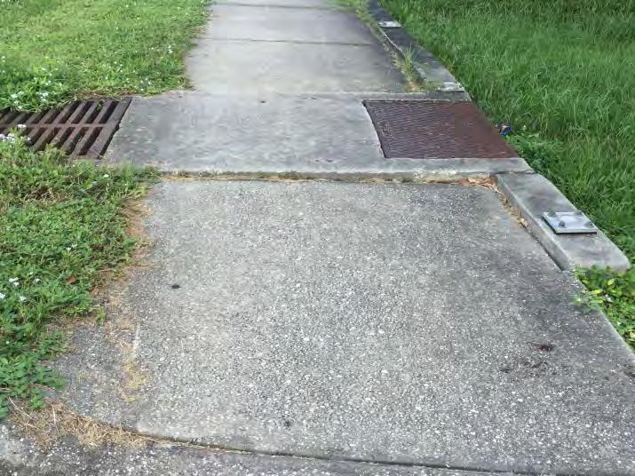
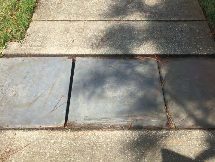
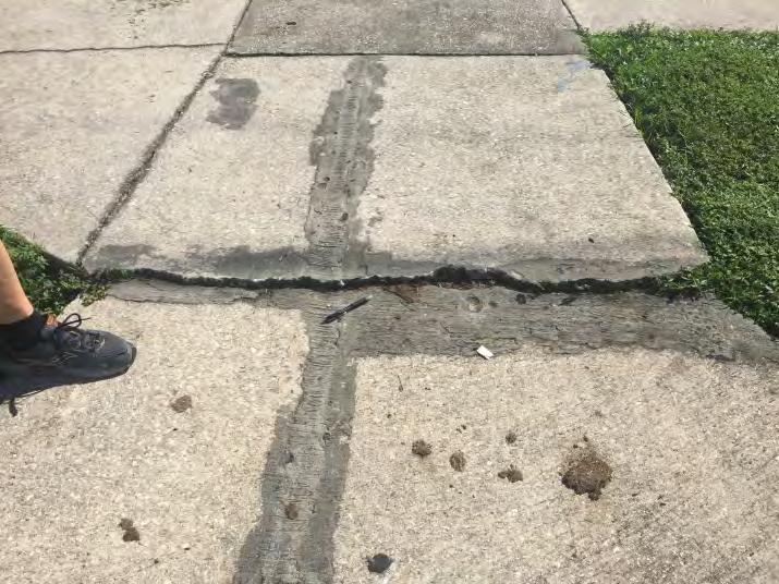
38 Description of Issue: The intent of the RSA is to consider safety for all user groups based on both crash data and risk factors. There may not be crash data supporting the noted design deficiencies, but the RSA team conducted a risk based assessment and identified the locations to address potential safety issues based on risk. The RSA team noted several ADA issues that are summarized below. These may not represent a complete list, but identify typical issues along the corridor. With the exception of Sarno Road, no detectable warning surfaces were present at any signalized intersection curb ramps, as illustrated in Figure 58. An existing railing support (shown in Figure 59) is missing on the east side of Wickham Road, in front of Chili s. If the rail was relied upon by a pedestrian, it may not support the weight of the pedestrian and not provide the protection it was intended to provide when it was installed. The effective width of sidewalk in front of Sabal Elementary School is reduced to less than four feet due to a drainage issue that has resulted in regular ponding, as shown in Figure 60. The sidewalk is cracking and could present a barrier for a wheelchair pedestrian on the north side of Sarno Road, and east of the intersection with Wickham Road, as shown in Figure 6. The sidewalk was cut to accommodate a utility pole (shown in Figure 6) on the west side of Wickham Road, approximately 00 north of Sarno Road. The effective width is less than the minimum of 4. ADA PROWAG section R30.3 specifies the continuous clear width of pedestrian access routes shall be 4 minimum, exclusive of the width of the curb. In the northwest corner of the primary driveway to Melbourne Village Plaza (460 south of Eau Gallie Boulevard), the downward slope of the curb ramp begins at the back of the sidewalk leaving no turning space at the top of the ramp (shown in Figure 63). According to section R304.. of the ADA PROWAG, a turning space of 4 minimum by 4 minimum shall be provided at the top of the curb ramp. As illustrated in Figure 64 to Figure 67, the RSA team observed several locations along the corridor where the sidewalk was not flush, creating trip hazards. In some cases, drainage inlet structures were either slightly raised above or depressed below the sidewalk surface. Table 4. Qualitative Risk Rating for Observed ADA Issues Function Classification Reasoning Exposure Category I Impacts pedestrians and individuals with disabilities Probability Category I Issues may not directly contribute to injury, but does limit connectivity and access Consequence Category I ADA issues may not lead to crashes between nonmotorists and vehicles Overall Category I 36
39 Suggestions for Improvement: The RSA team suggests conducting a formal ADA evaluation along the corridor, but highlights the following typical improvements for consideration to address the ADA issues described above: Maintenance type improvements: o Consider replacing/installing detectable warning surfaces per FDOT Design Standard Index 304 at all signalized intersections, except Sarno Road. o Consider replacing railing support on the east side of Wickham Road, in front of Chili s. o Consider reconstructing the sidewalk on the north side of Sarno Road east of the intersection with Wickham Road to repair section with cracked concrete. o Consider widening sidewalk around the utility pole on the west side of Wickham Road, approximately 00 north of Sarno Road. o Consider grinding the sidewalk to provide flush surfaces throughout the study corridor. Near term improvements: o Evaluate drainage issue that restricts effective sidewalk width in front of Sabal Elementary School. o Consider rebuilding the curb ramps in the northwest corner of the primary driveway to Melbourne Village Plaza (460 south of Eau Gallie Boulevard) to provide a 4 x4 turning space needed at the top of the curb ramp. 37


40 Issue #5: Lack of Sidewalks along Wickham Road Location: Corridor Wide Figure 68 Pedestrian Path on West Side near Orange Manor Drive Figure 69 Pedestrian Path on West Side in Front of Auto Zone Source: Google Maps 06 Figure 70 Discontinuous Sidewalk on the East Side near Aurora Road Intersection Figure 7 Figure 7 38
41 Description of Issue: The intent of the RSA is to consider safety for all user groups based on both crash data and risk factors. There may not be crash data supporting the noted design deficiencies, but the RSA team conducted a risk based assessment and identified the locations to address potential safety issues based on risk. No sidewalk is provided on the west side of the roadway from north of Sabal Elementary School to Parkway Drive. Pedestrian usage of the shoulder on the west side of Wickham Road is evidenced by the pedestrian foot path (shown in Figure 68 and Figure 69). Sidewalk on the east side of Wickham Road is discontinuous on the south leg of the Aurora Road intersection, as shown in the aerial in Figure 70. The sidewalk terminates into a parking lot and pedestrians must travel through the parking lot to continue along the east side of Wickham Road. Examples of the termination of the sidewalk are displayed in Figure 7 and Figure 7. Table 5. Qualitative Risk Rating for Lack of Sidewalk along Wickham Road Function Classification Reasoning Exposure Category II Pedestrians need to use discontinuous sidewalk on the east side Probability Category I No pedestrian/bicycle crashes reported due to this issue Consequence Category III Potential for pedestrian/bicycle crash types Overall Category II Suggestions for Improvement: In the near term, consider a feasibility study for installation of sidewalks on the west side of Wickham Road. Utility poles, drainage, and minimal right of way are major factors to consider. As part of this study, assess the feasibility of filling gaps in sidewalk on east side of Wickham Road. 39


42 Issue #6: Street Name Signage Visibility Location: Corridor Wide Figure 73 Figure 74 Description of Issue: Street name signage (D3 ) is difficult to see at night due to size, inconsistent location, and limited retroreflectivity, as illustrated in Figure 73 and Figure 74. This issue applies at the study signalized intersections and unsignalized minor street approaches. Increasing the distance from which a driver can see the street signs may reduce potential for rear end crashes associated with sudden deceleration from turning vehicles. Table 6. Qualitative Risk Rating for Street Name Sign Visibility Function Classification Reasoning Exposure Category I Not usually an issue for local drivers Probability Category I No crashes reported due to this issue Consequence Category I Potential for rear ends typically result in PDO or minor injury Overall Category I Suggestions for Improvement: In the near term, consider replacing street name signage (D3 ) with new retro reflective signs using applicable font size following the guidance provided in section D 43 of the 009 Manual on Uniform Traffic Control Devices (MUTCD). Table I specifies 6 letter height on post mounted street signs at intersections along roadways with a posted speed of 40 mph or less. Consider interior illuminated, overhead LED street name signs at the signalized locations, per Table A of the MUTCD. 40


43 Location: Sarno Road Intersection Issue #7: Left Turn Crashes Source: Google Earth 06 Figure 75 Figure 76 Figure 77 Description of Issue: Over the crash analysis period, there were 6 left turn crashes with the following distributions on each leg: involved northbound left turning vehicles 6 involved southbound left turning vehicles 6 involved westbound left turning vehicles involved eastbound left turning vehicles 4
44 Figure 75 shows an aerial of the lane configurations at the intersection. A protected/permissive mode with a doghouse five section signal display is currently in use and the number of left turn crashes caused by left turn drivers at the intersection has exceeded six per year in 009 and 03. This situation allows for consideration of protected left turn phasing per the Florida Traffic Engineering Manual (Section 3..). Figure 76 illustrates the permissive left turn phase along the southbound approach of Wickham Road. Long queues were observed along the northbound approach in the peak hours as shown in Figure 77. The operations of the intersection may be encouraging drivers to accept smaller gaps during the permissive left turn phases as suggested by the crash history at the intersection. Table 7. Qualitative Risk Rating for Left Turn Crashes Function Classification Reasoning Exposure Category II Moderate volume of left turns Probability Category II Represents 5 percent of reported injury crashes at intersection Consequence Category III 43 percent of left turn crashes resulted in injury Overall Category II Suggestions for Improvement: In the near term, consider converting from protected/permissive to protected only left turn phasing to reduce left turn crash potential. By removing the permissive phase, the conflict between left turning vehicles and opposing through movements is eliminated and could reduce the frequency of left turn crashes. However, removing the permissive phase may have a negative impact on the overall operations at the intersection. In addition, the agency may consider converting the existing protected/permissive doghouse fivesection signal displays to a protected/permissive flashing yellow arrow signal displays. With this display, the agency may operate protected left turn phases during specific time periods, but still allow permissive left turns during off peak periods. A feasibility study could be conducted to evaluate the operational impacts of the left turn signal phasing conversion. Adjustments to the cycle length, splits, etc. could also be evaluated. 4

.")

45 Location: Sarno Road Intersection Issue #8: Walmart Gas Station Driveway on Sarno Road Source: Google Maps 06 Figure 78 Location of Walmart Fuel Station Driveway on Sarno Road Figure 79 Vehicle Waiting from Walmart Fuel Station Driveway to East Figure 80 Vehicle Exiting from Walmart Fuel Station Driveway to East Description of Issue: A full access driveway on the north side of Sarno Road, approximately 60 feet west of Wickham Road, serves PNC Bank, a fuel station, and Walmart (see Figure 78). During peak periods, the eastbound leftturn and through queues from the Wickham Road/Sarno Road intersection extend past the driveway. Drivers were observed making southbound left turn movements from the driveway and queued in the westbound Sarno Road travel lanes effectively blocking traffic along Sarno Road until they can find a gap in the eastbound queue (see Figure 79 and Figure 80). 43
46 Table 8. Qualitative Risk Rating for Walmart Gas Station Driveway on Sarno Road Function Classification Reasoning Exposure Category II During periods when westbound left turn queues extend beyond driveway Probability Category I No reported crashes Consequence Category III Potential for angle crash type Overall Category II Suggestions for Improvement: In the near term, consider restricting the driveway to right in/right out only by constructing concrete median to enforce the restriction. This would require more traffic to use the main Walmart entrance/exit driveway approximately 700 feet west of the Wickham Road/Sarno Road intersection. 44


47 Location: Sarno Road Intersection Issue #9: Pedestrian Signal Head and Push Button Signage Figure 8 Figure 8 Description of Issue: The pedestrian signal head on the northeast corner is crooked as shown in Figure 8. The pedestrian signal head has been struck and is cracked. The push button signage on the same pole has been scratched off as illustrated in Figure 8. Table 9. Qualitative Risk Rating for Pedestrian Signal Head and Push Button Signage Function Classification Reasoning Exposure Category I Impacts pedestrians only Probability Category I Few users will notice this issue Consequence Category I ADA issues may not lead to crashes between nonmotorists and vehicles Overall Category I Suggestions for Improvement: As a maintenance improvement, consider replacing the pedestrian signal head and push button signage. 45
.")

48 Location: Mid Block between Sarno Road to Melbourne Greyhound Park Issue #0: Walmart Driveway on Wickham Road Figure 84 Source: Google Maps 06 Figure 83 Description of Issue: A full access driveway on the west side of Wickham Road, approximately 500 feet north of Sarno Road, serves Walmart and several other retailers (shown in Figure 83). The eastbound left turn movement onto Wickham Road conflicts with the northbound left turn into the driveway. Given that northbound left turns have right of way, the delay to exiting traffic at the driveway is heavily influenced by the northbound left turn demand. Drivers were observed taking short gaps in traffic after having been delayed at this driveway. Some drivers were observed using the center TWLTL as a refuge before pulling into the northbound lanes, while some drivers were observed waiting for a simultaneous gap in both northbound and southbound traffic. Figure 84 shows the eastbound approach at the driveway. Table 0. Qualitative Risk Rating for Walmart Driveway on Wickham Road Function Classification Reasoning Exposure Category II During peak periods only Probability Category I No reported crashes Consequence Category III Potential for angle crash type Overall Category II 46
49 Suggestions for Improvement: In the near term, consider restricting the driveway to left in/right in/right out only by constructing a concrete directional median to restrict the eastbound left turn at the driveway. This would require more traffic to use the Greyhound Park signal to go north on Wickham Road. 47
. Maintenance crews are suggested to remove this sign and its posts to reduce driver distraction.")
50 Issue #: Maintenance to Remove Sign Location: Melbourne Greyhound Park Source: Google Earth Figure 85 Description of Issue and Suggestion: An old sign indicates END ROAD WORK, but no construction work is currently underway in the area (shown in Figure 85). Maintenance crews are suggested to remove this sign and its posts to reduce driver distraction. 48

51 Location: Eau Gallie Boulevard Intersection Issue #: Eastbound Right Turn Curb Return Radius Source: Google Earth 06 Wickham Road Figure 86 Description of Issue: A WB 6 truck could not make the eastbound right turn without driving over the median on the northbound approach. Figure 86 shows the existing intersection configuration. A truck making this wide turn could encroach into the northbound left turn lane, or the truck may block the lane while waiting for the northbound left turn to clear to provide adequate width for the turn. Table. Qualitative Risk Rating for Eastbound Right Turn Curb Return Radius Function Classification Reasoning Exposure Category I Applied only to large trucks Probability Category I No reported crashes Consequence Category II Potential for low speed crashes Overall Category I Suggestions for Improvement: In the near term, consider reconstructing the curb radius to accommodate a larger radius turn so that large trucks can turn without encroaching into the northbound left turn lane. This could result in a longer crossing distance for pedestrians. Another option is to consider adjusting the median nose on the northbound concrete median. Both considerations will need to perform a swept path design vehicle check to evaluate designs that accommodate the movement. 49

52 Location: Eau Gallie Boulevard Intersection Issue #3: Right Turn Phase Conflict with Pedestrian Crossing Figure 87 Observed Pedestrian Crossing on East Approach of Eau Gallie Boulevard/Wickham Road Intersection Figure 88 Observed Right Turn Vehicle on South Approach of Eau Gallie Boulevard/Wickham Road Intersection Description of Issue: Through/right turn traffic phase runs concurrent with the pedestrian phase on the perpendicular approach. The crossing guards from Sabal Elementary School indicated that right turn traffic does not yield to pedestrians/bicyclists in the crosswalk. Drivers were observed making right turns while pedestrians/bicyclists were in the adjacent lane of the exiting leg crosswalk. Also, some drivers made right turns on red while pedestrians/bicyclists were in the crosswalk. Figure 87 and Figure 88 show examples of the pedestrian and vehicle activity at the intersection. Table. Qualitative Risk Rating for Right Turn Phase Conflict with Pedestrian Crossing Function Classification Reasoning Exposure Category III Observed high pedestrian/bicyclist volumes in proximity to school Probability Category III Three crashes reported involving bicyclists and right turn vehicles Consequence Category III Pedestrian/bicycle crash types Overall Category III 50

.")
53 Suggestions for Improvement: In the near term, the following are considerations for reducing conflicts between pedestrians/bicyclists and right turning vehicles within the intersection influence area: Implement leading pedestrian phase intervals, delaying the through green phase until after pedestrians have had a chance to begin crossing. Install signage that reminds turning traffic to yield to pedestrians (see R0 5 from the 009 MUTCD shown in Figure 89). Restrict right turns on red during school hours with a dynamic message sign (see example in Figure 90). Figure 89: R0 5 Signage from the MUTCD Figure 90 Example of Dynamic Right Turn Restriction Signage on Wickham Road 5
.")
54 Issue #4: School Zone Extents Location: Mid Block between Eau Gallie Boulevard to Aurora Road Source: Google Maps 06 Figure 9 Aerial of School Zone for Sabal Elementary School Figure 9 END SCHOOL ZONE Sign for Southbound Wickham Road Description of Issue: A School Zone is designated on Wickham Road in front of Sabal Elementary School (see Figure 9). The school zone for southbound traffic ends approximately 50 feet north of Eau Gallie Boulevard (shown in Figure 9). Drivers were observed accelerating after leaving the school zone up to the signal at Eau Gallie Boulevard to get through during the green phase. This behavior may contribute to rear end crashes on the southbound approach at the signalized intersection where students cross Wickham Road. Table 3. Qualitative Risk Rating for School Zone Extents Function Classification Reasoning Exposure Category I During school hours only Probability Category I Conflicts exist when accelerating vehicle arrives during yellow or all red phase Consequence Category II Potential for rear end crash types Overall Category I 5
55 Suggestions for Improvement: In the near term, consider extending the school zone to the Eau Gallie Boulevard intersection. This would reduce incentive for drivers to accelerate out of the school zone when the signal is only 50 feet downstream. 53
.")

56 Location: Mid Block between Eau Gallie Boulevard to Aurora Road Issue #5: Unsignalized Crosswalk at Trimble Road Source: Google Earth 06 Figure 93 Figure 94 Description of Issue: An uncontrolled pedestrian crossing at the Wickham Road/Trimble Road intersection is located approximately 475 feet north of Sabal Elementary School (shown in Figure 93). The crossing is marked with the old standard emphasis markings (Figure 94). Wickham Road has a 5 lane cross section with no raised median at the crossing location and carries greater than,000 vehicles per day. Per the 03 Traffic Control Device Handbook, Marked crosswalks alone (without other substantial treatments) should not be installed across uncontrolled roadways in these conditions. Table 4. Qualitative Risk Rating for Unsignalized Crosswalk at Trimble Road Function Classification Reasoning Exposure Category III Crossing serves school and other pedestrians Probability Category II Multilane crossing and posted speed of 35 mph Consequence Category III Potential for pedestrian/bicycle crash types Overall Category III This guidance is provided in Chapter 3 of the TCD Handbook, but the exact wording in the 009 MUTCD on this issue is currently worded slightly differently and is being considered for revision by FHWA. 54
57 Suggestions for Improvement: In the near term, consider low cost enhancements to increase visibility of the pedestrian crossing, including: Special emphasis markings as shown on sheet 0 of the FDOT Design Standard Index 7346 should be used for the crossing. Construct raised median or crossing island on the north side of the intersection. If median is desired, the crossing should be moved to the north side of Trimble Road to avoid conflicts with the northbound left turn. See the conceptual sketch in Figure 95. Enhance striping to include advance stop lines and solid striping between travel lanes to reduce lane changes. o Advance stop or yield lines encourage drivers to stop further back from the crosswalk, promoting better visibility between pedestrians and motorists, and helping to prevent multiple threat crashes at uncontrolled crossings. o A multiple threat collision is a pedestrian crash that occurs when pedestrians have to cross more than one lane in each direction. A motor vehicle in one lane stops and provides a visual screen to the motorist in the adjacent lane. The motorist in the adjacent lane continues to move and hits the pedestrian. o The 009 MUTCD recommends that yield or stop lines used at uncontrolled multi lane crossings be placed 0 to 50 feet in advance of the crosswalk; however, according to PEDSAFE 03, a setback of 30 feet for the advance stop or yield lines (in advance of the crosswalk) has been found to be appropriate for most situations. Install Pedestrian Activated Rectangular Rapid Flashing Beacons (RRFBs) o RRFBs are active warning devices used to alert motorists of crossing pedestrians at uncontrolled crossings. They remain dark until activated by pedestrians, at which point they emit a bright, rapidly flashing yellow LED light. o Studies suggest that RRFBs can significantly increase yielding rates compared to standard pedestrian warning signs alone. Results have shown that motorist yielding can be increased from baselines averaging 5 percent to 0 percent with the standard pedestrian warning sign treatment only to sustainable yielding rates of 80 percent or higher with this device. o RRFBs should be considered on both the right and left sides of both the southbound and northbound approaches. They are not currently included in the MUTCD, FDOT has obtained approval from FHWA, under the terms and conditions of Interim Approval II (see section IA.0 of the MUTCD). 55

58 Figure 95 Conceptual Sketch of Relocated Crossing with Pedestrian Refuge Island 56

59 Issue #6: Incomplete Pedestrian Facilities Location: Aurora Road Intersection Aurora Road Wickham Road Source: Google Earth 06 Figure 96 Description of Issue: As discussed in Issue #5: Lack of Sidewalks along Wickham Road, the sidewalk on the east side of Wickham Road terminates 45 feet south of the intersection, as shown in Figure 96, creating a gap in pedestrian routes. At the intersection, no marked crossings are provided to the southeast corner and no pedestrian signal equipment exists for these movements. Pedestrians with a destination in the southeast corner of the intersection must use judgment to identify an appropriate time to cross. A marked crosswalk is provided on the west leg, but no sidewalks are provided along the west side of Wickham Road or along either side of Aurora Road. The lack of sidewalks requires pedestrians to walk on the shoulder or may serve as a barrier for walking as a mode of travel. Wires for the push button on the northeast corner are exposed. 57
60 Table 5. Qualitative Risk Rating for Incomplete Pedestrian Facilities Function Classification Reasoning Exposure Category I Low pedestrian volumes observed Probability Category III Pedestrians must judge gaps in traffic flow, introducing potential for human error Consequence Category III Potential for pedestrian/bicycle crash types Overall Category II Suggestions for Improvement: In the near term, the following considerations could help reduce risk to pedestrians at this intersection: Complete the segment of missing sidewalk on the east side of Wickham Road to the southeast corner of the intersection. Construct sidewalk on at least one side of Aurora Road. Provide marked crossings on the east and south legs of the intersection and install necessary pedestrian signal equipment. Cover up the exposed wires associated with the push button in the northeast corner. 58
.")

61 Location: Aurora Road Intersection Issue #7: Westbound Through Movement Alignment Aurora Road Source: Google Earth 06 Source: Google Earth Figure 97 Figure 98 Description of Issue: The westbound through lane aligns vehicles toward the northwest corner of the intersection, as shown in the street view image (Figure 97). The visibility of the roadway on the far side of the westbound approach is reduced at night. Table 6. Qualitative Risk Rating for Westbound Through Movement Alignment Function Classification Reasoning Exposure Category I Applies to westbound through movements only Probability Category I Local drivers expect alignment Consequence Category II Potential for ingle vehicle run off road crashes Overall Category I Suggestions for Improvement: As a maintenance type improvement, consider dotted guide line striping between the westbound leftturn lane and westbound through/right lane (east leg) to tie in between the eastbound left turn lane and westbound receiving lane (west leg) along the Aurora Road approach. Consider using to 4 dotted guide line striping consistent with sheet of the FDOT Design Standard Index An example of the striping location is illustrated in Figure
. There were 54 reported crashes between Aurora Road and Lake Washington Road.")
62 Issue #8: Lighting Location: Mid Block between Aurora Road and Lake Washington Road Figure 99 Description of Issue: The majority of the corridor has illumination, except between Aurora Road and Lake Washington Road where several lights were out of service (see Figure 99). There were 54 reported crashes between Aurora Road and Lake Washington Road. The crash history indicated that 0 percent of the crashes along the corridor occurred under dark lighting conditions (dawn, dusk, dark lighted, and darkunlighted). Table 7. Qualitative Risk Rating for Lighting Function Classification Reasoning Exposure Category I Limited to dark hours Probability Category II Lack of illumination may create motor vehicle conflicts Consequence Category II Potential for various crash types/severities Overall Category II 60
63 Suggestions for Improvement: As a maintenance type improvement, consider contacting the operator/maintainer to replace the luminaires at the following locations: Repair/replace applicable street lights between Aurora Road and Lake Washington Road 6


64 Location: Northgate Plaza Intersection Issue #9: No Pedestrian Crossings at Northgate Plaza Signal Northgate Plaza Northgate Street McDonald s Source: Google Earth 06 Figure 00 Figure 0 Description of Issue: The existing signal to the Northgate Plaza does not provide pedestrian crossings to the sidewalk on the east side of Wickham Road as shown in Figure 00. Without a signalized crossing within the vicinity of the many commercial land uses, pedestrians are likely to cross at mid block locations where drivers are not expecting pedestrians. The RSA team identified that volumes have redistributed since the signal was installed and the highest turn movement volumes are at the north driveway to the Plaza or at Northgate Street (illustrated in Figure 0). These locations serve McDonald s, Goodwill, Krispy Kreme, and Fun Town. Relocating the signal to the Northgate Street intersection would provide a pedestrian crossing near the highest trip generating uses. Table 8. Qualitative Risk Rating for No Pedestrian Crossings at Northgate Plaza Signal Function Classification Reasoning Exposure Category I Low pedestrian volumes observed Probability Category I Pedestrians must judge gaps in traffic flow, introducing potential for error Consequence Category III Potential for pedestrian/bicycle crash types Overall Category II 6
65 Suggestions for Improvement: In addition to markings that support pedestrian crossings at signals along the corridor, consider the following near term improvements to provide pedestrian facilities at this intersection: Upgrade the existing signal to include a signalized crossing of Wickham Road, including pedestrian signals, accessible push buttons, and special emphasis crosswalk markings. Consider constructing sidewalks on the west side of Wickham Road and upgrade the existing signal to include a signalized crossing of the Northgate Plaza approach, including pedestrian signals, accessible push buttons, and standard special emphasis crosswalk markings. Consider completing a signal warrant analysis at the current Northgate Plaza signalized intersection and at the Northgate Street intersection. 63


66 Issue #0: Driveway Turn Movement Conflicts Location: Lake Washington Road Intersection Source: Google Earth 06 Figure 0 Figure 03 Description of Issue: A driveway that serves the Lake Washington Plaza is located within 5 feet of the Lake Washington Road signal (shown in Figure 0). Outbound left turns from the driveway conflict with northbound approach queues. Over the crash analysis period, 3 angle crashes were identified at the driveway 64
67 location denoted in Figure 0. Twenty eight (8) angle crashes occurred at the Lake Washington Road intersection with 3 crashes occurring at a driveway within the influence area of the signal. The RSA team observed queues frequently extending beyond the northernmost driveway to the Lake Washington Square in the southeast corner of the intersection as illustrated in Figure 03. Drivers are attempting to make a left turn from the driveway to travel south along Wickham Road. Drivers exiting the driveway were observed traveling between queued northbound vehicles to access the southbound lanes. Table 9. Qualitative Risk Rating for Driveway Turn Movement Conflicts Function Classification Reasoning Exposure Category I One of three driveways to the Plaza Probability Category I Conflicts exist during peak periods Consequence Category III Potential for angle or turning crashes which may lead to injury Overall Category II Suggestions for Improvement: In the near term, consider restricting the northernmost driveway on the southeast corner of the intersection to right in/right out only by installing a pork chop island. 65
.")
68 Issue #: Westbound Lane Drop Location: Lake Washington Road Intersection Source: Google Earth 06 Figure 04 Description of Issue: The outside through lane becomes the westbound right turn lane at the intersection. There are two right turn arrows and a Right Turn Lane Must Turn Right sign approximately 00 feet east of the intersection (shown in Figure 04). This relatively short advanced warning distance could create lane shifts near the intersection. Table 0. Qualitative Risk Rating for Westbound Lane Drop Function Classification Reasoning Exposure Category I Local drivers expect the lane drop Probability Category I Failure to anticipate lane drop leads to a merge maneuver Consequence Category I Potential for sideswipe crash types Overall Category I Suggestions for Improvement: As a maintenance type improvement, consider installing advance warning signage, striping additional right turn arrows, and including ONLY pavement markings in addition to the arrows to warn drivers of the lane drop as they approach the intersection (see sheet 6 of the FDOT Design Standard Index 7346 and the MUTCD Section 3B.0). 66
 and no pedestrian signal equipment exists for these movements.")

69 Issue #: Incomplete Pedestrian Facilities Location: Lake Washington Road Intersection Source: Google Maps 06 Figure 05 Figure 06 Description of Issue: No marked crossings are provided to the southwest corner (see Figure 05) and no pedestrian signal equipment exists for these movements. Pedestrians with a destination in the southwest corner of the intersection must use judgment to identify an appropriate time to cross (as shown in Figure 06). Similar to other locations along the corridor, no sidewalks are present on the west side of Wickham Road in the vicinity of Lake Washington Road. The lack of sidewalks requires pedestrians to walk on the shoulder or may serve as a barrier for walking as a mode of travel. Table. Qualitative Risk Rating for Incomplete Pedestrian Facilities Function Classification Reasoning Exposure Category I Low pedestrian volumes observed Probability Category III Pedestrians must judge gaps in traffic flow, introducing potential for human error Consequence Category III Potential for pedestrian/bicycle crash types Overall Category II Suggestions for Improvement: To reduce potential for pedestrian crashes on the south and west approaches, consider the following near term improvements: Provide marked crossings on the west and south legs of the intersection and install necessary pedestrian signal equipment. Construct a sidewalk on the west side of Wickham Road in the vicinity of the intersection. 67


70 Issue #3: Pedestrian Crossing Alignment Location: Lake Washington Road Intersection Source: Google Earth 06 Figure 07 Figure 08 Description of Issue: The crosswalk on the north leg is aligned into the westbound right turn lane. Examples of this are shown in Figure 07 and Figure 08. The existing crossing markings do not guide pedestrians to the accessible ramp in the northeast corner. Table. Qualitative Risk Rating for Pedestrian Crossing Alignment Function Classification Reasoning Exposure Category I Number of impaired pedestrians is low relative to number of other users Probability Category II Applies to crossings from the NW corner to NE corner only Consequence Category III Potential for pedestrian/bicycle crash types Overall Category II Suggestions for Improvement: In order to reduce risk of pedestrian crashes involving pedestrians crossing Wickham Road from the northwest to the northeast corner, consider realigning the crosswalk to align with the northeast corner curb ramp, and reconstruct the curb ramp to provide a pedestrian warning surface as a near term improvement. 68


71 Location: Mid Block between Lake Washington Road and Parkway Drive Issue #4: Exposed Drainage Inlet Adjacent to Sidewalk Figure 09 Figure 0 Description of Issue: A drainage inlet is located between the eastern sidewalk and the northbound travel lanes to the north of Harbor Sun Green Road. There is a steep slope to the bottom of the drainage inlet structure and the edges of the structure are flush with the sidewalk (examples shown in Figure 09 and Figure 0). This creates a potential hazard for pedestrians or bicyclists. Table 3. Qualitative Risk Rating for Exposed Drainage Inlet Adjacent to Sidewalk Function Classification Reasoning Exposure Category I Impacts pedestrians or bicyclists on sidewalk Probability Category II Does not impact pedestrians unless they need additional path width beyond current width. Consequence Category III Potential for pedestrian/bicycle hazard Overall Category II Suggestions for Improvement: Due to the drop/steep slope between the sidewalk and drainage inlet, consider reviewing this location based on FDOT Plans Preparation Manual (PPM) Figure 8.8. to possibly install a railing in the near term. If railing is needed, install the railing just off the west edge of the sidewalk to prevent pedestrians/bicyclists from falling off the sidewalk into the drainage ditch area. 69
 and no pedestrian signal equipment exists for these movements.")
72 Issue #5: Incomplete Pedestrian Facilities Location: Parkway Drive Intersection Source: Google Earth 06 Figure Aerial Photo Showing Existing Crosswalks at the Parkway Drive/Wickham Road Intersection Description of Issue: No marked crossings are provided to the northwest corner (see Figure ) and no pedestrian signal equipment exists for these movements. Pedestrians with a destination in the northwest corner of the intersection must use judgment to identify an appropriate time to cross the north or west approaches. Sidewalks are present to the north side of the 7 driveway as shown in Figure ; however, sidewalks are not present from the driveway to the northwest corner of the intersection. Open drainage exists adjacent to the southbound lanes on the north side of Parkway Drive. 70
73 Table 4. Qualitative Risk Rating of Incomplete Pedestrian Crossing Facilities Function Classification Reasoning Exposure Category I Low pedestrian volumes observed Probability Category III Pedestrians must judge gaps in traffic flow, introducing potential for human error Consequence Category III Potential for pedestrian/bicycle crash types Overall Category II Suggestions for Improvement: To reduce potential for pedestrian crashes on the north and west approaches, consider the following near term improvements: Provide marked crossings on the north and west legs of the intersection and install necessary pedestrian signal equipment. Complete the segment of missing sidewalk on the west side of Wickham Road between the north side of the 7 driveway to the northwest corner of the intersection. Construct pedestrian ramps in the northwest corner of the intersection to connect to the gas station/convenience store in this quadrant of the intersection. 7
74 Summary of Suggestions This RSA considers operational and safety related issues for vehicles, pedestrians, and bicyclists on Wickham Road from Sarno Road to Parkway Drive. This study was commissioned by the SCTPO to develop suggestions to improve the safety of motorists and non motorists within the study limits. Each suggestion identified in this study is classified into one of three categories: Maintenance issues identified for maintenance may be addressed by public agency staff on a short timeframe and at a relatively low cost. Near Term Improvement (within 5 years) activities that may be incorporated into an upcoming construction project in the area, including 3R milling and resurfacing projects. Long Term Improvement (5+ years) activities that may be incorporated into upcoming construction projects and may need to be programmed for funding as separate projects. Tables containing the transit related improvements are provided on the next pages. The tables following the transit tables summarize the corridor suggestions by priority (maintenance, near term, or long term) of this study. 7
75 Location Issue Number Issue Suggestion TRANSIT RELATED Remove the pavement at the existing boarding and alighting (B&A) area; Pave a level 5 x8 slab with a raised 6" curb to create a raised and level B&A area; Brunswick Harbor Lanes N/A Bus Stop Add detectable warnings to the nearby curb ramps; Northbound Move the bench so it is not blocking the path to the sidewalk; and Move the pole with the bus schedule adjacent to the pavement to make it accessible. Melbourne Village Northbound Eau Gallie Boulevard Westbound N/A N/A Bus Stop Bus Stop Aldi's Southbound N/A Bus Stop Pine Hill Drive Northbound Orange Manor Drive Southbound N/A N/A Bus Stop Bus Stop Aurora Road Northbound N/A Bus Stop Aurora Road/CVS Southbound Lake Washington Road Southbound N/A N/A Bus Stop Bus Stop Move the stop 450' north; Pave a level 5 x8 slab with a raised 6 curb for the B&A area and connect to the adjacent sidewalk; Add detectable warnings to the nearby curb ramps; and Move the pole with the bus schedule adjacent to the pavement to make it accessible. Pave a level 5 x3 slab between the curb and sidewalk to complete a 5 x8 B&A area; and Add detectable warnings to the nearby curb ramps. Pave a level 5 x slab behind the sidewalk to complete a 5 x8 B&A area; and Extend the detectable warning at the nearby curb ramps. Move the stop 75' south; Pave a level 5 x3 slab between the curb and sidewalk to complete a 5 x8 B&A area; Add detectable warnings to the nearby curb ramps. Move the stop 45' north; Pave a level 5 x3 slab between the curb and sidewalk to complete a 5 x8 B&A area; Repave the cracks in the sidewalk; and Repave the existing curb ramp and add detectable warnings. Move the stop 380' north; Pave a level 5 x8 slab for the B&A area; Add a 0' path from the B&A area to the sidewalk; and Add detectable warnings to the nearby curb ramps. Pave a level 5 x6 slab between the curb and sidewalk to complete a 5 x8 B&A area; Add detectable warnings to the nearby curb ramps; and Move the pole with the bus schedule adjacent to the pavement to make it accessible. Pave a level 5 x8 slab for the B&A area; Move the pole with the bus schedule adjacent to the pavement to make it accessible; Add a 00' path to connect the north; Construct a curb ramp with a slope less than 8.3%; Add detectable warnings to the nearby curb ramps; and Add a crosswalk at the intersection. 73
76 Location Issue Number Issue Suggestion TRANSIT RELATED Checkers Northbound N/A Bus Stop Move the stop 30' south; Resurface the B&A area to have a cross slope of less than %; Pave a level 5 x8 slab for the B&A area; Add a 7' path to connect the B&A area to the existing sidewalk; Add detectable warnings to the nearby curb ramps; and Resurface the sidewalk to remove the change in elevation. Move the stop 5' south; Resurface the B&A area to have a cross slope of less than %; Portofino Villas Pave a level 5 x8 slab for the B&A area; N/A Bus Stop Southbound Pave a 5' sidewalk to connect to the intersection to the south; Construct a curb ramp with a slope less than 8.3%; and Add detectable warnings to the curb ramps. Harbor Sun Green Road Northbound Preakness Place/Lake Point Apartments Southbound Weston Drive Northbound N/A N/A N/A Bus Stop Bus Stop Bus Stop CVS Southbound N/A Bus Stop Parkway Drive Northbound N/A Bus Stop Move the stop 0' south; Add a culvert and pave a level 5'x8' slab for the B&A area; Add a 4' path to connect the B&A area to the existing sidewalk; and Add detectable warnings to the nearby curb ramps. Add a culvert to the drainage area; Pave a level 5'x8' slab with a raised 6" curb for the B&A area; Pave a path from the B&A area to the nearby driveway; Add a curb ramp and detectable warning; and Move the pole with the bus schedule adjacent to the pavement to make it accessible. Pave a level 5 x4 slab between the curb and sidewalk to complete a 5 x8 B&A area; Add detectable warnings to the nearby curb ramps; and Move the pole with the bus schedule adjacent to the pavement to make it accessible. Move the stop 5' north; Pave a level 5 x8 slab for the B&A area; Add a 3' path to connect the B&A area to the existing sidewalk; Add detectable warnings to the nearby curb ramps; and Move the pole with the bus schedule adjacent to the pavement to make it accessible. Pave a level 5 x8 slab for the B&A area; Add a 5' path to connect the B&A area to the existing sidewalk; and Add detectable warnings to the nearby curb ramps. 74
77 Location Issue Number Issue Suggestion MAINTENANCE Corridor Wide 4 Observed ADA Issues The RSA team suggests conducting a formal ADA evaluation along the corridor, but highlights the following typical maintenancetype improvements for consideration to address the ADA issues: o Consider replacing/installing detectable warning surfaces per FDOT standard index 304 at all signalized intersections, except Sarno Road. o Consider replacing railing support on the east side of Wickham Road, in front of Chili s. o Consider reconstructing the sidewalk on the north side of Sarno Road east of the intersection with Wickham Road to repair section with cracked concrete. o Consider widening sidewalk around the utility pole on the west side of Wickham Road, approximately 00 north of Sarno Road. o Consider grinding the sidewalk to provide flush surfaces throughout the study corridor. Sarno Road Intersection 9 Pedestrian Signal Head Consider replacing the pedestrian signal head and push button signage. and Push Button Signage Melbourne Greyhound Park Intersection Aurora Road Intersection 7 Mid Block between Aurora Road and Lake Washington Road Lake Washington Road Intersection Maintenance to Remove Sign Westbound Through Movement Alignment 8 Lighting Westbound Lane Drop Maintenance crews are suggested to remove this sign and its posts to reduce driver distraction. Consider dotted guide line striping between the westbound left turn lane and westbound through/right lane (east leg) to tie in between the eastbound left turn lane and westbound receiving lane (west leg) along the Aurora Road approach. Consider using to 4 dotted guide line striping consistent with sheet of the FDOT Design Standard Index An example of the striping location is illustrated in Figure 98. Consider contacting the operator/maintainer to repair/replace the light bulbs at applicable street lights between Aurora Road and Lake Washington Road. Consider installing advance warning signage, striping additional right turn arrows, and including ONLY pavement markings in addition to the arrows to warn drivers of the lane drop as they approach the intersection (see sheet 6 of the FDOT Design Standard Index 7346 and the MUTCD Section 3B.0). 75
78 Location Issue Number Issue Suggestion NEAR TERM PRIORITY Corridor Wide North/South Left Turn Movements at Signalized Intersections Consider replacing the doghouse five section signal displays with 4 section flashing yellow arrow (FYA) protected/permissive left turn display. If the left turn phasing is converted to a FYA display, consider providing protected only left turn phasing during peak periods and allow the protected permissive phasing during the off peak periods. Corridor Wide Corridor Wide 3 Lack of Right Turn Lanes at Signalized Intersections Intersection Crosswalk Markings Corridor Wide 4 Observed ADA Issues Corridor Wide 5 Corridor Wide 6 Lack of Sidewalks along Wickham Road Street Name Signage Visibility Consider evaluating right turn lane warrants for right turn lanes at the following intersections and approaches: Sarno Road (Southbound, Eastbound, Westbound) Greyhound Park (Southbound) Eau Gallie Boulevard (Southbound) Aurora Road (Northbound and Southbound) Lake Washington Road (Northbound and Southbound) Parkway Drive (Northbound and Southbound) Based on the analysis results, consider constructing right turn lanes where warrants are met. Priority should be given to approaches with the highest right turn volumes. Special emphasis crosswalk markings, as shown on sheet 9 of Design Index 7346, should be re striped at the following signalized crossings: Melbourne Greyhound Park (south, west, and east legs) Eau Gallie Boulevard (all legs) Aurora Road (north and west legs) Lake Washington Road (north and east legs) Parkway Drive (south and east legs) Consider marking all minor street approaches at unsignalized intersections along the corridor with standard crosswalk markings, as shown on sheet 9 of the FDOT Design Standard Index The RSA team suggests conducting a formal ADA evaluation along the corridor, but highlights the following typical improvements for near term consideration to address the ADA issues: o Evaluate drainage issue that restricts effective sidewalk width in front of Sabal Elementary School. o Consider rebuilding the curb ramps in the northwest corner of the primary driveway to Melbourne Village Plaza (460 south of Eau Gallie Boulevard) to provide a 4 x4 turning space needed at the top of the curb ramp. Consider a feasibility study for installation of sidewalks on the west side of Wickham Road. Utility poles, drainage, and minimal right of way are major factors to consider. As part of this study, assess the feasibility of filling gaps in sidewalk on east side of Wickham Road. Consider replacing street name signage (D3 ) with new retro reflective signs using applicable font size following the guidance provided in section D 43 of the 009 Manual on Uniform Traffic Control Devices (MUTCD). Table I specifies 6 letter height on post mounted street signs at intersections along roadways with a posted speed of 40 mph or less. Consider internally illuminated, overhead LED street name signs at the signalized locations, per Table A of the MUTCD. 76
79 Location Issue Number Issue Suggestion NEAR TERM PRIORITY Sarno Road Intersection 7 Left Turn Crashes Consider converting from protected/permissive to protected only left turn phasing to reduce left turn crash potential. Consider converting the existing protected/permissive doghouse five section signal displays to a protected/permissive flashing yellow arrow signal displays. With this display, the agency may operate protected left turn phases during specific time periods, but still allow permissive left turns during off peak periods. A feasibility study could be conducted to evaluate the operational impacts of the left turn signal phasing conversion. Adjustments to the cycle length, splits, etc. could also be evaluated. Sarno Road Intersection 8 Walmart Gas Station Consider restricting the driveway to right in/right out only by constructing concrete median to enforce the restriction. Driveway on Sarno Road Mid Block between Sarno Road and Melbourne Greyhound Park Eau Gallie Boulevard Intersection Eau Gallie Boulevard Intersection Mid Block between Eau Gallie Boulevard and Aurora Road 0 Walmart Driveway on Wickham Road Eastbound Right Turn 3 Right Turn Phase Conflict with Pedestrian Crossing Consider restricting the driveway to left in/right in/right out only by constructing a concrete directional median to restrict the eastbound left turn at the driveway. Consider reconstructing the curb radius to accommodate a larger radius turn so that large trucks can turn without encroaching into the northbound left turn lane. This could result in a longer crossing distance for pedestrians. Another option is to consider adjusting the median nose on the northbound concrete median. Both considerations will need to perform a swept path design vehicle check to evaluate designs that accommodate the movement. The following are considerations for reducing conflicts between pedestrians/bicyclists and right turning vehicles within the intersection influence area: Implement leading pedestrian phase intervals, delaying the through green phase until after pedestrians have had a chance to begin crossing. Install signage that reminds turning traffic to yield to pedestrians (see R0 5 from the 009 MUTCD). Restrict right turns on red during school hours with a dynamic message sign. 4 School Zone Extents Consider extending the school zone to the Eau Gallie Boulevard intersection. 77
80 Location Issue Number Issue Suggestion NEAR TERM PRIORITY Mid Block between Eau Gallie Boulevard and Aurora Road 5 Unsignalized Crosswalk at Trimble Road Consider enhancements to increase visibility of the pedestrian crossing, including: Special emphasis markings as shown on sheet 0 of the FDOT Design Standard Index 7346 should be used for the crossing. Construct raised median or crossing island on the north side of the intersection. If median is desired, the crossing should be moved to the north side of Trimble Road to avoid conflicts with the northbound left turn. See the conceptual sketch in Figure 95. Enhance striping to include advance stop lines and solid striping between travel lanes to reduce lane changes. o Advance stop or yield lines encourage drivers to stop further back from the crosswalk, promoting better visibility between pedestrians and motorists, and helping to prevent multiple threat crashes at uncontrolled crossings. o A multiple threat collision is a pedestrian crash that occurs when pedestrians have to cross more than one lane in each direction. A motor vehicle in one lane stops and provides a visual screen to the motorist in the adjacent lane. The motorist in the adjacent lane continues to move and hits the pedestrian. o The 009 MUTCD recommends that yield or stop lines used at uncontrolled multi lane crossings be placed 0 to 50 feet in advance of the crosswalk; however, according to PEDSAFE 03, a setback of 30 feet for the advance stop or yield lines (in advance of the crosswalk) has been found to be appropriate for most situations. Install Pedestrian Activated Rectangular Rapid Flashing Beacons (RRFBs) o RRFBs are active warning devices used to alert motorists of crossing pedestrians at uncontrolled crossings. They remain dark until activated by pedestrians, at which point they emit a bright, rapidly flashing yellow LED light. o Studies suggest that RRFBs can significantly increase yielding rates compared to standard pedestrian warning signs alone. Results have shown that motorist yielding can be increased from baselines averaging 5 percent to 0 percent with the standard pedestrian warning sign treatment only to sustainable yielding rates of 80 percent or higher with this device. o RRFBs should be considered on both the right and left sides of both the southbound and northbound approaches. They are not currently included in the MUTCD, FDOT has obtained approval from FHWA, under the terms and conditions of Interim Approval II (see section IA.0 of the MUTCD). Aurora Road Intersection 6 Incomplete Pedestrian Facilities The following considerations could help reduce risk to pedestrians at this intersection: Complete the segment of missing sidewalk on the east side of Wickham Road to the southeast corner of the intersection. Construct sidewalk on at least one side of Aurora Road. Provide marked crossings on the east and south legs of the intersection and install necessary pedestrian signal equipment. Cover up the exposed wires associated with the push button in the northeast corner. 78
81 Location Issue Number Issue Suggestion NEAR TERM PRIORITY Northgate Plaza Intersection Lake Washington Road Intersection Lake Washington Road Intersection Lake Washington Road Intersection Mid Block between Lake Washington Road and Parkway Drive Parkway Drive Intersection No Pedestrian Crossings at the Northgate Plaza Signal Driveway Turn Movement Conflicts Incomplete Pedestrian Facilities Pedestrian Crossing Alignment Exposed Drainage Inlet Adjacent to Sidewalk Incomplete Pedestrian Facilities In addition to markings suggested to support pedestrian crossings at all signals along the corridor, consider the following improvements to provide pedestrian facilities at this intersection: Upgrade the existing signal to include a signalized crossing of Wickham Road, including pedestrian signals, accessible push buttons, and special emphasis crosswalk markings. Consider constructing sidewalks on the west side of Wickham Road and upgrade the existing signal to include a signalized crossing of the Northgate Plaza approach, including pedestrian signals, accessible push buttons, and standard special emphasis crosswalk markings. Consider completing a signal warrant analysis at the current Northgate Plaza signalized intersection and at the Northgate Street intersection. Consider restricting the northernmost driveway on the southeast corner of the intersection to right in/right out only by installing a pork chop island. To reduce potential for pedestrian crashes on the south and west approaches, consider the following improvements: Provide marked crossings on the west and south legs of the intersection and install necessary pedestrian signal equipment. Construct a sidewalk on the west side of Wickham Road in the vicinity of the intersection. Consider realigning the crosswalk to align with the northeast corner curb ramp, and reconstruct curb ramp to provide a pedestrian warning surface. Due to the drop/steep slope between the sidewalk and drainage inlet, consider reviewing this location based on FDOT Plans Preparation Manual (PPM) Figure 8.8. to possibly install a railing in the near term. If railing is needed, install the railing just off the west edge of the sidewalk to prevent pedestrians/bicyclists from falling off the sidewalk into the drainage ditch area. To reduce potential for pedestrian crashes on the north and west approaches, consider the following improvements: Provide marked crossings on the north and west legs of the intersection and install necessary pedestrian signal equipment. Complete the segment of missing sidewalk on the west side of Wickham Road between the north side of the 7 driveway to the northwest corner of the intersection. Construct pedestrian ramps in the northwest corner of the intersection to connect to the gas station/convenience store in this quadrant of the intersection. Location Issue Number Issue Suggestion LONG TERM PRIORITY Corridor Wide North/South Left Turn Movements at Signalized Intersection Consider realigning the northbound and southbound approaches to provide a positive offset to improve sight distance. On the Wickham Road approaches to Eau Gallie Boulevard, shift the median to the right hand side of the left turn lane, as shown in Figure 5(c). 79
82 Appendix A Crash Analysis Reference Materials A -
83 Wickham Rd Orange Manor Dr 3 Kingston Ln Pine Hill Dr Trimble Rd Eau Gallie Blvd LEGEND Melbourne Greyhound Park 30 # Number of Crashes within Intersection 3 Regency Dr # Fatal Crash Pedestrian / Bicycle Crash Injury Crash Property Damage Only Crash Number of Crashes within Area 0 0. Miles Sarno Rd Wickham Road (Sarno Rd to Parkway Dr) Crash Map Brevard County, Florida Figure A -


 009-04 Crash Map Brevard")
84 7 Inset Electronics Dr Lake Washington Rd Lansing St 8 Venture Ln 0 Bush Dr 5 Northgate St Dusa Dr 9 Electronics Dr Northgate St Inset 8 4 LEGEND Northgate Plaza 3 # Number of Crashes within Intersection Wickham Rd Fatal Crash Pedestrian / Bicycle Crash Injury Crash 7 Aurora Rd 85 Garden Ave # Property Damage Only Crash Number of Crashes within Area 6 Orange Manor Dr 0 0. Miles Kingston Ln Wickham Road (Sarno Rd to Parkway Dr) Crash Map Brevard County, Florida Figure A - 3
85 Wickham Rd 06 Parkway Dr 4 Weston Dr Longwood Blvd 8 5 Harbor Sun Green Rd Granada Bay Dr LEGEND # Number of Crashes within Intersection 0 5 Cribbean Isle Blvd Fatal Crash Pedestrian / Bicycle Crash Injury Crash 3 6 # Property Damage Only Crash Number of Crashes within Area 67 Lake Washington Rd Miles Wickham Rd Wickham Road (Sarno Rd to Parkway Dr) Crash Map Brevard County, Florida Figure 3 A - 4
86 Parkway Dr Access Management Spacing Standards from Rule 4-97 Access Class Median Median Opening Spacing Standard (feet) Full Direc onal - - Signal Spacing Standard (feet) Connec on Spacing Standard (feet) Posted Speed >45 MPH Posted Speed of 45 MPH or Less Non- 6, Restric ve Wickham Rd 3,970 Lake Washington Rd 3,30 Northgate Plaza Aurora Rd 70,640 Wickham Rd LEGEND Signal Eau Gallie Blvd Melbourne Greyhound Park,50, Miles Sarno Rd Wickham Road (Sarno Rd to Parkway Dr) Access Management Map Brevard County, Florida Figure 4 A - 5


 Intersection : Wickham Road @ Sarno Road Figure")
87 Wickham Road from Sarno Road to Parkway Drive Road Safety Audit Crash Type Rear End Crash Angle Crash Left Turn Crash 4 4 PNC Bank USA Auto Sarno Road See Subset Subset Wickham Road (Sarno Road to Parkway Drive) RSA Collision Diagram (009 04) Intersection : Wickham Sarno Road Figure 5A A - 6
 RSA Collision Diagram (009 04) Intersection : Wickham Road @ Sarno Road Figure 5B A -")
88 Wickham Road from Sarno Road to Parkway Drive Road Safety Audit Crash Type Sideswipe Crash Pedestrian Crash Bicycle Crash 3 PNC Bank 5 USA Auto 4 Sarno Road 4 Wickham Road (Sarno Road to Parkway Drive) RSA Collision Diagram (009 04) Intersection : Wickham Sarno Road Figure 5B A - 7

 Segment : Sarno Road to Regency Drive")
89 Wickham Road from Sarno Road to Parkway Drive Road Safety Audit Wickham Road West Eau Gallie Shopping Center Chili s Wickham Road (Sarno Road to Parkway Drive) RSA Collision Diagram (009 04) Segment : Sarno Road to Regency Drive Figure 6 A - 8


 RSA")

90 Wickham Road from Sarno Road to Parkway Drive Road Safety Audit Crash Type Rear End Crash Angle Crash Left Turn Crash Pedestrian Crash 7 Melbourne Greyhound Park Wickham Road Wickham Road (Sarno Road to Parkway Drive) RSA Collision Diagram (009 04) Intersection : Wickham Melbourne Greyhound Park Figure 7 A - 9


 RSA")

91 Wickham Road from Sarno Road to Parkway Drive Road Safety Audit Crash Type Head On Crash Bicycle Crash Tropic Road Zephyr Lane Melbourne Village Plaza Wickham Road Wickham Road (Sarno Road to Parkway Drive) RSA Collision Diagram (009 04) Segment : Melbourne Greyhound Park to Eau Gallie Boulevard Figure 8 A - 0

 Intersection 3: Wickham Road @ Eau Gallie Boulevard Figure")
92 Wickham Road from Sarno Road to Parkway Drive Road Safety Audit Crash Type Rear End Crash Angle Crash 3 Left Turn Crash Walgreen s See Subset Subset Applebee s Wickham Road Wickham Road (Sarno Road to Parkway Drive) RSA Collision Diagram (009 04) Intersection 3: Wickham Eau Gallie Boulevard Figure 9A A -

 Intersection 3: Wickham Road @ Eau Gallie")
93 Wickham Road from Sarno Road to Parkway Drive Road Safety Audit Crash Type Head On Crash Sideswipe Crash Pedestrian Crash Bicycle Crash Walgreen s Applebee s Wickham Road Wickham Road (Sarno Road to Parkway Drive) RSA Collision Diagram (009 04) Intersection 3: Wickham Eau Gallie Boulevard Figure 9B A -


 RSA")

94 Wickham Road from Sarno Road to Parkway Drive Road Safety Audit Crash Type Pedestrian Crash Bicycle Crash Public Storage Sabal Elementary School Wickham Road (Sarno Road to Parkway Drive) RSA Collision Diagram (009 04) Segment 3: Eau Gallie Boulevard to Aurora Road Figure 0 A - 3


95 Wickham Road from Sarno Road to Parkway Drive Road Safety Audit Pine Hill Drive Wickham Road (Sarno Road to Parkway Drive) RSA Collision Diagram (009 04) Segment 3: Eau Gallie Boulevard to Aurora Road Figure A - 4


96 Wickham Road from Sarno Road to Parkway Drive Road Safety Audit Crash Type Bicycle Crash Garden Avenue Vehicle s mirror struck bicyclist Orange Manor Drive Kingston Lane Wickham Road (Sarno Road to Parkway Drive) RSA Collision Diagram (009 04) Segment 3: Eau Gallie Boulevard to Aurora Road Figure A - 5

 RSA Collision Diagram (009 04) Intersection 4: Wickham Road @ Aurora Road Figure 3A")
97 Wickham Road from Sarno Road to Parkway Drive Road Safety Audit Crash Type Rear End Crash Angle Crash Left Turn Crash Liquor Store 4 3 CVS Aurora Road See Subset Garden Avenue Wickham Road Subset Wickham Road (Sarno Road to Parkway Drive) RSA Collision Diagram (009 04) Intersection 4: Wickham Aurora Road Figure 3A A - 6

 RSA Collision Diagram (009 04) Intersection 4: Wickham Road @ Aurora Road")
98 Wickham Road from Sarno Road to Parkway Drive Road Safety Audit Crash Type Head On Crash Pedestrian Crash Bicycle Crash Fixed/Moveable Object Crash 3 4 CVS Vehicle backed into pedestrian Liquor Store Aurora Road Garden Avenue Wickham Road 3 Wickham Road (Sarno Road to Parkway Drive) RSA Collision Diagram (009 04) Intersection 4: Wickham Aurora Road Figure 3B A - 7


 RSA")

99 Wickham Road from Sarno Road to Parkway Drive Road Safety Audit Crash Type Rear End Crash Angle Crash Sideswipe Crash Pedestrian Crash Bicycle Crash Wickham Road 3 Northgate Plaza Wickham Road (Sarno Road to Parkway Drive) RSA Collision Diagram (009 04) Intersection 5: Wickham Northgate Plaza Figure 4 A - 8


 RSA")

100 Wickham Road from Sarno Road to Parkway Drive Road Safety Audit Crash Type Pedestrian Crash Dusa Drive Electronics Drive Wendy s Northgate Street Northgate Plaza Wickham Road Wickham Road (Sarno Road to Parkway Drive) RSA Collision Diagram (009 04) Segment 4: Northgate Plaza to Lake Washington Square Figure 5 A - 9


 RSA Collision")

101 Wickham Road from Sarno Road to Parkway Drive Road Safety Audit Crash Type Bicycle Crash Venture Lane Bush Drive Wickham Road Wickham Road (Sarno Road to Parkway Drive) RSA Collision Diagram (009 04) Segment 4: Northgate Plaza to Lake Washington Square Figure 6 A - 0


")

102 Wickham Road from Sarno Road to Parkway Drive Road Safety Audit Crash Type Bicycle Crash Lake Washington Shoppes Wells Fargo Lansing Street Wickham Road Wickham Road (Sarno Road to Parkway Drive) RSA Collision Diagram (009 04) Segment 4: Northgate Plaza to Lake Washington Square Figure 7 A -

 Segment 4: Northgate Plaza to Lake Washington Square")
103 Wickham Road from Sarno Road to Parkway Drive Road Safety Audit Lake Washington Square Lake Washington Shoppes Wickham Road Wickham Road (Sarno Road to Parkway Drive) RSA Collision Diagram (009 04) Segment 4: Northgate Plaza to Lake Washington Square Figure 8 A -


")

104 Wickham Road from Sarno Road to Parkway Drive Road Safety Audit Crash Type Rear End Crash Head On Crash 3 Angle Crash Left Turn Crash Pedestrian Crash Bicycle Crash 3 Suntrust Bank 3 3 Subset Wickham Road BP Gas See Subset 4 Lake Washington Square Wickham Road (Sarno Road to Parkway Drive) RSA Collision Diagram (009 04) Intersection 6: Wickham Lake Washington Road Figure 9 A - 3


 RSA Collision")

105 Wickham Road from Sarno Road to Parkway Drive Road Safety Audit Crash Type Head On Crash Bicycle Crash Caribbean Isle Blvd Wickham Road Wickham Road (Sarno Road to Parkway Drive) RSA Collision Diagram (009 04) Segment 5: Lake Washington Road to Parkway Drive Figure 0 A - 4


 RSA Collision Diagram")

106 Wickham Road from Sarno Road to Parkway Drive Road Safety Audit Crash Type Pedestrian Crash Wickham Road Wickham Road (Sarno Road to Parkway Drive) RSA Collision Diagram (009 04) Segment 5: Lake Washington Road to Parkway Drive Figure A - 5


 RSA Collision Diagram")

107 Wickham Road from Sarno Road to Parkway Drive Road Safety Audit Crash Type Bicycle Crash Wickham Road Wickham Road (Sarno Road to Parkway Drive) RSA Collision Diagram (009 04) Segment 5: Lake Washington Road to Parkway Drive Figure A - 6


108 Wickham Road from Sarno Road to Parkway Drive Road Safety Audit Wickham Road Wickham Road (Sarno Road to Parkway Drive) RSA Collision Diagram (009 04) Segment 5: Lake Washington Road to Parkway Drive Figure 3 A - 7


 RSA Collision")

109 Wickham Road from Sarno Road to Parkway Drive Road Safety Audit Crash Type Fixed/Moveable Object Crash Calvary Baptist Church Wickham Road (Sarno Road to Parkway Drive) RSA Collision Diagram (009 04) Segment 5: Lake Washington Road to Parkway Drive Figure 4 A - 8


110 Wickham Road from Sarno Road to Parkway Drive Road Safety Audit Subset 5 Crash Type Rear End Crash Head On Crash Angle Crash Left Turn Crash Pedestrian Crash Bicycle Crash See Subset Parkway Drive CVS 0 3 Wickham Road (Sarno Road to Parkway Drive) RSA Collision Diagram (009 04) Intersection 7: Wickham Parkway Drive Figure 5 A - 9
111 Appendix B SCAT ADA Assessment Bus Stop Sheets B -
 Bus Location: In a travel-thru lane Releation to Intersection: At")

: 0. Cross Slope (%): 0.")


112 Location: NWICKHAM RD & ALDIS Quick Fix: No ADA Compliant: No Quick Fix Items: Non-Compliant Features: Boarding and alighting area not compliant, Detectable Warnings Direction: ID: 37 Southbound Stop Location: On the sidewalk (adjacent to the street with a raised curb) Bus Location: In a travel-thru lane Releation to Intersection: At street, on nearside of intersection Hazards None Average Ridership per Run: 0 Scoring: Rank: 05 Accessibility: 7 Safety 6 Operational: 3 Cost: 5 Rideship: 0 Total: Total Cost: $,600 Curb Type/Height: Type F-6 Signage: Standard bus stop sign post Sign Mounted Correctly: Yes Amenities: None Bench Accessible: N/A Bench Obstruction: N/A Trashcan Accessible: Trashcan Obstruction: Schedule Accessible: Is there a B&A area: Yes Max Clear Space: What prevents a B&A area: Is the B&A 5'x8': B&A Materials: Partially Paved Is the B&A Safe: Yes B&A Condition: Surface not firm, stable, or slip r Running Slope (%): 0. Cross Slope (%): 0.3 B&A Obstructions: No obstruction B&A Barriers: No barriers Sidewalk Connection: Yes /4" Change in Elevation: No Sidewalk Width (feet): 6 Marked Crosswalk: Yes Protected Crosswalk: No Detectable Warning: Yes Detectable Warning Condition: Good Northbound Southbound Supplemental Photo Detectable Full Width: No 4" Detectable Warning: Yes Curb Ramp: Yes Smooth Transition at Curb Ramp: Yes Curb Ramp Slope: Yes Curb Ramp Surface: Yes Shelter: No Shelter Condition: Wheelchair Into: Distance from Curb (inches): Accessible Connection: Trip Generators: Office/Commercial, Retail Recommendations: Pave a level 5 x slab behind the sidewalk to complete a 5 x8 B&A area. Extend the detectable warning at the nearby curb ramps. Eastbound Westbound Page 06 DRAFT /6/4 B -


: 0. Cross Slope (%):.")


113 Location: WICKHAM RD & AURORA RD Quick Fix: No ADA Compliant: No Quick Fix Items: Non-Compliant Features: Boarding and alighting area not compliant, Detectable Warnings Direction: ID: 6 Northbound Stop Location: On an unpaved shoulder of roadway Bus Location: In a travel-thru lane Releation to Intersection: At street, on nearside of intersection Hazards None Average Ridership per Run: 0 Scoring: Rank: 79 Accessibility: -4 Safety 0 Operational: Cost: -5 Rideship: 0 Total: -7 Total Cost: $4,400 Curb Type/Height: Type F-6 Signage: Standard bus stop sign post Sign Mounted Correctly: Yes Amenities: None Bench Accessible: N/A Bench Obstruction: N/A Trashcan Accessible: Trashcan Obstruction: Schedule Accessible: Is there a B&A area: Yes Max Clear Space: What prevents a B&A area: Is the B&A 5'x8': B&A Materials: Dirt/Grass Is the B&A Safe: Yes B&A Condition: Surface not firm, stable, or slip r Running Slope (%): 0. Cross Slope (%):.6 B&A Obstructions: Utility pole or guide/tension wires B&A Barriers: No barriers Sidewalk Connection: No /4" Change in Elevation: No Sidewalk Width (feet): Marked Crosswalk: No Protected Crosswalk: Detectable Warning: Detectable Warning Condition: Northbound Southbound Supplemental Photo Detectable Full Width: 4" Detectable Warning: Curb Ramp: No Smooth Transition at Curb Ramp: Curb Ramp Slope: Curb Ramp Surface: Shelter: No Shelter Condition: Wheelchair Into: Distance from Curb (inches): Accessible Connection: Trip Generators: Retail Recommendations: Move the bus stop 380' north. Pave a level 5 x8 slab for the B&A area. Add a 0' path from the B&A area to the sidewalk. Add detectable warnings to the nearby curb ramps. Eastbound Westbound Page 79 DRAFT /6/4 B - 3


: 0.3 Cross Slope (%):.")


114 Location: Quick Fix: No Quick Fix Items: N WICKHAM RD & AURORA RD / CVS Non-Compliant Features: Average Ridership per Run: 0 Scoring: Rank: 33 ADA Compliant: No Direction: ID: 73 Boarding and alighting area not compliant, Schedule not accessible, Detectable Warnings Southbound Accessibility: 5 Safety 8 Operational: 3 Cost: 0 Rideship: 0 Total: 6 Total Cost: $3,00 Stop Location: On the sidewalk (adjacent to the street with a raised curb) Bus Location: In a travel-thru lane Releation to Intersection: At street, on nearside of intersection Hazards None Curb Type/Height: Type F-6 Signage: Standard bus stop sign post Sign Mounted Correctly: Yes Amenities: Bus Schedule Bench Accessible: N/A Bench Obstruction: N/A Trashcan Accessible: Trashcan Obstruction: Schedule Accessible: No Is there a B&A area: Yes Max Clear Space: What prevents a B&A area: Is the B&A 5'x8': B&A Materials: Partially Paved Is the B&A Safe: Yes B&A Condition: Surface not firm, stable, or slip r Running Slope (%): 0.3 Cross Slope (%):.3 B&A Obstructions: No obstruction B&A Barriers: No barriers Sidewalk Connection: Yes /4" Change in Elevation: No Sidewalk Width (feet): 5 Marked Crosswalk: Yes Protected Crosswalk: Yes Detectable Warning: No Detectable Warning Condition: Northbound Southbound Supplemental Photo Detectable Full Width: 4" Detectable Warning: Curb Ramp: Yes Smooth Transition at Curb Ramp: Yes Curb Ramp Slope: Yes Curb Ramp Surface: Yes Shelter: No Shelter Condition: Wheelchair Into: Distance from Curb (inches): Accessible Connection: Trip Generators: Office/Commercial, Retail Recommendations: Pave a level 5 x6 slab between the curb and sidewalk to complete a 5 x8 B&A area. Add detectable warnings to the nearby curb ramps. Make sure the pole with the bus schedule is located adjacent to the pavement so it is accessible. Eastbound Westbound Page 33 DRAFT /6/4 B - 4

, Bus Schedule, Trash Can Bench Accessible: No Bench Obstruction: Yes Trashcan")
: 0.3 Cross Slope (%):.")


115 Location: Quick Fix: Yes WICKHAM RD & BRUNSWICK HARBOR LANES Quick Fix Items: Relocate Bench Non-Compliant Features: Average Ridership per Run: Scoring: Rank: 56 ADA Compliant: No Direction: ID: 89 Northbound Bench obstruction, Bench not accessible, Boarding and alighting area not compliant, Schedule not accessible, Detectable Warnings, No Raised Curb Accessibility: Safety Operational: 5 Cost: -5 Rideship: 4 Total: 7 Total Cost: $4,300 Stop Location: On a paved shoulder of roadway Bus Location: In a travel-thru lane Releation to Intersection: At street, on far side of intersection Hazards None Curb Type/Height: None Signage: Standard bus stop sign post Sign Mounted Correctly: Yes Amenities: Bench (Official), Bus Schedule, Trash Can Bench Accessible: No Bench Obstruction: Yes Trashcan Accessible: Yes Trashcan Obstruction: No Schedule Accessible: No Is there a B&A area: Yes Max Clear Space: What prevents a B&A area: Is the B&A 5'x8': B&A Materials: Concrete Is the B&A Safe: Yes B&A Condition: No raised curb Running Slope (%): 0.3 Cross Slope (%):. B&A Obstructions: No obstruction B&A Barriers: No barriers Sidewalk Connection: Yes /4" Change in Elevation: No Sidewalk Width (feet): 5 Marked Crosswalk: Yes Protected Crosswalk: No Detectable Warning: No Detectable Warning Condition: Northbound Southbound Supplemental Photo Detectable Full Width: 4" Detectable Warning: Curb Ramp: Yes Smooth Transition at Curb Ramp: Yes Curb Ramp Slope: Yes Curb Ramp Surface: Yes Shelter: No Shelter Condition: Wheelchair Into: Distance from Curb (inches): Accessible Connection: Trip Generators: Retail Recommendations: Remove the pavement at the existing B&A area and repave a level 5 x8 slab with a raised 6 curb to create a raised and level B&A area. See note. Add detectable warnings to the nearby curb ramps. Move the bench so it is not blocking the path to the sidewalk. Move the pole with the bus schedule adjacent to the pavement to make it accessible. Eastbound Westbound Page 57 DRAFT /6/4 B - 5
 Bus Location: In a travel-thru lane Releation to Intersection: At street, on nearside of intersection Hazards")

: 0.3 Cross Slope (%): 7.")


116 Location: N WICKHAM RD & CHECKERS Quick Fix: No ADA Compliant: No Quick Fix Items: Non-Compliant Features: Boarding and alighting area not compliant, Detectable Warnings Direction: ID: 969 Northbound Stop Location: On a raised curb (away from the sidewalk) Bus Location: In a travel-thru lane Releation to Intersection: At street, on nearside of intersection Hazards None Average Ridership per Run: 0 Scoring: Rank: 605 Accessibility: Safety 6 Operational: Cost: -5 Rideship: 0 Total: 4 Total Cost: $4,700 Curb Type/Height: Type F-6 Signage: Standard bus stop sign post Sign Mounted Correctly: Yes Amenities: None Bench Accessible: N/A Bench Obstruction: N/A Trashcan Accessible: Trashcan Obstruction: Schedule Accessible: Is there a B&A area: Yes Max Clear Space: What prevents a B&A area: Is the B&A 5'x8': B&A Materials: Dirt/Grass Is the B&A Safe: Yes B&A Condition: Surface not firm, stable, or slip r Running Slope (%): 0.3 Cross Slope (%): 7.9 B&A Obstructions: No obstruction B&A Barriers: No barriers Sidewalk Connection: No /4" Change in Elevation: Yes Sidewalk Width (feet): 5 Marked Crosswalk: No Protected Crosswalk: Yes Detectable Warning: No Detectable Warning Condition: Northbound Southbound Supplemental Photo Detectable Full Width: 4" Detectable Warning: Curb Ramp: Yes Smooth Transition at Curb Ramp: Yes Curb Ramp Slope: Yes Curb Ramp Surface: Yes Shelter: No Shelter Condition: Wheelchair Into: Distance from Curb (inches): Accessible Connection: Trip Generators: Office/Commercial, Retail Recommendations: Move the stop 30' south. Resurface the B&A area to have a cross slope of <=%. Pave a level 5 x8 slab for the B&A area. Add a 7' path to connect the B&A to the existing sidewalk. Add detectable warnings to the nearby curb ramps. Resurface the sidewalk to remove the change in elevation. Eastbound Westbound Page 605 DRAFT /6/4 B - 6


: 0.4 Cross Slope (%):.")


117 Location: Quick Fix: No Quick Fix Items: N WICKHAM RD & CVS Non-Compliant Features: Average Ridership per Run: 0 Scoring: Rank: 407 ADA Compliant: No Direction: ID: 973 Boarding and alighting area not compliant, Schedule not accessible, Detectable Warnings Southbound Accessibility: 5 Safety 8 Operational: 5 Cost: -5 Rideship: 0 Total: 3 Total Cost: $4,600 Stop Location: On the sidewalk (adjacent to the street with a raised curb) Bus Location: In a travel-thru lane Releation to Intersection: At street, on far side of intersection Hazards None Curb Type/Height: Type F-6 Signage: Standard bus stop sign post Sign Mounted Correctly: Yes Amenities: Bus Schedule Bench Accessible: N/A Bench Obstruction: N/A Trashcan Accessible: Trashcan Obstruction: Schedule Accessible: No Is there a B&A area: Yes Max Clear Space: What prevents a B&A area: Is the B&A 5'x8': B&A Materials: Dirt/Grass Is the B&A Safe: Yes B&A Condition: Surface not firm, stable, or slip r Running Slope (%): 0.4 Cross Slope (%):.5 B&A Obstructions: No obstruction B&A Barriers: No barriers Sidewalk Connection: Yes /4" Change in Elevation: No Sidewalk Width (feet): 5 Marked Crosswalk: Yes Protected Crosswalk: Yes Detectable Warning: No Detectable Warning Condition: Northbound Southbound Supplemental Photo Detectable Full Width: 4" Detectable Warning: Curb Ramp: Yes Smooth Transition at Curb Ramp: Yes Curb Ramp Slope: Yes Curb Ramp Surface: Yes Shelter: No Shelter Condition: Wheelchair Into: Distance from Curb (inches): Accessible Connection: Trip Generators: Retail Recommendations: Move the stop 5' north. Pave a level 5 x8 slab for the B&A area. Add a 3' path to connect the B&A to the existing sidewalk. Add detectable warnings to the nearby curb ramps. Make sure the pole with the bus schedule is located adjacent to the pavement so it is accessible. Eastbound Westbound Page 408 DRAFT /6/4 B - 7
 Bus Location: In a travel-thru lane Releation to")

: 0.3 Cross Slope (%):.")


118 Location: EAU GALLIE BLVD & N WICKHAM RD Quick Fix: No ADA Compliant: No Quick Fix Items: Non-Compliant Features: Boarding and alighting area not compliant, Detectable Warnings Direction: ID: 73 Westbound Stop Location: On the sidewalk (adjacent to the street with a raised curb) Bus Location: In a travel-thru lane Releation to Intersection: At street, on nearside of intersection Hazards None Average Ridership per Run: Scoring: Rank: 33 Accessibility: 5 Safety 8 Operational: 3 Cost: 5 Rideship: 4 Total: 5 Total Cost: $,900 Curb Type/Height: Type F-6 Signage: Standard bus stop sign post Sign Mounted Correctly: Yes Amenities: None Bench Accessible: N/A Bench Obstruction: N/A Trashcan Accessible: Trashcan Obstruction: Schedule Accessible: Is there a B&A area: Yes Max Clear Space: What prevents a B&A area: Is the B&A 5'x8': B&A Materials: Partially Paved Is the B&A Safe: Yes B&A Condition: Surface not firm, stable, or slip r Running Slope (%): 0.3 Cross Slope (%):. B&A Obstructions: No obstruction B&A Barriers: No barriers Sidewalk Connection: Yes /4" Change in Elevation: No Sidewalk Width (feet): 6 Marked Crosswalk: Yes Protected Crosswalk: Yes Detectable Warning: No Detectable Warning Condition: Northbound Southbound Supplemental Photo Detectable Full Width: 4" Detectable Warning: Curb Ramp: Yes Smooth Transition at Curb Ramp: Yes Curb Ramp Slope: Yes Curb Ramp Surface: Yes Shelter: No Shelter Condition: Wheelchair Into: Distance from Curb (inches): Accessible Connection: Trip Generators: Retail, School/Day Care Recommendations: Pave a level 5 x3 slab between the curb and sidewalk to complete a 5 x8 B&A area. Add detectable warnings to the nearby curb ramps. Eastbound Westbound Page 33 DRAFT /6/4 B - 8
 Bus Location: In a travel-thru lane Releation to Intersection: At street, on nearside of intersection Hazards None Average Ridership")


119 Location: N WICKHAM RD & SUN / GREEN CONDOS Quick Fix: No ADA Compliant: No Quick Fix Items: Non-Compliant Features: Boarding and alighting area not compliant, Detectable Warnings Direction: ID: 55 Northbound Stop Location: On a raised curb (without a sidewalk) Bus Location: In a travel-thru lane Releation to Intersection: At street, on nearside of intersection Hazards None Average Ridership per Run: 0 Scoring: Rank: 67 Accessibility: 3 Safety 6 Operational: Cost: -0 Rideship: 0 Total: Total Cost: $5,400 Curb Type/Height: Type F-6 Signage: On pole/post shared with other signs (traffic, dir Sign Mounted Correctly: Yes Amenities: None Bench Accessible: N/A Bench Obstruction: N/A Trashcan Accessible: Trashcan Obstruction: Schedule Accessible: Is there a B&A area: Yes Max Clear Space: What prevents a B&A area: Is the B&A 5'x8': B&A Materials: Dirt/Grass Is the B&A Safe: Yes B&A Condition: Surface not firm, stable, or slip r Running Slope (%): 0. Cross Slope (%):.5 B&A Obstructions: No obstruction B&A Barriers: Fencing, curbs, sign posts, etc. Sidewalk Connection: No /4" Change in Elevation: No Sidewalk Width (feet): 5 Marked Crosswalk: No Protected Crosswalk: Yes Detectable Warning: No Detectable Warning Condition: Northbound Southbound Supplemental Photo Detectable Full Width: 4" Detectable Warning: Curb Ramp: Yes Smooth Transition at Curb Ramp: Yes Curb Ramp Slope: Yes Curb Ramp Surface: Yes Shelter: No Shelter Condition: Wheelchair Into: Distance from Curb (inches): Accessible Connection: Trip Generators: Medical/Rehab, Office/Commercial, Residential Recommendations: Move stop 0' south. Add a culvert and pave a level 5 x8 slab for the B&A area. Add a 4' path to connect the B&A to the existing sidewalk. Add detectable warnings to the nearby curb ramps. Eastbound Westbound Page 67 DRAFT /6/4 B - 9


: 4.")

120 Location: Quick Fix: No Quick Fix Items: N WICKHAM RD & LAKE WASHINGTON RD Non-Compliant Features: Average Ridership per Run: 0 Scoring: Rank: 848 ADA Compliant: No Direction: ID: 40 Boarding and alighting area not compliant, Schedule not accessible, Detectable Warnings Southbound Accessibility: -4 Safety 0 Operational: 4 Cost: -30 Rideship: 0 Total: -30 Total Cost: $,300 Stop Location: On an unpaved shoulder of roadway Bus Location: In a travel-thru lane Releation to Intersection: At street, on far side of intersection Hazards None Curb Type/Height: Type F-6 Signage: Standard bus stop sign post Sign Mounted Correctly: Yes Amenities: Bus Schedule Bench Accessible: N/A Bench Obstruction: N/A Trashcan Accessible: Trashcan Obstruction: Schedule Accessible: No Is there a B&A area: Yes Max Clear Space: What prevents a B&A area: Is the B&A 5'x8': B&A Materials: Dirt/Grass Is the B&A Safe: Yes B&A Condition: Surface not firm, stable, or slip r Running Slope (%): 0.4 Cross Slope (%): 4. B&A Obstructions: No obstruction B&A Barriers: No barriers Sidewalk Connection: No /4" Change in Elevation: Yes Sidewalk Width (feet): Marked Crosswalk: No Protected Crosswalk: Detectable Warning: Detectable Warning Condition: Northbound Southbound Supplemental Photo Detectable Full Width: 4" Detectable Warning: Curb Ramp: No Smooth Transition at Curb Ramp: Curb Ramp Slope: Curb Ramp Surface: Shelter: No Shelter Condition: Wheelchair Into: Distance from Curb (inches): Accessible Connection: Trip Generators: Retail Recommendations: Pave a level 5 x8 slab for the B&A area. Make sure the pole with the bus schedule is located adjacent to the pavement so it is accessible. Add a 00' path to connect the north. Construct a curb ramp with a slope <=8.3%. Add detectable warnings to the nearby curb ramps. Add a crosswalk at the intersection. Eastbound Westbound Page 848 DRAFT /6/4 B - 0


:.")

121 Location: Quick Fix: No Quick Fix Items: N WICKHAM RD & MELBOURNE VILLAGE Non-Compliant Features: Average Ridership per Run: 0 Scoring: Rank: 670 ADA Compliant: No Direction: ID: 3 Northbound Boarding and alighting area not compliant, Schedule not accessible, Detectable Warnings, No Raised Curb Accessibility: 3 Safety 6 Operational: Cost: -0 Rideship: 0 Total: Total Cost: $5,00 Stop Location: On the sidewalk (with no curb) Bus Location: In a travel-thru lane Releation to Intersection: At street, on nearside of intersection Hazards None Curb Type/Height: None Signage: Standard bus stop sign post Sign Mounted Correctly: Yes Amenities: Bus Schedule Bench Accessible: N/A Bench Obstruction: N/A Trashcan Accessible: Trashcan Obstruction: Schedule Accessible: No Is there a B&A area: Yes Max Clear Space: What prevents a B&A area: Is the B&A 5'x8': B&A Materials: Dirt/Grass Is the B&A Safe: Yes B&A Condition: Surface not firm, stable, or slip r Running Slope (%): 0.3 Cross Slope (%):.4 B&A Obstructions: No obstruction B&A Barriers: No barriers Sidewalk Connection: Yes /4" Change in Elevation: No Sidewalk Width (feet): 5 Marked Crosswalk: No Protected Crosswalk: Yes Detectable Warning: No Detectable Warning Condition: Northbound Southbound Supplemental Photo Detectable Full Width: 4" Detectable Warning: Curb Ramp: Yes Smooth Transition at Curb Ramp: Yes Curb Ramp Slope: Yes Curb Ramp Surface: Yes Shelter: No Shelter Condition: Wheelchair Into: Distance from Curb (inches): Accessible Connection: Trip Generators: Residential, Retail Recommendations: Move the bus stop ~450' north. Pave a level 5 x8 slab with a raised 6 curb for the B&A area and connect to the adjacent sidewalk. See note. Add detectable warnings to the nearby curb ramps. Make sure the pole with the bus schedule is located adjacent to the pavement so it is accessible. Eastbound Westbound Page 670 DRAFT /6/4 B -
 Bus Location: In a travel-thru lane Releation to Intersection: At street, on far side of intersection")

: 0.3 Cross Slope (%): 0.")


122 Location: N WICKHAM RD & ORANGE MANOR DR Quick Fix: No ADA Compliant: No Quick Fix Items: Non-Compliant Features: Boarding and alighting area not compliant Direction: ID: 78 Southbound Stop Location: On a raised curb (without a sidewalk) Bus Location: In a travel-thru lane Releation to Intersection: At street, on far side of intersection Hazards None Average Ridership per Run: 0 Scoring: Rank: 553 Accessibility: Safety 6 Operational: 4 Cost: -5 Rideship: 0 Total: 6 Total Cost: $4,800 Curb Type/Height: Type F-6 Signage: Standard bus stop sign post Sign Mounted Correctly: Yes Amenities: None Bench Accessible: N/A Bench Obstruction: N/A Trashcan Accessible: Trashcan Obstruction: Schedule Accessible: Is there a B&A area: Yes Max Clear Space: What prevents a B&A area: Is the B&A 5'x8': B&A Materials: Dirt/Grass Is the B&A Safe: Yes B&A Condition: Surface not firm, stable, or slip r Running Slope (%): 0.3 Cross Slope (%): 0.8 B&A Obstructions: 0 B&A Barriers: No barriers Sidewalk Connection: Yes /4" Change in Elevation: Yes Sidewalk Width (feet): 5 Marked Crosswalk: No Protected Crosswalk: Yes Detectable Warning: No Detectable Warning Condition: Northbound Southbound Supplemental Photo Detectable Full Width: 4" Detectable Warning: Curb Ramp: Yes Smooth Transition at Curb Ramp: No Curb Ramp Slope: No Curb Ramp Surface: No Shelter: No Shelter Condition: Wheelchair Into: Distance from Curb (inches): Accessible Connection: Trip Generators: Residential Recommendations: Move stop 45' north. Pave a level 5 x3 slab behind the sidewalk to complete a 5 x8 B&A area. Repave the cracks in the sidewalk. Repave the existing curb ramp and add detectable warnings. Eastbound Westbound Page 555 DRAFT /6/4 B -
 Bus Location: In a travel-thru lane Releation to Intersection: At street, on nearside of intersection Hazards None Average Ridership per Run:")

: 4 B&A Obstructions: No obstruction B&A Barriers: No barriers Sidewalk Connection: No /4\" Change in Elevation: No Sidewalk Width (feet): 5 Marked Crosswalk: Yes Protected Crosswalk:")
: Accessible Connection: Trip Generators: Office/Commercial, Residential, Retail")
123 Location: WICKHAM RD & PARKWAY DR Quick Fix: No ADA Compliant: No Quick Fix Items: Non-Compliant Features: Boarding and alighting area not compliant, Detectable Warnings Direction: ID: 50 Northbound Stop Location: On a raised curb (without a sidewalk) Bus Location: In a travel-thru lane Releation to Intersection: At street, on nearside of intersection Hazards None Average Ridership per Run: Scoring: Rank: 360 Accessibility: 5 Safety 8 Operational: 3 Cost: -5 Rideship: 4 Total: 5 Total Cost: $4,500 Curb Type/Height: Type F-6 Signage: Standard bus stop sign post Sign Mounted Correctly: Yes Amenities: None Bench Accessible: N/A Bench Obstruction: N/A Trashcan Accessible: Trashcan Obstruction: Schedule Accessible: Is there a B&A area: Yes Max Clear Space: What prevents a B&A area: Is the B&A 5'x8': B&A Materials: Dirt/Grass Is the B&A Safe: Yes B&A Condition: Surface not firm, stable, or slip r Running Slope (%): 0. Cross Slope (%): 4 B&A Obstructions: No obstruction B&A Barriers: No barriers Sidewalk Connection: No /4" Change in Elevation: No Sidewalk Width (feet): 5 Marked Crosswalk: Yes Protected Crosswalk: Yes Detectable Warning: No Detectable Warning Condition: Northbound Southbound Supplemental Photo Detectable Full Width: 4" Detectable Warning: Curb Ramp: Yes Smooth Transition at Curb Ramp: Yes Curb Ramp Slope: Yes Curb Ramp Surface: Yes Shelter: No Shelter Condition: Wheelchair Into: Distance from Curb (inches): Accessible Connection: Trip Generators: Office/Commercial, Residential, Retail Recommendations: Pave a level 5 x8 slab for the B&A area. Add a 5' path to connect the B&A to the existing sidewalk. Add detectable warnings to the nearby curb ramps. Eastbound Westbound Page 360 DRAFT /6/4 B - 3
 Bus Location: In a travel-thru lane Releation to Intersection: At")

: 0.3 Cross Slope (%):.")


124 Location: N WICKHAM RD & PINE HILL DR Quick Fix: No ADA Compliant: No Quick Fix Items: Non-Compliant Features: Boarding and alighting area not compliant, Detectable Warnings Direction: ID: 80 Northbound Stop Location: On the sidewalk (adjacent to the street with a raised curb) Bus Location: In a travel-thru lane Releation to Intersection: At street, on nearside of intersection Hazards None Average Ridership per Run: Scoring: Rank: 385 Accessibility: 5 Safety 5 Operational: 3 Cost: 0 Rideship: 0 Total: 3 Total Cost: $3,300 Curb Type/Height: Type F-6 Signage: Standard bus stop sign post Sign Mounted Correctly: Yes Amenities: Bus Schedule Bench Accessible: N/A Bench Obstruction: N/A Trashcan Accessible: Trashcan Obstruction: Schedule Accessible: Yes Is there a B&A area: Yes Max Clear Space: What prevents a B&A area: Is the B&A 5'x8': B&A Materials: Partially Paved Is the B&A Safe: Yes B&A Condition: Surface not firm, stable, or slip r Running Slope (%): 0.3 Cross Slope (%):.3 B&A Obstructions: No obstruction B&A Barriers: No barriers Sidewalk Connection: Yes /4" Change in Elevation: No Sidewalk Width (feet): 5 Marked Crosswalk: Yes Protected Crosswalk: No Detectable Warning: No Detectable Warning Condition: Northbound Southbound Supplemental Photo Detectable Full Width: 4" Detectable Warning: Curb Ramp: Yes Smooth Transition at Curb Ramp: Yes Curb Ramp Slope: Yes Curb Ramp Surface: Yes Shelter: No Shelter Condition: Wheelchair Into: Distance from Curb (inches): Accessible Connection: Trip Generators: Retail Recommendations: Move the bus stop 75' south. Pave a level 5 x3 slab between the curb and sidewalk to complete a 5 x8 B&A area. Add detectable warnings to the nearby curb ramps. Eastbound Westbound Page 385 DRAFT /6/4 B - 4
 Bus Location: In a travel-thru lane Releation to Intersection: At street, on nearside of")

: 0. Cross Slope (%): 4.")


125 Location: N WICKHAM RD & PORTOFINO VILLAS Quick Fix: No ADA Compliant: No Quick Fix Items: Non-Compliant Features: Boarding and alighting area not compliant, Detectable Warnings Direction: ID: 974 Southbound Stop Location: On a raised curb (without a sidewalk) Bus Location: In a travel-thru lane Releation to Intersection: At street, on nearside of intersection Hazards None Average Ridership per Run: 0 Scoring: Rank: 784 Accessibility: - Safety 3 Operational: Cost: -0 Rideship: 0 Total: -6 Total Cost: $5,900 Curb Type/Height: Type F-6 Signage: Standard bus stop sign post Sign Mounted Correctly: Yes Amenities: None Bench Accessible: N/A Bench Obstruction: N/A Trashcan Accessible: Trashcan Obstruction: Schedule Accessible: Is there a B&A area: Yes Max Clear Space: What prevents a B&A area: Is the B&A 5'x8': B&A Materials: Dirt/Grass Is the B&A Safe: Yes B&A Condition: Surface not firm, stable, or slip r Running Slope (%): 0. Cross Slope (%): 4.8 B&A Obstructions: No obstruction B&A Barriers: No barriers Sidewalk Connection: No /4" Change in Elevation: No Sidewalk Width (feet): Marked Crosswalk: No Protected Crosswalk: Detectable Warning: Detectable Warning Condition: Northbound Southbound Supplemental Photo Detectable Full Width: 4" Detectable Warning: Curb Ramp: No Smooth Transition at Curb Ramp: Curb Ramp Slope: Curb Ramp Surface: Shelter: No Shelter Condition: Wheelchair Into: Distance from Curb (inches): Accessible Connection: Trip Generators: Residential Recommendations: Move the stop 5 south. Resurface the B&A area to have a cross slope of <=%. Pave a level 5 x8 slab for the B&A area. Pave a 5' sidewalk to connect to the intersection to the south. Construct a curb ramp with a slope <=8.3%. Add detectable warnings to the curb ramp. Eastbound Westbound Page 784 DRAFT /6/4 B - 5
 Bus Location: In a travel-thru lane Releation to Intersection: At street, on nearside of")

: 0. Cross Slope (%): 4. B&A Obstructions: No obstruction B&A Barriers: Fencing, curbs, sign posts, etc.")


126 Location: N WICKHAM RD & PREAKNESS PL / LAKE POINT APT Quick Fix: No ADA Compliant: No Quick Fix Items: Non-Compliant Features: Boarding and alighting area not compliant, Detectable Warnings Direction: ID: 48 Southbound Stop Location: On a raised curb (without a sidewalk) Bus Location: In a travel-thru lane Releation to Intersection: At street, on nearside of intersection Hazards None Average Ridership per Run: 0 Scoring: Rank: 844 Accessibility: - Safety Operational: Cost: -30 Rideship: 0 Total: -7 Total Cost: $9,900 Curb Type/Height: Type F-6 Signage: Standard bus stop sign post Sign Mounted Correctly: Yes Amenities: None Bench Accessible: N/A Bench Obstruction: N/A Trashcan Accessible: Trashcan Obstruction: Schedule Accessible: Is there a B&A area: No Max Clear Space: 0 What prevents a B&A area: Is the B&A 5'x8': B&A Materials: Dirt/Grass Is the B&A Safe: No B&A Condition: Surface not firm, stable, or slip r Running Slope (%): 0. Cross Slope (%): 4. B&A Obstructions: No obstruction B&A Barriers: Fencing, curbs, sign posts, etc. Sidewalk Connection: No /4" Change in Elevation: Yes Sidewalk Width (feet): Marked Crosswalk: No Protected Crosswalk: Detectable Warning: Detectable Warning Condition: Northbound Southbound Supplemental Photo Detectable Full Width: 4" Detectable Warning: Curb Ramp: No Smooth Transition at Curb Ramp: Curb Ramp Slope: Curb Ramp Surface: Shelter: No Shelter Condition: Wheelchair Into: Distance from Curb (inches): Accessible Connection: Trip Generators: Residential Recommendations: Add a culvert to the drainage area. Pave a level 5 x8 slab with a raised 6 curb for the B&A area. See note. Pave a path from the B&A area to the nearby driveway. Add a curb ramp and detectable warning. Make sure the pole with the bus schedule is located adjacent to the pavement so it is accessible. Eastbound Westbound Page 844 DRAFT /6/4 B - 6


: 0. Cross Slope (%): 0.")


127 Location: Quick Fix: No Quick Fix Items: N WICKHAM RD & WESTON DR Non-Compliant Features: Average Ridership per Run: Scoring: Rank: 53 ADA Compliant: No Direction: ID: 970 Boarding and alighting area not compliant, Schedule not accessible, Detectable Warnings Northbound Accessibility: 5 Safety 8 Operational: Cost: 5 Rideship: 4 Total: 4 Total Cost: $,900 Stop Location: On the sidewalk (adjacent to the street with a raised curb) Bus Location: In a right turn only lane Releation to Intersection: At street, on nearside of intersection Hazards None Curb Type/Height: Type F-6 Signage: Standard bus stop sign post Sign Mounted Correctly: Yes Amenities: Bus Schedule Bench Accessible: N/A Bench Obstruction: N/A Trashcan Accessible: Trashcan Obstruction: Schedule Accessible: No Is there a B&A area: Yes Max Clear Space: What prevents a B&A area: Is the B&A 5'x8': B&A Materials: Partially Paved Is the B&A Safe: Yes B&A Condition: Surface not firm, stable, or slip r Running Slope (%): 0. Cross Slope (%): 0. B&A Obstructions: No obstruction B&A Barriers: No barriers Sidewalk Connection: Yes /4" Change in Elevation: No Sidewalk Width (feet): 5 Marked Crosswalk: Yes Protected Crosswalk: Yes Detectable Warning: No Detectable Warning Condition: Northbound Southbound Supplemental Photo Detectable Full Width: 4" Detectable Warning: Curb Ramp: Yes Smooth Transition at Curb Ramp: Yes Curb Ramp Slope: Yes Curb Ramp Surface: Yes Shelter: No Shelter Condition: Wheelchair Into: Distance from Curb (inches): Accessible Connection: Trip Generators: Residential Recommendations: Pave a level 5 x4 slab between the curb and sidewalk to complete a 5 x8 B&A area. Add detectable warnings to the nearby curb ramps. Make sure the pole with the bus schedule is located adjacent to the pavement so it is accessible. Eastbound Westbound Page 54 DRAFT /6/4 B - 7
ROAD SAFETY AUDIT. SR A1A from US 192 to Eau Gallie Boulevard
 ROAD SAFETY AUDIT SR AA from US 92 to Eau Gallie Boulevard Prepared for: Space Coast Transportation Planning Organization 2725 Judge Fran Jamieson Way Bldg. B / Room 05 / MS #82 Melbourne, FL 32940 Prepared
Emerson Drive/Minton Road/Palm Bay Road from Jupiter Boulevard to Culver Drive
 ROAD SAFETY AUDIT Emerson Drive/Minton Road/Palm Bay Road from Jupiter Boulevard to Culver Drive Prepared for: Space Coast Transportation Planning Organization 75 Judge Fran Jamieson Way Bldg. B / Room
PEDESTRIAN / BICYCLE SAFETY REVIEW
 PEDESTRIAN / BICYCLE SAFETY REVIEW Palm Bay Road from Babcock Street to Lipscomb Street Prepared for: Space Coast Transportation Planning Organization 2725 Judge Fran Jamieson Way Bldg. B / Room 05 / MS
PEDESTRIAN / BICYCLE SAFETY REVIEW
 PEDESTRIAN / BICYCLE SAFETY REVIEW SR 50 / Clearlake Road from Dixon Boulevard to Michigan Avenue Prepared for: Space Coast Transportation Planning Organization 2725 Judge Fran Jamieson Way Bldg. B / Room
PAT Meeting #2 Future Alternatives Meeting Agenda
 PAT Meeting #2 Future Alternatives Meeting Agenda Future Build Alternatives Discussion August 18, 2017 Viera Gov't Center, Atlantic Room, Building C, 3rd Floor 9:00 AM 11:00 AM 1. Schedule Update 2. Issues/Opportunities
FLORIDA DEPARTMENT OF TRANSPORTATION DISTRICT 7 DISTRICT WIDE BICYCLE/PEDESTRIAN ACCESS TO TRANSIT SAFETY ASSESSMENT AND IMPROVEMENT PLAN
 FLORIDA DEPARTMENT OF TRANSPORTATION DISTRICT 7 DISTRICT WIDE BICYCLE/PEDESTRIAN ACCESS TO TRANSIT SAFETY ASSESSMENT AND IMPROVEMENT PLAN TRANSIT SAFETY ASSESSMENT SR 55/US 19 AT 80 TH AVE N DRAFT JUNE
SR/CR A1A PEDESTRIAN SAFETY & MOBILITY STUDY
 SR/CR AA PEDESTRIAN SAFETY & MOBILITY STUDY PEDESTRIAN / BICYCLE SAFETY REVIEW Focus Area H / 9th Street S to 3th Street N Prepared for: River to Sea Transportation Planning Organization 2570 West International
KIETZKE LANE SAFETY MANAGEMENT PLAN FINAL REPORT August, 2013 Submitted By: Parsons. Submitted to:
 KIETZKE LANE SAFETY MANAGEMENT PLAN FINAL REPORT August, 2013 Submitted By: Parsons Submitted to: KIETZKE LANE SAFETY MANAGEMENT PLAN EXECUTIVE SUMMARY The Nevada Department of Transportation (NDOT) has
Meadow Woods Elementary School
 Drag and drop pic and stretch/crop to the limits of the blue rectangle (delete this text box) Meadow Woods Elementary School Drag and drop pic and stretch/crop to the limits of the blue rectangle (delete
AGENDA ITEM 6 D THOMASVILLE ROAD (HERMITAGE BOULEVARD TO LIVE OAK PLANTATION ROAD) ROADWAY SAFETY AUDIT
 ROADWAY SAFETY AUDIT") May 15, 2018 AGENDA ITEM 6 D THOMASVILLE ROAD (HERMITAGE BOULEVARD TO LIVE OAK PLANTATION ROAD) ROADWAY SAFETY AUDIT TYPE OF ITEM: Discussion STATEMENT OF ISSUE The Florida Department of Transportation
May 15, 2018 AGENDA ITEM 6 D THOMASVILLE ROAD (HERMITAGE BOULEVARD TO LIVE OAK PLANTATION ROAD) ROADWAY SAFETY AUDIT TYPE OF ITEM: Discussion STATEMENT OF ISSUE The Florida Department of Transportation
Space Coast Transportation Planning Organization. Agenda
 2014 Countywide Safety Report Space Coast Transportation Planning Organization 1 Agenda Goals and Objectives Project Methodology Crash Data and Trends Intersection Analysis Corridor Analysis Strategic
Orange Center Elementary School
 Drag and drop pic and stretch/crop to the limits of the blue rectangle (delete this text box) Orange Center Elementary School Drag and drop pic and stretch/crop to the limits of the blue rectangle (delete
Hidden Oaks Elementary School
 Hidden Oaks Elementary School SCHOOL ROUTE PLAN For HIDDEN OAKS ELEMENTARY SCHOOL LOCATION 13 ORANGE COUNTY Prepared for: ORANGE COUNTY SCHOOL ASSESSMENT PROGRAM ORANGE COUNTY PUBLIC WORKS Traffic Engineering
Multi-Modal Traffic Analysis. Parisi and Associates
 Mill Valley to Corte Madera Bicycle and Pedestrian Corridor Study Appendix D: Multi-Modal Traffic Analysis Prepared by Parisi and Associates August 2009 Appendix D - Multi-Modal Traffic Analysis Table
M-58 HIGHWAY ACCESS MANAGEMENT STUDY Mullen Road to Bel-Ray Boulevard. Prepared for CITY OF BELTON. May 2016
 M-58 HIGHWAY ACCESS MANAGEMENT STUDY Prepared for CITY OF BELTON By May 2016 Introduction Missouri State Highway 58 (M-58 Highway) is a major commercial corridor in the City of Belton. As development has
TRAFFIC IMPACT ANALYSIS
 TRAFFIC IMPACT ANALYSIS FOR THE CHAMPAIGN UNIT#4 SCHOOL DISTRICT PROPOSED HIGH SCHOOL (SPALDING PARK SITE) IN THE CITY OF CHAMPAIGN Final Report Champaign Urbana Urbanized Area Transportation Study 6/24/2014
Durrance Elementary School
 Durrance Elementary School SCHOOL ROUTE PLAN For DURRANCE ELEMENTARY SCHOOL LOCATION 9 ORANGE COUNTY Prepared for: ORANGE COUNTY SCHOOL ASSESSMENT PROGRAM ORANGE COUNTY PUBLIC WORKS Traffic Engineering
MEMORANDUM. Charlotte Fleetwood, Transportation Planner
 MEMORANDUM Date: Updated August 22, 2017 To: Organization: Charlotte Fleetwood, Transportation Planner Boston Transportation Department From: Jason DeGray, P.E., PTOE, Regional Director of Engineering
Windy Ridge Elementary School
 Windy Ridge Elementary School SCHOOL ROUTE PLAN For WINDY RIDGE ELEMENTARY SCHOOL LOCATION 54 ORANGE COUNTY Prepared for: ORANGE COUNTY SCHOOL ASSESSMENT PROGRAM ORANGE COUNTY PUBLIC WORKS Traffic Engineering
Drag and drop pic and stretch/crop to the limits of the blue rectangle (delete this text box) Maxey Elementary School
 Maxey Elementary School") Drag and drop pic and stretch/crop to the limits of the blue rectangle (delete this text box) Maxey Elementary School SCHOOL ROUTE PLAN For MAXEY ELEMENTARY SCHOOL LOCATION 33 ORANGE COUNTY Prepared for:
Drag and drop pic and stretch/crop to the limits of the blue rectangle (delete this text box) Maxey Elementary School SCHOOL ROUTE PLAN For MAXEY ELEMENTARY SCHOOL LOCATION 33 ORANGE COUNTY Prepared for:
TRAFFIC ACCIDENT ANALYSIS
 TRAFFIC ACCIDENT ANALYSIS Westheimer at Chimney Rock and Westheimer at Dunvale Prepared for Prepared by Klotz Associates, Inc. 1160 Dairy Ashford, Suite 500 Houston, Texas 77079 The preparation of this
CENTRAL ARIZONA GOVERNMENTS STRATEGIC TRANSPORTATION SAFETY PLAN SAFETY REVIEW MEMORANDUM
 CENTRAL ARIZONA GOVERNMENTS STRATEGIC SAFETY REVIEW MEMORANDUM September 15, 2016 i Table of Contents Introduction... 1 Intersection 1: US 60 at Radanovich at Globe Food Mart... 2 Intersection 2: State
Access Management in the Vicinity of Intersections
 Access Management in the Vicinity of Intersections FHWA-SA-10-002 Technical Summary Photo: Ralph Bentley (used with permission) 0 Access Management is: The design, implementation and management of entry
Lake Whitney Elementary School
 Lake Whitney Elementary School SCHOOL ROUTE PLAN For LAKE WHITNEY ELEMENTARY SCHOOL LOCATION 18 ORANGE COUNTY Prepared for: ORANGE COUNTY SCHOOL ASSESSMENT PROGRAM ORANGE COUNTY PUBLIC WORKS Traffic Engineering
PEDESTRIAN SAFETY STUDY
 PEDESTRIAN SAFETY STUDY SR 699 (BLIND PASS RD/GULF BLVD) FROM 93 RD AVENUE TO PINELLAS BAYWAY PINELLAS COUNTY SECTION NO.: 15100 MILEPOST: 0.111 3.569 STUDY LIMITS Prepared For: Florida Department of Transportation
DEPARTMENT OF ENVIRONMENTAL SERVICES. North Harrison Street (Lee Highway to Little Falls Road) Comparative Analysis. Prepared for:
 Comparative Analysis. Prepared for:") DEPARTMENT OF ENVIRONMENTAL SERVICES North Harrison Street (Lee Highway to Little Falls Road) Comparative Analysis Prepared for: Arlington County Department of Environmental Services 2100 Clarendon Boulevard,
DEPARTMENT OF ENVIRONMENTAL SERVICES North Harrison Street (Lee Highway to Little Falls Road) Comparative Analysis Prepared for: Arlington County Department of Environmental Services 2100 Clarendon Boulevard,
Study Area and Location District PSA Ward ANC Phase Description B Existing 2500 Block Naylor Road Southeast Northbound
 Speed Limit and Safety Nexus Studies for Automated Enforcement Locations in the District of Columbia 25 Block Naylor Road SE Study Area and Location District PSA Ward ANC Phase Description 7 71 7 7B Existing
MT. LEBANON COMPREHENSIVE PLAN UPDATE ELEVATING CONNECTIVITY FOR PEDESTRIANS AND CYCLISTS
 MT. LEBANON COMPREHENSIVE PLAN UPDATE ELEVATING CONNECTIVITY FOR PEDESTRIANS AND CYCLISTS Municipality of Mt. Lebanon, Allegheny County, Pennsylvania INTRODUCTION The Mt. Lebanon Comprehensive Plan Update
Pedestrian Road Safety Audit
 Pedestrian Road Safety Audit Middlebrook Road From Father Hurley Boulevard to Waring Station Road December 2017 Montgomery County Department of Transportation Table of Contents 1. Introduction... 1 1.1
DRAFT. Corridor study. Honeysuckle Road. October Prepared for the City of Dothan, AL. Prepared by Gresham, Smith and Partners
 DRAFT Corridor study Honeysuckle Road October 2017 Prepared for the City of Dothan, AL Prepared by TABLE OF CONTENTS SECTION I... 1 STUDY SUMMARY... 1 INTRODUCTION... 1 CONCLUSIONS... 5 SECTION II... 7
ALLEY 24 TRAFFIC STUDY
 ALLEY 24 TRAFFIC STUDY in City of Frostburg, Maryland January 2013 3566 Teays Valley Road Hurricane, WV Office: (304) 397-5508 www.denniscorporation.com Alley 24 Traffic Study January 2013 Frostburg, Maryland
SCHOOL ROUTE PLAN. For HUNTER S CREEK ELEMENTARY SCHOOL LOCATION 14 ORANGE COUNTY. Prepared for:
 SCHOOL ROUTE PLAN For HUNTER S CREEK ELEMENTARY SCHOOL LOCATION 14 ORANGE COUNTY Prepared for: ORANGE COUNTY SCHOOL ASSESSMENT PROGRAM ORANGE COUNTY PUBLIC WORKS Traffic Engineering Division 42 South John
SR/CR A1A PEDESTRIAN SAFETY & MOBILITY STUDY
 SR/CR A1A PEDESTRIAN SAFETY & MOBILITY STUDY PEDESTRIAN / BICYCLE SAFETY REVIEW Focus Area E / Sandcastle Drive to Holland Road (Ormond Beach/Ormond-by-the-Sea) Prepared for: River to Sea Transportation
TRANSPORTATION ANALYSIS REPORT US Route 6 Huron, Erie County, Ohio
 TRANSPORTATION ANALYSIS REPORT US Route 6 Huron, Erie County, Ohio December 12, 2012 Prepared for: The City of Huron 417 Main Huron, OH 44839 Providing Practical Experience Technical Excellence and Client
Final Report. Eau Gallie Boulevard to Lake Washington Road
 Final Report Eau Gallie Boulevard to Lake Washington Road Prepared for: Space Coast Transportation Planning Organization 2725 Judge Fran Jamieson Way Melbourne, FL 32940 spacecoasttpo.com Prepared by:
SR 907 (Alton Road) between Barry Street and 41 st Street
 between Barry Street and 41 st Street") TWO 20 Pedestrian Safety Study SR 907 (Alton Road) between Barry Street and 41 st Street Miami Beach, Miami-Dade County DRAFT Florida Department of Transportation District VI June 2014 TWO 20 Pedestrian
TWO 20 Pedestrian Safety Study SR 907 (Alton Road) between Barry Street and 41 st Street Miami Beach, Miami-Dade County DRAFT Florida Department of Transportation District VI June 2014 TWO 20 Pedestrian
ROAD SAFETY AUDIT. Blue Hill Avenue (Route 28) and Warren Street High Crash Locations City of Boston. November 1, 2016
 and Warren Street High Crash Locations City of Boston. November 1, 2016") ROAD SAFETY AUDIT Blue Hill Avenue (Route 28) and Warren Street High Crash Locations City of Boston November 1, 2016 Prepared For: MassDOT Highway Division Prepared By: BETA Group, Inc. Table of Contents
ROAD SAFETY AUDIT Blue Hill Avenue (Route 28) and Warren Street High Crash Locations City of Boston November 1, 2016 Prepared For: MassDOT Highway Division Prepared By: BETA Group, Inc. Table of Contents
Military Road Safety Improvements
 Military Road Safety Improvements 26 th Road North to 31 st Street North SUMMARY OF DATA REVIEW AND PRELIMINARY RECOMMENDATIONS Prepared for: Department of Environmental Services Traffic Engineering and
Driveway Design Criteria
 Design Manual Chapter 5 - Roadway Design 5L - Access Management 5L-4 Driveway Design Criteria A. General For efficient and safe operations, access drives and minor public street intersections can be improved
Project Goal and Description. Why Broadway? Broadway SFMTA.COM/BROADWAY. The goal of the Broadway Safety Improvement
 PROJECT OVERVIEW Project Goal and Description The goal of the Broadway Safety Improvement d St Van Ness Ave Project is to improve safety and comfort for all who Franklin St Hyde St Octavia St Gough St
Corporate. Report COUNCIL DATE: May 25, 1998 NO: R1500 REGULAR COUNCIL. TO: Mayor & Council DATE: April 27, 1998
 R1500 : Traffic Safety at 25 Avenue and 128 Street Intersection Corporate NO: R1500 Report COUNCIL DATE: May 25, 1998 REGULAR COUNCIL TO: Mayor & Council DATE: April 27, 1998 FROM: General Manager, Engineering
Date: April 4, Project #: Re: A Street/Binford Street Traffic/Intersection Assessment
 To: Peter Cavanaugh General Electric From: David Bohn, PE Ryan White, PE Date: April 4, 217 Project #: 13421. Re: / Traffic/Intersection Assessment Consistent with the Cooperation Agreement between the
Evaluation of M-99 (Broad Street) Road Diet and Intersection Operational Investigation
 Road Diet and Intersection Operational Investigation") Evaluation of M-99 (Broad Street) Road Diet and Intersection Operational Investigation City of Hillsdale, Hillsdale County, Michigan June 16, 2016 Final Report Prepared for City of Hillsdale 97 North Broad
Evaluation of M-99 (Broad Street) Road Diet and Intersection Operational Investigation City of Hillsdale, Hillsdale County, Michigan June 16, 2016 Final Report Prepared for City of Hillsdale 97 North Broad
FINAL DESIGN TRAFFIC TECHNICAL MEMORANDUM
 FINAL DESIGN TRAFFIC TECHNICAL MEMORANDUM July 2014 FINAL (SR 43) Project Development and Environment Study From State Road 60 (Adamo Drive) to I-4 (SR 400) Hillsborough County, Florida Work Program Item
APPENDIX A Urban Control Zone Corridor Study Reports
 APPENDIX A Urban Control Zone Corridor Study Reports California Sites Table A-1. California Study Corridors California Study Corridor County Name Length (miles) State Highway 1 Orange 7.0 State Highway
ROAD SAFETY AUDIT. County Street at Hart Street. City of Taunton. January 30, Prepared For: Massachusetts Department of Transportation
 ROAD SAFETY AUDIT County Street at Hart Street City of Taunton January 30, 2015 Prepared For: Massachusetts Department of Transportation Prepared By: Toole Design Group 33 Broad Street, 4 th Floor Boston,
Chapter 5 DATA COLLECTION FOR TRANSPORTATION SAFETY STUDIES
 Chapter 5 DATA COLLECTION FOR TRANSPORTATION SAFETY STUDIES 5.1 PURPOSE (1) The purpose of the Traffic Safety Studies chapter is to provide guidance on the data collection requirements for conducting a
District 4 Road Safety Audit Report
 District 4 Road Safety Audit Report SR-704 (Okeechobee Boulevard) AT Florida Avenue / Rosemary Avenue Section: 93 280 000 Mile Post: 8.881 Section: 93 280 001 Mile Post: 0.522 Task Work Order No. 19 Contract
ROAD SAFETY AUDIT. State Road (Route 6) Corridor Town of Dartmouth. March Prepared For: MassDOT
 Corridor Town of Dartmouth. March Prepared For: MassDOT") ROAD SAFETY AUDIT State Road (Route 6) Corridor Town of Dartmouth March 2015 Prepared For: MassDOT Prepared By: McMahon Associates, Inc. 300 Myles Standish Blvd. Suite 201 Taunton, MA 02780 Table of Contents
ROAD SAFETY AUDIT State Road (Route 6) Corridor Town of Dartmouth March 2015 Prepared For: MassDOT Prepared By: McMahon Associates, Inc. 300 Myles Standish Blvd. Suite 201 Taunton, MA 02780 Table of Contents
TRAFFIC CONTROL DEVICES ON EDGEWATER BOULEVARD AT PORT ROYAL AVENUE (NORTH)
") Attachment 2 DATE: August 6, 2012 TO: VIA: FROM: SUBJECT: Mayor and Members of the City Council James C. Hardy, City Manager Ramon Towne, Director of Public Works Leah Edwards, Assistant Engineer TRAFFIC
Attachment 2 DATE: August 6, 2012 TO: VIA: FROM: SUBJECT: Mayor and Members of the City Council James C. Hardy, City Manager Ramon Towne, Director of Public Works Leah Edwards, Assistant Engineer TRAFFIC
THIS PAGE LEFT BLANK INTENTIONALLY
 GA SR 25 Spur at Canal Road Transportation Impact Analysis PREPARED FOR GLYNN COUNTY, GEORGIA 1725 Reynolds Street, Suite 300 Brunswick, Georgia 31520 PREPARED BY 217 Arrowhead Boulevard Suite 26 Jonesboro,
February 11, 2016 TPO Board Presentation
 February 11, 2016 TPO Board Presentation SR A1A (Highway A1A) US 192 to SR 404 (Pineda Causeway), Brevard County, Florida Financial Project Number: 428753-1-32-01 Project Limits US 192 to SR 404 (428753-1)
State of the System Report. Agenda. Trends Summary. Corridor Analysis. Safety Analysis
 2017 State of the System Report SPACE COAST TRASPORTATIO PLAIG ORGAIZATIO TAC/CAC September 10, 2018 TPO Board September 13, 2018 Agenda s Summary Corridor Analysis Traffic Volumes and Congestion Evacuation
Road Safety Assessment
 Road Safety Assessment Team Findings Report July 2013 Page 1 of 36 Introduction East Bay Drive from Lake Avenue to Keene Road The Federal Highway Administration s (FHWA) Safety Office established Road
ROAD SAFETY AUDIT. May 18, Prepared For: MassDOT. On Behalf Of: Town of Milford
 ROAD SAFETY AUDIT East Main Street (Route 16) at Medway Road (Route 109), East Main Street (Route 16) at Quarry Square Driveways, East Main Street (Route 16) at Beaver Street/ Fortune Boulevard Town of
District 7 Road Safety Assessment. SR 60 (Gulf to Bay Boulevard) at CR 501 (S Belcher Road)
 at CR 501 (S Belcher Road)") District 7 Road Safety Assessment Team Findings Summary SR 60 (Gulf to Bay Boulevard) at CR 501 (S Belcher Road) Section: 15 040 000 MP: 3.441 July 2014 7 /28/2014 4:04:59 PM RSA Findings Summary Gulf
District 7 Road Safety Assessment Team Findings Summary SR 60 (Gulf to Bay Boulevard) at CR 501 (S Belcher Road) Section: 15 040 000 MP: 3.441 July 2014 7 /28/2014 4:04:59 PM RSA Findings Summary Gulf
Draft North Industrial Area-Wide Traffic Plan
 Summary of North Industrial and Hudson Bay Industrial Recommended Improvements Table 1. Summary of s Item Location 1 2 3 4 5 6 7 8 9 10 11 12 Millar Ave north of 51st St Super 8 Motel back lane 400 Block
CAPITOL DRIVE & FOND DU LAC AVENUE INTERSECTION ANALYSIS. Urban Planning 772 SARAH BREGANT, RYAN PETERSON, & MATT WERDERITCH
 CAPITOL DRIVE & FOND DU LAC AVENUE INTERSECTION ANALYSIS Urban Planning 772 SARAH BREGANT, RYAN PETERSON, & MATT WERDERITCH OVERVIEW N 51 ST BOULEVARD N 51 ST BOULEVARD 12,100 44,700 W CAPITOL DRIVE 52,600
INTERSECTION SAFETY AUDIT: STH 16/67 AND CTH Z
 WISCONSIN DEPARTMENT OF TRANSPORTATION INTERSECTION SAFETY AUDIT: STH 16/67 AND CTH Z OCONOMOWOC, WI WISCONSIN DEPARTMENT OF TRANSPORTATION INTERSECTION SAFETY AUDIT: STH 16/67 AND CTH Z OCONOMOWOC, WI
Toolbox of Countermeasures and Their Potential Effectiveness to Make Intersections Safer
 8 Toolbox of Countermeasures and Their to Make Intersections Safer Introduction Studies included in the NCHRP 17-18 (3), Guidance for Implementation of the AASHTO Strategic Highway Safety Plan, as well
Active Transportation Facility Glossary
 Active Transportation Facility Glossary This document defines different active transportation facilities and suggests appropriate corridor types. Click on a facility type to jump to its definition. Bike
Improving Cyclist Safety at the Dundas Street West and Sterling Road Intersection
 STAFF REPORT ACTION REQUIRED Improving Cyclist Safety at the Dundas Street West and Sterling Road Intersection Date: August 17, 2012 To: From: Wards: Reference Number: Public Works and Infrastructure Committee
Rank #1 Highest Priority Intersection
 Rank #1 Highest Priority Intersection Attachment 3: Proposed Interventions Pedestrian Safety City of Toronto s 10 Priority Intersections Sheppard Avenue East and Ambrose Road/Provost Drive Located in the
Memorandum. Sunday, July 13, Saturday, July 19, 2014
 Memorandum To: David Lowin, Brooklyn Bridge Park Corporation From: Daniel Schack, AICP, PTP Date: Re: Brooklyn Bridge Park Pier 5/6 Loop Road Traffic Study Project No: 14-01-2407 At the request of Brooklyn
Existing Conditions. Date: April 16 th, Dan Holderness; Coralville City Engineer Scott Larson; Coralville Assistant City Engineer
 Date: April 16 th, 2015 To: From: Re: Dan Holderness; Coralville City Engineer Scott Larson; Coralville Assistant City Engineer Darian Nagle-Gamm, Traffic Engineering Planner Highway 6 (2 nd Street) /
C/CAG. Sunnybrae Elementary School Walking and Bicycling Audit. San Mateo-Foster City School District JUNE 2013
 Sunnybrae Elementary School Walking and Bicycling Audit JUNE 2013 San Mateo-Foster City School District C/CAG City/County Association of Governments of San Mateo County SUNNYBRAE ELEMENTARY SCHOOL WALKING
Meeting Schedule 7:00-7:15 Open House 7:15-7:45 Existing Conditions/Short-Term Improvements Study Presentation 7:45-8:00 Q&A Session 8:00-8:10
 Meeting Schedule 7:00-7:15 Open House 7:15-7:45 Existing Conditions/Short-Term Improvements Study Presentation 7:45-8:00 Q&A Session 8:00-8:10 Long-Term Study Presentation 8:10-8:40 Table Discussions 8:40-9:00
Public Involvement Kickoff Meeting. April 29, 2015
 Public Involvement Kickoff Meeting April 29, 2015 Title VI Compliance The Florida Department of Transportation complies with various non-discrimination laws and regulations, including Title VI of the Civil
Broad Street Bicycle Boulevard Design Guidelines
 Broad Street Bicycle Boulevard Design Guidelines Building from the strategies introduced in the 2013 Bicycle Transportation Plan and community input received thus far, City Transportation Staff have identified
TRAFFIC ACTION PLAN. Laurie Meadows Neighborhood CITY OF SAN MATEO
 TRAFFIC ACTION PLAN Laurie Meadows Neighborhood CITY OF SAN MATEO Draft January 2017 Table of Contents Introduction... 2 The Traffic Forum Process... 5 Neighborhood Traffic Issues... 7 Neighborhood Recommendations
Pine Hills Road Pedestrian/Bicycle Safety Study Community Meeting #1
 Pine Hills Road Pedestrian/Bicycle Safety Study Community Meeting #1 June 8, 2017 Meeting Agenda Study Overview Community Survey Existing Conditions Access Management Potential Safety Countermeasures Potential
Route 28 (South Orleans Road)/Route 39 (Harwich Road)/Quanset Road Intersection
/Route 39 (Harwich Road)/Quanset Road Intersection") TRAFFIC FEASIBILITY STUDY Route 28 (South Orleans Road)/Route 39 (Harwich Road)/Quanset Road Intersection Orleans, Massachusetts Prepared for: Town of Orleans Prepared by: Fay, Spofford & Thorndike, LLC
TRAFFIC FEASIBILITY STUDY Route 28 (South Orleans Road)/Route 39 (Harwich Road)/Quanset Road Intersection Orleans, Massachusetts Prepared for: Town of Orleans Prepared by: Fay, Spofford & Thorndike, LLC
Chapter 3.3 Horizon Elementary School. Volusia County MPO. June 2009
 Chapter 3.3 Horizon Elementary School Port Orange, FL Volusia County MPO June 2009 Volusia County MPO School Bicycle and Pedestrian Review Study, Phase 3C School Summary Horizon Elementary School is located
Washington St. Corridor Study
 FIGURE 7.17 Bridge Alternatives - Cross Sections 86 Discarded Alternative: Short-Term Bridge Repair Short-term repairs and west bridge span replacement were considered during analysis. Short-term repairs
CITY OF WEST LAKE HILLS. Forest View Neighborhood Traffic Calming Study
 CITY OF WEST LAKE HILLS 901 South Mopac Expressway Building V, Suite 220 Austin, Texas 78746 Texas P.E. Firm Registration No. F-929 Klotz Associates Final Report Submittal: March 20, 2015 Revised Final
Pine Hills Road Pedestrian/Bicycle Safety Study Board of County Commissioners Work Session
 Pine Hills Road Pedestrian/Bicycle Safety Study Board of County Commissioners Work Session February 20, 2018 Meeting Agenda Study Overview Existing Conditions Access Management Potential Gateway Features
Table of Contents. Introduction. Prompt List Arterials and Streets. Prompt List Interchange. Prompt List Intersections. Prompt List Limited Access
 Table of Contents Introduction Prompt List Arterials and Streets Prompt List Interchange Prompt List Intersections Prompt List Limited Access Prompt List MOT Prompt List Pedestrian Bicyclist Prompt List
MEMORANDUM. DATE March 1, 2012 TO Town of Milton Mark Abbott, Seth Asante, and Efi Pagitsas Boston Region MPO Staff
 MEMORANDUM DATE March 1, 212 TO Town of Milton FROM RE Mark Abbott, Seth Asante, and Efi Pagitsas Boston Region MPO Staff FFY 211 Safety and Operations Analyses at Selected Boston Region MPO Intersections:
July 5, Arthur R. Ware, Jr. Elementary School 2017 Safe Routes to School Walkabout Report
 July 5, 2017 Arthur R. Ware, Jr. Elementary School 2017 Safe Routes to School Walkabout Report 1 Walkabout Report Introduction On April 28, 2017, City, School, and SAWMPO staff met to conduct a Safe Routes
SR/CR A1A PEDESTRIAN SAFETY & MOBILITY STUDY
 SR/CR A1A PEDESTRIAN SAFETY & MOBILITY STUDY PEDESTRIAN / BICYCLE SAFETY REVIEW Focus Area B / Park Avenue to Ribault Avenue (Daytona Beach Shores/Daytona Beach Prepared for: River to Sea Transportation
MEMORANDUM. Nantasket Road at Kingsley Road Kingsley Road at Sumner Street Kingsley Road at Revere Street Kingsley Road at Kenberma Street
 MEMORANDUM Date: June 28, 2012 To: From: Subject: Mr. Joseph Stigliani, Director of Public Works Kenneth J. Petraglia, P.E., PTOE Greg E. Lucas, P.E., PTOE Kingsley Road Stop Sign Warrant Analysis BETA
City of Albert Lea Policy and Procedure Manual 4.10 ALBERT LEA CROSSWALK POLICY
 4.10 ALBERT LEA CROSSWALK POLICY PURPOSE: Pedestrian crosswalks are an integral part of our transportation infrastructure. To be effective and promote safety, marked crosswalks must be installed after
As the Toronto Transit Commission (TTC) operates a transit service on Avenue Road, City Council approval of this report is required.
 operates a transit service on Avenue Road, City Council approval of this report is required.") REPORT FOR ACTION Corridor Safety Review - Avenue Road Date: September 27, 2017 To: Toronto and East York Community Council From: Acting Director, Transportation Services, Toronto and East York District
REPORT FOR ACTION Corridor Safety Review - Avenue Road Date: September 27, 2017 To: Toronto and East York Community Council From: Acting Director, Transportation Services, Toronto and East York District
San Francisco 2009 Collisions Report April 21, 2011
 San Francisco 29 Collisions Report April 21, 211 City and County of San Francisco San Francisco Municipal Transportation Agency 1 South Van Ness Avenue, 7 th Floor San Francisco CA 9413 CONTENTS About
Abstract. Background. protected/permissive operation. Source: Google Streetview, Fairview/Orchard intersection
 ITE 2015 Western District Annual Meeting Ada County Highway District s Flashing Yellow Arrow Initiative Primary Author: Tim Curns, PE Ada County Highway District Traffic Engineer Author: Andrew Cibor,
Appendix T CCMP TRAIL TRAFFIC & TRANSPORTATION DESIGN STANDARD
 Appendix T CCMP 3.3.4 TRAIL TRAFFIC & TRANSPORTATION DESIGN STANDARD 3.3.4 Trail Traffic and Transportation Design Multi-use trails have certain design standards, which vary depending on the agency that
Realignment & Intersection Improvement Alternatives for the Intersection of Lorain Road & Brookpark Road
 Realignment & Intersection Improvement Alternatives for the Intersection of Lorain Road & Brookpark Road City of North Olmsted, Ohio September 2011 Prepared By noaca.org 5854t 2 5854t 3 1) Title & Subtitle:
Waterford Lakes Small Area Study
 Waterford Lakes Small Area Study Existing Traffic Conditions PREPARED FOR: ORANGE COUNTY PUBLIC WORKS DEPARTMENT TRAFFIC ENGINEERING DIVISION ORLANDO, FLORIDA PREPARED WITH: INWOOD CONSULTING ENGINEERS
Traffic Impact Study. Westlake Elementary School Westlake, Ohio. TMS Engineers, Inc. June 5, 2017
 TMS Engineers, Inc. Traffic Impact Study Westlake Elementary School Westlake, Ohio June 5, 2017 Prepared for: Westlake City Schools - Board of Education 27200 Hilliard Boulevard Westlake, OH 44145 TRAFFIC
St. Francis Drive through the City of Santa Fe Corridor Study
 VII. ENGINEERING AND ENVIRONMENTAL EVALUATION TRAIL CONNECTIVITY In the southern portion of the Corridor there is a lack of a sidewalk, trail or bicycle facility within the right-ofway. However, the City
Ottawa Beach Road Study
 Ottawa Beach Road Study Prepared For: Park Township September 30, 2014 Project No. G140303 OTTAWA BEACH ROAD STUDY PREPARED FOR: PARK TOWNSHIP SEPTEMBER 30, 2014 PROJECT NO. G140303 TABLE OF CONTENTS 1.0
Chapter 2: Standards for Access, Non-Motorized, and Transit
 Standards for Access, Non-Motorized, and Transit Chapter 2: Standards for Access, Non-Motorized, and Transit The Washtenaw County Access Management Plan was developed based on the analysis of existing
Edgemont Village Traffic and Parking Technical Report January 2014
 Edgemont Village Traffic and Parking Technical Report January 2014 In the fall of 2013, the District of North Vancouver engaged consultants to assess existing intersection and parking conditions in Edgemont
SR/CR A1A PEDESTRIAN SAFETY & MOBILITY STUDY RIVER TO SEA TRANSPORTATION PLANNING ORGANIZATION
 SR/CR A1A PEDESTRIAN SAFETY & MOBILITY STUDY RIVER TO SEA TRANSPORTATION PLANNING ORGANIZATION 2016 Florida Section ITE Annual Summer Meeting June 24, 2016 Today s Presenters Lois Bollenback Executive
INTERSECTION SITE SAFETY ASSESSMENTS DUBUQUE COUNTY, IOWA
 TECHNICAL MEMORANDUM To: Chandra Ravada, East Central Intergovernmental Association From: David Veneziano, Iowa LTAP Safety Circuit Rider and the RSA Team Date: August 6, 2018 Re: Safety Assessment Intersections
ROAD SAFETY AUDIT. Centre Street (Route 123) at Plymouth Street. Municipality of Brockton. November, Prepared For: MassDOT
 at Plymouth Street. Municipality of Brockton. November, Prepared For: MassDOT") ROAD SAFETY AUDIT Centre Street (Route 123) at Plymouth Street Municipality of Brockton November, 2017 Prepared For: MassDOT On Behalf Of: City of Brockton Prepared By: Old Colony Planning Council 70 School
ROAD SAFETY AUDIT Centre Street (Route 123) at Plymouth Street Municipality of Brockton November, 2017 Prepared For: MassDOT On Behalf Of: City of Brockton Prepared By: Old Colony Planning Council 70 School
Dear Mr. Tweed: Sincerely, Min Zhou, P.E. Vice President
 December 17, 2012 Mr. Steve Tweed City of Long Beach, Department of Public Works Traffic & Transportation Bureau, 10 th Floor City Hall 333 West Ocean Boulevard Long Beach, CA 90802 Subject: Broadway and
Summary: Mercer County Princeton Avenue & Spruce Street Study January 2009
 Summary: Several recent studies have assessed potential development and redevelopment opportunities in the Mercer Crossing area of Trenton, Ewing, and Lawrence. This Princeton Avenue and Spruce Street
PEDESTRIAN SAFETY IMPROVEMENT EVALUATION GUIDELINE FOR UNCONTROLLED CROSSINGS
 PEDESTRIAN SAFETY IMPROVEMENT EVALUATION GUIDELINE FOR UNCONTROLLED CROSSINGS Traffic Safety Engineering Division Updated: April 2018 EXECUTIVE SUMMARY NDOT Traffic Safety Engineering Division developed
VISION ZERO ACTION PLAN
 PALM BEACH Transportation Planning Agency VISION ZERO ACTION PLAN TPA Advisory Committee Meetings March 2019 PURPOSE Present the Data Analysis Key Findings and the Action Items from the Draft Action Plan