Realignment & Intersection Improvement Alternatives for the Intersection of Lorain Road & Brookpark Road
|
|
|
- Paula Palmer
- 5 years ago
- Views:
Transcription


1 Realignment & Intersection Improvement Alternatives for the Intersection of Lorain Road & Brookpark Road City of North Olmsted, Ohio September 2011 Prepared By noaca.org

2 5854t 2

3 5854t 3
4 1) Title & Subtitle: Realignment and Intersection Improvement Alternatives for the Intersection of Lorain Road and Brookpark Road City of North Olmsted 3) Author(s)/Contributor(s): Author: Maher Holozadah, Senior Transportation Engineer Contributor: Daniel Boyle, Graphics 5) Performing Organization Name & Address: Northeast Ohio Areawide Coordinating Agency 1299 Superior Avenue, Cleveland, OH Phone: (216) FAX: (216) Web site: 8) Sponsoring Agency Name & Address: Ohio Department of Transportation 1980 W. Broad St., Box 899 Columbus, OH ) NOACA Report No. TR ) Report Date: September ) Project Task No ) NOACA Contract/Grant No. ODOT/FHWA 9) Type of Report & Period Covered Technical Report July 1, 2010 June 30, ) Sponsoring Agency Code 11) Supplementary Notes: Federal funding for this project was provided by the Federal Highway Administration and administered by the Ohio Department of Transportation. 12) Abstracts: This technical study report examines a proposed realignment of Brookpark Road with Silverdale Road at Lorain Road in the City of North Olmsted, and various possible lane configuration alternatives for the intersection. The study report provides a portrait of the present alignment, prevailing physical and traffic conditions, and crash history in and near the intersection. The realignment was proposed by the City of North Olmsted, but the various possible lane configuration alternatives were developed and evaluated by NOACA to help North Olmsted select one they may deem best suited to improve the intersection. Any one of these possible alternatives will make the intersection safer and more efficient, facilitate better traffic flow, increase pedestrian safety, and lessen or eliminate potential traffic crashes. 13) Key Words & Document Analysis: A. Descriptors: N. Olmsted Traffic Study, Intersection Improvement Alternatives, Realignment of Brookpark Road with Silverdale Road at Lorain Road, and Crash History. B. Identifiers/Open Ended Terms: Lorain Road/Brookpark Road, Level of Service, Possible Lane Configurations, and Safety. 14) Availability Statement: Posted on the NOACA web site Available in print at cost of reproduction 15) No. Pages: 33 16) Price: Cost of Reproduction 5854t 4
5 North Olmsted Traffic Study Realignment and Intersection Improvement Alternatives for the Intersection of Lorain Road and Brookpark Road City of North Olmsted, Ohio September 2011 Prepared by NORTHEAST OHIO AREAWIDE COORDINATING AGENCY Author Maher Holozadah Senior Transportation Engineer STEPHEN D. HAMBLEY BOARD PRESIDENT HOWARD R. MAIER EXECUTIVE DIRECTOR The preparation of this publication was financed through grants received from the Federal Highway Administration and the Ohio Department of Transportation and appropriations from the counties of and municipalities within Cuyahoga, Geauga, Lake, Lorain and Medina. The contents do not necessarily reflect official views or policies of the U.S. Department of Transportation or the Ohio Department of Transportation. This report does not constitute a standard or regulation. 5854t 5
6 Table of Contents Page 1.0 Executive Summary Intersection Existing Alignment & Lane Configuration (Alternative No Build ) and Description of the Problem Crash History 13 Narrative Crash Charts Collision Diagram 4.0 Rank per ODOT Highway Safety Program (HSP) Base Year 2010 Existing Traffic Volumes, Level of Service (LOS) Criteria, and Present Level of Service (LOS) for Alternative No Build 19 Existing Traffic Volumes Level of Service (LOS) Criteria Present Level of Service (LOS) 6.0 Forecast Year 2030 Traffic Volumes and Level of Service for Alternative No Build 22 Forecast Traffic Volumes Forecast Level of Service (LOS) 7.0 Proposed Realignment Possible Lane Configuration Alternatives Alternative 1 Lane Configuration 23 Description Level of Service (LOS) For Base Year 2010 and Forecast Year 2030 Traffic Volumes 10.0 Alternative 2 Lane Configuration 25 Description Level of Service (LOS) For Current Year 2010 and Design Year 2030 Traffic Volumes 11.0 Findings, Conclusions, and Recommendation Appendices 29 Appendix A: Crash Records Summary Tables Appendix B: Level of Service (LOS) Calculations Worksheets (Bound Separately) t 6
7 1.0 Executive Summary This technical study report, requested by the City of North Olmsted, examines the existing conditions at the intersection of Lorain Road and Brookpark Road, referred to as Alternative No-Build and two possible lane configuration alternatives, referred to as Alternative 1 Lane-Configuration and Alternative 2 Lane- Configuration, for the realignment of Brookpark Road with Silverdale Road at its intersection with Lorain Road, as proposed by the City of North Olmsted. The purpose of the proposed realignment of a section of Brookpark Road with Silverdale Road is to eliminate one of the two closely spaced traffic signal-controlled intersections with Lorain Road, namely that of Brookpark Road and Lorain Road, that is in proximity to the traffic signal-controlled intersection of Silverdale Road and Lorain Road, and to address present problems related to driveways located at and near the intersection being eliminated. Consolidating the two intersections into one and regulating ingress and egress at those driveways will improve safety and traffic flow. The study report provides a portrait of the present alignment, prevailing physical and traffic conditions, crash history in and near the intersection, a description of the proposed realignment, and an examination of the two possible improvement alternatives for that realignment. The report also, for the long term, recommends investigating a possible realignment of Brookpark Road with Canterbury Boulevard at its intersection with Lorain Road. This realignment, however, would entail the acquisition of substantial right-of-way. There were 32 crashes in the three-year period Nineteen, or about 59%, of the crashes were related to the driveway common to the Speedway gas station and the Boston Market restaurant. The predominant type of crash was rear end collision, followed by angle collision. One crash involved a bicyclist riding on the sidewalk when the rider collided with a vehicle exiting from the driveway of the Speedway gas station. No pedestrian crashes or incidents were reported. The intersection under Alternative No-Build operates reasonably well at Level-of-Service (LOS) B based on an effective phase sequence for a best case scenario that allows the right-turn movement from the Lorain Road eastbound approach to move in tandem with the westbound traffic from Brookpark Road. Otherwise, the intersection under the present phase sequence operates at LOS C. Although the intersection operates well, it is not without some problems that could not be exposed or identified through the LOS calculations. Only field observations enabled identifying these hidden problems. 5854t 7

8 In one case, the traffic control signals at this intersection service Brookpark Road and the conjoined driveways of the Boston Market restaurant and the Speedway gas station via two split phases; one split phase for the two conjoined driveways and one split phase for the Brookpark Road eastbound approach. The split phase for the two conjoined driveways presents several traffic movement conflicts as illustrated in the diagram. In another case, the existing phase sequence is restrictive. During the split phase for the Brookpark Road westbound approach, the right turn movement from the Lorain Road eastbound approach to Brookpark Road eastbound is unnecessarily prohibited from moving simultaneously with the westbound traffic movement from Brookpark Road. Furthermore, right-turns on red from the Lorain Road eastbound approach onto Brookpark Road eastbound are also unnecessarily prohibited. Only the east-west traffic movements on Lorain Road move simultaneously on the same phase. A more effective phase sequence, shown above, upon which the calculation of the Level-of-Service was based, should be the one in operation. 5854t 8
9 Alternative 1 Lane-Configuration, shown below, delivers Level-of-Service (LOS) B in the am peak period and LOS C in the pm peak period. It does not provide for through traffic movement from Silverdale Road to Brookpark Road eastbound. Alternative 2 Lane-Configuration, on the other hand, shown below, also delivers LOS B in the am peak period and LOS C in the pm peak period, but provides for through traffic movement from Silverdale Road to Brookpark Road eastbound. Either alternative would satisfy the objectives for which the realignment of Brookpark Road with Silverdale Road is intended. It appears that neither Alternative 1 nor Alternative 2 would require the acquisition of public right of way. They also could utilize much of the existing infrastructure. 5854t 9


10 If, at the design stage, it is determined that the prevailing physical conditions may constrain the production of an alignment at significantly less oblique angles, it is recommended to investigate a realignment alternative, perhaps for the long term, of Brookpark Road with Canterbury Road at its intersection with Lorain Road that might have better attributes. It may provide for better access, cater more to the demands of the present patterns of traffic movements, and align the approaches at much less oblique angles to enable the provision of left-turn bays at all four approaches. Such realignment, however, appears to require the acquisition of substantial public right-of-way, as illustrated in the diagrams, which show different lane configuration options for the northbound approach of Brookpark Road. 5854t 10
. It is classified as a minor arterial. Both roadways are on NOACA s congestion management system roadway network.")
11 2.0 Intersection Existing Alignment and Lane Configuration (Alternative No Build ) and Description of the Problem Lorain Road is State Route 10 (SR10). Its functional classification is major arterial. Brookpark Road is State Route 17 (SR17). It is classified as a minor arterial. Both roadways are on NOACA s congestion management system roadway network. They intersect at a location in proximity to the intersection of Silverdale Road with Lorain Road. The two signalized intersections are very closely spaced with a distance of about 210 feet. The following diagram depicts the existing geometry and alignment of the two intersections: The intersection of Lorain Road and Brookpark Road is primarily a three-approach intersection with excessively skewed approaches that present adverse conditions for effective and safe traffic movement. Making safe and timely stops, or clearing the intersection when making left turns into or from adjacent driveways is not always risk-free. The intersection is also in close proximity to the intersection of Silverdale and Lorain Road. The existing alignment and traffic control of the intersection poses the following adverse or undesirable conditions: 5854t 11

 and share a common curb cut located near and made")

12 1. A large surface area inherent in the expanse of the intersection; 2. Formation of two closely spaced traffic signal-controlled intersections, namely Lorain Road with Brookpark Road and Lorain Road with Silverdale Road, with a distance between them of about 210 feet; 3. Skewed intersection approaches (Oblique angles); 4. The presence of conjoined approaches of two private driveways (the approaches of the Boston Market and Speedway gas station driveways) and share a common curb cut located near and made a part of the intersection. The conjoined driveway approaches are controlled by a single split phase in a single traffic control signal, which creates traffic movement conflicts as shown in the diagram below; 5. Two split phases (one for the Brookpark Road westbound approach and one for the conjoined approaches of the two driveways) entail a longer cycle length; 6. A split phase for the intersection of Silverdale with Lorain Road; and 7. The present phase sequence for Lorain Road and Brookpark Road is unnecessarily restrictive compared with a more effective phase sequence (see diagram). 5854t 12
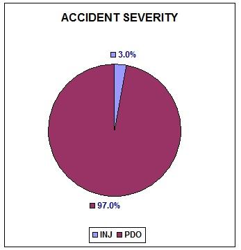
13 3.0 Crash History Narrative: Crash records for the most recent three-year crash history for the intersection of Lorain Road/Brookpark Road were obtained from the City of North Olmsted. The three-year period includes years 2007, 2008, and The crash records were examined to identify the types of crashes and to extract from the records narratives crash data for tabulation and further analysis. Crash record numbers, crash types, dates of crashes, times, contributing factors, and other relevant data were tabulated by year and shown in tables 1, 2, and 3 presented in Appendix A. There were 9, 14, and 10 crashes in years 2007, 2008, and 2009, respectively, for a total of 33 crashes in the three-year period. One crash was discounted for not being associated with the intersection. One crash involved a bicyclist riding on the sidewalk when the rider collided with a vehicle exiting from the driveway of the Speedway gas station. The other crash occurred on the one-lane, right-turn exit loop (slip ramp) when the driver attempted to overtake a vehicle proceeding ahead of him. Hence 31 of the 33 vehicular crashes occurred within the intersection and its three approaches. Nineteen or about 61% of the crashes were related to the driveway common to the Speedway gas station and the Boston Market restaurant. The predominant type of crash was rear end collision, followed by angle collision. No pedestrian crashes or incidents were reported. Crash statistics reveal that most crashes occur between the hours of about 12:00 p.m. and 3:00 p.m. Although there was only one crash that resulted in a minor injury, all other crashes were property damage only (PDO) crashes. The primary contributing factors appear to be driver inattention and failure to control or failure to yield. The heavy traffic movements, present lane configuration, alignment of the intersection, and the driveways controlled by a split phase by the same traffic control signal of the intersection are elements in drivers actions that cause driver inattention and failure to control or to yield. Rear end collisions, for example, usually occur due to sudden stops or slowdowns attributable to interference from adjacent driveways or due to sudden stops at the traffic control signals. Left-turn collisions, attributable to failure to yield, often occur due to the presence of points of conflict. 5854t 13

14 Crash Charts: Various charts were developed to present crash statistical data such as crashes by day of week, time of day, crash severity, and contributing factors. 5854t 14
 crashes.")

15 The charts below show that 97% of the crashes were property damage only (PDO) crashes. The majority of them occurred on dry pavement during daylight and clear weather conditions. Environmental factors, therefore, do not play a significant role in contributing to the occurrence of these crashes. 5854t 15

16 5854t 16
17 Collision Diagram: A collision diagram, shown below, was constructed to depict the types of crashes and to show their approximate relative locations. The collision diagram shows that most of the collisions occurred within and near the conjoined Boston Market restaurant/speedway gas station driveways that share the traffic signal-controlled intersection. There were 19 out of 31 crashes at and near the driveway, representing about 61% of the crashes. 5854t 17


18 4.0 Rank per ODOT Highway Safety Program (HSP) A segment of Lorain Road (SR10) between Butternut Ridge Road and Ranchview Avenue ranks 99 th in the State in ODOT s Highway Safety Program listing of roadway segments with the most crashes based on crash data for The table below shows the ranking among several other roadway segments in the ODOT District 12 region, which includes North Olmsted, and the map shows the extent of the segment, which also encompasses the intersection of Brookpark Road and Lorain Road. 5854t 18

19 5.0 Base Year 2010 Existing Traffic Volumes, Level of Service Criteria, and Present Level Of Service (LOS) for Alternative No Build Existing Traffic Volumes: Traffic volumes at this intersection for base year 2010 were counted in mid 2010, while schools were still in session, by a consultant hired by the City of North Olmsted. The intersection services about 27,565 vehicles per day. The following diagrams show the average daily traffic (ADT) and the am and pm peak-hour traffic volumes. 5854t 19
20 Level-of-Service (LOS) Criteria: The Level-of-Service (LOS) is a measure of how well an intersection operates under certain conditions such as traffic volumes, number of lanes and lane assignment, signal timing and phasing sequence, and lane widths among other things. Intersection LOS represents the vehicular delays when drivers stop at the intersection (stopped delay) to await a phase that gives them permission for the right of way, and then the time taken to prepare and begin to drive through it (start up lost time/delay). Intersection capacity analyses are used to calculate these delays using procedures outlined in the 2000 and 2010 Highway Capacity Manual published by the Transportation Research Board. The capacity analyses procedures provide calculated average vehicle delay in seconds per vehicle. This is based on traffic volumes, number of lanes, traffic control type, grade, channelization, and percent of heavy vehicles at each intersection. A range of average vehicle delay at the intersection is assigned a letter grade designation for Level-of-Service (LOS) ranging from A for best LOS to F for worst LOS. Intersection Level-of-Service designations and ranges of delay for signalized intersections, as defined by the Transportation Research Board, are shown in the Table below. LEVEL-OF-SERVICE DESIGNATION ( For Signalized Intersections) AVERAGE DELAY ( In Seconds/Vehicle) A <= 10.0 B C D E F > t 20

21 Present Level-of-Service (LOS): Level-of-Service (LOS) analyses for existing conditions were conducted to estimate the quality of operation of the intersection and to describe its ability to deliver service. The overall level of operation of the intersection of Lorain Road and Brookpark Road in the a.m. and p.m. peak periods under existing traffic, geometric, signal timing, and signal phasing conditions is estimated to be LOS C based on the present restrictive phasing sequence. The LOS based on a best case scenario with the least restrictive or most effective phase sequence would be B. Level-of-Service D is considered borderline satisfactory for intersections in urbanized areas, but LOS E and below are considered unsatisfactory or failure condition. The following diagram and LOS table show the results of the LOS analyses. ALTERNATIVE NO-BUILD INTERSECTION LEVEL-OF-SERVICE BASE YEAR 2010 EXISTING CONDITIONS Lorain Rd/Brookpark Rd Approach AM Peak PM Peak Delay Level-of-Service Delay Level-of-Service Lorain Road Northeast Bound Lorain Road Southwest Bound Brookpark Road Westbound Speedway/Boston Market Driveways 11.1 A 17.6 B 19.9 B 25.8 C 12.8 B 19.5 B 29.0 C 30.5 C Intersection 14.4 B 18.7 B 5854t 21

22 6.0 Forecast Year 2030 Traffic Volumes and Level of Service (LOS) for Alternative No Build Level-of-Service (LOS) with the existing geometry in forecast year 2030 will be the same as the LOS for base year 2010 existing conditions because the traffic volumes and directional movements are expected to remain about the same. NOACA s Regional Transportation Model was used to determine whether there will be any future change in the traffic volumes. No growth is forecast for the area for the near or long term. Current population, land use, socioeconomic conditions, and automobile ownership are expected to remain relatively constant. The traffic patterns and travel demands in year 2030 are expected to mimic current conditions. 7.0 Proposed Realignment The City of North Olmsted would like to realign a section of the divided four-lane Brookpark Road with Silverdale Road at its intersection with Lorain Road. This proposed realignment, shown in the schematic diagram below, takes advantage of the existing available right-of-way, and the potential low cost, short term implementation attributes of this possible solution. Two possible lane configuration alternatives were developed to cater to this proposed realignment. Schematic Diagram of Proposed Realignment Presented By the City of North Olmsted 5854t 22

23 8.0 Possible Lane Configuration Alternatives In consultation and discussion with the City of North Olmsted, two possible lane configuration alternatives were chosen for consideration from among several preliminary ones previously explored, besides Alternative No- Build described earlier. Alternative 1 lane configuration consists of a two-lane, one-way Brookpark Road westbound approach that terminates at the Silverdale Road intersection with Lorain Road. It (Alternative 1) maintains the Brookpark two through-lanes at their original intersection with Lorain Road for the right-turn traffic movement from Lorain Road to Brookpark Road eastbound. Alternative 2 lane configuration, on the other hand, provides for one Brookpark through-lane eastbound at the intersection with Silverdale Road and Lorain Road. It (Alternative 2) maintains one Brookpark through-lane at its original intersection with Lorain Road for the right-turn traffic movement from Lorain Road to Brookpark Road eastbound. Alternatives 1 and 2, and the Level-of-Service associated with them are described in more detail in the following sections. 9.0 Alternative 1 Lane Configuration Alternative 1 lane configuration, shown in the diagram below, consists of a two-lane, one-way approach from Brookpark Road at Silverdale Lorain Roads. One of the lanes will be designated as exclusive left-turn bay, and the other will be assigned for left and through traffic movements. Silverdale Road will be modified from its present one lane approach shared by the left and right turn movements to a two-lane approach with two exclusive turn bays for each turn movement separately. 5854t 23
 for the intersection for Alternative 1 Lane-Configuration under both base year 2010 and forecast year 2030 traffic and signal timing and phasing conditions will be B in the am peak period and C")
24 Level-of-Service for Alternative1 Lane-Configuration for Base Year 2010 and Forecast Year 2030 Traffic Volumes and Traffic Control Signal Timing and Phasing Conditions The overall Level-of-Service (LOS) for the intersection for Alternative 1 Lane-Configuration under both base year 2010 and forecast year 2030 traffic and signal timing and phasing conditions will be B in the am peak period and C in the pm peak period. Forecast year 2030 LOS will be similar to existing Base year 2010 LOS, as there will be no change in the traffic volumes and traffic movement patterns. The following LOS diagram and table show the LOS for all group movements, approaches, and overall intersection operation. ALTERNATIVE 1 LANE-CONFIGURATION INTERSECTION LEVEL-OF-SERVICE BASE YEAR 2010 and FORECAST YEAR 2030 CONDITIONS Lorain Rd/Brookpark Rd Approach Delay Delay PM Peak Level-of-Service Lorain Road, Northeast Bound 18.6 B 19.2 B Lorain Road, Southwest Bound 19.5 B 22.0 C Brookpark Road, Westbound 17.7 B 25.8 C Silverdale Road, Southbound 15.9 B 17.7 B 18.6 B 22.0 C Intersection 5854t AM Peak Level-of-Service 24
25 10.0 Alternative 2 Lane Configuration Alternative 2 lane configuration, shown in the diagram below, provides for a two-way traffic movement at Brookpark Road at its intersection with Silverdale and Lorain Roads. It consists of a two-lane approach from Brookpark Road westbound at Lorain Road, and one receiving lane eastbound. The westbound Brookpark Road approach will have one lane assigned exclusively for left-turn traffic movement and one lane assigned for shared left and through traffic movements. Brookpark Road will also maintain one through lane at its original intersection with Lorain Road for right-turn traffic from Lorain Road to Brookpark Road eastbound. Silverdale Road, however, will be modified from its present one lane shared right, through, and left-turn approach to a two-lane approach with one lane for an exclusive left-turn bay and one shared lane for right- and through-traffic movements. A left-turn movement from Lorain Road westbound to Lorain Road eastbound was precluded at this juncture at the behest of the City of North Olmsted pending examination at the design stage by the City to determine whether it would be geometrically feasible to provide for it. If providing for left-turn is found to be feasible, a left-turn movement may be allowed to take advantage of space available for an exclusive left-turn bay. 5854t 25

26 Level-of-Service for Alternative2 Lane Configuration for Base Year 2010 and Forecast Year 2030 Traffic Volumes and Traffic Control Signal Timing and Phasing Conditions The Level-of-Service (LOS) for Alternative 2 lane configuration is B in the am peak period and C in the pm peak period. The LOS for Base Year 2010 and Forecast Year 2030 will be the same because the traffic volumes are expected to remain about the same. INTERSECTION LEVEL-OF-SERVICE FOR ALTERNATIVE 2 LANE-CONFIGURATION FOR BASE YEAR 2010 and FORECAST YEAR 2030 CONDITIONS Lorain Rd/Brookpark Rd Approach AM Peak PM Peak Delay Level-of-Service Delay Level-of-Service Lorain Road SW, Northeast Bound Lorain Road NE, Southwest Bound Brookpark Road, West Bound Silverdale Road, South Bound 18.6 B 19.4 B 17.7 B 15.7 B 19.2 B 22.0 C 25.8 C 21.3 C Intersection 18.5 B 22.1 C 5854t 26
27 11.0 Findings, Conclusions, and Recommendations Findings and Conclusions: The results of the study support the idea of realigning a section of Brookpark Road with Silverdale to eliminate its intersection with Lorain Road at the conjoined driveways on the northern side of Lorain Road of the Speedway gas station and Boston Market restaurant. The signalized intersection to be eliminated is too closely spaced to the intersection of Silverdale at Lorain Road, and is controlled by a phasing sequence that contains two split phases. The T-Intersection of Silverdale Road with Lorain Road, by virtue of its proximity to the existing signalized intersection to be eliminated, is also controlled by split phases. The proposed realignment provides for eliminating all split phasing and enables the free flow of right-turning traffic from the Lorain Road eastbound approach to eastbound Brookpark Road. Such modification will improve the operation of the intersection and increase its overall Level- of-service. The present alignment of Lorain Road and the characteristics of the landscape within which the proposed realignment of Brookpark Road with Silverdale Road might be implemented may continue to present physical constraints that may prevent the production of an alignment free from sharp oblique angles between Lorain Road and Brookpark Road. Such oblique angles, depending on how acutely, may not provide the needed curvature or turning radius to allow for a left turn movement from the Lorain Road westbound approach onto Brookpark Road eastbound to take advantage of the existing left turn bay on the Lorain Road westbound approach. The feasibility of securing the needed turning radius or curvature should be investigated for Alternative 2 at the design stage. Recommendations: Based on the aforementioned findings and conclusions, and by further examination of the general landscape of the area in the vicinity of the intersection of Lorain Road with Brookpark Road and Silverdale Road, it is recommended to consider and examine realigning Brookpark Road with Canterbury at its intersection with Lorain Road, either as a substitute to the realignment proposed earlier and described in this study report or in lieu of it at some point in time in the long term. The following lane-configuration options are presented for consideration and further analyses: 5854t 27

28 Option1 Option2 5854t 28
29 APPENDICES 1. APPENDIX A: Crash Records Summary Tables (Attached with report) 2. APPENDIX B: Level of Service (LOS) Calculations Worksheets (Bound Separately) 5854t 29
30 APPENDIX A Crash Records Summary Tables Order # Table 1: Crashes in Year 2007 at the Intersection of Lorain Rd/Brookpark Rd Crash Record Date of Crash Day of week Time of Crash Type of Crash Severity of Crash 1 T /15/07 Monday 12:23 Rear End PDO Wet Pavement Contributing Factor 2 T /26/07 Friday 21:56 Angle Injury Interference from Driveway 3 T /19/07 Monday 13:10 Rear End PDO 4 T /23/07 Friday 12:17 Rear End PDO Failure to Maintain Assured Clear Distance Failure to Stop 5 T /08/07 Friday 12:13 Rear End PDO Failure to Control Due to Slippery Surface 6 T /08/07 Sunday 13:04 Angle PDO Inattention: Coming out of Private Driveway to Main Rd 7 T /31/07 Tuesday 13:40 Rear End PDO Failure to Control 8 T /20/07 Thursday 12:07 Bicyclist Not Reported 9 T /23/07 Friday 15:54 Angle PDO PDO: Property Damage Only Failure to Yield: Vehicle - Bicycle Collision on Sidewalk Failure to Obey Traffic Control Signal 5854t 30
31 Table 2: Crashes in Year 2008 at the Intersection of Lorain Rd/Brookpark Rd Order # Crash Record Date of Crash Day of week Time of Crash Type of Crash Severity of Crash Contributing Factor 1 T /04/08 Friday 15:12 Rear End PDO Inattention 2 T /13/08 Sunday 14:38 Angle PDO Inattention 3 T /13/08 Sunday 16:14 Rear End PDO Inattention 4 T /01/08 Friday 14:11 Angle PDO Failure to Yield 5 T /10/08 Sunday 12:20 Angle PDO Inattention 6 T /15/08 Friday 13:55 Rear End PDO Failure to Control / Reckless Driving 7 T /11/08 Friday 14:22 Rear End PDO Failure to Control / Following Too Closely 8 T /26/08 Saturday 19:17 Rear End PDO Inattention 9 T /04/08 Sunday 14:28 Passing Sideswipe PDO Inattention 10 T /13/08 Friday 14:27 Angle PDO Failure to Yield / Interference from Private Driveway 11 T /26/08 Saturday 11:51 Angle PDO Failure to Yield / Interference from Private Driveway 12 T /31/08 Friday 14:44 Passing Sideswipe PDO Inattention 13 T /05/08 Wednesday 10:32 Angle PDO Failure to Yield 14 T /09/08 Tuesday 17:45 Rear End PDO Inattention / Reckless Driving PDO: Property Damage Only 5854t 31
32 Order # Table 3: Crashes in Year 2009 at the Intersection of Lorain Rd/Brookpark Rd Crash Record Date of Crash Day of week Time of Crash Type of Crash Severity of Crash Contributing Factor 1 T /10/09 Saturday 11:40 Rear End PDO Inattention / Following too closely 2 T /27/09 Tuesday 19:11 Rear End PDO Inattention / Following too closely 3 T /04/09 Wednesday 14:29 Angle PDO Failure to yield 4 T /26/09 Thursday 19:46 Rear End PDO Inattention / Following too closely 5 T /18/09 Saturday 16:20 Rear End PDO Inattention 6 T /09/09 Saturday 10:17 Angle PDO Failure to yield 7 T /21/09 Friday 11:52 Rear End PDO Failure to Control / Mechanical Failure 8 T /12/09 Saturday 17:00 Angle PDO Failure to yield 9 T /26/09 Saturday 16:15 Rear End PDO Failure to Control / Following too Closely 10 T /29/09 Tuesday 12:09 Angle PDO Failure to yield 5854t 32
33 APPENDIX B Level-of-Service (LOS) Calculations Worksheets Lorain Road/Brookpark Road For Alternative No-Build (Existing Conditions) AM & PM Peak Periods Alternative 1 Lane-Configuration (Build Conditions) AM & PM Peak Periods & Alternative 2 Lane-Configuration (Build Conditions) AM & PM Peak Periods BOUND SEPARATELY Available Upon Request 5854t 33
Traffic Impact Study. Westlake Elementary School Westlake, Ohio. TMS Engineers, Inc. June 5, 2017
 TMS Engineers, Inc. Traffic Impact Study Westlake Elementary School Westlake, Ohio June 5, 2017 Prepared for: Westlake City Schools - Board of Education 27200 Hilliard Boulevard Westlake, OH 44145 TRAFFIC
TRANSPORTATION ANALYSIS REPORT US Route 6 Huron, Erie County, Ohio
 TRANSPORTATION ANALYSIS REPORT US Route 6 Huron, Erie County, Ohio December 12, 2012 Prepared for: The City of Huron 417 Main Huron, OH 44839 Providing Practical Experience Technical Excellence and Client
Evaluation of M-99 (Broad Street) Road Diet and Intersection Operational Investigation
 Road Diet and Intersection Operational Investigation") Evaluation of M-99 (Broad Street) Road Diet and Intersection Operational Investigation City of Hillsdale, Hillsdale County, Michigan June 16, 2016 Final Report Prepared for City of Hillsdale 97 North Broad
Evaluation of M-99 (Broad Street) Road Diet and Intersection Operational Investigation City of Hillsdale, Hillsdale County, Michigan June 16, 2016 Final Report Prepared for City of Hillsdale 97 North Broad
Glenn Avenue Corridor Traffic Operational Evaluation
 Glenn Avenue Corridor Traffic Operational Evaluation PREPARED FOR: THE CITY OF AUBURN PREPARED BY: DECEMBER 2007 Glenn Avenue Corridor Study--Auburn, Alabama TABLE OF CONTENTS Introduction... 1 Background
TRAFFIC IMPACT STUDY And A TRAFFIC SIGNAL WARRANT ANALYSIS FOR A SENIOR LIVING AND APARTMENT DEVELOPMENT
 TRAFFIC IMPACT STUDY And A TRAFFIC SIGNAL WARRANT ANALYSIS FOR A SENIOR LIVING AND APARTMENT DEVELOPMENT DEERFIELD TOWNSHIP, WARREN COUNTY, OHIO Nantucket Circle and Montgomery Road () Prepared for: ODLE
Highway 49, Highway 351 and Highway 91 Improvements Feasibility Study Craighead County
 Highway 49, Highway 351 and Highway 91 Improvements Feasibility Study Craighead County Executive Summary March 2015 Highway 49, Highway 351 and Highway 91 Improvements Feasibility Study Craighead County
Improving Cyclist Safety at the Dundas Street West and Sterling Road Intersection
 STAFF REPORT ACTION REQUIRED Improving Cyclist Safety at the Dundas Street West and Sterling Road Intersection Date: August 17, 2012 To: From: Wards: Reference Number: Public Works and Infrastructure Committee
Donahue Drive Corridor Traffic Operational Evaluation
 Donahue Drive Corridor Traffic Operational Evaluation PREPARED FOR: THE CITY OF AUBURN PREPARED BY: JANUARY 2007 Donahue Drive Corridor Study--Auburn, Alabama TABLE OF CONTENTS Introduction... 1 Background
Traffic Circulation Study for Neighborhood Southwest of Mockingbird Lane and Airline Road, Highland Park, Texas
 ARIZONA TEXAS NEW MEXICO OKLAHOMA February 13, 2015 Mr. Meran Dadgostar P.E., R.S. Town of Highland Park 4700 Drexel Dr. Highland Park, Texas 75205 Re: Traffic Circulation Study for Neighborhood Southwest
A plan for improved motor vehicle access on Railroad Avenue in Provincetown
 A plan for improved motor vehicle access on Railroad Avenue in Provincetown February 2011 A plan for improved motor vehicle access on Railroad Avenue in Provincetown INTRODUCTION AND PROBLEM IDENTIFICATION
Highway 111 Corridor Study
 Highway 111 Corridor Study June, 2009 LINCOLN CO. HWY 111 CORRIDOR STUDY Draft Study Tea, South Dakota Prepared for City of Tea Sioux Falls Metropolitan Planning Organization Prepared by HDR Engineering,
Traffic Impact Analysis Walton Acres at Riverwood Athletic Club Clayton, NC
 Traffic Impact Analysis Walton Acres at Riverwood Athletic Club Clayton, NC 1. TABLE OF CONTENTS INTRODUCTION...1 1.1. Site Location and Study Area...1 1.2. Proposed Land Use and Site Access...2 1.3.
Capital Region Council of Governments
 March 23, 2018 Capital Region Council of Governments PROJECT CONCEPT REPORT Realignment of Swamp and Northfield Road s approaches to Route 44 (Boston Turnpike) Town of Coventry SUMMARY: The Town of Coventry
Project Report. South Kirkwood Road Traffic Study. Meadows Place, TX October 9, 2015
 Meadows Place, TX October 9, 2015 Contents 1 Introduction... 1 2 Data Collection... 1 3 Existing Roadway Network... 2 4 Traffic Volume Development... 2 5 Warrant Analysis... 3 6 Traffic Control Alternative
METHODOLOGY. Signalized Intersection Average Control Delay (sec/veh)
") Chapter 5 Traffic Analysis 5.1 SUMMARY US /West 6 th Street assumes a unique role in the Lawrence Douglas County transportation system. This principal arterial street currently conveys commuter traffic
Chapter 5 Traffic Analysis 5.1 SUMMARY US /West 6 th Street assumes a unique role in the Lawrence Douglas County transportation system. This principal arterial street currently conveys commuter traffic
TRAFFIC IMPACT STUDY COMPREHENSIVE UPDATE TOWN OF THOMPSON S STATION, TENNESSEE PREPARED FOR: THE TOWN OF THOMPSON S STATION
 TRAFFIC IMPACT STUDY COMPREHENSIVE UPDATE TOWN OF THOMPSON S STATION, TENNESSEE PREPARED FOR: THE TOWN OF THOMPSON S STATION Transportation Consultants, LLC 1101 17 TH AVENUE SOUTH NASHVILLE, TN 37212
5858 N COLLEGE, LLC N College Avenue Traffic Impact Study
 5858 N COLLEGE, LLC nue Traffic Impact Study August 22, 2016 Contents Traffic Impact Study Page Preparer Qualifications... 1 Introduction... 2 Existing Roadway Conditions... 5 Existing Traffic Conditions...
INTERSECTION SAFETY STUDY State Route 57 / Seville Road
 INTERSECTION SAFETY STUDY State Route 57 / Seville Road City of Wadsworth, Medina County, Ohio Prepared For: City of Wadsworth Engineering Department 120 Maple Street Wadsworth, OH 44281 Prepared By: GPD
DEPARTMENT OF ENVIRONMENTAL SERVICES. North Harrison Street (Lee Highway to Little Falls Road) Comparative Analysis. Prepared for:
 Comparative Analysis. Prepared for:") DEPARTMENT OF ENVIRONMENTAL SERVICES North Harrison Street (Lee Highway to Little Falls Road) Comparative Analysis Prepared for: Arlington County Department of Environmental Services 2100 Clarendon Boulevard,
DEPARTMENT OF ENVIRONMENTAL SERVICES North Harrison Street (Lee Highway to Little Falls Road) Comparative Analysis Prepared for: Arlington County Department of Environmental Services 2100 Clarendon Boulevard,
Truck Climbing Lane Traffic Justification Report
 ROUTE 7 (HARRY BYRD HIGHWAY) WESTBOUND FROM WEST MARKET STREET TO ROUTE 9 (CHARLES TOWN PIKE) Truck Climbing Lane Traffic Justification Report Project No. 6007-053-133, P 101 Ι UPC No. 58599 Prepared by:
Intersection Traffic Control Feasibility Study
 Intersection Traffic Control Feasibility Study CSAH 9 at CSAH 60 (185th Avenue) Prepared For: Dakota County Transportation Department Western Service Center 14955 Galaxie Avenue, 3rd Floor Apple Valley,
THIS PAGE LEFT BLANK INTENTIONALLY
 GA SR 25 Spur at Canal Road Transportation Impact Analysis PREPARED FOR GLYNN COUNTY, GEORGIA 1725 Reynolds Street, Suite 300 Brunswick, Georgia 31520 PREPARED BY 217 Arrowhead Boulevard Suite 26 Jonesboro,
Draft Report. Traffic Impact Study. Superstore, Wal-Mart, and Kent Development. Yarmouth, Nova Scotia. Prepared for
 oad & Traffic Management Road & Traffic Management R Atlantic Traffic Engineering Specialists Draft Report Traffic Impact Study Superstore, Wal-Mart, and Kent Development Yarmouth, Nova Scotia Prepared
Chapter 4 Traffic Analysis
 Chapter 4 Traffic Analysis PURPOSE The traffic analysis component of the K-68 Corridor Management Plan incorporates information on the existing transportation network, such as traffic volumes and intersection
Traffic Impact Analysis Chatham County Grocery Chatham County, NC
 Chatham County Grocery Chatham County, NC TABLE OF CONTENTS 1. INTRODUCTION... 1 1.1. Location and Study Area... 1 1.2. Proposed Land Use and Access... 2 1.3. Adjacent Land Uses... 2 1.4. Existing ways...
MEMORANDUM. DATE March 1, 2012 TO Town of Milton Mark Abbott, Seth Asante, and Efi Pagitsas Boston Region MPO Staff
 MEMORANDUM DATE March 1, 212 TO Town of Milton FROM RE Mark Abbott, Seth Asante, and Efi Pagitsas Boston Region MPO Staff FFY 211 Safety and Operations Analyses at Selected Boston Region MPO Intersections:
Existing Conditions. Date: April 16 th, Dan Holderness; Coralville City Engineer Scott Larson; Coralville Assistant City Engineer
 Date: April 16 th, 2015 To: From: Re: Dan Holderness; Coralville City Engineer Scott Larson; Coralville Assistant City Engineer Darian Nagle-Gamm, Traffic Engineering Planner Highway 6 (2 nd Street) /
5.0 Roadway System Plan
 Southwest Boise Transportation Study Page 16 5.0 Roadway System Plan The Roadway System Plan outlines roadway improvements in the Initial Study Area. It forecasts future deficiencies on the arterial system,
TOWN OF CHAPEL HILL POLICY AND PROCEDURES FOR TRAFFIC CALMING MEASURES
 TOWN OF CHAPEL HILL POLICY AND PROCEDURES FOR TRAFFIC CALMING MEASURES (Adopted by the Town Council on June 30, 2004) (Revised December 6, 2010) (Revised February 8, 2016) POLICY AND PROCEDURES FOR TRAFFIC
Transportation Impact Study for Abington Terrace
 Transportation Impact Study for Abington Terrace Abington Township, Montgomery County, PA Sandy A. Koza, P.E., PTOE PA PE License Number PE059911 Prepared by McMahon Associates, Inc. 425 Commerce Drive,
Walmart (Store # ) 60 th Street North and Marion Road Sioux Falls, South Dakota
 60 th Street North and Marion Road Sioux Falls, South Dakota") Walmart (Store #4865-00) 60 th Street North and Marion Road Sioux Falls, South Dakota Prepared for: Wal-Mart Stores, Inc. Bentonville, Arkansas Prepared by: Kimley-Horn and Associates, Inc. ã2013 Kimley-Horn
Walmart (Store #4865-00) 60 th Street North and Marion Road Sioux Falls, South Dakota Prepared for: Wal-Mart Stores, Inc. Bentonville, Arkansas Prepared by: Kimley-Horn and Associates, Inc. ã2013 Kimley-Horn
Purpose: Financial Implications and Impact Statement: It is estimated that the cost to implement:
 Various Modifications Lower Jarvis Street and Lake Shore Boulevard East; Lower Jarvis Street, east side, between Lake Shore Boulevard East and The Esplanade - 45-77 Lower Jarvis Street; and Lower Jarvis
Route 28 (South Orleans Road)/Route 39 (Harwich Road)/Quanset Road Intersection
/Route 39 (Harwich Road)/Quanset Road Intersection") TRAFFIC FEASIBILITY STUDY Route 28 (South Orleans Road)/Route 39 (Harwich Road)/Quanset Road Intersection Orleans, Massachusetts Prepared for: Town of Orleans Prepared by: Fay, Spofford & Thorndike, LLC
TRAFFIC FEASIBILITY STUDY Route 28 (South Orleans Road)/Route 39 (Harwich Road)/Quanset Road Intersection Orleans, Massachusetts Prepared for: Town of Orleans Prepared by: Fay, Spofford & Thorndike, LLC
Walton Acres at Riverwood Athletic Club Clayton, North Carolina
 9. CONCLUSIONS This Traffic Impact Analysis Update was conducted to determine the potential traffic impacts of the proposed Walton Acres at Riverwood Athletic Club residential development, located east
Comments EXECUTIVE SUMMARY
 Comments 1. Under any Alternatives, MCDOT should provide better at-grade pedestrian crossing of Georgia Avenue and Forest Glen Road, including improved crosswalks with wider medians and adequate signal
1609 E. FRANKLIN STREET HOTEL TRAFFIC IMPACT STUDY EXECUTIVE SUMMARY
 1609 E. FRANKLIN STREET HOTEL TRAFFIC IMPACT STUDY EXECUTIVE SUMMARY Prepared for: The Town of Chapel Hill Public Works Department Traffic Engineering Division Prepared by: HNTB North Carolina, PC 343
Co-ordinator Transportation Committee. Director, Mobility Services and Corporate Fleet Services Environment and Transportation Department
 28 REGIONAL MUNICIPALITY OF OTTAWA-CARLETON MUNICIPALITÉ RÉGIONALE D OTTAWA-CARLETON REPORT RAPPORT Our File/N/Réf. Your File/V/Réf. 25 23-97-R016 DATE 15 April 1997 TO/DEST. FROM/EXP. SUBJECT/OBJET Co-ordinator
Executive Summary June 2015
 Executive Summary June 2015 Highway 112 Corridor Study Benton and Washington Counties Executive Summary June 2015 Prepared by Transportation Planning and Policy Division Arkansas State Highway and Transportation
TRAFFIC IMPACT ANALYSIS
 TRAFFIC IMPACT ANALYSIS FOR THE CHAMPAIGN UNIT#4 SCHOOL DISTRICT PROPOSED HIGH SCHOOL (SPALDING PARK SITE) IN THE CITY OF CHAMPAIGN Final Report Champaign Urbana Urbanized Area Transportation Study 6/24/2014
Traffic Study of Fuller Street, Cady Street, West Street and West Avenue. Final Report
 Traffic Study of Fuller Street, Cady Street, West Street and West Avenue Final Report July 2005 Prepared for: Town of Ludlow Prepared by: Pioneer Valley Planning Commission 26 Central Street West Springfield,
Recommended Roadway Plan Section 2 - Land Development and Roadway Access
 Recommended Roadway Plan Section 2 - Land Development and Roadway Access SECTION 2 Land Development and Roadway Access 2.1 Land Use and Access Management The Federal Highway Administration (FHWA) defines
#!! "$% ##! &! # '#! % $ #!
 Executive Summary US Highway 16 (US 16) is the primary corridor connecting Rapid City to the Black Hills region. It serves a growing population of commercial and residential traffic, as well as seasonal
DRAFT. Corridor study. Honeysuckle Road. October Prepared for the City of Dothan, AL. Prepared by Gresham, Smith and Partners
 DRAFT Corridor study Honeysuckle Road October 2017 Prepared for the City of Dothan, AL Prepared by TABLE OF CONTENTS SECTION I... 1 STUDY SUMMARY... 1 INTRODUCTION... 1 CONCLUSIONS... 5 SECTION II... 7
INDUSTRIAL BUILDING 3009 HAWTHORNE ROAD CITY OF OTTAWA TRANSPORTATION OVERVIEW REVISED. Prepared for: Canada Inc.
 INDUSTRIAL BUILDING 3009 HAWTHORNE ROAD CITY OF OTTAWA TRANSPORTATION OVERVIEW REVISED Prepared for: 7849648 Canada Inc. Octiober 1, 2015 114-598 Overview_2.doc D. J. Halpenny & Associates Ltd. Consulting
OTTAWA TRAIN YARDS PHASE 3 DEVELOPMENT CITY OF OTTAWA TRANSPORTATION IMPACT STUDY. Prepared for:
 OTTAWA TRAIN YARDS PHASE 3 DEVELOPMENT CITY OF OTTAWA TRANSPORTATION IMPACT STUDY Prepared for: The Ottawa Train Yards Inc. 223 Colonnade Road South, Suite 212 Nepean, Ontario K2E 7K3 January 17, 2012
FINAL DESIGN TRAFFIC TECHNICAL MEMORANDUM
 FINAL DESIGN TRAFFIC TECHNICAL MEMORANDUM July 2014 FINAL (SR 43) Project Development and Environment Study From State Road 60 (Adamo Drive) to I-4 (SR 400) Hillsborough County, Florida Work Program Item
CITY OF SASKATOON COUNCIL POLICY
 ORIGIN/AUTHORITY Clause 1, Report No. 1-1980 and Clause 4, Report No. 22-1990 of the Works and Utilities Committee; Clause 6, Report No. 17-2004 of the Planning and Operations Committee; and Clause D5,
Please find below the Town staff s responses to NCDOT s recommended roadway stipulations listed in a letter dated May 25, 2015.
 TOWN OF CHAPEL HILL Public Works Department 6850 Millhouse Road Chapel Hill, NC 27516-8173 phone (919) 969-5100 fax (919) 969-2003 www.townofchapelhill.org TO: FROM: Chuck Edwards, NCDOT Division 7 District
M-58 HIGHWAY ACCESS MANAGEMENT STUDY Mullen Road to Bel-Ray Boulevard. Prepared for CITY OF BELTON. May 2016
 M-58 HIGHWAY ACCESS MANAGEMENT STUDY Prepared for CITY OF BELTON By May 2016 Introduction Missouri State Highway 58 (M-58 Highway) is a major commercial corridor in the City of Belton. As development has
List of Attachments. Location Map... Site Plan... City of Lake Elsinore Circulation Element... City of Lake Elsinore Roadway Cross-Sections...
 List of Attachments Exhibits Location Map... Site Plan... City of Lake Elsinore Circulation Element... City of Lake Elsinore Roadway Cross-Sections... Existing Lane Geometry and Traffic Controls... Existing
QUICKIE C STORE AND GAS BAR 1780 HERON ROAD OTTAWA, ONTARIO TRANSPORTATION BRIEF. Prepared for:
 QUICKIE C STORE AND GAS BAR 1780 HERON ROAD OTTAWA, ONTARIO TRANSPORTATION BRIEF Prepared for: Quickie Convenience Stores Larny Holdings Ltd. c/o PBC Group April 15, 2015 115-615 Report_1.doc D. J. Halpenny
OFFICE/RETAIL DEVELOPMENT 1625 BANK STREET OTTAWA, ONTARIO TRANSPORTATION BRIEF. Prepared for: Canada Inc.
 OFFICE/RETAIL DEVELOPMENT 1625 BANK STREET OTTAWA, ONTARIO TRANSPORTATION BRIEF Prepared for: 9402209 Canada Inc. December 15, 2015 115-625 Report_2.doc D. J. Halpenny & Associates Ltd. Consulting Transportation
Figure 1: Vicinity Map of the Study Area
 ARIZONA TEXAS NEW MEXICO OKLAHOMA May 5, 2016 Mr. Anthony Beach, P.E. BSP Engineers 4800 Lakewood Drive, Suite 4 Waco, Texas 76710 Re: Intersection and Access Analysis along Business 190 in Copperas Cove
Los Altos Hills Town Council - June 18, 2015 Palo Alto City Council June 22, AGENDA ITEM #2.B Presentation
 Los Altos Hills Town Council - June 18, 2015 Palo Alto City Council June 22, 2015 AGENDA ITEM #2.B Presentation Previous Presentations Los Altos Hills Town Council in May 2014 and February 2015 Palo Alto
Figure 1: East West Connector Alignment Alternatives Concept Drawing
 Page 2 of 9 Figure 1: East West Connector Alignment Alternatives Concept Drawing The Montebello Drive extension will run north south and connect Wilsonville Road to the Boones Ferry Road to Brown Road
Multi-Modal Traffic Analysis. Parisi and Associates
 Mill Valley to Corte Madera Bicycle and Pedestrian Corridor Study Appendix D: Multi-Modal Traffic Analysis Prepared by Parisi and Associates August 2009 Appendix D - Multi-Modal Traffic Analysis Table
INTRODUCTION THOROUGHFARE SYSTEM CLASSIFICATIONS
 INTRODUCTION The thoroughfare plan will assist public officials in the development of a specialized system for efficient and safe movement of vehicular traffic while minimizing potential conflicts with
Chapter 2: Standards for Access, Non-Motorized, and Transit
 Standards for Access, Non-Motorized, and Transit Chapter 2: Standards for Access, Non-Motorized, and Transit The Washtenaw County Access Management Plan was developed based on the analysis of existing
ALLEY 24 TRAFFIC STUDY
 ALLEY 24 TRAFFIC STUDY in City of Frostburg, Maryland January 2013 3566 Teays Valley Road Hurricane, WV Office: (304) 397-5508 www.denniscorporation.com Alley 24 Traffic Study January 2013 Frostburg, Maryland
Roundabout Feasibility Memorandum
 Roundabout Feasibility Memorandum To From Gwen Pipkin Bill Howell Date June 18, 2013 Subject Roundabout Feasibility Study SR 29 PD&E Study From Oil Well Road to SR 82 Collier County, FL FPID 417540-1-22-01
TRAFFIC STUDY GUIDELINES Clarksville Street Department
 TRAFFIC STUDY GUIDELINES Clarksville Street Department 9/1/2009 Introduction Traffic studies are used to help the city determine potential impacts to the operation of the surrounding roadway network. Two
HILTON GARDEN INN HOTEL HOTEL EXPANSION 2400 ALERT ROAD, OTTAWA TRANSPORTATION BRIEF. Prepared for:
 HILTON GARDEN INN HOTEL HOTEL EXPANSION 2400 ALERT ROAD, OTTAWA TRANSPORTATION BRIEF Prepared for: Bona Building & Management Co. Ltd. Place Vanier, 333 North River Road Vanier, Ontario K1L 8B9 October
Operational Comparison of Transit Signal Priority Strategies
 Operational Comparison of Transit Signal Priority Strategies Revision Submitted on: November, 0 Author: Adriana Rodriguez, E.I Assistant Engineer Parsons Brinckerhoff 0 South Orange Avenue, Suite 00 Orlando,
Traffic Analysis and Design Report. NW Bethany Boulevard. NW Bronson Road to NW West Union Road. Washington County, Oregon
 Traffic Analysis and Design Report NW Bethany Boulevard NW Bronson Road to NW West Union Road Washington County, Oregon May 2011 Table of Contents Table of Contents Section 1 Executive Summary... 2 Section
Date: 09/22/2016 Subject: To: From: PennDOT Engineering District 5-0. Dear Applicant,
 Date: 09/22/2016 Subject: Highway Occupancy Permit Application No. 112807 Returned For Revisions To: Wal-Mart Real Estate Business Trust 2001 SE 10th Street Bentonville, AR 72716 From: PennDOT Engineering
City of Prince Albert Statement of POLICY and PROCEDURE. Department: Public Works Policy No. 66. Section: Transportation Issued: July 14, 2014
 Page: 1 of 8 1 POLICY 1.01 The City shall follow all of the specifications in the Manual of Uniform Traffic Control Devices for Canada, prepared by the National Committee of Uniform Traffic Control, and
Chapter 5 DATA COLLECTION FOR TRANSPORTATION SAFETY STUDIES
 Chapter 5 DATA COLLECTION FOR TRANSPORTATION SAFETY STUDIES 5.1 PURPOSE (1) The purpose of the Traffic Safety Studies chapter is to provide guidance on the data collection requirements for conducting a
Appendix B. Environmental Resource Technical Memorandum. Assessment on Travel Pattern and Access Impacts
 Appendix B Environmental Resource Technical Memorandum Assessment on Travel Pattern and Access Impacts TECHNICAL MEMORANDUM ENVIRONMENTAL RE-EVALUATION FOR UNION STATION TO OAK CLIFF DALLAS STREETCAR To:
HOLIDAY INN HOTEL 235 KING EDWARD AVENUE CITY OF OTTAWA TRANSPORTATION BRIEF. Prepared for:
 HOLIDAY INN HOTEL 235 KING EDWARD AVENUE CITY OF OTTAWA TRANSPORTATION BRIEF Prepared for: Momentum Planning & Communications 1165 Greenlawn Crescent Ottawa, ON K1L 6C2 June 29, 2015 115-618 Brief_1.doc
ENHANCED PARKWAY STUDY: PHASE 2 CONTINUOUS FLOW INTERSECTIONS. Final Report
 Preparedby: ENHANCED PARKWAY STUDY: PHASE 2 CONTINUOUS FLOW INTERSECTIONS Final Report Prepared for Maricopa County Department of Transportation Prepared by TABLE OF CONTENTS Page EXECUTIVE SUMMARY ES-1
Troutbeck Farm Development
 Troutbeck Farm Development Willistown Township, Chester County PA For Submission To: Willistown Township Last Revised: October, 4 TPD# INLM.A. 5 E. High Street Suite 65 Pottstown, PA 9464 6.36.3 TPD@TrafficPD.com
4. ENVIRONMENTAL IMPACT ANALYSIS 9. TRANSPORTATION AND TRAFFIC
 4. ENVIRONMENTAL IMPACT ANALYSIS 9. TRANSPORTATION AND TRAFFIC 4.9.1 INTRODUCTION The following section addresses the Proposed Project s impact on transportation and traffic based on the Traffic Study
INTERSECTIONS AT GRADE INTERSECTIONS
 INTERSECTIONS 1 AT GRADE INTERSECTIONS INTERSECTIONS INTERSECTIONS = INTERRUPTED FACILITIES Definitions and key elements An intersection is defined as an area where two or more roadways join or cross.
East 12 th Street Bikeway Feasibility Study
 Final Report East 12 th Street Bikeway Feasibility Study Prepared for: City of Oakland Public Works Agency Submitted by: 180 Grand Avenue, Suite 250 Oakland, CA 94612 Phone: (510) 839-1742; Fax: (510)
TRAFFIC ACCIDENT ANALYSIS
 TRAFFIC ACCIDENT ANALYSIS Westheimer at Chimney Rock and Westheimer at Dunvale Prepared for Prepared by Klotz Associates, Inc. 1160 Dairy Ashford, Suite 500 Houston, Texas 77079 The preparation of this
Access Location, Spacing, Turn Lanes, and Medians
 Design Manual Chapter 5 - Roadway Design 5L - Access Management 5L-3 Access Location, Spacing, Turn Lanes, and Medians This section addresses access location, spacing, turn lane and median needs, including
Complete Street Analysis of a Road Diet: Orange Grove Boulevard, Pasadena, CA
 Complete Street Analysis of a Road Diet: Orange Grove Boulevard, Pasadena, CA Aaron Elias, Bill Cisco Abstract As part of evaluating the feasibility of a road diet on Orange Grove Boulevard in Pasadena,
Figure 5A: Diagram of Crashes, May 2005 to May 2008 (Part 1)
") Figure 5A: Diagram of Crashes, May 2005 to May 2008 (Part 1) Canal Pointe Boulevard Study - March 2015 10 Table of Contents INTRODUCTION... 1 EXISTING CONDITIONS... 1 Existing Roadway Conditions and Controls...
Figure 5A: Diagram of Crashes, May 2005 to May 2008 (Part 1) Canal Pointe Boulevard Study - March 2015 10 Table of Contents INTRODUCTION... 1 EXISTING CONDITIONS... 1 Existing Roadway Conditions and Controls...
Washington St. Corridor Study
 FIGURE 7.17 Bridge Alternatives - Cross Sections 86 Discarded Alternative: Short-Term Bridge Repair Short-term repairs and west bridge span replacement were considered during analysis. Short-term repairs
ORANGE COUNTY PUBLIC WORKS TRAFFIC INVESTIGATIONS
 ORANGE COUNTY PUBLIC WORKS TRAFFIC INVESTIGATIONS STAFF REPORT OF: January 6, 2019 SUPERVISORIAL DISTRICT: 5 SUBJECT: LOCATION: INVESTIGATOR: O Neill Drive at Roanoke Drive; Ladera Ranch; TB 922-E6 Clever
MEETING FACILITY 2901 GIBFORD DRIVE CITY OF OTTAWA TRANSPORTATION BRIEF. Prepared for: Holiday Inn Express 2881 Gibford Drive Ottawa, ON K1V 2L9
 MEETING FACILITY 2901 GIBFORD DRIVE CITY OF OTTAWA TRANSPORTATION BRIEF Prepared for: Holiday Inn Express 2881 Gibford Drive Ottawa, ON K1V 2L9 December 18, 2012 112-566 Brief_1.doc D. J. Halpenny & Associates
Traffic Impact Study WestBranch Residential Development Davidson, NC March 2016
 Traffic Impact Study WestBranch Residential Development Davidson, NC March 216 TRAFFIC IMPACT STUDY FOR THE WestBranch Residential Development LOCATED IN DAVIDSON, NC Prepared For: Lennar Carolinas, LLC
Policy Number: Effective: 07/11/14 Responsible Division: Planning Date: 07/11/2014 FUNCTIONAL CLASSIFICATION AMENDMENT POLICY
 Policy Number: 2014-025 Effective: 07/11/14 Responsible Division: Planning Date: 07/11/2014 FUNCTIONAL CLASSIFICATION AMENDMENT POLICY POLICY STATEMENT: The Northeast Ohio Areawide Coordinating Agency
APPENDIX G: INTERSECTION NEEDS AT OKEECHOBEE BOULEVARD
 APPENDIX G: INTERSECTION NEEDS AT OKEECHOBEE BOULEVARD INTERSECTION NEEDS AT SR 7 and OKEECHOBEE BOULEVARD SR 7 Extension Project Development and Environment (PD&E) Study From Okeechobee Boulevard (SR
Traffic Impact Study Little Egypt Road Development Denver, North Carolina June 2017
 Traffic Impact Study Little Egypt Road Development Denver, North arolina June 2017 N. Little Egypt Road DQ\ QDQFLQJ VDOHV RU RWKHU SHUIRUPDQFH EDVHG FULWHULD Proposed Site Driveways Site Driveway 1 TRAFFI
ROUTE 22 CORRIDOR STUDY: CORRIDOR MANAGEMENT PLAN APPENDIX A A-12
 ROUTE 22 CORRIDOR STUDY: CORRIDOR MANAGEMENT PLAN APPENDIX A A-12 3.0 HARLEM VALLEY TRANSPORTATION PLAN Incorporates transportation systems management and safety improvements. Location: Route 22 corridor
EUCLID AVENUE PARKING STUDY CITY OF SYRACUSE, ONONDAGA COUNTY, NEW YORK
 EUCLID AVENUE PARKING STUDY CITY OF SYRACUSE, ONONDAGA COUNTY, NEW YORK CITY OF SYRACUSE DEPARTMENT OF PUBLIC WORKS 1200 CANAL STREET EXTENSION SYRACUSE, NEW YORK 13210 DRAFT REPORT DATE: November 13,
Chapter 16: Traffic and Parking A. INTRODUCTION
 Chapter 6: Traffic and Parking A. ITRODUCTIO This chapter examines the potential traffic and parking impacts of the proposed Fresh Kills Park roads. The analysis of transit and pedestrians is presented
Subject: Solberg Avenue / I-229 Grade Separation: Traffic Analysis
 MEMORANDUM Transportation Bill Troe, AICP Jason Carbee, AICP 12120 Shamrock Plaza Suite 300 Omaha, NE 68154 (402) 334-8181 (402) 334-1984 (Fax) To: Project File Date: Subject: Solberg Avenue / I-229 Grade
TRAFFIC IMPACT STUDY
 TRAFFIC IMPACT STUDY for the GLEN ELLEN COUNTRY CLUB SENIOR RESIDENTIAL REDEVELOPMENT 84 Millis, Massachusetts Prepared by: McMahon Associates, Inc. Prepared for: Toll Brothers, Inc. August 216 DRAFT
BENNING ROAD & BRIDGES TRANSPORTATION IMPROVEMENTS CRASH DATA AND SAFETY ANALYSIS TECHNICAL MEMORANDUM DRAFT MAY 2016
 BENNING ROAD & BRIDGES TRANSPORTATION IMPROVEMENTS CRASH DATA AND SAFETY ANALYSIS TECHNICAL MEMORANDUM DRAFT MAY 2016 This page left intentionally blank. Table of Contents 1.0 Introduction... 1 1.1 Crash
Lake Whitney Elementary School
 Lake Whitney Elementary School SCHOOL ROUTE PLAN For LAKE WHITNEY ELEMENTARY SCHOOL LOCATION 18 ORANGE COUNTY Prepared for: ORANGE COUNTY SCHOOL ASSESSMENT PROGRAM ORANGE COUNTY PUBLIC WORKS Traffic Engineering
5. MODIFICATIONS AT JEANNE D ARC BOULEVARD/REGIONAL ROAD 174 INTERCHANGE INTERSECTION - PUBLIC HEARING COMMITTEE RECOMMENDATION
 5. MODIFICATIONS AT JEANNE D ARC BOULEVARD/REGIONAL ROAD 174 INTERCHANGE INTERSECTION - PUBLIC HEARING COMMITTEE RECOMMENDATION Having held a public hearing, that Council approve the preliminary designs
3.0 ACCESS CONTROL PLAN - HARMONY ROAD (SH68)
") 3.0 ACCESS CONTROL PLAN - HARMONY ROAD (SH68) 3.1 Existing Conditions Roadway Physical Characteristics Typical Section The existing typical cross-section for SH68 is shown on Figure 3-1 and is comprised
3.0 ACCESS CONTROL PLAN - HARMONY ROAD (SH68) 3.1 Existing Conditions Roadway Physical Characteristics Typical Section The existing typical cross-section for SH68 is shown on Figure 3-1 and is comprised
Abrams Associates. Transportation Impact Analysis. City of Rocklin. Prepared for: David Mohlenbrok City of Rocklin 4081 Alvis Court Rocklin, CA 95677
 Transportation Impact Analysis Sierra College Boulevard Commercial Project City of Rocklin Prepared for: David Mohlenbrok City of Rocklin 081 Alvis Court Rocklin, CA 95677 Prepared by: 1875 Olympic Boulevard,
Shockoe Bottom Preliminary Traffic and Parking Analysis
 Shockoe Bottom Preliminary Traffic and Parking Analysis Richmond, Virginia August 14, 2013 Prepared For City of Richmond Department of Public Works Prepared By 1001 Boulders Pkwy Suite 300, Richmond, VA
City of Wayzata Comprehensive Plan 2030 Transportation Chapter: Appendix A
 A1. Functional Classification Table A-1 illustrates the Metropolitan Council s detailed criteria established for the functional classification of roadways within the Twin Cities Metropolitan Area. Table
Date: September 7, Project #: Re: Spaulding Youth Center Northfield, NH Property. Traffic Impact Study
 To: Ms. Susan C. Ryan Spaulding Youth Center 72 Spaulding Road Northfield, NH 03276 Date: September 7, 2017 Project #: 52455.00 From: Robin Bousa Director of Transportation Systems Re: Spaulding Youth
CAPE COD COMMISSION 3225 MAIN STREET P.O. BOX 226 BARNSTABLE, MA (508) Fax (508) Transportation Safety Report
 Fax (508) Transportation Safety Report") CAPE COD COMMISSION 3225 MAIN STREET P.O. BOX 226 BARNSTABLE, MA 02630 (508) 362-3828 Fax (508) 362-3136 2006 Transportation Safety Report Bourne: Otis Rotary Harwich: Route 137/Route 39 Orleans: Route
CAPE COD COMMISSION 3225 MAIN STREET P.O. BOX 226 BARNSTABLE, MA 02630 (508) 362-3828 Fax (508) 362-3136 2006 Transportation Safety Report Bourne: Otis Rotary Harwich: Route 137/Route 39 Orleans: Route
Project Development & Environment (PD&E) Study. November 17, SR 90 (SW 8th Street and SW 7th Street) SW 8 th Street/SW 7 th Street PD&E Study 1
 Study. November 17, SR 90 (SW 8th Street and SW 7th Street) SW 8 th Street/SW 7 th Street PD&E Study 1") Financial Management Number: 432639-6-22-01 Federal Aid Project Number: 0202-054-P Efficient Transportation Decision Making Number: 14230 Project Development & Environment (PD&E) Study SR 90 (SW 8th Street
Financial Management Number: 432639-6-22-01 Federal Aid Project Number: 0202-054-P Efficient Transportation Decision Making Number: 14230 Project Development & Environment (PD&E) Study SR 90 (SW 8th Street