INDUSTRIAL BUILDING 3009 HAWTHORNE ROAD CITY OF OTTAWA TRANSPORTATION OVERVIEW REVISED. Prepared for: Canada Inc.
|
|
|
- Allen Casey
- 5 years ago
- Views:
Transcription
1 INDUSTRIAL BUILDING 3009 HAWTHORNE ROAD CITY OF OTTAWA TRANSPORTATION OVERVIEW REVISED Prepared for: Canada Inc. Octiober 1, Overview_2.doc D. J. Halpenny & Associates Ltd. Consulting Transportation Engineers P.O. Box 774, Manotick, ON K4M 1A7 Tel (613) Fax (613)
2 Transportation Overview Revised TABLE OF CONTENTS PAGE 1. INTRODUCTION Scope of Work ADJACENT ROADS AND INTERSECTIONS PROPOSED DEVELOPMENT Trip Generation Trip Distribution TRANSPORTATION IMPACT Background and Total Traffic Volumes Traffic Analysis Russell Road Site Access Pedestrian, Cycling, and Transit Facilities FINDINGS APPENDIX LIST OF FIGURES 1.1 SITE LOCATION PLAN EXISTING WEEKDAY PEAK AM AND PM HOUR TRAFFIC COUNTS CONCEPTUAL SITE PLAN WEEKDAY PEAK AM AND PM HOUR SITE GENERATED TRIPS YEAR 2016 PEAK AM AND PM HOUR BACKGROUND TRAFFIC YEAR 2016 PEAK AM AND PM HOUR TOTAL TRAFFIC RECOMMENDED LANE CONFIGURATION AT THE RUSSELL ROAD ACCESS RUSSELL ROAD ACCESS SIGHT LINE LIST OF TABLES 3.1 PEAK HOUR SITE TRIPS GENERATED SITE ACCESS/HAWTHORNE LoS & 95 th Percentile Queue HAWTHORNE/RUSSELL LoS & Volume/Capacity (v/c)... 13
3 INDUSTRIAL BUILDING 3009 HAWTHORNE ROAD, OTTAWA TRANSPORTATION OVERVIEW - REVISED 1. INTRODUCTION Canada Inc. is planning to develop a parcel of land at 3009 Hawthorne Road. The site is located at the southeast corner of the intersection of Hawthorne Road and Russell Road. The property is vacant land with an area of 4,445 m 2. The Site Plan Application is proposing the site to be developed as a light industrial land use with some office space. The property is currently zoned IL Light Industrial which will support the proposed development. The buildings will have a gross floor area of 922 m 2 of light industrial and 185 m 2 of office space which would be contained in two buildings on the site for a total of 1,107 m 2 of gross floor area. The Site Plan proposes one site access onto Russell Road. The development of the site is expected to be substantially completed by The location of the site is shown in Figure 1.1. As part of the Site Plan Application, City of Ottawa staff has requested that a Transportation Assessment be prepared for the site. Due to the low volume of new trips generated by the site a Transportation Overview was requested. This Revised report supersedes the Transportation Overview report dated May 2, 2014 and Addendum dated September 10, 2014 which were prepared prior to submission for Site Plan Application. 1.1 Scope of Work The scope of the Transportation Overview was determined during discussions with City of Ottawa staff. With the proposed land use expected to generate fewer than 75 vehicles per peak hour, the site would not generate the required number of new trips which would trigger the preparation of a Transportation Assessment report as documented in the Transportation Impact Assessment Guidelines. The Transportation Overview would examine the operation of the proposed location and operation of the site access onto Russell Road, the access to the William E. Hay Centre across from the proposed site access onto Russell Road, and the intersection of Hawthorne Road and Russell Road. The analysis will be completed for the 2015 traffic counts at the Hawthorne/Russell intersection, and for the expected 2016 traffic volumes at the proposed site access, William E. Hays Centre access and Hawthorne/Russell intersections when substantial completion of the site is expected. The traffic analysis was conducted for the weekday peak AM and PM hours of the adjacent roads which would coincide with the peak time period for both the site and roadways.
4 2 FIGURE 1.1 SITE LOCATION PLAN
5 3 2. ADJACENT ROADS AND INTERSECTIONS The site will be located adjacent to Hawthorne Road. Hawthorne Road is a north-south road which is designated as an arterial road in the City of Ottawa Transportation Master Plan (TMP). The roadway is designated as Hawthorne Road south of the Hawthorne/Russell intersection, and Russell Road north of the intersection. Hawthorne Road in the vicinity of the site is a four lane road with centre medians placed at the intersection approaches and a shared north-south centre left turn lane at midblock. The posted speed limit along the road is 70 km./h. A sidewalk is located along the west side of the road south of the Hawthorne/Russell intersection. Cycling lanes are provided along both sides of the road. Russell Road borders the north limit of the site. Russell Road at this location is an east-west arterial road. The road is a two lane rural road with gravel shoulders. The posted speed limit along the road is 60 km./h. There are no pedestrian sidewalks or cycling lanes along the road. The site is at the southeast corner of the Hawthorne/Russell intersection. The intersection is controlled by traffic signals with Hawthorne Road forming the northbound approach, Russell Road the southbound approach, a private road the eastbound approach and Russell Road the westbound approach. The intersection has the following lane configuration: Northbound Hawthorne Approach - One left turn lane One through lane One shared through/right lane (Channelized) Southbound Russell Approach - One left turn lane One through lane One shared through/right lane (Channelized) Eastbound Private Road - One left turn lane One shared through/right lane (Channelized) Westbound Russell Approach - One left turn lane One through lane One right turn lane (Channelized) Along the north side of Russell Road across from the site is the William E. Hay Centre. The centre is administered by the Youth Services Bureau. The centre has one access point onto Russell Road located approximately 120 metres (centreline to centreline) east of the Hawthorne/Russell intersection. The access is approximately 9 m in width with a single lane entering and a single lane exiting the site. The westbound Russell approach to the access comprises of a shared through/right movement and the eastbound Russell approach has an exclusive left turn lane which provides approximately 25 m of vehicular storage. Figure 2.1 shows the weekday peak AM and PM hour traffic counts taken by the consultant on April 22, 2014 at the intersection of Russell Road and the William E. Hay Centre access, and the July 20, 2015 counts taken by the City of Ottawa at the Hawthorne/Russell intersection. The City of Ottawa counts are provided in the Appendix as Exhibit 1 for the peak AM hour and Exhibit 2 the peak PM hour.
6 4 FIGURE 2.1 EXISTING WEEKDAY PEAK AM AND PM HOUR TRAFFIC COUNTS
7 5 3. PROPOSED DEVELOPMENT The proposed light industrial site is located at 3009 Hawthorne Road, which is at the southeast corner of Hawthorne Road and Russell Road. The site is currently vacant land with a property area of 4,445 m 2. The land is zoned IL which will support the intended light industrial land use. The site plan proposes to have two buildings on site. The gross floor area will comprise of the following: Building A Light Industrial 827 m 2 Office 100 m 2 Building B Light Industrial 95 m 2 Office 85 m 2 Total Area Light Industrial 922 m 2 Office 185 m 2 1,107 m 2 The site is expected to be substantially completed by the year Figure 3.1 shows a conceptual site plan of the site. The Site Plan proposed one site access point onto Russell Road. The Russell Road access would be located approximately 105 m (centreline to centreline) east of the Hawthorne/Russell intersection. The 8.0 m wide access would provide full movements entering and exiting the site. The access would comprise of a single lane entering and a single lane exiting. The access is located approximately 15 metres (centreline to centreline) west of the access to the William E. Hay Centre. The site will contain 21 parking spaces plus 1 space designated as a barrier free space. The Site Plan will provide a facility to accommodate the storage of bicycles. 3.1 Trip Generation The trips generated from the development were determined using the Institute of Transportation Engineers (ITE) document, Trip Generation, 9 th Edition. The analysis utilized the average trip rates for a General Light Industrial use, ITE Land Use 110, and General Office Building use, ITE Land Use 710. The time period for the analysis would be the peak hours of the adjacent street traffic. The ITE document determined the average trip rates to be the following: General Light Industrial Peak AM Hour - Peak PM Hour - General Office Building Peak AM Hour - Peak PM Hour Trips/1000 ft 2 gross floor area 0.97 Trips/1000 ft 2 gross floor area 1.56 Trips/1000 ft 2 gross floor area 1.49 Trips/1000 ft 2 gross floor area
8 6 FIGURE 3.1 CONCEPTUAL SITE PLAN
9 7 The trip generation analysis was conducted for the total development comprising of a gross floor area of 922 m 2 (9,924 ft 2 ) of light industrial use, and 185 m 2 (1,991 ft 2 ) of office. Table 3.1 shows the expected number of weekday peak hour AM and PM hour site generated trips for the development. Although there is bus service past the site on Hawthorne Road, due to the nature of the site there were no adjustments to site trips due to public transit. TABLE 3.1 PEAK HOUR SITE TRIPS GENERATED UNIT TYPE WEEKDAY PEAK AM HR. WEEKDAY PEAK PM HR. TOTAL ENTER EXIT TOTAL ENTER EXIT 9 8 (88%) 1 (12%) 10 1 (12%) 9 (88%) Office Building 3 3 (88%) 0 (12%) 3 1 (17%) 2 (83%) Total Trips Trip Distribution The distribution of site generated trips was determined by examining the surrounding roadway network and the possible routes employees would travel from residential areas to the site. The study has therefore assumed the following distribution of trips along Hawthorne Road and Russell Road for both the peak AM and PM hours: To/From the South (Hawthorne Road) - 50 percent To/From the North (Russell Road) - 45 percent To/From the East (Russell Road) - 5 percent Figure 3.2 shows the expected distribution of site generated trips during the weekday peak AM and PM hours. 4. TRANSPORTATION IMPACT The study will examine the operation of the site access onto Russell Road and the Hawthorne/Russell intersection using the Highway Capacity Software, which utilizes the intersection capacity analysis procedure as documented in the 2010 Highway Capacity Manual. For unsignalized intersections, the level of service of each lane movement is determined as a function of the delay of vehicles at the approach. The following relates the level of service of each lane movement with the expected delay at the approach.
10 8 FIGURE 3.2 WEEKDAY PEAK AM AND PM HOUR SITE GENERATED TRIPS
11 9 LEVEL OF SERVICE DELAY Level of Service A 0-10 sec./vehicle Little or No Delay Level of Service B >10-15 sec./vehicle Short Traffic Delays Level of Service C >15-25 sec./vehicle Average Traffic Delays Level of Service D >25-35 sec./vehicle Long Traffic Delays Level of Service E >35-50 sec./vehicle Very Long Traffic Delays Level of Service F >50 sec./vehicle Extreme Delays Demand Exceeds Capacity The expected length of queue at the critical lane movements for an unsignalized intersection was determined by the calculation of the 95 th percentile queue at the lane approach. The 95 th percentile queue length is the calculated 95 th greatest queue length out of 100 occurrences at a movement during a 15-minute peak period. The 95 th percentile queue length is a function of the capacity of a movement and the total expected traffic, with the calculated value determining the magnitude of the queue by representing the queue length as fractions of vehicles. For a signalized intersection, the operation or level of service of an intersection is determined from the volume to capacity ratio (v/c) for each lane movement as documented by the City of Ottawa in the Transportation Impact Study Assessment Guidelines, October The following relates the level of service with the volume to capacity ratio at each lane movement. LEVEL OF SERVICE VOLUME TO CAPACITY RATIO Level of Service A 0 to 0.60 Level of Service B 0.61 to 0.70 Level of Service C 0.71 to 0.80 Level of Service D 0.81 to 0.90 Level of Service E 0.91 to 1.00 Level of Service F > Background and Total Traffic Volumes The 2016 background traffic volumes used in the study analysis represents the future volume of traffic at the adjacent intersections which do not include the expected traffic from the site. Although City of Ottawa traffic counts showed a decrease in traffic from the July 19, 2010 counts to the July 20, 2015 counts, the study has assumed an annual growth of 2.0 percent at both the Hawthorne/Russell intersection and Russell/William E. Hay intersection in order to increase the traffic counts to the expected background traffic at the year The traffic along Russell Road has been balance between the two intersections with the 2016 peak AM and PM hour volume of background traffic shown in Figure 4.1. The 2016 total traffic is the addition of the site generated trips shown in Figure 3.2 and the 2016 background traffic volumes. The total volume of traffic at the year 2016 is shown in Figure Traffic Analysis The Transportation Overview report has examined the operation of the site access onto Russell Road and the Hawthorne/Russell intersection. The results of the analysis are discussed in detail in the following sections:
12 10 FIGURE 4.1 YEAR 2016 PEAK AM AND PM HOUR BACKGROUND TRAFFIC
13 11 FIGURE 4.2 YEAR 2016 PEAK AM AND PM HOUR TOTAL TRAFFIC
14 12 Access and Russell Road Intersection The site access onto Russell Road would be located approximately 105 m east of the Hawthorne/Russell intersection. The access would be a full movement access with one lane entering and one lane exiting which would consist of a shared left/right turning movement. The access would have a width of 8.0 m. The traffic analysis was performed assuming the westbound Russell Road approach consisted of one shared left/through lane which would provide access to the site. The operational analysis for the expected 2016 total volume of traffic at the access determined that during the peak AM hour the westbound Russell left/through movement would function at a Level of Service (LoS) A and the northbound access left/right turning movement at a LoS B. During the peak PM hour both the westbound Russell approach and northbound site exit approach would function at a LoS A. The westbound Russell approach would experience a 95 th percentile queue of 0.00 vehicles. The northbound site exit would experience a 95 th percentile queue of 0.04 vehicles during the peak PM hour, with the site plan providing a clear throat distance of approximately 15 metres which conforms to the Transportation Association of Canada (TAC) publication, Geometric Design Guide for Canadian Roads guideline for clear throat distances onto an arterial road. Table 4.1 summarizes the analysis with the analysis sheets provided as Exhibit 3 and Exhibit 4. TABLE 4.1 SITE ACCESS/RUSSELL LoS & 95 th Percentile Queue Intersection Approach PEAK AM HOUR YEAR 2016 PEAK PM HOUR YEAR 2016 LoS Q 95 (Veh.) LoS Q 95 (Veh.) WB Left/Through Russell A 0.00 A 0.00 NB Left/ Access B 0.00 A 0.04 William E. Hay Centre Access and Russell Road Intersection The site access to the William E. Hay Centre is located across from the proposed site. Although not warranted, the access has an exclusive eastbound left turn lane providing 25 m (3 vehicles) of vehicular storage. With the proposed site driveway offset by approximately 15 m to the west of the Centre s access, all northbound left turn exiting movements from the site would cross the eastbound left turn lane to the William E. Hay Centre. An analysis was conducted for the expected 2016 peak AM and PM hours for the Centre which determined that the 95 th percentile queue at the eastbound left turn movement was 0.01 vehicles during the peak AM and PM hours (Exhibit 5 and Exhibit 6). The expected queue at the eastbound left turn movement into the William E. Hay Centre would not interfere with the exiting left turn movements from the site. Both the eastbound left turn lane and southbound exit would function at a LoS A during the 2016 peak AM and PM hours.
15 13 Hawthorne Road and Russell Road Intersection The site is located at the southeast corner of the Hawthorne/Russell intersection. The intersection is controlled by traffic signals. An operational analysis conducted using the most recent traffic counts (2015) and signal timing plan obtained from the City of Ottawa, determined that the intersection would operate at a LoS A during both the peak AM and PM hours. The operation of the intersection is summarized in Table 4.2 with the analysis sheets provided as Exhibit 7 and 8. For the expected traffic at the year 2016 following the development of the site (Figure 4.2), the intersection would continue to operate at a LoS A during the peak AM and peak PM hours. Table 4.2 summarizes the operation of the intersection with the analysis sheets provided as Exhibit 9 and Exhibit 10. There would be no recommended modifications to the Hawthorne/Russell intersection due to the proposed development. TABLE 4.2 HAWTHORNE/RUSSELL LoS & Volume/Capacity (v/c) Intersection Approach PEAK AM HOUR (2015) 2016 PEAK PM HOUR (2015) 2016 LoS v/c LoS v/c EB Left Private Road (A) A (0.08) 0.08 (A) A (0.20) 0.20 EB Through/ Private Road (A) A (0.03) 0.03 (A) A (0.03) 0.03 WB Left Russell (A) A (0.05) 0.26 (A) A (0.06) 0.10 WB Through Russell (A) A (0.00) 0.00 (A) A (0.00) 0.00 NB Left Hawthorne (A) A (0.05) 0.05 (A) A (0.02) 0.02 NB Through/ Hawthorne (A) A (0.46) 0.47 (A) A (0.37) 0.38 SB Left Russell (A) A (0.18) 0.21 (A) A (0.25) 0.29 SB Through/ Russell (A) A (0.37) 0.38 (A) A (0.56) 0.57 INTERSECTION (A) A (0.36) 0.42 (A) A (0.46) Russell Road Site Access The Site Plan proposes that the site s Russell Road access be located approximately 15 m west of the William E. Hay Centre access. The 8.0 m wide access would consist of one lane entering the site and one lane exiting. The access would provide full turning movements. Due to the triangular shape of the property, the site access could not be aligned with the William E. Hay Centre without reducing the building space on site, adversely affecting the circulation of on-site
16 14 traffic, and reducing the clear throat distance at the access for less than 15 m (TAC recommendation for a light industrial access onto an arterial road). The study recommends a shared centre turn lane as shown in Figure 4.3 which would provide 15 m of vehicular storage. The shared centre turn lane would be signed with a Two-Way Left-Turn Lane Sign (RB-48) and a Side-Mounted Single Lane Designation Signs (RB-48S) which would conform to standards in the Manual 0f Uniform Traffic Control Devices for Canada. The shared centre turn lane would be similar to the existing lane along Hawthorne Road south of the Hawthorne/Russell intersection. A sight line survey was completed at the location of the proposed site access onto Russell Road. The criteria for evaluating sight distance are established in the TAC publication, Geometric Design Guide for Canadian Roads. The analysis has utilized the minimum stopping sight distance for the urban location. The minimum stopping sight distance allows drivers adequate time to bring their vehicles to a stop. A 60 km./h. design speed was used which is the posted speed limit and would be representative of the speed of vehicles along Russell Road in the vicinity of the site access and in close proximity to the Hawthorne/Russell intersection. The TAC publication determined that the minimum stopping sight distance would be 90 m. Figure 4.4 shows a 90 m sight line between a vehicle exiting the site and a westbound vehicle along Russell Road. The exhibit shows that the sight distance exceeds the minimum stopping sight distance which assumes the sight line is within the road s right-of-way. 4.4 Pedestrian, Cycling, and Transit Facilities A pedestrian sidewalk is located along the west side of Hawthorne Road south of the Hawthorne/Russell intersection. There are no sidewalks north or east of the Hawthorne/Russell intersection. The Site Plan proposes to construct a 2.0 m sidewalk across the frontage of the site along Hawthorne Road and along Russell Road adjacent to the site. The Site Plan provides a bicycle rack close to the building entrances. There are dedicated cycling lanes along Hawthorne Road but no cycling lanes along Russell Road. OC Transpo Route 192 travels along Hawthorne Road past the site and terminates at the St. Laurent Transit Station. Bus stops are located on Hawthorne Road in close proximity to the site. 5. FINDINGS Canada Inc. has proposed the development of land at 3009 Hawthorne Road. The land has an area of 4,445 m 2, and is situated at the southeast corner of Hawthorne Road and Russell Road. The land is currently vacant with an IL zoning which will support the proposed development of the site. The site will have one access onto Russell Road. The proposed building is expected to be substantially completed and occupied by the year With the site proposing to generate fewer than 75 new trips during the peak hour, City of Ottawa staff has requested that a Transportation Overview be prepared which would address the number of site trips and operation of the access. The land use of the site will be light industrial with some office space. The study analysis has examined the site access and Hawthorne/Russell
17 15 FIGURE 4.3 RECOMMENDED LANE CONFIGURATION AT THE RUSSELL ROAD ACCESS


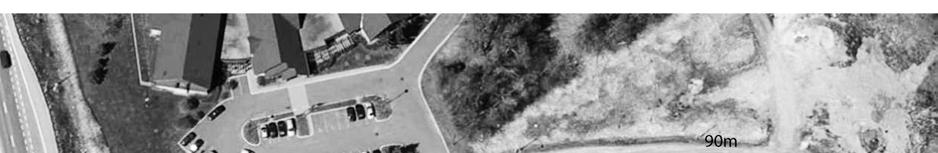


18 16 FIGURE 4.4 RUSSELL ROAD ACCESS SIGHT LINE
19 17 intersection for the impact of site trips during the weekday peak AM and PM hour of the adjacent roads at the year 2016 when the development is expected to be completed. The findings and recommendations of the study are summarized in the following: 1) The trip generation analysis determined that the proposed development would generate 12 new vehicles trips during the peak AM hour and 13 new vehicles trips during the peak PM hour. 2) The Russell Road access would be a full movement access. The analysis determined that the access would operate at an acceptable level of service during the 2016 peak AM and PM hours. The access is located approximately 15 m west of the access to the William E. Hay Centre. There is an existing eastbound left turn lane into the Centre which provides 25 m of vehicular storage. Peak hour traffic counts taken in April 2014 determined that there was a very low volume of trips entering the site, and an analysis for the expected 2016 traffic volumes determined that the eastbound left turn movement would experience a 95 th percentile queue of 0.01 vehicles during peak hours. The expected queue into the William E. Hay Centre would not interfere with the westbound Russell left turn movements entering the site and exiting left turn movements from the site. Although an exclusive westbound Russell left turn lane into the site is not warranted due to the low volume of traffic, it is recommended that a centre lane be provided with shared left turn movements into both the site and William E. Hay Centre (see Figure 4.3). 3) The Russell Road site access would provide a clear throat distance for exiting vehicles and a sight line distance which would meet the requirements of the Transportation Association of Canada (TAC) publication, Geometric Design Guide for Canadian Roads. 4) The intersection of Hawthorne Road and Russell Road was determined to operate at an acceptable level of service for the traffic counts and the expected 2016 traffic volumes which include the 3009 Hawthorne Road site generated trips. There would be no required intersection modifications due to the development of the 3009 Hawthorne Road site. Prepared by: David J. Halpenny, M. Eng., P. Eng.
20 18 APPENDIX TRAFFIC COUNTS OPERATIONAL ANALYSIS WORK SHEETS
21 19 EXHIBIT PEAK AM HOUR TRAFFIC COUNTS Hawthorne/Russell
22 20 EXHIBIT PEAK PM HOUR TRAFFIC COUNTS Hawthorne/Russell
23 21 EXHIBIT 3 YEAR 2016 PEAK AM HOUR TOTAL TRAFFIC ANALYSIS Access/Russell HCS+: Unsignalized Intersections Release 5.6 TWO-WAY STOP CONTROL SUMMARY Analysis Time Period: Peak AM Hour Intersection: Access/Russell Analysis Year: Year 2016 Project ID: 3009 Hawthorne Road East/West Street: Access North/South Street: Russell Road Intersection Orientation: EW Study period (hrs): 0.25 Vehicle Volumes and Adjustments Major Street: Approach Eastbound Westbound Movement L T R L T R Volume Peak-Hour Factor, PHF Hourly Flow Rate, HFR Percent Heavy Vehicles Median Type/Storage Undivided / RT Channelized? Lanes Configuration TR LT Upstream Signal? No No Minor Street: Approach Northbound Southbound Movement L T R L T R Volume 1 0 Peak Hour Factor, PHF Hourly Flow Rate, HFR 1 0 Percent Heavy Vehicles 0 0 Percent Grade (%) 0 0 Flared Approach: Exists?/Storage No / / Lanes 0 0 Configuration LR Delay, Queue Length, and Level of Service Approach EB WB Northbound Southbound Movement Lane Config LT LR v (vph) 1 1 C(m) (vph) v/c % queue length Control Delay LOS A B Approach Delay 10.2 Approach LOS B
24 22 EXHIBIT 4 YEAR 2016 PEAK PM HOUR TOTAL TRAFFIC ANALYSIS Access/Russell HCS+: Unsignalized Intersections Release 5.6 TWO-WAY STOP CONTROL SUMMARY Analysis Time Period: Peak PM Hour Intersection: Access/Russell Analysis Year: Year 2016 Project ID: 3009 Hawthorne Road East/West Street: Access North/South Street: Russell Road Intersection Orientation: EW Study period (hrs): 0.25 Vehicle Volumes and Adjustments Major Street: Approach Eastbound Westbound Movement L T R L T R Volume Peak-Hour Factor, PHF Hourly Flow Rate, HFR Percent Heavy Vehicles Median Type/Storage Undivided / RT Channelized? Lanes Configuration TR LT Upstream Signal? No No Minor Street: Approach Northbound Southbound Movement L T R L T R Volume 10 1 Peak Hour Factor, PHF Hourly Flow Rate, HFR 10 1 Percent Heavy Vehicles 0 0 Percent Grade (%) 0 0 Flared Approach: Exists?/Storage No / / Lanes 0 0 Configuration LR Delay, Queue Length, and Level of Service Approach EB WB Northbound Southbound Movement Lane Config LT LR v (vph) 0 11 C(m) (vph) v/c % queue length Control Delay LOS A A Approach Delay 9.6 Approach LOS A
25 23 EXHIBIT 5 YEAR 2016 PEAK AM HOUR TOTAL TRAFFIC ANALYSIS W. E. Hay/Russell HCS+: Unsignalized Intersections Release 5.6 TWO-WAY STOP CONTROL SUMMARY Analysis Time Period: Peak AM Hour Intersection: William E. Hay/Russell Analysis Year: Year 2016 Project ID: 3009 Hawthorne Road East/West Street: William E. Hay Centre Access North/South Street: Russell Road Intersection Orientation: EW Study period (hrs): 0.25 Vehicle Volumes and Adjustments Major Street: Approach Eastbound Westbound Movement L T R L T R Volume Peak-Hour Factor, PHF Hourly Flow Rate, HFR Percent Heavy Vehicles Median Type/Storage Undivided / RT Channelized? Lanes Configuration L T TR Upstream Signal? No No Minor Street: Approach Northbound Southbound Movement L T R L T R Volume 0 2 Peak Hour Factor, PHF Hourly Flow Rate, HFR 0 2 Percent Heavy Vehicles 0 0 Percent Grade (%) 0 0 Flared Approach: Exists?/Storage / No / Lanes 0 0 Configuration LR Delay, Queue Length, and Level of Service Approach EB WB Northbound Southbound Movement Lane Config L LR v (vph) 5 2 C(m) (vph) v/c % queue length Control Delay LOS A A Approach Delay 9.5 Approach LOS A
26 24 EXHIBIT 6 YEAR 2016 PEAK PM HOUR TOTAL TRAFFIC ANALYSIS W. E. Hay/Russell HCS+: Unsignalized Intersections Release 5.6 TWO-WAY STOP CONTROL SUMMARY Analysis Time Period: Peak PM Hour Intersection: William E. Hay/Russell Analysis Year: Year 2016 Project ID: 3009 Hawthorne Road East/West Street: William E. Hay Centre Access North/South Street: Russell Road Intersection Orientation: EW Study period (hrs): 0.25 Vehicle Volumes and Adjustments Major Street: Approach Eastbound Westbound Movement L T R L T R Volume Peak-Hour Factor, PHF Hourly Flow Rate, HFR Percent Heavy Vehicles Median Type/Storage Undivided / RT Channelized? Lanes Configuration L T TR Upstream Signal? No No Minor Street: Approach Northbound Southbound Movement L T R L T R Volume 2 10 Peak Hour Factor, PHF Hourly Flow Rate, HFR 2 10 Percent Heavy Vehicles 0 0 Percent Grade (%) 0 0 Flared Approach: Exists?/Storage / No / Lanes 0 0 Configuration LR Delay, Queue Length, and Level of Service Approach EB WB Northbound Southbound Movement Lane Config L LR v (vph) 4 12 C(m) (vph) v/c % queue length Control Delay LOS A A Approach Delay 8.8 Approach LOS A
27 25 EXHIBIT 7 YEAR 2015 PEAK AM HOUR TOTAL TRAFFIC ANALYSIS Hawthorne/Russell HCS+: Signalized Intersections Release 5.4 Analyst: Inter.: Hawthorne/Russell Period: Peak AM Hour Year: Year 2015 Project ID: 3009 Hawthorne Road E/W St: Russell Road East N/S St: Hawthorne Road South SIGNALIZED INTERSECTION SUMMARY Eastbound Westbound Northbound Southbound L T R L T R L T R L T R No. Lanes LGConfig L TR L T L TR L TR Volume Lane Width RTOR Vol _ Duration 0.25 Area Type: All other areas Signal Operations Phase Combination EB Left A NB Left P Thru A Thru P A P Peds X Peds X WB Left A SB Left P Thru A Thru P P Peds X Peds X NB EB SB WB Green Yellow All Red Cycle Length: 90.0 secs CAPACITY AND LOS WORKSHEET Capacity Analysis and Lane Group Capacity Adj Adj Sat Flow Green --Lane Group-- Appr/ Lane Flow Rate Flow Rate Ratio Ratio Capacity v/c Mvmt Group (v) (s) (v/s) (g/c) (c) Ratio _ Eastbound Left L # Thru TR Westbound Left L Thru T Northbound Left L Thru TR # Southbound Left L Thru TR _ Sum of flow ratios for critical lane groups, Yc = Sum (v/s) = 0.32 Total lost time per cycle, L = sec Critical flow rate to capacity ratio, Xc = (Yc)(C)/(C-L) = 0.36
28 26 EXHIBIT 8 YEAR 2015 PEAK PM HOUR TOTAL TRAFFIC ANALYSIS Hawthorne/Russell HCS+: Signalized Intersections Release 5.4 Analyst: Inter.: Hawthorne/Russell Period: Peak PM Hour Year: Year 2015 Project ID: 3009 Hawthorne Road E/W St: Russell Road East N/S St: Hawthorne Road South SIGNALIZED INTERSECTION SUMMARY Eastbound Westbound Northbound Southbound L T R L T R L T R L T R No. Lanes LGConfig L TR L T L TR L TR Volume Lane Width RTOR Vol _ Duration 0.25 Area Type: All other areas Signal Operations Phase Combination EB Left A NB Left P Thru A Thru P A P Peds X Peds X WB Left A SB Left P Thru A Thru P P Peds X Peds X NB EB SB WB Green Yellow All Red Cycle Length: 85.0 secs CAPACITY AND LOS WORKSHEET Capacity Analysis and Lane Group Capacity Adj Adj Sat Flow Green --Lane Group-- Appr/ Lane Flow Rate Flow Rate Ratio Ratio Capacity v/c Mvmt Group (v) (s) (v/s) (g/c) (c) Ratio _ Eastbound Left L # Thru TR Westbound Left L Thru T Northbound Left L Thru TR Southbound Left L Thru TR # _ Sum of flow ratios for critical lane groups, Yc = Sum (v/s) = 0.41 Total lost time per cycle, L = sec Critical flow rate to capacity ratio, Xc = (Yc)(C)/(C-L) = 0.46
29 27 EXHIBIT 9 YEAR 2016 PEAK AM HOUR TOTAL TRAFFIC ANALYSIS Hawthorne/Russell HCS+: Signalized Intersections Release 5.4 Analyst: Inter.: Hawthorne/Russell Period: Peak AM Hour Year: Year 2016 Project ID: 3009 Hawthorne Road E/W St: Russell Road East N/S St: Hawthorne Road South SIGNALIZED INTERSECTION SUMMARY Eastbound Westbound Northbound Southbound L T R L T R L T R L T R No. Lanes LGConfig L TR L T L TR L TR Volume Lane Width RTOR Vol _ Duration 0.25 Area Type: All other areas Signal Operations Phase Combination EB Left A NB Left P Thru A Thru P A P Peds X Peds X WB Left A SB Left P Thru A Thru P P Peds X Peds X NB EB SB WB Green Yellow All Red Cycle Length: 90.0 secs CAPACITY AND LOS WORKSHEET Capacity Analysis and Lane Group Capacity Adj Adj Sat Flow Green --Lane Group-- Appr/ Lane Flow Rate Flow Rate Ratio Ratio Capacity v/c Mvmt Group (v) (s) (v/s) (g/c) (c) Ratio _ Eastbound Left L Thru TR Westbound Left L # Thru T Northbound Left L Thru TR # Southbound Left L Thru TR _ Sum of flow ratios for critical lane groups, Yc = Sum (v/s) = 0.37 Total lost time per cycle, L = sec Critical flow rate to capacity ratio, Xc = (Yc)(C)/(C-L) = 0.42
30 28 EXHIBIT 10 YEAR 2016 PEAK PM HOUR TOTAL TRAFFIC ANALYSIS Hawthorne/Russell HCS+: Signalized Intersections Release 5.4 Analyst: Inter.: Hawthorne/Russell Period: Peak PM Hour Year: Year 2016 Project ID: 3009 Hawthorne Road E/W St: Russell Road East N/S St: Hawthorne Road South SIGNALIZED INTERSECTION SUMMARY Eastbound Westbound Northbound Southbound L T R L T R L T R L T R No. Lanes LGConfig L TR L T L TR L TR Volume Lane Width RTOR Vol _ Duration 0.25 Area Type: All other areas Signal Operations Phase Combination EB Left A NB Left P Thru A Thru P A P Peds X Peds X WB Left A SB Left P Thru A Thru P P Peds X Peds X NB EB SB WB Green Yellow All Red Cycle Length: 85.0 secs CAPACITY AND LOS WORKSHEET Capacity Analysis and Lane Group Capacity Adj Adj Sat Flow Green --Lane Group-- Appr/ Lane Flow Rate Flow Rate Ratio Ratio Capacity v/c Mvmt Group (v) (s) (v/s) (g/c) (c) Ratio _ Eastbound Left L # Thru TR Westbound Left L Thru T Northbound Left L Thru TR Southbound Left L Thru TR # _ Sum of flow ratios for critical lane groups, Yc = Sum (v/s) = 0.41 Total lost time per cycle, L = sec Critical flow rate to capacity ratio, Xc = (Yc)(C)/(C-L) = 0.47
OFFICE/RETAIL DEVELOPMENT 1625 BANK STREET OTTAWA, ONTARIO TRANSPORTATION BRIEF. Prepared for: Canada Inc.
 OFFICE/RETAIL DEVELOPMENT 1625 BANK STREET OTTAWA, ONTARIO TRANSPORTATION BRIEF Prepared for: 9402209 Canada Inc. December 15, 2015 115-625 Report_2.doc D. J. Halpenny & Associates Ltd. Consulting Transportation
INDUSTRIAL BUILDING 1660 COMSTOCK ROAD CITY OF OTTAWA TRANSPORTATION OVERVIEW. Prepared for:
 INDUSTRIAL BUILDING 1660 COMSTOCK ROAD CITY OF OTTAWA TRANSPORTATION OVERVIEW Prepared for: Simluc Contractors Limited 2550 Blackwell Street, Ottawa K1B 5R1 October 18, 2013 113-584 Overview_1.doc D. J.
FAIRFIELD INN & SUITES HOTEL 135 THAD JOHNSON PRIVATE OTTAWA TRANSPORTATION BRIEF. Prepared for:
 FAIRFIELD INN & SUITES HOTEL 135 THAD JOHNSON PRIVATE OTTAWA TRANSPORTATION BRIEF Prepared for: Bona Building & Management Co. Ltd. Place Vanier, 333 North River Road Vanier, Ontario K1L 8B9 August 12,
HOLIDAY INN HOTEL 235 KING EDWARD AVENUE CITY OF OTTAWA TRANSPORTATION BRIEF. Prepared for:
 HOLIDAY INN HOTEL 235 KING EDWARD AVENUE CITY OF OTTAWA TRANSPORTATION BRIEF Prepared for: Momentum Planning & Communications 1165 Greenlawn Crescent Ottawa, ON K1L 6C2 June 29, 2015 115-618 Brief_1.doc
URBAN QUARRY HEADQUARTERS 2717 STEVENAGE DRIVE CITY OF OTTAWA TRANSPORTATION OVERVIEW. Prepared for: Urban Quarry 4123 Belgreen Drive, Ottawa K1G 3N2
 URBAN QUARRY HEADQUARTERS 2717 STEVENAGE DRIVE CITY OF OTTAWA TRANSPORTATION OVERVIEW Prepared for: Urban Quarry 4123 Belgreen Drive, Ottawa K1G 3N2 February 27, 2014 113-584 Overview_1.doc D. J. Halpenny
HILTON GARDEN INN HOTEL HOTEL EXPANSION 2400 ALERT ROAD, OTTAWA TRANSPORTATION BRIEF. Prepared for:
 HILTON GARDEN INN HOTEL HOTEL EXPANSION 2400 ALERT ROAD, OTTAWA TRANSPORTATION BRIEF Prepared for: Bona Building & Management Co. Ltd. Place Vanier, 333 North River Road Vanier, Ontario K1L 8B9 October
APARTMENT BUILDING DEVELOPMENT 1161 HERON ROAD OTTAWA, ONTARIO TRANSPORTATION IMPACT STUDY. Prepared for:
 APARTMENT BUILDING DEVELOPMENT 1161 HERON ROAD OTTAWA, ONTARIO TRANSPORTATION IMPACT STUDY Prepared for: 1649362 Ontario Inc. c/o Manor Park Management 231 Brittany Drive, Suite D Ottawa ON K1K 0R8 July
MEETING FACILITY 2901 GIBFORD DRIVE CITY OF OTTAWA TRANSPORTATION BRIEF. Prepared for: Holiday Inn Express 2881 Gibford Drive Ottawa, ON K1V 2L9
 MEETING FACILITY 2901 GIBFORD DRIVE CITY OF OTTAWA TRANSPORTATION BRIEF Prepared for: Holiday Inn Express 2881 Gibford Drive Ottawa, ON K1V 2L9 December 18, 2012 112-566 Brief_1.doc D. J. Halpenny & Associates
MEDICAL/OFFICE BUILDING 1637 BANK STREET OTTAWA, ONTARIO TRANSPORTATION OVERVIEW. Prepared for:
 MEDICAL/OFFICE BUILDING 1637 BANK STREET OTTAWA, ONTARIO TRANSPORTATION OVERVIEW Prepared for: 2434984 Ontario Inc. 13-5510 Canotek Road Ottawa, Ontario K1J 9J5 June 4, 2015 115-613 Report_2.doc D. J.
OTTAWA TRAIN YARDS PHASE 3 DEVELOPMENT CITY OF OTTAWA TRANSPORTATION IMPACT STUDY. Prepared for:
 OTTAWA TRAIN YARDS PHASE 3 DEVELOPMENT CITY OF OTTAWA TRANSPORTATION IMPACT STUDY Prepared for: The Ottawa Train Yards Inc. 223 Colonnade Road South, Suite 212 Nepean, Ontario K2E 7K3 January 17, 2012
QUICKIE C STORE AND GAS BAR 1780 HERON ROAD OTTAWA, ONTARIO TRANSPORTATION BRIEF. Prepared for:
 QUICKIE C STORE AND GAS BAR 1780 HERON ROAD OTTAWA, ONTARIO TRANSPORTATION BRIEF Prepared for: Quickie Convenience Stores Larny Holdings Ltd. c/o PBC Group April 15, 2015 115-615 Report_1.doc D. J. Halpenny
ORLEANS GARDENS SHOPPING CENTRE 1615 ORLEANS BOULEVARD CITY OF OTTAWA, ONTARIO TRANSPORTATION IMPACT STUDY. Prepared for:
 ORLEANS GARDENS SHOPPING CENTRE 1615 ORLEANS BOULEVARD CITY OF OTTAWA, ONTARIO TRANSPORTATION IMPACT STUDY Prepared for: Orleans Gardens Shopping Centre Inc. 2851 John Street, Suite 1 Markham, ON K3R 5R7
COMMERCIAL DEVELOPMENT 2015 ROBERTSON ROAD OTTAWA, ONTARIO TRANSPORTATION BRIEF. Prepared for:
 COMMERCIAL DEVELOPMENT 2015 ROBERTSON ROAD OTTAWA, ONTARIO TRANSPORTATION BRIEF Prepared for: First Bay Properties Inc. 311 Richmond Road, Suite 203 Ottawa, ON K1Z 6X3 August 8, 2017 117-663 Brief_1.doc
HENDERSON DEVELOPMENT 213, 217, 221, 221 ½, 223 HENDERSON AVENUE and 65 TEMPLETON STREET OTTAWA, ONTARIO TRANSPORTATION OVERVIEW.
 HENDERSON DEVELOPMENT 213, 217, 221, 221 ½, 223 HENDERSON AVENUE and 65 TEMPLETON STREET OTTAWA, ONTARIO TRANSPORTATION OVERVIEW Prepared for: 2294170 Ontario Inc. February 2, 2017 117-652 Report_1.doc
NEW YORK CENTRAL PARK SUBDIVISION BLAIS STREET/ST-PIERRE STREET EMBRUN, ONTARIO TRAFFIC IMPACT STUDY. Prepared for:
 NEW YORK CENTRAL PARK SUBDIVISION BLAIS STREET/ST-PIERRE STREET EMBRUN, ONTARIO TRAFFIC IMPACT STUDY Prepared for: Solidex Holdings Limited & Investissement Maurice Lemieux Investments Attn: Mr. Anthony
BLUE SEA VILLAGE MER BLEUE 2159 MER BLEUE ROAD OTTAWA, ONTARIO TRANSPORTATION IMPACT ASSESSMENT. Prepared for: Ontario Limited.
 BLUE SEA VILLAGE MER BLEUE 2159 MER BLEUE ROAD OTTAWA, ONTARIO TRANSPORTATION IMPACT ASSESSMENT Prepared for: 2534189 Ontario Limited April 6, 2018 117-668 TIA Report_2.doc D. J. Halpenny & Associates
The proposed development is located within 800m of an existing Transit Station where infill developments and intensification are encouraged.
 Stantec Consulting Ltd. 1331 Clyde Avenue, Suite 4 Ottawa ON K2C 3G4 Tel: (613) 722-442 Fax: (613) 722-2799 May 14, 213 File: 1638823 Robinson Park Development Corp. 5699 Power Road Ottawa, ON, K1G 3N4
REDEVELOPMENT TRAFFIC IMPACT STUDY
 REDEVELOPMENT TRAFFIC IMPACT STUDY For Wendy s Parker, Colorado January 215 Prepared for: Sterling Design Associates, LLC 29 W. Littleton Boulevard #3 Littleton, Colorado 812 Prepared by: 1233 Airport
Traffic Impact Study. Roderick Place Columbia Pike Thompson s Station, TN. Transportation Group, LLC Traffic Engineering and Planning
 F i s c h b a c h Transportation Group, LLC Traffic Engineering and Planning Traffic Impact Study Roderick Place Columbia Pike Thompson s Station, TN Prepared March 2016 Ms. Gillian L. Fischbach, P.E.,
Traffic Impact Analysis Chatham County Grocery Chatham County, NC
 Chatham County Grocery Chatham County, NC TABLE OF CONTENTS 1. INTRODUCTION... 1 1.1. Location and Study Area... 1 1.2. Proposed Land Use and Access... 2 1.3. Adjacent Land Uses... 2 1.4. Existing ways...
9 Leeming Drive Redevelopment Ottawa, ON Transportation Brief. Prepared By: Stantec Consulting Ltd.
 9 Leeming Drive Redevelopment Ottawa, ON Transportation Brief Prepared By: Stantec Consulting Ltd. TIA GUIDELINES CHECKLIST Report Context Municipal Address Comment: Section 1.1 Location relative to major
Glenn Avenue Corridor Traffic Operational Evaluation
 Glenn Avenue Corridor Traffic Operational Evaluation PREPARED FOR: THE CITY OF AUBURN PREPARED BY: DECEMBER 2007 Glenn Avenue Corridor Study--Auburn, Alabama TABLE OF CONTENTS Introduction... 1 Background
Draft Report. Traffic Impact Study. Superstore, Wal-Mart, and Kent Development. Yarmouth, Nova Scotia. Prepared for
 oad & Traffic Management Road & Traffic Management R Atlantic Traffic Engineering Specialists Draft Report Traffic Impact Study Superstore, Wal-Mart, and Kent Development Yarmouth, Nova Scotia Prepared
TRAFFIC IMPACT STUDY
 675 Millcreek Drive, Unit 1 Mississauga, Ontario L5N 5M4 T: 416.213.7121 F: 95.89.8499 www.transtech.co TRAFFIC IMPACT STUDY PROPOSED MOSQUE DEVELOPMENT 4269 REGIONAL ROAD 25 TOWN OF OAKVILLE PREPARED
Signal Warrant Studies
 Signal Warrant Studies Seven Locations Piqua, Ohio December 12, 217 Signal Warrant Studies Seven Locations Piqua, Ohio TABLE OF CONTENTS Executive Summary... 3 Introduction... 5 Study Location... 5 Data
James M. Moore, Director of Planning & Building Services, Town of Fairfax. Victory Village Senior Housing Development Traffic Study
 Traffic Study To: From: James M. Moore, Director of Planning & Building Services, Town of Fairfax David Parisi, PE, TE, Parisi Transportation Consulting Date: October 14, 216 Subject: Victory Village Senior
Bistro 6. City of Barrie. Traffic Impact Study for Pratt Hansen Group Inc. Type of Document: Final Report. Project Number: JDE 1748
 City of Barrie Traffic Impact Study for Pratt Hansen Group Inc. Type of Document: Final Report Project Number: JDE 1748 Date Submitted: June 12 th, 2017 06/12/17 John Northcote, P.Eng. Professional License
EXECUTIVE SUMMARY. Page 1 of 6
 EXECUTIVE SUMMARY The purpose of this report is to identify conformance with the original traffic impact study for the proposed retail development on Lot 5 of Riverdale Retail Filing No. 1 located on the
Traffic Impact Analysis Walton Acres at Riverwood Athletic Club Clayton, NC
 Traffic Impact Analysis Walton Acres at Riverwood Athletic Club Clayton, NC 1. TABLE OF CONTENTS INTRODUCTION...1 1.1. Site Location and Study Area...1 1.2. Proposed Land Use and Site Access...2 1.3.
TRAFFIC IMPACT STUDY And A TRAFFIC SIGNAL WARRANT ANALYSIS FOR A SENIOR LIVING AND APARTMENT DEVELOPMENT
 TRAFFIC IMPACT STUDY And A TRAFFIC SIGNAL WARRANT ANALYSIS FOR A SENIOR LIVING AND APARTMENT DEVELOPMENT DEERFIELD TOWNSHIP, WARREN COUNTY, OHIO Nantucket Circle and Montgomery Road () Prepared for: ODLE
5858 N COLLEGE, LLC N College Avenue Traffic Impact Study
 5858 N COLLEGE, LLC nue Traffic Impact Study August 22, 2016 Contents Traffic Impact Study Page Preparer Qualifications... 1 Introduction... 2 Existing Roadway Conditions... 5 Existing Traffic Conditions...
Troutbeck Farm Development
 Troutbeck Farm Development Willistown Township, Chester County PA For Submission To: Willistown Township Last Revised: October, 4 TPD# INLM.A. 5 E. High Street Suite 65 Pottstown, PA 9464 6.36.3 TPD@TrafficPD.com
Traffic Impact Study WestBranch Residential Development Davidson, NC March 2016
 Traffic Impact Study WestBranch Residential Development Davidson, NC March 216 TRAFFIC IMPACT STUDY FOR THE WestBranch Residential Development LOCATED IN DAVIDSON, NC Prepared For: Lennar Carolinas, LLC
VIVA RETIREMENT COMMUNITIES OAKVILLE TRAFFIC IMPACT STUDY
 VIVA RETIREMENT COMMUNITIES OAKVILLE TRAFFIC IMPACT STUDY VIVA RETIREMENT COMMUNITIES OAKVILLE TRAFFIC IMPACT STUDY DECEMBER 2012 READ, VOORHEES & ASSOCIATES TORONTO, ONTARIO Read, Voorhees & Associates
Donahue Drive Corridor Traffic Operational Evaluation
 Donahue Drive Corridor Traffic Operational Evaluation PREPARED FOR: THE CITY OF AUBURN PREPARED BY: JANUARY 2007 Donahue Drive Corridor Study--Auburn, Alabama TABLE OF CONTENTS Introduction... 1 Background
1609 E. FRANKLIN STREET HOTEL TRAFFIC IMPACT STUDY EXECUTIVE SUMMARY
 1609 E. FRANKLIN STREET HOTEL TRAFFIC IMPACT STUDY EXECUTIVE SUMMARY Prepared for: The Town of Chapel Hill Public Works Department Traffic Engineering Division Prepared by: HNTB North Carolina, PC 343
Harrah s Station Square Casino
 Transportation Analysis Harrah s Station Square Casino Pittsburgh, Pennsylvania Submitted To: City of Pittsburgh and Pennsylvania Gaming Control Board Prepared By: DKS Associates GAI Consultants December
Henderson Avenue Mixed-Use Development
 Zoning Case: Z145-3 Traffic Impact Analysis Henderson Avenue Mixed-Use Development Dallas, TX October 26 th, 216 Kimley-Horn and Associates, Inc. Dallas, Texas Project #644827 Registered Firm F-928 Traffic
Place Vanier 250 Montreal Road Transportation Impact Study Addendum. Prepared for Broccolini Construction September 20 th, 2012
 Update for the May 31 st, 2012 Traffic Impact Study Prepared for Broccolini Construction 111-23596-00 September 20 th, 2012 2611 Queensview Drive, Suite 300, Ottawa, Ontario CANADA K2B 8K2 Telephone: 613-829-2800
APPENDIX C Additional Traffic Data
 APPENDIX C Additional Traffic Data Raleigh and Heiden Properties FEIS F- ATTACHMENT Response.8- Traffic Count WEEKENDPEAK5MINUTECOUNTSPROJECTRaleighandHeidenPropertiesLOCATIONCR6,andCR9DATEFridayAugust6,TIME:PMto6:PM5MinuteTraficCR6SBCR9EBCR6NBSTARTENDleftthrurightTotalleftthrurightTotalleftthrurightTotalleftthrurightTotalGRANDTIMETIME56TAL-------------------:PM:5PM56:5PM:PM666566:PM:5PM685886:5PM:PM555585:PM:5PM5856889:5PM:PM8656:PM:5PM955656885:5PM:PM65986858:PM:5PM66855:5PM:PM69898:PM:5PM895858959:5PM:PM8589:PM:5PM85569:5PM:PM586985:PM:5PM55859565:5PM5:PM886559655:PM5:5PM56699595:5PM5:PM668955:PM5:5PM666856555:5PM6:PM95885-------------------TAL85896959688668
THE LANDMARK AT TALBOT PARK
 TRAFFIC IMPACT STUDY FOR THE LANDMARK AT TALBOT PARK IN NORFOLK, VA INTERMODAL ENGINEERING, P.C. OCTOBER, 200 The Landmark at Talbot Park is a proposed redevelopment of the existing apartments along the
List of Attachments. Location Map... Site Plan... City of Lake Elsinore Circulation Element... City of Lake Elsinore Roadway Cross-Sections...
 List of Attachments Exhibits Location Map... Site Plan... City of Lake Elsinore Circulation Element... City of Lake Elsinore Roadway Cross-Sections... Existing Lane Geometry and Traffic Controls... Existing
Traffic Impact Study. Crestline Piggly Wiggly Mountain Brook, Alabama. Goodwyn, Mills and Cawood, Inc. Birmingham, Alabama.
 Traffic Impact Study Crestline Piggly Wiggly Mountain Brook, Alabama Prepared for: Goodwyn, Mills and Cawood, Inc. Birmingham, Alabama September 214 Revision 1 October 214 Crestline Piggly Wiggly Mountain
CastleGlenn Consultants Inc.
 February 1 st, 2010 CastleGlenn Consultants Inc. Engineers, Project Managers & Planners Mr. Kevin Yemm Planning and Land Development Richraft Ltd. 2280 St. Laurent Boulevard Suite 201 Ottawa, Ontario (Tel:
CPC Parking Lot Riverside Drive. Transportation Brief
 CPC Parking Lot 2785 Riverside Drive Transportation Brief Prepared By: NOVATECH Suite 2, 24 Michael Cowpland Drive Ottawa, Ontario K2M P6 7 / 5 / 25 Novatech File: 49 Ref: R-25-22 July 5 th, 25 City of
Route 28 (South Orleans Road)/Route 39 (Harwich Road)/Quanset Road Intersection
/Route 39 (Harwich Road)/Quanset Road Intersection") TRAFFIC FEASIBILITY STUDY Route 28 (South Orleans Road)/Route 39 (Harwich Road)/Quanset Road Intersection Orleans, Massachusetts Prepared for: Town of Orleans Prepared by: Fay, Spofford & Thorndike, LLC
TRAFFIC FEASIBILITY STUDY Route 28 (South Orleans Road)/Route 39 (Harwich Road)/Quanset Road Intersection Orleans, Massachusetts Prepared for: Town of Orleans Prepared by: Fay, Spofford & Thorndike, LLC
HUMC/Mountainside Hospital Redevelopment Plan
 Traffic and Parking Analysis HUMC/Mountainside Hospital Redevelopment Plan in Glen Ridge Borough and Montclair Township PREPARED FOR H2M 119 Cherry Hill Road, Suite 11 Parsippany, NJ 754 862.27.59 PREPARED
APPENDIX D Traffic Impact Study (Draft Report)
") ENVIRONMENTAL IMPACT ASSESSMENT (EIA) REGISTRATION, TRAFFIC IMPACT STUDY (DRAFT REPORT), AND WATER SUPPLY SOURCE ASSESSMENT (WSSA): CAMPING PLAGE ABOITEAU BEACH, CAP-PELÉ, NB APPENDIX D (Draft Report)
ENVIRONMENTAL IMPACT ASSESSMENT (EIA) REGISTRATION, TRAFFIC IMPACT STUDY (DRAFT REPORT), AND WATER SUPPLY SOURCE ASSESSMENT (WSSA): CAMPING PLAGE ABOITEAU BEACH, CAP-PELÉ, NB APPENDIX D (Draft Report)
Capital Region Council of Governments
 March 23, 2018 Capital Region Council of Governments PROJECT CONCEPT REPORT Realignment of Swamp and Northfield Road s approaches to Route 44 (Boston Turnpike) Town of Coventry SUMMARY: The Town of Coventry
Transportation Impact Study for Abington Terrace
 Transportation Impact Study for Abington Terrace Abington Township, Montgomery County, PA Sandy A. Koza, P.E., PTOE PA PE License Number PE059911 Prepared by McMahon Associates, Inc. 425 Commerce Drive,
Table of Contents FIGURES TABLES APPENDICES. Traffic Impact Study Hudson Street Parking Garage MC Project No.: A Table of Contents
 Traffic Impact Study Hudson Street Parking Garage MC Project No.: 151714A Table of Contents Table of Contents I. INTRODUCTION... 2 II. EXISTING CONDITIONS... 5 III. 215 EXISTING TRAFFIC CONDITIONS... 6
Student Housing Development
 Traffic Impact Study for the proposed Student Housing Development City of Oneonta Otsego County, New York Project No. 3259 December 212 Revised February 13, 212 Prepared For: Newman Development Group,
Traffic Impact Study Little Egypt Road Development Denver, North Carolina June 2017
 Traffic Impact Study Little Egypt Road Development Denver, North arolina June 2017 N. Little Egypt Road DQ\ QDQFLQJ VDOHV RU RWKHU SHUIRUPDQFH EDVHG FULWHULD Proposed Site Driveways Site Driveway 1 TRAFFI
DUNBOW ROAD FUNCTIONAL PLANNING
 DUNBOW ROAD FUNCTIONAL PLANNING Final Report August 3, 216 #31, 316 5th Avenue NE Calgary, AB T2A 6K4 Phone: 43.273.91 Fax: 43.273.344 wattconsultinggroup.com Dunbow Road Functional Planning Final Report
TRANSPORTATION ANALYSIS REPORT US Route 6 Huron, Erie County, Ohio
 TRANSPORTATION ANALYSIS REPORT US Route 6 Huron, Erie County, Ohio December 12, 2012 Prepared for: The City of Huron 417 Main Huron, OH 44839 Providing Practical Experience Technical Excellence and Client
TRAFFIC SIGNAL WARRANT STUDY
 TRAFFIC SIGNAL WARRANT STUDY 5 th STREET & ENCHANTED PINES DRIVE JANUARY 2013 TRAFFIC OPERATIONS ENGINEERING SERVICES/PUBLIC WORKS DEPARTMENT TABLE OF CONTENTS INTERSECTION LOCATION MAP ii INTRODUCTION
PINESTONE TRAFFIC IMPACT STUDY Travelers Rest, South Carolina
 PINESTONE TRAFFIC IMPACT STUDY Travelers Rest, South Carolina Prepared for Longbranch Development Prepared by January 13, 219 ii Table of Contents Subject Page Signature Page... i Table of Contents...
Existing Conditions. Date: April 16 th, Dan Holderness; Coralville City Engineer Scott Larson; Coralville Assistant City Engineer
 Date: April 16 th, 2015 To: From: Re: Dan Holderness; Coralville City Engineer Scott Larson; Coralville Assistant City Engineer Darian Nagle-Gamm, Traffic Engineering Planner Highway 6 (2 nd Street) /
TABLE OF CONTENTS TABLE OF CONTENTS... I APPENDICES... III LIST OF EXHIBITS... V LIST OF TABLES... VII LIST OF ABBREVIATED TERMS...
 TABLE OF CONTENTS TABLE OF CONTENTS... I APPENDICES... III LIST OF EXHIBITS... V LIST OF TABLES... VII LIST OF ABBREVIATED TERMS... IX 1 INTRODUCTION... 1 1.1 Project Overview... 1 1.2 Analysis Scenarios...
List of Exhibits...ii
 One Brickell Traffic Study TABLE OF CONTENTS List of Exhibits...ii EXECUTIVE SUMMARY...1 1. INTRODUCTION...2 1.1 Study Area...2 1.2 Study Objective...5 2. EXISTING TRAFFIC CONDITIONS...6 2.1 Data Collection...6
Traffic Impact Study, Premier Gold Mines Limited, Hardrock Property
 Traffic Impact Study, Premier Gold Mines Limited, Hardrock Property Prepared for: Premier Gold Mines Limited Prepared by: Stantec Consulting Ltd. November 2014
2136 And 2148 Trafalgar Road Townhouse Development Traffic Brief. Paradigm Transportation Solutions Limited
 2136 And 2148 Trafalgar Road Townhouse Development Traffic Brief Paradigm Transportation Solutions Limited March 217 March 217 Project: 1627 Diana Vlasic, M.C.I.P., R.P.P Metropolitan Consulting 445 Paletta
Road Conversion Study Plumas Street
 Plumas Street Phase I Submitted to The Regional Transportation Commission of Washoe County Submitted by Zong Tian, Ph.D., P.E. Saeedeh Farivar Haiyuan Li, Ph.D. Center for Advanced Transportation Education
Michigan Avenue Traffic Study
 City of Sarnia Michigan Avenue Traffic Study Final Report November 29, 218 B17 SUBMITTED BY CIMA CANADA INC. 4 327 Harvester Road Burlington, ON L7N 3G7 T 289 288-287 F 289 288-285 cima.ca CONTACT Stephen
MEMO DRAFT VIA . Mr. Terry Bailey Foremost Development Company. To: Michael J. Labadie, PE Steven J. Russo, E.I.T. Fleis & VandenBrink.
 MEMO DRAFT VIA EMAIL To: From: Mr. Terry Bailey Foremost Development Company Michael J. Labadie, PE Steven J. Russo, E.I.T. Fleis & VandenBrink Date: August 29, 214 Re: Proposed Apartments City of Walled
2. Existing Conditions
 2. Existing Conditions The existing traffic and parking conditions on the site and the surrounding area were reviewed based on the study methodology in Section 1.2. 2.1 Existing Land Use The portion of
MEMORANDUM. DATE March 1, 2012 TO Town of Milton Mark Abbott, Seth Asante, and Efi Pagitsas Boston Region MPO Staff
 MEMORANDUM DATE March 1, 212 TO Town of Milton FROM RE Mark Abbott, Seth Asante, and Efi Pagitsas Boston Region MPO Staff FFY 211 Safety and Operations Analyses at Selected Boston Region MPO Intersections:
joint access drive. will be
 Date: To: From: Subject: June 22, 2015 Bradley Reiner, PE Bowman Consulting David R. Kline, PE, PTOE, Incline Associates Thornton Self-Storage Traffic Analysis (DRAFT) - Thornton, Colorado INTRODUCTION
Gateway Transportation Study
 Gateway Transportation Study Amherst, Massachusetts SUBMITTED TO University of Massachusetts Amherst Town of Amherst SUBMITTED BY Vanasse Hangen Brustlin, Inc. Watertown, Massachusetts March 213 Back of
Traffic Impact Study. Westlake Elementary School Westlake, Ohio. TMS Engineers, Inc. June 5, 2017
 TMS Engineers, Inc. Traffic Impact Study Westlake Elementary School Westlake, Ohio June 5, 2017 Prepared for: Westlake City Schools - Board of Education 27200 Hilliard Boulevard Westlake, OH 44145 TRAFFIC
George Street Transportation Impact Study. Paradigm Transportation Solutions Limited
 George Transportation Impact Study Paradigm Transportation Solutions Limited January 217 Project Summary Project Number 16191 January 217 Client Wastell Homes 5-1895 Blue Heron Drive London ON N6H 5L9
Date: September 7, Project #: Re: Spaulding Youth Center Northfield, NH Property. Traffic Impact Study
 To: Ms. Susan C. Ryan Spaulding Youth Center 72 Spaulding Road Northfield, NH 03276 Date: September 7, 2017 Project #: 52455.00 From: Robin Bousa Director of Transportation Systems Re: Spaulding Youth
Proposed Addition to Pickering Islamic Centre
 TRAFFIC IMPACT STUDY, PARKING STUDY, SITE CIRCULATION REVIEW & TDM PLAN Proposed Addition to Pickering Islamic Centre 265 Brock Road City of Pickering, Ontario Prepared for: Pickering Islamic Centre Masjid
Evaluation of M-99 (Broad Street) Road Diet and Intersection Operational Investigation
 Road Diet and Intersection Operational Investigation") Evaluation of M-99 (Broad Street) Road Diet and Intersection Operational Investigation City of Hillsdale, Hillsdale County, Michigan June 16, 2016 Final Report Prepared for City of Hillsdale 97 North Broad
Evaluation of M-99 (Broad Street) Road Diet and Intersection Operational Investigation City of Hillsdale, Hillsdale County, Michigan June 16, 2016 Final Report Prepared for City of Hillsdale 97 North Broad
Traffic Impact and Access Study PROPOSED DURKEE FARM ESTATES. Foster Street Littleton, Massachusetts. Prepared for: Grimes Road, LLC.
 Traffic Impact and Access Study PROPOSED DURKEE FARM ESTATES Foster Street Littleton, Massachusetts Prepared for: Grimes Road, LLC. Westford, MA Prepared by: MDM Transportation Consultants, Inc. 28 Lord
CITY OF OTTAWA ROADWAY MODIFICATION APPROVAL UNDER DELEGATED AUTHORITY
 RMA-2015-ATM-038 CITY OF OTTAWA ROADWAY MODIFICATION APPROVAL UNDER DELEGATED AUTHORITY DATE: April 22, 2015 SUBJECT Approval of Roadway Modifications Recommended through an Area Traffic Management Study
Magnolia Place. Traffic Impact Analysis. Prepared for: City of San Mateo. Prepared by: Hexagon Transportation Consultants, Inc.
 Magnolia Place Traffic Impact Analysis Prepared for: City of San Mateo Prepared by: Hexagon Transportation Consultants, Inc. Updated January 4, 2010 Table of Contents 1. Introduction...1 2. Existing Conditions...6
TRAFFIC ASSESSMENT River Edge Colorado
 TRAFFIC ASSESSMENT River Edge Colorado Submitted by: Fehr & Peers 621 17th Street, Ste. 231 Denver, CO 8293 (33) 296-43 December, 21 App. M-2 Traffic Assessment River Edge Colorado December 21 TABLE OF
Parking Lot P6C Transportation Impact Assessment
 Transportation Carleton University Parking Lot P6C Transportation Impact Assessment Prepared by: AECOM 302 1150 Morrison Drive 613 820 8282 tel Ottawa, ON, Canada K2H 8S9 613 820 8338 fax www.aecom.com
Chapter 4 Traffic Analysis
 Chapter 4 Traffic Analysis PURPOSE The traffic analysis component of the K-68 Corridor Management Plan incorporates information on the existing transportation network, such as traffic volumes and intersection
METHODOLOGY. Signalized Intersection Average Control Delay (sec/veh)
") Chapter 5 Traffic Analysis 5.1 SUMMARY US /West 6 th Street assumes a unique role in the Lawrence Douglas County transportation system. This principal arterial street currently conveys commuter traffic
Chapter 5 Traffic Analysis 5.1 SUMMARY US /West 6 th Street assumes a unique role in the Lawrence Douglas County transportation system. This principal arterial street currently conveys commuter traffic
FORM A PASCO COUNTY ACCESS CONNECTION PERMIT APPLICATION
 FORM 901.3.A PASCO COUNTY ACCESS CONNECTION PERMIT APPLICATION The following information is required from all applicants directly or indirectly accessing any collector or arterial road or as otherwise
THIS PAGE LEFT BLANK INTENTIONALLY
 GA SR 25 Spur at Canal Road Transportation Impact Analysis PREPARED FOR GLYNN COUNTY, GEORGIA 1725 Reynolds Street, Suite 300 Brunswick, Georgia 31520 PREPARED BY 217 Arrowhead Boulevard Suite 26 Jonesboro,
St. Stefan Serbian Orthodox Church 1989 and 1993 Prince of Wales Drive, Ottawa REVISED TRANSPORTATION BRIEF
 St. Stefan Serbian Orthodox Church 1989 and 1993 Prince of Wales Drive, Ottawa REVISED TRANSPORTATION BRIEF Prepared By: NOVATECH ENGINEERING CONSULTANTS LTD. Suite 200, 240 Michael Cowpland Drive Ottawa,
LIBERTY TREE ACADEMY TRAFFIC IMPACT STUDY
 LIBERTY TREE ACADEMY TRAFFIC IMPACT STUDY Prepared for: Liberty Tree Academy Prepared by: 161 Blake Street, Suite 2 Denver, Colorado 822 Contact: David Kline, PE, PTOE (33)-572-2 On Behalf of: Liberty
INTERSECTION OPERATIONAL ANALYSIS AND NECESSARY RECOMMENDATIONS CIVL 440 Project
 INTERSECTION OPERATIONAL ANALYSIS AND NECESSARY RECOMMENDATIONS CIVL 44 Project INTERSECTION: 16TH AVENUE & EAST MALL FOR AM PEAK HOUR Group Work: Syed Shafaat Ali Shah (2347426) Mohammad Moudud Hasan
STILLWATER AVENUE CORRIDOR STUDY Old Town, Maine
 Draft Study STILLWATER AVENUE CORRIDOR STUDY Old Town, Maine SUBMITTED TO: BANGOR AREA COMPREHENSIVE TRANSPORTATION SYSTEM SUBMITTED BY: I MAY 23, 2017 DRAFT STILLWATER AVENUE STUDY FINAL REPORT Table
December 4, Merrimac Zoning Board of Appeals 2-8 School Street Merrimac, MA Attn: Kathy Marshall. Dear Board Members:
 December 4, 28 Merrimac Zoning Board of Appeals 2-8 School Street Merrimac, MA 86 Attn: Kathy Marshall RE: RAMSHEAD MERRIMAC, MA Dear Board Members: Bayside Engineering, Inc. has received the MDM Transportation
February 8, Ms. Jamie Jun, Esq. Fromhold Jaffe & Adams 789 East Lancaster Avenue, Suite 220 Villanova, PA 19085
 WWW.TRAFFICPD.COM February 8, 2016 Ms. Jamie Jun, Esq. Fromhold Jaffe & Adams 789 East Lancaster Avenue, Suite 220 Villanova, PA 19085 Re: Kohelet Yeshiva School Lower Merion Township, Montgomery County,
CENTRAL TRANSPORTATION PLANNING STAFF MEMORANDUM
 CTPS CENTRAL TRANSPORTATION PLANNING STAFF Staff to the Boston Region Metropolitan Planning Organization MEMORANDUM To: Thomas Cummings February 17, 2011 Holbrook Public Works Superintendent From: Re:
Fieldgate. Traffic Impact Study Proposed Retail Commercial and Residential Development Thompson Road and Louis St. Laurent Avenue Town of Milton
 Fieldgate Traffic Impact Study Proposed Retail Commercial and Residential Development Thompson Road and Louis St. Laurent Avenue Town of Milton September 214 September 23 214 Ms Debbie Pacchiarotti Our
May 5, 2009 File:
 MMM Group Limited Suite 600 1455 West Georgia Street Vancouver, BC V6G 2T3 t: 604-685-9381 f: 604-683-8655 www.mmm.ca May 5, 2009 File: 50-09001-007 1420 1055 West Hastings Street Vancouver, BC V6E 2E9
TRAFFIC IMPACT STUDY
 TRAFFIC IMPACT STUDY for the GLEN ELLEN COUNTRY CLUB SENIOR RESIDENTIAL REDEVELOPMENT 84 Millis, Massachusetts Prepared by: McMahon Associates, Inc. Prepared for: Toll Brothers, Inc. August 216 DRAFT
BLOSSOM AT PICKENS SIGNALIZED INTERSECTION IMPROVEMENT STUDY
 BLOSSOM AT PICKENS SIGNALIZED INTERSECTION IMPROVEMENT STUDY Class Project Report for ECIV 542 Traffic Engineering Submitted by Omor Sharif Muchun Song Narges Kaveshgar Quyen Pham Chih-Yao Lin Submission
Traffic Analysis and Design Report. NW Bethany Boulevard. NW Bronson Road to NW West Union Road. Washington County, Oregon
 Traffic Analysis and Design Report NW Bethany Boulevard NW Bronson Road to NW West Union Road Washington County, Oregon May 2011 Table of Contents Table of Contents Section 1 Executive Summary... 2 Section
February 24, 2017 Project #: 20076
 February 24, 217 Project #: 276 Jinde Zhu Washington County Department of Land Use and Transportation 14 SW Walnut Street MS 17 Hillsboro, Oregon 97213 RE: Sunset Ridge Phase 2 Access Report and Zone Change
TRAFFIC STUDY GUIDELINES Clarksville Street Department
 TRAFFIC STUDY GUIDELINES Clarksville Street Department 9/1/2009 Introduction Traffic studies are used to help the city determine potential impacts to the operation of the surrounding roadway network. Two
APPENDIX E: Transportation Technical Report
 New Jersey Pennsylvania Lackawanna Cut-Off Passenger Rail Service Reston Project Environmental Assessment APPENDIX E: Transportation Technical Report E.1 Introduction As part of the overall environmental
Patuxent Green Golf Course
 Patuxent Green Golf Course Laurel, Maryland February 23, 2018 Traffic Impact Analysis Prepared for: ADC Builders Alan Cohen 2701 Tower Oaks Boulevard, Suite 200 Rockville, Maryland 20852 TABLE OF CONTENTS
EAST AND SOUTH STREET CITY OF ANAHEIM, CALIFORNIA
 T R A F F I C I M P A C T A N A LY S I S EAST AND SOUTH STREET CITY OF ANAHEIM, CALIFORNIA April 217 T R A F F I C I M P A C T A N A LY S I S EAST AND SOUTH STREET CITY OF ANAHEIM, CALIFORNIA Submitted