Introduction Additional Safe Routes to School Resources Main Street Elementary School Survey Results Field Audit...
|
|
|
- Nelson Goodwin
- 6 years ago
- Views:
Transcription
1
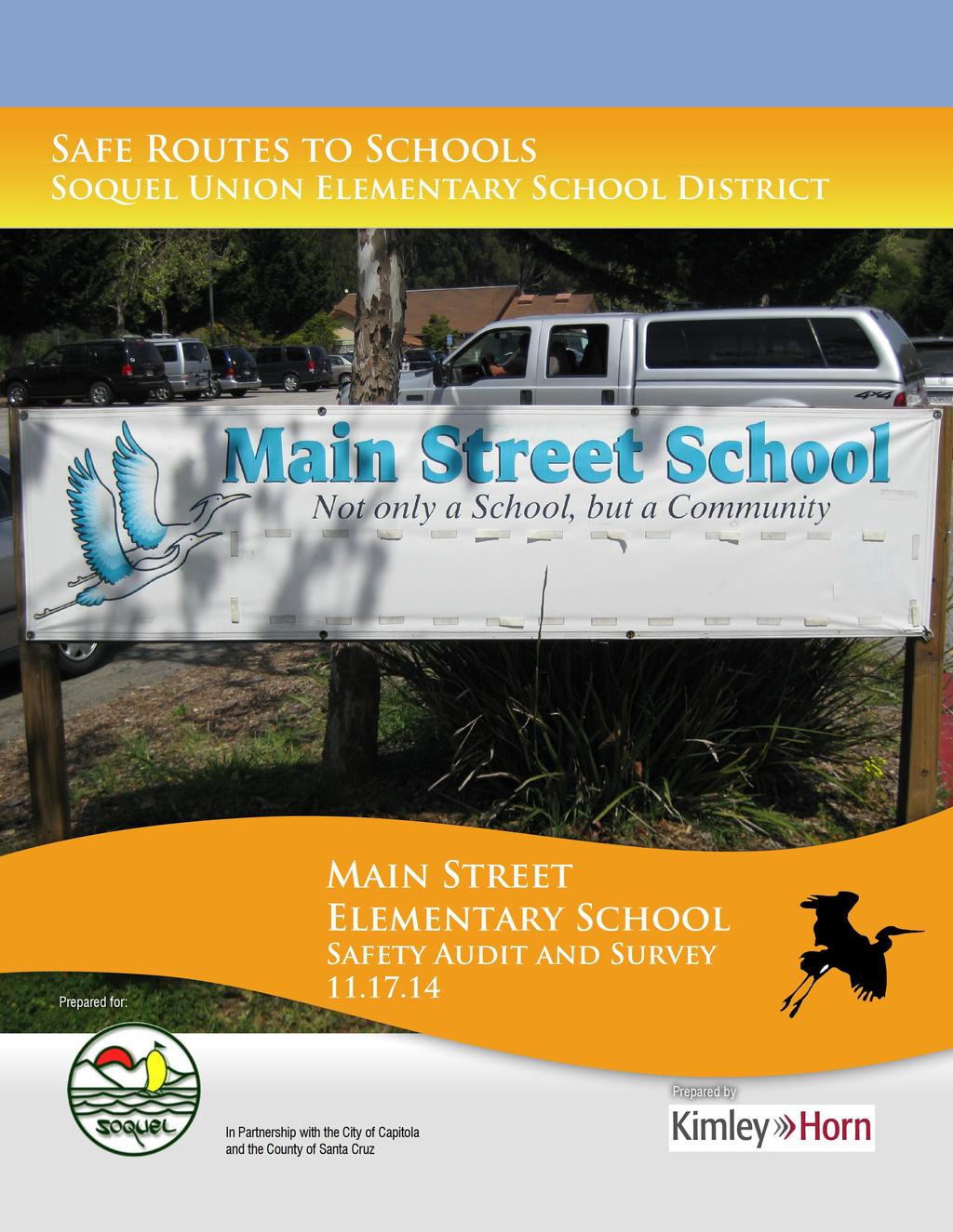
2 Contents Introduction... 2 Additional Safe Routes to School Resources Survey Results... 4 Field Audit... 6 Proposed Safe Routes to School Elements... 9 Typical Safe Routes to School Summary Safe Routes to School Safety Audit and Survey November 2014
3 INTRODUCTION In partnership with the City of Capitola and the County of Santa Cruz, the Soquel Union Elementary School District (SUESD) received a Safe Routes to School (SRTS) grant to complete Walking and Bicycling Audits at each of its elementary and middle school campuses. Walking and bicycling audits are field visits to identify barriers or challenges to students using these modes of transportation to travel between home and school. Also known as assessments, audits generally include a tour of the school area where participants identify issues related to walking and biking, followed by a debriefing and brainstorming session to rank high-priority concerns and identify potential solutions. Walking and bicycling audits provide community stakeholders with the information they need to analyze the design and condition of the transportation network. This report summarizes the results of a parent survey conducted in Spring of 2014, existing conditions and field observations from walking and bicycling audits, and recommendations for the City, County, and SUESD to improve walking and bicycling conditions. A Walking and Bicycling Audit was completed for on May 1, Staff and parents from, as well as staff from the Santa Cruz County and the District partnered with the selected engineering safety firm of Kimley-Horn to complete the field audit. This group constituted the site council for. Subsequent to the field audit, the site council met to discuss observations and concerns and brainstorm improvements. These observations and recommendations for improvements were incorporated into the Safe Routes to School Walking and Biking Audit Draft Report for, dated September 5, The Draft Report was reviewed by the site council and made available to a wider group for comment through inclusion in the SUESD Board October 15, 2014 meeting packet. Comments received on the Draft Report were reviewed and discussed at a follow-up meeting with the site council on October 29, This report, dated November 17, 2014, incorporates the agreed changes with the site council, and reflects the priorities to improving walking and bicycling conditions to Main Elementary School. ADDITIONAL SAFE ROUTES TO SCHOOL RESOURCES The City of Capitola and Santa Cruz County have both prepared studies and programs focused on providing safe walkways and pathways throughout their jurisdictions and specifically around schools. A brief list of those documents is included below for reference purposes: Santa Cruz County May 2012 Bike and Pedestrian Count Report City of Capitola Bicycle Plan County of Santa Cruz 2011 Bicycle Transportation Plan Sustainable Santa Cruz County Plan SCCRTC Final 2014 Regional Transportation Plan Safe Routes to School Safety Audit and Survey November

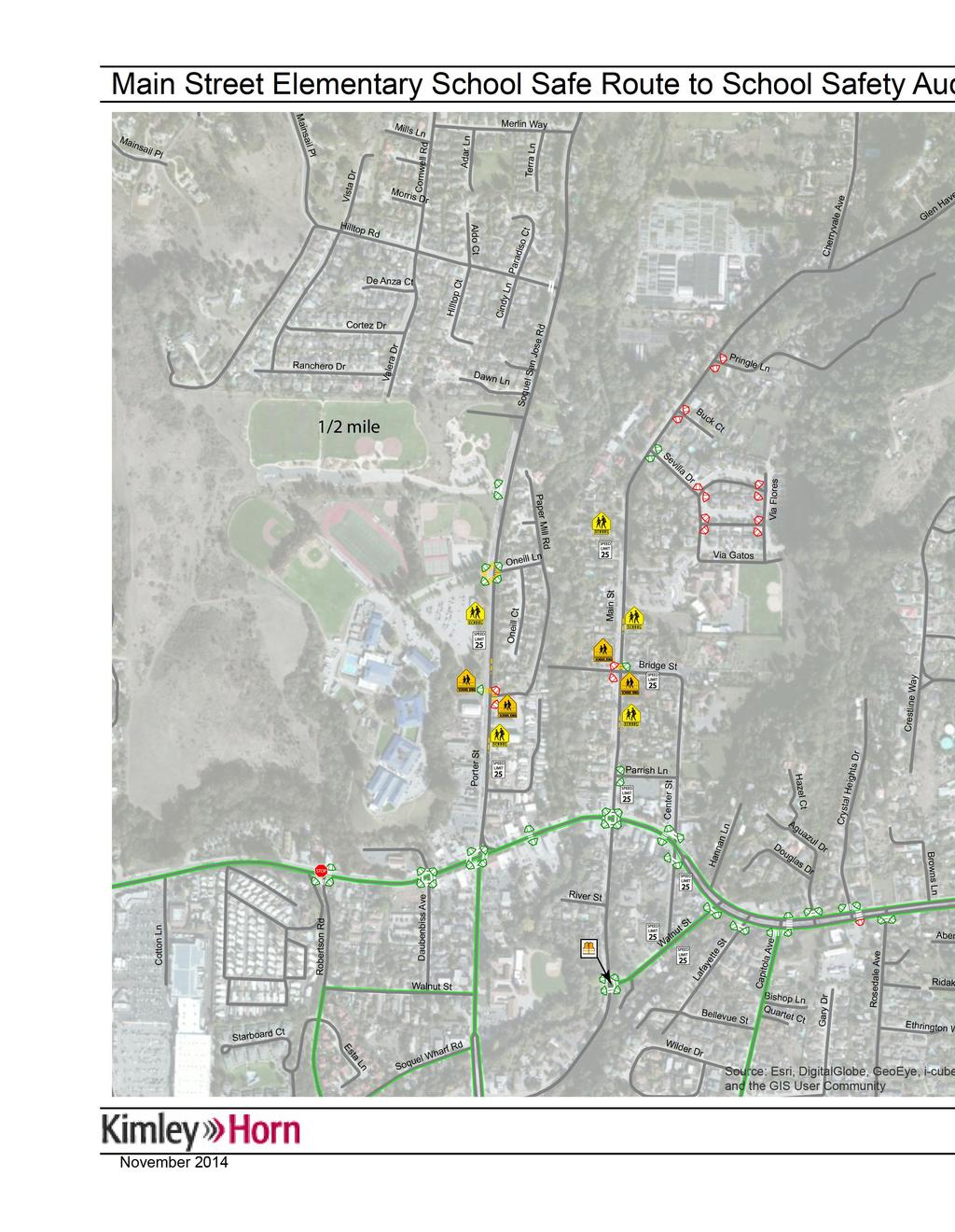
4 MAIN STREET ELEMENTARY SCHOOL Below is a map showing the and its surrounding area. For the 2013/2014 school year Main Street Elementary had an enrollment of 491 students. 3 Safe Routes to School Safety Audit and Survey November 2014

5 SURVEY RESULTS In Spring of 2014, a parent survey was conducted for. A total of 107 responses were collected. The number of responses varied per survey question and some questions allowed the selection of multiple answers. Below are a summary of the survey results related to Safe Route to Schools activities. Based on responses, 7 percent of students live within a quarter mile of school while 12 percent of students live within a half mile from school. Sixtytwo percent of students live more than a mile from school. Approximate Distance between Home and School Distance Number Percent ¼ mile or less 8 7% ¼ to ½ mile 5 5% ½ to 1 mile 28 26% 1 to 2 mile 36 34% 2 miles or more 30 28% Total % The main mode of transportation for all trips to and from school is private vehicles with 64 percent. The second and third most common means of getting to school is carpool at 18 percent and walking at 11 percent. The most common roadways used by private vehicles include Center Street, N Main Street, Porter Street, and Soquel Drive. The most common roadways used by pedestrian walking to school include Center Street, N Main Street, and Soquel Drive. The most common roadways used by bicyclists include Center Street, N Main Street and Soquel Drive. Safe Routes to School Safety Audit and Survey November

6 The survey inquired participants about what concerns or limitations that may hinder student s ability to walk or bike to/from school. The most common responses included speeding traffic along routes, too much traffic along route, no adult to walk or bike with, lack of sidewalks/paths, lack of bikeways, unsafe intersections, and stranger danger. Another question asked participants on which concerns, if they were addressed, would allow their students to walk or bike more to/from school. The most common responses include speeding traffic along route, too much traffic along route, no adult to walk or bike with, lack of sidewalks/paths, lack of bikeways, unsafe intersection, and stranger danger. 5 Safe Routes to School Safety Audit and Survey November 2014
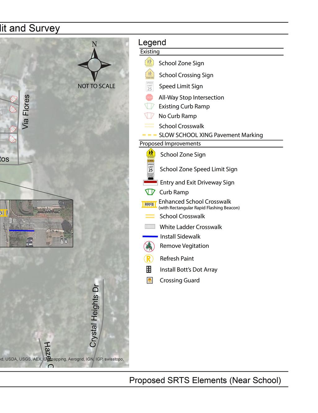
7 FIELD AUDIT The field audit at focused on the following main areas of concern by the group: Main Street (between Glen Haven Road and Soquel Drive): This section of Main Street experiences moderate level of pedestrian activity and moderate level of parking activity by parents. Some observations during the field audit include: o The school parking lots are located off of Main Street, north of Ladera Lane. The parking lot has a separate parking area for faculty and staff, as well as parking for parents to park and walk their students into class. In the school parking lot, there are two locations for student drop-off and pick-up. It was observed that the outer, larger loop was utilized more than the smaller inner loop. The queue for the drop-up and pick-up would extend onto Main Street until Bridge Street. This queue is managed by a school-assigned staff member who sets out cones and utilizes the curb-side no-parking area prior to the school entrance to manage the traffic queue while minimizing the impact to north/south traffic on Main Street. o It was observed that there was a lot of pedestrian activity on the exit driveway, but there are no sidewalks along the exit driveway. It may be recommended that sidewalks be installed adjacent to the school exit driveway. o There is no parking along Main Street between the school driveway and Bridge Street between 1:30 3:30 pm. Parents were seen parked along Bridge Street or Via Gatos. o The intersection of Main Street and Bridge Street has a yellow school crosswalk on the north leg, however it was observed that motorist often do not comply with the crossing. o On the east side of Main Street, there are no sidewalks south of Bridge Street. It is recommended that a sidewalk or pedestrian pathway be installed to close the pedestrian gap along Main Street. Center Street (between Bridge Street and Soquel Drive): This section of Center Street experiences a moderate level of vehicle traffic. o It was noted during the field audits, that parents would utilize Center Street rather than Main Street. o There were comments about possibly adding bike facilities on Center Street. Center Street is not wide enough to accommodate bike lanes, but bike Sharrows could be a possible option. o The intersection of Center Street and Soquel Drive was identified for not being very pedestrian friendly. Due to the lane geometry, vehicles may make a westbound right turn very fast. The crosswalk paint at this intersection is faded and vehicles not may stop at the crosswalks. Safe Routes to School Safety Audit and Survey November
8 Via Gatos (between Sevilla Drive and Via Flores): This section of Via Gatos experiences a moderate level of parking activity by parents. Some observations during the field audit include: o There is access to the school via stairs located on Via Gatos. It was observed that parents would park along Via Gatos and wait for students. o Drop-off and pickup activities along Via Gatos are discouraged by the school and signs posted outside school grounds discourage this activity as well. However, some students and parents are still using this location as an alternative to the drop-off and pickup activities in the school parking lot and along Main Street. Additional observations about walking and biking activities near the school campus: Signage: Generally the school zone signage is well maintained, although it is observed that not all of the school zone and school crossing signs are consistent with the current California MUTCD signage recommendation. Walking to campus: Observations as well as experience from the site council noted that a moderate volume of students walk to/from campus daily and this is the most highly used alternative transportation mode besides parents using personal vehicles. In addition, many students and parents were observed to park outside the school campus on adjoining roadways and walk into campus. Biking to campus: A moderate level of students was observed to bike or scooter to/from school. Bike racks are located near the front of the school drop-off and pickup area. On a daily basis, bike racks appear to experience moderate to heavy usage and long term additional bike storage may be required if more students choose to bike or scooter to school. The Existing SRTS Elements figure illustrates the existing pedestrian and bicycle safety devices already in place in the study area. 7 Safe Routes to School Safety Audit and Survey November 2014
9
, Medium-term (1-3 years), or Long-term (3+ years).")

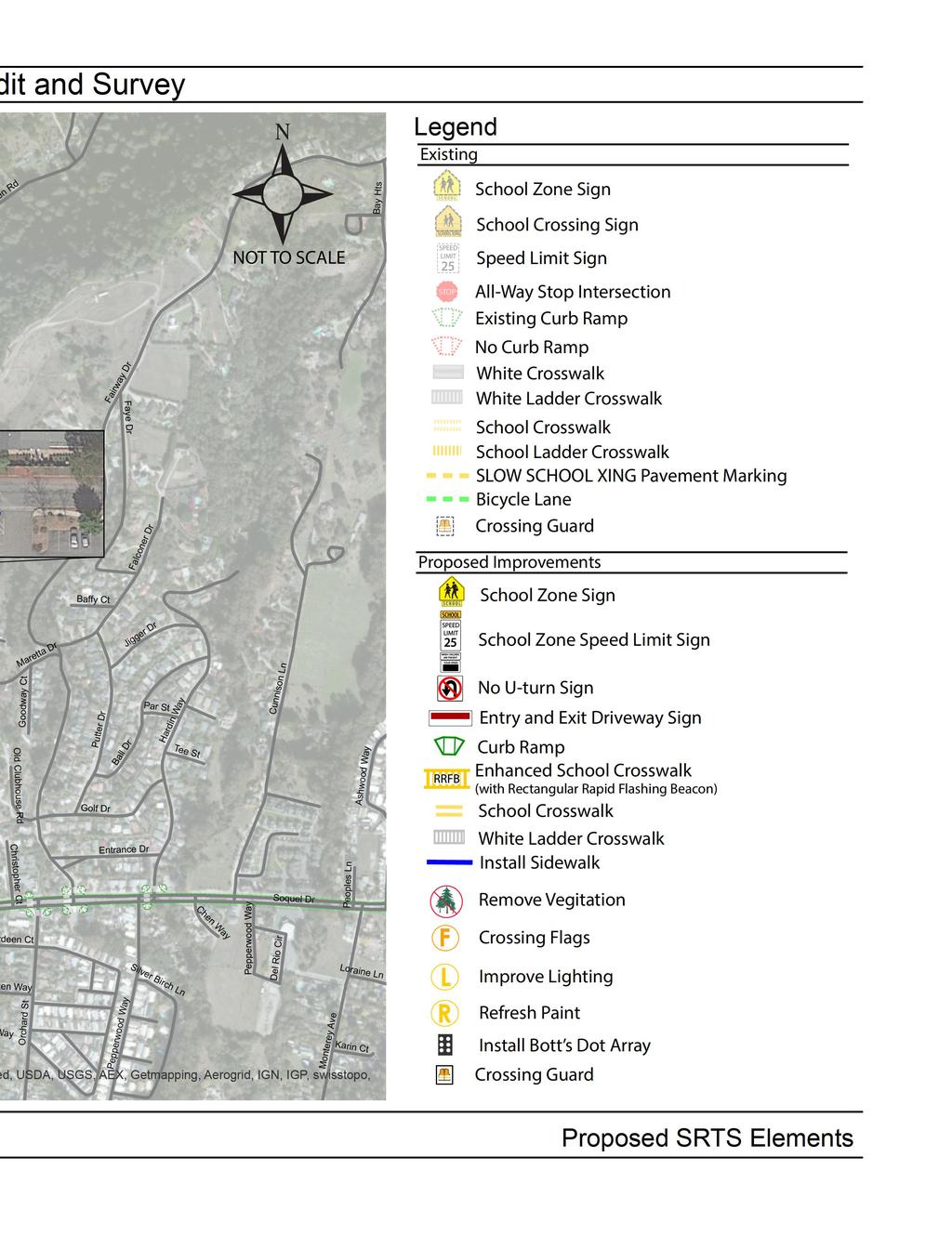
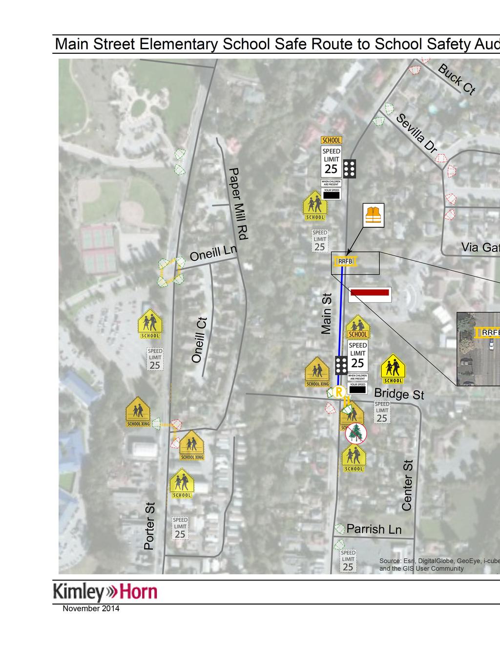
10 PROPOSED SAFE ROUTES TO SCHOOL ELEMENTS The Proposed SRTS Elements and Proposed SRTS Elements (Near School) figures illustrate the SRTS Plan on a conceptual basis. For project planning purposes, each improvement is estimated to occur in the Short-term (within 1 year), Medium-term (1-3 years), or Long-term (3+ years). In addition, the responsible lead agency is identified for each improvement. A brief discussion is provided below for each of the improvements proposed. Main Street (North to South): 1. Install School Speed Limit and Speed Feedback Sign: It is recommended that school speed limit signs be installed 500 feet away from the school along Main Street. For northbound traffic, the sign should be installed north of Bridge Street and south of Sevilla Drive for southbound traffic. It is recommended that speed feedback signs be installed in tandem with the School Speed Limit signs on Main Street. (Estimated time frame: Long-term, Responsible Lead Agency: County) 2. Install Bott s dot array: During the field audit it was mentioned that speeding was a problem along Main Street. Bott s dot arrays can be installed on the roadway to alert drivers of upcoming safety areas. It is suggested that Bott s dot arrays be installed on the roadway south of Sevilla Drive for southbound traffic and north of Bridge Street for northbound traffic. (Estimated time frame: Medium-term, Responsible Lead Agency: County) 3. Install RRFB crossing: It is recommended that a Rectangular Rapid Flashing Beacon (RRFB) be installed in front of the school to improve visibility for motorists of crossing pedestrians and specifically the elementary school students. The County has plans to implement this improvement and recently received a SRTS grant for funding of this improvement and others. (Estimated time frame: Medium-term, Responsible Lead Agency: County) 4. Crossing Guard: It is recommended that a crossing guard be instated at the proposed RRFB crossing in front of the school. (Estimated time frame: Shortterm, Responsible Lead Agency: SUESD) 5. Install Sidewalk: There is a high number of pedestrians which utilize the area around the exit driveway, however there is no sidewalk. It is suggested that an internal sidewalk be installed along the south side of exit school driveway between its current terminus at the parking lot and the public sidewalk at the edge of the property. (Estimated time frame: Medium-term, Responsible Lead Agency: SUESD) 9 Safe Routes to School Safety Audit and Survey November 2014
 7.")
 8. Install Sidewalk: Currently there is no sidewalk on the west side of Main Street north of Bridge Street.")
11 Bridge Street (East to West): 6. Install Hatching and move Stop Bar: It is recommended that hatching be installed between Main Street and the moved stopped bar. This hatching will create more space between vehicles exiting the school parking lot and pedestrians walking along Main Street. (Estimated time frame: Medium-term, Responsible Lead Agency: SUESD) 7. Install Entry Only and Exit Only Signs: It is recommended that the entry and exit school driveways be signed to prevent drivers from entering through the wrong driveways. (Estimated time frame: Short-term, Responsible Lead Agency: SUESD) 8. Install Sidewalk: Currently there is no sidewalk on the west side of Main Street north of Bridge Street. It is suggested that a sidewalk or dedicated pathway be installed. The County has noted that there are interim plans for constructing a sidewalk on the west side of Main Street from Bridge Street to the school crosswalk. (Estimated time frame: Long-term, Responsible Lead Agency: County) 9. Refresh Crosswalk: The paint for the crosswalk on the north leg of Main Street and Bridge Street is faded. It is proposed that the paint be refreshed. (Estimated time frame: Short-term, Responsible Lead Agency: County) 10. Install School Crosswalk: It is recommended that a school crosswalk be installed on the east leg of Main Street and Bridge Street. The school crosswalk notifies drivers of possible students crossing the road. (Estimated time frame: Short-term, Responsible Lead Agency: County) 11. Install Pedestrian Ramp: It is proposed that pedestrian ramps be installed on the northwest and southeast corner of Main Street and Bridge Street as a gap closure. (Estimated time frame: Medium-term, Responsible Lead Agency: County) 12. Trim Vegetation: There is overgrown vegetation along Main Street which can be a visual obstruction for drivers. It is proposed that the vegetation on the east side of Main Street, south of Bridge Street be trimmed. (Estimated time frame: Short-term, Responsible Lead Agency: County) 13. Install School Zone Sign: Many parents from east of the school utilize Center Street and Bridge Street to drop their students off at school. It is recommended that a school zone sign be installed near the intersection of Bridge Street and Main Street (along Bridge Street) to notify motorist they are entering a school zone. (Estimated time frame: Short-term, Responsible Lead Agency: County) Safe Routes to School Safety Audit and Survey November
12 Center Street (North to South): 14. Refresh Crosswalk and Improve Pedestrian Experience: It is recommended that the two crosswalks on the north leg crosswalk at Soquel Drive and Center Street be repainted. To improve the pedestrian experience by shortening the crossing distance for the north leg, it is recommended to make the northeast corner a tighter turning radius and to expand the pork-chop in the northwest corner to further shorten the pedestrian crossing distance. (Estimated time frame: Medium-term, Responsible Lead Agency: County) Overall School Zone Study Area: 15. A review was completed regarding the on-campus parking supply and setup, especially whether the faculty/staff parking lot should be converted to a parent/guest parking lot. It was determined that faculty/staff lot is already heavily utilized and removal of faculty/staff would most likely cause more all-day parking on adjacent streets. 16. Some of the current school-related roadway signage is not current based on the current version of the California Manual on Uniform Traffic Control Devices (MUTCD). This most recent version includes some updates to sign text and/or images, as well as standards for sign retro-reflectivity. It is recommended that future efforts for funding the elements of this plan also inventory the status of the current school signage and update all signs to the current standard. Specifically, many of the school zone and school crosswalk signs in the school area are based on previous sign standards and should be updated as other elements of the SRTS plan are implemented. Vehicular Drop-off and Pickup Procedures: 17. Although the primary goal of the Walk and Bike Audit is to encourage additional walking and biking through safety improvements of physical roadway features, the general safety of school areas is also observed. In the Main Street Elementary parking lot, there are two lanes for student drop-off and pick-up. It is suggested that the pick-up plan be reviewed to determine how to better utilize both pick-up loops. As noted in the existing observations, a larger number of parents utilize the larger loop immediately adjacent to the school buildings to conduct drop-off and pickup. The school may consider a pickup procedure by grade that then better utilizes the smaller loop during pickup to more efficiently move vehicles through the parking lot. Speed Limit in School Zone: 18. To aid in the enforcement of the speed limit along Soquel Drive, the County plans to conduct a revised Engineering and Traffic Survey in early This evaluation is required to enforce the posted speed limit and will assist the California Highway Patrol in better enforcement around the school area. 11 Safe Routes to School Safety Audit and Survey November 2014

13 Improvements for Soquel Elementary School: The half mile radius for Main Street Elementary and Soquel Elementary school overlap. The following SRTS improvements were recommended for Soquel Elementary School that is within the half mile radius of. 1. Install School Speed Limit Sign: It is recommended that school speed limit signs be installed 500 feet away from Soquel Elementary on Porter Street and Main Street. On Porter Street, the sign should be installed south of Soquel Drive for southbound traffic. Along Main Street, the sign should be installed north of River Street for southbound traffic. (Estimated time frame: Short-term, Responsible Lead Agency: County) 2. Clear Vegetation: On the east side of Main Street there is vegetation near the curb. It is suggested that this vegetation be cleared to make it easier for curbside drop-off and pick up. (Estimated time frame: Short-term, Responsible Lead Agency: County) 3. Install School Crossing: Currently the crosswalks at the intersection of Main Street and Walnut Street are white crosswalks. It is recommended that crosswalks be striped yellow. (Estimated time frame: Short-term, Responsible Lead Agency: County) 4. Install No U-Turn Sign: It was observed that many parents would drop off their children and then make a U-turn at Walnut Street. It is purposed that a No U-turn sign be installed near the intersection of Main Street and Walnut Street. (Estimated time frame: Medium-term, Responsible Lead Agency: County) 5. Install Pedestrian Crossing: Crosswalks help indicate to drivers the dedicated areas for pedestrians to cross the intersection. It is recommended that a crosswalk be installed on the west leg of Soquel Drive and Walnut Street. (Estimated time frame: Medium-term, Responsible Lead Agency: County) Safe Routes to School Safety Audit and Survey November
14
15
16 TYPICAL SAFE ROUTES TO SCHOOL SUMMARY More details of the recommended elements included herein, as well as other typical SRTS elements are summarized in the table below. ST2S Element SIGNS SCHOOL SPEED LIMIT SPEED LIMIT FEEDBACK NO PARKING ANYTIME Application in accordance with: California MUTCD, Part 7, Section 7B.11 (School Speed Limit Assembly C (CA)) California MUTCD, Part 2, Sections 2B.13 (Vehicle Speed Feedback Sign) California MUTCD, Part 7, Section 7B.14 (R26(CA)) Image Dimensions (W x H) (24 x 8 ) + (18 x 24 ) + (24 x 10 ) (30 x 30 ) (12 x 18 ) Typical purpose To indicated the speed limit where a reduce speed zone for a school area has been established To display to approaching drivers the speed at which they are traveling. Enhances driver awareness of their speed, especially when used in condition with speed limit sign (R2-1) To prevent parked or waiting vehicles from blocking pedestrians views, and drivers view of pedestrians Typical Cost Range $300 - $500 $12, $17, 500 $300 - $500 NO STOPPING ANYTIME California MUTCD Part 2, Section 2B.39 (R26(S)(CA)) (12 x 18 ) To inform motorist of a no stopping zone at a specific location where red curb marking is not used. $300 - $500 SCHOOL PASSENGER LOADING ONLY California MUTCD, Part 2, Section 2B.39 (R25D(CA)) (12 x 18 ) To inform motorist of curb restriction at location for loading or unloading passengers for the time as specified by local ordinance. $300 - $500 PEDESTRIAN ELEMENTS SCHOOL CROSSING WARNING SIGN California MUTCD, Part 7, Section 7B.08 (School Warning Assembly A (CA)) (30 x 30 ) + (24 x 8 ) Installed at marked crosswalk, or as close to it as possible to show the location of the school crossing. $300 - $500 PEDESTRIAN COUNTDOWN SIGNAL RECTANGULAR RAPID FLASHING BEACON (RRFB) IN-ROADWAY LIGHTS California MUTCD, Part 4, Section 4E.07 Federal High Administration approval per California MUTCD, Section 1A.10, Approval No. IA RRFB-California Statewide California MUTCD Part 4, Chapter 4L Beacon (4 x 29 ) + Warning Signs ~10 deep x ~7.5 Diameter To inform pedestrians of the number of seconds remaining in the pedestrian change interval. For use at uncontrolled pedestrian and school crosswalk locations. To warn road users that they are approaching a condition on or adjacent to the roadway that might not be readily apparent and might require the road user to slow down and/or come to a stop. $1,500 $50,000 $50,000 CURB RAMP Caltrans 2010 Standard Plan A88A and A88B Varies To make sidewalks accessible for those who need mobility or visual assistance. $500 - $800 BICYCLE ELEMENTS BICYCLE LANE California MUTCD, Part 9, Section 9C.04 Varies Pavement marking designated that portion of the roadway for preferential use by bicyclists. $100-$150 per bike and arrow BICYCLE LANE SIGN California MUTCD, Part 9, Section 9B.04 (R81(CA)) (12 x 8 ) Installed at the beginning of each designated Bike Lane and along each Bike Lane at all major changes to regulated bicycle and motor vehicle traffic. $300 - $500 NO PARKING BIKE LANE SIGN California MUTCD, Part 9, Section 9B.10 (R7-9) (12 x 18 ) To restrict parking, standing, or stopping in a bicycle lane. $300 - $500 BICYCLE + SHARE THE ROAD California MUTCD, Part 9, Section 9B.18 (W W16-1) (30 x30 ) + (18 x 24 ) To warn motorist to watch for bicyclists traveling along the highway. $300 - $500 ROADWAY IMPROVEMENTS CURB EXTENSIONS City Jurisdiction Varies Improves safety for pedestrians and motorist at intersection. Increases visibility and reduces speed of turning vehicles. Varies RAISED PEDESTRIAN CROSSINGS City Jurisdiction Varies Improves safety for pedestrians by increases visibility for drivers and reduces speed of vehicles. Varies SLOW SCHOOL XING PAVEMENT MARKINGS California MUTCD, Part 7, Section 7C. 06 (7C-101 (CA) N/A Warning drivers in advance of all yellow school crosswalks. $ Safe Routes to School Safety Audit and Survey November 2014
 Rick Boyce John Cannow Nicole Douglas Jim Dupre")


17 SRTS Safety Audit Site Council School Staff, Faculty, Parents, and Students Participating Annette Bitter (Principal) Rick Boyce John Cannow Nicole Douglas Jim Dupre Chris Hadland Martin Kemsley Stephanie Musbach Brad Sadek Jack Sohriakoff Rebecca Voigf Laura Wickman Soquel Union Elementary School District Harley Robertson Kimley-Horn and Associates, Inc. Mike Mowery, P.E Santa Cruz County Jack Sohriakoff
C/CAG. Sunnybrae Elementary School Walking and Bicycling Audit. San Mateo-Foster City School District JUNE 2013
 Sunnybrae Elementary School Walking and Bicycling Audit JUNE 2013 San Mateo-Foster City School District C/CAG City/County Association of Governments of San Mateo County SUNNYBRAE ELEMENTARY SCHOOL WALKING
Hidden Oaks Elementary School
 Hidden Oaks Elementary School SCHOOL ROUTE PLAN For HIDDEN OAKS ELEMENTARY SCHOOL LOCATION 13 ORANGE COUNTY Prepared for: ORANGE COUNTY SCHOOL ASSESSMENT PROGRAM ORANGE COUNTY PUBLIC WORKS Traffic Engineering
Drag and drop pic and stretch/crop to the limits of the blue rectangle (delete this text box) Maxey Elementary School
 Maxey Elementary School") Drag and drop pic and stretch/crop to the limits of the blue rectangle (delete this text box) Maxey Elementary School SCHOOL ROUTE PLAN For MAXEY ELEMENTARY SCHOOL LOCATION 33 ORANGE COUNTY Prepared for:
Drag and drop pic and stretch/crop to the limits of the blue rectangle (delete this text box) Maxey Elementary School SCHOOL ROUTE PLAN For MAXEY ELEMENTARY SCHOOL LOCATION 33 ORANGE COUNTY Prepared for:
Orange Center Elementary School
 Drag and drop pic and stretch/crop to the limits of the blue rectangle (delete this text box) Orange Center Elementary School Drag and drop pic and stretch/crop to the limits of the blue rectangle (delete
Meadow Woods Elementary School
 Drag and drop pic and stretch/crop to the limits of the blue rectangle (delete this text box) Meadow Woods Elementary School Drag and drop pic and stretch/crop to the limits of the blue rectangle (delete
Lake Whitney Elementary School
 Lake Whitney Elementary School SCHOOL ROUTE PLAN For LAKE WHITNEY ELEMENTARY SCHOOL LOCATION 18 ORANGE COUNTY Prepared for: ORANGE COUNTY SCHOOL ASSESSMENT PROGRAM ORANGE COUNTY PUBLIC WORKS Traffic Engineering
Windy Ridge Elementary School
 Windy Ridge Elementary School SCHOOL ROUTE PLAN For WINDY RIDGE ELEMENTARY SCHOOL LOCATION 54 ORANGE COUNTY Prepared for: ORANGE COUNTY SCHOOL ASSESSMENT PROGRAM ORANGE COUNTY PUBLIC WORKS Traffic Engineering
City of Albert Lea Policy and Procedure Manual 4.10 ALBERT LEA CROSSWALK POLICY
 4.10 ALBERT LEA CROSSWALK POLICY PURPOSE: Pedestrian crosswalks are an integral part of our transportation infrastructure. To be effective and promote safety, marked crosswalks must be installed after
SAFE ROUTES TO SCHOOL
 SAFE ROUTES TO SCHOOL Forest Ridge Elementary School Existing Conditions and ACTION PLAN > Oak Creek - Franklin Joint School District Table of Contents CONTEXT Enrollment Boundaries
July 5, Arthur R. Ware, Jr. Elementary School 2017 Safe Routes to School Walkabout Report
 July 5, 2017 Arthur R. Ware, Jr. Elementary School 2017 Safe Routes to School Walkabout Report 1 Walkabout Report Introduction On April 28, 2017, City, School, and SAWMPO staff met to conduct a Safe Routes
SAFE ROUTES TO SCHOOL
 SAFE ROUTES TO SCHOOL Edgewood Elementary School Existing Conditions and ACTION PLAN > Oak Creek - Franklin Joint School District Table of Contents CONTEXT Enrollment Boundaries Enrollment
Appendix T CCMP TRAIL TRAFFIC & TRANSPORTATION DESIGN STANDARD
 Appendix T CCMP 3.3.4 TRAIL TRAFFIC & TRANSPORTATION DESIGN STANDARD 3.3.4 Trail Traffic and Transportation Design Multi-use trails have certain design standards, which vary depending on the agency that
SCHOOL ROUTE PLAN. For HUNTER S CREEK ELEMENTARY SCHOOL LOCATION 14 ORANGE COUNTY. Prepared for:
 SCHOOL ROUTE PLAN For HUNTER S CREEK ELEMENTARY SCHOOL LOCATION 14 ORANGE COUNTY Prepared for: ORANGE COUNTY SCHOOL ASSESSMENT PROGRAM ORANGE COUNTY PUBLIC WORKS Traffic Engineering Division 42 South John
Agenda. Overview PRINCE GEORGE S PLAZA METRO AREA PEDESTRIAN PLAN
 PRINCE GEORGE S PLAZA METRO AREA PEDESTRIAN PLAN May 28, 2008 Agenda Welcome and introductions Project overview and issue identification Planning context and strengths Design challenges and initial recommendations
Transportation Planning Division
 Transportation Planning Division Presentation Outline Study Tasks Recap of Previous Meetings Data Collected Focus Areas within Study Limits Design Principles Tool Box Recommended Concepts Schedule Moving
Durrance Elementary School
 Durrance Elementary School SCHOOL ROUTE PLAN For DURRANCE ELEMENTARY SCHOOL LOCATION 9 ORANGE COUNTY Prepared for: ORANGE COUNTY SCHOOL ASSESSMENT PROGRAM ORANGE COUNTY PUBLIC WORKS Traffic Engineering
CITY OF KASSON TRANSPORTATION ALTERNATIVES KASSON SAFE ROUTES TO SCHOOL
 ve ha 8t G B A Mantorville Ave N 240th Ave 16th St NE 11th Ave NE K-M HIGH SCHOOL SUNRISE TRAIL TO MANTORVILLE MNTH 57 SUNSET TRAIL TO MANTORVILLE NE PARK 16TH ST NE TRAIL K-M ELEMENTARY SCHOOL K-M MIDDLE
MEMORANDUM. Discussion of the planned crosswalk improvement on Mount Vernon Road near Stratham Drive
 MEMORANDUM To: From: Mayor and City Council Michael Smith, Public Works Director Date: August 24, 2015 Subject: Discussion of the Mount Vernon Road Crosswalk Improvement ITEM DESCRIPTION Discussion of
PRINCE GEORGE S PLAZA METRO AREA PEDESTRIAN PLAN
 PRINCE GEORGE S PLAZA METRO AREA PEDESTRIAN PLAN May 28, 2008 Agenda Welcome and introductions Project overview and issue identification Planning context and strengths Design challenges and initial recommendations
Cycle Track Design Best Practices Cycle Track Sections
 Design Best Practices Sections It is along street segments where the separation and protection methods of cycle tracks offer more comfort than conventional bicycle lanes, and are more attractive to a wide
AGENDA ITEM 6 D THOMASVILLE ROAD (HERMITAGE BOULEVARD TO LIVE OAK PLANTATION ROAD) ROADWAY SAFETY AUDIT
 ROADWAY SAFETY AUDIT") May 15, 2018 AGENDA ITEM 6 D THOMASVILLE ROAD (HERMITAGE BOULEVARD TO LIVE OAK PLANTATION ROAD) ROADWAY SAFETY AUDIT TYPE OF ITEM: Discussion STATEMENT OF ISSUE The Florida Department of Transportation
May 15, 2018 AGENDA ITEM 6 D THOMASVILLE ROAD (HERMITAGE BOULEVARD TO LIVE OAK PLANTATION ROAD) ROADWAY SAFETY AUDIT TYPE OF ITEM: Discussion STATEMENT OF ISSUE The Florida Department of Transportation
Draft North Industrial Area-Wide Traffic Plan
 Summary of North Industrial and Hudson Bay Industrial Recommended Improvements Table 1. Summary of s Item Location 1 2 3 4 5 6 7 8 9 10 11 12 Millar Ave north of 51st St Super 8 Motel back lane 400 Block
Arlington Public Schools Thomas Jefferson Site Evaluation Transportation Networks. Thomas Jefferson Working Group Meeting #6 November 10, 2014
 Arlington Public Schools Thomas Jefferson Site Evaluation Transportation Networks Thomas Jefferson Working Group Meeting #6 November 10, 2014 2 3 INTRODUCTION 4 Goal of our work: Identify and assess multi-modal
Walkabout Summary Report
 Walkabout Summary Report Introduction On September 3, 2014, stakeholders at Bessie Weller Elementary School (Bessie Weller ES) in Staunton, Virginia met to examine the walking and bicycling network around
NM-POLICY 1: Improve service levels, participation, and options for non-motorized transportation modes throughout the County.
 Transportation PRINCE WILLIAM COUNTY 2008 COMPREHENSIVE PLAN NON-MOTORIZED PLAN CONTENTS Goals, Policies, and Action Strategies Table 4 (Bike Facility Classifications and Descriptions) Table 5 (Bike Facility
TRAFFIC MANAGEMENT PLAN
 292 84 140440 TRAFFIC MANAGEMENT PLAN The purpose of the Traffic Management Plan (TMP) is to have established procedures for traffic flow and circulation around the elementary school related to student
Vallecito Elementary School. Travel Plan
 Vallecito Elementary School Travel Plan TABLE OF CONTENTS 1. PURPOSE... 1 1.1. SR2S PLANNING, IMPLEMENTATION AND MONITORING... 1 1.2. MARIN COUNTY MEASURE A... 1 2. VALLECITO ELEMENTARY SCHOOL PROFILE...
Implementing the Three Es of School Zone Traffic Calming
 Implementing the Three Es of School Zone Traffic Calming Use this evaluation tool as a guide to analyze the specific safety needs of your school. SCHOOL PROFILE School Name: School District: Address: Phone
Active Transportation Facility Glossary
 Active Transportation Facility Glossary This document defines different active transportation facilities and suggests appropriate corridor types. Click on a facility type to jump to its definition. Bike
TRAVEL PLAN: CENTRAL EUROPEAN UNIVERSITY CAMPUS REDEVELOPMENT PROJECT TRAVEL PLAN. Central European University Campus Redevelopment Project.
 TRAVEL PLAN Central European University Campus Redevelopment Project Page 1 Table of Contents Introduction... 3 Background... 7 Building Users... 7 Transportation in Community Consultation... 7 Summary
CITY OF OAK CREEK SAFE ROUTES TO SCHOOL ACTION PLAN. East Middle School
 CITY OF OAK CREEK SAFE ROUTES TO SCHOOL ACTION PLAN East Middle School CITY OF OAK CREEK SAFE ROUTES TO SCHOOL ACTION PLAN East Middle School Why Safe Routes to School? Safe Routes to School ( SRTS ) is
Safe Routes to School Action Plan Aberdeen, Idaho
 Background Aberdeen, Idaho is a largely agricultural community of nearly 2,000 people and is located in the southeast portion of the state on the western edge of American Falls Reservoir. The community
Off-road Trails. Guidance
 Off-road Trails Off-road trails are shared use paths located on an independent alignment that provide two-way travel for people walking, bicycling, and other non-motorized users. Trails specifically along
SAN FRANCISCO MUNICIPAL TRANSPORTATION AGENCY
 THIS PRINT COVERS CALENDAR ITEM NO. : 10.3 DIVISION: Sustainable Streets Division BRIEF DESCRIPTION: SAN FRANCISCO MUNICIPAL TRANSPORTATION AGENCY Approving traffic and parking modifications to install
APPENDIX A: Complete Streets Checklist DRAFT NOVEMBER 2016
 APPENDIX A: Complete Streets Checklist DRAFT NOVEMBER 2016 Complete Streets Checklist MetroPlan Orlando s Complete Streets Checklist is an internal planning tool for staff to further implementation of
DEPARTMENT OF ENVIRONMENTAL SERVICES. North Harrison Street (Lee Highway to Little Falls Road) Comparative Analysis. Prepared for:
 Comparative Analysis. Prepared for:") DEPARTMENT OF ENVIRONMENTAL SERVICES North Harrison Street (Lee Highway to Little Falls Road) Comparative Analysis Prepared for: Arlington County Department of Environmental Services 2100 Clarendon Boulevard,
DEPARTMENT OF ENVIRONMENTAL SERVICES North Harrison Street (Lee Highway to Little Falls Road) Comparative Analysis Prepared for: Arlington County Department of Environmental Services 2100 Clarendon Boulevard,
CRESTON ROAD COMPLETE AND SUSTAINABLE STREETS CORRIDOR PLAN
 CRESTON ROAD COMPLETE AND SUSTAINABLE STREETS CORRIDOR PLAN Preferred Plan Community Presentation September 27, 2017 City of El Paso de Robles in partnership with: Local Government Commission, W-Trans,
TEMPORARY TRAFFIC CONTROL GUIDELINES FOR HIGHWAY-RAIL GRADE CROSSINGS
 TEMPORARY TRAFFIC CONTROL GUIDELINES FOR HIGHWAY-RAIL GRADE CROSSINGS 1.0 INTRODUCTION 1.1 Purpose The Southern California Regional Rail Authority (SCRRA) is the designated track owner of the Metrolink
CITY OF SARATOGA SPRINGS PEDESTRIAN CROSSING TOOLBOX
 CITY OF SARATOGA SPRINGS PEDESTRIAN CROSSING TOOLBOX This toolbox is to be used to guide pedestrian crossing improvements within the City of Saratoga Springs. Details for each crossing type are provided.
Caltrans Sloat Boulevard Pedestrian Safety Project Response to Community Questions, Comments & Concerns
 Caltrans Sloat Boulevard Pedestrian Safety Project Response to Community Questions, Comments & Concerns Revised: May 10, 2016 The California Department of Transportation (Caltrans) is planning various
TABLE OF CONTENTS. Executive Summary
 Executive Summary Background... ES-1 Pedestrian Network... ES-2 Bikeway Network... ES-2 Collision History... ES-2 Public Input... ES-4 Conclusions and Recommendations... ES-4 1. Introduction and Setting
REGIONAL BICYCLE AND PEDESTRIAN DESIGN GUIDELINES
 REGIONAL BICYCLE AND PEDESTRIAN DESIGN GUIDELINES November 16, 2011 Deb Humphreys North Central Texas Council of Governments Bicycle and Pedestrian Advisory Committee Snapshot of the Guide 1. Introduction
Chapter 5: Crossing the Street
 Chapter 5: Crossing the Street Whether walking or bicycling, a student s journey to school will more than likely require crossing one or more streets. Per the Safe Routes to School Guide, maintained by
Watertown Complete Streets Prioritization Plan. Public Meeting #1 December 14, 2017
 Watertown Complete Streets Prioritization Plan Public Meeting #1 December 14, 2017 Goals for Public Meeting Overview of MassDOT Complete Streets Funding Program Educate the community on Complete Streets
Improvements Infrastructure Gap Assessment and Improvements Street Striping
 Infrastructure Project Proposal The federal-aid Safe Routes to School program funds infrastructure/engineering projects that fall into two categories: Design (available only to School Development Authority
MEMORANDUM. Charlotte Fleetwood, Transportation Planner
 MEMORANDUM Date: Updated August 22, 2017 To: Organization: Charlotte Fleetwood, Transportation Planner Boston Transportation Department From: Jason DeGray, P.E., PTOE, Regional Director of Engineering
ATTACHMENT NO. 11. RRLRT No. 2. Railroad / Light Rail Transit Technical Committee TECHNICAL COMMITTEE: Busway Grade Crossings STATUS/DATE OF ACTION
 ATTACHMENT NO. 11 RRLRT No. 2 TECHNICAL COMMITTEE: TOPIC: Railroad / Light Rail Transit Technical Committee Busway Grade Crossings STATUS/DATE OF ACTION RRLRT TC Draft: 06/23/2011 RRLRT TC Approval: 06/27/2014
LTAC: Katie Mencarini, Central & Hampton Roads streets and a fifteen minute debrief to discuss the findings. Participants walked along Mill Road
 Walkabout Summary On June 3, 2013, five participants met at Glen Allen Elementary School in Glen Allen, Virginia to take a closer look at the walking and biking network around the school. In addition to
Corpus Christi Metropolitan Transportation Plan Fiscal Year Introduction:
 Introduction: The Safe, Accountable, Flexible, Efficient Transportation Equity Act: A Legacy for Users (SAFETEA-LU) has continued the efforts started through the Intermodal Surface Transportation Efficiency
Memorandum. Sunday, July 13, Saturday, July 19, 2014
 Memorandum To: David Lowin, Brooklyn Bridge Park Corporation From: Daniel Schack, AICP, PTP Date: Re: Brooklyn Bridge Park Pier 5/6 Loop Road Traffic Study Project No: 14-01-2407 At the request of Brooklyn
Hedgepeth Williams Middle School and Paul Robeson Elementary School Trenton, NJ. School Travel Plan
 Hedgepeth Williams Middle School and Paul Robeson Elementary School Trenton, NJ School Travel Plan Hedgepeth Williams Middle School Description: Hedgepeth-Williams Middle School is located at 301 Gladstone
About the Studio. Edward J. Bloustein School of Planning and Public Policy - Rutgers University
 About the Studio Edward J. Bloustein School of Planning and Public Policy - Rutgers University Purpose of studio: Help City of Bayonne apply for Safe Routes to School (SRTS) funding by producing a School
S A F E R O U T E S T O S C H O O L H E R M A N TOW N S C H O O L S A N D P R O C TO R S C H O O L S P L A N A P P R OVA L S
 S A F E R O U T E S T O S C H O O L H E R M A N TOW N S C H O O L S A N D P R O C TO R S C H O O L S P L A N A P P R OVA L S WHAT IS SAFE ROUTES TO SCHOOL? In 1969, nearly 50% of children walked or rode
Crosswalk Policy Revisions & Pedestrian & Bicycle Connection Plans. Presentation to Sanibel City Council July 16, 2013
 Crosswalk Policy Revisions & Pedestrian & Bicycle Connection Plans Presentation to Sanibel City Council July 16, 2013 Outline Crosswalk Policy Revisions Minimum Standards Goals and Objectives Pedestrian
Summary: Mercer County Princeton Avenue & Spruce Street Study January 2009
 Summary: Several recent studies have assessed potential development and redevelopment opportunities in the Mercer Crossing area of Trenton, Ewing, and Lawrence. This Princeton Avenue and Spruce Street
NJDOT Complete Streets Checklist
 Background The New Jersey Department of Transportation s Complete Streets Policy promotes a comprehensive, integrated, connected multi-modal network by providing connections to bicycling and walking trip
MEMORANDUM. Date: 9/13/2016. Citywide Crosswalk Policy
 MEMORANDUM Date: 9/13/2016 Re: Citywide Crosswalk Policy Foreword Through the s Circulation Element and Complete Streets Policy, it is the City s goal to promote walking trips and provide safe facilities
Forest Hills Improvement Initiative
 Forest Hills Improvement Initiative Transportation Action Plan Short Term Recommendations ONLY Final Draft as of April 30, 2008 For Community Review and Feedback Prepared for: The City of Boston Boston
BIKE PLAN CONTENTS GATEWAY
 CONTENTS Acknowledgments...vii Great Rivers Greenway District Board of Directors... vii Great Rivers Greenway District Staff... vii Project Consultants... vii Committees... viii Citizens Advisory Committee
Recommendations. Central Salem Mobility Study
 Central Salem Mobility Study The Central Salem Mobility Study evaluated a range of multimodal transportation issues affecting downtown Salem, including circulation, access, and safety for people traveling
CTDOT Pedestrian and Bicycle Safety Initiatives
 CTDOT Pedestrian and Bicycle Safety Initiatives 2017 Northeast Transportation Safety Conference Mark F. Carlino, P.E. Traffic Engineering Division Chief Bureau of Engineering and Construction Connecticut
Bremen Elementary. SAFE ROUTES TO SCHOOL TRAVEL PLAN October 9, 2012
 Bremen Elementary SAFE ROUTES TO SCHOOL TRAVEL PLAN October 9, 2012 Introduction The purpose of the Bremen Elementary Safe Route to School (SRTS) Plan is to encourage school age children to travel to school
o n - m o t o r i z e d transportation is an overlooked element that can greatly enhance the overall quality of life for the community s residents.
 N o n - m o t o r i z e d transportation is an overlooked element that can greatly enhance the overall quality of life for the community s residents. 84 Transportation CHAPTER 11 INTRODUCTION Transportation
Comments EXECUTIVE SUMMARY
 Comments 1. Under any Alternatives, MCDOT should provide better at-grade pedestrian crossing of Georgia Avenue and Forest Glen Road, including improved crosswalks with wider medians and adequate signal
TRAFFIC ACTION PLAN. Laurie Meadows Neighborhood CITY OF SAN MATEO
 TRAFFIC ACTION PLAN Laurie Meadows Neighborhood CITY OF SAN MATEO Draft January 2017 Table of Contents Introduction... 2 The Traffic Forum Process... 5 Neighborhood Traffic Issues... 7 Neighborhood Recommendations
Chapter 4.3 Enterprise Elementary. Volusia County MPO. March Page 7.0
 Chapter 4.3 Enterprise Elementary Enterprise, FL Volusia County MPO March 2008 Page 7.0 Volusia County MPO Bicycle and Pedestrian School Safety Review Study Introduction Enterprise Elementary School is
C. Brian Shamburger, P.E., PTOE Kimley-Horn and Associates, Inc. State of Texas Registered Firm #928
 TECHNICAL MEMORANDUM To: From: Mr. Douglas G. Williams Director Transportation Services Texas A&M University C. Brian Shamburger, P.E., PTOE Kimley-Horn and Associates, Inc. State of Texas Registered Firm
City of Scotts Valley CITY COUNCIL STAFF REPORT
 DATE: April 19, 2017 City of Scotts Valley CITY COUNCIL STAFF REPORT AGENDA ITEM 2 DATE: 4-19-2017 TO: FROM: APPROVED: SUBJECT: Honorable Mayor and City Council Scott Hamby, Public Works Director Jenny
Chapter 2: Standards for Access, Non-Motorized, and Transit
 Standards for Access, Non-Motorized, and Transit Chapter 2: Standards for Access, Non-Motorized, and Transit The Washtenaw County Access Management Plan was developed based on the analysis of existing
MINNEAPOLIS PARK & RECREATION BOARD DRAFT TRAIL DESIGN STANDARDS FOR: SIGNS AND PAVEMENT MARKINGS
 MINNEAPOLIS PARK & RECREATION BOARD DRAFT TRAIL DESIGN STANDARDS FOR: SIGNS AND PAVEMENT MARKINGS October 14, 2014 CHANGE LOG Additions and changes to this document should be summarized on this page and
Coquitlam Cross-town Bike Route Improving Bicycle Facilities in a Mature Suburban Environment
 Coquitlam Cross-town Bike Route Improving Bicycle Facilities in a Mature Suburban Environment Sarah Rocchi, Vice-President, Projects, Opus International Consultants (Main Presenter) Catherine Mohoruk,
CITY OF OTTAWA ROADWAY MODIFICATION APPROVAL UNDER DELEGATED AUTHORITY
 RMA-2015-ATM-038 CITY OF OTTAWA ROADWAY MODIFICATION APPROVAL UNDER DELEGATED AUTHORITY DATE: April 22, 2015 SUBJECT Approval of Roadway Modifications Recommended through an Area Traffic Management Study
2 Mark Twain Elementary School Report
 2 Mark Twain Elementary School Report Principal: Greg Kaatz Grades: K-2 Enrollment: 323 Address: 425 N. Church Street First bell: 8:10 a.m. Silverton, OR 97381 Last bell: 2:30 p.m. Free & Reduced Lunch:
10.0 CURB EXTENSIONS GUIDELINE
 10.0 CURB EXTENSIONS GUIDELINE Road Engineering Design Guidelines Version 1.0 March 2017 City of Toronto, Transportation Services City of Toronto Page 0 Background In early 2014, Transportation Services
COMMUNITY MEETING AGENDA
 COMMUNITY MEETING AGENDA Welcome and Introductions SAFE Presentation Project Presentation Priorities Feedback Next Steps Q&A Santa Cruz Avenue Corridor Study 1 Santa Cruz Avenue Corridor Study Community
May 4, Dear Mr. Thomas and Mr. Snyder,
 Daniel Thomas, Principal Planner Christopher Snyder, County Engineer DuPage County Division of Transportation 421 N County Farm Road Wheaton, IL 60187 May 4, 2016 Dear Mr. Thomas and Mr. Snyder, On behalf
TRAFFIC ACTION PLAN. North Central Neighborhood CITY OF SAN MATEO
 TRAFFIC ACTION PLAN North Central Neighborhood CITY OF SAN MATEO Draft February 2017 Table of Contents Introduction... 1 The Traffic Forum Process... 4 Neighborhood Traffic Issues... 6 Neighborhood Recommendations
TRAFFIC ACTION PLAN. Central Neighborhood CITY OF SAN MATEO
 TRAFFIC ACTION PLAN Central Neighborhood CITY OF SAN MATEO Draft January 2017 Table of Contents Introduction... 1 The Traffic Forum Process... 4 Neighborhood Traffic Issues... 7 Neighborhood Recommendations
Chapter VISION, MISSION, AND GOALS AND OBJECTIVES. Vision. Mission. Goals and Objectives CONNECTING COMMUNITIES ACROSS THE ST.
 VISION, MISSION, AND GOALS AND OBJECTIVES Chapter 3 The Plan s vision, mission, and goals and objectives were developed through a series of interactive exercises with the Citizens Advisory Committee (CAC)
Section 9A.07 Meaning of Standard, Guidance, Option, and Support
 2012 Edition Page 895 PART 9. TRAFFIC CONTROLS FOR BICYCLE FACILITIES CHAPTER 9A. GENERAL Section 9A.01 Requirements for Bicyclist Traffic Control Devices 01 General information and definitions concerning
Omaha s Complete Streets Policy
 Omaha s Complete Streets Policy (Adopted August 2015) VISION To create great places and enhance our quality of life, the City of Omaha will provide safe, accessible streets for all users. Complete Streets
Traffic Signal Phasing Study Summary & Staff Recommendations
 Traffic Signal Phasing Study Summary & Staff Recommendations Consultant Study by Skipper Consulting, Inc. Staff Committee Recommendations by Randy Pewitt, Executive Director of Emergency Mgt. and Safety
4. ENVIRONMENTAL IMPACT ANALYSIS 9. TRANSPORTATION AND TRAFFIC
 4. ENVIRONMENTAL IMPACT ANALYSIS 9. TRANSPORTATION AND TRAFFIC 4.9.1 INTRODUCTION The following section addresses the Proposed Project s impact on transportation and traffic based on the Traffic Study
Markings Technical Committee Chapter 3H: Roundabout Markings APPROVED IN NCUTCD COUNCIL ON JANUARY 20, 2006
 ATTACHMENT NO. 30 Markings Technical Committee Chapter 3H: Roundabout Markings APPROVED IN NCUTCD COUNCIL ON JANUARY 20, 2006 Roundabouts are becoming an increasingly utilized form of intersection design
Corporate. Report COUNCIL DATE: May 25, 1998 NO: R1500 REGULAR COUNCIL. TO: Mayor & Council DATE: April 27, 1998
 R1500 : Traffic Safety at 25 Avenue and 128 Street Intersection Corporate NO: R1500 Report COUNCIL DATE: May 25, 1998 REGULAR COUNCIL TO: Mayor & Council DATE: April 27, 1998 FROM: General Manager, Engineering
SAN FRANCISCO MUNICIPAL TRANSPORTATION AGENCY
 THIS PRINT COVERS CALENDAR ITEM NO.: 10.3 DIVISION: Sustainable Streets BRIEF DESCRIPTION: SAN FRANCISCO MUNICIPAL TRANSPORTATION AGENCY Approving various traffic and parking modifications on Bay Street
G AT E WAY PLAN. Community BRIEFING KIT GATEWAY BIKE
 G AT E WAY PLAN GATEWAY BIKE Community BRIEFING KIT PLAN August 2016 TABLE OF CONTENTS INTRODUCTION... 1 THE BENEFITS OF A BIKEABLE COMMUNITY... 2 ECONOMY...2 SAFETY...3 HEALTH...3 HOUSEHOLD SPENDING...3
Sardis Elementary School Road Safety Plan. Produced by: Sardis Elementary School - Safer School Travel Team in cooperation with Safer City
 Sardis Elementary Road Safety Plan Produced by: Sardis Elementary - Safer Travel Team in cooperation with Safer City Plan completed in January 2016 1 Acknowledgements It takes commitment and community
Double the amount of bicycle ridership while at the same time reducing the number of bicycle crashes by one-third.
 CHAPTER 6 Recommended Policies and Action Items To achieve the goals stated in Chapter 1 and guide implementation of the Bicycle Plan, policies and action items have been identified. They are presented
CHILLICOTHE CITY SCHOOLS. SAFE ROUTES TO SCHOOL TRAVEL PLANS for Allen, Mt. Logan, Tiffin & Worthington Elementary Schools January 2013
 CHILLICOTHE CITY SCHOOLS SAFE ROUTES TO SCHOOL TRAVEL PLANS for Allen, Mt. Logan, Tiffin & Worthington Elementary Schools January 2013 i Ohio s Safe Routes to School Travel Plan Template www.dot.state.oh.us/saferoutes
Chapter 3.9 Timbercrest Elementary School. Volusia County MPO. November 2008
 Chapter 3.9 Timbercrest Elementary School Deltona, FL Volusia County MPO November 2008 Volusia County MPO School Bicycle and Pedestrian Review Study, Phase 3B School Summary Timbercrest Elementary School
CURBSIDE ACTIVITY DESIGN
 5 CURBSIDE ACTIVITY DESIGN This chapter provides design guidance for separated bike lanes adjacent to curbside activities including parking, loading and bus stops. Typical configurations are presented
MUNICIPALITY OF ANCHORAGE TRAFFIC CODE UPDATE MASTER RECOMMENDATION REPORT: 9.14, 9.16, 9.18
 MUNICIPALITY OF ANCHORAGE TRAFFIC CODE UPDATE MASTER RECOMMENDATION REPORT: 9.14, 9.16, 9.18 Report Date: Please send all recommendations for update to Shane Locke (343-8413, lockesr@muni.org) 8-Apr-09
GLOSSARY CROSSWALK. CROSSING TYPES
 CROSSWALK The part of a roadway at an intersection included within the connections of the lateral lines of the sidewalks on opposite sides of the street measured from the curbs, or in the absence of curbs
STEERING COMMITTEE MEETING June 17, Streetscape Overview Burlington Comprehensive Master Plan
 STEERING COMMITTEE MEETING June 17, 2015 Streetscape Overview Burlington Comprehensive Master Plan 1 Introduction Slide This slide show was presented to the Burlington Steering Committee on June 17, 2015
Ottawa Beach Road Study
 Ottawa Beach Road Study Prepared For: Park Township September 30, 2014 Project No. G140303 OTTAWA BEACH ROAD STUDY PREPARED FOR: PARK TOWNSHIP SEPTEMBER 30, 2014 PROJECT NO. G140303 TABLE OF CONTENTS 1.0
Guidance. ATTACHMENT F: Draft Additional Pages for Bicycle Facility Design Toolkit Separated Bike Lanes: Two-Way to One-Way Transitions
 ATTACHMENT F: Draft Additional Pages for Bicycle Facility Design Toolkit Separated Bike Lanes: Two-Way to One-Way Transitions This treatment provides a transition from two-way separated bike lanes to one-way
HARRISON STREET/OAKLAND AVENUE COMMUNITY TRANSPORTATION PLAN
 HARRISON STREET/OAKLAND AVENUE Community Workshop #4: Draft Plan Review December 3, 2009 D E S I G N, C O M M U N I T Y & E N V I R O N M E N T INTRODUCTIONS Key Project Staff: Alisa Shen, Project Manager,
2014 FHWA Aging Road User Handbook. Recommendations to Accommodate Aging Pedestrians. Lifesaver National Conference. What is the Handbook?
 2014 FHWA Aging Road User Handbook Recommendations to Accommodate Aging Pedestrians Lifesaver National Conference March 17, 2015 Revised June 2014 1 What is the Handbook? 1998 1st Edition 2001 2nd Edition
6.4 RECOMMENDED IMPROVEMENTS
 6.4 RECOMMENDED IMPROVEMENTS 6.4.1 Williston Road Recommendations While all alternatives would be an improvement over existing conditions, Alternative 3B is recommended over the others because it provides