City of Hyattsville. Citywide Traffic Study and Transportation Plan. Sabra, Wang & Associates. February, 2010
|
|
|
- Leon Little
- 5 years ago
- Views:
Transcription


1 City of Hyattsville Citywide Traffic Study and Transportation Plan February, 2010
2 Outline Existing Conditions Recommendations Future Conditions Traffic Growth Development Capacity and Level of Service Development of Future Conditions Alternatives Modal Priorities Network Modeling and Testing Cost Estimates Concepts Funding/ Agency or Developer Responsibility Technical Report and Public Outreach
3 Scope of Study Phase I Traffic Data Collection and Existing Conditions Analysis Phase II Citywide Traffic Study and Transportation Plan Phase III Wayfinding Services
4 Study Goals To identify deficiencies in the existing and future transportation network To develop recommendations to support the City in planning infrastructure and capital improvement projects To provide short- and long-term strategies that: reduce congestion enhance mobility & safety for all modes improve inter-modal connections minimize impact on residential streets To assist the City in managing re-development and growth To effectively direct visitors, tourists, and workers to key destinations within the City
5 Phase II Citywide Traffic Study & Transportation Plan Development of traffic forecasts Planned and approved developments Growth in regional through traffic on major roadways Identify modal priorities Auto, truck, bus, bicycle, pedestrian Future conditions traffic modeling Develop Network Improvement Alternatives Immediate safety enhancements, traffic pattern changes, traffic calming Short-term minor intersection widening, pedestrian and bicycle improvements Long-term major intersection widening, major transit initiatives Assist City with SHA, County, M-NCPPC, and WMATA approval Preliminary Cost Estimates


6 Traffic Signal Level Of Service STOPPED DELAY PER VEHICLE < 10 SECONDS STOPPED DELAY PER VEHICLE > SECONDS STOPPED DELAY PER VEHICLE > SECONDS STOPPED DELAY PER VEHICLE > SECONDS STOPPED DELAY PER VEHICLE > SECONDS STOPPED DELAY PER VEHICLE > 80 SECONDS

7 Existing Level of Service
8 Existing Transportation Networks - Findings The City is responsible for over 20 miles of public roadways, sidewalks and trails. The City is bisected by five State Highways US 1, US 1 Alt, MD 208, MD 410 and MD 500 and two County roadways (Adelphi Road and Ager Road) which include over 20 traffic signals. Public transit options within the City include two Metrorail stations (West Hyattsville and Prince George s Plaza), a dozen WMATA Metrobus routes, four County The Bus routes and one U of MD Shuttle. Recreational trails include the Northwest Branch Stream Valley Trail and the planned Rhode Island Avenue Trolley Trail.
9 Existing Traffic Volumes - Findings Weekday commuter peak hour and Saturday peak hour traffic data (vehicle, pedestrian and bicycle) was obtained for 57 intersections 48-hour traffic data (volumes, vehicle classifications and vehicles speeds) was obtained at 23 locations Over 150,000 vehicles per day enter and exit the City along the major State and County roadways. High pedestrian volumes (greater than 100 persons per hour entering the intersection) were noted along Adelphi Road near the University of Maryland, and near the two Metro stations along Hamilton Street, Belcrest Road, and MD 410. Moderate bicycle volumes (greater than 10 bicycles per hour entering the intersection) were noted along Wells Parkway, 31st Avenue, and Lancer Drive. Notable traffic generators within the City include public and private schools (St. Matthews, St. Jeromes, DeMatha, Hyattsville Elementary and Middle, Concordia, Orem Middle, Northwestern High), recreational parks (Magruder, Melrose, Kirkwood, Heurich, University Hills), government buildings (County Courthouse), commercial centers (Prince George s Plaza, Queens Chapel Town Center and Commercial Route 1), and the two Metro stations.
10 Existing Traffic Operations - Findings Two signalized intersections adjacent to the City border currently operate at a level of service F in at least one peak hour: US 1 at MD 410, and Adelphi Road at Campus Drive. Several side streets controlled by a stop sign experience failing operations when accessing the major roadway during at least one peak hour along Ager Road (Nicholson, Lancer), Queens Chapel Road (Lancer, Longfellow, Jefferson, Madison, Manorwood, Nicholson, Oglethorpe and Oliver), MD 410 (Editors Park), Adelphi Road (Stanford), US 1 Alt (Armentrout) and Hamilton (31st)
11 Public Comments on Existing Conditions Bicycle Access improve bicycle facilities and crossing of major roadways such as NW Branch Trail at 38th and MD 500. Pedestrian Access improved signal timing to accommodate pedestrian crossing along Adelphi Road, Queens Chapel, install missing sidewalk links along 38th Avenue, East West Highway, improve pedestrian amenities along Ager and Belcrest to access Metro stations. Parking restrict parking full-time along US 1 between Queensbury and US 1 Alt.
12 Public Comments on Existing Conditions Traffic Operations congestion along Queensbury at Queens Chapel, Queensbury at US 1, signal timing concerns along US 1. Traffic Calming cut through traffic along Lancer Drive, Oliver Street and 43rd Avenue, revise access restriction on Queensbury. Traffic Safety speeding concerns along 43rd Avenue, Hamilton, Ager and Queens Chapel, Belcrest, improve safety for school children to walk to Hyattsville Elementary. Transit Access upgrade amenities (benches, shelters) for high-volume bus stops at 42nd Ave, Hamilton (3000 block), Toledo Terrace, consider local City shuttle service to connect high-rise residential, major retail and Metro stations.

13 Public Comments on Existing Conditions
14 Stakeholder Outreach Residents of Hyattsville, Bicycle and Pedestrian Safety Committee City of Hyattsville DPW, Community Development, Police, Mayor and Council Maryland State Highway Administration Prince George s County DPW&T Maryland-National Capital Park and Planning Washington Metropolitan Area Transportation Authority Private Developers


15 Estimating Future Traffic Trip Generation is the most critical aspect of assessing traffic impact Several factors can reduce the number of new personal vehicular trips generated by a development: Availability of alternative modes of transportation i.e. sidewalks, bicycle facilities, public transportation Pass-by traffic i.e. personal vehicles already on the roadway network making a new stop at a proposed development
16 Estimating Future Traffic Pass-by traffic (con t) Internal Trips traffic originated and destined for uses within the same development Example Office building to restaurant Usually applies to mixeduse development All of these factors were applied to adjust traffic projections in Hyattsville
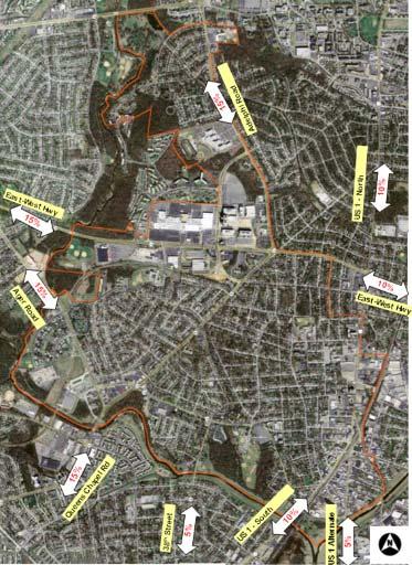
17 External Development and Regional Growth Cafritz Property Town of Riverdale Fort Totten Redevelopment Wasington D.C. (the Dakotas, Cafritz) University of Maryland East Campus Greenbelt Metro Station TOD Mt. Rainer Town Center Major roadways (US 1, MD 410, MD 500, MD 208, US 1 Alt) are sensitive to regional growth in existing through traffic volumes Average 20% to 30% increase in through traffic on US 1, US 1 Alt, MD 500, MD 410 and MD 208 (growth rate provided by SHA Travel Forecasting Division)
18 Estimating Future Traffic Year 2035 is the study horizon year to be consistent with State and Regional Planning Models Total Potential Build-out within City of Hyattsville 250,000 SF Retail 25% of total new traffic 525,000 SF Office 30% of total new traffic 5,000 Residential units 45% of total new traffic 500 vehicle trips per peak hour by individual land use= 1,500 residential units 400,000 SF Office Building 100,000 SF Retail Source Institute of Transportation Engineers Trip Generation Handbook, 8 th Edition and M-NCPPC
19 Estimating Future Traffic Total New Peak Hour Vehicle Trips Forecasted in Hyattsville by Major Development West Hyattsville Commons* 940 AM, 1224 PM EYA 254 AM, 428 PM Belcrest Center/ Landy 1376 AM,1846 PM University Town Center** 70 AM, 235 PM WSSC Building 153 AM, 142 PM GRAND TOTAL 2,800 AM, 3,875 PM*** * Based on 2008 West Hyattsville Commons Traffic Impact Study, does not include maximum buildout of 3,600 residential units and 1,000,000 SF office/ commercial **New Hotel at East-West and Belcrest ***Includes new County Elementary School on Nicholson Street with access via Editors Park Drive and 26 Single Family homes north of St. Marks Church on Adelphi Road
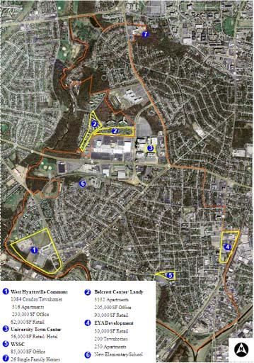
20 Development Locations
21 Distribution of Traffic
22 Existing Level of Service
23 Future No Improvements Level of Service
24 Approach to Developing Improvements Sensitive to limited capital budgets Integrated, comprehensive, systems-level multi-modal focus Focus on other modes first Safety improvements for pedestrians (signal timing, curb and median extensions) Bicycle connections (lanes, trails, cycle tracks) Transit enhancements (e.g. bus shelters) Transportation Demand Management and Parking Maximize efficiency of existing curb-to-curb width Lane configuration/ turn lanes Parking restrictions New traffic signals or roundabouts Optimized signal phasing and timing Access controls Roadway extensions to complete grid
25 One-Way vs. Two-Way Traffic Flow and a Grid Network Current best practice is to maximize use of grid street network over one-way circulation or cul-de-sac Improvements to State routes, and improving access to State routes, will be a focus to keep traffic out of neighborhood streets One-way streets maximize traffic flow and speed, which is not a goal for a residential street One-way streets create additional travel to reach destination Two-way streets diffuse overall traffic volume and speed Two-way streets conform with driver, pedestrian and bicyclist expectancy Two-way streets provide most direct access Recommendations do not preclude following City s Traffic Calming request protocol for chicanes, chokers, etc.

 Install Speed Cameras to increase compliance with posted speed limits in school zones along: -US 1 (St. Jerome s, Hyattsville Elem.")
26 Short-Term Recommendations 1) Develop and Implement a Safe Route to School for Hyattsville Elementary to enhance safety for parents and children walking to school. Specific recommendations will be included for four major high-priority pedestrian corridors and three major high-priority bicycle corridors as noted in the 2008 Pedestrian and Bicycle Master Plan 42nd Avenue, 41st Avenue, Nicholson Street and Jefferson Street. NOW UNDERWAY! 2) Install Speed Cameras to increase compliance with posted speed limits in school zones along: -US 1 (St. Jerome s, Hyattsville Elem., DeMatha) -MD 410 (Nicholas Orem, Concordia) -42nd Avenue (Hyattsville Middle) -Adelphi Rd (Northwestern High) and -Ager Road at Nicholson (Rosa Parks Elem.)
27 Short-Term Recommendations 3) Install New Bicycle/ Pedestrian-Actuated Traffic Signals at Northwest Branch Trail crossings, pending results of SHA traffic study, to enhance major pedestrian/ bicycle trail crossings MD 208/ 38th Avenue south of Gaines Alley MD 500/ Queens Chapel south of Jamestown Road 4) Install new sidewalks along 38th Avenue between Hamilton and 38th Avenue Park/ City line and missing links along Hamilton Street between 38th Avenue and Queens Chapel to improve pedestrian access and safety. Include bicycle lane markings as part of the sidewalk improvements. 38 th Avenue project to be constructed spring and summer 2010

 Work with SHA to")

28 Short-Term Recommendations 5) Work with WMATA and County to upgrade high-volume bus stops with benches and shelters along the following major bus corridors: Hamilton St/ 38th Avenue to improve access to transit East-West Highway at Toledo Terrace 6) Work with SHA to finalize design of Queens Chapel Road streetscaping (median) project to identify final access controls between Belcrest Road and Hamilton Street.
29 Short-Term Recommendations 7) Work with SHA to review signal phasing and signal timing adjustments at the following locations Queens Chapel Road at Queensbury Road/ Belcrest Road US 1 from US 1 Alternate to East-West Highway 8) Lift access restrictions during the AM peak hours to improve traffic flow Eastbound Queensbury Road Oliver Street west of 43rd Avenue 9) Install access restrictions (No Left or Right Turns) along Lancer Drive east of Queens Chapel to discourage cut-through traffic
30 Short-Term Recommendations 10) Improve key pedestrian crossings of major arterials Adelphi Road at Wells Parkway (County Intersection) Ager Road at Nicholson Street East-West Highway at Queens Chapel Road (SHA) Queens Chapel Road at Queensbury Road (SHA) 11) Begin long-term planning with Univ. Park, Mt. Rainer, WMATA, etc. for a public, private or jointly operated circulator bus service to connect major activity centers such as EYA, UTC, Hamilton Street, West Hyattsville Metro and Prince George s Plaza Metro 12) Develop proposed cross-sections, signing and marking for implementation of key bicycle corridor connections (shared lanes, painted lanes, shoulder use, etc.) Adelphi Rd and 40th St/ Sheridan St (University Park) Rhode Island Avenue Trolley Trail (US 1) Ager Road Queens Chapel Rd and/ or Jamestown Rd
31 Long-Term Recommendations 1) Intersection Improvements a) Toledo Terrace at Belcrest - realign east leg of Toledo Road, extend America Blvd as part of Belcrest Center development, implement left-turn phasing b) Queens Chapel at Belcrest/ Queensbury - Restrict all left-turns EB-WB - Provide 2 nd NB left, 2 nd EB Right c) Ager Road and Lancer Dr Install New Traffic Signal d) Ager Road at Nicholson St Install New Traffic Signal e) Extend Hamilton Street to Chillum Road f) Queens Chapel at Nicholson Street Install New Traffic Signal (as part of SHA streetscape improvemnts) g) Queens Chapel Road from Chillum to Ager - re-stripe for 3 rd NB through lane h) Belcrest Road at Adelphi Road provide SB right-turn lane from Van Buren Street to Belcrest i) US 1 Alternate at Armentrout Drive - install roundabout control
32 Long-Term Recommendations 1) Intersection Improvements continued j) MD 410 at MD implement SHA planned 3 rd WB through lane - convert EB right to 3 rd EB through/ right lane - provide 2 nd NB right-turn lane under signal control k) US 1 at MD 410 (SHA/ Riverdale Park) - implement reversible lane to provide 3 rd EB through lane over CSX - new signal at MD 410/ 44 th Place, create quadrant intersection to divert EB and WB left-turns and NB left-turns from US 1/ MD 410 l) MD 410 at Toledo Terrace - widen to provide SB right turn lane - revise EB lanes to provide right-through, through and double left-turn
33 Long-Term Recommendations 2) Parking and Transportation Demand Management Strong need to manage future trips goal = 20% additional trips managed - Shift trips to another mode - Shift trips to another time (outside of peak hour) - Shift trips to another route - Trips not made Over 7,750 projected parking space demand at current zoning levels with TDOZ buildout. Municipal and/ or WMATA owned parking garage with shared parking, car shares, and parking fee surcharges to support jointly operated circulator shuttle Create a Transportation Management Association with City, County, Hyattsville Business and Professional Association and developers to manage TDM programs (transit passes, car shares, bicycle rentals, etc.) and monitor progress
34 Preliminary Cost Estimates Improvement Priority Funding Partners Cost Range Safe Routes to School Hyattsville Elementary Pedestrian and Bicycle Corridors Short-Term State and Federal Grants, City funds $250,000 (TBD in further study) Speed Cameras on US 1, 42 nd, Ager and MD 410 Short-Term City and Vendor New Signals at NW Branch Trail Crossing Short-Term City and State $150,000 each New Sidewalks along 38 th Avenue and Hamilton Street (including drainage improvements) Short-Term City $150,000 Upgrade bus stops with benches and shelters Short-Term City and WMATA $50,000 each Queens Chapel Road Streetscape Long-Term City and SHA $500,000 design and $7,000,000 construction Signing and Pavement Marking Upgrades (Access Restrictions) Pedestrian Crossing Improvements (new x-walks, ADA ramps, median, curb extensions) Short-Term City $50,000 Short-Term City and County $100,000 each Circulator Shuttle Service Long-Term County, WMATA, Private Developers $500,000 capital and $750,000 annual operating Bicycle Corridor Implementations (minor geometry, signing, marking) Short-Term City and County $50,000 per corridor including sign fabrication Intersection Improvement major geometry Long-Term City and Private Developers $2,500,000 each Upgraded or New Traffic Signals Short-Term City and Private Developers $150,000 each

35 Future No Improvements Level of Service

36 Future Level of Service with Improvements
37 Next Steps Concept plans and cost estimates for preferred alternatives Coordination with stakeholder agencies Safe Routes to School Study Final Report

38 Questions and Next Steps
Proposed Transportation Network
 Proposed Transportation Network Goals and Vision This Plan includes goals, policies, and strategies that can be used to shape public and private transportation initiatives for the next decade. Throughout
HYATTSVILLE TRANSPORTATION PLAN. City Council Update March 19, 2018
 HYATTSVILLE TRANSPORTATION PLAN City Council Update March 19, 2018 AGENDA PROJECT GOALS DATA COLLECTION WHAT WE LEARNED NEXT STEPS PROJECT GOALS Identify bicycle and pedestrian needs of the city Evaluate
City of Hyattsville Transportation Study Project Recommendations Planning Level Cost Estimate
 City of Hyattsville Transportation Study Project Recommendations Planning Level Cost Estimate Project ID Project Category Project Name Qty/Len(Mi) Cost Estimate BB 1 Bike boulevard Jefferson Street or
Agenda. Overview PRINCE GEORGE S PLAZA METRO AREA PEDESTRIAN PLAN
 PRINCE GEORGE S PLAZA METRO AREA PEDESTRIAN PLAN May 28, 2008 Agenda Welcome and introductions Project overview and issue identification Planning context and strengths Design challenges and initial recommendations
City of Wayzata Comprehensive Plan 2030 Transportation Chapter: Appendix A
 A1. Functional Classification Table A-1 illustrates the Metropolitan Council s detailed criteria established for the functional classification of roadways within the Twin Cities Metropolitan Area. Table
PRINCE GEORGE S PLAZA METRO AREA PEDESTRIAN PLAN
 PRINCE GEORGE S PLAZA METRO AREA PEDESTRIAN PLAN May 28, 2008 Agenda Welcome and introductions Project overview and issue identification Planning context and strengths Design challenges and initial recommendations
CITY OF BLOOMINGTON COMPLETE STREETS POLICY
 CITY OF BLOOMINGTON COMPLETE STREETS POLICY POLICY OBJECTIVE: The City of Bloomington will enhance safety, mobility, accessibility and convenience for transportation network users of all ages and abilities,
CITY OF COCOA BEACH 2025 COMPREHENSIVE PLAN. Section VIII Mobility Element Goals, Objectives, and Policies
 CITY OF COCOA BEACH 2025 COMPREHENSIVE PLAN Section VIII Mobility Element Goals, Objectives, and Policies Adopted August 6, 2015 by Ordinance No. 1591 VIII MOBILITY ELEMENT Table of Contents Page Number
Bus Rapid Transit Plans
 Twin Cities Region Bus Rapid Transit Plans ULI Minnesota Workshop Connecting Bus Rapid Transit to the Community December 15, 2009 John Levin Director of Service Development Metro Transit Metropolitan Area
Chapter 6 Transportation Plan
 Chapter 6 Transportation Plan Transportation Plan Introduction Chapter 6 Transportation Plan Transportation Plan Introduction This chapter describes the components of Arvada s transportation system, comprised
TRANSPORTATION & MOBILITY
 TRANSPORTATION & MOBILITY ROADWAY SYSTEM There are approximately 40 miles of roadways in Manitou Springs. For planning purposes, roadways are typically assigned a functional classification which defines
Solana Beach Comprehensive Active Transportation Strategy (CATS)
") Solana Beach Comprehensive Active Transportation Strategy (CATS) 3.0 Goals & Policies The Solana Beach CATS goals and objectives outlined below were largely drawn from the Solana Beach Circulation Element
Solana Beach Comprehensive Active Transportation Strategy (CATS) 3.0 Goals & Policies The Solana Beach CATS goals and objectives outlined below were largely drawn from the Solana Beach Circulation Element
Bluffdale/ UDOT South High-T Intersection Project Type Operations
 Bluffdale/ UDOT 14600 South High-T Intersection Project Type Operations 14600 South and Redwood Road $ 600,000 $ 550,000 This project is to install a new High-T intersection at Redwood Road and 14600 South
Sixth Line Development - Transit Facilities Plan
 Memorandum Date: November 13, 2012 To: From: c.c. Subject: Rob Freeman (Freeman Planning) Kevin Phillips Sixth Line Development - Transit Facilities Plan 33016631 This memo was prepared to review the transit
Classification Criteria
 SCHEDULE D TO RECOMMENDED OFFICIAL PLAN AMENDMENT NO. 40 SCHEDULE C-4 Road Criteria Criteria Traffic Service Objective Land Service/Access Typical Daily Traffic Volume Flow characteristics Travel Speed
Clackamas County Comprehensive Plan
 ROADWAYS The County s road system permits the movement of goods and people between communities and regions, using any of a variety of modes of travel. Roads provide access to virtually all property. They
Proposed White Flint Separated Bike Lane Network September 2015
 Proposed White Flint Separated Bike Lane Network September 2015 Abstract This report includes a proposed separated bike lane network for the White Flint Sector Plan area. Separated bike lanes create a
Preliminary Transportation Analysis
 Preliminary Transportation Analysis Goals of a Robust, Multimodal Transportation Network Safe Accessible/Connected Efficient Comfortable Context-Sensitive Motor Vehicle: Continue to analyze the data to
Omaha s Complete Streets Policy
 Omaha s Complete Streets Policy (Adopted August 2015) VISION To create great places and enhance our quality of life, the City of Omaha will provide safe, accessible streets for all users. Complete Streets
CONNECTING PEOPLE TO PLACES
 CONNECTING PEOPLE TO PLACES 82 EAST BENCH MASTER PLAN 07 Introduction The East Bench transportation system is a collection of slow moving, treelined residential streets and major arteries that are the
Chapter 5 Future Transportation
 Chapter 5 Future Transportation The Future Land Use Plan identifies the desired land use designations. The land uses desired for Crozet depend, in large part, on the success of the transportation system,
BETHEL ROAD AND SEDGWICK ROAD CORRIDOR STUDY
 DRAFT PLAN City Council Meeting August 14, 2017 STUDY AREA Sedgwick Corridor State Route 160, principal arterial with Class 3 access management designation, commuter and freight route, connection to SR
West Dimond Blvd Upgrade Jodhpur Street to Sand Lake Road
 West Dimond Blvd Jodhpur St to Sand Lake CSS Transportation Project Summary Municipality of Anchorage Project # 05 005 Project Manager: John Smith, P.E. (MOA PM&E) Project Administrator: Julie Makela,
Princeton Avenue and Spruce Street Transportation and Site Access Enhancements Project
 Princeton Avenue and Spruce Street Transportation and Site Access Enhancements Project Mercer County Planning Division AECOM Transportation (formerly DMJM Harris) January 29, 2009 Agenda Project Status
Proposed. City of Grand Junction Complete Streets Policy. Exhibit 10
 Proposed City of Grand Junction Complete Streets Policy Exhibit 10 1 City of Grand Junction Complete Streets Policy Vision: The Complete Streets Vision is to develop a safe, efficient, and reliable travel
II. Identification of Opportunities and Solutions. A. Short-term action plan (Summary of Recommendations)
") II. Identification of Opportunities and Solutions Upon completion of the planning process for this report, a wide range of recommendations were developed throughout the City. The list of proposed recommendations
II. Identification of Opportunities and Solutions Upon completion of the planning process for this report, a wide range of recommendations were developed throughout the City. The list of proposed recommendations
Downtown Naples Mobility and Connectivity Study. Naples City Council Presentation January 2017
 Downtown Naples Mobility and Connectivity Study Naples City Council Presentation January 2017 Agenda 1. Introduction 2. Scope Review 3. Project Schedule 4. Existing Conditions 5. Public Charrette 6. Mobility
TRANSPORTATION TRAINING TOPICS. April 6, 2010
 TRANSPORTATION TRAINING TOPICS April 6, 2010 Roles of Transportation Providers Context and Policy Makers Division of Transportation and Traffic Other City Operations Other Transportation Operators CMA
TRANSPORTATION AND CIRCULATION
 TRANSPORTATION AND CIRCULATION The plan reinforces the City of College Park s vision for US 1 becoming a revitalized gateway boulevard. Emphasis has been placed on the pedestrian quality of a new streetscape
List of Exhibits...ii
 One Brickell Traffic Study TABLE OF CONTENTS List of Exhibits...ii EXECUTIVE SUMMARY...1 1. INTRODUCTION...2 1.1 Study Area...2 1.2 Study Objective...5 2. EXISTING TRAFFIC CONDITIONS...6 2.1 Data Collection...6
Prince George s County plans, policies, and projects
 Prince George s County plans, policies, and projects Over 250 projects for trails, bikeways, designated bike lanes and sidewalk construction Trail projects that improve access to Metro Sidewalk and trail
Bicycle and Pedestrian Master Plan
 City of Hyattsville, Maryland Bicycle and Pedestrian Master Plan March 2008 Committee Members Nathaniel Kelso, Matt McKnight, Anne Villacres, Cynthia Way, Alicia Wilson Aimee Condayan, Lisa Grob, Jim Groves,
WELCOME TO OPEN HOUSE # 1 June 14, 2017
 Langstaff Road Weston Road to Highway 7 Class Environmental Assessment Study WELCOME TO OPEN HOUSE # 1 June 14, 2017 Please sign in and join our mailing list Purpose of Open House #1 & Study Area York
Exhibit 1 PLANNING COMMISSION AGENDA ITEM
 Exhibit 1 PLANNING COMMISSION AGENDA ITEM Project Name: Grand Junction Circulation Plan Grand Junction Complete Streets Policy Applicant: City of Grand Junction Representative: David Thornton Address:
Prince George s County Council Retreat January 5, 2017
 Rushern L. Baker, III County Executive Darrell B. Mobley Director Prince George s County Council Retreat January 5, 2017 DPW&T STRUCTURE AND SERVICES Office of Transportation: Fixed route transit service
Welcome to the Quebec Alternatives Analysis Public Meeting
 Welcome to the Public Meeting Please sign in. Public Comment Please fill out a comment card and tell us what you think. Check back or comment any time at: www.quebecalternatives.com Project Area Technical
Vision: Traditional hamlet with an attractive business/pedestrian friendly main street connected to adjacent walkable neighborhoods
 N D. Focus Area II Vision: Traditional hamlet with an attractive business/pedestrian friendly main street connected to adjacent walkable neighborhoods Transit Road Focus Area II is located in the Hamlet
Planning Study SR 976. Project Advisory Team Meeting May 24, 2017
 ` SR 976 BIRD ROAD/SW 40TH STREET FROM SR 821/HEFT TO SR 5/US-1 Miami-Dade County, Florida FPID No.: 434845-4-22-01 Planning Study Project Advisory Team Meeting May 24, 2017 1 Agenda Introductions Project
SECTION 1 - TRAFFIC PLANNING
 SECTION 1 - TRAFFIC PLANNING 1.1 TRAFFIC OPERATIONS 1.1.1 Roadway Functional Classification The Multnomah County Comprehensive Framework Plan s Policy 34: Trafficways and the Functional Classification
TRASBURG RANSPORTATION
 TRASBURG RANSPORTATION LAN DEVELOPED BY THE TRANSPORTATION PLANNING DIVISION OF THE VIRGINIA DEPARTMENT OF TRANSPORTATION IN COOPERATION WITH THE U.S. DEPARTMENT OF TRANSPORTATION, FEDERAL HIGHWAY ADMINISTRATION
TRANSPORTATION IMPROVEMENT STRATEGY
 TRANSPORTATION IMPROVEMENT STRATEGY A Vision for Staten Island North Shore November 2016 1 EXISTING CONDITIONS Transit Conditions MTA Bus Staten Island Railroad Peak Directional Traffic Volume (per hour)**:
MONTGOMERY COUNTY PLANNING DEPARTMENT THE MARYLAND-NATIONAL CAPITAL PARK AND PLANNING COMMISSION
 MONTGOMERY COUNTY PLANNING DEPARTMENT THE MARYLAND-NATIONAL CAPITAL PARK AND PLANNING COMMISSION MCPB Item No. 5 Date: 12/3/15 Draft White Flint Separated Bike Lanes Network David Anspacher, Functional
North Avenue Corridor Study
 North Avenue Corridor Study City Council October 6, 2014 Presentation Outline Project Initiation & Process Corridor Conditions & Issues Vision & Goals Concept Development - Development/Evaluation Implementation
Washington DC Section of ITE Project Briefing
 Washington DC Section of ITE Project Briefing November 5, 2015 Renée Hamilton, VDOT, Deputy District Administrator I-66 Outside the Beltway Improvement Area Project Location Virginia 2 Purpose and Need
Summary: Mercer County Princeton Avenue & Spruce Street Study January 2009
 Summary: Several recent studies have assessed potential development and redevelopment opportunities in the Mercer Crossing area of Trenton, Ewing, and Lawrence. This Princeton Avenue and Spruce Street
Outreach Approach RENEW SF served as the primary liaison with the North Beach community; the Chinatown. Executive Summary
 Executive Summary Executive Summary The Columbus Avenue Neighborhood Transportation Study s objective is to identify changes to transportation infrastructure and policies that could enhance the livability
Welcome. The Brooklin Secondary Plan and Transportation Master Plan are collectively referred to as the Brooklin Study.
 Welcome The Town of Whitby is undertaking a study to prepare a Secondary Plan and Transportation Master Plan to guide and manage growth in the Brooklin area. The Brooklin Secondary Plan and Transportation
Moving Cambridge. City of Cambridge Transportation Master Plan Public Consultation Centre. March 7, :00 8:00 PM.
 City of Cambridge Transportation Master Plan Public Consultation Centre March 7, 2018 5:00 8:00 PM Region of Waterloo City of Cambridge Transportation Master Plan Public Consultation Centre March 7, 2018
Item to be Addressed Checklist Consideration YES NO N/A Required Description Complete Streets Guidelines
 Passaic County Complete Streets Checklist - Concept Development Project Name Item to be Addressed Checklist Consideration YES NO N/A Required Description Complete Streets Guidelines Existing Plans Have
Town of Bethlehem. Planning Assessment. Bethlehem Town Board
 Town of Bethlehem US 9W Corridor Transportation Planning Assessment Presented e to: Bethlehem Town Board June 2009 Overview Study Background Route 9W Corridor Conditions and Improvements Selkirk Bypass
Southwest Bus Rapid Transit (SW BRT) Functional Planning Study - Executive Summary January 19 LPT ATTACHMENT 2.
 Functional Planning Study - Executive Summary January 19 LPT ATTACHMENT 2.") Southwest Bus Rapid Transit (SW BRT) Functional Planning Study - Executive Summary 2011 January 19 1 of 19 Introduction This executive summary presents the results of the Southwest Bus Rapid Transit (SW
Southwest Bus Rapid Transit (SW BRT) Functional Planning Study - Executive Summary 2011 January 19 1 of 19 Introduction This executive summary presents the results of the Southwest Bus Rapid Transit (SW
Complete Streets in Constrained Corridors: Chicago s Central Loop BRT
 Complete Streets in Constrained Corridors: Chicago s Central Loop BRT NACTO Designing Cities Conference October 24, 2012 Luann Hamilton, Deputy Commissioner What is BRT? Bus-based system that improves
PenPlace SPRC #6. September 27, DRAFT
 PenPlace SPRC #6 1 Agenda Site and Project Overview Multiple Transportation Options Traffic Analysis Neighborhood Analysis Street Network Street Sections/Sidewalk Width Pedestrian/Bicycle Circulation Secure
North Shore Transportation Improvement Strategy
 North Shore Transportation Improvement Strategy Preliminary, Near-term Recommendation 2016 April Transportation Improvement Strategy (TIS) Comprehensive and Analytical A multi-modal transportation strategy
Dr. M.L. King, Jr. Street North Complete Streets Resurfacing Opportunities HOUSING, LAND USE, AND TRANSPORTATION COMMITTEE MARCH 22, 2018
 Dr. M.L. King, Jr. Street North Complete Streets Resurfacing Opportunities HOUSING, LAND USE, AND TRANSPORTATION COMMITTEE MARCH 22, 2018 What s Happening The City plans to mill and resurface Dr. M.L.
This chapter describes the proposed circulation system and transportation alternatives associated with
 5.0 Circulation 5.1 OVERVIEW This chapter describes the proposed circulation system and transportation alternatives associated with West Landing, and summarize the information contained in the Existing
5858 N COLLEGE, LLC N College Avenue Traffic Impact Study
 5858 N COLLEGE, LLC nue Traffic Impact Study August 22, 2016 Contents Traffic Impact Study Page Preparer Qualifications... 1 Introduction... 2 Existing Roadway Conditions... 5 Existing Traffic Conditions...
2016 Church Street Access Study. 100 Clinton Square 126 North Salina Street, Suite 100 Syracuse, NY
 2016 Church Street Access Study 100 Clinton Square 126 North Salina Street, Suite 100 Syracuse, NY 13202 www.smtcmpo.org Syracuse Metropolitan Transportation Council Final Report February 23, 2016 This
APPENDIX 2 LAKESHORE ROAD TRANSPORTATION REVIEW STUDY EXECUTIVE SUMMARY
 APPENDIX 2 LAKESHORE ROAD TRANSPORTATION REVIEW STUDY EXECUTIVE SUMMARY Appendix 2 City of Mississauga Lakeshore Road FINAL REPORT Transportation Review Study December 2010 EXECUTIVE SUMMARY Study Purpose
Goodlettsville Bicycle and Pedestrian Plan Executive Summary
 Goodlettsville Bicycle and Pedestrian Plan July 2010 In Cooperation with the Nashville Area Metropolitan Planning Executive Organization Summary Introduction Progressive and forward thinking communities
Waterford Lakes Small Area Study
 Waterford Lakes Small Area Study Existing Traffic Conditions PREPARED FOR: ORANGE COUNTY PUBLIC WORKS DEPARTMENT TRAFFIC ENGINEERING DIVISION ORLANDO, FLORIDA PREPARED WITH: INWOOD CONSULTING ENGINEERS
TRAFFIC IMPACT STUDY COMPREHENSIVE UPDATE TOWN OF THOMPSON S STATION, TENNESSEE PREPARED FOR: THE TOWN OF THOMPSON S STATION
 TRAFFIC IMPACT STUDY COMPREHENSIVE UPDATE TOWN OF THOMPSON S STATION, TENNESSEE PREPARED FOR: THE TOWN OF THOMPSON S STATION Transportation Consultants, LLC 1101 17 TH AVENUE SOUTH NASHVILLE, TN 37212
4. ENVIRONMENTAL IMPACT ANALYSIS 9. TRANSPORTATION AND TRAFFIC
 4. ENVIRONMENTAL IMPACT ANALYSIS 9. TRANSPORTATION AND TRAFFIC 4.9.1 INTRODUCTION The following section addresses the Proposed Project s impact on transportation and traffic based on the Traffic Study
This page intentionally left blank.
 This page intentionally left blank. COMMUNITY Coweta Community Overview Coweta Coweta, a residential community located in Wagoner County, is a suburb of Tulsa situated southeast of the metropolitan area
Front and Myrtle Improvement Project
 Front and Myrtle Improvement Project MAKING BOISE THE MOST LIVABLE CITY IN THE COUNTRY DOWNTOWN: Our unique and vibrant urban neighborhood GUIDING PRINCIPLES: Innovation Celebration Transportation Downtown
NJDOT Complete Streets Checklist
 Background The New Jersey Department of Transportation s Complete Streets Policy promotes a comprehensive, integrated, connected multi-modal network by providing connections to bicycling and walking trip
Safe Streets. City of Lake Forest Park. March 21, 2017
 Safe Streets City of Lake Forest Park March 21, 2017 1 01 WELCOME 2 Agenda WELCOME WHAT IS THIS PROJECT? CONTEXT DRAFT CITYWIDE PROJECTS EXERCISE INTRODUCTION 3 02 WHAT IS THIS PROJECT? 4 WHAT IS THIS
COWETA HIGH SCHOOL AND EAST HIGHWAY 51
 COWETA HIGH SCHOOL AND EAST HIGHWAY 51 Lack of sidewalks along Ben Lumpkin Rd. Lack of crosswalks and ramps at intersection. Hwy 51 is wide to cross as a pedestrian. No ADA compliance or connection to
Arlington Public Schools New Elementary School at Thomas Jefferson Site Off-Site Transportation. Thomas Jefferson BLPC / PFRC Meeting July 27, 2016
 Arlington Public Schools New Elementary School at Thomas Jefferson Site Off-Site Transportation Thomas Jefferson BLPC / PFRC Meeting July 27, 2016 1.Review of Analysis 2.Key Transportation Issues 3.Recommendations
Public Meeting #1 January 30, 2018
 Public Meeting #1 January 30, 2018 Meeting Outline Mayor s Introduction Presentation Q&A Group Activities Wrap-up Presentation Outline Introduction Existing Conditions Market Assessment Break-out Setup
Huntington Station Metro Zone / North Kings Highway Concept Plan
 Summary Narrative of Huntington Station Metro Zone / North Kings Highway Concept Plan Located in Fairfax County, Virginia prepared for A.J. Dwoskin & Associates, Inc.. 9302 Lee Highway, Suite 300 Fairfax,
Ownership Lots 17 & 18 (Part of Lot 14), Montgomery Auto Sales Park
, Montgomery Auto Sales Park") Traffic Impact Analysis Ownership Lots 17 & 18 (Part of Lot 14), Montgomery Auto Sales Park Silver Spring, MD Lot 17: Site Plan No. 821413 Lot 18: Site Plan No. 821414 Filing Number: 13-TS-1198527A Prepared
Traffic Impact Analysis Ownership Lots 17 & 18 (Part of Lot 14), Montgomery Auto Sales Park Silver Spring, MD Lot 17: Site Plan No. 821413 Lot 18: Site Plan No. 821414 Filing Number: 13-TS-1198527A Prepared
Third Street Bridge & Corridor Project
 Third Street Bridge & Corridor Project Preparation for the FY2018 budget to commence October 1, 2017, includes funding to address a project that has been considered since 1994. The Third Street bridge
Roadway Classification Design Standards and Policies. Pueblo, Colorado November, 2004
 Roadway Classification Design Standards and Policies Pueblo, Colorado November, 2004 Table of Contents Page Chapter 1. General Provisions 1.1 Jurisdiction 3 1.2 Purpose and Intent 3 1.3 Modification 3
Memorandum. Sunday, July 13, Saturday, July 19, 2014
 Memorandum To: David Lowin, Brooklyn Bridge Park Corporation From: Daniel Schack, AICP, PTP Date: Re: Brooklyn Bridge Park Pier 5/6 Loop Road Traffic Study Project No: 14-01-2407 At the request of Brooklyn
Transportation Corridor Studies: Summary of Recommendations
 Transportation Corridor Studies: Summary of Recommendations Route 4 Corridor Study: Route 10 Corridor Study: Route 44 Corridor Study: Route 175 Corridor Study: Route 5/15 Corridor Study: Rentschler Field
Corridor Advisory Group and Task Force Meeting #10. July 27, 2011
 Corridor Advisory Group and Task Force Meeting #10 July 27, 2011 1 Agenda Recap CAG/TF #9 Public Meeting #2 Summary Single Mode Alternatives Evaluation Results Next Steps 2 3 CAG/TF #9 Recap CAG /TF #9
7/23/2017 VIA . Michael Hanebutt City of Sacramento Community Development Department 300 Richards Boulevard, 3 rd Floor Sacramento, CA 95811
 7/23/2017 VIA EMAIL Michael Hanebutt City of Sacramento Community Development Department 300 Richards Boulevard, 3 rd Floor Sacramento, CA 95811 RE: 65 th Street Apartments (DR17-220) Dear Mr. Hanebutt:
COMPLETE STREETS PLANNER S PORTFOLIO
 COMPLETE STREETS PLANNER S PORTFOLIO ISSUE 3 APRIL 2016 PLANNER S PORTFOLIO COMPLETE STREETS 1 2 6 10 14 OVERVIEW MATURE NEIGHBORHOODS GROWING SUBURBS CENTRAL PLACES ACTIVITY CORRIDORS Planner s Portfolio
Environment and Public Works Committee Presentation
 Mixed Use Centers Complete Streets Guidelines Project Environment and Public Works Committee Presentation December 10, 2008 Project Objectives: Conduct an inter-departmental and agency process to study
Report. Typical Sections. City of Middleton, WI
 Report Typical Sections City of Middleton, WI December 2006 Report for City of Middleton, Wisconsin Typical Sections repared by: Traffic Associates LLC and STRAND ASSOCIATES, INC. 910 West Wingra Drive
OTTAWA TRAIN YARDS PHASE 3 DEVELOPMENT CITY OF OTTAWA TRANSPORTATION IMPACT STUDY. Prepared for:
 OTTAWA TRAIN YARDS PHASE 3 DEVELOPMENT CITY OF OTTAWA TRANSPORTATION IMPACT STUDY Prepared for: The Ottawa Train Yards Inc. 223 Colonnade Road South, Suite 212 Nepean, Ontario K2E 7K3 January 17, 2012
GOAL 2A: ESTABLISH AND MAINTAIN A SAFE, CONVENIENT, AND EFFICIENT MULTI-MODAL TRANSPORTATION SYSTEM TO MOVE PEOPLE AND GOODS THROUGHOUT THE CITY.
 2. TRANSPORTATION ELEMENT The purpose of this element is to assist in establishing an adequate transportation system within the City and to plan for future motorized and non-motorized traffic circulation
Mineral Avenue Corridor Assessment. ITE 2017 Western District Annual Meeting San Diego, CA June 21 st
 Mineral Avenue Corridor Assessment ITE 2017 Western District Annual Meeting San Diego, CA June 21 st Biography - Aaron Heumann, PE, PTOE Currently City of Littleton Transportation Engineering Manager 24
Paoli Road Improvement Feasibility Study
 Paoli Road Improvement Feasibility Study & Public Participation Project March 24, 2015 Prepared for: Tredyffrin Township Prepared by: McMahon Associates, Inc. with Town Planning Partnership, LLC Glackin
HIGHBURY AVENUE/HAMILTON ROAD INTERSECTION IMPROVEMENTS PUBLIC INFORMATION CENTRE 1 MAY 14, 2015
 HIGHBURY AVENUE/HAMILTON ROAD INTERSECTION IMPROVEMENTS Municipal Class Environmental Assessment PUBLIC INFORMATION CENTRE 1 MAY 14, 2015 ACCESSIBILITY Under the Accessibility Standards 2015 for Customer
HENDERSON DEVELOPMENT 213, 217, 221, 221 ½, 223 HENDERSON AVENUE and 65 TEMPLETON STREET OTTAWA, ONTARIO TRANSPORTATION OVERVIEW.
 HENDERSON DEVELOPMENT 213, 217, 221, 221 ½, 223 HENDERSON AVENUE and 65 TEMPLETON STREET OTTAWA, ONTARIO TRANSPORTATION OVERVIEW Prepared for: 2294170 Ontario Inc. February 2, 2017 117-652 Report_1.doc
MINERAL AVENUE CORRIDOR ASSESSMENT STUDY IMPLEMENTATION STRATEGY
 MINERAL AVENUE CORRIDOR ASSESSMENT STUDY IMPLEMENTATION STRATEGY INTRODUCTION City Personnel Sign-in Sheet Comment Forms Please Write Down Any Feedback INTRODUCTION List of Topics for Presentation Study
DULLES AREA TRANSPORTATION ASSOCIATION (DATA) February 18, Susan Shaw, P.E., VDOT, Megaprojects Director
 February 18, Susan Shaw, P.E., VDOT, Megaprojects Director") DULLES AREA TRANSPORTATION ASSOCIATION (DATA) February 18, 2015 Susan Shaw, P.E., VDOT, Megaprojects Director I-66 Corridor Conditions Steady population growth Employment growth in activity centers Congestion
DULLES AREA TRANSPORTATION ASSOCIATION (DATA) February 18, 2015 Susan Shaw, P.E., VDOT, Megaprojects Director I-66 Corridor Conditions Steady population growth Employment growth in activity centers Congestion
Perryville TOD and Greenway Plan
 Perryville TOD and Greenway Plan Greenway Glossary Pathway: A bicycle and pedestrian path separated from motorized vehicular traffic by an open space, barrier or curb. Multi-use paths may be within the
Land Use Bicycle Spaces Required Type Residential
 SAMPLE ORDINANCES AND RESOLUTIONS APPENDIX B SAMPLE BICYCLE PARKING ORDINANCE Land Use Bicycle Spaces Required Type Residential Single Family/Two Family N/A N/A Apartment/Townhome 1 per unit plus 6 space
2. TRANSPORTATION ELEMENT.
 2. TRANSPORTATION ELEMENT. The purpose of this element is to assist in establishing an adequate transportation system within the City and to plan for future motorized and non-motorized traffic circulation
S T A T I O N A R E A P L A N
 The Circulation and Access Plan describes vehicle, pedestrian, and transit improvements recommended within the Concept Plan. In order to create and sustain a vibrant business district that provides pedestrian-friendly
Gateway Transportation Study
 Gateway Transportation Study Amherst, Massachusetts SUBMITTED TO University of Massachusetts Amherst Town of Amherst SUBMITTED BY Vanasse Hangen Brustlin, Inc. Watertown, Massachusetts March 213 Back of
Tonight is for you. Learn everything you can. Share all your ideas.
 Strathcona Neighbourhood Renewal Draft Concept Design Tonight is for you. Learn everything you can. Share all your ideas. What is Neighbourhood Renewal? Creating a design with you for your neighbourhood.
TECHNICAL MEMORANDUM. Introduction
 TECHNICAL MEMORANDUM To: From: John M. Welsh Chris Furlong AHC, Inc. Andrew T. Smith, P.E. Edward Y. Papazian, P.E. Kimley-Horn and Associates, Inc. Date: July 6, 2017 Subject: 200 9 th reet South Redevelopment
14 TH STREET TRANSPORTATION & STREETSCAPE DESIGN STUDY PLAN B PLAN B TRANSPORTATION & STREETSCAPE RECOMMENDATIONS
 14 TH STREET TRANSPORTATION & STREETSCAPE DESIGN STUDY PLAN B PLAN B TRANSPORTATION & STREETSCAPE RECOMMENDATIONS 141 Symbols Recommendations - Southern End of 14th Street Study Area Streetscape Each icon
TRANSPORTATION and CIRCULATION
 Greenbelt Metro Area Sector Plan - Sector-Wide Vision and Recommendations - Transportation and Circulation 37 TRANSPORTATION and CIRCULATION OBJECTIVES The sector plan transportation and circulation recommendations
ALLEY 24 TRAFFIC STUDY
 ALLEY 24 TRAFFIC STUDY in City of Frostburg, Maryland January 2013 3566 Teays Valley Road Hurricane, WV Office: (304) 397-5508 www.denniscorporation.com Alley 24 Traffic Study January 2013 Frostburg, Maryland
CHAPTER 7 OF THE COMPREHENSIVE PLAN TRANSPORTATION Mobility for all Modes
 CHAPTER 7 OF THE COMPREHENSIVE PLAN TRANSPORTATION 2030 Adopted xxx, xx, xxxx Mobility for all Modes Chapter 7, Page 0, Draft version 48 Context and Vision Why Automobiles Alone are not the Answer Because