Complete Streets in Constrained Corridors: Chicago s Central Loop BRT
|
|
|
- Zoe Price
- 5 years ago
- Views:
Transcription
1 Complete Streets in Constrained Corridors: Chicago s Central Loop BRT NACTO Designing Cities Conference October 24, 2012 Luann Hamilton, Deputy Commissioner


2 What is BRT? Bus-based system that improves speed, reliability and passenger comfort Combines stations, vehicles, services, running ways and ITS into an integrated system Reliability of rail transit with flexibility of bus transit 2


3 Potential BRT Elements Exclusive Traffic Lanes Traffic Signal Priority Limited Stops Boarding Area Canopies Real Time Bus Arrival Signs Prepaid Boarding Streetscaping Wide Doors Bus Floor Level Boarding High Capacity Metrobus, Mexico City SBS New York City 3

4 First exclusive bus lane on Washington in 1939 BRT in Chicago Jeffery Blvd. peak hour dedicated lanes later in 2012 Central Loop BRT in 2014 Western/Ashland BRT alternatives study underway A role between rail and bus levels of service 4
5 Central Area Plan Transit Recommendations Increase CTA and Metra Rail and Bus Capacity into Downtown Provide improved transit distribution around downtown Improve intermodal connections including rail-torail and rail-to-bus Provide express rail service to the airports 5
6 Project Purpose Improve mobility in Central Area for residents, employees and businesses Provide faster, more reliable bus service Accommodate projected growth in trips Manage congestion Transit that is easy to use and understand Allow incremental improvements to service Build off of existing infrastructure Intermodal connections including rail-to-rail and rail-to-bus 6

 Branded,")

7 FTA-Funded Work Plan Bus Priority Lanes Tinted lanes on Madison, Washington, Canal, Clinton for six bus routes BRT Stations for level boarding Enhanced Enforceability and signal timing Union Station Transit Center Sheltered boarding platforms for at least 6 CTA routes Connects to existing pedwayunder Jackson (by Track 2) Branded, Enhanced Urban Circulator Bus Service Ogilvie & Union Stations to Navy Pier Video screens with Bus Tracker and other travel info Improvements for Pedestrians & Cyclists 7

8 Metra-Navy Pier Circulator Route 8
9 Buses, Bikes, Parking, Cars? Four elements compete for street space Separation of modes key to safety and efficiency Dedicated bus lanes Dedicated bike lanes, cycle tracks Buffer zones for parking Turn Lanes Loop is a 400 x 450 grid of one-way & two-way streets Shoehorn all competing elements on every street? Balance elements across the Loop as a whole?


10 Six Routes to Share Busway Combined service Michigan Ave to Ogilvie every 2-3 minutes during rush hour Currently stuck at 3-5mph 24-hour service on #20 & #60 Better service reliability en route to destinations citywide Also used by United Center Exp. and parts of other routes 10
11 E-W Loop Streets (existing) Randolph Washington Madison Monroe Adams Jackson Direction WB EB WB EB WB EB Width Travel& (Turn) Lanes 3(1) 3(1) 2(1) Bus Lanes 0 2.5/8 blocks 4.5/8 blocks 0 5/8 blocks 2.5/8 blocks Bike Lanes
 Monroe (east of Dearborn) LEFT Pay-to-Park (1 block):")
 LEFT Loading (4 cars): Bank of America")
 RIGHT Valet (1/2 block): Palmer House (btw State &")
 LEFT Pay-to-Park(1 block): Michigan to Wabash LEFT turn bay")
: W Hotel btw LaSalle & Wells (INSIDE BUS LANE) LEFT Free Off-Peak")
: 216 W Jackson (btw Franklin & Wells) LEFT Free Off-Peak Parking (1/3")
12 E-W Loop Streets (existing) Monroe (east of Franklin) Adams (west of Michigan) Jackson (west of Franklin) Monroe (east of Dearborn) LEFT Pay-to-Park (1 block): Franklin to Wells LEFT Off-Peak Loading: LaSalle to Clark RIGHT Valet (1 car): Italian Village (btw Clark & Dearborn) LEFT Loading (4 cars): Bank of America Theater (btw State & Dearborn) LEFT 15-Min. Standing (2 cars): 6 E. Monroe (btw State & Wabash) RIGHT Valet (1/2 block): Palmer House (btw State & Wabash) LEFT Valet (1/2 block): University Club (btw Wabash and Michigan Adams (west of Dearborn) LEFT Pay-to-Park(1 block): Michigan to Wabash LEFT turn bay (1 block): Dearborn to Clark LEFT Valet (4 cars): Club Quarters w/o Clark RIGHT Valet (4 cars): W Hotel btw LaSalle & Wells (INSIDE BUS LANE) LEFT Free Off-Peak Parking: LaSalle to Wells (old) Jackson (east of Wells) LEFT Handicapped (3 cars): 216 W Jackson (btw Franklin & Wells) LEFT Free Off-Peak Parking (1/3 block): e/o State (old) 12

13 Existing Bus & Bike Lanes 13
 No dedicated striping for bikes on Washington?")
14 E-W Loop Streets BUS BIKE CAR Primary EB BRT Route = Washington Primary WB BRT Route = Madison Existing bus lanes on Adams & Jackson remain Bike lane on Madison? Dedicated lanes or Cycle Track on Monroe? Dedicated lanes or Cycle Track on Adams & Jackson? (avoid ex. turn bays and parking/loading) No dedicated striping for bikes on Washington? What about Randolph? Minimum of 2 travel lanes for each roadway Consider turn restrictions case-by-case PARKING Consider Pay-to-Park relocations case by case 14
15 Design Concepts Developed 3 design concepts with varying degrees of separation between buses, bikes and regular traffic lanes: Option 1 -Basic Option 2 - Balanced Option 3 -Focused Final design may combine elements of different options 15


16 Option 1 -Basic On Washington & Madison: Bus Lane on right curb Left turns cross Bike Lane Right turns enter Bus Lane Queue Jump signals at selected intersections Protected Bike Lane on Washington, regular Bike Lane on Madison Example - Washington Example - Madison 16

17 Option 2 Balanced On Washington: Bus Lane adjacent to Bike Island Boarding Platforms Buffered from Auto Lanes 2-Thru Auto Lanes with Turn Lane Pockets Curbside Protected Bike Lane On Madison: Bus and Auto Lanes similar to existing Curb Extension Boarding Platforms 2-Thru Auto Lanes with Turn Lane Pockets Bike facilities relocated to Protected Bike Lane on Randolph Example - Washington Example - Madison 17
 Single, Intermittent Access Lane to Alleys and Garages Block-long Curb extensions for")

18 Option 3 -Focused Bi-directional Busway on Madison No Thru Vehicular Traffic (moves to Randolph & Adams) Single, Intermittent Access Lane to Alleys and Garages Block-long Curb extensions for Boarding Platforms and public open space Protected bike lanes on Washington and Randolph NOTE: Requires outside funding beyond current grant. Example - Madison Example Washington/Randolph 18
19 Evaluation of Options: Factors to consider Travel time savings of bus service Traffic Impacts Parking and Curb Use Impacts Benefits or Impacts for Pedestrians Capital Cost Ridership Stakeholder and civic acceptance 19

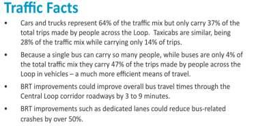
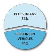
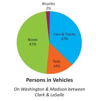
20 Traffic Stats 20
21 Total round-trip travel time benefit (slower) Travel Minutes Saved (faster) Net average user benefit (47% Bus; 51% Car/Taxi) Option 1: min Option 2: min Option 3: min 21
22 Benefits and Drawbacks Option 1 -Basic Benefits: Simplest to install, fewest impacts, within grant. Drawbacks: Fewest benefits to transit users Option 2 Balanced Benefits : Most cost-effective, looks like a real improvement without dramatic change to traffic; closest scope to current grant amount. Drawbacks : Greatest amount of curb use impacts to be resolved Option 3 Focused Benefits : Most like rail transit, best separation of bus from auto, creates new pedestrian and public space at corners Drawbacks : More expensive, disruptive to westbound motorists, requires additional outside funds beyond current grant 22

23 Selected: Option 2 Balanced 23

24 Stay In Touch Website Facebook facebook.com/cdotnews 24
25 NOTES 25
26 CTA BRT Preferences 1. Lane width requirements Preferred: 12 ; Minimum: Berthing, 13 Passing 2. Do not remove existing bus lane on Madison 3. Need to keep #20 Madison and #56 Milwaukee on Madison. May consider moving circulator and other routes to Randolph. 4. Washington must be the EB BRT Route 5. Either relocate existing bike lane on Madison to leftside of the street or remove it completely from the corridor. Providing better bike facility on parallel corridor could lessen the need to accommodate bikes specifically on Madison 6. No shared bus/bike lanes downtown (keep to separate, dedicated facilities) 7. Curbside/bumpoutboarding platforms preferred over median boarding 8. Must allow accommodations for buses to pass 9. Need enforcement of bus lanes. 9/27/ CDOT/CTA Coordination Meeting
27 Bike Preferences (CDOT) 1. Protected Bike Lanes (Cycle Track) Mayor s initiative for 100 miles of Cycle track in 4 years 11 preferred width (7 bike lane, 4 separation) 8 minimum width (5 bike lane, 3 separation) If parking is necessary, put cycle track between curb and parking If lane is to be on the left, it must be protected 2. Dedicated Striped Lane 6 preferred width 5 minimum width (assuming gutter does not interfere) Standard bike lane placement on right side of travel lanes No part-time bike lanes 3. Shared Bus & Bike Lane 21 preferred (12 bus, 6 bike, 3 separation) 4. General Bikes will go all the way to their final destination regardless of accommodations. Concentrating amenities on a specific corridor may have some effectiveness but will not pull all bikers away from parallel corridors Cycle tracks currently being considered on Randolph (WB), Des Plaines (SB), and Jefferson (NB) 9/27/ CDOT/CTA Coordination Meeting
28 Car Preferences (CDOT) 1. CDOT requirements are already a compromise AASHTO/IDOT preferred lane width 12 Typical minimum lane width 11 Minimum through lane width 10 (only allowed case-by case) Minimum turn lane width 9 (only when no other alternative!) Turn lanes need 10:1 tapers 2. Must provide access to alleys, driveways, and loading zones 3. Two travel lanes must be provided so blockages do not cripple the system 4. With current traffic volumes, 2 or 3 travel lanes are typically needed 9/27/ CDOT/CTA Coordination Meeting
29 Car Preferences (continued) 5. Left and Right turn bays Provide an area for cars to queue as pedestrians cross Allow through movements to pass - Length of turn bay designed to queues, with absolute min. length = 60 - Backups from turns spilling back into through lanes are a primary source of congestion Elimination of turns may: - Inconvenience businesses - Put additional burden on other turn movements 9/27/ CDOT/CTA Coordination Meeting
30 Curbside Preferences 1. General Dimensions 8 preferred width 7 minimum width 2. Pay-to-Park Spaces Leased by LAZ Contract requires removals or relocations to be compensated with revenue-neutral alternatives or cash reimbursement 3. Handicapped Spaces Residential Spaces paid for by applicant (set up plus annual fee) Requires Aldermanic approval to remove or relocate ADA compliance is a top priority 4. Loading Zones Set up and annual maintenance fee paid for by applicant. Requires Aldermanic approval to remove or relocate Loading zones can be critical to business operations (hotels) 9/27/ CDOT/CTA Coordination Meeting


31 Union Station Transit Center Recent DRAFT Layout Union Station Great Hall W. Jackson Blvd --> Elevator/stairs & pedway S. Clinton St. Amtrak Parking Garage (to remain) Alternative site Existing Amtrak pedway S. Canal St. --> 31


32 Union Station Transit Center Original concept design 32
Designing Streets for Transit. Presentation to NACTO Designing Cities Kevin O Malley Managing Deputy Commissioner 10/24/2014
 Designing Streets for Transit Presentation to NACTO Designing Cities Kevin O Malley Managing Deputy Commissioner 10/24/2014 Chicago -- Streets for Transit TODAY Jeffery Jump Transit Signal Priority Central
Joseph Iacobucci. James Czarnecky, AICP
 Chicago s Bus Rapid Transit Program Joseph Iacobucci Chicago Transit Authority Manager, Strategic Planning and Policy Chicago, IL James Czarnecky, AICP AECOM BRT Program Manager Chicago, IL Chicago s Multimodal
95 th Street Corridor Transportation Plan. Steering Committee Meeting #2
 95 th Street Corridor Transportation Plan Steering Committee Meeting #2 February 18, 2015 PURPOSE OF THE MEETING Update Steering Committee Present Community/Stakeholder Survey Results Present Transportation
Clybourn Ave. Protected Bike Lane Study Halsted St. to Division St.
 Clybourn Ave. Protected Bike Lane Study Halsted St. to Division St. Nathan Roseberry, Senior Engineer Pam Broviak, Project Manager July 24, 2014 Agenda Project Goals Existing Roadway Conditions Traffic
Roadways. Roadways III.
 Introduction 97 Roadway Design Principles 98 Safe Speeds 99 Optimizing of Street Space 00 Minimum Lane Widths in the City of Boston 02 Design Features that Reduce Operating Speeds 05 Travel Lanes Transit
Appendix A-2: Screen 1 Alternatives Report
 Appendix A-2: Screen 1 Alternatives Report SCREEN 1 ALTERNATIVES REPORT Western & Ashland Corridors Bus Rapid Transit (BRT) Project Prepared for Chicago Transit Authority 567 West Lake Street Chicago,
Downtown BRT Corridor Alternatives Review: 1 st, 2 nd, 3 rd and 4 th Avenue. Bus Rapid and Conventional Transit Planning and Design Services
 Downtown BRT Corridor Alternatives Review: 1 st, 2 nd, 3 rd and 4 th Avenue Bus Rapid and Conventional Transit Planning and Design Services City of Saskatoon February 2018 Project Team HDR Corporation
In station areas, new pedestrian links can increase network connectivity and provide direct access to stations.
 The Last Mile Planning for Pedestrians Planning around stations will put pedestrians first. Making walking to stations safe and easy is important; walking will be a part of every rapid transit Accessible
Community Task Force November 15, 2017
 Community Task Force November 15, 2017 Welcome and Introductions Project Partners Regional Transportation District (RTD) Colorado Department of Transportation (CDOT) Denver Regional Council of Governments
WELCOME! Please complete a comment sheet as we value your feedback. 4 pm to 8 pm. September 15, Hosted by: AECOM on behalf of City of Calgary
 WELCOME! Thank you for attending our open house. There will be no formal presentation today so please take the time to read the boards. If you have any questions, please do not hesitate to approach one
Complete Streets Chicago: Data Driven Design. Luann Hamilton Deputy Commissioner
 Complete Streets Chicago: Data Driven Design Luann Hamilton Deputy Commissioner AGENDA Chicago s goals Complete Streets & Sustainable Infrastructure Guides Data-Driven Planning Setting goals Scoping/research
Chapter 3 BUS IMPROVEMENT CONCEPTS
 Chapter 3 BUS IMPROVEMENT CONCEPTS The purpose of this chapter is to describe potential bus improvement strategies and potential impacts or implications associated with BRT implementation within the existing
Bus Rapid Transit Plans
 Twin Cities Region Bus Rapid Transit Plans ULI Minnesota Workshop Connecting Bus Rapid Transit to the Community December 15, 2009 John Levin Director of Service Development Metro Transit Metropolitan Area
Appendix A-K Public Information Centre 2 Materials
 Appendix A-K Public Information Centre 2 Materials Our Rapid Transit Initiative Make an impact on the future of transit Join the discussion on Rapid Transit in London You re invited to a Public Information
Providence Downtown Transit Connector STAKEHOLDER MEETING #2. Stakeholder Meeting #1 October 24, 2016
 Providence Downtown Transit Connector STAKEHOLDER MEETING #2 Stakeholder Meeting #1 October 24, 2016 February 2017 1 AGENDA 1 DTC Goals and Expectations 2 Street Design Concepts 3 Potential Benefits and
Technical Working Group November 15, 2017
 Technical Working Group November 15, 2017 Welcome and Introductions Project Partners Regional Transportation District (RTD) Colorado Department of Transportation (CDOT) Denver Regional Council of Governments
STONY PLAIN ROAD STREETSCAPE
 Jasper Place Revitalization Strategy: Vision The people involved in the Jasper Place Revitalization Strategy envision: Goal 1: Feeling safe in our community Create a community where feeling safe is common--where
Item Description: Presentation and Discussion: Berkeley Rapid Transit Locally Preferred Alternative
 Office of the City Manager Meeting Date: April 29, 2010 Item Number: 1 Item Description: Presentation and Discussion: Berkeley Rapid Transit Locally Preferred Alternative Staff report, resolution, and
Eliminate on-street parking where it will allow for a dedicated bus only lane %
 Traffic Dashboard Priorities Survey Responses Introduction 1) Are you familiar with bus rapid transit (BRT)? a. No, BRT is new to me. 597 23.5% b. I ve heard of BRT, but I don t know much about it. 1,136
Arterial Transitway Corridors Study. Ave
 Arterial Transitway Corridors Study Ave January 2012 Arterial Transitway Corridors Study Overview Corridor Features and Demographics 11 study corridors, 95 route miles 86,000 daily rides and half of existing
95 th Street Corridor Transportation Plan. Steering Committee Meeting
 95 th Street Corridor Transportation Plan Steering Committee Meeting August 11, 2014 PROJECT OBJECTIVES Develop a Transportation and Economic Plan for the 95 th Street Corridor Improve public transit efficiency
Van Ness Avenue BRT Overview and Scoping Process. Geary BRT CAC January 8, 2009
 Van Ness Avenue BRT Overview and Scoping Process Geary BRT CAC January 8, 2009 VAN NESS AVENUE S ROLE Identified in Prop K for BRT treatment Muni 47 and 49; 19 operates on Polk 20,000 daily riders on Van
Southside Pilot Proposal
 To improve bicycle access and mobility to UC Berkeley, Downtown Berkeley, and the Southside area, a pilot project could include a two-way parking-protected cycle track. Turn pockets and island bus stops
PURPOSE AND NEED SUMMARY 54% Corridor Need 1. Corridor Need 2. Corridor Need 3. Corridor Need 4. Corridor Need 5
 SUMMARY PURPOSE AND NEED Chapel Hill Transit ridership has increased Buses operate every 4 minutes and have standing room only Exceeding seated capacity by 12% Corridor Need 1 by more than 20 percent between
Lawrence Avenue Streetscape Concepts August 30, 2011
 Lawrence Avenue Streetscape Concepts August 30, 2011 Neighborhood Context Phase II: River to Western Ave. Phase I: Western Ave. to Clark St. Key Map Lawrence Ave. Existing Streetscape Conditions East of
Southwest Bus Rapid Transit (SW BRT) Functional Planning Study - Executive Summary January 19 LPT ATTACHMENT 2.
 Functional Planning Study - Executive Summary January 19 LPT ATTACHMENT 2.") Southwest Bus Rapid Transit (SW BRT) Functional Planning Study - Executive Summary 2011 January 19 1 of 19 Introduction This executive summary presents the results of the Southwest Bus Rapid Transit (SW
Southwest Bus Rapid Transit (SW BRT) Functional Planning Study - Executive Summary 2011 January 19 1 of 19 Introduction This executive summary presents the results of the Southwest Bus Rapid Transit (SW
RapidRide Roosevelt Seat Sea t t le t le Depa De r pa t r men men t of Sept T an r sp an or sp t or a t t a ion
 RapidRide Roosevelt Seattle Bicycle Advisory Board 1 Our mission, vision, and core values Mission: deliver a high-quality transportation system for Seattle Vision: connected people, places, and products
David Jickling, Public Transportation Director Regional Transportation Commission, Washoe County
 David Jickling, Public Transportation Director Regional Transportation Commission, Washoe County Virginia Street Resort corridor connecting University of Nevada, Reno Downtown Truckee River Strip Casinos
S T A T I O N A R E A P L A N
 The Circulation and Access Plan describes vehicle, pedestrian, and transit improvements recommended within the Concept Plan. In order to create and sustain a vibrant business district that provides pedestrian-friendly
Service Development 1600 Franklin Street, Oakland CA 94612
 Service Development 1600 Franklin Street, Oakland CA 94612 January 11, 2018 Jeff Bond Community Development Director 1000 San Pablo Avenue Albany, CA 94706 Dear Mr. Bond, AC Transit is requesting that
the Chicago Streetcar
 the Chicago Streetcar, Executive Director jck@chicagostreetcar.com 312-810-1525 June 2014 Sustainable prosperity depends on our region s success in reducing congestion by promoting transportation options
Station Plan: Penn & 43rd Avenue
 Station Plan: Penn & 43rd Avenue This station will serve the northern portion of the Penn Avenue corridor, including the commercial node at 44th Avenue. Ridership and roadway geometry support station siting
Sacramento Grid 2.0. The Downtown Transportation Study
 Sacramento Grid 2.0 The Downtown Transportation Study April 20, 2016 The Grid 4.25 square miles Street grid defined at birth of City Lettered and numbered streets spaced every 400 ft East-west alleys halfway
Scope of the Transit Priority Project
 Transit Planning Committee #1 March 19, 2015 Scope of the Transit Priority Project Review of the 2010 plan Analysis of Transit Priority Measures Preliminary plans for rapid transit Recommendations for
Kennedy Plaza and Providence Downtown Transit Connector PUBLIC MEETING. Stakeholder Meeting #1 October 24, 2016
 Kennedy Plaza and Providence Downtown Transit Connector PUBLIC MEETING Stakeholder Meeting #1 October 24, 2016 May 2017 1 WHAT IS THE DTC? 1.5 mile corridor between Providence Station and the Hospital
CURBSIDE ACTIVITY DESIGN
 5 CURBSIDE ACTIVITY DESIGN This chapter provides design guidance for separated bike lanes adjacent to curbside activities including parking, loading and bus stops. Typical configurations are presented
Presentation of Staff Draft March 18, 2013 COUNTYWIDE TRANSIT CORRIDORS FUNCTIONAL MASTER PLAN
 Presentation of Staff Draft March 18, 2013 COUNTYWIDE TRANSIT CORRIDORS FUNCTIONAL MASTER PLAN Public Outreach Fall 2011: Two community meetings/open houses Fall 2012: Three community meetings/open houses
Greater Cleveland Regional Transit Authority
 Greater Cleveland Regional Transit Authority Transit Priority Corridor Initiatives West 25 th Street /East 105 th /East 93 rd Streets June 20, 2017 Presented to: Planning & Development Committee Greater
Chicago Safe Routes to School Safe Routes to High School (SRTS/SRTHS)
") Chicago Safe Routes to School Safe Routes to High School (SRTS/SRTHS) Marshall Community High School and Faraday Elementary School Recommended Improvements Agenda Goals Related Programs Project Location/Area
Chicago Safe Routes to School Safe Routes to High School (SRTS/SRTHS) Marshall Community High School and Faraday Elementary School Recommended Improvements Agenda Goals Related Programs Project Location/Area
GRTC Bus Rapid Transit: Semi-Final Design Phase Public Meetings: October 26 & 27, 2015
 GRTC Bus Rapid Transit: Semi-Final Design Phase Public Meetings: October 26 & 27, 2015 Welcome! Meeting Agenda Project update presentation Up to 15 minutes for Pulse Q&A about project design. (Please reserve
APPENDIX 2 LAKESHORE ROAD TRANSPORTATION REVIEW STUDY EXECUTIVE SUMMARY
 APPENDIX 2 LAKESHORE ROAD TRANSPORTATION REVIEW STUDY EXECUTIVE SUMMARY Appendix 2 City of Mississauga Lakeshore Road FINAL REPORT Transportation Review Study December 2010 EXECUTIVE SUMMARY Study Purpose
Active Transportation Facility Glossary
 Active Transportation Facility Glossary This document defines different active transportation facilities and suggests appropriate corridor types. Click on a facility type to jump to its definition. Bike
Main-McVay Transit Study: Phase 2 Options Definition and High Level Constraints Evaluation
 Main-McVay Transit Study: Phase 2 Options Definition and High Level Constraints Evaluation APRIL 2016 A collaborative study between: For Additional Information or to Comment If you would like additional
From Disarray to Complete Street:
 From Disarray to Complete Street: Utilizing BRT to improve bus service, pedestrian safety, and traffic organization in the South Bronx BRT, TOD and Complete Streets TRB BRT Conference June 19, 2018 We
Arterial Transitway Corridors Study
 Arterial Transitway Corridors Study February 2012 Arterial Transitway Corridors Study Overview Corridor Features and Demographics 11 study corridors, 95 route miles Routes: 86,000 daily rides and half
4 DISRUPTION MANAGEMENT PLAN HIGHWAY 7 RAPIDWAY CONSTRUCTION BETWEEN BAYVIEW AVENUE AND WARDEN AVENUE TOWNS OF MARKHAM AND RICHMOND HILL
 4 DISRUPTION MANAGEMENT PLAN HIGHWAY 7 RAPIDWAY CONSTRUCTION BETWEEN BAYVIEW AVENUE AND WARDEN AVENUE TOWNS OF MARKHAM AND RICHMOND HILL The Transportation Services Committee recommends the adoption of
M14A/D Select Bus Service
 M14A/D Select Bus Service Manhattan Community Board 6: April 1, 2019 New York City Transit 2 Background M14 Select Bus Service M14 was identified as a critical future SBS corridor in past BRT studies as
Telegraph Avenue Complete Streets DRAFT Recommendations. Oakland Public Works Department September 11 and 13, 2014 Open Houses
 Telegraph Avenue Complete Streets DRAFT Recommendations Oakland Public Works Department September 11 and 13, 2014 Open Houses Presentation Overview What are complete streets? What problem are we trying
CITY OF NEW ORLEANS. Department of Public Works. Baronne Street Bike Lane
 CITY OF NEW ORLEANS Department of Public Works Baronne Street Bike Lane 9/17/2014 Agenda Welcome Greg Lawson, Office of Neighborhood Engagement Introduction - Deputy Mayor Andy Kopplin, Chief Administrative
2.0 LANE WIDTHS GUIDELINE
 2.0 LANE WIDTHS GUIDELINE Road Engineering Design Guidelines Version 2.0.1 May 2018 City of Toronto, Transportation Services City of Toronto Page 0 Background In early 2014, Transportation Services initiated
Typical Cross Section: DOWNTOWN (Observer Highway - 8th Street)
") Typical Cross Section: DOWNTOWN (Observer Highway - 8th Street) DRAFT SEPTEMBER 23, 14 1 Washington Street Typical Block Downtown Typical Block: DOWNTOWN (Observer Highway - 8th Street) New crosswalks
Typical Cross Section: DOWNTOWN (Observer Highway - 8th Street) DRAFT SEPTEMBER 23, 14 1 Washington Street Typical Block Downtown Typical Block: DOWNTOWN (Observer Highway - 8th Street) New crosswalks
SPEED MANAGEMENT FOR VISION ZERO
 SPEED MANAGEMENT FOR VISION ZERO LUANN HAMILTON, DEPUTY COMMISSIONER FOR PROJECT DEVELOPMENT CHICAGO DEPARTMENT OF TRANSPORTATION NACTO DESIGNING CITIES 2017 Vision Zero Action Plan Speed management and
Welcome. If you have any questions or comments on the project, please contact:
 Welcome This drop-in public open house is intended to provide information about the Bay Street bike lanes project. This project proposes a dedicated cycling facility along Bay Street between Aberdeen Avenue
5. RUNNINGWAY GUIDELINES
 5. RUNNINGWAY GUIDELINES These guidelines should be considered collectively when making runningway decisions. A runningway is the linear component of the transit system that forms the right-of-way reserved
Washington DC Section of ITE Project Briefing
 Washington DC Section of ITE Project Briefing November 5, 2015 Renée Hamilton, VDOT, Deputy District Administrator I-66 Outside the Beltway Improvement Area Project Location Virginia 2 Purpose and Need
Columbia Pike Implementation Team (CPIT) Meeting
 Meeting") Columbia Pike Implementation Team (CPIT) Meeting November 30, 2010 Agenda Introductions / Purpose of Meeting Review of project goals Multimodal project: 10% street design between the curbs Discussion Multimodal
Columbia Pike Implementation Team (CPIT) Meeting November 30, 2010 Agenda Introductions / Purpose of Meeting Review of project goals Multimodal project: 10% street design between the curbs Discussion Multimodal
TABLE OF CONTENTS FIGURES TABLES. Executive Summary Report: BLUE LINE
 TABLE OF CONTENTS 1.0 INTRODUCTION... 1 1.1 Blue Line Project Goals... 1 1.2 Corridor Travel Demand... 2 1.2.1 Market Analysis... 2 1.2.2 Existing Transit Operations... 2 2.0 RECOMMENDED ALTERNATIVE...
Bluffdale/ UDOT South High-T Intersection Project Type Operations
 Bluffdale/ UDOT 14600 South High-T Intersection Project Type Operations 14600 South and Redwood Road $ 600,000 $ 550,000 This project is to install a new High-T intersection at Redwood Road and 14600 South
City of Hyattsville. Citywide Traffic Study and Transportation Plan. Sabra, Wang & Associates. February, 2010
 City of Hyattsville Citywide Traffic Study and Transportation Plan February, 2010 Outline Existing Conditions Recommendations Future Conditions Traffic Growth Development Capacity and Level of Service
Wood and Cortland Neighborhood Greenways
 Wednesday, May 25 th, 2016 Wood and Cortland Neighborhood Greenways Alderman Hopkins 2 nd Ward Alderman Waguespack 32 nd Ward Mike Amsden, AICP Assistant Director of Transportation Planning David Smith,
Overview. Illinois Bike Summit IDOT Complete Streets Policy Presentation. What is a Complete Street? And why build them? And why build them?
 Overview Illinois Bike Summit IDOT Complete Streets Policy Presentation Aren Kriks, P.E. District One Bicycle Coordinator and Bureau of Programming Project Engineer History of Complete Streets IDOT Policy
Community Task Force March 14, 2018
 Community Task Force March 14, 2018 Welcome and Introductions Project Partners Regional Transportation District (RTD) City of Aurora Colorado Department of Transportation (CDOT) Denver Regional Council
Broadway Complete Streets Project
 Broadway Complete Streets Project Megan Johnson, P.E. Associate Civil Engineer James Pangburn, P.E. Consultant Project Manager After the construction of the highway system, Broadway was cut off
Item to be Addressed Checklist Consideration YES NO N/A Required Description Complete Streets Guidelines
 Passaic County Complete Streets Checklist - Concept Development Project Name Item to be Addressed Checklist Consideration YES NO N/A Required Description Complete Streets Guidelines Existing Plans Have
Study Update. October 11, 2017 FDOT District 5
 Study Update October 11, 2017 FDOT District 5 1 I-4 Study Area 23 Miles along SR 436 Regional and gateway corridor Connects 7 jurisdictions 11 LYNX routes along and 8 LYNX routes across the corridor 3
EUCLID AVENUE PARKING STUDY CITY OF SYRACUSE, ONONDAGA COUNTY, NEW YORK
 EUCLID AVENUE PARKING STUDY CITY OF SYRACUSE, ONONDAGA COUNTY, NEW YORK CITY OF SYRACUSE DEPARTMENT OF PUBLIC WORKS 1200 CANAL STREET EXTENSION SYRACUSE, NEW YORK 13210 DRAFT REPORT DATE: November 13,
CITY OF OTTAWA ROADWAY MODIFICATION APPROVAL UNDER DELEGATED AUTHORITY
 RMA-2015-ATM-038 CITY OF OTTAWA ROADWAY MODIFICATION APPROVAL UNDER DELEGATED AUTHORITY DATE: April 22, 2015 SUBJECT Approval of Roadway Modifications Recommended through an Area Traffic Management Study
C C C
 C-012-001 Thank you for your support for the creation of new public space and nonmotorized access between downtown and the waterfront through the Overlook Walk, the East-West Connections, and the Promenade.
Speaker: Brian Dranzik, Fiscal & Policy Administrator Milwaukee County
 Milwaukee County Speaker: Brian Dranzik, Fiscal & Policy Administrator Milwaukee County Department of Transportation and Public Works Project coordinated by Milwaukee County Transit System and Southeastern
ALTERNATIVES SCREENING REPORT
 VAN NESS AVENUE BUS RAPID TRANSIT (BRT) ALTERNATIVES SCREENING REPORT Revised Draft, 3/28/08 San Francisco County Transportation Authority 1 Introduction The San Francisco County Transportation Authority
Afeasibility study to evaluate bus rapid transit service in the East-West Corridor connecting major employment and activity centers between downtown
 East-West Bus Rapid Transit Feasibility Study Update and Recommended Locally Preferred Alternative (LPA) Summary City of Wauwatosa, Transportation Affairs Committee June 2016 Afeasibility study to evaluate
Swift Bus Rapid Transit. June DeVoll, Community Transit & Tom Hingson, Everett Transit
 Swift Bus Rapid Transit June DeVoll, Community Transit & Tom Hingson, Everett Transit October 22, 2013 Swift Washington State s First BRT is almost 4 years old Everett Transit Everett Transit College Station
Governance and Priorities Committee Report For the July 2, 2015 Meeting
 CITY OF VICTORIA For the July 2, 2015 Meeting To: Governance and Priorities Committee Date: From: Subject: Brad Dellebuur, A/Assistant Director, Transportation and Parking Services Executive Summary The
9. TRANSIT ACCOMMODATIONS
 9. TRANSIT ACCOMMODATIONS INTRODUCTION... 1 FDOT District Four Facilities Guidelines... 1 ESSENTIAL PRINCIPLES OF DESIGNING STREETS FOR TRANSIT... 1 ACCESS TO TRANSIT... 2 BUS STOPS... 3 Layout... 3 -Specific
Downtown Naples Mobility and Connectivity Study. Naples City Council Presentation January 2017
 Downtown Naples Mobility and Connectivity Study Naples City Council Presentation January 2017 Agenda 1. Introduction 2. Scope Review 3. Project Schedule 4. Existing Conditions 5. Public Charrette 6. Mobility
Canarsie Tunnel Repairs: Planning Ahead for the Crisis
 Canarsie Tunnel Repairs: Planning Ahead for the Crisis Beginning in April 2019, the Canarsie Tunnel between Brooklyn and Manhattan will close for 15 months, affecting over 400,000 daily riders of the L
Classification Criteria
 SCHEDULE D TO RECOMMENDED OFFICIAL PLAN AMENDMENT NO. 40 SCHEDULE C-4 Road Criteria Criteria Traffic Service Objective Land Service/Access Typical Daily Traffic Volume Flow characteristics Travel Speed
Transportation Assessment
 Transportation Assessment Midtown Open House February 10, 2018 Overview Midtown in Focus Overview & Purpose of Today Transportation Assessment overview Summary of Transportation work to date Review & Analysis
Mission-Geneva Transportation Study Community Workshop 2 July 8, 2006
 Community Workshop 2 July 8, 2006 Small Group Workbook 1 Basic Improvements on Mission Street Streetscape. Pedestrian-scale lighting; landscaping; community art on utility boxes; more (possibly unique)
1 st and 2 nd Street Couplet FAQ s
 1 st and 2 nd Street Couplet FAQ s Q. Will the proposed roundabout at Flume/2nd/1 st Streets affect access to businesses nearby?... 2 Q. What if the project isn t received well by the community after construction?...
Better Market Street. Engineering, Maintenance & Safety Committee (EMSC) February 28, 2018
 February 28, 2018") Better Market Street Engineering, Maintenance & Safety Committee (EMSC) February 28, 2018 1 Market Street Market Street - San Francisco by rulenumberone2 2 Market Street is the... City s busiest pedestrian
Better Market Street Engineering, Maintenance & Safety Committee (EMSC) February 28, 2018 1 Market Street Market Street - San Francisco by rulenumberone2 2 Market Street is the... City s busiest pedestrian
About the study. North Milwaukee Ave. Key goals of this study are to: Achieve Vision Zero* by. Harmonize the space and improve walkability
 About the study Key goals of this study are to: North Milwaukee Avenue is a local and regional street for multiple modes of transportation. It is officially zoned and functions as a pedestrian street southeast
State Road 54/56 Tampa Bay s Northern Loop. The Managed Lane Solution Linking I-75 to the Suncoast Parkway
 State Road 54/56 Tampa Bay s Northern Loop The Managed Lane Solution Linking I-75 to the Suncoast Parkway SUNCOAST PARKWAY Both I 75 and the Suncoast Parkway are planning, or in the process of constructing,
Community Task Force October 5, 2017
 Community Task Force October 5, 2017 Welcome and Introductions Project Partners Regional Transportation District (RTD) Colorado Department of Transportation (CDOT) Denver Regional Council of Governments
Southview Blvd & 3 rd Avenue Improvement Project. Public Open House December 4, to 7pm
 Southview Blvd & 3 rd Avenue Improvement Project Public Open House December 4, 2014 5 to 7pm Southview Blvd & 3 rd Avenue Public Information Meeting Agenda Presentation 5:30 to 6:15 pm Purpose of Project
Balancing Operation & Safety for Motorized and Non-Motorized Traffic
 Balancing Operation & Safety for Motorized and Non-Motorized Traffic Brian Willham, PE, PTOE Iowa Director - MOVITE June 30, 2014 Learning Objectives: When & Why should we measure the performance of complete
City of Davis East Covell Corridor Plan
 Community Open House #2 January 22, 2014 6:00 8:00 p.m. Veterans Memorial Center, Club Room City of Davis Introduction The (ECCP) is a taking a comprehensive look at the existing transportation systems
Omaha s Complete Streets Policy
 Omaha s Complete Streets Policy (Adopted August 2015) VISION To create great places and enhance our quality of life, the City of Omaha will provide safe, accessible streets for all users. Complete Streets
Blair/Williamson Intersection Expressed Needs
 Blair/Williamson Intersection Expressed Needs NORTH Blair Street is a barrier for pedestrians and bicycles Relocate Capitol City Trail crossing from Blair Street and John Nolen Drive intersection to Williamson
CONNECTING PEOPLE TO PLACES
 CONNECTING PEOPLE TO PLACES 82 EAST BENCH MASTER PLAN 07 Introduction The East Bench transportation system is a collection of slow moving, treelined residential streets and major arteries that are the
What Happens Next? COMMUNITY PARTNERS
 COMMUNITY PARTNERS Allegheny Conference on Community Development Allegheny County Department of Economic Development Allegheny County Transportation Action Partnership Allegheny County Transit Council
II. Identification of Opportunities and Solutions. A. Short-term action plan (Summary of Recommendations)
") II. Identification of Opportunities and Solutions Upon completion of the planning process for this report, a wide range of recommendations were developed throughout the City. The list of proposed recommendations
II. Identification of Opportunities and Solutions Upon completion of the planning process for this report, a wide range of recommendations were developed throughout the City. The list of proposed recommendations
Contents. Champaign-Urbana Mass Transit District Stop Placement Guidelines
 Contents Champaign-Urbana Mass Transit District Introduction... 1 Stop Spacing... 2 Rural... 2 Low Density Suburban... 2 General Urban... 2 Urban Core... 2 Operational Safety... 3 Stop Placement... 4 Nearside
Copenhagen Cycling Map. Red Lines Cycling facilities
 Copenhagen Cycling Map Red Lines Cycling facilities Copenhagen Cycling Facilities Design Approaches Transportation without Pollution Copenhagen s Strategy Where Cycling is one of the top key activities
WHAT IS BRT? Jack M. Gonsalves, PE, Parsons Brinckerhoff, Inc. February 22, 2012
 WHAT IS BRT? Jack M. Gonsalves, PE, Parsons Brinckerhoff, Inc. February 22, 2012 What is Bus Rapid Transit (BRT)? A flexible, high performance rapid transit mode that combines a variety of physical, operating,
Report. Typical Sections. City of Middleton, WI
 Report Typical Sections City of Middleton, WI December 2006 Report for City of Middleton, Wisconsin Typical Sections repared by: Traffic Associates LLC and STRAND ASSOCIATES, INC. 910 West Wingra Drive
Bus Rapid Transit on Silicon Valley s El Camino Real: Working Together to Create a Grand Boulevard Steven Fisher
 Bus Rapid Transit on Silicon Valley s El Camino Real: Working Together to Create a Grand Boulevard Steven Fisher Senior Transportation Planner Santa Clara Valley Transportation Authority San Jose, CA How
MEMORANDUM. Charlotte Fleetwood, Transportation Planner
 MEMORANDUM Date: Updated August 22, 2017 To: Organization: Charlotte Fleetwood, Transportation Planner Boston Transportation Department From: Jason DeGray, P.E., PTOE, Regional Director of Engineering
9. TRANSIT ACCOMMODATIONS
 9. TRANSIT ACCOMMODATIONS INTRODUCTION...1 Broward County County-Wide Community Design Guidebook...1 FDOT District Four Transit Facilities Guidelines...2 ESSENTIAL PRINCIPLES OF DESIGNING STREETS FOR TRANSIT...3
Road Diets FDOT Process
 Florida Department of TRANSPORTATION Road Diets FDOT Process Humberto Castillero, PE, PTOE Roadway Design Office Purpose of Guide Develop a statewide lane elimination review process Balance state & local