Community Task Force November 15, 2017
|
|
|
- Ashley Ford
- 5 years ago
- Views:
Transcription

1 Community Task Force November 15, 2017
2 Welcome and Introductions
3 Project Partners Regional Transportation District (RTD) Colorado Department of Transportation (CDOT) Denver Regional Council of Governments (DRCOG) City of Aurora
4 Meeting Purpose and Agenda
5 Meeting Purpose Update on activities and progress since the last meeting Present and gather feedback on preliminary center-running BRT recommendation Preview broad-based outreach process and community preference survey Review near-term RTD 15L improvements

6 Agenda Project update Preliminary recommendation of center-running BRT Community outreach and preference survey Near-term RTD 15L improvements Next steps and path forward
7 Project Update
8 GO Bond Election Results Referred Question 2A (Transportation & Mobility System) includes: $55 million for Colfax BRT $20 million for Colfax Corridor Improvements 2A passed with 75.1% in favor Funding secured for detailed design, initial implementation and matching federal funds
9 Corridor Development Timeline Opportunity for Stakeholders and Public To Influence Project Design Broad Definition of Project Design Detail Alternatives Analysis Conceptual Design & Environmental Analysis Engineering & Design Construction Revenue Service months 18 months months Ongoing Federal Transit Administration Project Development We Are Here Locally Preferred Alternative Definition of mode & alignment Conceptual station locations Operating plan Local decision Concept Design & Environmental Clearances Design detail determined Environmental impacts identified Fully Designed and Funded Project Design complete Finance package
10 Preliminary Recommendation of Center-Running BRT
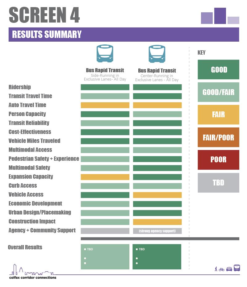
11 Basis for Decision and Decision-Making Process Screening criteria/evaluation Technical requirements Community input: Task Force Technical Working Group Broader public feedback Mobility Benefits Technical Viability Community Values Factors influencing the decision
12

13 Basis: Safety and Accessibility Island stations calm traffic Pedestrian refuges reduce crossing distance Shorter crossing distances = less exposure to vehicle traffic Eliminating unprotected lefts improves pedestrian, bicycle, and vehicular safety Station lighting enhances security
14 Basis: Optimizing Person Mobility 40k + 26k = 66,000 Center-running BRT results in an increase in daily person trips on Colfax of 14% No Action 25k + Center Running BRT 50k = 75,000 Provides the greatest expansion capacity allowing neighborhoods and businesses to grow around reliable, highcapacity transit
15 Basis: Investing in Transit Performance Ridership more than doubles to 50,000 daily rides by 2035 Transit travel time improved by 15 minutes compared to future baseline Optimal reliability for surface running transit Future proofing from delay as land-use, traffic, and curb uses change

16 Basis: Building Vital Neighborhoods Around Transit Opportunity for Street Trees Unique lighting Wider sidewalks Attractive, vertical features distinguish street Expanded Furniture Zone

17 Project Features: Street Design Pedestrian crossings at signalized crossings every 700 or less Left turn lanes at signalized intersections Prioritize curb parking/loading and expanded sidewalks EXCEPTIONS: Major arterial crossings w/ large truck turns Terminal locations Far-side of intersection stations Center running way; median to vary in width

18 Project Features: Full Transit Stations High Quality Shelters Off Board Payment Line Level Branding Lighting and Security C O L F A X Public Art Features System Traveler Information Protection from Traffic


19 Project Features: Integrated Operations All corridor buses use one set of stations between Yosemite and Civic Center
20 Areas for Further Refinement Station Locations Branding Station Design Corridor Bus Operating Plan Curb Use and Mitigations Median Treatments Sidewalk Expansion & ADA Improvements Bike Facility Crossing Traffic Operations and Mitigations
21 Medians, Sidewalks, & Streetscaping Opportunities
22 . Task Force Discussion What is the preferred approach for balancing sidewalk and median space in the corridor? This applies to areas where cross sections are approximately =>80 curb-to-curb and =>100 property lineto-property line, generally east of Colorado.

23 23 Narrow Sidewalk - Wide Median Median Shade trees Maintenance challenges Buses run directly adjacent Ped refuge opportunity Sidewalk No tree opportunity Limited frontage zone opportunities (awnings, open doors)
24 Consulting 24 Associates, Inc. Modest Median Modest Sidewalk Median Shrubs, plantings, flowers, swales Maintenance challenges Buses run directly adjacent Ped refuge opportunity Sidewalk Ornamentals Limited frontage zone opportunities (awnings, open doors)
25 .25 Wide Sidewalk - Narrow Median Median Decorative fencing Maintenance challenge: snow pileup No ped refuge opportunity (except at stations) Sidewalk Shade trees along walking zone Opportunity for café seating
: South")
26 10 Median (including curb): South Broadway

27 27 10 Median: Lakewood

28 Nelson\Nygaard 28 Consulting Associates, Inc. 8 Median: Boulder

29 Nelson\Nygaard 29 Consulting Associates, Inc. Median with small trees (Nantes)

30 Nelson\Nygaard 30 Consulting Associates, Inc. Decorative Fencing (Malmo)

31 Nelson\Nygaard 31 Consulting Associates, Inc. Decorative Fencing (Nantes)

32 Nelson\Nygaard 32 Consulting Associates, Inc. Decorative Fencing (Eugene)

33 Nelson\Nygaard 33 Consulting Associates, Inc. Decorative Fencing (Colfax Ave)

34 Nelson\Nygaard 34 Consulting Associates, Inc. 16 Sidewalk: 17 th Street
")
35 Nelson\Nygaard 35 Consulting Associates, Inc. 18 Sidewalk (State Street, Madison)


36 .36 Three Approaches for Balancing Sidewalk and Median Space Narrow Sidewalk Wide Median Modest Median Modest Sidewalk Wide Sidewalk Narrow Median
37 Left Turn & Pedestrian Crossing Opportunities
38 Nelson\Nygaard 38 Consulting Associates, Inc. Task Force Discussion Where will left turns be allowed from Colfax? What is potential spacing between those turns? Where are potential opportunities for new signals? NOTE: Colfax Connections will continue to refine station spacing, station location, pedestrian crossing opportunities, left-turn and business access, and other detailed elements of street design.
39 Nelson\Nygaard 39 Consulting Associates, Inc. Traffic signal locations Use existing protected crossing spacing as base input
40 Center-Running BRT: Community Outreach and Preference Survey


41 Community Outreach Process: Late 2017-Early 2018 Traditional tools Partner outreach Roadshow presentations Media relations Digital engagement Innovative outreach Office hours Pop-up events Project info and input kiosk Community preference survey

42 15L ROUTE IMPROVEMENTS Colfax Corridor Connections Task Force November 15, 2017
 as some rail corridors First major capital investment since stops were constructed 30+ years")
43 15L Project Overview RTD grant funded project to improve 15L stops and operations Short-term opportunity to improve passenger experience on East Colfax Total project budget: $11 million FTA Ladders of Opportunity Grant: $5 million East Colfax bus routes 15/15L serve as many passengers per day (over 20K) as some rail corridors First major capital investment since stops were constructed 30+ years ago 43


44 15L Project Area Civic Center Station Civic Center Station Rehabilitation Currently under construction Set to open later this year 15/15L connection with the Broadway stops I-225 Corridor (R Line) Opened Feb 2017 Colfax is the iconic station on the line and provides transfers to the 15/15L at the Potomac Stop 44


45 15L Project Status Defined project scope with Aurora and Denver 37 total stop locations 12 bus bulbs / curb extensions 8 queue bypass lanes Received environmental clearance from FTA Began implementation of Transit Signal Priority (TSP) Developed enhanced bus shelter design Incorporated feedback from an onboard passenger survey Bus Bulb/Curb Extension Source: RTD Queue Bypass Lane Source: AC Transit (Oakland, CA) 45


46 Survey Bus Stop Elements Shelter Options Glass Walls Metal and Glass Walls No Walls Security & Comfort Elements Cameras Security Patrols Lighting Benches Passenger Information Printed Schedules Digital Schedules with Ads Real-Time Schedule Information with Ads 46

47 Survey Results Most valued elements: Glass bus shelter walls Real-time information Benches Utility Values for Bus Stop Elements Least valued elements: Metal and glass shelter walls Shelters with no walls Most and least valued elements consistent between demographics and onboard vs stakeholder version 47


48 15L Enhanced Shelter Design All stops will include shelters with: Transparent Weather Protection Security cameras Lighting Passenger information Look for opportunities to add additional benches Electronic passenger information will be implemented at a minimum of 6 locations as a pilot project 48

49 15L Next Steps / Project Schedule Current Tasks: Work through CDOT and Denver/Aurora design review and approval processes Stakeholder updates Mid 2018: Issue RFP for a contractor End of 2019: Construction complete 49

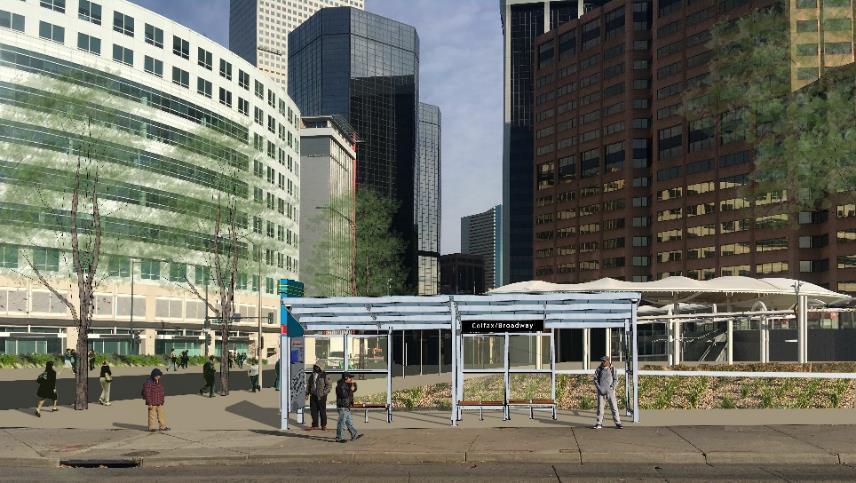
50 Civic Center Stop Renderings 50
51 Center-Running BRT: Next Steps and Path Forward
52 Where Do We Go From Here? Broad-based community outreach we need your help: Community survey Roadshow presentations Neighborhood events Newsletters Other ideas? Next Task Force meeting: Early 2018
53
Technical Working Group November 15, 2017
 Technical Working Group November 15, 2017 Welcome and Introductions Project Partners Regional Transportation District (RTD) Colorado Department of Transportation (CDOT) Denver Regional Council of Governments
Community Task Force March 14, 2018
 Community Task Force March 14, 2018 Welcome and Introductions Project Partners Regional Transportation District (RTD) City of Aurora Colorado Department of Transportation (CDOT) Denver Regional Council
Community Task Force July 25, 2017
 Community Task Force July 25, 2017 Welcome and Introductions Project Partners Regional Transportation District (RTD) Colorado Department of Transportation (CDOT) Denver Regional Council of Governments
Community Task Force August 8, 2018
 Community Task Force August 8, 2018 Welcome and Introductions Project Partners Regional Transportation District (RTD) City of Aurora Colorado Department of Transportation (CDOT) Denver Regional Council
Community Task Force October 5, 2017
 Community Task Force October 5, 2017 Welcome and Introductions Project Partners Regional Transportation District (RTD) Colorado Department of Transportation (CDOT) Denver Regional Council of Governments
Outreach Approach RENEW SF served as the primary liaison with the North Beach community; the Chinatown. Executive Summary
 Executive Summary Executive Summary The Columbus Avenue Neighborhood Transportation Study s objective is to identify changes to transportation infrastructure and policies that could enhance the livability
Bus Rapid Transit ALTERNATIVES ANALYSIS. Open House
 Bus Rapid Transit ALTERNATIVES ANALYSIS Open House June 23, 2015 Open House Meeting Agenda Agenda Introductions What is BRT? Project Goals Study Tasks Next steps Discussion PVTA Bus Rapid Transit Study
Arterial Transitway Corridors Study
 Arterial Transitway Corridors Study February 2012 Arterial Transitway Corridors Study Overview Corridor Features and Demographics 11 study corridors, 95 route miles Routes: 86,000 daily rides and half
Arterial Transitway Corridors Study. Ave
 Arterial Transitway Corridors Study Ave January 2012 Arterial Transitway Corridors Study Overview Corridor Features and Demographics 11 study corridors, 95 route miles 86,000 daily rides and half of existing
Main-McVay Transit Study: Phase 2 Options Definition and High Level Constraints Evaluation
 Main-McVay Transit Study: Phase 2 Options Definition and High Level Constraints Evaluation APRIL 2016 A collaborative study between: For Additional Information or to Comment If you would like additional
THE ALAMEDA CONCEPT DESIGN COMMUNITY MEETING 3. A Plan for The Beautiful Way JANUARY 28, 2010
 CONCEPT DESIGN COMMUNITY MEETING 3 JANUARY 28, 2010 AGENDA INTRODUCTION COMMUNITY INPUT ROADWAY STUDIES STREETSCAPE DESIGN STATIONS DISCUSSION SUMMARY AND DISCUSSION NEXT STEPS CLOSE INTRODUCTION SCHEDULE
BETHEL ROAD AND SEDGWICK ROAD CORRIDOR STUDY
 DRAFT PLAN City Council Meeting August 14, 2017 STUDY AREA Sedgwick Corridor State Route 160, principal arterial with Class 3 access management designation, commuter and freight route, connection to SR
PROJECT OVERVIEW. Auburn Station Access Improvements Project
 ROJECT OVERVIEW Auburn Station Access Improvements roject Average daily ridership on the south Sounder line has been growing rapidly over the past few years and is expected to increase approximately 70
95 th Street Corridor Transportation Plan. Steering Committee Meeting #2
 95 th Street Corridor Transportation Plan Steering Committee Meeting #2 February 18, 2015 PURPOSE OF THE MEETING Update Steering Committee Present Community/Stakeholder Survey Results Present Transportation
A Guide to Great Streets: The Basics. September 25, 2009
 A Guide to Great Streets: The Basics September 25, 2009 Streets are more than connectors, they are the city 2 Streets are the glue that hold a city together 3 Streets are the means in which a city is perceived
Building Great Neighbourhoods BELLEVUE AND VIRGINIA PARK
 Building Great Neighbourhoods BELLEVUE AND VIRGINIA PARK This is Meeting 2 Unfortunately, some residents in Bellevue and Virginia Park received the wrong information for this public open house (Meeting
Providence Downtown Transit Connector STAKEHOLDER MEETING #2. Stakeholder Meeting #1 October 24, 2016
 Providence Downtown Transit Connector STAKEHOLDER MEETING #2 Stakeholder Meeting #1 October 24, 2016 February 2017 1 AGENDA 1 DTC Goals and Expectations 2 Street Design Concepts 3 Potential Benefits and
In station areas, new pedestrian links can increase network connectivity and provide direct access to stations.
 The Last Mile Planning for Pedestrians Planning around stations will put pedestrians first. Making walking to stations safe and easy is important; walking will be a part of every rapid transit Accessible
Welcome to the Quebec Alternatives Analysis Public Meeting
 Welcome to the Public Meeting Please sign in. Public Comment Please fill out a comment card and tell us what you think. Check back or comment any time at: www.quebecalternatives.com Project Area Technical
HARRISON STREET/OAKLAND AVENUE COMMUNITY TRANSPORTATION PLAN
 HARRISON STREET/OAKLAND AVENUE Community Workshop #4: Draft Plan Review December 3, 2009 D E S I G N, C O M M U N I T Y & E N V I R O N M E N T INTRODUCTIONS Key Project Staff: Alisa Shen, Project Manager,
Chapter 3 BUS IMPROVEMENT CONCEPTS
 Chapter 3 BUS IMPROVEMENT CONCEPTS The purpose of this chapter is to describe potential bus improvement strategies and potential impacts or implications associated with BRT implementation within the existing
Geary Corridor Bus Rapid Transit SFMTA Citizens Advisory Committee
 Geary Corridor Bus Rapid Transit SFMTA Citizens Advisory Committee Project Update SAN FRANCISCO COUNTY TRANSPORTATION AUTHORITY SAN FRANCISCO MUNICIPAL TRANSPORTATION AGENCY August 6, 2015 Project Overview
TULSA CITY COUNCIL CAPITAL IMPROVEMENT PROGRAM TASK FORCE MEETING JANUARY
 CITY OF TULSA BICYCLE & PEDESTRIAN INFRASTRUCTURE TULSA CITY COUNCIL CAPITAL IMPROVEMENT PROGRAM TASK FORCE MEETING JANUARY 31, 2013 CITY OF TULSA ENGINEERING SERVICES DEPARTMENT CITY OF TULSA ADA TRANSITION
North Shore Transportation Improvement Strategy
 North Shore Transportation Improvement Strategy Preliminary, Near-term Recommendation 2016 April Transportation Improvement Strategy (TIS) Comprehensive and Analytical A multi-modal transportation strategy
Better Market Street. Engineering, Maintenance & Safety Committee (EMSC) February 28, 2018
 February 28, 2018") Better Market Street Engineering, Maintenance & Safety Committee (EMSC) February 28, 2018 1 Market Street Market Street - San Francisco by rulenumberone2 2 Market Street is the... City s busiest pedestrian
Better Market Street Engineering, Maintenance & Safety Committee (EMSC) February 28, 2018 1 Market Street Market Street - San Francisco by rulenumberone2 2 Market Street is the... City s busiest pedestrian
complete streets design and construction standards public primer City of Edmonton
 complete streets design and construction standards public primer City of Edmonton introduction Complete Streets are streets for everyone: people who walk, wheel, bike, take transit, or drive. They are
Community Meeting February 27, 2007 Dorchester Avenue Transportation & Streetscape Improvements Action Plan February 27, 2007
 Community Meeting Tonight s Agenda 6:00 Introductions South Boston/Dot Ave Improvement Study Background 6:15 Consultant Introductions Review of Scope and Schedule Review of Proposed Corridor Wide Guidelines
Hennepin Avenue Reconstruction Washington Avenue to 12 th Street
 CITY OF MINNEAPOLIS Hennepin Avenue Reconstruction Washington Avenue to 12 th Street April 2016 1 Upcoming Opportunities Public Meeting #2 April 25, 2016 Minneapolis Central Library Doty Board Room Repeat
MARTIN LUTHER KING JR. WAY
 OCTOBER 2011 40 Vision and Goals The Martin Luther King, Jr. Way Illustrative Master Plan that follows has been developed through a process of community involvement. It expresses a long term vision for
Lawrence Avenue Streetscape Concepts August 30, 2011
 Lawrence Avenue Streetscape Concepts August 30, 2011 Neighborhood Context Phase II: River to Western Ave. Phase I: Western Ave. to Clark St. Key Map Lawrence Ave. Existing Streetscape Conditions East of
Why invest in the 1 Street S.W. Corridor?
 Why invest in the 1 Street S.W. Corridor? This project is an investment in the Beltline Community and Calgary s economy. It is anticipated that The City s investment along this corridor will help with
Joseph Iacobucci. James Czarnecky, AICP
 Chicago s Bus Rapid Transit Program Joseph Iacobucci Chicago Transit Authority Manager, Strategic Planning and Policy Chicago, IL James Czarnecky, AICP AECOM BRT Program Manager Chicago, IL Chicago s Multimodal
Eliminate on-street parking where it will allow for a dedicated bus only lane %
 Traffic Dashboard Priorities Survey Responses Introduction 1) Are you familiar with bus rapid transit (BRT)? a. No, BRT is new to me. 597 23.5% b. I ve heard of BRT, but I don t know much about it. 1,136
Item to be Addressed Checklist Consideration YES NO N/A Required Description Complete Streets Guidelines
 Passaic County Complete Streets Checklist - Concept Development Project Name Item to be Addressed Checklist Consideration YES NO N/A Required Description Complete Streets Guidelines Existing Plans Have
San Jose Transportation Policy
 San Jose Transportation Policy Protected Intersections in LOS Policies to Support Smart Growth Presented by: Manuel Pineda City of San Jose Department of Transportation Bay Area Map San Francisco Oakland
 Community and Business Outreach November 2015 Goal #1: Improve safety in the corridor Goal #2: Make a more livable corridor Goal #3: Improve mobility for all Data Collection Alternatives Recommendations
Mission-Geneva Transportation Study Community Workshop 2 July 8, 2006
 Community Workshop 2 July 8, 2006 Small Group Workbook 1 Basic Improvements on Mission Street Streetscape. Pedestrian-scale lighting; landscaping; community art on utility boxes; more (possibly unique)
Tonight is for you. Learn everything you can. Share all your ideas.
 Strathcona Neighbourhood Renewal Draft Concept Design Tonight is for you. Learn everything you can. Share all your ideas. What is Neighbourhood Renewal? Creating a design with you for your neighbourhood.
Bicycle and Pedestrian Advisory Committee (BPAC) November 21, 2013
 November 21, 2013") Bicycle and Pedestrian Advisory Committee (BPAC) November 21, 2013 OVERALL LAND USE CONCEPT Overall Broadway Valdez District: 95.5 acres (35.1 acres right-of ways + 60.4 acres developable land) Plan Subareas:
Bicycle and Pedestrian Advisory Committee (BPAC) November 21, 2013 OVERALL LAND USE CONCEPT Overall Broadway Valdez District: 95.5 acres (35.1 acres right-of ways + 60.4 acres developable land) Plan Subareas:
Scope of the Transit Priority Project
 Transit Planning Committee #1 March 19, 2015 Scope of the Transit Priority Project Review of the 2010 plan Analysis of Transit Priority Measures Preliminary plans for rapid transit Recommendations for
Arterial Transitway Corridors Study. Sept. 26, 2011
 Arterial Transitway Corridors Study Sept. 26, 2011 Purpose of Study Study 11 urban corridors in Minneapolis, St. Paul and surrounding communities Develop service and facilities plan to improve Transit
42nd Ave N Reconstruction
 CITY OF MINNEAPOLIS 42nd Ave N Reconstruction Community Meeting #2 May 2016 6:00 7:30 p.m. 5/16/2016 1 Purpose of Meeting Inform: Provide an overview of project, identify anticipated scope of work, and
M14A/D Select Bus Service
 M14A/D Select Bus Service Manhattan Community Board 6: April 1, 2019 New York City Transit 2 Background M14 Select Bus Service M14 was identified as a critical future SBS corridor in past BRT studies as
 COMPLETE STREETS CHECKLIST City of Philadelphia The City of Philadelphia's Complete Streets policies are designed ensure that city streets are safe, comfortable and convenient for people of all ages and
Southview Blvd & 3 rd Avenue Improvement Project. Public Open House December 4, to 7pm
 Southview Blvd & 3 rd Avenue Improvement Project Public Open House December 4, 2014 5 to 7pm Southview Blvd & 3 rd Avenue Public Information Meeting Agenda Presentation 5:30 to 6:15 pm Purpose of Project
EL CAMINO REAL BUS RAPID TRANSIT PROJECT
 EL CAMINO REAL BUS RAPID TRANSIT PROJECT Would upgrade the current 522 Rapid Bus to BRT status by making changes to El Camino Real and The Alameda that make transit FAST, FREQUENT AND RELIABLE and make
Omaha s Complete Streets Policy
 Omaha s Complete Streets Policy (Adopted August 2015) VISION To create great places and enhance our quality of life, the City of Omaha will provide safe, accessible streets for all users. Complete Streets
Traffic Improvements for the Transit Oriented Development District (TODD) Meriden Public Library March 11, 2014
 Meriden Public Library March 11, 2014") Traffic Improvements for the Transit Oriented Development District (TODD) Meriden Public Library March 11, 2014 Project Overview Coordinate roadway improvements with other major projects HUB Flood Control
Traffic Improvements for the Transit Oriented Development District (TODD) Meriden Public Library March 11, 2014 Project Overview Coordinate roadway improvements with other major projects HUB Flood Control
Building Great Neighbourhoods LANSDOWNE
 Building Great Neighbourhoods LANSDOWNE We are here today to Explain how the City is investing in improving your neighbourhood and how your neighbourhood will be improved to meet current City standards.
Columbia Pike Implementation Team (CPIT) Meeting
 Meeting") Columbia Pike Implementation Team (CPIT) Meeting November 30, 2010 Agenda Introductions / Purpose of Meeting Review of project goals Multimodal project: 10% street design between the curbs Discussion Multimodal
Columbia Pike Implementation Team (CPIT) Meeting November 30, 2010 Agenda Introductions / Purpose of Meeting Review of project goals Multimodal project: 10% street design between the curbs Discussion Multimodal
Telegraph Avenue Complete Streets DRAFT Recommendations. Oakland Public Works Department September 11 and 13, 2014 Open Houses
 Telegraph Avenue Complete Streets DRAFT Recommendations Oakland Public Works Department September 11 and 13, 2014 Open Houses Presentation Overview What are complete streets? What problem are we trying
Planning Study SR 976. Project Advisory Team Meeting May 24, 2017
 ` SR 976 BIRD ROAD/SW 40TH STREET FROM SR 821/HEFT TO SR 5/US-1 Miami-Dade County, Florida FPID No.: 434845-4-22-01 Planning Study Project Advisory Team Meeting May 24, 2017 1 Agenda Introductions Project
WHAT IS BRT? Jack M. Gonsalves, PE, Parsons Brinckerhoff, Inc. February 22, 2012
 WHAT IS BRT? Jack M. Gonsalves, PE, Parsons Brinckerhoff, Inc. February 22, 2012 What is Bus Rapid Transit (BRT)? A flexible, high performance rapid transit mode that combines a variety of physical, operating,
RapidRide Roosevelt Seat Sea t t le t le Depa De r pa t r men men t of Sept T an r sp an or sp t or a t t a ion
 RapidRide Roosevelt Seattle Bicycle Advisory Board 1 Our mission, vision, and core values Mission: deliver a high-quality transportation system for Seattle Vision: connected people, places, and products
Brooklyn Boulevard (County Road 152) Reconstruction Project Phase I. OPEN HOUSE June 20, 2017
 Reconstruction Project Phase I. OPEN HOUSE June 20, 2017") Brooklyn Boulevard (County Road 152) Reconstruction Project Phase I OPEN HOUSE June 20, 2017 Brooklyn Boulevard (County Road 152) Phase I Project Partners Project Lead Other Project Partners include Brooklyn
Brooklyn Boulevard (County Road 152) Reconstruction Project Phase I OPEN HOUSE June 20, 2017 Brooklyn Boulevard (County Road 152) Phase I Project Partners Project Lead Other Project Partners include Brooklyn
ALTERNATIVES SCREENING REPORT
 VAN NESS AVENUE BUS RAPID TRANSIT (BRT) ALTERNATIVES SCREENING REPORT Revised Draft, 3/28/08 San Francisco County Transportation Authority 1 Introduction The San Francisco County Transportation Authority
Beyond First First Last Last Mile Strategies. APA National Conference April 3, 2016 Chelsea Richer, AICP Fehr & Peers
 Beyond First First Last Last Mile Strategies APA National Conference April 3, 2016 Chelsea Richer, AICP Fehr & Peers 1 Beyond First Last Mile Strategies APA National Conference Jeremy Klop, AICP, Fehr
WELCOME. Purpose of the Open House. Update you on the project. Present a draft recommended plan. Receive your input
 WELCOME Purpose of the Open House The Town of Smiths Falls has initiated the Beckwith Street Redevelopment Plan that includes the preparation of a streetscape functional design for the renewal of Beckwith
Major Bike Routes 102 Avenue Workshop April 21, 2015
 Major Bike Routes 102 Avenue Workshop April 21, 2015 Our Purpose Today Provide context on how Major Bike Routes fit into Edmonton s future Share information on what we heard in our last phase, and how
Draft Recommended List of Potential Projects
 Draft Recommended List of Potential Projects To Pursue Using the GID Fund Recommendations are based on results of public outreach, City Council discussion, and staff evaluation of all project ideas identified
122 Avenue: 107 Street to Fort Road
 : 107 Street to Fort Road November 24, 2015 4:30 8:00 p.m. Meeting Purpose Summarize project work completed to date Share results of public input from Phase 1 Share the draft concept plan and proposed
WELCOME. City of Eden Prairie West 70 th Street
 WELCOME City of Eden Prairie West 70 th Street Project Schedule Sep Oct Nov Dec Jan Feb Mar Apr May Jun Jul Aug >>> May WEST SEGMENT Concept Plan Fall 2014 Plan Development Winter 2014 Summer 2015 Construction
Transportation Planning Division
 Transportation Planning Division Presentation Outline Study Tasks Recap of Previous Meetings Data Collected Focus Areas within Study Limits Design Principles Tool Box Recommended Concepts Schedule Moving
Arlington County 10-Year Transit Development Plan & Premium Transit Network Briefing. May 2016
 Arlington County 10-Year Transit Development Plan & Premium Transit Network Briefing May 2016 Overview 10-Year Transit Development Plan Premium Transit Network Columbia Pike service concept Premium amenities
Environment and Public Works Committee Presentation
 Mixed Use Centers Complete Streets Guidelines Project Environment and Public Works Committee Presentation December 10, 2008 Project Objectives: Conduct an inter-departmental and agency process to study
Advancing Transportation Choices in Des Moines. MPO Environmental Roundtable January 9, 2018
 Advancing Transportation Choices in Des Moines MPO Environmental Roundtable January 9, 2018 Presented by Jennifer McCoy, PE, PTOE City Traffic Engineer Agenda Des Moines Area Transportation Planning Connect
Designing Streets for Transit. Presentation to NACTO Designing Cities Kevin O Malley Managing Deputy Commissioner 10/24/2014
 Designing Streets for Transit Presentation to NACTO Designing Cities Kevin O Malley Managing Deputy Commissioner 10/24/2014 Chicago -- Streets for Transit TODAY Jeffery Jump Transit Signal Priority Central
Appendix A-2: Screen 1 Alternatives Report
 Appendix A-2: Screen 1 Alternatives Report SCREEN 1 ALTERNATIVES REPORT Western & Ashland Corridors Bus Rapid Transit (BRT) Project Prepared for Chicago Transit Authority 567 West Lake Street Chicago,
Pine Hills Road Pedestrian/Bicycle Safety Study Board of County Commissioners Work Session
 Pine Hills Road Pedestrian/Bicycle Safety Study Board of County Commissioners Work Session February 20, 2018 Meeting Agenda Study Overview Existing Conditions Access Management Potential Gateway Features
SAN FRANCISCO MUNICIPAL TRANSPORTATION AGENCY
 THIS PRINT COVERS CALENDAR ITEM NO. : 10.2 DIVISION: Sustainable Streets BRIEF DESCRIPTION: SAN FRANCISCO MUNICIPAL TRANSPORTATION AGENCY Adopting Conceptual Proposal for Streetscape Improvements to Broadway,
Mayor s Bicycle Advisory Council. Wednesday, December 13 th, 2017
 Mayor s Bicycle Advisory Council Wednesday, December 13 th, 2017 Bicyclist Fatalities, Year to Date (January 1 November 30, 2017) - MBAC Briefing Bicyclist Fatality Statistics Year to date total, 2017
PROJECT OVERVIEW. 20th Avenue Project Limits (Lincoln Way to Wawona St)
") PROJECT OVERVIEW In 2014, San Francisco adopted Vision Zero as City policy, with a commitment to eliminate all traffic deaths in the City by 2024. nue Project Limits (Lincoln Way to St) Collision data
PROJECT OVERVIEW In 2014, San Francisco adopted Vision Zero as City policy, with a commitment to eliminate all traffic deaths in the City by 2024. nue Project Limits (Lincoln Way to St) Collision data
Building Great Neighbourhoods QUEEN ALEXANDRA
 Building Great Neighbourhoods QUEEN ALEXANDRA We are here today to Explain how the City is investing in improving your neighbourhood and how your neighbourhood will be improved to meet current City standards.
C Line Rapid Bus Preliminary Station Design
 C Line Rapid Bus Preliminary Station Design C Terrence Anderson, Community Outreach Coordinator Shawn Walding, Senior Engineer Metro Transit TAAC February 1, 2016 1 C Line project overview Substantially
Citizen Advisory Group Meeting #8 May 5, Welcome. Today s meeting will focus on: Land Use & Transportation CHARLOTTEPLANNING.
 Citizen Advisory Group Meeting #8 May 5, 2010 Welcome. Today s meeting will focus on: Land Use & Transportation CHARLOTTEPLANNING.ORG Meeting Agenda Handouts: o Meeting Agenda o Summary of East Seventh
Complete Streets Chicago: Data Driven Design. Luann Hamilton Deputy Commissioner
 Complete Streets Chicago: Data Driven Design Luann Hamilton Deputy Commissioner AGENDA Chicago s goals Complete Streets & Sustainable Infrastructure Guides Data-Driven Planning Setting goals Scoping/research
UDC Street Cross Sections
 UDC Street Cross Sections Local Street - Downtown Local Street Mountable Curb Local Street Vertical Curb Alley Major Arterial Minor Arterial Residential Lane Residential Collector Residential Collector
Executive Summary Route 30 Corridor Master Plan
 Route Corridor Master Plan Project Overview The Route Corridor Master Plan is a coordinated multimodal transportation and land use plan for the entire stretch of Route through East Whiteland Township,
City of Sammamish. Welcome. Issaquah-Fall City Road Improvements Project Phase I Design: 242nd Avenue SE to Klahanie Drive SE
 Welcome Welcome to the third community meeting for the Issaquah-Fall City Road Improvements Project. AGENDA 6:00 p.m. Welcome and sign-in 6:10 p.m. Presentation 6:50 p.m. Open house Learn about the roadway
A District Council of the Urban Land Institute
 A District Council of the Urban Land Institute Thank you to our sponsors! A District Council of the Urban Land Institute Thank you to our Community Partners! A District Council of the Urban Land Institute
A CHANGING CITY. of Edmonton, it is essential that it reflects the long-term vision of the City.
 A CHANGING CITY By the year 2040, Edmonton will be home to more than 1 million people. To accommodate growth and support a healthy and compact city, we need a new approach to development/redevelopment
RTD Board of Directors Operations and Customer Service Committee
 16th Street Mall Project Update The Mall Experience RTD Board of Directors Operations and Customer Service Committee January 23, 2018 16 th Street Mall Recap Concern with maintenance issues and costs launched
Beach Cities Living Streets Design Manual and Aviation Boulevard Multimodal Corridor Plan
 Beach Cities Living Streets Design Manual and Aviation Boulevard Multimodal Corridor Plan AGENDA 1 Introductions & Project Scope 2 Public Outreach Recap 3 Living Streets Design Manual 4 Aviation Boulevard
5. RUNNINGWAY GUIDELINES
 5. RUNNINGWAY GUIDELINES These guidelines should be considered collectively when making runningway decisions. A runningway is the linear component of the transit system that forms the right-of-way reserved
Bus Rapid Transit Plans
 Twin Cities Region Bus Rapid Transit Plans ULI Minnesota Workshop Connecting Bus Rapid Transit to the Community December 15, 2009 John Levin Director of Service Development Metro Transit Metropolitan Area
Strategies for Maintaining & Renewing Innovative Street Projects. Elyse Parker, Director of Policy & Innovation, City of Toronto NACTO, LA, 2018
 Strategies for Maintaining & Renewing Innovative Street Projects Elyse Parker, Director of Policy & Innovation, City of Toronto NACTO, LA, 2018 1 OUR ASSETS $12B in Assets $20B Replacement Cost $372M Capital
Lee s Summit Road Improvement Study Public Open House June 7, 2007 Summary of Comment Card Responses
 Lee s Summit Road Improvement Study Public Open House June 7, 2007 Summary of Comment Card Responses Introduction At the Lee s Summit Road Improvement Study Public Open House held Thursday, June 7, 2007
Complete Streets in Constrained Corridors: Chicago s Central Loop BRT
 Complete Streets in Constrained Corridors: Chicago s Central Loop BRT NACTO Designing Cities Conference October 24, 2012 Luann Hamilton, Deputy Commissioner What is BRT? Bus-based system that improves
Saskatchewan Drive Roadway Rehabilitation and Shared-Use Path Widening
 Saskatchewan Drive Roadway Rehabilitation and Shared-Use Path Widening We are here today to present the draft plan for the Saskatchewan Drive Roadway Rehabilitation and Shared-Use Path Widening project
CURBSIDE ACTIVITY DESIGN
 5 CURBSIDE ACTIVITY DESIGN This chapter provides design guidance for separated bike lanes adjacent to curbside activities including parking, loading and bus stops. Typical configurations are presented
Southwest Bus Rapid Transit (SW BRT) Functional Planning Study - Executive Summary January 19 LPT ATTACHMENT 2.
 Functional Planning Study - Executive Summary January 19 LPT ATTACHMENT 2.") Southwest Bus Rapid Transit (SW BRT) Functional Planning Study - Executive Summary 2011 January 19 1 of 19 Introduction This executive summary presents the results of the Southwest Bus Rapid Transit (SW
Southwest Bus Rapid Transit (SW BRT) Functional Planning Study - Executive Summary 2011 January 19 1 of 19 Introduction This executive summary presents the results of the Southwest Bus Rapid Transit (SW
Agenda. Overview PRINCE GEORGE S PLAZA METRO AREA PEDESTRIAN PLAN
 PRINCE GEORGE S PLAZA METRO AREA PEDESTRIAN PLAN May 28, 2008 Agenda Welcome and introductions Project overview and issue identification Planning context and strengths Design challenges and initial recommendations
PUBLIC REALM MASTER PLAN
 WESTSHORE BUSINESS DISTRICT PUBLIC REALM MASTER PLAN MASTER PLAN COMMITTEE MEETING MARCH 20, 2013 WESTSHORE BUSINESS DISTRCT PUBLIC REALM MASTER PLAN MACRO-SCALE CONCEPT: A PUBLIC REALM FRAMEWORK DEFINED
Vision: Traditional hamlet with an attractive business/pedestrian friendly main street connected to adjacent walkable neighborhoods
 N D. Focus Area II Vision: Traditional hamlet with an attractive business/pedestrian friendly main street connected to adjacent walkable neighborhoods Transit Road Focus Area II is located in the Hamlet
COWETA HIGH SCHOOL AND EAST HIGHWAY 51
 COWETA HIGH SCHOOL AND EAST HIGHWAY 51 Lack of sidewalks along Ben Lumpkin Rd. Lack of crosswalks and ramps at intersection. Hwy 51 is wide to cross as a pedestrian. No ADA compliance or connection to
BALBOA AREA: TRANSPORTATION PROJECTS & PLANNING
 BALBOA AREA: TRANSPORTATION PROJECTS & PLANNING TRANSPORTATION FOR ALL AGES, ABILITIES & MEANS CHANGING PATTERNS: TRENDING TO WALKING, BIKING, TRANSIT San Francisco s Change in Number of Commuters by Mode
9. TRANSIT ACCOMMODATIONS
 9. TRANSIT ACCOMMODATIONS INTRODUCTION...1 Broward County County-Wide Community Design Guidebook...1 FDOT District Four Transit Facilities Guidelines...2 ESSENTIAL PRINCIPLES OF DESIGNING STREETS FOR TRANSIT...3
Kennedy Plaza and Providence Downtown Transit Connector PUBLIC MEETING. Stakeholder Meeting #1 October 24, 2016
 Kennedy Plaza and Providence Downtown Transit Connector PUBLIC MEETING Stakeholder Meeting #1 October 24, 2016 May 2017 1 WHAT IS THE DTC? 1.5 mile corridor between Providence Station and the Hospital
Commerce Street Complete Street Project from Good Latimer Expressway to Exposition Avenue
 Commerce Street Complete Street Project from Good Latimer Expressway to Exposition Avenue T A N Y A B R O O K S A S S I S T A N T D I R E C T O R M O B I L I T Y P L A N N I N G M O B I L I T Y A N D S
Transit Choices December 8, 2016
 Transit Choices December 8, 2016 Agenda 1. Network Redesign Status 2. Public Hearings & Bus Stops 3. Public Education Plan 4. Capital Projects Update 1 st Draft Winter Outreach October 2015 February 2016