Community Task Force August 8, 2018
|
|
|
- Lindsay Lawrence
- 5 years ago
- Views:
Transcription


1 Community Task Force August 8, 2018
2 Welcome and Introductions
3 Project Partners Regional Transportation District (RTD) City of Aurora Colorado Department of Transportation (CDOT) Denver Regional Council of Governments (DRCOG)
4 Meeting Purpose and Agenda
5 Meeting Purpose Update on progress, schedule and next steps Discuss design approach and funding assumptions Review and gather feedback on conceptual (10%) design
")
6 Agenda Project update Process and next steps Preliminary funding assumptions Design methodology Pedestrian Safety Project Open house: Discuss and review conceptual (10%) design
7 Project Update
8 Corridor Development Timeline Opportunity for Stakeholders and Public To Influence Project Design Broad Definition of Project Design Detail Alternatives Analysis Conceptual Design & Environmental Analysis months Engineering & Design 18 months months Construction Revenue Service Ongoing Federal Transit Administration Project Development We Are Here Locally Preferred Alternative Definition of mode & alignment Conceptual station locations Operating plan Local decision Concept Design & Environmental Clearances Design detail determined Environmental impacts identified Fully Designed and Funded Project Design complete Finance package
9 Coordination with Related Projects Intersection, pedestrian safety and streetscaping Neighborhood Planning Initiatives (east / east central) RTD 15L improvements Others
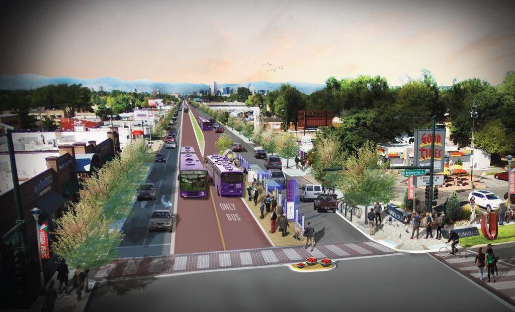
10 10% Designs (BRT+ Pedestrian Mobility) Conceptual layout and function

11 30% Design (BRT+ Streetscaping) Begins to evolve conceptual layout and functionality

12 Final Design + Construction Starting 2020 / 2021
13 Preliminary Funding Assumptions
14 Current and Potential Funding Sources Denver General Obligation Bond $55 million Other funding sources may include: Federal grant funding Statewide ballot initiatives Other local funding
15 Project Elements: What s included in funding assumptions? Station areas ~1 block in each direction (east/west) Pedestrian access and safety features ~4 mid-block crossings, sidewalks and curb extensions BRT and vehicle operations (between stations and new crossings) Curb-to-curb Buses Replacement of Rt 15 Fleet
16 Conceptual (10%) Design Methodology
17

18 Conceptual Station Area Design Design Methodology: How much space do we have? Maintains existing driveway access Left turn lanes at signalized intersections Varied median widths Prioritize curbside parking and loading Center running stations and bus lanes Expanded sidewalks and shorter/safer pedestrian crossings Preliminary design concept. Subject to change.

19 Conceptual Pedestrian Crossing Design Expanded sidewalks and shorter/safer pedestrian crossings Maintains existing driveway access Prioritize curbside parking and loading Stop light for pedestrian crossing Center running bus lanes Preliminary design concept. Subject to change.
20 Corridor-Wide Pedestrian Safety Project
21 Corridor-Wide Pedestrian Safety Project Prioritizing Intersections (Sheridan to Yosemite) Pedestrian crashes Conceptual Design (10% design) Coordinating with BRT design (East Colfax) Complete by October 2018 Integration with Next phase of BRT to begin in 2019 (including streetscape, etc.)
22 Design Example Preliminary design concept. Subject to change.
23 Pedestrian Safety Project: Potential Intersections Adams Clarkson Emerson Fairfax Gilpin Glencoe High Humboldt Ivy Jasmine Kalamath (Santa Fe) Kearney Knox Leyden Logan Lowell Marion Meade Milwaukee Ogden/Corona Osage (7th St) Park/Franklin Pearl Race Raleigh Sheridan Speer Stuart Tennyson Valentia Verbena Vine Vrain Wabash Washington Preliminary conceptual locations. Subject to change.
24 Open House Discussion
25 25 Open House Discussion Areas of emphasis for detailed design Local access Stop spacing and connectivity Traffic operations How are these areas addressed in the conceptual design? How does it all fit together? What s missing? Are there other areas that need special attention (e.g., walk experience, traffic operations, etc.)?

26 Conceptual BRT Stations and New Pedestrian Crossings 1. Mariposa 2. Delaware 3. Civic Center 4. Pennsylvania 5. Downing 6. Williams 7. York/Josephine 8. Steele 9. Colorado 10. Elm 11. Hudson 12. Krameria 13. Monaco 14. Quebec 15. Uinta 16. Yosemite Signalized Pedestrian Crossings 1. Madison 2. Bellaire 3. Tamarac 4. Willow Note: Certain project elements will continue to be refined as design progresses (e.g., station spacing/locations, pedestrian crossings, left-turns, etc.).

27 Corridor Map

28 Corridor-Wide Pedestrian Safety Project
29 29 Open House Discussion Conceptual BRT station areas New signalized/protected pedestrian crossings BRT corridor map (I-25 to Yosemite) Corridor-wide pedestrian safety project
30 Next Steps
31 Where Do We Go From Here? Completion of conceptual design Ongoing coordination with partners and related projects Planning for upcoming detailed (30%) design phase
32
Technical Working Group November 15, 2017
 Technical Working Group November 15, 2017 Welcome and Introductions Project Partners Regional Transportation District (RTD) Colorado Department of Transportation (CDOT) Denver Regional Council of Governments
Community Task Force March 14, 2018
 Community Task Force March 14, 2018 Welcome and Introductions Project Partners Regional Transportation District (RTD) City of Aurora Colorado Department of Transportation (CDOT) Denver Regional Council
Community Task Force November 15, 2017
 Community Task Force November 15, 2017 Welcome and Introductions Project Partners Regional Transportation District (RTD) Colorado Department of Transportation (CDOT) Denver Regional Council of Governments
Community Task Force July 25, 2017
 Community Task Force July 25, 2017 Welcome and Introductions Project Partners Regional Transportation District (RTD) Colorado Department of Transportation (CDOT) Denver Regional Council of Governments
Community Task Force October 5, 2017
 Community Task Force October 5, 2017 Welcome and Introductions Project Partners Regional Transportation District (RTD) Colorado Department of Transportation (CDOT) Denver Regional Council of Governments
Bus Rapid Transit ALTERNATIVES ANALYSIS. Open House
 Bus Rapid Transit ALTERNATIVES ANALYSIS Open House June 23, 2015 Open House Meeting Agenda Agenda Introductions What is BRT? Project Goals Study Tasks Next steps Discussion PVTA Bus Rapid Transit Study
COLFAX MULTIMODAL ACCESS STUDY
 COLFAX MULTIMODAL ACCESS STUDY Prepared for: City and County of Denver Public Works and City of Aurora Prepared by: David Evans and Associates with Alta Planning + Design and Apex Design FINAL STUDY REPORT
Commerce Street Complete Street Project from Good Latimer Expressway to Exposition Avenue
 Commerce Street Complete Street Project from Good Latimer Expressway to Exposition Avenue T A N Y A B R O O K S A S S I S T A N T D I R E C T O R M O B I L I T Y P L A N N I N G M O B I L I T Y A N D S
Agenda. Overview PRINCE GEORGE S PLAZA METRO AREA PEDESTRIAN PLAN
 PRINCE GEORGE S PLAZA METRO AREA PEDESTRIAN PLAN May 28, 2008 Agenda Welcome and introductions Project overview and issue identification Planning context and strengths Design challenges and initial recommendations
PRINCE GEORGE S PLAZA METRO AREA PEDESTRIAN PLAN
 PRINCE GEORGE S PLAZA METRO AREA PEDESTRIAN PLAN May 28, 2008 Agenda Welcome and introductions Project overview and issue identification Planning context and strengths Design challenges and initial recommendations
Chapter 3 BUS IMPROVEMENT CONCEPTS
 Chapter 3 BUS IMPROVEMENT CONCEPTS The purpose of this chapter is to describe potential bus improvement strategies and potential impacts or implications associated with BRT implementation within the existing
In station areas, new pedestrian links can increase network connectivity and provide direct access to stations.
 The Last Mile Planning for Pedestrians Planning around stations will put pedestrians first. Making walking to stations safe and easy is important; walking will be a part of every rapid transit Accessible
BETHEL ROAD AND SEDGWICK ROAD CORRIDOR STUDY
 DRAFT PLAN City Council Meeting August 14, 2017 STUDY AREA Sedgwick Corridor State Route 160, principal arterial with Class 3 access management designation, commuter and freight route, connection to SR
122 Avenue: 107 Street to Fort Road
 : 107 Street to Fort Road November 24, 2015 4:30 8:00 p.m. Meeting Purpose Summarize project work completed to date Share results of public input from Phase 1 Share the draft concept plan and proposed
A District Council of the Urban Land Institute
 A District Council of the Urban Land Institute Thank you to our sponsors! A District Council of the Urban Land Institute Thank you to our Community Partners! A District Council of the Urban Land Institute
WELCOME! Please complete a comment sheet as we value your feedback. 4 pm to 8 pm. September 15, Hosted by: AECOM on behalf of City of Calgary
 WELCOME! Thank you for attending our open house. There will be no formal presentation today so please take the time to read the boards. If you have any questions, please do not hesitate to approach one
GRTC Bus Rapid Transit: Semi-Final Design Phase Public Meetings: October 26 & 27, 2015
 GRTC Bus Rapid Transit: Semi-Final Design Phase Public Meetings: October 26 & 27, 2015 Welcome! Meeting Agenda Project update presentation Up to 15 minutes for Pulse Q&A about project design. (Please reserve
CITY OF FRANKLIN, TENNESSEE. Columbia Avenue. Widening & Improvements Project. Public Meeting May 16, 2017
 CITY OF FRANKLIN, TENNESSEE Columbia Avenue Widening & Improvements Project Public Meeting May 16, 2017 Agenda 6:00 6:30 Formal Presentation 6:30 8:00 Town Hall Forum City of Franklin Columbia Avenue Alternatives
Citizen Advisory Group Meeting #8 May 5, Welcome. Today s meeting will focus on: Land Use & Transportation CHARLOTTEPLANNING.
 Citizen Advisory Group Meeting #8 May 5, 2010 Welcome. Today s meeting will focus on: Land Use & Transportation CHARLOTTEPLANNING.ORG Meeting Agenda Handouts: o Meeting Agenda o Summary of East Seventh
THE ALAMEDA CONCEPT DESIGN COMMUNITY MEETING 3. A Plan for The Beautiful Way JANUARY 28, 2010
 CONCEPT DESIGN COMMUNITY MEETING 3 JANUARY 28, 2010 AGENDA INTRODUCTION COMMUNITY INPUT ROADWAY STUDIES STREETSCAPE DESIGN STATIONS DISCUSSION SUMMARY AND DISCUSSION NEXT STEPS CLOSE INTRODUCTION SCHEDULE
Appendix A-2: Screen 1 Alternatives Report
 Appendix A-2: Screen 1 Alternatives Report SCREEN 1 ALTERNATIVES REPORT Western & Ashland Corridors Bus Rapid Transit (BRT) Project Prepared for Chicago Transit Authority 567 West Lake Street Chicago,
Developing Bikeways in South Denver
 Developing Bikeways in South Denver Southeast Denver, Council District 4 October 24, 2018 1 Denver Moves: Bicycles Citywide Bikeway Master Plan: 2011 2015 State of the practice Enhanced Bikeways (2015)
42nd Ave N Reconstruction
 CITY OF MINNEAPOLIS 42nd Ave N Reconstruction Community Meeting #2 May 2016 6:00 7:30 p.m. 5/16/2016 1 Purpose of Meeting Inform: Provide an overview of project, identify anticipated scope of work, and
2.0 LANE WIDTHS GUIDELINE
 2.0 LANE WIDTHS GUIDELINE Road Engineering Design Guidelines Version 2.0.1 May 2018 City of Toronto, Transportation Services City of Toronto Page 0 Background In early 2014, Transportation Services initiated
Complete Streets in Constrained Corridors: Chicago s Central Loop BRT
 Complete Streets in Constrained Corridors: Chicago s Central Loop BRT NACTO Designing Cities Conference October 24, 2012 Luann Hamilton, Deputy Commissioner What is BRT? Bus-based system that improves
Main-McVay Transit Study: Phase 2 Options Definition and High Level Constraints Evaluation
 Main-McVay Transit Study: Phase 2 Options Definition and High Level Constraints Evaluation APRIL 2016 A collaborative study between: For Additional Information or to Comment If you would like additional
Executive Summary BEYOND THE B-LINE: RAPID TRANSIT LINE PHASE II - COMMERCIAL DRIVE WEST. Final Draft December 13, Appendix B BROADWAY/LOUGHEED
 BEYOND THE B-LINE: BROADWAY/LOUGHEED RAPID TRANSIT LINE PHASE II - COMMERCIAL DRIVE WEST Appendix B Executive Summary Final Draft December 13, 1999 UMA Lloyd Lindley Davidson Yuen Simpson Architects BROADWAY/LOUGHEED
GEARY CORRIDOR BUS RAPID TRANSIT Environmental Analysis. Special Intersections: Preliminary Concepts
 GEARY CORRIDOR BUS RAPID TRANSIT Environmental Analysis Special Intersections: Preliminary Concepts April 2, 2009 FILLMORE: Existing Conditions 3 lanes in underpass, 2 lanes in service road (each direction)
BID Workshop September 12, 2017
 BID Workshop September 12, 2017 Welcome and Introductions Project Partners Regional Transportation District (RTD) Colorado Department of Transportation (CDOT) Denver Regional Council of Governments (DRCOG)
Lynchburg District Update
 Lynchburg District Update Virginia Statewide Bicycle and Pedestrian Advisory Committee Spring Meeting May 16 th, 2017 David Cook Transportation Planner, VDOT Lynchburg District Table of Contents Active
Mayor s Bicycle Advisory Council. Wednesday, December 13 th, 2017
 Mayor s Bicycle Advisory Council Wednesday, December 13 th, 2017 Bicyclist Fatalities, Year to Date (January 1 November 30, 2017) - MBAC Briefing Bicyclist Fatality Statistics Year to date total, 2017
Chapter 6 Transportation Plan
 Chapter 6 Transportation Plan Transportation Plan Introduction Chapter 6 Transportation Plan Transportation Plan Introduction This chapter describes the components of Arvada s transportation system, comprised
Meade Street Bridge Design Alternative Study
 Meade Street Bridge Design Alternative Study Preferred Alternative Presentation Stakeholder Meeting #3 June 23, 2011 Presented by: Dan Biggs, RLA Meeting Agenda Purpose: 1. Review Meeting #2 Feedback 2.
Brooklyn Boulevard (County Road 152) Reconstruction Project Phase I. OPEN HOUSE June 20, 2017
 Reconstruction Project Phase I. OPEN HOUSE June 20, 2017") Brooklyn Boulevard (County Road 152) Reconstruction Project Phase I OPEN HOUSE June 20, 2017 Brooklyn Boulevard (County Road 152) Phase I Project Partners Project Lead Other Project Partners include Brooklyn
Brooklyn Boulevard (County Road 152) Reconstruction Project Phase I OPEN HOUSE June 20, 2017 Brooklyn Boulevard (County Road 152) Phase I Project Partners Project Lead Other Project Partners include Brooklyn
Welcome to the Quebec Alternatives Analysis Public Meeting
 Welcome to the Public Meeting Please sign in. Public Comment Please fill out a comment card and tell us what you think. Check back or comment any time at: www.quebecalternatives.com Project Area Technical
Paoli Road Improvement Feasibility Study
 Paoli Road Improvement Feasibility Study & Public Participation Project March 24, 2015 Prepared for: Tredyffrin Township Prepared by: McMahon Associates, Inc. with Town Planning Partnership, LLC Glackin
Complete Streets Process and Case Study: Taft / McMillian Two-Way Street Conversion Cincinnati, Ohio. Traffic Engineering Workshop June 4, 2014
 Complete Streets Process and Case Study: Taft / McMillian Two-Way Street Conversion Cincinnati, Ohio Traffic Engineering Workshop June 4, 2014 Complete Streets Streets that enable safe access for users
NY 5 BRT Conceptual Design Study: Study Advisory Committee Meeting 1. with Creighton Manning Engineering, LLP Logitrans Herb Levinson
 NY 5 BRT Conceptual Design Study: Study Advisory Committee Meeting 1 with Creighton Manning Engineering, LLP Logitrans Herb Levinson September 22, 2003 Overview Introduction to the consultant team Goals
!!!!!!!!!!!!!!!!!! Metro!Denver!MTD!Governance!Committee! October!23,!2013!!9:00!AM!to!10:00!AM! Denver!Regional!Council!of!Governments!
 MetroDenverMTDGovernanceCommittee October23,2013 9:00AMto10:00AM DenverRegionalCouncilofGovernments MeetingRecord MetroDenverMTDGovernanceCommittee October23,2013 9:00AM Agenda: 9:00AM Welcome&Introductions
Broadway Complete Streets Project
 Broadway Complete Streets Project Megan Johnson, P.E. Associate Civil Engineer James Pangburn, P.E. Consultant Project Manager After the construction of the highway system, Broadway was cut off
2017 General Obligation Bond
 2017 General Obligation Bond Transportation & Mobility Presentation to Executive May, 22 2017 Presentation Highlights Agenda T&M Overview Process Criteria Methodology/Deliberation Project Recommendations
PROJECT OVERVIEW. Auburn Station Access Improvements Project
 ROJECT OVERVIEW Auburn Station Access Improvements roject Average daily ridership on the south Sounder line has been growing rapidly over the past few years and is expected to increase approximately 70
Providence Downtown Transit Connector STAKEHOLDER MEETING #2. Stakeholder Meeting #1 October 24, 2016
 Providence Downtown Transit Connector STAKEHOLDER MEETING #2 Stakeholder Meeting #1 October 24, 2016 February 2017 1 AGENDA 1 DTC Goals and Expectations 2 Street Design Concepts 3 Potential Benefits and
2017 General Obligation Bond
 2017 General Obligation Bond Agency Presentation to Transportation & Mobility Stakeholder Committee April 6, 2017 Presentation Highlights Overview Vision and Need Projects Critical System Mobility Networks
VISIONZEROPHL.COM #VISIONZEROPHL
 What is Vision Zero? What is Vision Zero? A policy that states clearly that traffic deaths are preventable and unacceptable. CORE PRINCIPLES: Human life takes priority over mobility; Human error is inevitable
Columbia Pike Implementation Team (CPIT) Meeting
 Meeting") Columbia Pike Implementation Team (CPIT) Meeting November 30, 2010 Agenda Introductions / Purpose of Meeting Review of project goals Multimodal project: 10% street design between the curbs Discussion Multimodal
Columbia Pike Implementation Team (CPIT) Meeting November 30, 2010 Agenda Introductions / Purpose of Meeting Review of project goals Multimodal project: 10% street design between the curbs Discussion Multimodal
Polk Streetscape Project
 What is this project? The Polk Streetscape Project is an effort to improve safety for everyone traveling on Polk Street between Union and McAllister streets. Also included in this project are paving, sewer
Hennepin Avenue Reconstruction Washington Avenue to 12 th Street
 CITY OF MINNEAPOLIS Hennepin Avenue Reconstruction Washington Avenue to 12 th Street April 2016 1 Upcoming Opportunities Public Meeting #2 April 25, 2016 Minneapolis Central Library Doty Board Room Repeat
6 Screen 3 Analysis and Results
 6 Screen 3 Analysis and Results Introduction This chapter documents the results of the Screen 3 (final) evaluation and screening process. This chapter contains the following elements: Description of the
City of Sammamish. Welcome. Issaquah-Fall City Road Improvements Project Phase I Design: 242nd Avenue SE to Klahanie Drive SE
 Welcome Welcome to the third community meeting for the Issaquah-Fall City Road Improvements Project. AGENDA 6:00 p.m. Welcome and sign-in 6:10 p.m. Presentation 6:50 p.m. Open house Learn about the roadway
Mineral Avenue Corridor Assessment. ITE 2017 Western District Annual Meeting San Diego, CA June 21 st
 Mineral Avenue Corridor Assessment ITE 2017 Western District Annual Meeting San Diego, CA June 21 st Biography - Aaron Heumann, PE, PTOE Currently City of Littleton Transportation Engineering Manager 24
Southview Blvd & 3 rd Avenue Improvement Project. Public Open House December 4, to 7pm
 Southview Blvd & 3 rd Avenue Improvement Project Public Open House December 4, 2014 5 to 7pm Southview Blvd & 3 rd Avenue Public Information Meeting Agenda Presentation 5:30 to 6:15 pm Purpose of Project
MARKET/JFK VISION ZERO PILOT PROJECT FEBRUARY 2019 EVALUATION REPORT
 MARKET/JFK VISION ZERO PILOT PROJECT FEBRUARY 2019 EVALUATION REPORT WHY IS THIS PROJECT IMPORTANT? Market Street and JFK Boulevard in Center City are key east-west corridors in the core business district.
FOLSOM-HOWARD STREETSCAPE OVERVIEW
 FOLSOM-HOWARD STREETSCAPE OVERVIEW SoMa residents should have the same kinds of amenities that other neighborhoods have. The Folsom- Howard Streetscape Project will make SoMa more livable by making it
Transportation Planning Division
 Transportation Planning Division Presentation Outline Study Tasks Recap of Previous Meeting Stakeholder Interviews Data Collection Design Principles Tool Box Recommendations Schedule Moving Forward North
Pedestrian, Bicycle and Traffic Calming Strategic Implementation Plan. January 18, 2011
 Pedestrian, Bicycle and Traffic Calming Strategic Implementation Plan January 18, 2011 Tonight s Agenda Receive update on project Provide feedback on two policy issues Complete Streets Policy Project Prioritization
Arterial Transitway Corridors Study. Ave
 Arterial Transitway Corridors Study Ave January 2012 Arterial Transitway Corridors Study Overview Corridor Features and Demographics 11 study corridors, 95 route miles 86,000 daily rides and half of existing
Baseline Road Rapid Transit: Bayshore Station to Prince of Wales Drive
 Baseline Road Rapid Transit: Bayshore Station to Prince of Wales Drive Planning and Environmental Assessment Study Consultation Group Meetings May 2014 Presentation Agenda Study Overview Study Progress
Omaha s Complete Streets Policy
 Omaha s Complete Streets Policy (Adopted August 2015) VISION To create great places and enhance our quality of life, the City of Omaha will provide safe, accessible streets for all users. Complete Streets
Data Analysis February to March Identified safety needs from reported collisions and existing travel patterns.
 Welcome! Thank you for participating in today s Valencia Bikeway Improvements workshop. Data Analysis February to March Identified safety needs from reported collisions and existing travel patterns. Initial
TULSA CITY COUNCIL CAPITAL IMPROVEMENT PROGRAM TASK FORCE MEETING JANUARY
 CITY OF TULSA BICYCLE & PEDESTRIAN INFRASTRUCTURE TULSA CITY COUNCIL CAPITAL IMPROVEMENT PROGRAM TASK FORCE MEETING JANUARY 31, 2013 CITY OF TULSA ENGINEERING SERVICES DEPARTMENT CITY OF TULSA ADA TRANSITION
San Francisco s Capital Plan & the Mayor s Transportation Task Force 2030: Funding the next steps for transportation
 San Francisco s Capital Plan & the Mayor s Transportation Task Force 2030: Funding the next steps for transportation San Francisco Capital Needs In 2006, the Mayor and Board of Supervisors approved San
APPENDIX A: Complete Streets Checklist DRAFT NOVEMBER 2016
 APPENDIX A: Complete Streets Checklist DRAFT NOVEMBER 2016 Complete Streets Checklist MetroPlan Orlando s Complete Streets Checklist is an internal planning tool for staff to further implementation of
Auraria Campus. Colfax Avenue. Downtown. Denver. State Capitol. Concept Plan (CACP) City Park. March Denver. Aurora
 City Park. March Denver. Aurora") Auraria Campus Downtown Denver State Capitol City Park Colfax Avenue N Denver Aurora Colfax Avenue Concept Plan (CACP) March 2011 Acknowledgements Linda Alvarado - Property Owner Shawne Ahlenius - The
Auraria Campus Downtown Denver State Capitol City Park Colfax Avenue N Denver Aurora Colfax Avenue Concept Plan (CACP) March 2011 Acknowledgements Linda Alvarado - Property Owner Shawne Ahlenius - The
I-25 PEL: CO Springs Denver South Connection. Presentation to Castle Rock Town Council
 I-25 PEL: CO Springs Denver South Connection Presentation to Castle Rock Town Council June 20, 2017 An Important Corridor to Colorado Links the state s two major metropolitan areas and communities between
GARLAND ROAD/GASTON AVENUE/ GRAND AVENUE INTERSECTION IMPROVEMENT STUDY
 MEETING OF AFFECTED PROPERTY OWNERS AND STAKEHOLDERS GARLAND ROAD/GASTON AVENUE/ GRAND AVENUE INTERSECTION IMPROVEMENT STUDY CSJ 0009-02-067 Meeting Agenda 1 2 3 4 5 6 7 8 9 10 Opening Remarks State Representative
Eliminate on-street parking where it will allow for a dedicated bus only lane %
 Traffic Dashboard Priorities Survey Responses Introduction 1) Are you familiar with bus rapid transit (BRT)? a. No, BRT is new to me. 597 23.5% b. I ve heard of BRT, but I don t know much about it. 1,136
Clybourn Ave. Protected Bike Lane Study Halsted St. to Division St.
 Clybourn Ave. Protected Bike Lane Study Halsted St. to Division St. Nathan Roseberry, Senior Engineer Pam Broviak, Project Manager July 24, 2014 Agenda Project Goals Existing Roadway Conditions Traffic
Geary Corridor Bus Rapid Transit SFMTA Citizens Advisory Committee
 Geary Corridor Bus Rapid Transit SFMTA Citizens Advisory Committee Project Update SAN FRANCISCO COUNTY TRANSPORTATION AUTHORITY SAN FRANCISCO MUNICIPAL TRANSPORTATION AGENCY August 6, 2015 Project Overview
El Camino Real Specific Plan. TAC/CAC Meeting #2 Aug 1, 2018
 El Camino Real Specific Plan TAC/CAC Meeting #2 Aug 1, 2018 Land Use Alternatives Goals and Tradeoffs Parks & open space Housing Retail & services Civic spaces Parking Community gathering spaces 3 Alternatives
Completing the Street: Denning Drive
 Completing the Street: Denning Drive Public Workshop and Walking Audit Winter Park Civic Center May 12, 2016 Completing the Street What Makes This a Complete Street? Completing the Street Complete Streets
Frequently Asked Questions (FAQ)
") Frequently Asked s (FAQ) Study Process... 2 Rapid Transit Service and Operations... 5 Public Consultation... 8 Business Impacts... 8 Design and Property Impacts... 9 Construction Impacts...12 Traffic,
Frequently Asked s (FAQ) Study Process... 2 Rapid Transit Service and Operations... 5 Public Consultation... 8 Business Impacts... 8 Design and Property Impacts... 9 Construction Impacts...12 Traffic,
Pedestrian Project List and Prioritization
 To: Kyle Wagenschutz, City of Memphis CC: From: Anne Conlon and John Cock, Alta Planning + Design Date: December, 2014 Re: Project List Development (Task 3.1-3.2) and Project List Prioritization (Task
New York City School Safety Engineering Program. Jackson Wandres The RBA Group June 09, 2005
 8,008,271 858,661 New York City School Safety Engineering Program Jackson Wandres The RBA Group June 09, 2005 Office of School Safety Engineering Project Goals 1) Improve traffic and pedestrian safety.
Lincoln Neighborhood Corridor Plan The LiNC
 CITY OF SANTA MONICA Lincoln Neighborhood Corridor Plan The LiNC PLANNING COMMISSION September 2, 2015 COMMUNITY DESIGN + ARCHITECTURE TEAM: Community Design + Architecture Iteris Studio 111 Urban Place
FM 1092/Murphy Road Access Management Study Pulic Meeting #1. Wednesday, August 31, :00 p.m. 8:00 p.m.
 FM 1092/Murphy Road Access Management Study Pulic Meeting #1 Wednesday, August 31, 2011 6:00 p.m. 8:00 p.m. Introductions Agency Partners H-GAC Missouri City TxDOT Introductions Consulting Team In Association
PRESS RELEASE San Joaquin Council of Governments
 PRESS RELEASE San Joaquin Council of Governments For Immediate Release February 23, 2018 Contact: Nicole Gorham, 235-0582 gorham@sjcog.org SJCOG Board Awards $19.63 Million in Measure K Bicycle, Pedestrian,
Complete Streets Chicago: Data Driven Design. Luann Hamilton Deputy Commissioner
 Complete Streets Chicago: Data Driven Design Luann Hamilton Deputy Commissioner AGENDA Chicago s goals Complete Streets & Sustainable Infrastructure Guides Data-Driven Planning Setting goals Scoping/research
Cherry Creek Transportation and Land Use Forum September 25, 2013 Meeting Summary
 Cherry Creek Transportation and Land Use Forum September 25, 2013 Meeting Summary I. LEAD-IN TO SMALL GROUP DISCUSSION, POLLING AND STEERING COMMITTEE/TECHNICAL TASK FORCE DISCUSSION The meeting began
Downtown Naples Mobility and Connectivity Study. Naples City Council Presentation January 2017
 Downtown Naples Mobility and Connectivity Study Naples City Council Presentation January 2017 Agenda 1. Introduction 2. Scope Review 3. Project Schedule 4. Existing Conditions 5. Public Charrette 6. Mobility
 Community and Business Outreach November 2015 Goal #1: Improve safety in the corridor Goal #2: Make a more livable corridor Goal #3: Improve mobility for all Data Collection Alternatives Recommendations
MARK MESSIER TRAIL LONG-RANGE PLANNING STUDY WELCOME. Mark Messier Trail Planning Study 137 Avenue to Anthony Henday Drive.
 WELCOME Mark Messier Trail Planning Study 137 Avenue to Anthony Henday Drive December 5, 2013 MEETING PURPOSE To gather your thoughts and ideas for Mark Messier Trail concept plans between 137 Avenue and
About the Wilmington Downtown Circulation Study
 About the Wilmington Downtown Circulation Study Part of the Wilmington i Initiatives partnership Wilmington Area Planning Council City of Wilmington Delaware Department of Transportation Delaware Transit
Lee s Summit Road Improvement Study Public Open House June 7, 2007 Summary of Comment Card Responses
 Lee s Summit Road Improvement Study Public Open House June 7, 2007 Summary of Comment Card Responses Introduction At the Lee s Summit Road Improvement Study Public Open House held Thursday, June 7, 2007
MINERAL AVENUE CORRIDOR ASSESSMENT STUDY IMPLEMENTATION STRATEGY
 MINERAL AVENUE CORRIDOR ASSESSMENT STUDY IMPLEMENTATION STRATEGY INTRODUCTION City Personnel Sign-in Sheet Comment Forms Please Write Down Any Feedback INTRODUCTION List of Topics for Presentation Study
Outreach Approach RENEW SF served as the primary liaison with the North Beach community; the Chinatown. Executive Summary
 Executive Summary Executive Summary The Columbus Avenue Neighborhood Transportation Study s objective is to identify changes to transportation infrastructure and policies that could enhance the livability
North Shore Transportation Improvement Strategy
 North Shore Transportation Improvement Strategy Preliminary, Near-term Recommendation 2016 April Transportation Improvement Strategy (TIS) Comprehensive and Analytical A multi-modal transportation strategy
Environment and Public Works Committee Presentation
 Mixed Use Centers Complete Streets Guidelines Project Environment and Public Works Committee Presentation December 10, 2008 Project Objectives: Conduct an inter-departmental and agency process to study
APPENDIX 2 LAKESHORE ROAD TRANSPORTATION REVIEW STUDY EXECUTIVE SUMMARY
 APPENDIX 2 LAKESHORE ROAD TRANSPORTATION REVIEW STUDY EXECUTIVE SUMMARY Appendix 2 City of Mississauga Lakeshore Road FINAL REPORT Transportation Review Study December 2010 EXECUTIVE SUMMARY Study Purpose
Project Goal and Description. Why Broadway? Broadway SFMTA.COM/BROADWAY. The goal of the Broadway Safety Improvement
 PROJECT OVERVIEW Project Goal and Description The goal of the Broadway Safety Improvement d St Van Ness Ave Project is to improve safety and comfort for all who Franklin St Hyde St Octavia St Gough St
DRAFT TENNYSON STREET ANGLED PARKING ANALYSIS
 DRAFT TENNYSON STREET ANGLED PARKING ANALYSIS Prepared for: City and County of Denver Department of Public Works, Engineering Division Traffic Engineering Services Parking Operations 201 W. Colfax Avenue,
Click to edit Master title style Click to edit Master title style
 Click to edit Master title style Click to edit Master title style Transportation in the Denver Region Presented by: Jacob Riger, AICP September 28, 2017 Click Today s Click to Topics edit edit Master title
Wood and Cortland Neighborhood Greenways
 Wednesday, May 25 th, 2016 Wood and Cortland Neighborhood Greenways Alderman Hopkins 2 nd Ward Alderman Waguespack 32 nd Ward Mike Amsden, AICP Assistant Director of Transportation Planning David Smith,
Getting the facts 8th Street Pedestrian Bridge Preferred Option
 Getting the facts 8th Street Pedestrian Bridge Preferred Option Public Consultation Feedback Amenities Park like entrances to bridge with landscaping along Pacific Avenue and Stickney Avenue Design Simple
Public Information Meeting
 Richmond Highway (U.S. Route 1) Corridor Improvements Public Information Meeting Tuesday, April 18, 2017 Mount Vernon High School 8515 Old Mt. Vernon Road, Alexandria, VA 22309 Amanda Baxter, VDOT, Special
Crystal City Citizen Review Council Meeting. July 10, 2013
 Crystal City Citizen Review Council Meeting July 10, 2013 Topics to be covered Overview of Crystal City Transportation Projects Capital Program Investments Regional Coordination 9 Program Overview Crystal
Kennedy Plaza and Providence Downtown Transit Connector PUBLIC MEETING. Stakeholder Meeting #1 October 24, 2016
 Kennedy Plaza and Providence Downtown Transit Connector PUBLIC MEETING Stakeholder Meeting #1 October 24, 2016 May 2017 1 WHAT IS THE DTC? 1.5 mile corridor between Providence Station and the Hospital
Better Market Street. Engineering, Maintenance & Safety Committee (EMSC) February 28, 2018
 February 28, 2018") Better Market Street Engineering, Maintenance & Safety Committee (EMSC) February 28, 2018 1 Market Street Market Street - San Francisco by rulenumberone2 2 Market Street is the... City s busiest pedestrian
Better Market Street Engineering, Maintenance & Safety Committee (EMSC) February 28, 2018 1 Market Street Market Street - San Francisco by rulenumberone2 2 Market Street is the... City s busiest pedestrian
Pine Hills Road Pedestrian/Bicycle Safety Study Board of County Commissioners Work Session
 Pine Hills Road Pedestrian/Bicycle Safety Study Board of County Commissioners Work Session February 20, 2018 Meeting Agenda Study Overview Existing Conditions Access Management Potential Gateway Features
Arterial Transitway Corridors Study
 Arterial Transitway Corridors Study February 2012 Arterial Transitway Corridors Study Overview Corridor Features and Demographics 11 study corridors, 95 route miles Routes: 86,000 daily rides and half