|
|
|
- Asher Higgins
- 5 years ago
- Views:
Transcription

1 Community and Business Outreach November 2015
2 Goal #1: Improve safety in the corridor Goal #2: Make a more livable corridor Goal #3: Improve mobility for all Data Collection Alternatives Recommendations AUG 2015 SEP OCT NOV DEC 2015 Outreach For more information and to stay involved visit the project website Document


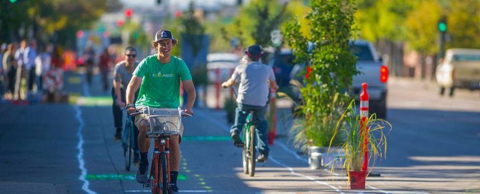
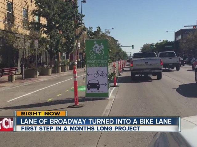
3 move people, not just vehicles, by providing multimodal improvements Broadway/Lincoln was identified as an Investment Corridor Strategic Transportation Plan 2008 Denver Moves 2011 unique character, complex traffic operations and ideal location as a primary north/south route for current and future bicycle needs


4 Denver Moves 2014 recommends Broadway as a protected bikeway from downtown to I recommends a two- way protected bikeway on the east side of Broadway as well as enhanced transit on the West side of the street

5 Broadway and Lincoln are in constant change

6 Broadway and Lincoln are in constant change

7 Broadway and Lincoln are in constant change

8 Broadway and Lincoln are in constant change

9 Broadway and Lincoln are in constant change
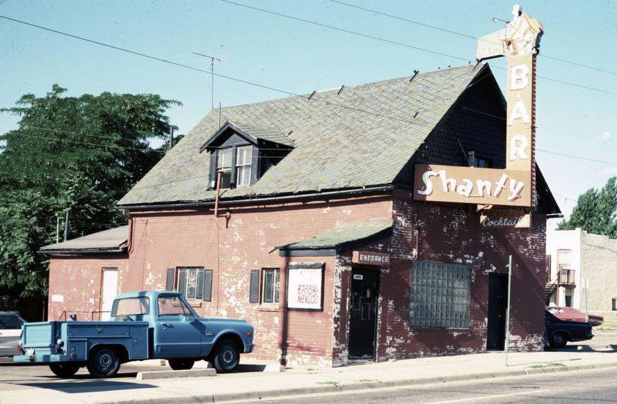
10 Broadway and Lincoln are in constant change Broadway and Lincoln are in constant change

11 Broadway and Lincoln are in constant change

12 Broadway and Lincoln are in constant change

13 Annual Change in Denver Popula on: 2006 to 2014 State Demography Office - Colorado 18, people per day! 680,000 16, ,000 14, ,000 12, ,000 10, ,000 8,000 6,000 11,466 13,670 16,098 13,926 14,034 14, , ,000 4,000 7,575 9, ,000 2, , , , , , , , , , , , ,000
14 MILLENNIALS increase in millennial population 11,207 11,988 3rd Nationally increase in millennial population 2nd Nationally increase in millennial population 23,195 1st Nationally U.S. Census 12 per day for the last 5 years!

15 Seattle: Other places are also in constant change


16 Philly: Other places are also in constant change


17 Indy: Other places are also in constant change


18 Pueblo: Other places are also in constant change
19

20 Door to Door Visits 3 days in October team members walked Discussed project goals Video interviews collected Outreach summary Interviewed 125 business 280 flyers distributed 82 follow up requests 215 residences received flyers

21 Businesses appreciated visits and want to stay involved

22 Businesses appreciated visits and want to stay involved

23 Businesses appreciated visits and want to stay involved

24 Talked with people walking, dining, and shopping

25 Talked with employees on their way to lunch

26 Talked with middle schools students waiting for RTD

27 Distributed flyers at all residences on the corridor
28 Bikes on Broadway Business owners/managers want to meet to discuss changes Business owners/managers have employees riding bikes to work Parking changes are paramount to business owners/managers Pedestrians on Broadway Business owners/managers identified intersection as challenges Fast moving traffic is not great for place making Transit on Broadway Employees are riding the buses to work Transit stop are not seen as an asset

29 Existing Conditions Data

30 BROADWAY Other Residential Office 1% 11% 10% 78% Retail/ Restaurant Existing Conditions Land Use windshield survey august % LINCOLN Other 80% Retail/Restaurant Office 15% 2% Residential

31 BROADWAY Medium Other Use 12% High Use Existing windshield survey Conditions august 2015 Business Land Use of UseSidewalk No Use 14% 100% 74% sale between speer and I-25 september 2015 LINCOLN Other No Use

32 BROADWAY Other 26 Benches and Shelters Existing Conditions Street Land Furnishings Use between speer and I-25 september 2015 LINCOLN Other 1 Benches and Shelters

33 BROADWAY Other $5.5 million sales tax Existing Conditions Land Use LINCOLN Other $850,000 sales tax 46% increase 2010 to % increase 2010 to 2014

34 BROADWAY Other Existing Conditions Transit Land Stop Use Activity between 6th and alameda march 2013 LINCOLN Other 1,825 1,987 1,852 2,629 Boardings Alightings january 2015 weekday 14th to exposition Boardings Alightings

35 BROADWAY Boardings Alightings Other 33,264 Vehicles per Day Existing Conditions Vehicle Land Volume Use south of 6th avenue september 2014 LINCOLN Boardings Alightings Other 27,569 Vehicles per Day


36 Lincoln: 7:30 AM to 8:30 AM Spring 2015 on a Tuesday 675 1,


37 Broadway: 5:30 PM to 6:30 PM Spring 2015 on a Tuesday
38 Vehicles per Day BROADWAY Other AM NOON PM Existing Conditions Vehicle Land Travel Use Time Colfax to I-25 I-25 to Colfax 6m 37s 7m 1s 12m 36s peak period travel time september 2015 Vehicles per Day LINCOLN Other AM NOON PM 10m 32s 8m 6s 13m 1s
39 Vehicle Travel Time 15% AM increase since 2011 peak period travel time september % AM increase since % PM increase since % PM increase since to 18 minutes 11 to 22 minutes Colfax to I25 I25 to Colfax BROADWAY Existing Conditions LINCOLN

40 12m 36s BROADWAY Existing Conditions Vehicle Land Speed Use 13m 1s North End South End North End South End YOUR SPEED 31 Other YOUR SPEED LINCOLN Other YOUR SPEED cleveland place center avenue 13th avenue dakota avenue average mean speed YOUR SPEED 38
41 Speeding during off- peak hours Dakota AM peak Daily Travel Speeds PM peak 40 Miles per Hour Thursday 6/4 10 0
42 Consistent low speeds most of the day 13th Daily Travel Speeds AM peak PM peak 25 Miles per Hour Thursday 6/
43 Consistent speeds above speed limit Center Daily Travel Speeds AM peak PM peak Miles per Hour Tuesday 5/
44 Decreasing speeds during most of day Cleveland AM peak Daily Travel Speeds PM peak Miles per Hour Tuesday 2/

45 BROADWAY 6AM 7PM 9PM Other 1% occupied 75% occupied 76% occupied Existing Conditions Parking Land Utilization Use between 6th and alameda march 2013 Other 6AM 7PM 9PM Residential LINCOLN 11% occupied 49% occupied 79% occupied

46 BROADWAY Pedestrian Other 6% 89% Bicycle Vehicles Existing Conditions Collisions Land Use 5% Pedestrian Other Bicycle 1,662 total crashes ,245 total crashes 3% LINCOLN 95% 2% Vehicles


47 People are riding on Broadway

48 BROADWAY Other 80 People on Bicycles Existing Conditions Bicycle Land Volume Use total at 13th avenue for am, noon, and pm peaks september 2015 LINCOLN Other 55 People on Bicycles

49 BROADWAY Travel Lane Other 5% Existing Conditions Bicycle Land Riding Use Location LINCOLN Other 9% Travel Lane Bus Lane 26% 69% Sidewalk Bus Lane 42% 49% Sidewalk at 13th avenue am, noon, pm peaks september 2015

50 BROADWAY Other Males Females 83% 17% Existing Conditions Bicyclist Land Demographic Use at 13th avenue am, noon, pm peaks september 2015 LINCOLN Other Males Females 87% 13% at 13th avenue am, noon, pm peaks september 2015
51 Explored 10 Variations for the Broadway Corridor Protected bike lanes One- way SB on Broadway Two- way separated using contraflow Shared bus/bike lane Parking protected Buffer protected (painted/median) Shared SB with NB contra flow Two- way cycle- track Golden Triangle Plan Westside variation Protected transit lane with cycle- track

52 Explored 10 Variations for the Lincoln Corridor Parking protected bike lane Eastside parking Transit protected bike lane Eastside transit without parking Buffer planter protected No transit or parking Two- way cycle- track Shared bus/bike lane Multi- use path East or westside
53 Charrette Preliminary Screening Criteria Minimal number of travel lanes repurposed Minimal intersection signal control changes Reduces wrong way cycling or salmoning Has protection for people riding bicycles Provides additional refuge for pedestrian crossings Minimizes the loss of parking spaces
54 Option #1: Two- way cycle track Golden Triangle Concept - Just on Broadway Facing North Broadway Sidewalk Planting Parking Transit Travel Zone Lane Lane Travel Lane Travel Lane Parking Buffered Cycle Track Planting Zone Sidewalk
55 Option #2: Both Corridors Cycle Track on Broadway, Multi- Use Path on South Lincoln Broadway Facing North Sidewalk Planting Zone Parking Transit Lane Travel Lane Travel Lane Travel Lane Parking Cycle Track Planting Zone Sidewalk
 No Change Facing North 8 8 8 10 10 10 11 7 8 10 Sidewalk Planting Zone Parking Travel Lane Travel Lane Travel Lane")

56 Option #2: Both Corridors Cycle Track on Broadway, Multi- Use Path on South Lincoln Lincoln Street (7 th Ave to Colfax Ave) No Change Facing North Sidewalk Planting Zone Parking Travel Lane Travel Lane Travel Lane Managed Lane Parking Planting Zone Sidewalk (AM Transit) Lincoln Street (Exposition Ave to 3 rd Ave) Sidewalk Planting Zone Travel Lane Travel Lane Travel Lane Managed Lane / Planting Multi-use Off-Peak Parking Zone Path
57 Option #3: One- Way Cycle Track Directional bike lane in each corridor Broadway Facing North Sidewalk Planting Zone Parking Transit Lane Travel Lane Travel Lane Travel Lane Parking Protected Bike Lane Planting Zone Sidewalk
 Zone Lincoln Street (South End) 5 13 6 6 10 10 12 13 5 Sidewalk Planting Bike Lane Buffer Travel Lane Travel Lane Managed Lane Planting")
58 Option #3: One- Way Cycle Track Directional bike lane in each corridor Lincoln Street (North End) Facing North Sidewalk Planting Zone Protected Bike Lane Parking Travel Lane Travel Lane Managed Lane Parking Planting Sidewalk (AM Transit) Zone Lincoln Street (South End) Sidewalk Planting Bike Lane Buffer Travel Lane Travel Lane Managed Lane Planting Sidewalk Zone Off-Peak Parking Zone
59 BROADWAY/LINCOLN CORRIDOR STUDY Preliminary Concept Evaluation Goal 1: Improve Safety in the Corridor No Change (Existing) Option 1 Two-Way Cycle Track (Broadway) Option 2 Two-Way Cycle Track (Lincoln) Option 3 One-Way Cycle Tracks (Broadway & Lincoln) Provides separation for people walking and bicycling Provides separation between people walking and driving Improves visibility at intersections Predictable driving and cycling behavior Reduces pedestrian crossing distance Goal 2: Make a More Livable Corridor Provides separation for people walking and bicycling Supports placemaking & neighborhood character Minimizes parking and loading zone impacts Encourages driving speeds at posted limit Supports economic vitality in the corridor Goal 3: Improve Mobility for All Provides separation for people walking and bicycling Maintains travel time for people driving Predictable driving and cycling behavior Minimizes parking and loading zone impacts Feasible implementation/cost Yes Maybe No
Welcome to the Quebec Alternatives Analysis Public Meeting
 Welcome to the Public Meeting Please sign in. Public Comment Please fill out a comment card and tell us what you think. Check back or comment any time at: www.quebecalternatives.com Project Area Technical
Bellevue Downtown Association Downtown Bike Series
 Bellevue Downtown Association Downtown Bike Series Meeting 2 Franz Loewenherz Andreas Piller Kyle Potuzak Chris Long October 26, 2017 Today s Agenda: 1) Meeting Purpose 2) 9/28 Meeting Recap 3) Candidate
City of Wilsonville 5 th Street to Kinsman Road Extension Project
 City of Wilsonville 5 th Street to Kinsman Road Walking Tour & Neighborhood Workshop Summary Report Public Outreach Overview On July 18 th, 2017, the City of Wilsonville hosted a neighborhood walking tour
Technical Working Group November 15, 2017
 Technical Working Group November 15, 2017 Welcome and Introductions Project Partners Regional Transportation District (RTD) Colorado Department of Transportation (CDOT) Denver Regional Council of Governments
Community Task Force July 25, 2017
 Community Task Force July 25, 2017 Welcome and Introductions Project Partners Regional Transportation District (RTD) Colorado Department of Transportation (CDOT) Denver Regional Council of Governments
Eliminate on-street parking where it will allow for a dedicated bus only lane %
 Traffic Dashboard Priorities Survey Responses Introduction 1) Are you familiar with bus rapid transit (BRT)? a. No, BRT is new to me. 597 23.5% b. I ve heard of BRT, but I don t know much about it. 1,136
Community Task Force November 15, 2017
 Community Task Force November 15, 2017 Welcome and Introductions Project Partners Regional Transportation District (RTD) Colorado Department of Transportation (CDOT) Denver Regional Council of Governments
COWETA HIGH SCHOOL AND EAST HIGHWAY 51
 COWETA HIGH SCHOOL AND EAST HIGHWAY 51 Lack of sidewalks along Ben Lumpkin Rd. Lack of crosswalks and ramps at intersection. Hwy 51 is wide to cross as a pedestrian. No ADA compliance or connection to
25th Avenue Road Diet Project A One Year Evaluation. Transportation Fund for Clean Air Project #05R07
 25th Avenue Road Diet Project A One Year Evaluation Transportation Fund for Clean Air Project #05R07 Submitted by: The San Francisco Municipal Transportation Agency Dan Provence May 22, 2009 EXECUTIVE
BROADWAY/LINCOLN CORRIDOR STUDY PHASE 2. RELEASED May Bikeway Evaluation. Data Summary: August - November 2016
 BROADWAY/LINCOLN CORRIDOR STUDY PHASE 2 Bikeway Evaluation Data Summary: August - November 2016 RELEASED May 2017 Acknowledgments Mayor Michael B. Hancock City Council District 7 Representative Jolon
Downtown Naples Mobility and Connectivity Study. Naples City Council Presentation January 2017
 Downtown Naples Mobility and Connectivity Study Naples City Council Presentation January 2017 Agenda 1. Introduction 2. Scope Review 3. Project Schedule 4. Existing Conditions 5. Public Charrette 6. Mobility
A CHANGING CITY. of Edmonton, it is essential that it reflects the long-term vision of the City.
 A CHANGING CITY By the year 2040, Edmonton will be home to more than 1 million people. To accommodate growth and support a healthy and compact city, we need a new approach to development/redevelopment
NACTO Designing Cities 2014 Dongho Chang, City Traffic Engineer October 23, 2014
 NACTO Designing Cities 2014 Dongho Chang, City Traffic Engineer October 23, 2014 Presentation overview Perspective on Safety Changing needs of our cities How Seattle is meeting those needs Challenge for
HARRISON STREET/OAKLAND AVENUE COMMUNITY TRANSPORTATION PLAN
 HARRISON STREET/OAKLAND AVENUE Community Workshop #4: Draft Plan Review December 3, 2009 D E S I G N, C O M M U N I T Y & E N V I R O N M E N T INTRODUCTIONS Key Project Staff: Alisa Shen, Project Manager,
Southview Blvd & 3 rd Avenue Improvement Project. Public Open House December 4, to 7pm
 Southview Blvd & 3 rd Avenue Improvement Project Public Open House December 4, 2014 5 to 7pm Southview Blvd & 3 rd Avenue Public Information Meeting Agenda Presentation 5:30 to 6:15 pm Purpose of Project
Public Workshop #2. September 14, 2016
 Public Workshop #2 September 14, 2016 Agenda Welcome Project Overview Where We Have Been Alternatives for State Street Land Use Street Design Next Steps 2 Project Overview Create a Vibrant State Street
Community Task Force March 14, 2018
 Community Task Force March 14, 2018 Welcome and Introductions Project Partners Regional Transportation District (RTD) City of Aurora Colorado Department of Transportation (CDOT) Denver Regional Council
FLETCHER AVENUE PEDESTRIAN AND BICYCLIST BEHAVIOR CHANGE FORMATIVE RESEARCH PROJECT
 FLETCHER AVENUE PEDESTRIAN AND BICYCLIST BEHAVIOR CHANGE FORMATIVE RESEARCH PROJECT EXTENT OF CHANGES IN PEDESTRIAN AND BICYCLIST ATTITUDES AND BEHAVIORS DIRECTLY AFTER A COMPLETE STREETS PROJECT IN FLORIDA
Chapter 14 PARLIER RELATIONSHIP TO CITY PLANS AND POLICIES. Recommendations to Improve Pedestrian Safety in the City of Parlier (2014)
") Chapter 14 PARLIER This chapter describes the current status and future plans for biking and walking in the City of Parlier. RELATIONSHIP TO CITY PLANS AND POLICIES The Parlier General Plan is the primary
Chapter 14 PARLIER This chapter describes the current status and future plans for biking and walking in the City of Parlier. RELATIONSHIP TO CITY PLANS AND POLICIES The Parlier General Plan is the primary
Thank you for attending
 Improving mobility safety comfort WELCOME Thank you for attending The purpose of this meeting is to: Learn about the project Prioritize potential walking and biking improvements on Snelling Ave Gather
Bus Rapid Transit Plans
 Twin Cities Region Bus Rapid Transit Plans ULI Minnesota Workshop Connecting Bus Rapid Transit to the Community December 15, 2009 John Levin Director of Service Development Metro Transit Metropolitan Area
Omaha s Complete Streets Policy
 Omaha s Complete Streets Policy (Adopted August 2015) VISION To create great places and enhance our quality of life, the City of Omaha will provide safe, accessible streets for all users. Complete Streets
EXECUTIVE SUMMARY. Vision
 Vision Walking and bicycling in Salt Lake City will be safe, convenient, comfortable, and viable transportation options that connect people to places, foster recreational and economic development opportunities,
Instructions for Counting Pedestrians at Intersections. September 2014
 Instructions for Counting Pedestrians at Intersections September 2014 Purpose This document introduces the concept of the pedestrian count and provides instructions for performing a manual intersection
Richmond-Adelaide Cycle Tracks
 Public Drop-In Event Richmond-Adelaide Cycle Tracks June 25, 2018 12:00 p.m. 3:00 p.m. 4:30 p.m. 7:30 p.m. Metro Hall, Rotunda 55 John Street 1 Purpose of Event In Scope Communicate an update about the
El Camino Real Specific Plan. TAC/CAC Meeting #2 Aug 1, 2018
 El Camino Real Specific Plan TAC/CAC Meeting #2 Aug 1, 2018 Land Use Alternatives Goals and Tradeoffs Parks & open space Housing Retail & services Civic spaces Parking Community gathering spaces 3 Alternatives
MASONIC AVENUE STREET DESIGN STUDY Community Workshop 2. Masonic Ave Street Design Study Community Workshop 2 August 10, 2010
 Masonic Ave Street Design Study Community Workshop 2 August 10, 2010 Introduction MASONIC AVENUE STREET DESIGN STUDY Community Workshop 2 SF Municipal Transportation Agency Javad Mirabdal, Project Manager
Plant City Walk-Bike Plan
 Plant City Walk-Bike Plan Plant City Commute Mode Share 2.2% 1.4% 2.9% Drove alone 10.2% Carpooled Public transportation (0.1%) Walked Used a Bike (0.4%) 82.9% Taxicab, motorcycle, or other means Worked
San Jose Transportation Policy
 San Jose Transportation Policy Protected Intersections in LOS Policies to Support Smart Growth Presented by: Manuel Pineda City of San Jose Department of Transportation Bay Area Map San Francisco Oakland
CHAPTER 3: Vision Statement and Goals
 Davidson Walks & Rolls: Active Transportation Master Plan CHAPTER 3 Contents: Overview Vision Statement Measurable Goals Public Outreach CHAPTER 3: Vision Statement and Goals Overview The vision statement
Major Bike Routes 102 Avenue Workshop April 21, 2015
 Major Bike Routes 102 Avenue Workshop April 21, 2015 Our Purpose Today Provide context on how Major Bike Routes fit into Edmonton s future Share information on what we heard in our last phase, and how
About the study. North Milwaukee Ave. Key goals of this study are to: Achieve Vision Zero* by. Harmonize the space and improve walkability
 About the study Key goals of this study are to: North Milwaukee Avenue is a local and regional street for multiple modes of transportation. It is officially zoned and functions as a pedestrian street southeast
Performance Criteria for 2035 Long Range Transportation Plan
 Minimizing Impacts on Natural, Historic, Cultural or Archeological Resources 2035 LRTP Weighting Factor: 7% Objective 1.1: Use appropriate planning and design criteria to protect and enhance the built
Bikeway action plan. Bicycle Friendly Community Workshop March 5, 2007 Rochester, MN
 Bikeway action plan Summary The was held on March 5, 2007 at the Rochester Mayo Civic Center. The workshop was hosted by Rochester-Olmsted County Planning Department in collaboration with the League of
Hennepin Avenue Reconstruction Washington Avenue to 12 th Street
 CITY OF MINNEAPOLIS Hennepin Avenue Reconstruction Washington Avenue to 12 th Street April 2016 1 Upcoming Opportunities Public Meeting #2 April 25, 2016 Minneapolis Central Library Doty Board Room Repeat
BICYCLE FACILITIES FULL BUILD PLAN
 KIMBALL RD ROCKY RD CYPRESS DR CITY PARK AVE S SHIELDS ST CONSTITUTION AVE S TAFT HILL RD S OVERLAND TRL HILLCREST DR SKYLINE DR MOBY DR CRAGMORE DR CASTLEROCK DR MEADOWBROOK DR S BRYAN AVE BICYCLE FACILITIES
RapidRide Roosevelt Seat Sea t t le t le Depa De r pa t r men men t of Sept T an r sp an or sp t or a t t a ion
 RapidRide Roosevelt Seattle Bicycle Advisory Board 1 Our mission, vision, and core values Mission: deliver a high-quality transportation system for Seattle Vision: connected people, places, and products
Metro Bike/Bus Interface Study
 Metro Bike/Bus Interface Study Agenda 1. Background & Process 2. Corridors & Metrics 3. General Findings 4. Training Recommendations 5. Design Guidelines 6. Questions L.A. County Bus Service LA Metro 1,433
Monterey Road Complete Streets
 Monterey Road Complete Streets Complete Street Objectives Improve livability and economic vitality Enhance pedestrian environment Accommodate bicyclists safely Reduce noise and air pollution Create attractive,
Update on Regional Bicycle, Pedestrian, & Trail Planning. Presented to TCC November 21, 2014
 Update on Regional Bicycle, Pedestrian, & Trail Planning Presented to TCC November 21, 2014 Survey Measure Assess Focus Area Performance- Driven Process Policy Policy Implement Plan Criteria Criteria Criteria
Route 79/Davol Street Corridor Study
 Route 79/Davol Street Corridor Study Fall River, MA Public Information Meeting #2 November 21, 2013 Fall River Heritage State Park Fall River, MA Agenda Welcome and Introductions Overview of Study Process
Bicycle Crashes. Number of Bike Crashes. Total Bike Crashes. are down 21% and severe bike crashes down 8% since 2013 (5 years).
.") Bicycle Crashes The City of Fort Collins is well known for its bike culture, and there is a strong focus on encouraging increased riding. Bike safety is an important component of supporting these efforts.
Bicycle Crashes The City of Fort Collins is well known for its bike culture, and there is a strong focus on encouraging increased riding. Bike safety is an important component of supporting these efforts.
MEMORANDUM. Charlotte Fleetwood, Transportation Planner
 MEMORANDUM Date: Updated August 22, 2017 To: Organization: Charlotte Fleetwood, Transportation Planner Boston Transportation Department From: Jason DeGray, P.E., PTOE, Regional Director of Engineering
Completing the Street: Denning Drive
 Completing the Street: Denning Drive Public Workshop and Walking Audit Winter Park Civic Center May 12, 2016 Completing the Street What Makes This a Complete Street? Completing the Street Complete Streets
Dear Mr. Tweed: Sincerely, Min Zhou, P.E. Vice President
 December 17, 2012 Mr. Steve Tweed City of Long Beach, Department of Public Works Traffic & Transportation Bureau, 10 th Floor City Hall 333 West Ocean Boulevard Long Beach, CA 90802 Subject: Broadway and
City of Birmingham Draft Multi-modal Transportation Plan
 City of Birmingham Draft Multi-modal Transportation Plan City Commission Public Hearing Monday, November 25, 2013 7:30 pm Norman Cox, PLA, ASLA The Greenway Collaborative, Inc. Ann Arbor, Michigan The
El Paso County 2040 Major Transportation Corridors Plan
 El Paso County 2040 Major Transportation Corridors Plan Connect-our-County Online Transportation User Survey Preliminary Results June 24, 2010 Years of Residence 2. How many years have you LIVED HERE?
Cherry Creek Transportation and Land Use Forum September 25, 2013 Meeting Summary
 Cherry Creek Transportation and Land Use Forum September 25, 2013 Meeting Summary I. LEAD-IN TO SMALL GROUP DISCUSSION, POLLING AND STEERING COMMITTEE/TECHNICAL TASK FORCE DISCUSSION The meeting began
City of Seattle Edward B. Murray, Mayor
 City of Seattle Edward B. Murray, Mayor Department of Transportation Scott Kubly, Director Eastlake Community Council 117 E Louisa St. #1 Seattle, WA 98102-3278 January 28, 2016 RE: Roosevelt to Downtown
Laurier Segregated Bike Lane Pilot Project July 2013 update
 Laurier Segregated Bike Lane Pilot Project July 2013 update Presentation Overview Background Pilot Monitoring Results Mitigation Recommendations Next Steps Laurier 2 Background Laurier Avenue Segregated
Vision: Traditional hamlet with an attractive business/pedestrian friendly main street connected to adjacent walkable neighborhoods
 N D. Focus Area II Vision: Traditional hamlet with an attractive business/pedestrian friendly main street connected to adjacent walkable neighborhoods Transit Road Focus Area II is located in the Hamlet
ITE Northeastern District Meeting
 West Hartford Road Diet and Safety Study ITE Northeastern District Meeting Session 2A Complete Streets May 22, 2018 North Main St. - Classified as a principal arterial But provides high levels of access
COMPLETE STREETS PLANNER S PORTFOLIO
 COMPLETE STREETS PLANNER S PORTFOLIO ISSUE 3 APRIL 2016 PLANNER S PORTFOLIO COMPLETE STREETS 1 2 6 10 14 OVERVIEW MATURE NEIGHBORHOODS GROWING SUBURBS CENTRAL PLACES ACTIVITY CORRIDORS Planner s Portfolio
Safer Cycling: How the City of Vancouver is Proactively Improving Cycling Safety
 Safer Cycling: How the City of Vancouver is Proactively Improving Cycling Safety Brian Patterson, MCIP, RPP Urban Systems 2015 Canadian Association of Road Safety Professionals (CARSP) Conference Session
Stakeholder Update. Agenda. Project update Needs Identification Strategy Proposed needs Safety Collectors/Arterials Greenways Local roads
 1 Stakeholder Update May 21, 2018 2 Agenda Project update Needs Identification Strategy Proposed needs Safety Collectors/Arterials Greenways Local roads Proposed Evaluation Criteria Next Steps 1 Project/Schedule
WELCOME Mission-Geneva Transportation Study
 WELCOME Mission-Geneva Transportation Study Study Process and Schedule 2005 2006 Oct Nov Dec Jan Feb Mar Apr May Jun Jul Aug Sept Oct Task 2 Develop Outreach Plan Task 3 Document Existing Conditions/ Prioritize
Project Kickoff Meeting February 15, 2018
 Project Kickoff Meeting February 15, 2018 Scope of Work: Study Area Project Goals Develop traffic calming alternatives to the Vine Street local right of way, to mitigate speeding. Develop concept plans
SPEED MANAGEMENT FOR VISION ZERO
 SPEED MANAGEMENT FOR VISION ZERO LUANN HAMILTON, DEPUTY COMMISSIONER FOR PROJECT DEVELOPMENT CHICAGO DEPARTMENT OF TRANSPORTATION NACTO DESIGNING CITIES 2017 Vision Zero Action Plan Speed management and
Uniting Cleveland through the Euclid Corridor Transportation Project
 Zhang 1 Uniting Cleveland through the Euclid Corridor Transportation Project Jinmeng Zhang As a bus passenger takes a ride to downtown Cleveland through Euclid Avenue, constructions can be seen along the
Protected Bike Lanes in San Francisco Mike Sallaberry SFMTA NACTO Workshop - Chicago IL
 Protected Bike Lanes in San Francisco Mike Sallaberry SFMTA 10 14 2011 NACTO Workshop - Chicago IL San Francisco 2 nd Highest Density in the U.S. 47 square miles Mild Climate Market Population ~810,000
Project Goals Project Limits Boston Bikes Data Existing Conditions Proposed Options Discussion
 COMMERCIAL STREET/ ATLANTIC AVENUE BICYCLE FACILITIES Toole Design Group Nick Jackson Michelle Langone Danila, P.E., PTOE April 28, 2011 Presentation Outline Project Goals Project Limits Boston Bikes Data
Polk Streetscape Project
 What is this project? The Polk Streetscape Project is an effort to improve safety for everyone traveling on Polk Street between Union and McAllister streets. Also included in this project are paving, sewer
Arterial Transitway Corridors Study. Ave
 Arterial Transitway Corridors Study Ave January 2012 Arterial Transitway Corridors Study Overview Corridor Features and Demographics 11 study corridors, 95 route miles 86,000 daily rides and half of existing
INNER LOOP EAST. AIA Rochester Annual Meeting November 13, 2013 TRANSFORMATION PROJECT. Bret Garwood, NBD Erik Frisch, DES
 INNER LOOP EAST TRANSFORMATION PROJECT AIA Rochester Annual Meeting November 13, 2013 Bret Garwood, NBD Erik Frisch, DES Why? We are building a city that encourages walking, biking and enjoying the outdoor
Community Task Force October 5, 2017
 Community Task Force October 5, 2017 Welcome and Introductions Project Partners Regional Transportation District (RTD) Colorado Department of Transportation (CDOT) Denver Regional Council of Governments
Dr. M.L. King, Jr. Street North Complete Streets Resurfacing Opportunities HOUSING, LAND USE, AND TRANSPORTATION COMMITTEE MARCH 22, 2018
 Dr. M.L. King, Jr. Street North Complete Streets Resurfacing Opportunities HOUSING, LAND USE, AND TRANSPORTATION COMMITTEE MARCH 22, 2018 What s Happening The City plans to mill and resurface Dr. M.L.
North Avenue Corridor Study
 North Avenue Corridor Study City Council October 6, 2014 Presentation Outline Project Initiation & Process Corridor Conditions & Issues Vision & Goals Concept Development - Development/Evaluation Implementation
BETHEL ROAD AND SEDGWICK ROAD CORRIDOR STUDY
 DRAFT PLAN City Council Meeting August 14, 2017 STUDY AREA Sedgwick Corridor State Route 160, principal arterial with Class 3 access management designation, commuter and freight route, connection to SR
TRANSPORTATION COMMISSION Agenda Staff Report
 TRANSPORTATION COMMISSION Agenda Staff Report Agenda Item No. 5.a DATE: JULY 31, 2014 TO: FROM: SUBJECT: TRANSPORTATION COMMISSION COMMUNITY DEVELOPMENT DEPARTMENT - PLANNING DRAFT OLYMPIC CORRIDOR PREFERRED
Bicycle and Pedestrian Advisory Committee (BPAC) November 21, 2013
 November 21, 2013") Bicycle and Pedestrian Advisory Committee (BPAC) November 21, 2013 OVERALL LAND USE CONCEPT Overall Broadway Valdez District: 95.5 acres (35.1 acres right-of ways + 60.4 acres developable land) Plan Subareas:
Bicycle and Pedestrian Advisory Committee (BPAC) November 21, 2013 OVERALL LAND USE CONCEPT Overall Broadway Valdez District: 95.5 acres (35.1 acres right-of ways + 60.4 acres developable land) Plan Subareas:
MAYFIELD ROAD CORRIDOR MULTIMODAL TRANSPORTATION PLAN. Public Workshop
 MAYFIELD ROAD CORRIDOR MULTIMODAL TRANSPORTATION PLAN Public Workshop 06.06.18 AGENDA Project Process & Schedule Document Review Summary Project Goals Initial Findings Concept Development Next Steps PROJECT
Board of Supervisors February 27, 2017
 : Traffic Analysis Results & Draft Conceptual Plan Board of Supervisors February 27, 2017 Transportation Solutions Building Better Communities Presentation Overview Background Summary of Traffic Analysis
Los Altos Hills Town Council - June 18, 2015 Palo Alto City Council June 22, AGENDA ITEM #2.B Presentation
 Los Altos Hills Town Council - June 18, 2015 Palo Alto City Council June 22, 2015 AGENDA ITEM #2.B Presentation Previous Presentations Los Altos Hills Town Council in May 2014 and February 2015 Palo Alto
2014/2015 BIKE ROUTE PLAN 83 AVENUE PROTECTED BIKE LANE
 About the Project 2014/2015 BIKE ROUTE PLAN The City of Edmonton is planning a major bike route on the south side of Edmonton. This bike route is one part of a plan to provide citizens with transportation
THE ALAMEDA CONCEPT DESIGN COMMUNITY MEETING 3. A Plan for The Beautiful Way JANUARY 28, 2010
 CONCEPT DESIGN COMMUNITY MEETING 3 JANUARY 28, 2010 AGENDA INTRODUCTION COMMUNITY INPUT ROADWAY STUDIES STREETSCAPE DESIGN STATIONS DISCUSSION SUMMARY AND DISCUSSION NEXT STEPS CLOSE INTRODUCTION SCHEDULE
UPTOWN REGIONAL BIKE CORRIDORS PROJECT SAN DIEGO ASSOCIATION OF GOVERNMENTS
 UPTOWN REGIONAL BIKE CORRIDORS PROJECT SAN DIEGO ASSOCIATION OF GOVERNMENTS SUMMARY REPORT: COMMUNITY UPDATE MEETING February 6, 2014 6 8:30 p.m. Roosevelt Middle School Library 3366 Park Blvd, San Diego
Community Meeting February 27, 2007 Dorchester Avenue Transportation & Streetscape Improvements Action Plan February 27, 2007
 Community Meeting Tonight s Agenda 6:00 Introductions South Boston/Dot Ave Improvement Study Background 6:15 Consultant Introductions Review of Scope and Schedule Review of Proposed Corridor Wide Guidelines
9/25/2018. Multi-Modal Level of Service (MMLOS) Bianca Popescu, Transportation Planner
 Bianca Popescu, Transportation Planner") Multi-Modal Level of Service (MMLOS) Bianca Popescu, Transportation Planner 1 What is MMLOS? Is this a nice place to walk? Is this a nice place to bike? Is transit convenient? Bottom line - Are there options
Multi-Modal Level of Service (MMLOS) Bianca Popescu, Transportation Planner 1 What is MMLOS? Is this a nice place to walk? Is this a nice place to bike? Is transit convenient? Bottom line - Are there options
Greater Cleveland Regional Transit Authority
 Greater Cleveland Regional Transit Authority Transit Priority Corridor Initiatives West 25 th Street /East 105 th /East 93 rd Streets June 20, 2017 Presented to: Planning & Development Committee Greater
Report. Typical Sections. City of Middleton, WI
 Report Typical Sections City of Middleton, WI December 2006 Report for City of Middleton, Wisconsin Typical Sections repared by: Traffic Associates LLC and STRAND ASSOCIATES, INC. 910 West Wingra Drive
FOURTH PLAIN BOULEVARD RE-STRIPING PROJECT. Post Implementation Report 1.2. Transportation Services. October 2004 DEMONSTRATION
 FOURTH PLAIN BOULEVARD DEMONSTRATION RE-STRIPING PROJECT Post Implementation Report 1.2 October 2004 Transportation Services Table of Contents GENERAL INTRODUCTION 1 PROJECT BACKGROUND 1 PURPOSE OF 3-LANE
FEDERAL HIGHWAY ADMINISTRATION APPLICATION
 FEDERAL HIGHWAY ADMINISTRATION APPLICATION REQUEST FOR PERMISSION TO EXPERIMENT WITH A BICYCLE BOX INTERSECTION TREATMENT Submitted by: City of Columbus Department of Public Service Date: June 26, 2009
Sixth Line Development - Transit Facilities Plan
 Memorandum Date: November 13, 2012 To: From: c.c. Subject: Rob Freeman (Freeman Planning) Kevin Phillips Sixth Line Development - Transit Facilities Plan 33016631 This memo was prepared to review the transit
TRANSPORTATION NEEDS ASSESSMENT
 TRANSPORTATION NEEDS ASSESSMENT A travel demand analysis was carried out to determine the operational issues and the potential benefit that adding traffic capacity would have on the road network. All the
MASONIC AVENUE STREET DESIGN STUDY Community Workshop 3. Masonic Ave Street Design Study Community Workshop 3 September 30, 2010
 Masonic Ave Street Design Study Community Workshop 3 September 30, 2010 Introduction MASONIC AVENUE STREET DESIGN STUDY Community Workshop 3 SF Municipal Transportation Agency Javad Mirabdal, Project Manager
Data Analysis February to March Identified safety needs from reported collisions and existing travel patterns.
 Welcome! Thank you for participating in today s Valencia Bikeway Improvements workshop. Data Analysis February to March Identified safety needs from reported collisions and existing travel patterns. Initial
Complete Streets Chicago: Data Driven Design. Luann Hamilton Deputy Commissioner
 Complete Streets Chicago: Data Driven Design Luann Hamilton Deputy Commissioner AGENDA Chicago s goals Complete Streets & Sustainable Infrastructure Guides Data-Driven Planning Setting goals Scoping/research
National Bicycle and Pedestrian Documentation Project INSTRUCTIONS
 National Bicycle and Pedestrian Documentation Project INSTRUCTIONS The National Documentation Project (NBPD) is an annual bicycle and pedestrian count and survey effort sponsored by the Institute of Transportation
2018 Pedestrian and Bicycle and Safe Routes to School Application for Funding Page 1 of 31
 2018 Pedestrian and Bicycle and Safe Routes to School Application for Funding Page 1 of 31 2018 Pedestrian and Bicycle and Safe Routes to School Application for Funding Part 1: General Information Funding
City of San Diego Vision Zero Draft Strategic Plan FY 2017
 City of San Diego Vision Zero Draft Strategic Plan FY 2017 Engineering Objective: To develop and implement a strategy that employs best planning, design and engineering practices. Background: Over the
Welcome. If you have any questions or comments on the project, please contact:
 Welcome This drop-in public open house is intended to provide information about the Bay Street bike lanes project. This project proposes a dedicated cycling facility along Bay Street between Aberdeen Avenue
Pedestrian Mobility and Safety Audit Phoenix, AZ, USA. Executive Summary
 Phoenix, AZ, USA Executive Summary AARP and the Institute of Transportation Engineers (ITE) joined together in a pilot project to evaluate the accessibility and safety of five intersections in Phoenix,
Driverless Vehicles Potential Influence on Bicyclist Facility Preferences
 Driverless Vehicles Potential Influence on Bicyclist Facility Preferences MICHAEL BLAU, MCRP, LCI O T E C O C T O B E R 2 6, 2 0 1 6 S E S S I O N # 8 2 - E V A L U AT I N G T H E P E R F O R M A N C E
MAKE YOUR PLACE IN CHANNELSIDE
 MAKE YOUR PLACE IN CHANNELSIDE INTRODUCTION PROJECT LIMITS Channelside Drive from Cumberland Ave to Kennedy Boulevard EXISTING CONDITIONS EXISTING CONDITIONS CHANNELSIDE DRIVE FROM E. CUMBERLAND AVENUE
The Transformation of Portland into a Two-Wheeled Mecca. Mia Birk, Principal, Alta Planning + Design
 The Transformation of Portland into a Two-Wheeled Mecca Mia Birk, Principal, Alta Planning + Design Development of Portland s Bikeway Network 1990 Early 1990s Infrastructure Growing Public Support Growing
Lessons Learned from Cycle Tracks (Class IV Bikeways) Design Practice
 Design Practice") Lessons Learned from Cycle Tracks (Class IV Bikeways) Design Practice By: Min Zhou, P.E., Principal/Vice President KOA Corporation 1 What is a Cycle Track (Class IV) TYPICAL BIKEWAY CLASSIFICATION CLASS
Lessons Learned from Cycle Tracks (Class IV Bikeways) Design Practice By: Min Zhou, P.E., Principal/Vice President KOA Corporation 1 What is a Cycle Track (Class IV) TYPICAL BIKEWAY CLASSIFICATION CLASS
Presentation to the City of Ottawa Transit Commission. February 20, 2013
 Presentation to the City of Ottawa Transit Commission February 20, 2013 Background 1994: Comprehensive development plan for road networks and public transit(sto, MTQ,NCCandCUO) 1994: Commuter train study
Seattle Bicycle Advisory Board August 3, 2011
 First Hill Streetcar Project Seattle Bicycle Advisory Board August 3, 2011 S teve Durrant Alta Planning + Des ign Mark Dorn UR S J im Peters DK S Context First Hill Cycle Track Key Strategies Segment 1
Telegraph Avenue Complete Streets DRAFT Recommendations. Oakland Public Works Department September 11 and 13, 2014 Open Houses
 Telegraph Avenue Complete Streets DRAFT Recommendations Oakland Public Works Department September 11 and 13, 2014 Open Houses Presentation Overview What are complete streets? What problem are we trying
Planning Guidance in the 2012 AASHTO Bike Guide
 Planning Guidance in the 2012 AASHTO Bike Guide Presentation by: RJ Eldridge Peter Lagerwey August 22, 2012 WEBINAR 2: PLANNING GUIDANCE IN THE 2012 AASHTO BIKE GUIDE Today s Webinar Significant Updates