BROADWAY/LINCOLN CORRIDOR STUDY PHASE 2. RELEASED May Bikeway Evaluation. Data Summary: August - November 2016
|
|
|
- Charleen O’Brien’
- 5 years ago
- Views:
Transcription


1 BROADWAY/LINCOLN CORRIDOR STUDY PHASE 2 Bikeway Evaluation Data Summary: August - November 2016 RELEASED May 2017

2
3 Acknowledgments Mayor Michael B. Hancock City Council District 7 Representative Jolon Clark Project Management Team Emily Snyder, Urban Mobility Manager Dan Raine, Project Manager Curt Upton, Community Planning and Development Scott Burton, Parking, City and County of Denver Lacy Bell, Regional Transportation District (RTD) Executive Steering Committee Crissy Fanganello, Director of Transportation Steve Hersey, Director of Traffic Operations Amy Rens, Senior Traffic Engineer Justin Schmitz, Traffic Engineer Special Thanks City and County of Denver Staff Bike Denver Walk Denver Bicycle Colorado South Broadway Merchants Association Over 500 businesses, community members, and commuters who provided feedback about the Bikeway Evaluation Project Team Molly Veldkamp, Project Manager, Fox Tuttle Hernandez Transportation Group Bill Fox, Fox Tuttle Hernandez Transportation Group Steve Tuttle, Fox Tuttle Hernandez Transportation Group Alicia Zimmerman, Fox Tuttle Hernandez Transportation Group Morgan Huber, Fox Tuttle Hernandez Transportation Group Marjorie Alexander, Two Hundred John Barden, Two Hundred Ben Davis, OnSight Jay Renkens, MIG, Inc. Mark De La Torre, MIG, Inc.


4
5 Table of Contents Chapter 1: Introducing the Broadway Bikeway... 2 Broadway Bikeway Design Features...3 Chapter 2: Evaluating the Bikeway... 5 Goal 1: Everyone arrives safely to their designation.. 11 Crashes by Mode & Type...11 Public Perception of Safety...11 People Driving in the Transit Lane...12 Bicycle Riding Location...12 Goal 2: Collaborate with the community & businesses 14 Business Input...15 Community Input...16 Commuter Input...17 Participation in Outreach Opportunities...18 Goal 3: Provide mobility options for everyone Vehicle Travel Times...20 Vehicle Travel Volumes...21 Parallel Corridor Traffic...22 Parking Space Utilization...22 Bicycle Volumes...23 Bicycle Demographics...23 Sidewalk Pedestrian Volumes...24 Conclusion...24 Chapter 3: Planning for What s Next Phase 2: Bikeway Evaluation Data Summary: August - November
6 Chapter 1: Introducing the Broadway Bikeway Chapter 1. Introducing the Broadway Bikeway Denver is growing. This growth is putting increased pressure on Denver s transportation system. The City and County of Denver (the City) has been setting policy direction to handle this change for over a decade, taking a multimodal approach of moving people. Broadway and Lincoln are changing as well. methods, with no major capital improvements required. The implementation and observation of the Broadway bikeway is helping the project team and the public learn about the operation of a two-way bikeway along a one-way street and will inform the design of a potential future corridor-long facility. In line with its philosophy for mobility, City plans have identified the importance of, and made recommendations for, the Broadway/Lincoln corridor. In line with its philosophy for mobility, City plans have identified the importance of, and made recommendations for, the Broadway/Lincoln corridor. Recommendations include the addition of a protected, two-way bikeway on Broadway, enhancement of the existing transit lane, pedestrian improvements, and cohesive parking management strategies. During Phase 1 of the Broadway/Lincoln Corridor Study, a two-way, parking-protected bikeway was identified as one of the potential projects to improve safety in the corridor, make the corridor more livable, and improve mobility for all users. As a first step toward implementing recommendations, the City decided to install a temporary bikeway on a segment of the Broadway corridor for Phase II (Bikeway Evaluation). This enabled operational evaluation of a bikeway and other mobility changes before making major infrastructure investments along the larger corridor. The Bikeway Evaluation is the initial step of planned mobility projects in the corridor. In August 2016, after six months of design and analysis, the City opened a two-way, parking-protected bikeway on a six-block segment of Broadway between Bayaud Avenue and Virginia Avenue. The City installed a long enough segment to collect meaningful data on operational impacts and utilized fiscally conservative Project Goals Everyone arrives safely to their destination Collaborate with the community and businesses Provide mobility options for everyone Data Collection August 2016 through November 2016 Online Survey Responses 240 total responses The figures on the opposing page show the crosssection of Broadway before and after the bikeway was installed. To create space for the bikeway, parking on the east side of Broadway was moved out from the curb, replacing the eastern-most travel lane. Three travel lanes were maintained, matching the three northbound travel lanes on Lincoln, the paired roadway in a one-way couplet. A striped buffer was painted between the parking lane and the two-way bikeway; flexible bollards were installed in the buffer. 2 Denver Moves Broadway/Lincoln Corridor Study


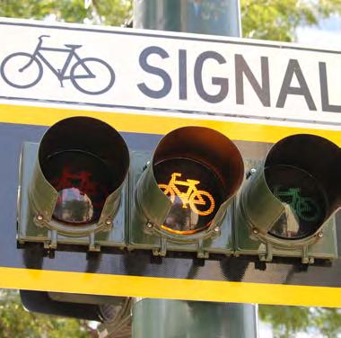
7 Chapter 1: Introducing the Broadway Bikeway BROADWAY BIKEWAY DESIGN FEATURES Broadway cross section before the Bikeway Broadway cross section after the Bikeway Many engineering design features were incorporated into the project to minimize conflicts between people riding bikes and people driving cars along Broadway. The design features were developed using guidance from the City s Bikeway Design Guidelines and national design guidelines. The the purpose of the Bikeway Evaluation was to study these features to understand how they affected Broadway and contributed to safe operations on the corridor. Green Paint at Conflict Zones: At driveways and intersections without a signal, green paint is used to signify an area where a higher degree of caution is necessary. It shows where motorists can cross the bikeway. Both bicyclists and motorists entering this area must exercise caution. Green has been approved by the U.S. Department of Transportation Federal Highway Administration for use in bikeways. Bicycle and Left Turn Signals: New bike signals, as well as automobile left turn pockets and left turn signals, were installed at Bayaud Avenue, Cedar Avenue, Alameda Avenue, and Virginia Avenue. The left turn signals prohibit people in cars from turning left when people riding bikes and walking are permitted to cross at intersections. The bike signals provide a red signal for people riding bicycles when people in cars are turning left across the bikeway. The bike signals also provide signal indication for people riding northbound on Broadway. Bike Signal at Cedar Avenue Phase 2: Bikeway Evaluation Data Summary: August - November


8 Chapter 1: Introducing the Broadway Bikeway Green pavement markings and sign with supplemental flasher at Maple Ave. Signs: Signs stating Left Turning Vehicles Yield to Bicycles are installed at intersections without traffic signals. Two-Way Bike Traffic signs are posted at driveways to remind drivers to look both ways for bikes before entering the roadway. Physical Barrier: The parking lane along the bikeway provides a physical barrier between people driving cars and people riding bikes or walking on the east side of the street. Painted buffers and flex posts provide physical separation where parking is not permitted. The reconfiguration moved traveling automobiles 10 feet further away from the sidewalk, which creates a more comfortable sidewalk for walking and enjoying the restaurants and shops along Broadway. Parking along the Bikeway 4 Denver Moves Broadway/Lincoln Corridor Study


9 Chapter 2: Evaluating the Bikeway Chapter 2. Evaluating the Bikeway The implementation and observation of the Broadway bikeway is helping the project team learn about the operation of a two-way bikeway along a one-way street and will inform the design of a potential future corridor-long facility. Before the installation of the bikeway, the project team worked with the City, stakeholders, and the general public to develop goals and identify evaluation criteria to be used to evaluate the success of the bikeway against those goals. As such, many avenues were provided for input. Community Meetings and Events: Prior to installing the bikeway, the City hosted popup meetings at Civic Center EATS downtown to alert commuters to the upcoming study on Broadway and at Illegal Pete s in the Broadway corridor to inform the community. Bike Denver and Bicycle Colorado hosted six events in the corridor to encourage people to visit the study area and provide feedback about the bikeway. Walk Denver also hosted an event to engage people in the study area. Business Meetings: The City attended Broadway Merchants Association Meetings, walked the corridor and went door-to-door to meet with business owners 12 times over the course of the project. Project Website: The project team hosted a website, DenverMovesBroadway.com, which shared information about the project, posted routine project updates, and hosted an online survey to gather input from the community, commuters, and businesses about their experience with the bikeway. Pop up event Through each of these avenues as well as s and phone calls, the City continues to receive support for the project, ideas and suggestions for improving the bikeway facility, and requests for extending the project into Downtown. The City has also received s expressing concerns about the bikeway, loss of parking and questions regarding signal operation. In addition, a few s requested the removal of the bikeway and end of the project due to perceived congestion. Reasons cited for these comments focused largely on the travel delay associated with waiting for the traffic signal to allow vehicles to turning left from Broadway. CCD Project Manager Dan Raine talking with a stakeholder in the study area. I love the new bike path! We are missing key North-South bike paths. I would love to see it extended up to Colfax and beyond Phase 2: Bikeway Evaluation Data Summary: August - November


10 Chapter 2: Evaluating the Bikeway Online Survey: An online survey was open from August 15, 2016 to November 30, During that time, 240 people responded to the survey. This is a great first step. We need a LOT more of this. Online Comments: The online comment portal that was opened during the Broadway/Lincoln Corridor Study remained open throughout the Bikeway Evaluation. Notices: The City used the stakeholders contact list collected throughout the project to provide information and encourage input about the bikeway. An project update sent in October 2016 Based on the identified goals and evaluation criteria shown in Figure 8, the project team collected performance measure data on the bikeway and Broadway corridor. Two data collection reporting periods were identified. First, the City collected data for three months after the bikeway was installed. This data was used to understand the preliminary impacts of the bikeway. Data was collected in September, October, and November In December 2016, the City released a summary of selected three-month data that informed their decision to continue the study through The summary is shown in Figure 9. This report provides additional detail about the first three months of data collection. The City will continue data collection in 2017 and will report the impacts of the bikeway after it has been installed for one year. The one-year report will be released at the end of Please stop taking street lanes and turning them into bike lanes. An project update sent in October Denver Moves Broadway/Lincoln Corridor Study

11 Chapter 2: Evaluating the Bikeway BROADWAY BIKEWAY GOALS AND EVALUATION 7

12 BROADWAY BIKEWAY DESIGN FEATURES Preliminary data released in December

13 Chapter 2: Evaluating the Bikeway Preliminary data released in December
14 GOAL 1: EVERYONE ARRIVES SAFELY TO THEIR DESTINATION Safety was the number one priority for the bikeway. Four performance measures were used to understand the safety of the bikeway during the first three months: crashes by mode and type, public perception of safety, people driving in the transit lane, and bicycle riding location. CRASHES BY MODE & TYPE Reported crashes are incidents where an officer from Denver Police arrived on the scene and filled out a Colorado crash report form. To assess the safety of the corridor with the bikeway, data was evaluated for the same time period from the previous year. From August through November 2016, while the Bikeway evaluation was in place, there were 13 reported crashes across all modes of travel. From August to November 2015, when the bikeway was not in place, there were 40 crashes across all modes in the study area. Three crashes involving a bicycle were reported in the study area between January 2015 and November All three bicycle crashes occurred in 2015, none occurred in 2016 while the bikeway was in place. Overall, these findings show a reduction in the number and severity of crashes following the installation of the bikeway. (Data Source: dataset/city-and-county-of-denver-traffic-accidents. This source is a dynamic data set that is updated each business day and does not include counter reports or incidents with damages less than $1000.) I FELT SAFER WALKING THERE WERE FEWER PEOPLE RIDING BIKES ON THE SIDEWALK I DIDN'T REALLY NOTICE A DIFFERENCE I DID NOT WALK THROUGH THE STUDY AREA PUBLIC PERCEPTION OF SAFETY An online survey was open to collect feedback after the bikeway was installed. The online survey asked people about their experience after walking, bicycling, and driving through the study area. Respondents could select multiple responses. 240 people responded to the online survey. Overall, the people who responded to the survey felt safer with the bikeway in place regardless of their mode choice. PEOPLE WALKING IN THE STUDY AREA I felt safer and There were fewer people riding bikes on the sidewalk were tied for the top most selected responses from people walking in the study area. PEOPLE CYCLING IN THE STUDY AREA I felt safer was the most selected response from people bicycling in the study area. PEOPLE DRIVING IN THE STUDY AREA It was comfortable being separate from bicycle traffic was the most selected response from people driving in the study area. I felt safer was selected by 47 respondents about driving in the study area. How was walking on Broadway? I FELT LESS SAFE WALKING I WAS CONFUSED BY THE CHANGES THERE WERE MORE PEOPLE RIDING BIKES ON THE SIDEWALK Responses to the question: How was walking on Broadway? NUMBER OF RESPONSES 10


15 Chapter 2: Evaluating the Bikeway How was biking on Broadway? I FELT SAFER RIDING MY BIKE 133 IT WAS COMFORTABLE BEING SEPARATE FROM TRAFFIC 126 I KNEW WHERE I WAS SUPPOSED TO RIDE 120 THE BIKE SIGNALS WORKED WELL 80 I DID NOT RIDE A BIKE THROUGH THE STUDY AREA 57 INTERSECTION/DRIVEWAY CROSSINGS WERE CLEAR 57 CONNECTIONS IN/OUT OF BIKEWAY WERE CLEAR 50 CONNECTIONS IN/OUT OF BIKEWAY WERE CONFUSING 46 INTERSECTION/DRIVEWAY CROSSINGS WERE CONFUSING 29 THE BIKE SIGNALS WERE CONFUSING 28 PEOPLE WERE PARKING IN THE BIKEWAY 26 I FELT LESS SAFE RIDING MY BIKE 25 PEOPLE WERE WALKING IN THE BIKEWAY 20 I HAD TO STOP AT TOO MANY SIGNALS Responses to the question: How was biking on Broadway? NUMBER OF RESPONSES Pedestrians on Broadway Bicyclists on Broadway 11
.")


16 PEOPLE DRIVING IN THE TRANSIT LANE The western-most travel lane on Broadway is a dedicated transit and right-turn lane from 3:00-6:00PM every weekday. Signs and flashing lights designate the lane for buses operated by the Regional Transportation District (RTD). Both the City and RTD were interested in how many people driving personal vehicles would use the dedicated transit lane as a through lane (in violation of the time-of-day restriction) after removing one of the general-purpose travel lanes. This also helps inform future decisions regarding operation of the transit lane. The number of people driving in the western-most travel lane during the restricted hours increased by one percent after the bikeway was installed. Approximately 120 vehicles per hour used the westernmost lane when it was dedicated to transit and rightturn lanes. For perspective, the other three travel lanes carry an average of vehicles per hour per lane. While the number of people using the transit lane increased slightly after the bikeway was installed, the dedicated lane continues to provide a high-efficiency path for transit during the evening rush hour. Buses only sign BICYCLE RIDING LOCATION During the Phase 1 Study, the project team observed where people were riding on Broadway. The majority (58%) rode on the sidewalk, some (40%) rode in the transit lanes, and a small number of people (2%) rode in the travel lanes. After the bikeway was installed for evaluation, the majority (59%) of people rode in the bikeway. There fewer people riding bikes on the sidewalk (28%) and transit lane (13%); no one was observed riding in the general purpose travel lanes after the bikeway was installed. People on bicycles chose the dedicated space when the option was available. Broadway looking north of Ceder Ave Seems like there are still bikers using the sidewalk. Bicyclist on Broadway 12
17 Chapter 2: Evaluating the Bikeway How was driving on Broadway? IT WAS COMFORTABLE BEING SEPARATE FROM BICYCLE TRAFFIC 95 CONGESTION DID NOT CHANGE OR WAS BETTER 82 FEWER PEOPLE RIDING BIKES IN TRAVEL LANES 69 CONGESTION WAS WORSE PARKING ALONG THE BIKEWAY WAS EASY INTERSECTIONS/DRIVEWAYS WERE CONFUSING I FELT SAFER DRIVING 47 PARKING ALONG THE BIKEWAY WAS CONFUSING 45 I DID NOT DRIVE A CAR IN THE STUDY AREA 41 INTERSECTIONS/DRIVEWAYS WERE CLEAR 37 I FELT LESS SAFE DRIVING 36 I HAD TO STOP AT TOO MANY SIGNALS 29 MORE PEOPLE RIDING BIKES IN THE TRAVEL LANES 7 Bicycle Riding Location NUMBER OF RESPONSES TRANSIT LANE TRAVEL LANE BIKEWAY SIDEWALK BEFORE (2015) NOVEMBER OCTOBER SEPTEMBER AFTER SUM 40% 2% 58% 15% 45% 40% 13% 66% 21% 14% 57% 30% 13% 59% 28% 13
18 GOAL 2: COLLABORATE WITH THE COMMUNITY & BUSINESSES Overall, what is your general reaction to the bikeway? 240 Total Responses 3% I don t like it, but with changes I could. I don t really care. 2% 11% 61% I like it, but it needs some changes. I really don t like it, want Broadway the way it was. 23% I really like it, expand it to downtown. Collaboration with the community and businesses in the corridor was critical to the development of the vision for the future of Broadway and Lincoln during Phase 1. The City continued the commitment to engage with the community and businesses during the Bikeway Evaluation. Part of understanding the success of the bikeway is understanding how people working, living, and traveling through the study area react to it. They hosted two inperson pop-up meetings and maintained a website (www. DenverMovesBroadway.com) that included an online survey and online comment form to collect feedback throughout the study. Additionally, the City attended three Broadway Merchants Association Meetings and walked door-to-door to talk with business owners four times. 240 people responded to the online survey. Overall, the responses supported the bikeway. Who responded to the survey? Most people (61%) really like the bikeway and want it expanded downtown. Just under a quarter of people (23%) really don t like the bikeway and want Broadway reverted to the way it was. The remaining 15% of respondents wanted changes to the bikeway (14%) or did not really care (2%) DENVER RESIDENTS Baker Neighborhood West Wash Park Residents Neighborhood Residents Business Owners Corridor Commuters 14


19 Chapter 2: Evaluating the Bikeway 20 Business Owners 220 I really don t like it, want Broadway the way it was. 20% I really like it, expand it to downtown. 30% I like it, 25% I don t like it, but with changes I could. 5% I don t really care. but it needs some changes. 20% BUSINESS INPUT 20 business owners responded to the online survey. When asked about their general reaction to the bikeway, half of the business (50%) responded that they like the bikeway while just under half of the businesses (45%) did not like the bikeway. However, 25% of those who did not like the bikeway could like it with changes. Business outreach related to the Bikeway Evaluation outreach began on July 13, 2016, when the project team went door to door between Ellsworth and Virginia to let each business know about the upcoming project and construction schedule. During the construction and immediately after opening the bikeway, the City started hearing concerns from some businesses along the bikeway. The issues were focused on parking and loading zone changes that accompanied the bikeway. The City met with businesses eight times between August 15 and October 31, During these meetings, the City listened to concerns, provided data from the first month of data collection, and worked closely with businesses to develop parking and loading zone changes that would not impact the integrity and safety of the new bikeway. On November 3, 2017, the City implemented the parking and loading zone changes along the bikeway. The City met with businesses three additional times following the modifications and is committed to continuing the conversation through Business owners on Broadway providing input Phase 2: Bikeway Evaluation Data Summary: August - November
20 Chapter 2: Evaluating the Bikeway 108 DENVER RESIDENTS 4% I don t like it, but with changes I could. 1% I don t really care. I like it, but it needs some changes. 7% COMMUNITY INPUT Two neighborhood associations, the Baker Historic Neighborhood Association (Baker) and West Washington Park Neighborhood Association (West Wash Park), as well as the general public provided input on the bikeway. After Phase 1 of the Broadway/ Lincoln Corridor Study, the Baker Historic Neighborhood Association submitted a letter to the City supporting the recommendations of the study. Baker Neighborhood support for the bikeway changes on Broadway continued through the Bikeway Evaluation. 49 Baker residents responded to the survey. Almost 80 percent of respondents like the bikeway; only 21 percent wanted Broadway returned to the way it was. 49 Baker Neighborhood Residents I really don t like it, want Broadway the way it was. 16% West Wash Park Neighborhood Residents Denver Resident s I really like it, expand it to downtown. 72% The West Washington Park Neighborhood Association expressed concerns about the bikeway causing traffic diversion into the neighborhood. 49 West Wash Park residents responded to the survey. The respondents were split between liking and disliking the bikeway. Many of the respondents who like the bikeway are eager to see the bikeway extended so they have a safe place to ride on Broadway. Concerns voiced by respondents who do not like the bikeway were related to changes to travel lanes on Broadway and concerns about congestion. (108) I really don t like it, want Broadway the way it was. 21% Ba ker Neighbo r ho o d I like it, but it needs some changes. 12% want Broadway the way it was. 45% I really like it, expand it to downtown. 67% I really don t like it, I really like it, expand it to downtown. 43% West Wa sh Pa r k Neighbo r ho o d I don t like it, but with changes I could. I like it, but it needs 4% 8% some changes. I don t like it, but with changes I could. 3% 9% I don t really care. I really don t like it, want Broadway the way it was. 18% I like it, but it needs some changes. Out side o f Denver Resident s 20% (49) I really like it, expand it (49) to downtown. 47% (34) 16 Denver Moves Broadway/Lincoln Corridor Study

 of the commuter respondents like the bikeway while just under half of the respondents (43%) dislike the bikeway. 108 Denver residents responded to the survey.")

21 Chapter 2: Evaluating the Bikeway 101 Corridor Commuters 139 5% I don t like it, but with changes I could. I don t really care. 1% I really don t like it, want Broadway the way it was. 38% I really like it, expand it to downtown. 47% 9% I like it, but it needs some changes. Commuters on Broadway COMMUTER INPUT Broadway is used by many commuters in and out of Denver. 101 commuters responded to the survey; commuters are respondents who said they use Broadway to get to or from work, regardless of mode choice. Their responses were split regarding the bikeway. Just over half (56%) of the commuter respondents like the bikeway while just under half of the respondents (43%) dislike the bikeway. 108 Denver residents responded to the survey. The result is overwhelming support for the bikeway and expansion of the bikeway. Almost 80% of Denver residents like the Broadway Bikeway. 34 people living outside of Denver responded to the survey. Respondents self-identified where they lived. Six people were from a community northwest of Denver (Boulder, Broomfield, Niwot, Westminster); five were from communities west of Denver (Lakewood, Golden, Wheat Ridge); 20 people were from communities south of Denver (Littleton, Englewood, Centennial, Parker, Colorado Springs, Castle Rock, Lone Tree); and one was from out of state in Oakland, CA. Most these respondents (70%) liked the bikeway. Phase 2: Bikeway Evaluation Data Summary: August - November

22 PARTICIPATION IN OUTREACH OPPORTUNITIES 350 community members attended the eight bikeway events that took place during the study. The events included: Civic Center EATS pop-up July 21, 2016 Illegal Pete s pop-up July 21, 2016 Bikes on Broadway Social August 15, 2016 Tour de Fat Broadway Pre-Ride September 10, 2016 Broadway Coffee Bean Ride October 12, 2016 Broadway Ice Cream Ride October 16, 2016 Bikes on Broadway Walking Tour October 29, 2016 Women Bike Colorado Movie Night November 1, 2016 Two pop-up community events were held before the bikeway was installed. The project team set up at Civic Center EATS in July 2016 to talk with downtown commuters about the coming changes to Broadway. The pop-up moved to Illegal Pete s in the Broadway corridor to catch people visiting or living in the corridor. During these pop-up events, the project team talked with about 100 people regarding the Bikeway Evaluation. I rode the Broadway bike lanes for the first time today. Generally I think the protected lane is good. I like the bike specific signals and am still a little concerned that cars will not honor the yield signs. Naturally I would prefer a longer track. It should be easy to access these lanes from the Broadway Light rail station. In general this is vastly safer than what was in place before. On August 15, 2016, the day the bikeway opened, BikeDenver and Bicycle Colorado hosted a Bikes on Broadway event at Illegal Pete s. The event encouraged people to come out and try the bikeway, shared information about the bikeway and how to use it safely, and provided information about the scope of the study. Throughout the study, BikeDenver, Bicycle Colorado, and WalkDenver hosted 5 additional events to engage people with the bikeway. Events included a Broadway Ride before the Tour de Fat, a morning coffee ride, an ice cream ride that encouraged families to attend, a walking tour of Broadway, and a Women Bike Colorado ride on Broadway before a movie night. Hundreds of people attended these events, rode the bikeway, and engaged in conversations about the Bikeway Evaluation. 18


23 Chapter 2: Evaluating the Bikeway Various outreach opportunities 19


24 GOAL 3: PROVIDE MOBILITY OPTIONS FOR EVERYONE The project team collected data about mobility impacts of the bikeway on all users of Broadway in the study area. This data helped the City assess the bikeway to determine if the mobility impacts are acceptable and if the project should continue. Seven performance measures were used to understand mobility changes during the first three months: vehicle travel times, vehicle traffic volumes, parallel corridor traffic, parking space utilization, bicycle volumes, bicyclist demographic, and sidewalk pedestrian volume. VEHICLE TRAVEL TIMES Vehicular travel times runs along Broadway from Colfax to I-25 were performed before and after installation of the bikeway. Data was collected during the evening peak between 4:15 and 6:00PM. The results of these trips show that the bikeway has had minimal on travel time from downtown to I-25 during evening rush hour. Before the installation, it took an average of 11 minutes and 50 seconds to drive the 2.5-mile stretch from Colfax Avenue downtown to Interstate 25. After, the same distance took an average of 11 minutes and 59 seconds. Pedestrians crossing on Broadway 14:00 14:00 CONTROL LOCATION OF BIKEWAY CONTROL SEGMENT ALONG THE CORRIDOR SEGMENT 12:00 12:00 10:00 10:00 TIME (min:sec) Average Travel Time BEFORE Bikeway Installation 8:00 8:00 Average Travel Time AFTER Bikeway Installation 6:00 6:00 4:00 4:00 2:00 2:00 0:00 0:00 Colfax Ave 13th Ave 11th Ave 8th Ave Speer Blvd 6th Ave 3rd Ave 1st Ave Alameda Ave Ohio Ave I-25 SB SOUTHBOUND ALONG BROADWAY Travel time before and after bikeway 20
25 Chapter 2: Evaluating the Bikeway VEHICLE TRAFFIC VOLUMES Average daily traffic volumes and evening peak hour traffic volumes were collected to see if traffic patterns changed after installing the bikeway. Engineer best practice considers daily variation in traffic of up to 10% acceptable. Daily traffic counts on Broadway after the bikeway was installed changed only 5%. The PM peak hour counts, when diversion from Broadway would be most likely to occur, remained constant. The consistency of the before and after data indicates that there has been little to no traffic diversion after installing the bikeway project. Vehicle Traffic Volumes, before and after the Bikeway 32,833 2,805 Average Daily Traffic 31,222 2,779 Average Daily Traffic 6 PM Peak Hour Traffic PM Peak Hour Traffic The study has also monitored how many automobiles use each lane along Broadway during the PM peak hour. Before the bikeway was installed, utilization of the four general-purpose through lanes varied from 21% to 28% of total traffic in each lane. After the bikeway installation and with conversion to three general-purpose through lanes, utilization has varied from 31% to 35% by lane. The data indicates that any reduction of vehicular capacity along Broadway by removing one general-purpose travel lane for the bikeway is being offset by improved utilization of the remaining lanes. Lane use before and after bikeway 21
26 PARALLEL CORRIDOR TRAFFIC Traffic data were collected along parallel corridors to address concerns about vehicles deviating from Broadway to avoid any potential traffic delays that may result from the implementation of the bikeway. These counts were conducted in May 2016 in advance of the bikeway installation and September 2016, following opening the facility to the public. Data was collected at the following locations: S. Broadway north and south of Bayaud Ave Bayaud Ave, east and west of S. Broadway PARKING SPACE UTILIZATION Throughout the PM peak period, on-street parking is consistently utilized along the corridor. Parking use along the bikeway was highest on the east side of Broadway, between Cedar and Alameda during the PM peak period, while a surplus of on-street parking spaces was available on the west side of the corridor, south of Alameda. Broadway Bannock between Maple and Cedar Sherman between Maple and Cedar; S. Logan between Maple and Cedar; Bayaud Maple P 3PM: 48% 4PM: 48% 5PM: 29% S. Washington Street Maple and Cedar; Additional data will be collected in May 2017 towards developing an understanding of any traffic diversion along the corridor. These results will be included in the final one-year report. Parking & Businesses: Cedar P P P 3PM: 56% 4PM: 52% 5PM: 81% Upon opening the bikeway on August 15, 2016, businesses along this segment of Broadway insisted that the City reconsider design decisions and return additional parking on the corridor. Through careful consideration and analysis, the project team determined that it was possible to reduce the length of the left turn lanes at Cedar and Virginia and return two parking spaces to each location. In addition, a loading zone was added Broadway, between Cedar and Alameda. South of Alameda, a loading zone on the west side of Broadway was removed and converted into two parking spaces. Based on comments gathered during meetings with businesses, the City also extended time limits for on-street parking south of Alameda from one hour to two hours. The changes to introduce additional parking and adjust loading zones were made in October 2016, increasing the total of on-street parking in the five-block segment from 72 to 79. Alameda 3PM: 11% 4PM: 19% 5PM: 3% Dakota 3PM: 15% 4PM: 20% 5PM: 33% Virginia Parking utilization on Broadway 3PM: 15% 4PM: 26% 5PM: 59% 3PM: 64% 4PM: 58% 5PM: 57% 22


27 Chapter 2: Evaluating the Bikeway BICYCLE VOLUMES Bicycle volumes were observed before and after the bikeway installation. During the first three months of the study, bicycle volumes remained consistent. There was a slight increase in September and a seasonal decrease in November, but on average, the volumes have remained consistent. This level of ridership is expected given limited length of the project and time of year. OVERALL BICYCLE TOTALS AM NOON PM 74 TOTAL 60 TOTAL 62 TOTAL TOTAL TOTAL BEFORE SEPTEMBER OCTOBER NOVEMBER AFTER (3- (2015) MONTH AVERAGE) BICYCLIST DEMOGRAPHICS MALE FEMALE BICYCLIST DEMOGRAPHICS More women rode on Broadway after the bikeway was installed. Before the bikeway was installed, approximately 10% of bicyclists riding in any location on Broadway were women and 90% were men. After the bikeway was installed, on average 20% of bicyclists riding in any location on Broadway were women while 80% were men. When only the bicyclists in the bikeway are considered, 30% were female and 70% male. BEFORE (2015) SEPTEMBER 2016 OCTOBER 2016 NOVEMBER MONTH AVE BICYCLIST Y BICYCLIST DEMOGRAPHICS MALE MALE FEMALE FEMALE Bikeway Only SEPTEMBER 2016 OCTOBER 2016 NOVEMBER MONTH AVE 23

28 PEDESTRIAN VOLUMES SIDEWALK PEDESTRIAN VOLUMES Broadway is a vibrant mixed-use district with dense commercial and residential land uses, making it a popular destination for people walking. Depending on the time of day, around 60 people per hour cross Cedar while walking on Broadway after the bikeway was installed. The number of people walking decreased in November, likely due to seasonal change. Pedestrian counts were not collected prior to installing the bikeway SEPTEMBER 2016 OCTOBER 2016 NOVEMBER MONTH AVE CONCLUSION The Bikeway Evaluation is trending successfully toward achieving the stated goals. The data confirms that Broadway can continue to provide mobility for people driving, walking and taking transit, while creating a safe place for people to ride bicycles. Reconfiguring Broadway to create a more complete street increased safety and predictability for all roadway users. There are still concerns from some businesses along Broadway about the availability of on-street parking and loading zones. The City has made adjustments to maximize parking and loading activities to the extent possible while considering the needs for safe operations. More opportunity for adjustments will be looked at during the next steps of the design process. The City has committed to keeping the bikeway in place through 2017 and will continue to monitor, evaluate and modify the bikeway as needed, to create safe mobility options for roadway users regarding of their mode choice. 24


29 Chapter 3: Planning for What s Next Chapter 3. Planning for What s Next Based on the first three months of data, the City has made the decision to continue the Bikeway Evaluation through The City will continue to collect performance metric data and plan to release a oneyear data report at the end of The one-year report will include an update of the data included here and will add data for speed limit compliance, signal compliance (signalized intersections, unsignalized intersections, driveways), parking compliance and utilization, retail sales tax, business/ community bikeway ownership, transit on-time arrival, transit ridership, bike parking utilization, as well as summer and winter maintenance of the bikeway. intersection corner reconstruction, incorporation of all 24-hour priority transit improvements, pedestrian improvements with increased access to transit, on-street parking and loading zones, and ways to accommodate transportation network companies (Uber, Lyft, taxi and other rideshare operators). As the City continues the Bikeway Evaluation, it will take the lessons learned from the current effort and apply them forward with the next phase of the project. The City will begin design of multi-modal improvements, including the bikeway and pedestrian and transit needs, for the South Broadway Corridor in These improvements will include enhanced bikeway elements, traffic signal reconstruction, Phase 2: Bikeway Evaluation Data Summary: August - November
30 BROADWAY/LINCOLN CORRIDOR STUDY Preliminary Concept Evaluation
 Community and Business Outreach November 2015 Goal #1: Improve safety in the corridor Goal #2: Make a more livable corridor Goal #3: Improve mobility for all Data Collection Alternatives Recommendations
Bikeway action plan. Bicycle Friendly Community Workshop March 5, 2007 Rochester, MN
 Bikeway action plan Summary The was held on March 5, 2007 at the Rochester Mayo Civic Center. The workshop was hosted by Rochester-Olmsted County Planning Department in collaboration with the League of
DOWNTOWN TUPELO MAIN STREET: ROAD DIET STUDY
 DOWNTOWN TUPELO MAIN STREET: ROAD DIET STUDY Since mid-2009, RPM Transportation Consultants (RPM) has worked with the Downtown Tupelo Main Street Association to evaluate traffic conditions and potential
Agenda. Overview PRINCE GEORGE S PLAZA METRO AREA PEDESTRIAN PLAN
 PRINCE GEORGE S PLAZA METRO AREA PEDESTRIAN PLAN May 28, 2008 Agenda Welcome and introductions Project overview and issue identification Planning context and strengths Design challenges and initial recommendations
CITY OF BLOOMINGTON COMPLETE STREETS POLICY
 CITY OF BLOOMINGTON COMPLETE STREETS POLICY POLICY OBJECTIVE: The City of Bloomington will enhance safety, mobility, accessibility and convenience for transportation network users of all ages and abilities,
Proposed. City of Grand Junction Complete Streets Policy. Exhibit 10
 Proposed City of Grand Junction Complete Streets Policy Exhibit 10 1 City of Grand Junction Complete Streets Policy Vision: The Complete Streets Vision is to develop a safe, efficient, and reliable travel
Hennepin County Bicycle and Pedestrian Planning
 Hennepin County Bicycle and Pedestrian Planning 1 Value of bicycle and sidewalk systems Safety Livability Mobility Health Personal Finances Economic Sustainability Clean Air Recreation Parking and congestion
PEDESTRIAN ACTION PLAN
 ATTACHMENT 2 CITY OF SANTA MONICA PEDESTRIAN ACTION PLAN CITY OF SANTA MONICA PEDESTRIAN ACTION PLAN This page intentionally left blank EXECUTIVE SUMMARY CHAPTER 1 EXECUTIVE SUMMARY Setting the Stage
Chapter 2. Bellingham Bicycle Master Plan Chapter 2: Policies and Actions
 Chapter 2 Bellingham Bicycle Master Plan Chapter 2: Policies and Actions Chapter 2: Policies and Actions The Bicycle Master Plan provides a road map for making bicycling in Bellingham a viable transportation
CONNECTING PEOPLE TO PLACES
 CONNECTING PEOPLE TO PLACES 82 EAST BENCH MASTER PLAN 07 Introduction The East Bench transportation system is a collection of slow moving, treelined residential streets and major arteries that are the
EXECUTIVE SUMMARY... vii 1 STUDY OVERVIEW Study Scope Study Area Study Objectives
 Contents EXECUTIVE SUMMARY... vii 1 STUDY OVERVIEW... 1-1 1.1 Study Scope... 1-1 1.2 Study Area... 1-1 1.3 Study Objectives... 1-3 2 EXISTING CONDITIONS... 2-1 2.1 Existing Freeway Conditions... 2-4 2.1.1
Broad Street Bicycle Boulevard Design Guidelines
 Broad Street Bicycle Boulevard Design Guidelines Building from the strategies introduced in the 2013 Bicycle Transportation Plan and community input received thus far, City Transportation Staff have identified
Major Bike Routes 102 Avenue Workshop April 21, 2015
 Major Bike Routes 102 Avenue Workshop April 21, 2015 Our Purpose Today Provide context on how Major Bike Routes fit into Edmonton s future Share information on what we heard in our last phase, and how
Mineral Avenue Corridor Assessment. ITE 2017 Western District Annual Meeting San Diego, CA June 21 st
 Mineral Avenue Corridor Assessment ITE 2017 Western District Annual Meeting San Diego, CA June 21 st Biography - Aaron Heumann, PE, PTOE Currently City of Littleton Transportation Engineering Manager 24
EXECUTIVE SUMMARY. Vision
 Vision Walking and bicycling in Salt Lake City will be safe, convenient, comfortable, and viable transportation options that connect people to places, foster recreational and economic development opportunities,
Bay to Bay Boulevard Complete Streets Project
 Bay to Bay Boulevard Complete Streets Project Dale Mabry Highway to Bayshore Boulevard February 08, 2018 Photo Source: Tampa Bay Times Alessandra Da Pra Meeting Format Introduction Resurfacing Information
Data Analysis February to March Identified safety needs from reported collisions and existing travel patterns.
 Welcome! Thank you for participating in today s Valencia Bikeway Improvements workshop. Data Analysis February to March Identified safety needs from reported collisions and existing travel patterns. Initial
Why Zone In on Speed Reduction?
 Learn it. Do it. Live it! SPEED REDUCTION IN THE ZONE Why Zone In on Speed Reduction? Speeding is a serious issue that plays a major role in the risk of serious injury and pedestrian fatality in a crash.
WALKNBIKE DRAFT PLAN NASHVILLE, TENNESSEE EXECUTIVE SUMMARY NASHVILLE, TENNESSEE
 NASHVILLE, TENNESSEE EXECUTIVE SUMMARY Executive Summary A world-class multi-modal transportation system is essential to a vibrant city and better quality of life. -Mayor Barry The WalknBike plan aims
25th Avenue Road Diet Project A One Year Evaluation. Transportation Fund for Clean Air Project #05R07
 25th Avenue Road Diet Project A One Year Evaluation Transportation Fund for Clean Air Project #05R07 Submitted by: The San Francisco Municipal Transportation Agency Dan Provence May 22, 2009 EXECUTIVE
BETHEL ROAD AND SEDGWICK ROAD CORRIDOR STUDY
 DRAFT PLAN City Council Meeting August 14, 2017 STUDY AREA Sedgwick Corridor State Route 160, principal arterial with Class 3 access management designation, commuter and freight route, connection to SR
Chapter 5. Complete Streets and Walkable Communities.
 Chapter 5. Complete Streets and Walkable Communities. 5.1 Description of Complete Streets. Cities throughout the world, and specifically the United States, are coming to embrace a new transportation and
Monterey Road Complete Streets
 Monterey Road Complete Streets Complete Street Objectives Improve livability and economic vitality Enhance pedestrian environment Accommodate bicyclists safely Reduce noise and air pollution Create attractive,
Data Analysis February to March Identified safety needs from reported collisions and existing travel patterns.
 Welcome! Thank you for participating in today s Valencia Bikeway Improvements workshop. Data Analysis February to March Identified safety needs from reported collisions and existing travel patterns. Initial
This page intentionally left blank.
 This page intentionally left blank. COMMUNITY Coweta Community Overview Coweta Coweta, a residential community located in Wagoner County, is a suburb of Tulsa situated southeast of the metropolitan area
Complete Streets: Policy Framework Complete Streets: Implementation Plans A more Complete Street: Laurier Bike Lane Pilot Project
 Complete Streets Initiatives City of Ottawa Complete Streets: Policy Framework Complete Streets: Implementation Plans A more Complete Street: Laurier Bike Lane Pilot Project Zlatko.Krstulic@Ottawa.ca May
Welcome. Thank you for your interest in the Lewis & Clark Viaduct Concept Study
 Welcome Thank you for your interest in the Lewis & Clark Viaduct Concept Study Please use the arrows in the upper left hand corner to navigate through the presentation. Use the envelope icon to ask a question
Dr. M.L. King, Jr. Street North Complete Streets Resurfacing Opportunities HOUSING, LAND USE, AND TRANSPORTATION COMMITTEE MARCH 22, 2018
 Dr. M.L. King, Jr. Street North Complete Streets Resurfacing Opportunities HOUSING, LAND USE, AND TRANSPORTATION COMMITTEE MARCH 22, 2018 What s Happening The City plans to mill and resurface Dr. M.L.
San Jose Transportation Policy
 San Jose Transportation Policy Protected Intersections in LOS Policies to Support Smart Growth Presented by: Manuel Pineda City of San Jose Department of Transportation Bay Area Map San Francisco Oakland
Bicycle Facilities Planning
 Bicycle Facilities Planning Overview Types of Cyclists Purpose for Riding Types of Facilities Bike Lanes Bicycle Boulevards Cycle Tracks Intersections Signals Signing and Marking Discussion Types of Bicyclists
G AT E WAY PLAN. Community BRIEFING KIT GATEWAY BIKE
 G AT E WAY PLAN GATEWAY BIKE Community BRIEFING KIT PLAN August 2016 TABLE OF CONTENTS INTRODUCTION... 1 THE BENEFITS OF A BIKEABLE COMMUNITY... 2 ECONOMY...2 SAFETY...3 HEALTH...3 HOUSEHOLD SPENDING...3
Bicycle Master Plan Goals, Strategies, and Policies
 Bicycle Master Plan Goals, Strategies, and Policies Mobilizing 5 This chapter outlines the overarching goals, action statements, and action items Long Beach will take in order to achieve its vision of
Exhibit 1 PLANNING COMMISSION AGENDA ITEM
 Exhibit 1 PLANNING COMMISSION AGENDA ITEM Project Name: Grand Junction Circulation Plan Grand Junction Complete Streets Policy Applicant: City of Grand Junction Representative: David Thornton Address:
HARRISON STREET/OAKLAND AVENUE COMMUNITY TRANSPORTATION PLAN
 HARRISON STREET/OAKLAND AVENUE Community Workshop #4: Draft Plan Review December 3, 2009 D E S I G N, C O M M U N I T Y & E N V I R O N M E N T INTRODUCTIONS Key Project Staff: Alisa Shen, Project Manager,
Technical Working Group November 15, 2017
 Technical Working Group November 15, 2017 Welcome and Introductions Project Partners Regional Transportation District (RTD) Colorado Department of Transportation (CDOT) Denver Regional Council of Governments
Pedestrian & Bicycle Safety Innovations & Applications
 Pedestrian & Bicycle Safety Innovations & Applications County Engineers Association of Maryland Spring, 2017 Conference May 25, 2017 George Branyan Pedestrian Program Coordinator District Department of
TOWN OF PORTLAND, CONNECTICUT COMPLETE STREETS POLICY
 TOWN OF PORTLAND, CONNECTICUT COMPLETE STREETS POLICY I. VISION, GOALS & PRINCIPLES VISION To improve the streets of Portland making them safer and more accessible for all users including pedestrians,
Community Task Force November 15, 2017
 Community Task Force November 15, 2017 Welcome and Introductions Project Partners Regional Transportation District (RTD) Colorado Department of Transportation (CDOT) Denver Regional Council of Governments
Draft North Industrial Area-Wide Traffic Plan
 Summary of North Industrial and Hudson Bay Industrial Recommended Improvements Table 1. Summary of s Item Location 1 2 3 4 5 6 7 8 9 10 11 12 Millar Ave north of 51st St Super 8 Motel back lane 400 Block
AMATS Complete Streets Policy
 AMATS Complete Streets Policy Table of Contents: Section 1. Definition of Complete Streets Section 2. Principles of Complete Streets Section 3. Complete Streets Policy Section 4. Consistency Section 5.
Thank you for attending
 Improving mobility safety comfort WELCOME Thank you for attending The purpose of this meeting is to: Learn about the project Prioritize potential walking and biking improvements on Snelling Ave Gather
Beach Cities Living Streets Design Manual and Aviation Boulevard Multimodal Corridor Plan
 Beach Cities Living Streets Design Manual and Aviation Boulevard Multimodal Corridor Plan AGENDA 1 Introductions & Project Scope 2 Public Outreach Recap 3 Living Streets Design Manual 4 Aviation Boulevard
Governance and Priorities Committee Report For the July 2, 2015 Meeting
 CITY OF VICTORIA For the July 2, 2015 Meeting To: Governance and Priorities Committee Date: From: Subject: Brad Dellebuur, A/Assistant Director, Transportation and Parking Services Executive Summary The
Welcome. If you have any questions or comments on the project, please contact:
 Welcome This drop-in public open house is intended to provide information about the Bay Street bike lanes project. This project proposes a dedicated cycling facility along Bay Street between Aberdeen Avenue
RESOLUTION NO ?? A RESOLUTION OF THE CITY OF NEPTUNE BEACH ADOPTING A COMPLETE STREETS POLICY
 RESOLUTION NO. 2018-?? A RESOLUTION OF THE CITY OF NEPTUNE BEACH ADOPTING A COMPLETE STREETS POLICY WHEREAS, safe, convenient, and accessible transportation for all users is a priority of the City of Neptune
MEMORANDUM. Charlotte Fleetwood, Transportation Planner
 MEMORANDUM Date: Updated August 22, 2017 To: Organization: Charlotte Fleetwood, Transportation Planner Boston Transportation Department From: Jason DeGray, P.E., PTOE, Regional Director of Engineering
NACTO Designing Cities 2014 Dongho Chang, City Traffic Engineer October 23, 2014
 NACTO Designing Cities 2014 Dongho Chang, City Traffic Engineer October 23, 2014 Presentation overview Perspective on Safety Changing needs of our cities How Seattle is meeting those needs Challenge for
BUILDING THE CASE FOR TRAVEL OPTIONS IN WASHING TON COUNTY. Image: Steve Morgan. Image: Steve Morgan
 BUILDING THE CASE FOR TRAVEL OPTIONS IN WASHING TON COUNTY Image: Steve Morgan Image: Steve Morgan Image: TriMet Image: TriMet WHAT ARE TRAVEL OPTIONS PROGRAMS? Travel options programs encourage residents,
Executive Summary Route 30 Corridor Master Plan
 Route Corridor Master Plan Project Overview The Route Corridor Master Plan is a coordinated multimodal transportation and land use plan for the entire stretch of Route through East Whiteland Township,
Corpus Christi Metropolitan Transportation Plan Fiscal Year Introduction:
 Introduction: The Safe, Accountable, Flexible, Efficient Transportation Equity Act: A Legacy for Users (SAFETEA-LU) has continued the efforts started through the Intermodal Surface Transportation Efficiency
CHAPTER 1 INTRODUCTION
 CHAPTER 1 INTRODUCTION Chapter Table of Contents THE 2017 HOUSTON BIKE PLAN 1-1 HOUSTON BIKEWAYS PROGRAM 1-2 HISTORY OF BICYCLE PLANNING IN HOUSTON 1-3 BICYCLE LEVEL OF COMFORT 1-3 EXISTING PLANS, PROGRAMS
SAN FRANCISCO MUNICIPAL TRANSPORTATION AGENCY
 THIS PRINT COVERS CALENDAR ITEM NO. : 12 DIVISION: Sustainable Streets BRIEF DESCRIPTION: SAN FRANCISCO MUNICIPAL TRANSPORTATION AGENCY Approving various bicycle improvements and traffic modifications
Welcome! San Jose Avenue Open House August 25, 2015
 Welcome! San Jose Avenue Open House August 25, 2015 Vision Zero The City and County of San Francisco adopted Vision Zero San Francisco Vision Zero High Injury Network as a policy in 2014, committing an
Environment and Public Works Committee Presentation
 Mixed Use Centers Complete Streets Guidelines Project Environment and Public Works Committee Presentation December 10, 2008 Project Objectives: Conduct an inter-departmental and agency process to study
Broad Street Bicycle Boulevard City Council Study Session Summary
 Broad Street Bicycle Boulevard City Council Study Session Summary Overview: On August 15 th, 2017, a City Council Study Session was held to invite community input and request City Council guidance on a
Public Works Committee Meeting Richard E. Mastrangelo Council Chamber November 20, 2017
 Public Works Committee Meeting Richard E. Mastrangelo Council Chamber November 20, 2017 Purpose of Meeting Why are we here? Project Recap/Updates Project Limits/Segments Road Diet Concept Lessons Learned
Dear Mr. Tweed: Sincerely, Min Zhou, P.E. Vice President
 December 17, 2012 Mr. Steve Tweed City of Long Beach, Department of Public Works Traffic & Transportation Bureau, 10 th Floor City Hall 333 West Ocean Boulevard Long Beach, CA 90802 Subject: Broadway and
North Shore Transportation Improvement Strategy
 North Shore Transportation Improvement Strategy Preliminary, Near-term Recommendation 2016 April Transportation Improvement Strategy (TIS) Comprehensive and Analytical A multi-modal transportation strategy
Northbound San Jose Avenue & I-280 Off-Ramp Road Diet Pilot Project
 Project Overview Fed by a two-lane Interstate-280 (I-280) off-ramp, high vehicular volumes and speeds are longstanding issues along San Jose Avenue. Residents in the surrounding neighborhoods have expressed
Clybourn Ave. Protected Bike Lane Study Halsted St. to Division St.
 Clybourn Ave. Protected Bike Lane Study Halsted St. to Division St. Nathan Roseberry, Senior Engineer Pam Broviak, Project Manager July 24, 2014 Agenda Project Goals Existing Roadway Conditions Traffic
MARKET/JFK VISION ZERO PILOT PROJECT FEBRUARY 2019 EVALUATION REPORT
 MARKET/JFK VISION ZERO PILOT PROJECT FEBRUARY 2019 EVALUATION REPORT WHY IS THIS PROJECT IMPORTANT? Market Street and JFK Boulevard in Center City are key east-west corridors in the core business district.
5. RUNNINGWAY GUIDELINES
 5. RUNNINGWAY GUIDELINES These guidelines should be considered collectively when making runningway decisions. A runningway is the linear component of the transit system that forms the right-of-way reserved
Mayor s Bicycle Advisory Council. Wednesday, December 13 th, 2017
 Mayor s Bicycle Advisory Council Wednesday, December 13 th, 2017 Bicyclist Fatalities, Year to Date (January 1 November 30, 2017) - MBAC Briefing Bicyclist Fatality Statistics Year to date total, 2017
Cycle Track Design Best Practices Cycle Track Sections
 Design Best Practices Sections It is along street segments where the separation and protection methods of cycle tracks offer more comfort than conventional bicycle lanes, and are more attractive to a wide
CHAPTER 3: Vision Statement and Goals
 Davidson Walks & Rolls: Active Transportation Master Plan CHAPTER 3 Contents: Overview Vision Statement Measurable Goals Public Outreach CHAPTER 3: Vision Statement and Goals Overview The vision statement
Downtown Naples Mobility and Connectivity Study. Naples City Council Presentation January 2017
 Downtown Naples Mobility and Connectivity Study Naples City Council Presentation January 2017 Agenda 1. Introduction 2. Scope Review 3. Project Schedule 4. Existing Conditions 5. Public Charrette 6. Mobility
City of San Diego Vision Zero Draft Strategic Plan FY 2017
 City of San Diego Vision Zero Draft Strategic Plan FY 2017 Engineering Objective: To develop and implement a strategy that employs best planning, design and engineering practices. Background: Over the
Route 7 Corridor Study
 Route 7 Corridor Study Executive Summary Study Area The following report analyzes a segment of the Virginia State Route 7 corridor. The corridor study area, spanning over 5 miles in length, is a multi
Community Task Force March 14, 2018
 Community Task Force March 14, 2018 Welcome and Introductions Project Partners Regional Transportation District (RTD) City of Aurora Colorado Department of Transportation (CDOT) Denver Regional Council
WELCOME. Stakeholder Involvement Group Meeting #2 Round Lake Public Works October 24, 2018
 WELCOME Stakeholder Involvement Group Meeting #2 Round Lake Public Works October 24, 2018 MEETING AGENDA 1. Welcome and Introductions 2. Study Progress Update 3. Problem Statement 4. Technical Analysis
Rochester Downtown Bicycle Study 2009
 Rochester Downtown Bicycle Study 2009 Relationship of ROCOG Long Range Transportation Plan to Rochester Comprehensive Plan Regional Long Range Transportation Plan (LRTP) is prepared under the auspices
WELCOME. Purpose of the Open House. Update you on the project. Present a draft recommended plan. Receive your input
 WELCOME Purpose of the Open House The Town of Smiths Falls has initiated the Beckwith Street Redevelopment Plan that includes the preparation of a streetscape functional design for the renewal of Beckwith
Project Goal and Description. Why Broadway? Broadway SFMTA.COM/BROADWAY. The goal of the Broadway Safety Improvement
 PROJECT OVERVIEW Project Goal and Description The goal of the Broadway Safety Improvement d St Van Ness Ave Project is to improve safety and comfort for all who Franklin St Hyde St Octavia St Gough St
Living Streets Policy
 Living Streets Policy Introduction Living streets balance the needs of motorists, bicyclists, pedestrians and transit riders in ways that promote safety and convenience, enhance community identity, create
Preliminary Transportation Analysis
 Preliminary Transportation Analysis Goals of a Robust, Multimodal Transportation Network Safe Accessible/Connected Efficient Comfortable Context-Sensitive Motor Vehicle: Continue to analyze the data to
DEPARTMENT OF ENVIRONMENTAL SERVICES. North Harrison Street (Lee Highway to Little Falls Road) Comparative Analysis. Prepared for:
 Comparative Analysis. Prepared for:") DEPARTMENT OF ENVIRONMENTAL SERVICES North Harrison Street (Lee Highway to Little Falls Road) Comparative Analysis Prepared for: Arlington County Department of Environmental Services 2100 Clarendon Boulevard,
DEPARTMENT OF ENVIRONMENTAL SERVICES North Harrison Street (Lee Highway to Little Falls Road) Comparative Analysis Prepared for: Arlington County Department of Environmental Services 2100 Clarendon Boulevard,
102 Avenue Corridor Review
 February 26, 2015 102 Avenue Corridor Review Transportation Association of Canada Road Safety Engineering Award Submission for the City of Edmonton Introduction Transportation Association of Canada Road
Chapter 2: Standards for Access, Non-Motorized, and Transit
 Standards for Access, Non-Motorized, and Transit Chapter 2: Standards for Access, Non-Motorized, and Transit The Washtenaw County Access Management Plan was developed based on the analysis of existing
Speed Limits Study and Proposal. Public Input Session: 8/14/13
 Speed Limits Study and Proposal Public Input Session: 8/14/13 Why is Decatur a unique place for this project? First Community Transportation Plan in the nation with a Health Impact Assessment. Strong sense
Access Management Regulations and Standards
 Access Management Regulations and Standards Efficient highway operation Reasonable property access Concept of Access Management The way to manage access to land development while simultaneously preserving
Bus Rapid Transit Plans
 Twin Cities Region Bus Rapid Transit Plans ULI Minnesota Workshop Connecting Bus Rapid Transit to the Community December 15, 2009 John Levin Director of Service Development Metro Transit Metropolitan Area
Traffic Impact Memorandum. May 22, 2018
 BISHOP PROFESSIONAL DEVELOPMENT BUILDING Proposed Land-use Change & Parking Modification 3601 SW 31st Street Topeka, Kansas 66614 CFS Project No. 185077 Traffic Impact Memorandum May 22, 2018 Prepared
2014/2015 BIKE ROUTE PLAN 83 AVENUE PROTECTED BIKE LANE
 About the Project 2014/2015 BIKE ROUTE PLAN The City of Edmonton is planning a major bike route on the south side of Edmonton. This bike route is one part of a plan to provide citizens with transportation
Lincoln Avenue Road Diet Trial
 Lincoln Avenue Road Diet Trial Data Collection Report June 1, 2015 Department of Transportation Table of Contents I. Introduction...... 3 II. Data Collection Methodology & Results...... 5 A. Traffic Volume
City of Davis East Covell Corridor Plan
 Community Open House #2 January 22, 2014 6:00 8:00 p.m. Veterans Memorial Center, Club Room City of Davis Introduction The (ECCP) is a taking a comprehensive look at the existing transportation systems
Tonight is for you. Learn everything you can. Share all your ideas.
 Strathcona Neighbourhood Renewal Draft Concept Design Tonight is for you. Learn everything you can. Share all your ideas. What is Neighbourhood Renewal? Creating a design with you for your neighbourhood.
Multimodal Through Corridors and Placemaking Corridors
 68 Multimodal Through Corridors and Placemaking Corridors Corridors have different functions in a region. Some corridors are used to get smoothly and rapidly through a region or to get quickly to major
Zlatko Krstulich, P.Eng. City of O9awa
 Zlatko Krstulich, P.Eng. City of O9awa 1. Introduction to the Ontario Traffic Manual Series 2. What is OTM Book 18: Bicycle Facilities? 3. Study / Committee Team Members 4. Brief overview of the content
Performance Criteria for 2035 Long Range Transportation Plan
 Minimizing Impacts on Natural, Historic, Cultural or Archeological Resources 2035 LRTP Weighting Factor: 7% Objective 1.1: Use appropriate planning and design criteria to protect and enhance the built
2014 Wisconsin Tribal Transportation Conference. Matt Halada Transportation Planner NE Region
 2014 Wisconsin Tribal Transportation Conference Matt Halada Transportation Planner NE Region Implementing Wisconsin s Pedestrian and Bicycle Accommodations Law (Complete Streets) Tools and methods for
APPENDIX A: Complete Streets Checklist DRAFT NOVEMBER 2016
 APPENDIX A: Complete Streets Checklist DRAFT NOVEMBER 2016 Complete Streets Checklist MetroPlan Orlando s Complete Streets Checklist is an internal planning tool for staff to further implementation of
Proposed Bridge Street East Bicycle Lanes Public Open House Thursday, April 27, 2017
 WELCOME Proposed Bridge Street East Bicycle Lanes Public Open House Thursday, April 27, 2017 Purpose of the Open House The purpose of this Open House is to gain public input on the bicycle lanes proposed
ALLEY 24 TRAFFIC STUDY
 ALLEY 24 TRAFFIC STUDY in City of Frostburg, Maryland January 2013 3566 Teays Valley Road Hurricane, WV Office: (304) 397-5508 www.denniscorporation.com Alley 24 Traffic Study January 2013 Frostburg, Maryland
MTP BICYCLE ELEMENT UPDATE. November 2017
 MTP BICYCLE ELEMENT UPDATE November 2017 TIME FOR AN UPDATE Bicycle Element adopted in July 2008 Almost 10 years old Many planned facilities have been implemented 10 years more experience in planning,
Transportation Master Plan Advisory Task Force
 Transportation Master Plan Advisory Task Force Network Alternatives & Phasing Strategy February 2016 BACKGROUND Table of Contents BACKGROUND Purpose & Introduction 2 Linking the TMP to Key Council Approved
PRINCE GEORGE S PLAZA METRO AREA PEDESTRIAN PLAN
 PRINCE GEORGE S PLAZA METRO AREA PEDESTRIAN PLAN May 28, 2008 Agenda Welcome and introductions Project overview and issue identification Planning context and strengths Design challenges and initial recommendations
WELCOME Public Information Centre
 WELCOME Public Information Centre Fernforest Drive Brampton Soccer Centre Community Room #2 Tuesday January 19, 2016 6:30 p.m.to 9:00 p.m. Please sign in Neighbourhood Traffic Calming Guide Background
Pedestrian Crosswalk Audit
 1200, Scotia Place, Tower 1 10060 Jasper Avenue Edmonton, Alberta T5J 3R8 edmonton.ca/auditor Pedestrian Crosswalk Audit June 19, 2017 The conducted this project in accordance with the International Standards
In station areas, new pedestrian links can increase network connectivity and provide direct access to stations.
 The Last Mile Planning for Pedestrians Planning around stations will put pedestrians first. Making walking to stations safe and easy is important; walking will be a part of every rapid transit Accessible
Moving Cambridge. City of Cambridge Transportation Master Plan Public Consultation Centre. March 7, :00 8:00 PM.
 City of Cambridge Transportation Master Plan Public Consultation Centre March 7, 2018 5:00 8:00 PM Region of Waterloo City of Cambridge Transportation Master Plan Public Consultation Centre March 7, 2018