Study Update. October 11, 2017 FDOT District 5
|
|
|
- Owen Russell
- 5 years ago
- Views:
Transcription


1 Study Update October 11, 2017 FDOT District 5 1
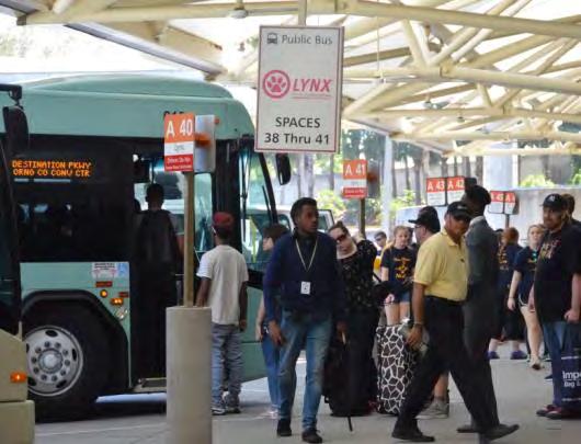
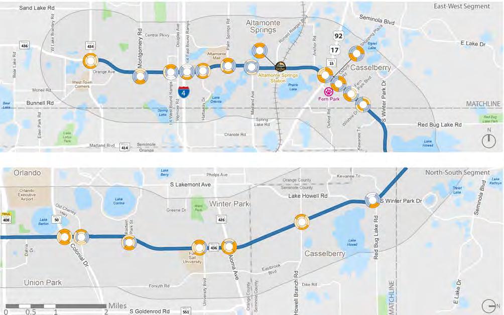
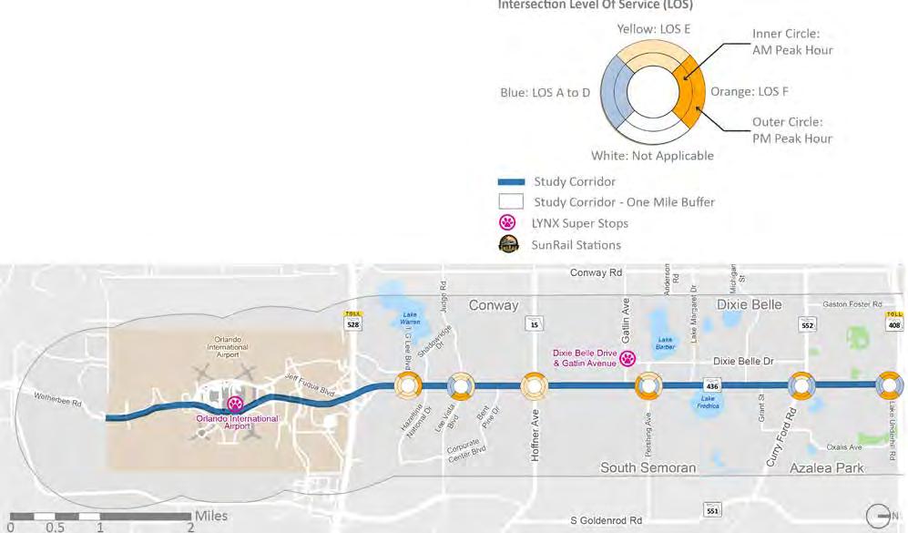
2 I-4 Study Area 23 Miles along SR 436 Regional and gateway corridor Connects 7 jurisdictions 11 LYNX routes along and 8 LYNX routes across the corridor 3 SuperStops SR 434 Red Bug Lake Aloma SR 50 SR 408 Curry Ford Hoffner OIA 2


3 One Street, Many Roles 3


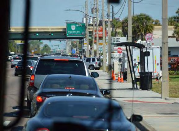
4 One Street, Many Roles 4
5 Schedule What are the issues, opportunities, & objectives? What are our alternatives? Which alternatives best meet our goals & objectives? Which alternatives do we want to move forward? How can we best fund & implement the preferred alternative? 2017 Jan Mar May Jul Sep Nov 2018 Mar May

6 Existing Conditions 6
7 Existing Conditions What are the issues, opportunities, and objectives? 7


8 Travel Patterns Dense employment pockets 86% of trips start or end outside of the corridor Travel patterns emphasize need for system-level thinking 10 Source: LEHD data
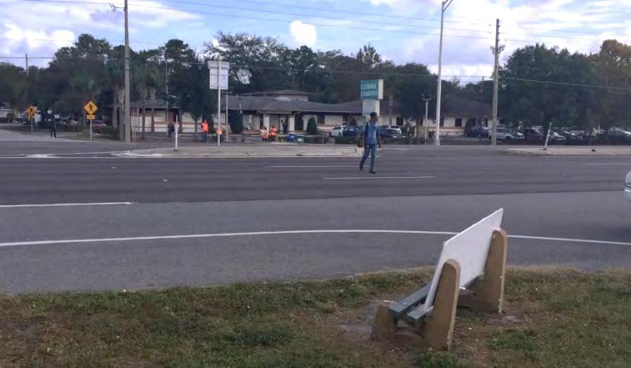
9 Infrastructure Lack of comfortable bicycle and pedestrian facilities along the corridor because of land use and transportation factors 11

10 Infrastructure Ample ROW could be used for multimodal infrastructure Several planning and implementation efforts targeted to address safety 12
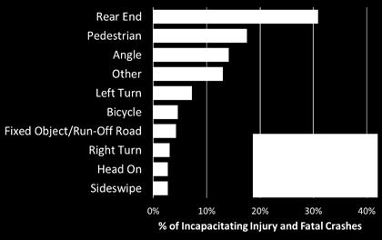
11 Safety Half of all fatal crashes involved pedestrians Rear End Pedestrian Angle Other Left Turn Bicycle Fixed Object/Run-Off Road Right Turn Head On Sideswipe Incapacitating Injury Fatal 0% 10% 20% 30% 40% % of Incapacitating Injury and Fatal Crashes Source: FDOT CARS data ( ) 13

12 Transit Ridership SR 434 I-4 Red Bug Lake Links 436N and 436S account for ~7% of LYNX ridership 15,400 daily boardings and alightings on SR 436 Average weekday ridership on main routes between 2,100 and 3,100 highest of all 30+ minute-headway routes Steady ridership through midday hours Aloma SR 50 SR 408 Curry Ford Hoffner Ridership is dispersed along the long corridor OIA Source: Lynx Automatic Passenger Counter Reports, August 2016 Schedule Period 14
13 Project Goals Enhanced transit experience to support current customers and to increase ridership from a wider range of potential users Safe, comfortable, and accessible walking and bicycling environments Transportation investments that encourage development and redevelopment consistent with community goals Reliable and safe vehicular mobility Transportation improvements that are implementable and financially sustainable Multimodal improvements that support community health 15

14 Alternative Analysis 16
 Identify Screen")
15 Tiered Alternatives Analysis Level 1 Modes Level 2 Alignments Segments Level 3 Prep Operating scenarios Stations Multimodal access (Complete Streets) Identify Screen Select 17

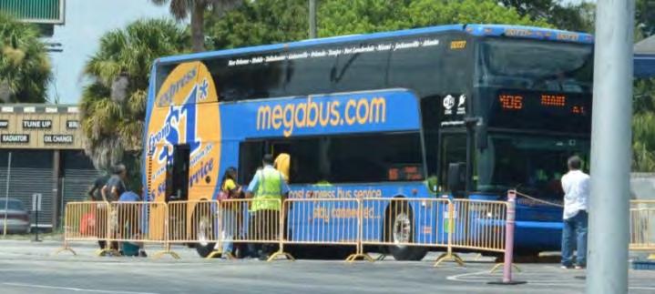
16 Level 1 Alternatives (Modes) BRT - Silver Ex: Cleveland Healthline Fixed Guideway BRT BRT - Bronze Ex: Eugene Emerald Express Corridor-Based BRT Limited-Stop Bus Ex: FastLinks Local Bus 19


17 Limited Stop Bus Albuquerque Rapid Ride Red Line Fort Lauderdale, FL Orlando, FL Limited Stop Bus Up to 120 passengers per vehicle Runs in mixed-traffic Passengers per Up to 120 vehicle Fewer stops; farther apart Average Daily Longer routes, Varies connecting city centers to Ridership smaller suburban centers Typical Route Length 15 to 35 miles May have enhanced stations Stop Spacing Fewer stops, farther apart May have transit signal priority Densities: Residential 10 du/acre Densities: Employees Typically 5 have jobs/acre strong branding and image Capital Costs Regular $1 buses to $2 or million/mile larger buses Operating Cost Peak periods $85 - $130 or all-day per vehicle service hour Defining Capital Costs: - Runs $1-2 in mixed-traffic Million/mile characteristics - Longer routes, connecting city centers to suburban centers - May have enhanced stations - Typically have strong branding and image - Regular buses or larger buses 20


18 Bus Rapid Transit Bus Rapid Transit Average Daily Ridership 4,500 to 1M+ Typical Route Length Stop Spacing Densities: Residential 4 to 25 miles Dependent on land use 5 to 20 du/acre Cleveland Health Line Densities: Employees Capital Costs Operating Cost 30 jobs/acre $4 to $40 million/mile $95 - $150 per vehicle hour Defining characteristics - Enhanced stations - Off-board fare payment - Branding - Transit signal priority - Can run in mixed traffic or on exclusive lanes - Rubber tire vehicles with modern design Orlando Downtown LYMMO 21


19 Elements of Bus Rapid Transit Corridor Based BRT Operates in mixed traffic Frequent bi-directional service on weekdays Defined stations Transit Signal Priority Short headway times Fixed Guideway BRT Operates in exclusive lane on >50% of alignment during peak periods Frequent bi-directional service on weekdays and weekends Defined Stations Transit Signal Priority Short headway times *FTA BRT Categories 22


20 Eugene, OR Emerald Express Branded stations 23


21 Los Angeles, CA Metroliner Real-time info 24


22 Grand Rapids, MI The Rapid Level boarding 25

23 Cleveland, OH Healthline Light rail experience Ticket machines 26
 OIA to SR 50 (green) Aloma Ave to Altamonte Mall (orange) US 17/92 to SR 434 (purple) SR 50 OIA")
24 Level 2 Candidate Alternatives (Alignments/Segments) SR 434 Mall Aloma Ave OIA to SR 434 (red) OIA to Aloma Ave (blue) OIA to SR 50 (green) Aloma Ave to Altamonte Mall (orange) US 17/92 to SR 434 (purple) SR 50 OIA 27

25 Traffic Operations 28

 60")


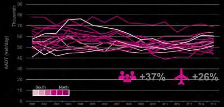
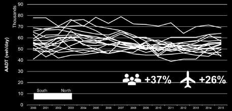
26 Auto Volume over Time Thousands Lines represent individual count stations Between US 17/92 & Red Bug Lake Rd AADT (veh/day) % +26% 10 South North Source: FDOT FTI


27 2015 AADTs Little or no growth in AADTs over the last 15 years I-4 SR 434 Red Bug Lake Aloma SR 50 Concentrated AADT peaks between major cross-streets SR 408 Curry Ford Hoffner OIA 30 Source: FDOT Traffic Online (2015)
.")
28 Average Travel Speeds Slowdowns are limited to certain segments I-4 SR 434 Red Bug Lake Aloma SR 50 No LOS F conditions SR 408 Curry Ford Speeding is common in off-peak Source: HERE/NPMRDS Data (2016). Obtained from FDOT Central Office LOS F= <15 mph LOS E= mph LOS D= mph LOS C= mph LOS B = 31+ mph OIA Hoffner 31
29 Intersection Performance I-4 SR 434 Red Bug Lake Aloma 26 Study Intersections SR 50 SR 408 Curry Ford Hoffner OIA 32
30 Intersection Performance I-4 SR 434 Red Bug Lake Aloma Synchro HCM 2010 SR 50 SR 408 Curry Ford Hoffner OIA 33
31 Intersection ID Crossing Street Crossing Street Direction LOS D or better LOS E LOS F Intersection AM Peak Hour PM Peak Hour SR 436 Crossing Street SR 436 Crossing Street Intersection NB/WB SB/EB EB/NB WB/SB NB/WB SB/EB EB/NB WB/SB 1 TG Lee E/W 66.1(E) 68.2(E) 61.4(E) 72.1(E) 69.8(E) 90.1(F) 66.6(E) 113.8(F) 110.2(F) 76.6(E) 2 Lee Vista E/W 52.6(D) 36.8(D) 45.7(D) 72.3(E) 80.3(F) 63.3(E) 53(D) 56.9(E) 76.4(E) 82.7(F) 3 Hoffner E/W 59.4(E) 55.3(E) 55.6(E) 75.3(E) 71.6(E) 63.2(E) 57.2(E) 55.3(E) 84.7(F) 77(E) 4 Pershing E/W 68.9(E) 39.4(D) 41.9(D) 73.3(E) 172.3(F) 80.8(F) 100.6(F) 60.1(E) 74.2(E) 90.2(F) 5 Curry Ford E/W 62.3(E) 52.6(D) 50.5(D) 64.3(E) 88.5(F) 73.5(E) 53.6(D) 50.5(D) 95.4(F) 116.6(F) 6 Lake Underhill E/W 76(E) 42.5(D) 42.5(D) 161.6(F) 97.9(F) 70.6(E) 45.5(D) 45.9(D) 121.7(F) 118.6(F) 7 SR 50 E/W 82.5(F) 71.9(E) 83.6(F) 82.1(F) 138.2(F) 77.5(E) 73.5(E) 73.5(E) 90.2(F) 100.8(F) 8 Old Cheney Hwy E/W 45.2(D) 34.6(C) 49.2(D) 70.4(E) 68.4(E) 65.6(E) 76.4(E) 52.4(D) 81.9(F) 70.1(E) 9 Baldwin Park St E/W 51.4(D) 30.7(C) 56.1(E) 93.9(F) 99.7(F) 60.6(E) 61.2(E) 49.9(D) 75.3(E) 105.8(F) 10 University Blvd E/W 71(E) 60.9(E) 59.9(E) 156.6(F) 72.5(E) 73.6(E) 62.5(E) 52(D) 127.3(F) 115.8(F) 11 Aloma Ave (SR 426) E/W 72.2(E) 69.7(E) 103.3(F) 27.5(C) 64.7(E) 80.9(F) 92.8(F) 83(F) 56.9(E) 87.8(F) 12 Howell Branch E/W 74.1(E) 76.8(E) 72.1(E) 70.1(E) 76.1(E) 85.5(F) 71.5(E) 72.6(E) 112.2(F) 92.6(F) 13 Red Bug Lake Rd E/W 51.3(D) 33.9(C) 22.8(C) (F) 38.7(D) 28.0(C) 21.2(C) (F) 14 Wilshire Dr N/S 38.6(D) 20.9(C) 20.7(C) 367.3(F) 232.1(F) 28.3(C) 16.9(B) 33.3(C) 74.5(E) 68.7(E) 15 Fern Park Blvd N/S 50.3(D) 55.4(E) 38.5(D) 96.4(F) (D) 30.6(C) 44.7(D) 158(F) - 16 Oxford N/S 37.3(D) 32.2(C) 26(C) 92.6(F) 119.4(F) 41.8(D) 31.4(C) 39.3(D) 90(F) 93.1(F) 17 Shopping Plaza N/S 7.3(A) 1(A) 12.6(B) 86.4(F) 96.6(F) 17.5(B) 2.9(A) 23(C) 87.8(F) 89.4(F) 18 US N/S 80.9(F) 14.7(B) 65.8(E) 538.4(F) 103.2(F) 105.8(F) 26.9(C) 66.7(E) 398.3(F) 126.4(F) 19 CR 427/Ronald Reagan N/S 39(D) 31.9(C) 24.7(C) 89(F) 82.2(F) 32.8(C) 30.8(C) 7(A) 111.6(F) 90.7(F) 20 Maitland Ave N/S 36.9(D) 33.8(C) 37.2(D) 46.5(D) 41.7(D) 54.8(D) 54.1(D) 50.2(D) 65.8(E) 72.3(E) 21 Palm Springs N/S 61(E) 34.1(C) 31.5(C) 67.9(E) 170.3(F) 83.3(F) 27.8(C) 75.8(E) 99.3(F) 278.2(F) 22 Festival Dr / Hattaway N/S 22.5(C) 16.9(B) 18.3(B) 67.6(E) 74.8(E) 49.9(D) 63.4(E) 30.8(C) 92.1(F) 82(F) 23 I-4 Interchange (EB Ramps) N/S 37.5(D) 48.6(D) 20.9(C) 70.7(E) (D) 46(D) 26.3(C) 90.6(F) - 24 I-4 Interchange (WB Ramps) N/S 33.6(C) 16.9(B) 44.2(D) (F) 45(D) 16.9(B) 63.2(E) (F) 25 Montgomery N/S 45.3(D) 27.1(C) 46.8(D) 88.3(F) 67.6(E) 48.6(D) 42.1(D) 47(D) 88.9(F) 65.5(E) 26 SR 434 N/S 66.7(E) 65.3(E) 61.9(E) 70.2(E) 74.4(E) 84.9(F) 62.3(E) 102.9(F) 89.4(F) 81(F) 34
32 35

33 Traffic Impact/Access Study 36


34 Balancing Act Automobil e Regional goals are aligned with high-quality transit High-quality transit requires exclusive/semiexclusive ROW Walking and bicycling comfort and safety increases with slower travel speeds, more crossings, and may require ROW Existing function Existing throughput Existing dev t patterns LYNX Transit Emphasis Corridor High-performing transit route Regional goals 37

35 Potential Project Elements Runningways- curbside vs median Stops or stations Transit signal priority Queue Jumps Bicycle and pedestrian facilities Other amenities 38
36 bike/ped/transit How do project elements impact auto performance? How do project elements impact performance? 39


37 Analysis Tools Macroscopic Mesoscopic Microscopic Complexity and Cost Sources:


38 Analysis Years Historical Trends Parallel Facilities Existing Issues Existing Year Traffic 41
39 Intersection Analysis 42


40 Intersection Analysis I-4 SR 434 Red Bug Lake Aloma Synchro HCM 2010 SR 50 SR 408 Curry Ford Hoffner OIA 43

 Sources: NACTO Transit Street Design")
41 Examples Bus Bulb-outs Existing bus pull-outs Potential bus bulb-outs SR 436, Orlando, FL N 45 th Street, Seattle, WA Sources: Kittelson & Associates, Inc. (2016) Sources: NACTO Transit Street Design Guide (2016) 44

42 Examples Bus Bulb-outs Bus Blockages (#/hr): The number of buses that stop and block traffic at a near-side bus stop... The Bus Blockage assumes an average blockage of 14.4 seconds. -Guidelines for Using Synchro Synchro 45

43 Examples - Transit Queue Jumps Allowing transit vehicles to use right-turn lanes to bypass the queues on the through lanes. Transit vehicles get a head-start over other queued vehicles and merge into the regular travel lanes immediately beyond the signal. 46
")
44 Examples BAT Lanes O Farrell Street, San Francisco, CA Sources: NACTO Transit Street Design Guide (2016) 47


45 Examples BAT Lanes Seattle, WA 48


46 Examples BAT Lanes Blanding Bv, Jacksonville, FL Sources: Google Earth 49
")
47 Examples BAT Lanes with RT Pocket Baseline BAT Lanes With BAT Lanes SR 436 & Lee Vista Blvd Synchro Sources: NACTO Transit Street Design Guide (2016) 50


48 Examples BAT Lanes w/o RT Pocket Baseline BAT Lanes With BAT Lanes SR 436 & Old Cheney Hwy Synchro Sources: NACTO Transit Street Design Guide (2016) 51

49 Examples Exclusive Median Runningways Euclid Avenue, Cleveland, OH Sources: NACTO Transit Street Design Guide (2016) 52

50 Examples Exclusive Median Runningways Baseline Excl. Median Runningways With Excl. Median Runningways SR 436 & Lee Vista Blvd Synchro Sources: NACTO Transit Street Design Guide (2016) 53

51 Roadway Segment Analysis 54


52 Roadway Performance Criteria * LOS A LOS B LOS C LOS D LOS E LOS F * City of Casselberry exempts the SR 436 section between the west city limits and Oxford Road from its LOS standard, marking it as constrained. Sources: FDOT Policy No c, Orange County Code, Seminole County Comprehensive Plan s Transportation Element City of Orlando s Comprehensive Plan s Transportation Element City of Altamonte Springs City Plan 2030 s Multimodal Transportation Element City of Casselberry s Traffic Circulation Element part of their Comprehensive Plan 55


53 Roadway Performance Directional Peak Hour Generalized Service Volume Tables Lanes and volume adjustments per 2013 Q/LOS Handbook Sources: FDOT Quality/Level of Service Handbook 56


54 Roadway Performance FDOT data AADTs Standard K Factor D Factors Study data Lane utilization Signal delays Source: 57


55 Recap Macroscopic Synchro Q/LOS Handbook HCM 2010 Spreadsheets Existing Year Traffic 58
56 Next Steps Revise current TIAS report (baseline) to address FDOT comments Next PAWG meeting (#5) on November 16, 2017 Present Level 2 screening results Develop candidate Level 3 alternatives HIA Working Group meeting (#2) on October 18,

57 Share our website and survey! metroquest-survey/ 60 60


58 Thank You! 61
Semoran Blvd. Transit Study. June 1, 2017 Gateway Guardian Public Safety Meeting Residence Inn, Orlando, FL
 Semoran Blvd. Transit Study June 1, 2017 Gateway Guardian Public Safety Meeting Residence Inn, Orlando, FL I-4 Study Area 23 Miles along SR 436 Regional and gateway corridor Connects 7 jurisdictions 11
METRO RTA TRANSIT MASTER PLAN. May 25-26, 2011
 METRO RTA TRANSIT MASTER PLAN May 25-26, 2011 WHAT IS THE TRANSIT MASTER PLAN? A twenty-year plan for METRO RTA What will METRO look like in 2031? 1 TRANSIT TECHNOLOGIES 2 TRANSIT TECHNOLOGIES Transit
Health Impact Assessment Working Group Meeting #3
 Health Impact Assessment Working Group Meeting #3 January 31, 2018 Casselberry City Hall Multi-Purpose Room Introductions and Icebreaker 2 Agenda SR 436 Transit Corridor Study Update Primary Indicator
Health Impact Assessment Working Group Meeting #2
 Health Impact Assessment Working Group Meeting #2 October 18, 2017 LYNX Central Station LYNX Board Room Introductions and Icebreaker 2 Agenda SR 436 Transit Corridor Study Update HIA Pathway Diagram /
Bus Rapid Transit Plans
 Twin Cities Region Bus Rapid Transit Plans ULI Minnesota Workshop Connecting Bus Rapid Transit to the Community December 15, 2009 John Levin Director of Service Development Metro Transit Metropolitan Area
Wilshire Boulevard Bus Rapid Transit Project
 Los Angeles County Metropolitan Transportation Authority Wilshire Boulevard Bus Rapid Transit Project COMMUNITY MEETINGS November 2008 Agenda Introduction Proposed Project Overview Participating Agencies
Scottsdale Road/Rural Road Alternatives Analysis (AA) Study. Arizona ITE/IMSA Spring Conference March 7, 2012
 Study. Arizona ITE/IMSA Spring Conference March 7, 2012") Scottsdale Road/Rural Road Alternatives Analysis (AA) Study Arizona ITE/IMSA Spring Conference March 7, 2012 Study Location and Duration Primary Study Corridor (major focus of effort) Rural Road and Scottsdale
Scottsdale Road/Rural Road Alternatives Analysis (AA) Study Arizona ITE/IMSA Spring Conference March 7, 2012 Study Location and Duration Primary Study Corridor (major focus of effort) Rural Road and Scottsdale
Waterford Lakes Small Area Study
 Waterford Lakes Small Area Study Existing Traffic Conditions PREPARED FOR: ORANGE COUNTY PUBLIC WORKS DEPARTMENT TRAFFIC ENGINEERING DIVISION ORLANDO, FLORIDA PREPARED WITH: INWOOD CONSULTING ENGINEERS
PURPOSE AND NEED SUMMARY 54% Corridor Need 1. Corridor Need 2. Corridor Need 3. Corridor Need 4. Corridor Need 5
 SUMMARY PURPOSE AND NEED Chapel Hill Transit ridership has increased Buses operate every 4 minutes and have standing room only Exceeding seated capacity by 12% Corridor Need 1 by more than 20 percent between
Model Applications for Oakland Park Boulevard Transit Corridor Study
 Model Applications for Oakland Park Boulevard Transit Corridor Study Southeast Florida FSUTMS Users Group June 13, 2014 Vikas Jain, AICP, GISP FDOT District Four Auditorium 3400 West Commercial Boulevard,
WHAT IS BRT? Jack M. Gonsalves, PE, Parsons Brinckerhoff, Inc. February 22, 2012
 WHAT IS BRT? Jack M. Gonsalves, PE, Parsons Brinckerhoff, Inc. February 22, 2012 What is Bus Rapid Transit (BRT)? A flexible, high performance rapid transit mode that combines a variety of physical, operating,
Community Task Force July 25, 2017
 Community Task Force July 25, 2017 Welcome and Introductions Project Partners Regional Transportation District (RTD) Colorado Department of Transportation (CDOT) Denver Regional Council of Governments
Purpose and Need. Chapter Introduction. 2.2 Project Purpose and Need Project Purpose Project Need
 Chapter 2 Purpose and Need 2.1 Introduction The El Camino Real Bus Rapid Transit (BRT) Project (Project) would make transit and other transportation improvements along a 17.6-mile segment of the El Camino
Planning Study SR 976. Project Advisory Team Meeting May 24, 2017
 ` SR 976 BIRD ROAD/SW 40TH STREET FROM SR 821/HEFT TO SR 5/US-1 Miami-Dade County, Florida FPID No.: 434845-4-22-01 Planning Study Project Advisory Team Meeting May 24, 2017 1 Agenda Introductions Project
Downtown BRT Corridor Alternatives Review: 1 st, 2 nd, 3 rd and 4 th Avenue. Bus Rapid and Conventional Transit Planning and Design Services
 Downtown BRT Corridor Alternatives Review: 1 st, 2 nd, 3 rd and 4 th Avenue Bus Rapid and Conventional Transit Planning and Design Services City of Saskatoon February 2018 Project Team HDR Corporation
Roadways. Roadways III.
 Introduction 97 Roadway Design Principles 98 Safe Speeds 99 Optimizing of Street Space 00 Minimum Lane Widths in the City of Boston 02 Design Features that Reduce Operating Speeds 05 Travel Lanes Transit
Complete Streets in Constrained Corridors: Chicago s Central Loop BRT
 Complete Streets in Constrained Corridors: Chicago s Central Loop BRT NACTO Designing Cities Conference October 24, 2012 Luann Hamilton, Deputy Commissioner What is BRT? Bus-based system that improves
Multimodal Approach to Planning & Implementation of Transit Signal Priority within Montgomery County Maryland
 Multimodal Approach to Planning & Implementation of Transit Signal Priority within Montgomery County Maryland A Path to Successful Implementation James Allday Bunch - Sabra, Wang & Associates, Inc. ITS
Arterial Transitway Corridors Study. Ave
 Arterial Transitway Corridors Study Ave January 2012 Arterial Transitway Corridors Study Overview Corridor Features and Demographics 11 study corridors, 95 route miles 86,000 daily rides and half of existing
Bus Rapid Transit on Silicon Valley s El Camino Real: Working Together to Create a Grand Boulevard Steven Fisher
 Bus Rapid Transit on Silicon Valley s El Camino Real: Working Together to Create a Grand Boulevard Steven Fisher Senior Transportation Planner Santa Clara Valley Transportation Authority San Jose, CA How
MOBILITY WORKSHOP. Joint City Council and Transportation Commission May 5, 2014
 MOBILITY WORKSHOP Joint City Council and Transportation Commission May 5, 2014 Review of General Plan M-1 Develop world-class transit system M-3 Maintain/enhance pedestrian-oriented City M-4 Create comprehensive
Presentation of Staff Draft March 18, 2013 COUNTYWIDE TRANSIT CORRIDORS FUNCTIONAL MASTER PLAN
 Presentation of Staff Draft March 18, 2013 COUNTYWIDE TRANSIT CORRIDORS FUNCTIONAL MASTER PLAN Public Outreach Fall 2011: Two community meetings/open houses Fall 2012: Three community meetings/open houses
Aurora Corridor to E Line
 Aurora Corridor to E Line Jack Whisner Transit Planner, Service Development King County Metro Transit Seattle, Washington jack.whisner@kingcounty.gov 206-477-5847 King County Metro Transit Part of general
Scope of the Transit Priority Project
 Transit Planning Committee #1 March 19, 2015 Scope of the Transit Priority Project Review of the 2010 plan Analysis of Transit Priority Measures Preliminary plans for rapid transit Recommendations for
Eliminate on-street parking where it will allow for a dedicated bus only lane %
 Traffic Dashboard Priorities Survey Responses Introduction 1) Are you familiar with bus rapid transit (BRT)? a. No, BRT is new to me. 597 23.5% b. I ve heard of BRT, but I don t know much about it. 1,136
The current document is revised based on the comments received on:
 General Overview 1 Introduction Over the last several years, the Waterford Lakes area has experienced increased congestion due to a substantial increase in residential and commercial development. The current
Chapter 3 BUS IMPROVEMENT CONCEPTS
 Chapter 3 BUS IMPROVEMENT CONCEPTS The purpose of this chapter is to describe potential bus improvement strategies and potential impacts or implications associated with BRT implementation within the existing
Waterford Lakes Small Area Study
 Over the last several years, the Waterford Lakes area has experienced increased congestion due to a substantial increase in residential and commercial development. The current Existing and Future Conditions
Complete Street Analysis of a Road Diet: Orange Grove Boulevard, Pasadena, CA
 Complete Street Analysis of a Road Diet: Orange Grove Boulevard, Pasadena, CA Aaron Elias, Bill Cisco Abstract As part of evaluating the feasibility of a road diet on Orange Grove Boulevard in Pasadena,
Previous Transit Studies MTTF MEETING #
 Previous Transit Studies MTTF MEETING #4 2013-03-22 Agenda Project timeline Final transit recommendation (2011) Transit planning and development (2002 2011) Moving forward (2011 2013) 2 Project Timeline
Topics To Be Covered. Summarize Tier 2 Council Direction Discuss Mill and Ash Alternatives Next Steps
 Topics To Be Covered Summarize Tier 2 Council Direction Discuss Mill and Ash Alternatives Next Steps Tier 2 Council Direction Dismiss Bus Rapid Transit along the Union Pacific Railroad Dismiss Bus Rapid
Main-McVay Transit Study: Phase 2 Options Definition and High Level Constraints Evaluation
 Main-McVay Transit Study: Phase 2 Options Definition and High Level Constraints Evaluation APRIL 2016 A collaborative study between: For Additional Information or to Comment If you would like additional
NY 5 BRT Conceptual Design Study: Study Advisory Committee Meeting 1. with Creighton Manning Engineering, LLP Logitrans Herb Levinson
 NY 5 BRT Conceptual Design Study: Study Advisory Committee Meeting 1 with Creighton Manning Engineering, LLP Logitrans Herb Levinson September 22, 2003 Overview Introduction to the consultant team Goals
Metropolitan Council Transportation Committee
 Nicollet-Central Transit Alternatives Metropolitan Council Transportation Committee August 2013 Project Purpose (approved by Policy Advisory Committee 10/25/2012) The purpose is to improve transit connectivity,
1 PROJECT DESCRIPTION PROBLEM STATEMENT PROJECT PURPOSE AND NEED Study Purpose Study Need... 4
 January 2014 Table of Contents 1 PROJECT DESCRIPTION... 1 2 PROBLEM STATEMENT... 2 3 PROJECT PURPOSE AND NEED... 3 3.1 Study Purpose... 3 3.2 Study Need... 4 4 GOALS AND OBJECTIVES... 9 4.1 Short-term
EL CAMINO REAL BUS RAPID TRANSIT (BRT) PROJECT
 PROJECT") Agenda Item #4.2 EL CAMINO REAL BUS RAPID TRANSIT (BRT) PROJECT VTA BOARD WORKSHOP MAY 1, 2015 ABOUT THIS PRESENTATION CONTEXT Existing conditions and planning for growth WHAT IS THE PROJECT? Project alternatives
Agenda Item #4.2 EL CAMINO REAL BUS RAPID TRANSIT (BRT) PROJECT VTA BOARD WORKSHOP MAY 1, 2015 ABOUT THIS PRESENTATION CONTEXT Existing conditions and planning for growth WHAT IS THE PROJECT? Project alternatives
Moving Towards Complete Streets MMLOS Applications
 Moving Towards Complete Streets MMLOS Applications Transportation Education Series May 18 th, 2012 It s not just for cars! Presentation Overview The Complete Streets Movement What is Multi-Modal Level
State Road 54/56 Tampa Bay s Northern Loop. The Managed Lane Solution Linking I-75 to the Suncoast Parkway
 State Road 54/56 Tampa Bay s Northern Loop The Managed Lane Solution Linking I-75 to the Suncoast Parkway SUNCOAST PARKWAY Both I 75 and the Suncoast Parkway are planning, or in the process of constructing,
Swift Bus Rapid Transit. June DeVoll, Community Transit & Tom Hingson, Everett Transit
 Swift Bus Rapid Transit June DeVoll, Community Transit & Tom Hingson, Everett Transit October 22, 2013 Swift Washington State s First BRT is almost 4 years old Everett Transit Everett Transit College Station
Bus Rapid Transit ALTERNATIVES ANALYSIS. Open House
 Bus Rapid Transit ALTERNATIVES ANALYSIS Open House June 23, 2015 Open House Meeting Agenda Agenda Introductions What is BRT? Project Goals Study Tasks Next steps Discussion PVTA Bus Rapid Transit Study
Southwest Bus Rapid Transit (SW BRT) Functional Planning Study - Executive Summary January 19 LPT ATTACHMENT 2.
 Functional Planning Study - Executive Summary January 19 LPT ATTACHMENT 2.") Southwest Bus Rapid Transit (SW BRT) Functional Planning Study - Executive Summary 2011 January 19 1 of 19 Introduction This executive summary presents the results of the Southwest Bus Rapid Transit (SW
Southwest Bus Rapid Transit (SW BRT) Functional Planning Study - Executive Summary 2011 January 19 1 of 19 Introduction This executive summary presents the results of the Southwest Bus Rapid Transit (SW
A Selection Approach for BRT Parking Lots Nicolls Road Corridor Parking Study
 A Selection Approach for BRT Parking Lots Nicolls Road Corridor Parking Study Chirantan Kansara, P.E. Engineering Construction Design Planning 2018 ITE Northeastern District Annual Meeting Lake George,
TRAFFIC IMPACT ANALYSIS
 TRAFFIC IMPACT ANALYSIS FOR THE CHAMPAIGN UNIT#4 SCHOOL DISTRICT PROPOSED HIGH SCHOOL (SPALDING PARK SITE) IN THE CITY OF CHAMPAIGN Final Report Champaign Urbana Urbanized Area Transportation Study 6/24/2014
Arterial Transitway Corridors Study
 Arterial Transitway Corridors Study February 2012 Arterial Transitway Corridors Study Overview Corridor Features and Demographics 11 study corridors, 95 route miles Routes: 86,000 daily rides and half
PAWG Meeting 1 & Field Tour DRAFT
 PAWG Meeting 1 & Field Tour Wednesday, March 29, 2017 8 AM to 11:30 AM FDOT Urban Office Lake George Conference Room Meeting Notes In Attendance: Doug Robinson, LYNX Myles O Keefe, LYNX Lorna Hall, LYNX
Operational Comparison of Transit Signal Priority Strategies
 Operational Comparison of Transit Signal Priority Strategies Revision Submitted on: November, 0 Author: Adriana Rodriguez, E.I Assistant Engineer Parsons Brinckerhoff 0 South Orange Avenue, Suite 00 Orlando,
Greater Cleveland Regional Transit Authority
 Greater Cleveland Regional Transit Authority Transit Priority Corridor Initiatives West 25 th Street /East 105 th /East 93 rd Streets June 20, 2017 Presented to: Planning & Development Committee Greater
Philadelphia Bus Network Choices Report
 Philadelphia Bus Network Choices Report JUNE 2018 SEPTA Table of Contents Executive Summary...7 What if transit gave us more freedom?... 8 What is this report?... 8 The main conclusions... 9 What is happening
Arterial Transitway Corridors Study. Sept. 26, 2011
 Arterial Transitway Corridors Study Sept. 26, 2011 Purpose of Study Study 11 urban corridors in Minneapolis, St. Paul and surrounding communities Develop service and facilities plan to improve Transit
ALTERNATIVES ANALYSIS EXECUTIVE SUMMARY
 West Valley Connector Corridor ALTERNATIVES ANALYSIS EXECUTIVE SUMMARY FINAL September 2014 Ontario International Airport Ontario Mills Rancho Cucamonga Metrolink Station Kaiser Permanente PARSONS EXECUTIVE
Road Diets FDOT Process
 Florida Department of TRANSPORTATION Road Diets FDOT Process Humberto Castillero, PE, PTOE Roadway Design Office Purpose of Guide Develop a statewide lane elimination review process Balance state & local
Preliminary Transportation Analysis
 Preliminary Transportation Analysis Goals of a Robust, Multimodal Transportation Network Safe Accessible/Connected Efficient Comfortable Context-Sensitive Motor Vehicle: Continue to analyze the data to
Highway Transitway Corridor Study
 Highway Transitway Corridor Study CTS Research Conference May 21, 2014 1 2030 Transportation Policy Plan Transitway modes on highways: Highway bus rapid transit (BRT), plan identified 6 total Highway BRT
Evan Johnson, Tindale Oliver & Associates. Alan Danaher, P.E., PTOE, AICP, PTP
 To: Copies: From: Evan Johnson, Tindale Oliver & Associates Matt Muller, RTS Jesus Gomez, RTS Alan Danaher, P.E., PTOE, AICP, PTP Date: January 14, 2014 Subject: Ridership Projections Gainesville Streetcar
Technical Working Group November 15, 2017
 Technical Working Group November 15, 2017 Welcome and Introductions Project Partners Regional Transportation District (RTD) Colorado Department of Transportation (CDOT) Denver Regional Council of Governments
David Jickling, Public Transportation Director Regional Transportation Commission, Washoe County
 David Jickling, Public Transportation Director Regional Transportation Commission, Washoe County Virginia Street Resort corridor connecting University of Nevada, Reno Downtown Truckee River Strip Casinos
Telegraph Avenue Complete Streets DRAFT Recommendations. Oakland Public Works Department September 11 and 13, 2014 Open Houses
 Telegraph Avenue Complete Streets DRAFT Recommendations Oakland Public Works Department September 11 and 13, 2014 Open Houses Presentation Overview What are complete streets? What problem are we trying
Seattle Transit Master Plan
 Seattle Transit Master Plan Seattle City Council Transportation Committee Briefing July 26, 2011 Seattle Department of Transportation In Association with: URS Corporation SVR DKS Associates The Underhill
In station areas, new pedestrian links can increase network connectivity and provide direct access to stations.
 The Last Mile Planning for Pedestrians Planning around stations will put pedestrians first. Making walking to stations safe and easy is important; walking will be a part of every rapid transit Accessible
Community Task Force October 5, 2017
 Community Task Force October 5, 2017 Welcome and Introductions Project Partners Regional Transportation District (RTD) Colorado Department of Transportation (CDOT) Denver Regional Council of Governments
Providence Downtown Transit Connector STAKEHOLDER MEETING #2. Stakeholder Meeting #1 October 24, 2016
 Providence Downtown Transit Connector STAKEHOLDER MEETING #2 Stakeholder Meeting #1 October 24, 2016 February 2017 1 AGENDA 1 DTC Goals and Expectations 2 Street Design Concepts 3 Potential Benefits and
BRT for Berkeley A Proposal for Consideration
 BRT for Berkeley A Proposal for Consideration CITY OF BERKELEY STAFF PROPOSAL FOR A LOCALLY PREFERRED ALTERNATIVE OF THE EAST BAY BUS RAPID TRANSIT PROJECT SEPTEMBER 8, 2009 Table of Contents Executive
Town of Bethlehem. Planning Assessment. Bethlehem Town Board
 Town of Bethlehem US 9W Corridor Transportation Planning Assessment Presented e to: Bethlehem Town Board June 2009 Overview Study Background Route 9W Corridor Conditions and Improvements Selkirk Bypass
95 th Street Corridor Transportation Plan. Steering Committee Meeting #2
 95 th Street Corridor Transportation Plan Steering Committee Meeting #2 February 18, 2015 PURPOSE OF THE MEETING Update Steering Committee Present Community/Stakeholder Survey Results Present Transportation
2. TRANSPORTATION ELEMENT.
 2. TRANSPORTATION ELEMENT. The purpose of this element is to assist in establishing an adequate transportation system within the City and to plan for future motorized and non-motorized traffic circulation
1. Operate along freeways, either in regular traffic lanes, in high-occupancy vehicle (HOV) lanes, or along the shoulders.
 lanes, or along the shoulders.") Most decisions about whether or not to use transit involve time and cost, and most transit services are slower than travel by private vehicle. However, when transit is faster or nearly as fast as travel
Most decisions about whether or not to use transit involve time and cost, and most transit services are slower than travel by private vehicle. However, when transit is faster or nearly as fast as travel
Van Ness Avenue BRT Overview and Scoping Process. Geary BRT CAC January 8, 2009
 Van Ness Avenue BRT Overview and Scoping Process Geary BRT CAC January 8, 2009 VAN NESS AVENUE S ROLE Identified in Prop K for BRT treatment Muni 47 and 49; 19 operates on Polk 20,000 daily riders on Van
Route 7 Corridor Study
 Route 7 Corridor Study Executive Summary Study Area The following report analyzes a segment of the Virginia State Route 7 corridor. The corridor study area, spanning over 5 miles in length, is a multi
ADVANCED TRANSIT OPERATIONS AND MODELING
 SOUTHERN DISTRICT OF INSTITUTE OF TRANSPORTATION ENGINEERS (SDITE) 2017 ADVANCED TRANSIT OPERATIONS AND MODELING SURESH KARRE, PE, PTOE ROBERT DUBNICKA, PE, TE, PTOE AGENDA Background Transit operations
EXECUTIVE SUMMARY... vii 1 STUDY OVERVIEW Study Scope Study Area Study Objectives
 Contents EXECUTIVE SUMMARY... vii 1 STUDY OVERVIEW... 1-1 1.1 Study Scope... 1-1 1.2 Study Area... 1-1 1.3 Study Objectives... 1-3 2 EXISTING CONDITIONS... 2-1 2.1 Existing Freeway Conditions... 2-4 2.1.1
Performance Criteria for 2035 Long Range Transportation Plan
 Minimizing Impacts on Natural, Historic, Cultural or Archeological Resources 2035 LRTP Weighting Factor: 7% Objective 1.1: Use appropriate planning and design criteria to protect and enhance the built
CITY OF COCOA BEACH 2025 COMPREHENSIVE PLAN. Section VIII Mobility Element Goals, Objectives, and Policies
 CITY OF COCOA BEACH 2025 COMPREHENSIVE PLAN Section VIII Mobility Element Goals, Objectives, and Policies Adopted August 6, 2015 by Ordinance No. 1591 VIII MOBILITY ELEMENT Table of Contents Page Number
2. Corridor Analysis. Transit Oriented Development. KAT Transit Development Plan. Corridor Analysis CORRADINO. Figure 2-1 Typical Components of TOD
 2. The purpose of this task is to identify transportation corridors in the Knoxville Area that are most suitable for the implementation of possible fixed-guideway, high capacity (rail or bus rapid transit)
Regional Transportation Needs Within Southeastern Wisconsin
 Regional Transportation Needs Within Southeastern Wisconsin #118274 May 24, 2006 1 Introduction The Southeastern Wisconsin Regional Planning Commission (SEWRPC) is the official areawide planning agency
Multimodal Through Corridors and Placemaking Corridors
 68 Multimodal Through Corridors and Placemaking Corridors Corridors have different functions in a region. Some corridors are used to get smoothly and rapidly through a region or to get quickly to major
Bus Rapid Transit Symposium. THOMAS CENTER SPANISH COURT October 14, 2008
 WELCOME Bus Rapid Transit Symposium THOMAS CENTER SPANISH COURT October 14, 2008 Welcome! Jesus Gomez, RTS Director Doug Robinson, RTS Chief Planner Agenda Welcome and Introductions BRT in the United States
Transit Ridership - Why the Decline and How to Increase. Hosted by the. Virginia Transit Association
 Transit Ridership - Why the Decline and How to Increase Hosted by the Virginia Transit Association Virginia Transit Association 1108 East Main Street, Suite 1108 Richmond, VA 23219 804.643.1166 www.vatransit.com
Final Study Recommendations AMES TRANSIT FEASIBILITY STUDY. For Public Review and Comment. October Ames Transit Feasibility Study
 AMES TRANSIT FEASIBILITY STUDY Final Study Recommendations For Public Review and Comment October 2007 Meeting Agenda Existing Service Future Service Transit Feasibility Study Study Purpose/Goals Methodology
List of Exhibits...ii
 One Brickell Traffic Study TABLE OF CONTENTS List of Exhibits...ii EXECUTIVE SUMMARY...1 1. INTRODUCTION...2 1.1 Study Area...2 1.2 Study Objective...5 2. EXISTING TRAFFIC CONDITIONS...6 2.1 Data Collection...6
Detailed Evaluation of Alternatives Report FINAL April 20, North-South Corridor Study
 Detailed Evaluation of Alternatives Report FINAL April 20, 2016 North-South Corridor Study i Table of Contents 1. Introduction... 4 1.1 Overview of Evaluation Process... 4 1.1 Results of the Tier 1 Analysis...
Better Market Street. Engineering, Maintenance & Safety Committee (EMSC) February 28, 2018
 February 28, 2018") Better Market Street Engineering, Maintenance & Safety Committee (EMSC) February 28, 2018 1 Market Street Market Street - San Francisco by rulenumberone2 2 Market Street is the... City s busiest pedestrian
Better Market Street Engineering, Maintenance & Safety Committee (EMSC) February 28, 2018 1 Market Street Market Street - San Francisco by rulenumberone2 2 Market Street is the... City s busiest pedestrian
Project Advisory Group (PAG) Meeting #2 January 31, SR 693 (Pasadena Avenue) Corridor Study from Shore Drive South to 66 th Street
 Meeting #2 January 31, SR 693 (Pasadena Avenue) Corridor Study from Shore Drive South to 66 th Street") Project Advisory Group (PAG) Meeting #2 January 31, 2018 Welcome & Introductions AGENDA 1. Where are we at? 2. Project Survey / Virtual Comment Tool / PAG Meeting #1 / Visioning Workshop Corridor Map Exercise
Project Advisory Group (PAG) Meeting #2 January 31, 2018 Welcome & Introductions AGENDA 1. Where are we at? 2. Project Survey / Virtual Comment Tool / PAG Meeting #1 / Visioning Workshop Corridor Map Exercise
Figure 1: Vicinity Map of the Study Area
 ARIZONA TEXAS NEW MEXICO OKLAHOMA May 5, 2016 Mr. Anthony Beach, P.E. BSP Engineers 4800 Lakewood Drive, Suite 4 Waco, Texas 76710 Re: Intersection and Access Analysis along Business 190 in Copperas Cove
Dr. M.L. King, Jr. Street North Complete Streets Resurfacing Opportunities HOUSING, LAND USE, AND TRANSPORTATION COMMITTEE MARCH 22, 2018
 Dr. M.L. King, Jr. Street North Complete Streets Resurfacing Opportunities HOUSING, LAND USE, AND TRANSPORTATION COMMITTEE MARCH 22, 2018 What s Happening The City plans to mill and resurface Dr. M.L.
Appendix A-K Public Information Centre 2 Materials
 Appendix A-K Public Information Centre 2 Materials Our Rapid Transit Initiative Make an impact on the future of transit Join the discussion on Rapid Transit in London You re invited to a Public Information
Corridor Advisory Group and Task Force Meeting #10. July 27, 2011
 Corridor Advisory Group and Task Force Meeting #10 July 27, 2011 1 Agenda Recap CAG/TF #9 Public Meeting #2 Summary Single Mode Alternatives Evaluation Results Next Steps 2 3 CAG/TF #9 Recap CAG /TF #9
Community Task Force November 15, 2017
 Community Task Force November 15, 2017 Welcome and Introductions Project Partners Regional Transportation District (RTD) Colorado Department of Transportation (CDOT) Denver Regional Council of Governments
Arterial Transitway Corridors Study
 Arterial Transitway Corridors Study April 2012 Prepared by with SRF Consulting Group, Inc. Kimley-Horn and Associates, Inc. Connetics Transportation Group Luken Architecture CR Planning April 2012 Final
City of Gainesville Transportation/Roadway Needs PROJECT SUMMARY
 A1 Roadway Resurfacing $23,846,000 TYPE: Preservation of existing system Roadway resurfacing A2 Signal Replacement $6,000,000 TYPE: Preservation of existing system Replace traffic signals. B1 W 6th St
BUS RAPID TRANSIT. A Canadian Perspective. McCormick Rankin International. John Bonsall P.Eng
 BUS RAPID TRANSIT A Canadian Perspective Why choose BRT? Because it is a practical and cost effective rapid transit solution for the most common types of land use in urban Canada Operating experience shows
Regional Alternatives Analysis. Downtown Corridor Tier 2 Evaluation
 Regional Alternatives Analysis Downtown Corridor Tier 2 Evaluation September 19, 2011 EVALUATION PROCESS REVIEW OF EVALUATION PROCESS Tier 1: Screen Seven Alignment Options into a Short List Tier 2: Evaluate
Kennedy Plaza and Providence Downtown Transit Connector PUBLIC MEETING. Stakeholder Meeting #1 October 24, 2016
 Kennedy Plaza and Providence Downtown Transit Connector PUBLIC MEETING Stakeholder Meeting #1 October 24, 2016 May 2017 1 WHAT IS THE DTC? 1.5 mile corridor between Providence Station and the Hospital
City of Bartow Comprehensive Plan. Transportation Element
 City of Bartow 2030 Comprehensive Plan Amended through January 7, 2013 TRANSPORTATION ELEMENT GOAL: IT SHALL BE A GOAL OF THE CITY OF BARTOW TO PROVIDE A SAFE AND EFFICIENT MULTI-MODAL TRANSPORTATION SYSTEM
I-105 Corridor Sustainability Study (CSS)
") I-105 Corridor Sustainability Study (CSS) Metro Streets and Freeways Subcommittee March 21, 2019 Gary Hamrick Cambridge Systematics, Inc. I-105 CSS Project History & Background Funded by Caltrans Sustainable
I-105 Corridor Sustainability Study (CSS) Metro Streets and Freeways Subcommittee March 21, 2019 Gary Hamrick Cambridge Systematics, Inc. I-105 CSS Project History & Background Funded by Caltrans Sustainable
South King County High-Capacity Transit Corridor Study
 HIGH-CAPACITY TRANSIT CORRIDOR STUDY South King County Corridor South King County High-Capacity Transit Corridor Study Corridor Report August 2014 South King County High Capacity Transit Corridor Report
Integrated Corridor Approach to Urban Transport. O.P. Agarwal World Bank Presentation at CODATU XV Addis Ababa, 25 th October 2012
 Integrated Corridor Approach to Urban Transport O.P. Agarwal World Bank Presentation at CODATU XV Addis Ababa, 25 th October 2012 What is the Integrated Corridor Approach for Urban Transport Public? Why
RETREAT AGENDA ITEM MIDTOWN AREA TRANSPORTATION PLAN UPDATE
 October 17, 2017 RETREAT AGENDA ITEM MIDTOWN AREA TRANSPORTATION PLAN UPDATE STATEMENT OF ISSUE An update on the Midtown Area Transportation Plan will be provided including a discussion of preliminary
Spring Lake Park Mounds View North Oaks. Arden Hills. Shoreview. Roseville. Little Canada. Falcon Heights SNELLING. Lilydale. West Saint Paul 35E
 Coon Rapids Blaine Spring Lake Park Mounds View rth Oaks In 2011, Metro Transit embarked on the Arterial 494 Minnetonka Maple Grove Plymouth Hopkins Brooklyn Park New Hope Golden Valley Louis Park Edina
4 MOBILITY PLAN. Mobility Plan Objectives. Mobility Context. 1. Integrate with Local and Regional Transit Improvements
 Harbor Mixed Use CHAPTER Transit Corridor 4: Mobility Plan 4 MOBILITY PLAN Mobility Plan Objectives The Harbor Corridor Plan seeks to expand and improve the ways that people move along and through the
SFMTA SAN FRANCISCO MUNICIPAL TRANSPORTATION AGENCY
 SFMTA SAN FRANCISCO MUNICIPAL TRANSPORTATION AGENCY VAN NESS BUS RAPID TRANSIT PROJECT UPDATE PRESENTATION TO SFMTA BOARD OF DIRECTORS RELEASE OF DRAFT ENVIRONMENTAL IMPACT STATEMENT / REPORT 10 18 2011