Bus Rapid Transit Symposium. THOMAS CENTER SPANISH COURT October 14, 2008
|
|
|
- Loraine Thornton
- 5 years ago
- Views:
Transcription
1 WELCOME


2 Bus Rapid Transit Symposium THOMAS CENTER SPANISH COURT October 14, 2008
3 Welcome! Jesus Gomez, RTS Director Doug Robinson, RTS Chief Planner

4 Agenda Welcome and Introductions BRT in the United States Presentation of BRT in Eugene, Oregon Presentation of BRT in Kansas City, MO Presentation by the Alachua County MTPO Questions and Answers from the Audience - Panel Discussion

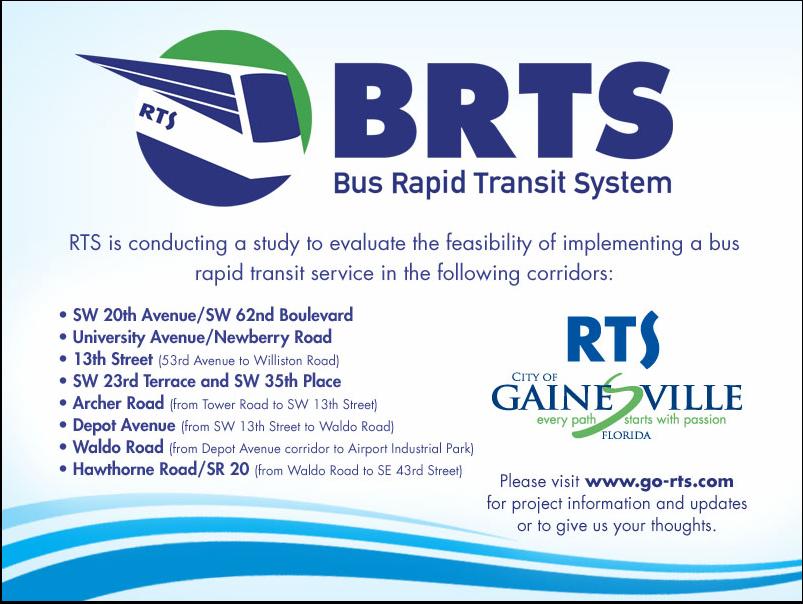
5 GO-RTS.COM

6 Study Corridors
7 BRT Study Corridors SW 20th Avenue/SW 62nd Boulevard University Avenue/Newberry Road 13th Street (53rd Avenue to Williston Road) SW 23rd Terrace and SW 35th Place Archer Road (from Tower Road to SW 13th Street) Depot Avenue (from SW 13th Street to Waldo Road) Waldo Road (from Depot Avenue corridor to Airport Industrial Park) Hawthorne Road/SR 20 (from Waldo Road to SE 43rd Street)

8 Nothing happens unless first a dream. - Carl Sandburg Thanks! GO-RTS.COM
9
10 Agenda Welcome and Introductions BRT in the United States (Dennis Hinebaugh, Director, National Bus Rapid Institute) Presentation of BRT in Eugene, Oregon (Graham Carey, Lane Transit District) Presentation of BRT in Kansas City, MO (Dick Jarrold,, Kansas City Area Transportation Authority) Panel Discussion (Rob Gregg, CUTR) Presentation by the Alachua County Metropolitan Transportation Planning Organization (Marlie( Sanderson) Questions and Answers from the Audience
11

12 Small Starts/Very Small Starts Reporting Checklist

13 Small Starts/Very Small Starts Reporting Checklist (continued)

14 Small Starts Projects AZ, Flagstaff Mountain, Links BRT CA, Livermore, Livermore-Amador Rt.10 BRT CA, LosAngeles,, Gap Closure Project CA, LosAngeles,, Wilshire Boulevard Bus Only Lane CA, Riverside, Perris Valley Line CA, San Bernadino,, E Street Corridor SBX BRT CA, San Diego, Mid-City Rapid CA, San Francisco, VanNess Ave BRT CO, FortCollins,, Mason Corridor BRT MA, Fitchburg, Fitchburg Commuter Rail Improvement MI, GrandRapids,, South Corridor BRT MO, KansasCity, TroostCorridor BRT OR, Portland, Streetcar Loop OR, Springfield, Pioneer Parkway BRT WA, King County, Bellevue Redmond BRT WA, Seatac,, Pacific Highway BRT
15 Small Starts Evaluation Criteria Cost Effectiveness; Transit Supportive Land Use Policies and Future Patterns; and Other Factors, including economic development, as well as if the project is a principle element of a congestion management strategy, the Making the Case document, and any other locally- reported factors
16 Small Starts Eligibility Under $75M Section 5309 Scaled down planning & project development process Any public body with legal, technical, and financial capacity Operation ability must be demonstrated


17 BRT Key Objectives Improve image of transit Operate like rail Stations rather than stops Unique identity/branding Use new technology Signal priority, real-time signs, stop announcements Reduce travel time by 20% Develop in partnership with City and community Increase corridor ridership
18 FTA Funded Guidelines Small / Very Small Starts New 5309 Funding Category Up to $75M (FTA); Overall Project up to $250M Simplified Process for smaller projects including bus rapid transit, streetcar, commuter rail, and other fixed guideway projects. Target: Get into Project Development and on Annual Report on Funding Recommendations
19 Tasks Task 1: Project Management & Coordination Task 2: Develop a Public Involvement Plan (PIP) and conduct public workshops Task 3: Collect Data and coordinate with local transportation organizations Task 4: Identify Potential Corridors for Rapid Transit Consideration Task 5: Develop Criteria Screening Process for Corridor Evaluation Task 6: Conduct Technology Assessment Task 7: Conduct Corridor Selection and Refinement Task 8: Prioritize Alternative Service/Configurations Task 9: Select Final Priority Corridors and Prepare Implementation Plans Task10: Develop BRT Project Schedule and Milestones Task11: Prepare Draft Final Report
20 Criteria Consideration existing and future transit demand existing transit services and infrastructure future transit market potential existing and future corridor residential and employment densities existing and future roadway and intersection geometries existing and future traffic conditions and travel flows compatibility with regional and local plans environmental/row constraints environmental justice
21 Evaluation Criteria Example Objectives Initial Screening Matrix Criteria A. Ridership 1. Current ridership B. Capital Cost Effectiveness C. Operating Cost Efficiency D. Development Potential E. Accessibility 1. Right-of of-way availability 2. Potential for coordinated improvements 1. Intersection delay potential 2. Level of congestion 1. Density Threshold Assessment 1. Neighborhood accessibility & transit dependency 2. Transit connectivity 3. Regional connectivity Measure Average weekday ridership per mile Pinellas County GIS parcel data Percent of corridor with planned roadway improvements Number of signalized intersections per mile Average roadway Level of Service in corridor DTA index based on residential and employment densities TOI index based on Census demographic characteristics Number of transfer opportunities with existing non-parallel PSTA routes per mile (with focus on BRT network connectivity.) Number of transfer opportunities with inter- county services or connection Thresholds Weight Score 3 High 1 High 2 High 2 High 1 D or better 3 High 1 High 1 High Med Medium Medium Mediu m E Medium Medium Mediu m Low Low Low Low F Low Low Low
22
Topics To Be Covered. Summarize Tier 2 Council Direction Discuss Mill and Ash Alternatives Next Steps
 Topics To Be Covered Summarize Tier 2 Council Direction Discuss Mill and Ash Alternatives Next Steps Tier 2 Council Direction Dismiss Bus Rapid Transit along the Union Pacific Railroad Dismiss Bus Rapid
Arterial Transitway Corridors Study. Ave
 Arterial Transitway Corridors Study Ave January 2012 Arterial Transitway Corridors Study Overview Corridor Features and Demographics 11 study corridors, 95 route miles 86,000 daily rides and half of existing
South King County High-Capacity Transit Corridor Study
 HIGH-CAPACITY TRANSIT CORRIDOR STUDY South King County Corridor South King County High-Capacity Transit Corridor Study Corridor Report August 2014 South King County High Capacity Transit Corridor Report
SMART 1 Public Meeting #1. February 24, 2016
 SMART 1 Public Meeting #1 February 24, 2016 Agenda Who is the SMTC? SMART 1 project overview Syracuse Metropolitan Transportation Council An Introduction: Who we are & what we do What is an MPO? A Metropolitan
Bus Rapid Transit Plans
 Twin Cities Region Bus Rapid Transit Plans ULI Minnesota Workshop Connecting Bus Rapid Transit to the Community December 15, 2009 John Levin Director of Service Development Metro Transit Metropolitan Area
GAINESVILLE REGIONAL TRANSIT SYSTEM RAPID TRANSIT FEASIBILITY STUDY DRAFT REPORT
 GAINESVILLE REGIONAL TRANSIT SYSTEM RAPID TRANSIT FEASIBILITY STUDY DRAFT REPORT Prepared For: GAINESVILLE REGIONAL TRANSIT SYSTEM P.O. Box 490, Station 4 Gainesville, Florida 60 Ph () 4-609, fax () 4-607
Community Task Force July 25, 2017
 Community Task Force July 25, 2017 Welcome and Introductions Project Partners Regional Transportation District (RTD) Colorado Department of Transportation (CDOT) Denver Regional Council of Governments
Highway Transitway Corridor Study
 Highway Transitway Corridor Study CTS Research Conference May 21, 2014 1 2030 Transportation Policy Plan Transitway modes on highways: Highway bus rapid transit (BRT), plan identified 6 total Highway BRT
Community Engagement Process
 Community Engagement Process PHASE ONE PURPOSE + NEED STATEMENT IDEAS DESTINATIONS TRAVEL PATTERNS PHASE TWO MODE SELECTION INPUT PHASE THREE LOCALLY PREFERRED ALTERNATIVE SELECTION OF PREFERRED ALTERNATIVE
Purpose and Need. Chapter Introduction. 2.2 Project Purpose and Need Project Purpose Project Need
 Chapter 2 Purpose and Need 2.1 Introduction The El Camino Real Bus Rapid Transit (BRT) Project (Project) would make transit and other transportation improvements along a 17.6-mile segment of the El Camino
Mobility Plan Status Report 2012 Average Annual Daily Traffic
 Mobility Plan Status Report 2012 Average Annual Daily Traffic Gainesville Metropolitan Area Congestion Management Process January 22, 2014 Metropolitan Transportation Planning Organization for the Gainesville
Transit Ridership - Why the Decline and How to Increase. Hosted by the. Virginia Transit Association
 Transit Ridership - Why the Decline and How to Increase Hosted by the Virginia Transit Association Virginia Transit Association 1108 East Main Street, Suite 1108 Richmond, VA 23219 804.643.1166 www.vatransit.com
Evan Johnson, Tindale Oliver & Associates. Alan Danaher, P.E., PTOE, AICP, PTP
 To: Copies: From: Evan Johnson, Tindale Oliver & Associates Matt Muller, RTS Jesus Gomez, RTS Alan Danaher, P.E., PTOE, AICP, PTP Date: January 14, 2014 Subject: Ridership Projections Gainesville Streetcar
City of Gainesville Transportation/Roadway Needs PROJECT SUMMARY
 A1 Roadway Resurfacing $23,846,000 TYPE: Preservation of existing system Roadway resurfacing A2 Signal Replacement $6,000,000 TYPE: Preservation of existing system Replace traffic signals. B1 W 6th St
Performance Criteria for 2035 Long Range Transportation Plan
 Minimizing Impacts on Natural, Historic, Cultural or Archeological Resources 2035 LRTP Weighting Factor: 7% Objective 1.1: Use appropriate planning and design criteria to protect and enhance the built
ALTERNATIVES ANALYSIS EXECUTIVE SUMMARY
 West Valley Connector Corridor ALTERNATIVES ANALYSIS EXECUTIVE SUMMARY FINAL September 2014 Ontario International Airport Ontario Mills Rancho Cucamonga Metrolink Station Kaiser Permanente PARSONS EXECUTIVE
Dumbarton Transportation Corridor Study. San Francisco Bay ITE November 2016
 Dumbarton Transportation Corridor Study San Francisco Bay ITE November 2016 Dumbarton Corridor Source: Wikipedia 2 Dumbarton Corridor 3 Growth Imbalance Jobs-housing imbalance Major employers driving growth
Scottsdale Road/Rural Road Alternatives Analysis (AA) Study. Arizona ITE/IMSA Spring Conference March 7, 2012
 Study. Arizona ITE/IMSA Spring Conference March 7, 2012") Scottsdale Road/Rural Road Alternatives Analysis (AA) Study Arizona ITE/IMSA Spring Conference March 7, 2012 Study Location and Duration Primary Study Corridor (major focus of effort) Rural Road and Scottsdale
Scottsdale Road/Rural Road Alternatives Analysis (AA) Study Arizona ITE/IMSA Spring Conference March 7, 2012 Study Location and Duration Primary Study Corridor (major focus of effort) Rural Road and Scottsdale
Corridor Advisory Group and Task Force Meeting #10. July 27, 2011
 Corridor Advisory Group and Task Force Meeting #10 July 27, 2011 1 Agenda Recap CAG/TF #9 Public Meeting #2 Summary Single Mode Alternatives Evaluation Results Next Steps 2 3 CAG/TF #9 Recap CAG /TF #9
Appendix A-1: Purpose and Need Statement
 Appendix A-1: Purpose and Need Statement PURPOSE AND NEED STATEMENT Western & Ashland Corridors Bus Rapid Transit (BRT) Project Prepared for Chicago Transit Authority 567 West Lake Street Chicago, IL 60661
EL CAMINO REAL BUS RAPID TRANSIT (BRT) PROJECT
 PROJECT") Agenda Item #4.2 EL CAMINO REAL BUS RAPID TRANSIT (BRT) PROJECT VTA BOARD WORKSHOP MAY 1, 2015 ABOUT THIS PRESENTATION CONTEXT Existing conditions and planning for growth WHAT IS THE PROJECT? Project alternatives
Agenda Item #4.2 EL CAMINO REAL BUS RAPID TRANSIT (BRT) PROJECT VTA BOARD WORKSHOP MAY 1, 2015 ABOUT THIS PRESENTATION CONTEXT Existing conditions and planning for growth WHAT IS THE PROJECT? Project alternatives
Metropolitan Council Transportation Committee
 Nicollet-Central Transit Alternatives Metropolitan Council Transportation Committee August 2013 Project Purpose (approved by Policy Advisory Committee 10/25/2012) The purpose is to improve transit connectivity,
Van Ness Avenue BRT Overview and Scoping Process. Geary BRT CAC January 8, 2009
 Van Ness Avenue BRT Overview and Scoping Process Geary BRT CAC January 8, 2009 VAN NESS AVENUE S ROLE Identified in Prop K for BRT treatment Muni 47 and 49; 19 operates on Polk 20,000 daily riders on Van
Bus Rapid Transit ALTERNATIVES ANALYSIS. Open House
 Bus Rapid Transit ALTERNATIVES ANALYSIS Open House June 23, 2015 Open House Meeting Agenda Agenda Introductions What is BRT? Project Goals Study Tasks Next steps Discussion PVTA Bus Rapid Transit Study
Title. Metropolitan Council Transportation Committee December 12, Brad Larson Metro District MnDOT
 Title Metropolitan Council Transportation Committee December 12, 2016 Evaluating the potential for Bus Rapid Transit and MnPASS Express Lanes in the southwest Metro Brad Larson Metro District MnDOT Background
Presentation of Staff Draft March 18, 2013 COUNTYWIDE TRANSIT CORRIDORS FUNCTIONAL MASTER PLAN
 Presentation of Staff Draft March 18, 2013 COUNTYWIDE TRANSIT CORRIDORS FUNCTIONAL MASTER PLAN Public Outreach Fall 2011: Two community meetings/open houses Fall 2012: Three community meetings/open houses
North Coast Corridor:
 North Coast Corridor: Connecting People, Transportation & Environment Legislative Hearing: 11.8.10 1 North Coast Corridor Region s Lifeline A Regional Strategy Mobility, Economy & Environment North Coast
Westside Transportation Access Needs Assessment - Short and Long Term Improvements
 ABSTRACT The Los Angeles County Metropolitan Transportation Authority (MTA) adopted the 2001 Long Range Transportation Plan (LRTP), which sets out the County s transportation investments for the next 20-25
Station Plan: Penn & 43rd Avenue
 Station Plan: Penn & 43rd Avenue This station will serve the northern portion of the Penn Avenue corridor, including the commercial node at 44th Avenue. Ridership and roadway geometry support station siting
Measuring the Distribution and Costs of Congestion. Tim Lomax Texas Transportation Institute
 Measuring the Distribution and Costs of Congestion Tim Lomax Texas Transportation Institute http://mobility.tamu.edu The Congestion Measurement Story Travel time, variations, compare to goals WHAT? WHY?
McGrath Boulevard Project Development Public Meeting #2 May 28 th, 2015 East Somerville Community School
 McGrath Boulevard Project Development Public Meeting #2 May 28 th, 2015 East Somerville Community School Agenda Introductions Project Context Current Construction McGrath Boulevard Project Development
Transit Planning at 3 Scales: the Network, Corridor, and Station Levels
 Transit Planning at 3 Scales: the Network, Corridor, and Station Levels Case studies of challenges, solutions and lessons learned Elizabeth Mros-O Hara, John Katz, Charles Carlson, Alicia McIntire, and
Seattle Transit Master Plan
 Seattle Transit Master Plan Seattle City Council Transportation Committee Briefing July 26, 2011 Seattle Department of Transportation In Association with: URS Corporation SVR DKS Associates The Underhill
Appendix A-2: Screen 1 Alternatives Report
 Appendix A-2: Screen 1 Alternatives Report SCREEN 1 ALTERNATIVES REPORT Western & Ashland Corridors Bus Rapid Transit (BRT) Project Prepared for Chicago Transit Authority 567 West Lake Street Chicago,
Transportation Mobility Element
 Transportation Mobility Element Goals, OVERALL GOAL: ESTABLISH A TRANSPORTATION SYSTEM THAT ENHANCES COMPACT DEVELOPMENT, REDEVELOPMENT, AND QUALITY OF LIFE, THAT IS SENSITIVE TO CULTURAL AND ENVIRONMENTAL
STUDY ADVISORY COMMITTEE. October 8, 2015
 STUDY ADVISORY COMMITTEE October 8, 2015 Study Purpose evaluate the long-term transportation strategies and investments needed to sustain the county s economic health and quality of life in the coming
COASTAL RAIL TRAIL ROSE CREEK BIKEWAY PROJECT COMMUNITY WORKSHOP #2 AUGUST 15, 2013
 COASTAL RAIL TRAIL ROSE CREEK BIKEWAY PROJECT COMMUNITY WORKSHOP #2 AUGUST 15, 2013 CHRIS CARTERETTE, AICP PROJECT MANAGER Chris.Carterette@sandag.org Direct: 619-699.7319 REGIONAL PLANNING BACKGROUND
Cedar Avenue Transitway/ METRO Red Line Implementation Plan Update. Metropolitan Transportation Committee July 27, 2015
 Cedar Avenue Transitway/ METRO Red Line Implementation Plan Update Metropolitan Transportation Committee July 27, 2015 Purpose of Cedar Avenue Transitway Previous IPU August 2011 Review current transit
Memorandum. Fund Allocation Fund Programming Policy/Legislation Plan/Study Capital Project Oversight/Delivery Budget/Finance Contract/Agreement Other:
 Memorandum Date: November 20, 2017 To: Transportation Authority Board From: Eric Cordoba Deputy Director Capital Projects Subject: 12/5/17 Board Meeting: San Francisco Freeway Corridor Management Study
EXECUTIVE SUMMARY... vii 1 STUDY OVERVIEW Study Scope Study Area Study Objectives
 Contents EXECUTIVE SUMMARY... vii 1 STUDY OVERVIEW... 1-1 1.1 Study Scope... 1-1 1.2 Study Area... 1-1 1.3 Study Objectives... 1-3 2 EXISTING CONDITIONS... 2-1 2.1 Existing Freeway Conditions... 2-4 2.1.1
Greater Cleveland Regional Transit Authority
 Greater Cleveland Regional Transit Authority Transit Priority Corridor Initiatives West 25 th Street /East 105 th /East 93 rd Streets June 20, 2017 Presented to: Planning & Development Committee Greater
Arterial Transitway Corridors Study. Sept. 26, 2011
 Arterial Transitway Corridors Study Sept. 26, 2011 Purpose of Study Study 11 urban corridors in Minneapolis, St. Paul and surrounding communities Develop service and facilities plan to improve Transit
I-25 PEL: CO Springs Denver South Connection. Presentation to Castle Rock Town Council
 I-25 PEL: CO Springs Denver South Connection Presentation to Castle Rock Town Council June 20, 2017 An Important Corridor to Colorado Links the state s two major metropolitan areas and communities between
Sixth Line Development - Transit Facilities Plan
 Memorandum Date: November 13, 2012 To: From: c.c. Subject: Rob Freeman (Freeman Planning) Kevin Phillips Sixth Line Development - Transit Facilities Plan 33016631 This memo was prepared to review the transit
Highway 169 Mobility Study Technical Advisory Committee Meeting #9 Meeting Record
 Highway 169 Mobility Study Technical Advisory Committee Meeting #9 Meeting Record Thursday, May 25, 2017 8:30-10:30 a.m. City of Eden Prairie Heritage Rooms I and II Attendees Brad Larsen, MnDOT Angie
San Mateo County Comprehensive Bicycle and Pedestrian Plan
 San Mateo County Comprehensive Bicycle and Pedestrian Plan August 26, 2010 Presented to the San Mateo County BPAC by Lauren Ledbetter, Alta Planning + Design in association with: Fehr & Peers Eisen Letunic
Spring Lake Park Mounds View North Oaks. Arden Hills. Shoreview. Roseville. Little Canada. Falcon Heights SNELLING. Lilydale. West Saint Paul 35E
 Coon Rapids Blaine Spring Lake Park Mounds View rth Oaks In 2011, Metro Transit embarked on the Arterial 494 Minnetonka Maple Grove Plymouth Hopkins Brooklyn Park New Hope Golden Valley Louis Park Edina
PURPOSE AND NEED SUMMARY 54% Corridor Need 1. Corridor Need 2. Corridor Need 3. Corridor Need 4. Corridor Need 5
 SUMMARY PURPOSE AND NEED Chapel Hill Transit ridership has increased Buses operate every 4 minutes and have standing room only Exceeding seated capacity by 12% Corridor Need 1 by more than 20 percent between
Evaluation of Alternatives and Final Screening Results November 20 and 21, 2013
 Midtown Corridor Alternatives ti Analysis Evaluation of Alternatives and Final Screening Results November 20 and 21, 2013 Today s Agenda Alternatives background Process update Key evaluation factors cost
Arterial Transitway Corridors Study
 Arterial Transitway Corridors Study February 2012 Arterial Transitway Corridors Study Overview Corridor Features and Demographics 11 study corridors, 95 route miles Routes: 86,000 daily rides and half
ADOT Statewide Bicycle and Pedestrian Program Summary of Phase IV Activities APPENDIX B PEDESTRIAN DEMAND INDEX
 ADOT Statewide Bicycle and Pedestrian Program Summary of Activities APPENDIX B PEDESTRIAN DEMAND INDEX May 24, 2009 Pedestrian Demand Index for State Highway Facilities Revised: May 29, 2007 Introduction
Preliminary Transportation Analysis
 Preliminary Transportation Analysis Goals of a Robust, Multimodal Transportation Network Safe Accessible/Connected Efficient Comfortable Context-Sensitive Motor Vehicle: Continue to analyze the data to
San Mateo County Comprehensive Bicycle and Pedestrian Plan Open House
 San Mateo County Comprehensive Bicycle and Pedestrian Plan Open House October 28, 2010 Presented to San Mateo County residents and interested parties by Lauren Ledbetter, Alta Planning + Design Matt Haynes,
POLICY ADVISORY COMMITTEE
 September 27, 2018 POLICY ADVISORY COMMITTEE ENVIRONMENTAL ANALYSIS PHASE Agenda 1. Welcome and introductions. 2. Overview of project activities and process. 3. Public engagement update. 4. Community Advisory
Goodlettsville Bicycle and Pedestrian Plan Executive Summary
 Goodlettsville Bicycle and Pedestrian Plan July 2010 In Cooperation with the Nashville Area Metropolitan Planning Executive Organization Summary Introduction Progressive and forward thinking communities
Tulsa Metropolitan Area LONG RANGE TRANSPORTATION PLAN
 Tulsa Metropolitan Area LONG RANGE TRANSPORTATION PLAN Indian Nations Council of Governments August 2005 CONTACTING INCOG In developing the Destination 2030 Long Range Transportation Plan, INCOG s Transportation
Managed Lanes. Steve Schilke, P.E. Major Projects Unit Head District 1. Illinois Traffic Engineering and Safety Conference October 2016
 Managed Lanes Steve Schilke, P.E. Major Projects Unit Head District 1 Illinois Traffic Engineering and Safety Conference October 2016 Agenda Managed Lanes Projects I-55 (Stevenson Expressway) Express Toll
Transportation in Washoe County. Lee Gibson, Executive Director February 15, 2011
 Transportation in Washoe County Lee Gibson, Executive Director February 15, 2011 RTC OF WASHOE COUNTY Metropolitan Planning Organization Meet long term needs Deliver federal funding Program projects in
Hennepin County Bicycle and Pedestrian Planning
 Hennepin County Bicycle and Pedestrian Planning 1 Value of bicycle and sidewalk systems Safety Livability Mobility Health Personal Finances Economic Sustainability Clean Air Recreation Parking and congestion
Arlington County 10-Year Transit Development Plan & Premium Transit Network Briefing. May 2016
 Arlington County 10-Year Transit Development Plan & Premium Transit Network Briefing May 2016 Overview 10-Year Transit Development Plan Premium Transit Network Columbia Pike service concept Premium amenities
SFMTA SAN FRANCISCO MUNICIPAL TRANSPORTATION AGENCY
 SFMTA SAN FRANCISCO MUNICIPAL TRANSPORTATION AGENCY VAN NESS BUS RAPID TRANSIT PROJECT UPDATE PRESENTATION TO SFMTA BOARD OF DIRECTORS RELEASE OF DRAFT ENVIRONMENTAL IMPACT STATEMENT / REPORT 10 18 2011
Main-McVay Transit Study: Phase 2 Options Definition and High Level Constraints Evaluation
 Main-McVay Transit Study: Phase 2 Options Definition and High Level Constraints Evaluation APRIL 2016 A collaborative study between: For Additional Information or to Comment If you would like additional
Appendix C. NORTH METRO STATION AREA TRAFFIC IMPACT STATEMENT 88th Avenue Station
 Appendix C NORTH METRO STATION AREA TRAFFIC IMPACT STATEMENT 88th Avenue Station Prepared for: Regional Transportation Department and URS Corporation as part of the North Metro EIS David Evans and Associates,
Sustainable Transportation Planning in the Portland Region
 Sustainable Transportation Planning in the Portland Region Jennifer Dill, Ph.D. Associate Professor School of Urban Studies & Planning jdill@pdx.edu http://web.pdx.edu/~jdill/ Outline Elements of a sustainable
ACTION TRANSMITTAL No
 Transportation Advisory Board of the Metropolitan Council of the Twin Cities ACTION TRANSMITTAL No. 2016-15 DATE: January 14, 2016 TO: TAC Planning Committee PREPARED BY: Steven Elmer (651) 602-1756 SUBJECT:
SR 693 (Pasadena Avenue) Corridor Study from Shore Drive South to 66 th Street
 Corridor Study from Shore Drive South to 66 th Street") Welcome and Introduction Sign-in and comment sheets Restrooms and exits Meeting agenda and timeline Meeting goals / expectations Provide input to guide study recommendations Actively participate throughout
Welcome and Introduction Sign-in and comment sheets Restrooms and exits Meeting agenda and timeline Meeting goals / expectations Provide input to guide study recommendations Actively participate throughout
Decision on North Waterloo Routing
 Next Steps Decision on North Waterloo Routing Two route variations remain in north Waterloo. The final preferred route will include only one of the two variations. Please consider these two variations
METRO RTA TRANSIT MASTER PLAN. May 25-26, 2011
 METRO RTA TRANSIT MASTER PLAN May 25-26, 2011 WHAT IS THE TRANSIT MASTER PLAN? A twenty-year plan for METRO RTA What will METRO look like in 2031? 1 TRANSIT TECHNOLOGIES 2 TRANSIT TECHNOLOGIES Transit
In station areas, new pedestrian links can increase network connectivity and provide direct access to stations.
 The Last Mile Planning for Pedestrians Planning around stations will put pedestrians first. Making walking to stations safe and easy is important; walking will be a part of every rapid transit Accessible
SANTA MONICA BOULEVARD CORRIDOR
 CIRCULATION ELEMENT WHITE PAPER NO. 3 SANTA MONICA BOULEVARD CORRIDOR INTRODUCTION From the 1930s to the beginning of Los Angeles freeway era, Santa Monica Boulevard, (previously Route 66, the Beverly
lowercase tod Rail~Volution October 22, 2013 Melanie Hare
 lowercase tod Rail~Volution October 22, 2013 Melanie Hare mhare@urbanstrategies.com overview 1 the challenge 2 on the ground 3 strategies the challenge suburban cities planning for re-urbanization and
Everett Transit Action Plan. Community Open House November 16, 2015
 Everett Transit Action Plan Community Open House Everett has a great location, but getting around the city and into surrounding communities is a problem for all ages Many Voices, One Future: The Everett
Governor s Transportation Vision Panel
 Office of Governor Kate Brown Governor s Transportation Vision Panel JLA Public Involvement Project Overview The is a yearlong effort to develop a series of recommendations for the Governor that address
Previous Transit Studies MTTF MEETING #
 Previous Transit Studies MTTF MEETING #4 2013-03-22 Agenda Project timeline Final transit recommendation (2011) Transit planning and development (2002 2011) Moving forward (2011 2013) 2 Project Timeline
BUILDING THE CASE FOR TRAVEL OPTIONS IN WASHING TON COUNTY. Image: Steve Morgan. Image: Steve Morgan
 BUILDING THE CASE FOR TRAVEL OPTIONS IN WASHING TON COUNTY Image: Steve Morgan Image: Steve Morgan Image: TriMet Image: TriMet WHAT ARE TRAVEL OPTIONS PROGRAMS? Travel options programs encourage residents,
Sacramento Grid 2.0. The Downtown Transportation Study
 Sacramento Grid 2.0 The Downtown Transportation Study April 20, 2016 The Grid 4.25 square miles Street grid defined at birth of City Lettered and numbered streets spaced every 400 ft East-west alleys halfway
I-35W Solutions Alliance Project Update July 13, 2017
 Title I-35W Solutions Alliance Project Update July 13, 2017 Evaluating the potential for Bus Rapid Transit and MnPASS Express Lanes in the southwest Metro, Investigating options for improved bus service
Pocatello Regional Transit Master Transit Plan Draft Recommendations
 Pocatello Regional Transit Master Transit Plan Draft Recommendations Presentation Outline 1. 2. 3. 4. What is the Master Transit Plan? An overview of the study Where Are We Today? Key take-aways from existing
VISION Long Range Plan Update Board Workshop. February 10, 2016
 VISION 2040 Long Range Plan Update Board Workshop February 10, 2016 Vision 2040 Key Milestones UNDERSTAND THE NEED IDENTIFY A RANGE OF OPTIONS EVALUATE COMMUNITY OPTIONS DEFINE PROJECTS & PLANS Vision
Moving Cambridge. City of Cambridge Transportation Master Plan Public Consultation Centre. March 7, :00 8:00 PM.
 City of Cambridge Transportation Master Plan Public Consultation Centre March 7, 2018 5:00 8:00 PM Region of Waterloo City of Cambridge Transportation Master Plan Public Consultation Centre March 7, 2018
Calgary Transit Route 302 Southeast BRT Year One Review June
 Calgary Transit Route 302 Southeast BRT Year One Review 2011 June Calgary Transit Route 302 Southeast BRT: Year One Review 2011 April Table of Contents 1.0 Executive Summary... 1 2.0 Introduction... 3
MnPASS System Today and the Future
 MnPASS System Today and the Future April 2010 By Nick Thompson Minnesota Department of Transportation Topics Minnesota s Current and Future MnPASS High Occupancy Toll Systems Overview of the MnPASS System
TAMPA BAY EXPRESS (TBX)
") TAMPA BAY EXPRESS (TBX) Hank Schneider, P.E. FDOT- District 7 Consultant Project Manager Florida Department of TRANSPORTATION TAMPA BAY EXPRESS AGENDA What is TBX? What does TBX do? Why is TBX Important?
TAMPA BAY EXPRESS (TBX) Hank Schneider, P.E. FDOT- District 7 Consultant Project Manager Florida Department of TRANSPORTATION TAMPA BAY EXPRESS AGENDA What is TBX? What does TBX do? Why is TBX Important?
Afeasibility study to evaluate bus rapid transit service in the East-West Corridor connecting major employment and activity centers between downtown
 East-West Bus Rapid Transit Feasibility Study Update and Recommended Locally Preferred Alternative (LPA) Summary City of Wauwatosa, Transportation Affairs Committee June 2016 Afeasibility study to evaluate
BICYCLE/PEDESTRIAN ACCESS TO TRANSIT SAFETY ASSESSMENT FOR EXISTING AND PLANNED SECTIONS OF US 19
 BICYCLE/PEDESTRIAN ACCESS TO TRANSIT SAFETY ASSESSMENT FOR EXISTING AND PLANNED SECTIONS OF US 19 Project Advisory Committee Meeting January 27, 2016 A JOINT EFFORT OF THE PINELLAS METROPOLITAN PLANNING
DON MILLS-EGLINTON Mobility Hub Profile
 Mobility Hub Profile Dundas Don Mills-Eglinton West-Bloor Anchor Hub Gateway Hub N MOBILITY HUBS: Places of connectivity between regional and rapid transit services, where different modes of transportation
Planning Guidance in the 2012 AASHTO Bike Guide
 Planning Guidance in the 2012 AASHTO Bike Guide Presentation by: RJ Eldridge Peter Lagerwey August 22, 2012 WEBINAR 2: PLANNING GUIDANCE IN THE 2012 AASHTO BIKE GUIDE Today s Webinar Significant Updates
Wilshire Boulevard Bus Rapid Transit Project
 Los Angeles County Metropolitan Transportation Authority Wilshire Boulevard Bus Rapid Transit Project COMMUNITY MEETINGS November 2008 Agenda Introduction Proposed Project Overview Participating Agencies
Transportation Policy Manual
 March 4, 2013 EXHIBIT 2 Metropolitan Transportation Planning Organization for the Gainesville Urbanized Area A Comprehensive Guide to Adopted Metropolitan Transportation Planning Organization for the
FROM: CITY MANAGER DEPARTMENT: PLANNING AND COMMUNITY ENVIRONMENT DATE: OCTOBER 4, 2004 CMR:432:04
 TO: HONORABLE CITY COUNCIL FROM: CITY MANAGER DEPARTMENT: PLANNING AND COMMUNITY ENVIRONMENT DATE: OCTOBER 4, 2004 CMR:432:04 SUBJECT: FINANCE COMMITTEE RECOMMENDATION TO ADOPT TRANSPORTATION STRATEGIC
modes, the increased roadway capacity is the implied solution, which, in turn, has been shown to lead to more driving (induced demand).
.") EXECUTIVE SUMMARY A. Introduction The San Francisco Congestion Management Program (CMP) is a biennial program conducted in accordance with state law to monitor congestion and adopt plans for mitigating
EXECUTIVE SUMMARY A. Introduction The San Francisco Congestion Management Program (CMP) is a biennial program conducted in accordance with state law to monitor congestion and adopt plans for mitigating
Traffic Impact Memorandum. May 22, 2018
 BISHOP PROFESSIONAL DEVELOPMENT BUILDING Proposed Land-use Change & Parking Modification 3601 SW 31st Street Topeka, Kansas 66614 CFS Project No. 185077 Traffic Impact Memorandum May 22, 2018 Prepared
Chapter 5 Future Transportation
 Chapter 5 Future Transportation The Future Land Use Plan identifies the desired land use designations. The land uses desired for Crozet depend, in large part, on the success of the transportation system,
SOUND TRANSIT AT A GLANCE
 SOUND TRANSIT AT A GLANCE STATION ACCESS IMROVEMENTS ROJECT Sound Transit operates Sounder commuter trains, ST Express buses and Link light rail. The 2008 voter-approved Sound Transit 2 package included
4 MOBILITY PLAN. Mobility Plan Objectives. Mobility Context. 1. Integrate with Local and Regional Transit Improvements
 Harbor Mixed Use CHAPTER Transit Corridor 4: Mobility Plan 4 MOBILITY PLAN Mobility Plan Objectives The Harbor Corridor Plan seeks to expand and improve the ways that people move along and through the
Stakeholder Update. Agenda. Project update Needs Identification Strategy Proposed needs Safety Collectors/Arterials Greenways Local roads
 1 Stakeholder Update May 21, 2018 2 Agenda Project update Needs Identification Strategy Proposed needs Safety Collectors/Arterials Greenways Local roads Proposed Evaluation Criteria Next Steps 1 Project/Schedule
Final Study Recommendations AMES TRANSIT FEASIBILITY STUDY. For Public Review and Comment. October Ames Transit Feasibility Study
 AMES TRANSIT FEASIBILITY STUDY Final Study Recommendations For Public Review and Comment October 2007 Meeting Agenda Existing Service Future Service Transit Feasibility Study Study Purpose/Goals Methodology
1 PROJECT DESCRIPTION PROBLEM STATEMENT PROJECT PURPOSE AND NEED Study Purpose Study Need... 4
 January 2014 Table of Contents 1 PROJECT DESCRIPTION... 1 2 PROBLEM STATEMENT... 2 3 PROJECT PURPOSE AND NEED... 3 3.1 Study Purpose... 3 3.2 Study Need... 4 4 GOALS AND OBJECTIVES... 9 4.1 Short-term
The DC Pedestrian Master Plan
 The DC Pedestrian Master Plan September 28, 2010 George Branyan Pedestrian Program Coordinator District Department of Transportation Presentation Agenda Scope of the Plan Methodology Recommendations Implementation
State Road 54/56 Tampa Bay s Northern Loop. The Managed Lane Solution Linking I-75 to the Suncoast Parkway
 State Road 54/56 Tampa Bay s Northern Loop The Managed Lane Solution Linking I-75 to the Suncoast Parkway SUNCOAST PARKWAY Both I 75 and the Suncoast Parkway are planning, or in the process of constructing,