San Mateo County Comprehensive Bicycle and Pedestrian Plan
|
|
|
- Lorena Parker
- 5 years ago
- Views:
Transcription
1 San Mateo County Comprehensive Bicycle and Pedestrian Plan August 26, 2010 Presented to the San Mateo County BPAC by Lauren Ledbetter, Alta Planning + Design in association with: Fehr & Peers Eisen Letunic Presentation Overview Plan Status Lauren Policy Review Niko Pedestrian Existing Conditions & Draft Pedestrian Priority Areas Matt Bicycle Existing Conditions & Method for Updating Proposed Network Lauren Q&A 1
2 Plan Progress Reviewed plans and policies Mapped & analyzed collision data Mapped & summarized Census data Updated status for countywide bikeway network (2000) Met with advocacy groups Gathering data from local jurisdictions Developing pedestrian INDEX model Upcoming Milestones First Working Paper Site Tour with BPAC Website October BPAC Meeting Draft Plan 2
3 The state of bicycle and pedestrian planning in San Mateo County Reviewed planning efforts Local cities, county Countywide (C/CAG, SMCTA) Regional (MTC, BAAQMD) State (Caltrans) The state of bicycle and pedestrian planning in San Mateo County Local bike ped planning: Most often addressed in the Circulation Element of General Plans Also addressed in area plans Several cities have bicycle master plans No pedestrian master plans City of San Mateo preparing for one 3
4 The state of bicycle and pedestrian planning in San Mateo County Burlingame Bicycle Transportation Plan Construction/impact fees for new development in Bayfront and North Burlingame areas to pay for installation of planned bicycle improvements The state of bicycle and pedestrian planning in San Mateo County City of San Mateo Climate Action Plan ID incentives for staff who live within 5 miles of work to ride or walk to work, or for short trips during the workday Reduce car trips to school through walking pools 4
5 The state of bicycle and pedestrian planning in San Mateo County Menlo Park s Comprehensive Bicycle Development Plan Encourage employers to provide shower/locker facilities require it for large new developments Menlo Park s Sidewalk Master Plan Establish slow-traffic home zones on streets where it is difficult to construct walkways City Population Densities 16,000 14,000 12,000 10,000 8,000 6,000 4,000 2,000 0 Population Density Per Square Mile Other local major cities: Oakland: 7,100 persons / sq mi San Francisco: 16,600 persons / sq mi 5


6 Population hot spots cover a broad area, concentrating along the El Camino Real Corridor Employment hot spots throughout the county Higher concentrations along: El Camino Real Corridor East of US-101 6
 The largest")
7 Population Growth San Mateo County 741, , ,000 Bay Area 7,341,700 8,018,000 8,719,300 Data Source: ABAG 2008 San Mateo County projected to grow by 14% in 20 years, Bay Area projected at 19% Population and Employment Growth Population: Total County population will increase by 14% to 845,000 by % increase in people 65+ by 2030 (to 157,000 total) The largest increase is in adults 85+, a 150% increase in 2030 (to 30,000 total) Employment: Total County employment will increase by 55% to over 500,000 by 2030 Source: San Mateo County Aging Model 7
: 2.7% walking 1.")


8 Walking Statistics County commute mode split (2008): 2.7% walking 1.4% bicycling 7.5% transit 82.7% driving % of trips to work Typical weekday trips: 8.3% of total trips are walking trips 3.0% 2.5% 2.0% 1.5% 1.0% 0.5% 0.0% San Mateo County Walk to Work 2.56% 2.69% 2.15% Source: 1990/2000 Census, 2008 ACS Source: 2000 Bay Area Travel Survey Walk to work map- Alta 8
9 Commute Statistics 140% 120% 100% 80% 60% 40% 20% 0% Walking to Caltrain Stations 39% 100% 48% 30% 48% 43% 44% 33% 31% 31% 27% 31% 27% 67% 40% 58% 0% 24% 52% 48% 48% 26% 29% 36% 33% 34% 38% 34% 15% 26% % Walk to Station % Walk from Station Commute Statistics Walking to BART Stations 40% 35% 30% 25% 20% 15% 10% 5% 0% 18% 16% 16% 13% 7% 35% 14% Daly City Colma South San San Bruno Millbrae SF Airport* County Francisco Station Avg % Walk to Station 31% Total System Avg *Note: San Francisco Airport station based on non-home origin trips; all other stations listed are home origin trips. 9


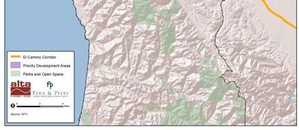
10 Pedestrian nodes MTC Priority Development Areas Pedestrian nodes MTC Priority Development Areas El Camino Corridor: Grand Boulevard Initiative 10


11 Pedestrian nodes MTC Priority Development Areas El Camino Corridor Major downtown plans Communities of Concern Challenges El Camino Real El Camino Real continues to be a corridor with many pedestrian collisions 11


12 Challenges 12 pedestrian fatalities on El Camino Real (24 % of total in last 6 years) Northern part of County contains most fatalities Potential Opportunities Countywide Safe Routes to School Program Safe Routes for Seniors program 12

13 Pedestrian Project Types - Methodology Ped INDEX GIS Process Based on relationship between built environment and walking Walking Demand: Evaluate demand for walking based on GIS factors o o o o Land Use Factors Proximity Factors Demographics Factors Connectivity Factors Pedestrian Project Types - Methodology Pedestrian Deficiencies Disconnected Streets / Missing Connections High Frequency of Collisions Physical Barriers Major Streets with Few Crossing Opportunities Photo: Dan Burden 13


14 Prioritization Potential project types: Pedestrian safety improvements Pedestrian district enhancements Programs Safe Routes to School Insert mode share map County average 0.8% in % in 2008 Menlo Park 2.3% in % in 2008 Lowest collisions per bike commuter 14
15 County averages 236 collisions annually 13 fatalities 1,083 injuries Concentrated on El Camino Real corridor Bike and ped collisions o s follow same pattern Except for a few bike hot spots Half Moon Bay Montara 15


16 2000 Bikeway Network Public meetings Survey 300 responses Connectivity & connection 164 miles/ 47% completed 185 miles still to be completed Proposed Method for Refining Bikeway Network Meet with cities to discuss proposed alignments from 2000 plan Modification due to: Implemented/proposed alternative alignment Multiple parallel alignments one alignment Politically/physically infeasible Destination is not served by 2000 network Alternative alignment meets more criteria 16
17 Criteria to Evaluate and Refine Countywide Network Derived from goals and policies North-south connectivity East-west connectivity Cross-jurisdictional connections Access to destinations of county significance Safety Feasibility Future opportunities Integration into regional network Questions? Questions? 17
San Mateo County Comprehensive Bicycle and Pedestrian Plan Open House
 San Mateo County Comprehensive Bicycle and Pedestrian Plan Open House October 28, 2010 Presented to San Mateo County residents and interested parties by Lauren Ledbetter, Alta Planning + Design Matt Haynes,
San Mateo County Comprehensive Bicycle and Pedestrian Plan
 San Mateo County Comprehensive Bicycle and Pedestrian Plan PUBLIC REVIEW DRAFT February 16, 2011 PREPARED BY: Alta Planning + Design IN ASSOCIATION WITH: Fehr & Peers Eisen Letunic PREPARED FOR: City/County
San Mateo County Bicycle and Pedestrian Advisory Committee
 San Mateo County Bicycle and Pedestrian Advisory Committee January 19, 2017 Emma Shlaes, Policy Manager About SVBC Mission Our purpose is to create a healthy community, environment, and economy through
Presentation Summary Why Use GIS for Ped Planning? What Tools are Most Useful? How Can They be Applied? Pedestrian GIS Tools What are they good for?
 1 2 Pedestrian GIS Tools What are they good for? Pro Walk / Pro Bike 2006 Presentation Summary Why Use GIS for Ped Planning? What Tools are Most Useful? How Can They be Applied? Matt Haynes Fehr & Peers
Bike San Mateo County San Mateo County Bicycle Plan Recommendations August 30, 2010
 Policy and Procedures Develop and Implement a Complete Streets Policy to comply with DD-64-R1 and AB1358 Commencing January 1, 2011, AB1358 requires that the legislative body of a city or county, upon
San Mateo County Comprehensive Bicycle and Pedestrian Plan. Draft Final
 San Mateo County Comprehensive Bicycle and Pedestrian Plan Draft Final August 30, 2011 San Mateo County Comprehensive Bicycle and Pedestrian Plan Acknowledgements C/CAG Bicycle and Pedestrian Advisory
Existing Pedestrian Conditions. PSAC February 8, 2011
 Existing Pedestrian Conditions PSAC February 8, 2011 Contents 1. Project Background & Goals 2. Pedestrian Activity: Where people walk 3. Pedestrian Safety: The conditions people face Project Background
Chapter 14 PARLIER RELATIONSHIP TO CITY PLANS AND POLICIES. Recommendations to Improve Pedestrian Safety in the City of Parlier (2014)
") Chapter 14 PARLIER This chapter describes the current status and future plans for biking and walking in the City of Parlier. RELATIONSHIP TO CITY PLANS AND POLICIES The Parlier General Plan is the primary
Chapter 14 PARLIER This chapter describes the current status and future plans for biking and walking in the City of Parlier. RELATIONSHIP TO CITY PLANS AND POLICIES The Parlier General Plan is the primary
Pedestrian Activity Criteria. PSAC March 8, 2011
 Pedestrian Activity Criteria PSAC March 8, 2011 Contents 1. Project Overview a) Revised schedule of PSAC hearings 2. Pedestrian Activity: Where walking is important a) Existing conditions (revisions based
ADOT Statewide Bicycle and Pedestrian Program Summary of Phase IV Activities APPENDIX B PEDESTRIAN DEMAND INDEX
 ADOT Statewide Bicycle and Pedestrian Program Summary of Activities APPENDIX B PEDESTRIAN DEMAND INDEX May 24, 2009 Pedestrian Demand Index for State Highway Facilities Revised: May 29, 2007 Introduction
Rail Station Fact Sheet CentrePort/DFW Airport Station
 Rail Station Fact Sheet CentrePort/DFW Airport Station Station Overview CentrePort/DFW Airport Station is located by Statler Boulevard at Breezewood Drive in Fort Worth. Free shuttles connect the station
Rail Station Fact Sheet DFW Airport North Station* (*station under construction with anticipated start of service in late 2018)
") Rail Station Fact Sheet DFW Airport North Station* (*station under construction with anticipated start of service in late 018) Station Overview DFW Airport North Station will be located on DFW nternational
Rail Station Fact Sheet DFW Airport North Station* (*station under construction with anticipated start of service in late 018) Station Overview DFW Airport North Station will be located on DFW nternational
TABLE OF CONTENTS. Executive Summary
 Executive Summary Background... ES-1 Pedestrian Network... ES-2 Bikeway Network... ES-2 Collision History... ES-2 Public Input... ES-4 Conclusions and Recommendations... ES-4 1. Introduction and Setting
FROM: CITY MANAGER DEPARTMENT: PLANNING AND COMMUNITY ENVIRONMENT DATE: OCTOBER 4, 2004 CMR:432:04
 TO: HONORABLE CITY COUNCIL FROM: CITY MANAGER DEPARTMENT: PLANNING AND COMMUNITY ENVIRONMENT DATE: OCTOBER 4, 2004 CMR:432:04 SUBJECT: FINANCE COMMITTEE RECOMMENDATION TO ADOPT TRANSPORTATION STRATEGIC
Rail Station Fact Sheet Downtown Carrollton Station
 Rail Station Fact Sheet Downtown Carrollton Station Station Overview Downtown Carrollton Station is located at East Belt Line Road and Broadway Street near the historic Downtown Carrollton Square. The
EXECUTIVE SUMMARY... vii 1 STUDY OVERVIEW Study Scope Study Area Study Objectives
 Contents EXECUTIVE SUMMARY... vii 1 STUDY OVERVIEW... 1-1 1.1 Study Scope... 1-1 1.2 Study Area... 1-1 1.3 Study Objectives... 1-3 2 EXISTING CONDITIONS... 2-1 2.1 Existing Freeway Conditions... 2-4 2.1.1
TRANSPORTATION MASTER PLAN Review Citywide Recommendations, Updated List and Scoring Methodology December 6, 2018
 NOTE: Due to lengthy Committee discussion and allotted meeting time, slides 12-35 were not presented at the meeting, but are provided here for reference. TRANSPORTATION MASTER PLAN Review Citywide Recommendations,
Regional Bicycle System Master Study. Preliminary Results Update
 Regional Bicycle System Master Study Preliminary Results Update Transportation Committee October 21, 2013 Introduction Study Goals Guiding Principles Bicycle Study System Elements Analysis Approach Proposed
AGENDA ITEM G-2 Public Works
 AGENDA ITEM G-2 Public Works STAFF REPORT City Council Meeting Date: 12/6/2016 Staff Report Number: 16-214-CC Regular Business: Approve the Oak Grove University Crane Bike Improvement Concept Plan, authorize
Moving Ahead. (Community Engagement) Chapter Three
 Chapter Three") 3 Community Chapter Three Moving Ahead (Community Engagement) engagement provided an exciting opportunity to engage Redwood City residents, workers, and business owners people who walk, bike, take transit,
3 Community Chapter Three Moving Ahead (Community Engagement) engagement provided an exciting opportunity to engage Redwood City residents, workers, and business owners people who walk, bike, take transit,
South King County High-Capacity Transit Corridor Study
 HIGH-CAPACITY TRANSIT CORRIDOR STUDY South King County Corridor South King County High-Capacity Transit Corridor Study Corridor Report August 2014 South King County High Capacity Transit Corridor Report
Magnolia Place. Traffic Impact Analysis. Prepared for: City of San Mateo. Prepared by: Hexagon Transportation Consultants, Inc.
 Magnolia Place Traffic Impact Analysis Prepared for: City of San Mateo Prepared by: Hexagon Transportation Consultants, Inc. Updated January 4, 2010 Table of Contents 1. Introduction...1 2. Existing Conditions...6
Public Works AGENDA ITEM D-2 STAFF REPORT
 AGENDA ITEM D-2 Public Works STAFF REPORT Transportation Master Plan Oversight and Outreach Committee Meeting Date: 10/30/2017 Staff Report Number: 17-001-TMP Regular Business: Provide feedback on Performance
Chapter 13 ORANGE COVE
 Chapter 13 ORANGE COVE This chapter describes the current status and future plans for biking and walking in the City of Orange Cove. RELATIONSHIP TO CITY PLANS AND POLICIES The Orange Cove General Plan
Key objectives of the survey were to gain a better understanding of:
 3 COMMUNITY INPUT Community input is an essential part of corridor studies. For the SR 87 corridor study, VTA staff conducted an extensive online survey of people living and commuting along the corridor.
WALKNBIKE DRAFT PLAN NASHVILLE, TENNESSEE EXECUTIVE SUMMARY NASHVILLE, TENNESSEE
 NASHVILLE, TENNESSEE EXECUTIVE SUMMARY Executive Summary A world-class multi-modal transportation system is essential to a vibrant city and better quality of life. -Mayor Barry The WalknBike plan aims
Arterial Transitway Corridors Study. Ave
 Arterial Transitway Corridors Study Ave January 2012 Arterial Transitway Corridors Study Overview Corridor Features and Demographics 11 study corridors, 95 route miles 86,000 daily rides and half of existing
Rail Station Fact Sheet University of Dallas Station
 Rail Station Fact Sheet University of Dallas Station Station Overview University of Dallas Station is located on John Carpenter Freeway and west of Loop 12 across from the University of Dallas in Irving.
Orinda Bicycle, Trails and Walkways Master Plan
 Orinda Bicycle, Trails and Walkways Master Plan Public Meeting October 15, 2008 Presented by: Ian Moore, Alta Lauren Ledbetter, Alta Bruce Wolff, Alta Introductions City of Orinda Monica Pacheco, Assistant
Improving Pedestrian Access to Transit: The Sacramento Pedestrian Master Plan
 Improving Pedestrian Access to Transit: The Sacramento Pedestrian Master Plan Matt Haynes Fehr & Peers Associates San Francisco, California Rail~Volution 2005 Presentation Outline Policies What are most
Rail Station Fact Sheet UNT Dallas Station
 Rail Station Fact Sheet UNT Dallas Station Station Overview UNT Dallas Station is located on the east side of University Hills Boulevard in Dallas. t is connected by a walking path to the University of
City of San Mateo Bicycle Master Plan. Adopted October 17, PREPARED BY: Alta Planning + Design. PREPARED FOR: The City of San Mateo
 City of San Mateo Bicycle Master Plan Adopted October 17, 2011 PREPARED BY: Alta Planning + Design PREPARED FOR: The City of San Mateo City of San Mateo Bicycle Master Plan Adopted October 17, 2011 Updated
SAN BENITO COUNTY Bikeway and Pedestrian Master Plan
 SAN BENITO COUNTY Bikeway and Pedestrian Master Plan Prepared for: Council of San Benito County Governments Prepared by: Alta Planning + Design December 2009 ACKNOWLEDGEMENTS Council of San Benito County
4.3 TRAFFIC. Introduction. Approach and Methodology
 4.3 TRAFFIC Introduction This section summarizes a transportation study conducted for the proposed Corridor Plan and the Bay Meadows project prepared by Hexagon Transportation Consultants, Inc. 1 Copies
MEMORANDUM. Sutter Street Bicycle Lanes, Stockton, CA SF
 MEMORANDUM Date: To: From: Subject: PURPOSE Anthony J. Lopes, Siegfried Engineering Christine Carey & Matthew Ridgway, Fehr & Peers Sutter Street Bicycle Lanes, Stockton, CA SF09-0468 The City of Stockton
2010 Pedestrian and Bicyclist Special Districts Study Update
 2010 Pedestrian and Bicyclist Special Districts Study Update Pedestrian and Bicyclist Special Districts Program Overview H-GAC s Special Districts Program aims to provide strategic investments in pedestrian
Berkeley Strategic Transportation Plan A-76
 Berkeley Strategic Transportation Plan A-76 Appendices 1. A Team Effort 2. Where We ve Been A-11 Berkeley Strategic Transportation Plan Alameda County Transportation Plan Alameda County will be served
Access BART: TOD and Improved Connections. October 29, 2008
 Access BART: TOD and Improved Connections October 29, 2008 1 Access BART Study Goals Evaluate at the system-level land use and access scenarios to optimize ridership Identify station clusters that provide
Get Us Moving Update. June 2018
 Get Us Moving Update June 2018 Community Engagement 2 Outreach by the Numbers $12 Billion in need identified through a call for projects process 7 Million Get Us Moving impressions on digital and social
UPDATING THE WEST COUNTY ACTION PLAN
 UPDATING THE WEST COUNTY ACTION PLAN Presentation to the WCCTAC Technical Advisory Committee Presented By: In Association With: DKS CH2M HILL Dyett & Bhatia Eisen Letunic February 14, 2013 The Consultant
5.13 Soledad. Demographic Profile. Disadvantaged Communities. Safety Profile
 5.13 Soledad Demographic Profile The City of Soledad is a small town in the Salinas Valley with 26,065 people, as reported by the California Department of Finance 2017 data. Soledad is a relatively young,
101 Corridor Managed Lanes
 101 Corridor Managed Lanes TA BOD Meeting May 5, 2016 Agenda Item 11a Presentation Outline 101 Corridor Profile System Deficiencies Background Managed Lanes Proposed Purpose and Need Alternatives Under
Central Freeway and Octavia Circulation Study
 Central Freeway and Octavia Circulation Study Final Report Plans and Programs Committee San Francisco County Transportation Authority September 18, 2012 Presentation Outline Background and Study Purpose
SANTA CLARA COUNTYWIDE BICYCLE PLAN August 2008
 SANTA CLARA COUNTYWIDE BICYCLE PLAN August 2008 To assist VTA and Member Agencies in the planning, development and programming of bicycle improvements in Santa Clara County. Vision Statement To establish,
I-105 Corridor Sustainability Study (CSS)
") I-105 Corridor Sustainability Study (CSS) Metro Streets and Freeways Subcommittee March 21, 2019 Gary Hamrick Cambridge Systematics, Inc. I-105 CSS Project History & Background Funded by Caltrans Sustainable
I-105 Corridor Sustainability Study (CSS) Metro Streets and Freeways Subcommittee March 21, 2019 Gary Hamrick Cambridge Systematics, Inc. I-105 CSS Project History & Background Funded by Caltrans Sustainable
Pedestrian Project List and Prioritization
 To: Kyle Wagenschutz, City of Memphis CC: From: Anne Conlon and John Cock, Alta Planning + Design Date: December, 2014 Re: Project List Development (Task 3.1-3.2) and Project List Prioritization (Task
Beyond First First Last Last Mile Strategies. APA National Conference April 3, 2016 Chelsea Richer, AICP Fehr & Peers
 Beyond First First Last Last Mile Strategies APA National Conference April 3, 2016 Chelsea Richer, AICP Fehr & Peers 1 Beyond First Last Mile Strategies APA National Conference Jeremy Klop, AICP, Fehr
Downtown Naples Mobility and Connectivity Study. Naples City Council Presentation January 2017
 Downtown Naples Mobility and Connectivity Study Naples City Council Presentation January 2017 Agenda 1. Introduction 2. Scope Review 3. Project Schedule 4. Existing Conditions 5. Public Charrette 6. Mobility
Oakland Pedestrian Master Plan Oakland Pedestrian Plan Draft Recommendations Chapter Outline
 EISEN LETUNIC T R A N S P O R T A T I O N, ENVIRO N M E N TA L A N D URBAN PLANNIN G MEMORANDUM To Oakland Pedestrian Plan Technical Advisory Committee & Pedestrian Advisory Group From Victoria Eisen Date
Rail Station Fact Sheet Downtown Denton Transit Center
 Rail Station Fact Sheet Downtown Denton Transit Center Station Overview The Euline Brock Downtown Denton Transit Center is located on East Hickory Street at Railroad Street in Denton near the historic
CITY OF LOS ALTOS Bicycle Transportation Plan Update. Prepared by: Alta Planning + Design April 2011
 CITY OF LOS ALTOS Bicycle Transportation Plan Update Prepared by: Alta Planning + Design April 2011 Bicycle Transportation Plan April 2011 Prepared by: Alta Planning + Design, Inc. In Partnership with:
Tulsa Metropolitan Area LONG RANGE TRANSPORTATION PLAN
 Tulsa Metropolitan Area LONG RANGE TRANSPORTATION PLAN Indian Nations Council of Governments August 2005 CONTACTING INCOG In developing the Destination 2030 Long Range Transportation Plan, INCOG s Transportation
Methodology for Determining Pedestrian Activity Factors
 Where People Walk: Methodology for Determining Pedestrian Activity Factors Part I: Background on the WalkFirst Project The goal of the WalkFirst project is to improve walking conditions in San Francisco,
General Plan Circulation Element Update Scoping Meeting April 16, 2014 Santa Ana Senior Center, 424 W. 3rd Street, Santa Ana, CA 92701
 General Plan Circulation Element Update Scoping Meeting April 16, 2014 Santa Ana Senior Center, 424 W. 3rd Street, Santa Ana, CA 92701 Meeting Agenda 1. Purpose of Scoping Meeting 2. Project Overview 3.
San Jose Transportation Policy
 San Jose Transportation Policy Protected Intersections in LOS Policies to Support Smart Growth Presented by: Manuel Pineda City of San Jose Department of Transportation Bay Area Map San Francisco Oakland
Moraga Pedestrian and Bicycle Master Plan Update and Wayfinding Plan. Citizens Advisory Committee Meeting July 21, 2015
 Moraga Pedestrian and Bicycle Master Plan Update and Wayfinding Plan Citizens Advisory Committee Meeting July 21, 2015 Planning process Inventory of existing conditions 2 of 21 Planning process Inventory
PEDESTRIAN ACTION PLAN
 CITY OF SANTA MONICA PEDESTRIAN ACTION PLAN DRAFT OCTOBER 2015 Safe Streets Santa Monica, December 3, 2015 Beth Rolandson, AICP Principal Transportation Planner Strategic + Transportation Planning, Planning
Bike/Multipurpose Trail Study for Glynn County, Georgia MAY 16, 2016
 Bike/Multipurpose Trail Study for Glynn County, Georgia MAY 16, 2016 Agenda» Project Status Update» Draft Recommendations Overview» Next Steps» Questions/Discussion Project Overview» Comprehensive Bikeway
REDWOOD CITY STREETCAR - ALTERNATIVES ANALYSIS
 REDWOOD CITY STREETCAR - ALTERNATIVES ANALYSIS The purpose of this document is to ennumerate the analysis of alternatives for a streetcar along the Broadway Corriodor of Redwood City. The six alternatives
Appendix C. Corridor Spacing Research
 Appendix C. Corridor Spacing Research Task 3 of the Twin Cities Bicycle Study called for the development of bicycle corridor spacing guidelines. This section summarizes research of the spacing of planned
PEDESTRIAN ACTION PLAN
 CITY OF SANTA MONICA PEDESTRIAN ACTION PLAN DRAFT OCTOBER 2015 City Council, February 23, 2016 Beth Rolandson, AICP Principal Transportation Planner Mobility Division, Planning and Community Development
MASTER BICYCLE AND PEDESTRIAN PLAN
 VILLAGE OF NORTHBROOK MASTER BICYCLE AND PEDESTRIAN PLAN DRAFT PLAN OPEN HOUSE May 2, 2018 AGENDA 1. Community Engagement 2. Vision and Goals 3. General Structure of Plan 4. Recommendations Overview 5.
TRANSPORTATION TRAINING TOPICS. April 6, 2010
 TRANSPORTATION TRAINING TOPICS April 6, 2010 Roles of Transportation Providers Context and Policy Makers Division of Transportation and Traffic Other City Operations Other Transportation Operators CMA
A copy of the draft plan is available at:
 To: From: Re: Mayor and City Council Patricia Nilsson, AICP, Comprehensive Planning Manager Boise Central Bench Neighborhood Pedestrian and Bicycle Plan Date: August 24, 2012 Requested Action Provide comments
Balboa Area Transportation Demand Management
 Balboa Area Transportation Demand Management April 2016 Presented by: Jeff Tumlin What Are We Aiming For? Transportation is not an end in itself. It is merely a means by which we support the community.
REVIEW OF LOCAL TRAFFIC FLOW / LONG RANGE PLANNING SOLUTIONS STUDY
 ITEM Town of Atherton TRANSPORTATION COMMITTEE STAFF REPORT TO: FROM: MEMBERS OF THE COMMITTEE ROBERT OVADIA, PUBLIC WORKS DIRECTOR DATE: FEBRUARY 12, 2019 SUBJECT: REVIEW OF LOCAL TRAFFIC FLOW / LONG
Dumbarton Transportation Corridor Study. San Francisco Bay ITE November 2016
 Dumbarton Transportation Corridor Study San Francisco Bay ITE November 2016 Dumbarton Corridor Source: Wikipedia 2 Dumbarton Corridor 3 Growth Imbalance Jobs-housing imbalance Major employers driving growth
Memorandum. Fund Allocation Fund Programming Policy/Legislation Plan/Study Capital Project Oversight/Delivery Budget/Finance Contract/Agreement Other:
 Memorandum Date: November 20, 2017 To: Transportation Authority Board From: Eric Cordoba Deputy Director Capital Projects Subject: 12/5/17 Board Meeting: San Francisco Freeway Corridor Management Study
SF Transportation Plan Update
 SF Transportation Plan Update CAC Meeting #11 Existing Conditions and Future Baseline Needs Revised, Part I www.sfcta.org/movesmartsf twitter.com/sanfranciscota www.facebook.com/movesmartsf January 30,
summary of issues and opportunities
 1 summary of issues and opportunities EXECUTIVE SUMMARY CHAPTER 2: HISTORY - 3: LAND USE This first chapter is an overview of lessons learned from analysis of the existing conditions on El Camino as well
3.3 Transportation/Traffic
 3.3 This section provides an evaluation of traffic and transportation related to the proposed Commonwealth Corporate Center Project. The Project site is accessible from Commonwealth rive and Jefferson
SNCC Demographic Trends
 Employment Population SNCC Demographic Trends In 1970 the SNCC population was 10,040, accounting for roughly 3% of the County population In 2015, SNCC grew to 60,567 people, roughly 11% of the County population
Hennepin County Bicycle and Pedestrian Planning
 Hennepin County Bicycle and Pedestrian Planning 1 Value of bicycle and sidewalk systems Safety Livability Mobility Health Personal Finances Economic Sustainability Clean Air Recreation Parking and congestion
SAN MATEO COUNTY TRANSPORTATION AUTHORITY STAFF REPORT
 SAN MATEO COUNTY TRANSPORTATION AUTHORITY STAFF REPORT AGENDA ITEM # 10 (a) MARCH 3, 2016 TO: THROUGH: Transportation Authority Jim Hartnett Executive Director FROM: April Chan Eli Kay Gigi Harrington
Bicycle Master Plan for Greenville, SC Presentation to City Council June 13, 2011
 Bicycle Master Plan for Greenville, SC Presentation to City Council June 13, 2011 In collaboration with: Alta Planning + Design Fuss & O Neill Darrohn Engineering DNA Creative Bicycle Master Plan Advisory
Millbrae Serra Station Development Millbrae, California
 Millbrae Serra Station Development Millbrae, California Transportation Demand Management Plan Prepared for: Mr. Vincent A. Muzzi, Millbrae Serra Station, LLC June 15, 2016 Hexagon Transportation Consultants,
TRANSIT & NON-MOTORIZED PLAN DRAFT FINAL REPORT Butte County Association of Governments
 1 INTRODUCTION Maintaining a high quality of life is the essence of this plan for transit and non-motorized transportation in Butte County. Curbing greenhouse gas emissions (GHG) by reducing congestion,
City of Menlo Park Sidewalk Master Plan
 City of Menlo Park Sidewalk Master Plan Prepared for: Prepared by: 180 Grand Avenue, Suite 250 Oakland, CA 94612 Phone: (510) 839-1742; Fax: (510) 839-0871 www.dowlinginc.com January 28, 2009 Dowling
1.0 INTRODUCTION 1.1 PURPOSE OF THIS REPORT
 1.0 INTRODUCTION This chapter provides an overview of the purpose, authorization and focus of this Recirculated Draft Environmental Impact Report (EIR), an identification of the Lead Agency, an outline
Urbana Pedestrian Master Plan
 Urbana Pedestrian Master Plan Recommendations Gabe Lewis, Transportation Planner Champaign County Regional Planning Commission November 15, 2018 Public Meeting #2 Public Input Round #1 Thank You! 10 public
 MEMORANDUM - CITY OF PASADENA Department Of Transportation DATE: OCTOBER 21, 2008 TO: ENVIRONMENTAL ADVISORY COMMISSION FROM: ~ FRED C. DOCK, DIRECTOR OF TRANSPORTATION SUBJECT: UPDATE ON DEPT. OF TRANSPORTATION
Rail Station Fact Sheet Buckner Station
 Rail Station Fact Sheet Buckner Station Station Overview Buckner Station is located at the intersection of Buckner Boulevard and Elam Road in Dallas. The station opened in 2010 and currently serves as
CITY OF COCOA BEACH 2025 COMPREHENSIVE PLAN. Section VIII Mobility Element Goals, Objectives, and Policies
 CITY OF COCOA BEACH 2025 COMPREHENSIVE PLAN Section VIII Mobility Element Goals, Objectives, and Policies Adopted August 6, 2015 by Ordinance No. 1591 VIII MOBILITY ELEMENT Table of Contents Page Number
El Camino Real Bus Rapid Transit Conceptual Engineering. Los Altos Council Workshop January 24, 2012
 El Camino Real Bus Rapid Transit Conceptual Engineering Los Altos Council Workshop January 24, 2012 Agenda Introduction Growth in the El Camino Real Corridor Benefits of BRT El Camino Real BRT Decision
Bicycle and Pedestrian Planning in a Historically Car-Centric Culture: A Focus on Connectivity, Safety, & Accessibility
 Bicycle and Pedestrian Planning in a Historically Car-Centric Culture: A Focus on Connectivity, Safety, & Accessibility Kate Horton and Zylavian Watley Transportation Planners Memphis MPO Date: October
CPC Parking Lot Riverside Drive. Transportation Rationale
 CPC Parking Lot Transportation Rationale Prepared By: NOVATECH Suite 200, 240 Michael Cowpland Drive Ottawa, Ontario K2M 1P6 September 2015 Novatech File: 114093 Ref: R-2015-153 Table of Contents 1.0 INTRODUCTION...
Data Analysis February to March 2018 Identified safety needs from reported collisions and existing travel patterns. SFMTA Board of
 Welcome! Thank you for participating in today s Valencia Data Analysis February to March 2018 Identified safety needs from reported collisions and existing travel patterns. First Community Event(s) July
Intro Strategic Plan SFTP TDM Facilities Transit Bicycle Pedestrian Taxi BICYCLE UPDATE. Presented by Timothy Papandreou, Strategic Planning & Policy
 BICYCLE UPDATE Presented by Timothy Papandreou, Strategic Planning & Policy 114 Strategic Goals & Objectives Goal 1: Create a safer transportation experience for everyone Objective 1.3: Improve the safety
CITY OF MILLBRAE. Amendment to the Circulation Element of the General Plan BICYCLE AND PEDESTRIAN TRANSPORTATION PLAN. August 2009
 CITY OF MILLBRAE Amendment to the Circulation Element of the General Plan BICYCLE AND PEDESTRIAN TRANSPORTATION PLAN August 2009 Prepared by City of Millbrae Community Development Department Planning Division
Welcome and Introductions Overview of the Study to Date Community Involvement Intersection Improvement Concepts Bike-Ped Recommendations ITS
 Welcome and Introductions Overview of the Study to Date Community Involvement Intersection Improvement Concepts Bike-Ped Recommendations ITS Recommendations Transit Recommendations Next Steps Inventoried
City of Bakersfield. Bicycle Transportation Plan. Prepared by: In Partnership with: Prepared for: Alta Planning and Design
 City of Bakersfield Bicycle Transportation Plan Prepared by: Alta Planning and Design In Partnership with: Ruettgers & Schuler Civil Engineers Prepared for: City of Bakersfield The development of the Bicycle
Bike+Rail in the Bay Area
 Bike+Rail in the Bay Area Andy Thornley San Francisco Bicycle Coalition The Last Green Mile Sustainable ways to complete the rail trip Rail~Volution, San Francisco, California Wednesday, October 29, 2008
Castro Valley Municipal Advisory Council March 19, 2018
 Castro Valley Municipal Advisory Council March 19, 2018 1 Background 2 Draft Bicycle Vision and Pedestrian Networks 3 Next Steps 4 Updates Agenda 2 PROJECT AREA: Unincorporated Areas of Alameda County
Telegraph Avenue Complete Streets DRAFT Recommendations. Oakland Public Works Department September 11 and 13, 2014 Open Houses
 Telegraph Avenue Complete Streets DRAFT Recommendations Oakland Public Works Department September 11 and 13, 2014 Open Houses Presentation Overview What are complete streets? What problem are we trying
Living Streets Policy
 Living Streets Policy Introduction Living streets balance the needs of motorists, bicyclists, pedestrians and transit riders in ways that promote safety and convenience, enhance community identity, create
B. TRANSPORTATION, CIRCULATION AND PARKING
 FEBRUARY 0 89 EL CAMINO REAL PROJECT EIR This section describes the existing traffic, circulation, parking, and transit conditions in the vicinity of the project site and provides an analysis of the project
Bicycle Master Plan Goals, Strategies, and Policies
 Bicycle Master Plan Goals, Strategies, and Policies Mobilizing 5 This chapter outlines the overarching goals, action statements, and action items Long Beach will take in order to achieve its vision of
Rail Station Fact Sheet Highland Village/Lewisville Lake Station
 ail Station Fact Sheet Highland Village/Lewisville Lake Station Station Overview Highland Village/Lewisville Lake Station is located on the IH 35 E Northbound Frontage oad at Garden idge Boulevard in Lewisville.
4.13 TRANSPORTATION AND TRAFFIC
 4.13 This chapter describes the regulatory framework and existing conditions in the vicinity of the Project site related to transportation and traffic, and the potential impacts of the proposed Project
REGULAR MEETING of the San Mateo County Bicycle and Pedestrian Advisory Committee (SMCBPAC) Thursday, October 20, 2016
 Thursday, October 20, 2016") REGULAR MEETING of the San Mateo County Bicycle and Pedestrian Advisory Committee (SMCBPAC) Thursday, October 20, 2016 San Mateo City Hall 330 West 20 th Street, Conference Room A City of San Mateo, California
REGULAR MEETING of the San Mateo County Bicycle and Pedestrian Advisory Committee (SMCBPAC) Thursday, October 20, 2016 San Mateo City Hall 330 West 20 th Street, Conference Room A City of San Mateo, California