Presentation Summary Why Use GIS for Ped Planning? What Tools are Most Useful? How Can They be Applied? Pedestrian GIS Tools What are they good for?
|
|
|
- Vanessa Baker
- 6 years ago
- Views:
Transcription
1 1 2 Pedestrian GIS Tools What are they good for? Pro Walk / Pro Bike 2006 Presentation Summary Why Use GIS for Ped Planning? What Tools are Most Useful? How Can They be Applied? Matt Haynes Fehr & Peers San Francisco 1

2 3 4 Presentation Summary Why Use GIS for Ped Planning? What Tools are Most Useful? How Can They be Applied? Why Use GIS? Definition of GIS: Computerized systems for the storage, retrieval, manipulation, analysis, and display of geographically referenced data 2
3 5 6 Why Use GIS: Arguments For Spatial Representation of Data Mapping Census JTW data, collision statistics Policy areas Networks, routes, proposed pathways Analytical techniques (e.g. buffering) GIS Mapping Walking Distance to Transit 3


4 7 8 Why Use GIS: Arguments For Flexibility in Collecting and Updating Data Modeling Applications Use of multiple input factors Complex calculations Why Use GIS: Arguments Against Cost Software Data collection and translation Learning curve Complex, requires training Time Maintaining large amounts of data can be time consuming 4
5 9 10 Presentation Summary Why Use GIS for Ped Planning? What Tools are Most Useful? How Can They be Applied? Tools vs. Techniques Techniques (Display of Data) Mapping Buffering Queries Tools (Manipulation and Analysis of Data) Combination of multiple factors 5


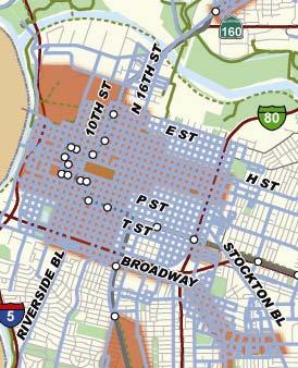
6 11 12 Techniques: Mapping Safety Collision Analysis Techniques: Buffering Safety School Zones Source: City of Oakland Pedestrian Master Plan Source: City of Oakland Pedestrian Master Plan 6

7 13 14 Techniques: Buffering Transit Station Walksheds GIS Tools for Pedestrian Planning Route and Slope Analysis Automated Data Collection Modeling Pedestrian Demand Estimation Demand/Deficiency Analysis 7

8 15 16 Routes and Slope Analysis Routes and Slope Analysis 8


9 17 18 Routes and Slope Analysis Automated Data Collection Handheld Devices GPS Equipped Programmable 9
10 19 20 Tools for Pedestrian Modeling: 3 Questions 1. Usage: How many? 2. Marginal Change in Usage: How many more would there be if? 3. Deficiencies: Where are underserved areas? Tools: Demand Estimation Could answer questions #1 and #2: (How many? How many more would there be if?) Many past efforts at measuring demand (both bike and ped) Traditional 4-step models Mode specific models Complications due to complex nature of pedestrian demand Has led to sketch planning level estimates of ped usage 10
11 21 22 Tools: Demand Estimation GIS offers ability to further develop demand tools Research on factors influencing demand land use element Research on network topology structural element Recent efforts University of Maryland UK Tools: Demand Estimation Challenges Intensive data collection Derivation of rates by land use Pedestrian counts for model calibration costly Relationships contain unmeasured factors (e.g. history, culture) Does not answer question #3: Where are there underserved areas? An important question for bike/ped planners 11

12 23 24 Tools: Integrating Demand and Deficiencies Moves away from directly predicting demand Relative vs. absolute values Answers question #3 Where are there underserved areas? Tools: Demand and Deficiencies Premise is that areas with high demand and few facilities are underserved 12

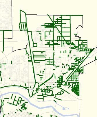
13 25 26 Presentation Summary Why Use GIS for Ped Planning? What Tools are Most Useful? How Can They be Applied? GIS Modeling Applications Sacramento Pedestrian Master Plan: PedINDEX tool 13
14 27 28 Example Application: Sacramento PedINDEX GIS tool Based on EPA s Smart Growth Index research Demand: Identified factors correlated with the likelihood to walk Related to 4D s research: Density Diversity Design of neighborhood Distance to transit Deficiency: Based on city s GIS system Pedestrian Demand The nature of a place that attracts pedestrians Demand influenced by: Land use: mixes and intensities of uses Public spaces and parks Transit 14

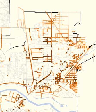
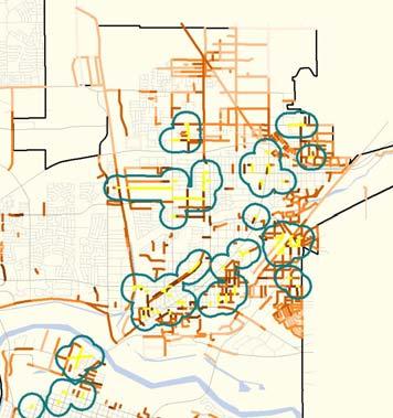
15 29 30 Sacramento Pedestrian Demand Measures of pedestrian demand (15 factors mapped in GIS): Population density Transit proximity Employment density Land use mix Proximity to Schools, parks, community centers, shopping areas Age / socioeconomic factors Pedestrian Deficiency The ease, comfort, and safety of walking Walkability depends on the condition of the infrastructure Low walkability means a deficient pedestrian infrastructure 15

16 31 32 High walkability Low walkability 16
: Sidewalks Street connectivity Street width Traffic signals Hazards")

17 33 34 Sacramento Deficiencies Measured infrastructure deficiencies (6 factors mapped in GIS): Sidewalks Street connectivity Street width Traffic signals Hazards / collisions Street lighting Sacramento Improvement Needs Highest Priority Areas: Putting facilities where they are needed the most Demand Deficiencies Improvement Need 17
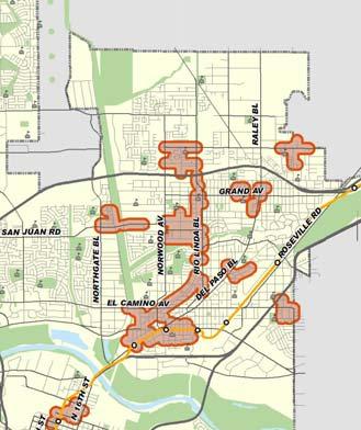
18 35 36 Sacramento Ped Master Plan Policy Areas Ped Zones Sidewalk Prioritization BASIC UPGRADED PREMIUM 18


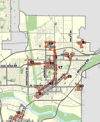
19 37 38 Sidewalk Improvement Projects Street Crossing Candidate Improvements 19
20 39 40 Lessons Learned Variety of tools available GIS can be a particularly useful prioritization tool But cannot ignore community input Readily available data sources Demand data generally straightforward to compile (Census, City land use data) Deficiencies data can use proxy variables Adaptability Thank You! Matt Haynes, PE, AICP Fehr & Peers San Francisco, CA m.haynes@fehrandpeers.com 20
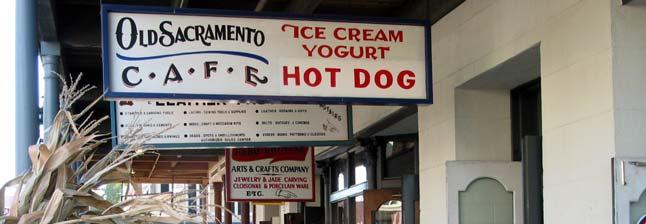
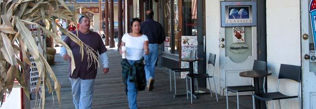
Improving Pedestrian Access to Transit: The Sacramento Pedestrian Master Plan
 Improving Pedestrian Access to Transit: The Sacramento Pedestrian Master Plan Matt Haynes Fehr & Peers Associates San Francisco, California Rail~Volution 2005 Presentation Outline Policies What are most
San Mateo County Comprehensive Bicycle and Pedestrian Plan Open House
 San Mateo County Comprehensive Bicycle and Pedestrian Plan Open House October 28, 2010 Presented to San Mateo County residents and interested parties by Lauren Ledbetter, Alta Planning + Design Matt Haynes,
San Mateo County Comprehensive Bicycle and Pedestrian Plan
 San Mateo County Comprehensive Bicycle and Pedestrian Plan August 26, 2010 Presented to the San Mateo County BPAC by Lauren Ledbetter, Alta Planning + Design in association with: Fehr & Peers Eisen Letunic
GIS Based Data Collection / Network Planning On a City Scale. Healthy Communities Active Transportation Workshop, Cleveland, Ohio May 10, 2011
 The Purpose of GIS Based Network Planning GIS Based Data Collection / Network Planning Healthy Communities Active Transportation Conference Tuesday, May 10, 2011 10:00 AM Norman Cox, LLA, ASLA. Ann Arbor,
Existing Pedestrian Conditions. PSAC February 8, 2011
 Existing Pedestrian Conditions PSAC February 8, 2011 Contents 1. Project Background & Goals 2. Pedestrian Activity: Where people walk 3. Pedestrian Safety: The conditions people face Project Background
ADOT Statewide Bicycle and Pedestrian Program Summary of Phase IV Activities APPENDIX B PEDESTRIAN DEMAND INDEX
 ADOT Statewide Bicycle and Pedestrian Program Summary of Activities APPENDIX B PEDESTRIAN DEMAND INDEX May 24, 2009 Pedestrian Demand Index for State Highway Facilities Revised: May 29, 2007 Introduction
GIS Based Non-Motorized Transportation Planning APA Ohio Statewide Planning Conference. GIS Assisted Non-Motorized Transportation Planning
 The Purpose of GIS Assisted Network GIS Assisted Non-Motorized Transportation 2011 APA Ohio Statewide Conference Friday, 10:45 AM to Noon Focus on near-term projects wwwgreenwaycollabcom The purpose of
Memorandum. Drive alone
 Memorandum To: Cc: From: Kimberly Kerr, Assistant Chief Administrative Officer Natalie Porter, PE, TE Shawna Purvines Claudia Wade, PE Michael Schmitt, AICP CTP, PTP Re: Technical Memorandum #2: Model
Traffic Safety. Norman W. Garrick. Wesley Marshall. University of Connecticut. University of Colorado Denver
 Traffic Safety and the Smart Growth Street Network Norman W. Garrick University of Connecticut Wesley Marshall University of Colorado Denver What Does a Smart Growth Street Network look Like? Or this?
Pedestrian Demand Modeling: Evaluating Pedestrian Risk Exposures
 Pedestrian Demand Modeling: Evaluating Pedestrian Risk Exposures Kelly J. Clifton National Center for Smart Growth University of Maryland May 19, 2008 Study Team University of Maryland National Center
Pedestrian Activity Criteria. PSAC March 8, 2011
 Pedestrian Activity Criteria PSAC March 8, 2011 Contents 1. Project Overview a) Revised schedule of PSAC hearings 2. Pedestrian Activity: Where walking is important a) Existing conditions (revisions based
Frequently asked questions about how the Transport Walkability Index was calculated are answered below.
 Transport Walkability Index The Transport Walkability Index is a relative indicator of how well the built environment in different areas supports walking for transport. The index is frequently used in
Designing a Bicycle and Pedestrian Count Program in Blacksburg, VA
 Designing a Bicycle and Pedestrian Count Program in Blacksburg, VA Steve Hankey (Virginia Tech) Andrew Mondschein (U or Virginia) Ralph Buehler (Virginia Tech) Issue/objective Issue No systematic traffic
Kevin Proft NRS 509 Final Project: Written Overview & Annotated Bibliography GIS Applications in Active Transportation Planning
 Kevin Proft NRS 509 Final Project: Written Overview & Annotated Bibliography 12.13.16 GIS Applications in Active Transportation Planning Geographic Information Systems (GIS) play an important role in developing
Bicycle and Pedestrian Connectivity Study. Old Colony Planning Council
 Bicycle and Pedestrian Connectivity Study Old Colony Planning Council Outline Why consider bike/peds in road designs? Why are measures needed? Connecting Land Use with Transportation Evaluation Tools:
2010 Pedestrian and Bicyclist Special Districts Study Update
 2010 Pedestrian and Bicyclist Special Districts Study Update Pedestrian and Bicyclist Special Districts Program Overview H-GAC s Special Districts Program aims to provide strategic investments in pedestrian
Pedestrian Project List and Prioritization
 To: Kyle Wagenschutz, City of Memphis CC: From: Anne Conlon and John Cock, Alta Planning + Design Date: December, 2014 Re: Project List Development (Task 3.1-3.2) and Project List Prioritization (Task
Temporal and Spatial Variation in Non-motorized Traffic in Minneapolis: Some Preliminary Analyses
 Temporal and Spatial Variation in Non-motorized Traffic in Minneapolis: Some Preliminary Analyses Spencer Agnew, Jason Borah, Steve Hankey, Kristopher Hoff, Brad Utecht, Zhiyi Xu, Greg Lindsey Thanks to:
Cultivating Senior Advocacy for Healthy & Walkable Neighborhoods. Jaime Fearer, AICP Planning & Policy Manager
 Cultivating Senior Advocacy for Healthy & Walkable Neighborhoods Jaime Fearer, AICP Planning & Policy Manager www.californiawalks.org @CaliforniaWalks Presenter Disclosures Jaime Fearer The following personal
Summary Report: Built Environment, Health and Obesity
 Research and education Built Environment Edmonton Project Summary Report: Built Environment, Health and Obesity Introduction In 2007 the Canadian Institutes of Health Research and the Heart and Stroke
EXECUTIVE SUMMARY... vii 1 STUDY OVERVIEW Study Scope Study Area Study Objectives
 Contents EXECUTIVE SUMMARY... vii 1 STUDY OVERVIEW... 1-1 1.1 Study Scope... 1-1 1.2 Study Area... 1-1 1.3 Study Objectives... 1-3 2 EXISTING CONDITIONS... 2-1 2.1 Existing Freeway Conditions... 2-4 2.1.1
WELCOME. Traffic & Parking Commission Special Meeting May 30, Iteris, Inc. All rights reserved.
 WELCOME Traffic & Parking Commission Special Meeting May 30, 2018 WORKSHOP #2 CONCEPTS FOR IMPROVEMENT MAY 30, 2018 Agenda 1. Welcome 10 min 2. Project Presentation 25 min 3. Roundtable Dialogue 50 min
Transportation Assessment
 Transportation Assessment Midtown Open House February 10, 2018 Overview Midtown in Focus Overview & Purpose of Today Transportation Assessment overview Summary of Transportation work to date Review & Analysis
San Francisco Streetscape Prioritization. Best Practices Review. November 2014
 November 2014 29 Table of Contents Executive Summary... ES-1 Introduction... 1 Case Study Prioritization Methodologies... 1 Charlotte Sidewalk Retrofit Program... 1 Portland Safe Routes to School... 2
2014 Regional Bicycle and Pedestrian Study Evaluation Tools Leslie A. Meehan, AICP MPO Technical Coordinating Committee Meeting April 1, 2015
 Mayor Mayor Kenneth Karl Dean, Wilber, Chairman 2014 Regional Bicycle and Pedestrian Study Evaluation Tools Leslie A. Meehan, AICP MPO Technical Coordinating Committee Meeting April 1, 2015 Evaluation
Transit-Driven Complete Streets
 Questions: Type questions into the box at bottom of webinar panel. Panelists for today s webinar: Nimotalai Azeez, Program Associate with the National Complete Streets Coalition Rich Weaver, Director of
Chapter 14 PARLIER RELATIONSHIP TO CITY PLANS AND POLICIES. Recommendations to Improve Pedestrian Safety in the City of Parlier (2014)
") Chapter 14 PARLIER This chapter describes the current status and future plans for biking and walking in the City of Parlier. RELATIONSHIP TO CITY PLANS AND POLICIES The Parlier General Plan is the primary
Chapter 14 PARLIER This chapter describes the current status and future plans for biking and walking in the City of Parlier. RELATIONSHIP TO CITY PLANS AND POLICIES The Parlier General Plan is the primary
ADA Transition Plan. City of Gainesville FY19-FY28. Date: November 5, Prepared by: City Of Gainesville Department of Mobility
 ADA Transition Plan FY19-FY28 Date: November 5, 2018 Prepared by: City Of Gainesville Department of Mobility 1.0 INTRODUCTION 1.1 BACKGROUND The federal statute known as the Americans with Disabilities
Focus on New Baseline Conditions, Indicators and Analytic Approaches
 Focus on New Baseline Conditions, Indicators and Analytic Approaches Lindsey Realmuto, MPH Health Program Planner San Francisco Department of Public Health Overview HIA Assessment Tools HDMT and Baseline
Analyzing Gainesville s Bicycle Infrastructure
 Mateo Van Thienen 1 DCP 2002: Intro to GIS II Final Project Paper Abstract: Analyzing Gainesville s Bicycle Infrastructure The main purpose of this project is to determine which areas within Gainesville
Community Advisory Committee
 Community Advisory Committee Meeting #1 November 19, 2014 Presentation Team Matt Fulda, Greater Bridgeport Regional Council Chris Granatini, P.E., Tighe & Bond Craig Yannes, P.E., PE PTOE, Tighe & Bond
Pedestrian Safety Workshop SAN FRANCISCO, CALIFORNIA
 Pedestrian Safety Workshop 02 15 2011 SAN FRANCISCO, CALIFORNIA 1 Agenda Walking in San Francisco Accomplishments and Current Pedestrian Activities Mayor s Pedestrian Safety Executive Directive Next Steps
Building Community Partnerships for Mobility:
 Building Community Partnerships for Mobility: San Francisco 2008 Presented by: Cynthia Hoyle, AICP Transportation Planning Consultant Champaign-Urbana Mass Transit District Background The Heartland Champaign-Urbana,
PEDESTRIAN ACTION PLAN
 CITY OF SANTA MONICA PEDESTRIAN ACTION PLAN DRAFT OCTOBER 2015 Safe Streets Santa Monica, December 3, 2015 Beth Rolandson, AICP Principal Transportation Planner Strategic + Transportation Planning, Planning
Rochester Area Bike Sharing Program Study
 roc bike share Rochester Area Bike Sharing Program Study Executive Summary ~ January 2015 JANUARY 2015 8484 Georgia Avenue, Suite 800 Silver Spring, MD 20910 3495 Winton Pl., Bldg E, Suite 110 Rochester,
Public Works AGENDA ITEM D-2 STAFF REPORT
 AGENDA ITEM D-2 Public Works STAFF REPORT Transportation Master Plan Oversight and Outreach Committee Meeting Date: 10/30/2017 Staff Report Number: 17-001-TMP Regular Business: Provide feedback on Performance
Traffic Safety Barriers to Walking and Bicycling Analysis of CA Add-On Responses to the 2009 NHTS
 Traffic Safety Barriers to Walking and Bicycling Analysis of CA Add-On Responses to the 2009 NHTS NHTS Users Conference June 2011 Robert Schneider, Swati Pande, & John Bigham, University of California
APPENDIX A. Outreach Summary
 APPENDIX A Outreach Summary COUNTYWIDE TRANSPORTATION PLAN Summary of Public Outreach and Engagement To gather an understanding of the transportation issues and priorities throughout the county, and inform
TRANSPORTATION FACILITIES AND THEIR IMPACT ON HEALTH
 TRANSPORTATION FACILITIES AND THEIR IMPACT ON HEALTH Health and Transportation Air quality Climate change Safety Physical activity Access to food, medical care, employment Policy Link & Prevention Institute
Using GIS and CTPP Data for Transit Ridership Forecasting in Central Florida
 Using GIS and CTPP Data for Transit Ridership Forecasting in Central Florida Xiaobo Liu, Jeffery Stiles Jacobs Engineering Group Mei Chen University of Kentucky For GIS in Transit Conference, 2009 St.
This objective implies that all population groups should find walking appealing, and that it is made easier for them to walk more on a daily basis.
 Walking for life The Norwegian Walking Strategy Guro Berge Norwegian public Roads Administration "Walking for life" is the slogan for the National Walking Strategy that is now being formulated in Norway.
The Impact of Placemaking Attributes on Home Prices in the Midwest United States
 The Impact of Placemaking Attributes on Home Prices in the Midwest United States 2 0 1 3 C O N S T R U C T E D E N V I R O N M E N T C O N F E R E N C E M A R Y B E T H G R A E B E R T M I C H I G A N
Bicycle and Pedestrian
 Bicycle and Pedestrian Planning for Bikeable and Walkable Communities W H O L E H E A L T H C O N F E R E N C E 0 3 / 2 2 / 2 0 1 6 R O Y G O T H I E P E N N D O T B I C Y C L E - P E D E S T R I A N C
San Jose Transportation Policy
 San Jose Transportation Policy Protected Intersections in LOS Policies to Support Smart Growth Presented by: Manuel Pineda City of San Jose Department of Transportation Bay Area Map San Francisco Oakland
Methodology for Determining Pedestrian Activity Factors
 Where People Walk: Methodology for Determining Pedestrian Activity Factors Part I: Background on the WalkFirst Project The goal of the WalkFirst project is to improve walking conditions in San Francisco,
Appendix C 3. Bicycle / Pedestrian Planning
 Appendix C 3. Bicycle / Pedestrian Planning BICYCLE/PEDESTRIAN PLANNING 2005 Master Plan GOAL: Provide for safe and convenient bicycle and pedestrian circulation throughout the City. Develop a city-wide
Estimating a Toronto Pedestrian Route Choice Model using Smartphone GPS Data. Gregory Lue
 Estimating a Toronto Pedestrian Route Choice Model using Smartphone GPS Data Gregory Lue Presentation Outline Introduction Background Data Smartphone Data Alternative Route Generation Choice Model Toronto
Planning Guidance in the 2012 AASHTO Bike Guide
 Planning Guidance in the 2012 AASHTO Bike Guide Presentation by: RJ Eldridge Peter Lagerwey August 22, 2012 WEBINAR 2: PLANNING GUIDANCE IN THE 2012 AASHTO BIKE GUIDE Today s Webinar Significant Updates
Pedestrian, Bicycle and Traffic Calming Strategic Implementation Plan. January 18, 2011
 Pedestrian, Bicycle and Traffic Calming Strategic Implementation Plan January 18, 2011 Tonight s Agenda Receive update on project Provide feedback on two policy issues Complete Streets Policy Project Prioritization
Houston-Galveston Area Council
 Houston-Galveston Area Council Pedestrian and Bicycle Special Districts Study Phase One Findings Pro Walk/Pro Bike Conference September 9, 2004 in association with Gulf Coast Institute Euclid Studio Lorin
DALLAS MIDTOWN REDEVELOPMENT PLAN FOCUS NORTH TEXAS Peer Chacko, AICP, Assistant Director, City of Dallas
 DALLAS MIDTOWN REDEVELOPMENT PLAN FOCUS NORTH TEXAS 2014 Peer Chacko, AICP, Assistant Director, City of Dallas Dallas Midtown: Strategic growth area Future transit node 2 Peterson Road Study Area Galleria
Cycling and risk. Cycle facilities and risk management
 Cycling and risk Cycle facilities and risk management Failure to recognize possibilities is the most dangerous and common mistake one can make. Mae Jemison, astronaut 6/11/2010 York Regional Council Cycling
Operationalizing Accessibility
 Operationalizing Accessibility March 30, 2017 Chris McCahill State Smart Transportation Initiative Matt Pettit Citilabs State Smart Transportation Initiative A network of reform-oriented state DOTs, founded
Walking and urban planning. Maurizio TIRA Environmental Engineer, Full Professor of Town and regional planning Università degli Studi di Brescia
 Walking and urban planning Environmental Engineer, Full Professor of Town and regional planning Università degli Studi di Brescia The presentation analyses the main obstacles to walking and shows how planning
Webinar: Development of a Pedestrian Demand Estimation Tool
 Portland State University PDXScholar TREC Webinar Series Transportation Research and Education Center (TREC) 2-18-2016 Webinar: Development of a Pedestrian Demand Estimation Tool Kelly Clifton Portland
Vision Zero: No more traffic deaths on Berkeley streets
 Vision Zero: No more traffic deaths on Berkeley streets Image courtesy of Fehr & Peers Farid Javandel, Transportation Division Manager Beth Thomas, Principal Planner, Transportation Division 1 Presentation
How Policy Drives Mode Choice in Children s Transportation to School
 How Policy Drives Mode Choice in Children s Transportation to School Physical Activity through Active Transportation Ruth L. Steiner 2011 Technical Conference and Exhibit Lake Buena Vista, FL April 3-6,
Balboa Area Transportation Demand Management
 Balboa Area Transportation Demand Management April 2016 Presented by: Jeff Tumlin What Are We Aiming For? Transportation is not an end in itself. It is merely a means by which we support the community.
CONNECTING PEOPLE TO PLACES
 CONNECTING PEOPLE TO PLACES 82 EAST BENCH MASTER PLAN 07 Introduction The East Bench transportation system is a collection of slow moving, treelined residential streets and major arteries that are the
MASTER BICYCLE AND PEDESTRIAN PLAN
 VILLAGE OF NORTHBROOK MASTER BICYCLE AND PEDESTRIAN PLAN DRAFT PLAN OPEN HOUSE May 2, 2018 AGENDA 1. Community Engagement 2. Vision and Goals 3. General Structure of Plan 4. Recommendations Overview 5.
Changing the Climate of Mobility: Bellingham s Multimodal Transportation Networks
 1 Changing the Climate of Mobility: Bellingham s Multimodal Transportation Networks Presented by: Chris Comeau, Transportation Planner, Public Works Climate Action Task Force March 6, 2019 2 Bellingham
BPAC Pedestrian and Bicycle Data Collection and Consistency. April 9, 2018
 BPAC Pedestrian and Bicycle Data Collection and Consistency April 9, 2018 The Goal Data Collection and Consistency Obtain regionally consistent bike and pedestrian asset data that supports: potential model
Roadway Bicycle Compatibility, Livability, and Environmental Justice Performance Measures
 Roadway Bicycle Compatibility, Livability, and Environmental Justice Performance Measures Conference on Performance Measures for Transportation and Livable Communities September 7-8, 2011, Austin, Texas
About the Active Transportation Alliance
 About the Active Transportation Alliance Chicagoland s voice for better biking, walking and transit Founded 1985 7,000 members, ~33 full time staff Serve Chicago metro region 1 More Cars, More Driving
In station areas, new pedestrian links can increase network connectivity and provide direct access to stations.
 The Last Mile Planning for Pedestrians Planning around stations will put pedestrians first. Making walking to stations safe and easy is important; walking will be a part of every rapid transit Accessible
A New Approach in the GIS Bikeshed Analysis Considering of Topography, Street Connectivity, and Energy Consumption
 A New Approach in the GIS Bikeshed Analysis Considering of Topography, Street Connectivity, and Energy Consumption ACSP Conference, Cincinnati, OH November 1, 2012 Hiroyuki Iseki, Ph.D. & Matthew Tingstrom
PEDESTRIAN ACTION PLAN
 CITY OF SANTA MONICA PEDESTRIAN ACTION PLAN DRAFT OCTOBER 2015 City Council, February 23, 2016 Beth Rolandson, AICP Principal Transportation Planner Mobility Division, Planning and Community Development
Rerouting Mode Choice Models: How Including Realistic Route Options Can Help Us Understand Decisions to Walk or Bike
 Portland State University PDXScholar TREC Friday Seminar Series Transportation Research and Education Center (TREC) 4-1-2016 Rerouting Mode Choice Models: How Including Realistic Route Options Can Help
Denver Moves: Pedestrian and Trails Task Force Meeting 3 Notes November 16, :00 11:00 am
 Denver Moves: Pedestrian and Trails Task Force Meeting 3 Notes November 16, 2016 9:00 11:00 am Public Comment Meeting not on the Denveright calendar please add future Task Force meetings to calendar October
TRANSPORTATION NEEDS ASSESSMENT
 TRANSPORTATION NEEDS ASSESSMENT A travel demand analysis was carried out to determine the operational issues and the potential benefit that adding traffic capacity would have on the road network. All the
Active Travel and Exposure to Air Pollution: Implications for Transportation and Land Use Planning
 Active Travel and Exposure to Air Pollution: Implications for Transportation and Land Use Planning Steve Hankey School of Public and International Affairs, Virginia Tech, 140 Otey Street, Blacksburg, VA
Peel Health Initiatives Health and Urban Form
 Region of Peel Public Health Peel Health Initiatives Health and Urban Form alpha Conference June 9, 2008 Gayle Bursey Director, Chronic Disease and Injury Prevention Declaration No part of the information
Pedestrian injuries in San Francisco: distribution, causes, and solutions
 Pedestrian injuries in San Francisco: distribution, causes, and solutions Presentation to the San Francisco Health Commission RAJIV BHATIA, MD, MPH DIRECTOR OF OCCUPATIONAL AND ENVIRONMENTAL HEALTH, SAN
BUILDING THE CASE FOR TRAVEL OPTIONS IN WASHING TON COUNTY. Image: Steve Morgan. Image: Steve Morgan
 BUILDING THE CASE FOR TRAVEL OPTIONS IN WASHING TON COUNTY Image: Steve Morgan Image: Steve Morgan Image: TriMet Image: TriMet WHAT ARE TRAVEL OPTIONS PROGRAMS? Travel options programs encourage residents,
Plant City Walk-Bike Plan
 Plant City Walk-Bike Plan Plant City Commute Mode Share 2.2% 1.4% 2.9% Drove alone 10.2% Carpooled Public transportation (0.1%) Walked Used a Bike (0.4%) 82.9% Taxicab, motorcycle, or other means Worked
Corridor Vision Workshop Summary James Madison Elementary February 22,2018
 Corridor Vision Workshop Summary James Madison Elementary February 22,2018 WHY DEVELOP THIS STUDY? Ogden City is planning for better connectivity and access to jobs and housing. Working with area partners,
Chapter 13 ORANGE COVE
 Chapter 13 ORANGE COVE This chapter describes the current status and future plans for biking and walking in the City of Orange Cove. RELATIONSHIP TO CITY PLANS AND POLICIES The Orange Cove General Plan
Oakland Pedestrian Master Plan Oakland Pedestrian Plan Draft Recommendations Chapter Outline
 EISEN LETUNIC T R A N S P O R T A T I O N, ENVIRO N M E N TA L A N D URBAN PLANNIN G MEMORANDUM To Oakland Pedestrian Plan Technical Advisory Committee & Pedestrian Advisory Group From Victoria Eisen Date
Eric Sundquist Managing Director State Smart Transportation Initiative (SSTI) Urban Sustainability Accelerator
 Urban Sustainability Accelerator") New tools for making better transportation system decisions Eric Sundquist Managing Director State Smart Transportation Initiative (SSTI) Urban Sustainability Accelerator Accessibility and trip-making
New tools for making better transportation system decisions Eric Sundquist Managing Director State Smart Transportation Initiative (SSTI) Urban Sustainability Accelerator Accessibility and trip-making
Performance measures for nonmotorized
 Performance measures for nonmotorized transportation May 2, 2014 Performance measures for non-motorized transportation Today s Speakers Robbie Webber State Smart Transportation Initiative Craig Williams
A Framework For Integrating Pedestrians into Travel Demand Models
 A Framework For Integrating Pedestrians into Travel Demand Models Kelly J. Clifton Intersections Seminar University of Toronto September 22, 2017 Portland, Oregon, USA Region Population~ 2.4 M Urban Growth
South Jersey certainly has many of quality of life issues related to transportation. In spite of being a small state, the Garden State has the 3 rd
 This presentation summarizes an on-going study of commuter rail potential in Southern New Jersey. This study examines the 3 rail alignments that have been proposed by the Delaware River Port Authority
AMENDING MOTION: Mobility Plan - Pedestrians and Disadvantaged Communities
 I MOVE that the Council: AMENDING MOTION: Mobility Plan - Pedestrians and Disadvantaged Communities 1. INSTRUCT the Department of City Planning to amend the proposed Mobility Plan to include the following;
Perryville TOD and Greenway Plan
 Perryville TOD and Greenway Plan Greenway Glossary Pathway: A bicycle and pedestrian path separated from motorized vehicular traffic by an open space, barrier or curb. Multi-use paths may be within the
Bicycle and Pedestrian Chapter TPP Update Overview. TAB September 20, 2017
 Bicycle and Pedestrian Chapter TPP Update Overview TAB September 20, 2017 Bicycling & Walking in the Twin Cities Where are we now? The Bike-Pedestrian system Current trends New developments Where are we
Introduction. Mode Choice and Urban Form. The Transportation Planner s Approach. The problem
 Introduction The table below shows transit s share in the urban US (all trip purposes) and the 10 urban areas where it is most popular (2008 data): Mode Choice and Urban Form Philip A. Viton April 4, 2014
Urban planners have invested a lot of energy in the idea of transit-oriented
 DOES TRANSIT-ORIENTED DEVELOPMENT NEED THE TRANSIT? D A N I E L G. C H AT M A N Urban planners have invested a lot of energy in the idea of transit-oriented developments (TODs). Developing dense housing
Spatial Analysis of Bicycle and Pedestrian Collisions and Factors Corina Chung, MS Epidemiologist Jessica Garner Community Health Planner
 Spatial Analysis of Bicycle and Pedestrian Collisions and Factors Corina Chung, MS Epidemiologist Jessica Garner Community Health Planner Get Healthy San Mateo County (GHSMC): A Local Collaborative Building
Overview of Report 803 Research Approach Case Studies Spreadsheet Tool Demo Question and Answer session. Photo by Michael Hintze
 Overview of Report 803 Research Approach Case Studies Spreadsheet Tool Demo Question and Answer session Photo by Michael Hintze NCHRP 07-17 Pedestrian and Bicycle Transportation along Existing Roads Project
The DC Pedestrian Master Plan
 The DC Pedestrian Master Plan September 28, 2010 George Branyan Pedestrian Program Coordinator District Department of Transportation Presentation Agenda Scope of the Plan Methodology Recommendations Implementation
Pedestrian Level of Comfort The Pedestrian Level of Comfort analysis (PLOC) was created by the Montgomery County Planning Department for two reasons:
 was created by the Montgomery County Planning Department for two reasons:") Pedestrian Level of Comfort The Pedestrian Level of Comfort analysis (PLOC) was created by the Montgomery County Planning Department for two reasons: 1) To identify locations in the existing walking network
Pedestrian Level of Comfort The Pedestrian Level of Comfort analysis (PLOC) was created by the Montgomery County Planning Department for two reasons: 1) To identify locations in the existing walking network
Sedentary Behavior & Older Adults: The Role of Neighborhood Walkability
 Sedentary Behavior & Older Adults: The Role of Neighborhood Walkability Grantmakers in Aging Annual Conference 2013 "Growing Up, Growing Older: Working Together for Better Communities, Farhana Ferdous
PEDESTRIAN COLLISIONS IN LOS ANGELES 1994 through 2000
 PEDESTRIAN COLLISIONS IN LOS ANGELES 1994 through 2000 City of Los Angeles Department of Transportation Gloria Jeff, General Manager March, 2006 This document printed with grant funds from the California
WALKNBIKE DRAFT PLAN NASHVILLE, TENNESSEE EXECUTIVE SUMMARY NASHVILLE, TENNESSEE
 NASHVILLE, TENNESSEE EXECUTIVE SUMMARY Executive Summary A world-class multi-modal transportation system is essential to a vibrant city and better quality of life. -Mayor Barry The WalknBike plan aims
2/25/2015. The Best of Pro Walk Pro Bike Pro Place Continuing Education. Today s presenters
 The Best of Pro Walk Pro Bike Pro Place 2014 For technical assistance during the webinar, call 1 800 263 6317 Choose these audio prompts: 2, 1 February 25, 2015 Continuing Education To document Professional
Metro Nashville Sidewalk Requirements. Section (Provision of sidewalks) Effective July 1, 2017
 Effective July 1, 2017") Metro Nashville Sidewalk Requirements Section 17.20.120 (Provision of sidewalks) Effective July 1, 2017 Why are sidewalks a critical priority? Lack of requirements from 1950s to 1990s NashvilleNext, nmotion,
Metro Nashville Sidewalk Requirements Section 17.20.120 (Provision of sidewalks) Effective July 1, 2017 Why are sidewalks a critical priority? Lack of requirements from 1950s to 1990s NashvilleNext, nmotion,
APPENDIX E BIKEWAY PRIORITIZATION METHODOLOGY
 APPENDIX E BIKEWAY PRIORITIZATION METHODOLOGY INTRODUCTION The network of bikeways recommended in the Bicycle Master Plan is extensive and is likely to be only partially completed during the 25-year life
CHAPTER 7.0 IMPLEMENTATION
 CHAPTER 7.0 IMPLEMENTATION Achieving the vision of the Better Streets Plan will rely on the ability to effectively fund, build and maintain improvements, and to sustain improvements over time. CHAPTER
Bicycle Demand Forecasting for Bloomingdale Trail in Chicago
 Bicycle Demand Forecasting for Bloomingdale Trail in Chicago Corresponding Author: Zuxuan Deng Arup Water Street, New York, NY 000 zuxuan.deng@arup.com Phone:.. Fax:..0 Matthew Sheren Arup Water Street,
Physical Implications of Complete Streets Policies
 Presentation Overview Physical Implications of Complete Norm Cox, ASLA, LLA Landscape Architect Ann Arbor, Michigan, 10:45 to Noon What Are Complete Streets? What Matters to Bicyclists and Pedestrians