WELCOME. Traffic & Parking Commission Special Meeting May 30, Iteris, Inc. All rights reserved.
|
|
|
- Dylan Nichols
- 5 years ago
- Views:
Transcription
1 WELCOME Traffic & Parking Commission Special Meeting May 30, 2018

2 WORKSHOP #2 CONCEPTS FOR IMPROVEMENT MAY 30, 2018
3 Agenda 1. Welcome 10 min 2. Project Presentation 25 min 3. Roundtable Dialogue 50 min 4. Report Back 30 min 5. Closing Remarks 5 min 6. Event End 8:30pm 3

4 Complete Streets for Beverly Hills Streets designed and operated to provide safer access for all street users A balanced street network offering more choices, and connecting all modes of travel Make Beverly Hills a better place to live 4


5 Modal Emphasis of Complete Street Network ALL streets are safer for all users Some streets prioritize one mode of travel over others Balanced approach citywide 5 Source: Pasadena Design Guidelines Modal Emphasis Roadways

6 Community Feedback 6


7 Community Values + Goals TOP VALUES Safety for all roadway users Improve quality of life Improve traffic flow for all Diversify transportation choices TOP GOALS Improve walkability Reduce speeding Transit connections/access Green infrastructure


8 Public Input Workshop #1 Farmer s Market 8


9 How would you improve mobility?


10 Top priority Complete Streets elements
11 Concept improvements for consideration Potential Pedestrian Improvements 11


12 Pedestrian Emphasis Improvements Crosswalks Pedestrian head start (Leading Pedestrian Interval) Bulb-outs Landscaping 12 Walk to Work (%) by Census Tract


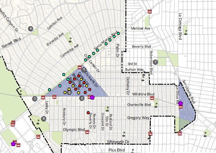
13 Potential Pedestrian Improvements Scramble Crosswalk Rodeo Drive/Dayton Way Raised Crosswalk Beverly Gardens Park 13
14 Pedestrian Crosswalk Policy 14
15 Pedestrian Emphasis Streets
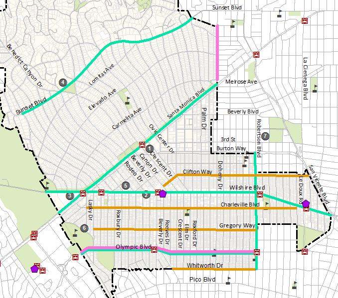
16 Concept improvements for consideration Potential Bike Improvements 16

17 Bike Emphasis Improvements High visibility bike lanes

18 Bike Emphasis Improvements High visibility bike box

19 Bike Emphasis Improvements Protected Bike Lane

20 Bike Emphasis Improvements Bike Boulevard

21 Bike Emphasis Improvements More bike share key connections with transit


22 Bike Emphasis Improvements Reverse Angle Parking 22

23 Bike Emphasis Streets
24 Concept improvements for consideration Potential Transit Improvements 24

25 Transit Emphasis Improvements Transit user amenities: shelters, benches Street operations dedicated to reliable transit travel times Improved signage and/or communications of stops and destinations in proximity to stops Safer connections for peds & bikes 25 Source: MyFigueroa

26 Microtransit Low speed electric autonomous shuttle 26

27 Transit Emphasis Streets 27

28 Concept improvements for consideration Potential Vehicle & Technology Improvements 28

29 Vehicle/Technology Emphasis Improvements Reduce cut-through traffic on non-arterials Traffic calming elements Neighborhood Traffic Circles Curb extensions Speed humps or bumps Turn restrictions 29 Improve major arterials Left-turn restrictions Improve striping and signage visibility Adaptive signal coordination Traffic Circle at Laurel Avenue/Norton Avenue City of West Hollywood


30 Local Street Traffic Calming Emphasis Reduce Speeds to reduce cutthrough traffic from arterials Traffic Calming Measures - Neighborhood Traffic Circle 30


31 Whitworth Drive would have 6 traffic circles 31

32 Concept Technology 5G/DSRC Street furniture + physical infrastructure enhanced 32


33 Concept Technology Digitize the street with Shared Use Mobility Zones 33

34 Concept Technology Smart Street Lights 34
35 Vehicle/Technology Emphasis Streets


36 Timeline + Involvement Opportunities Walk Audit June 9 th RSVP at Workshop #3: Draft Plan Community Feedback August 22 nd Fall 2018 Final Plan to Council 36
37 Group Working Session 1) Review + add to draft complete streets maps minutes Pedestrian Network (15 minutes) Bike Network (15 minutes) Vehicle/Technology Streets (15 minutes) 2) Report back to group - 30 minutes most important thing your group discussed on each network map (pedestrian, bike, vehicle/technology) 37
38 THANK YOU!
Safe Streets. City of Lake Forest Park. March 21, 2017
 Safe Streets City of Lake Forest Park March 21, 2017 1 01 WELCOME 2 Agenda WELCOME WHAT IS THIS PROJECT? CONTEXT DRAFT CITYWIDE PROJECTS EXERCISE INTRODUCTION 3 02 WHAT IS THIS PROJECT? 4 WHAT IS THIS
Tonight is for you. Learn everything you can. Share all your ideas.
 Strathcona Neighbourhood Renewal Draft Concept Design Tonight is for you. Learn everything you can. Share all your ideas. What is Neighbourhood Renewal? Creating a design with you for your neighbourhood.
MASTER BICYCLE AND PEDESTRIAN PLAN
 VILLAGE OF NORTHBROOK MASTER BICYCLE AND PEDESTRIAN PLAN DRAFT PLAN OPEN HOUSE May 2, 2018 AGENDA 1. Community Engagement 2. Vision and Goals 3. General Structure of Plan 4. Recommendations Overview 5.
» Draft Recommendations» Discussion» Next Steps. Plan for Walking and Biking
 SAC Meeting Plan #3 for September Walking and 12, Biking 2018 » Draft Recommendations» Discussion» Next Steps Plan for Walking and Biking » Stakeholder and Public Outreach» Background data collection and
KEARNY MESA COMMUNITY PLAN UPDATE
 KEARNY MESA COMMUNITY PLAN UPDATE January 18, 2018 SUBCOMMITTEE MEETING Mobility Concepts and Urban Design Presentation Outline Mobility Concepts: Multimodal Planning Toolbox Presentation and Activities
Omaha s Complete Streets Policy
 Omaha s Complete Streets Policy (Adopted August 2015) VISION To create great places and enhance our quality of life, the City of Omaha will provide safe, accessible streets for all users. Complete Streets
Existing Pedestrian Conditions. PSAC February 8, 2011
 Existing Pedestrian Conditions PSAC February 8, 2011 Contents 1. Project Background & Goals 2. Pedestrian Activity: Where people walk 3. Pedestrian Safety: The conditions people face Project Background
Bicycle and Pedestrian Advisory Committee (BPAC) November 21, 2013
 November 21, 2013") Bicycle and Pedestrian Advisory Committee (BPAC) November 21, 2013 OVERALL LAND USE CONCEPT Overall Broadway Valdez District: 95.5 acres (35.1 acres right-of ways + 60.4 acres developable land) Plan Subareas:
Bicycle and Pedestrian Advisory Committee (BPAC) November 21, 2013 OVERALL LAND USE CONCEPT Overall Broadway Valdez District: 95.5 acres (35.1 acres right-of ways + 60.4 acres developable land) Plan Subareas:
WELCOME. Thank you for joining us at the Second Public Workshop for the Carlsbad Pedestrian Master Plan. We look forward to receiving your feedback.
 City of Carlsbad Pedestrian Master Plan: WELCOME WELCOME Please Sign In Provide Input at Flip Charts Review Boards Presentation of Draft Plan Thank you for joining us at the Second Public Workshop for
General Plan Circulation Element Update Scoping Meeting April 16, 2014 Santa Ana Senior Center, 424 W. 3rd Street, Santa Ana, CA 92701
 General Plan Circulation Element Update Scoping Meeting April 16, 2014 Santa Ana Senior Center, 424 W. 3rd Street, Santa Ana, CA 92701 Meeting Agenda 1. Purpose of Scoping Meeting 2. Project Overview 3.
Ocean Park Boulevard Streetscape Improvement Project Alternatives & Trade Offs
 City Council Study Session January 27, 2009 Ocean Park Boulevard Streetscape Improvement Project Alternatives & Trade Offs Scope of Work Purpose of Tonight s Meeting Review work to date and direct staff
CONNECTING PEOPLE TO PLACES
 CONNECTING PEOPLE TO PLACES 82 EAST BENCH MASTER PLAN 07 Introduction The East Bench transportation system is a collection of slow moving, treelined residential streets and major arteries that are the
MOBILITY WORKSHOP. Joint City Council and Transportation Commission May 5, 2014
 MOBILITY WORKSHOP Joint City Council and Transportation Commission May 5, 2014 Review of General Plan M-1 Develop world-class transit system M-3 Maintain/enhance pedestrian-oriented City M-4 Create comprehensive
Advancing Transportation Choices in Des Moines. MPO Environmental Roundtable January 9, 2018
 Advancing Transportation Choices in Des Moines MPO Environmental Roundtable January 9, 2018 Presented by Jennifer McCoy, PE, PTOE City Traffic Engineer Agenda Des Moines Area Transportation Planning Connect
STONY PLAIN ROAD STREETSCAPE
 Jasper Place Revitalization Strategy: Vision The people involved in the Jasper Place Revitalization Strategy envision: Goal 1: Feeling safe in our community Create a community where feeling safe is common--where
Complete Streets Chicago: Data Driven Design. Luann Hamilton Deputy Commissioner
 Complete Streets Chicago: Data Driven Design Luann Hamilton Deputy Commissioner AGENDA Chicago s goals Complete Streets & Sustainable Infrastructure Guides Data-Driven Planning Setting goals Scoping/research
The DC Pedestrian Master Plan
 The DC Pedestrian Master Plan September 28, 2010 George Branyan Pedestrian Program Coordinator District Department of Transportation Presentation Agenda Scope of the Plan Methodology Recommendations Implementation
City of Novi Non-Motorized Master Plan 2011 Executive Summary
 City of Novi Non-Motorized Master Plan 2011 Executive Summary Prepared by: February 28, 2011 Why Plan? Encouraging healthy, active lifestyles through pathway and sidewalk connectivity has been a focus
Saskatchewan Drive Roadway Rehabilitation and Shared-Use Path Widening
 Saskatchewan Drive Roadway Rehabilitation and Shared-Use Path Widening We are here today to present the draft plan for the Saskatchewan Drive Roadway Rehabilitation and Shared-Use Path Widening project
Watertown Complete Streets Prioritization Plan. Public Meeting #1 December 14, 2017
 Watertown Complete Streets Prioritization Plan Public Meeting #1 December 14, 2017 Goals for Public Meeting Overview of MassDOT Complete Streets Funding Program Educate the community on Complete Streets
HARRISON STREET/OAKLAND AVENUE COMMUNITY TRANSPORTATION PLAN
 HARRISON STREET/OAKLAND AVENUE Community Workshop #4: Draft Plan Review December 3, 2009 D E S I G N, C O M M U N I T Y & E N V I R O N M E N T INTRODUCTIONS Key Project Staff: Alisa Shen, Project Manager,
Agenda. Overview PRINCE GEORGE S PLAZA METRO AREA PEDESTRIAN PLAN
 PRINCE GEORGE S PLAZA METRO AREA PEDESTRIAN PLAN May 28, 2008 Agenda Welcome and introductions Project overview and issue identification Planning context and strengths Design challenges and initial recommendations
Ocean Park Boulevard Green Street Project Alternatives & Trade Offs
 Planning Commission March 4, 2009 Ocean Park Boulevard Green Street Project Alternatives & Trade Offs Purpose of Tonight s Meeting Review concept plans and options Provide input on alternatives and trade-offs
STEERING COMMITTEE MEETING June 17, Streetscape Overview Burlington Comprehensive Master Plan
 STEERING COMMITTEE MEETING June 17, 2015 Streetscape Overview Burlington Comprehensive Master Plan 1 Introduction Slide This slide show was presented to the Burlington Steering Committee on June 17, 2015
CHAPTER 3: Vision Statement and Goals
 Davidson Walks & Rolls: Active Transportation Master Plan CHAPTER 3 Contents: Overview Vision Statement Measurable Goals Public Outreach CHAPTER 3: Vision Statement and Goals Overview The vision statement
Complete Streets: Planning, Policy & Performance
 Complete Streets: Planning, Policy & Performance Tell Us About Your CS Experiences Successes Hardships Funding Politics Safety Not every street needs to be complete, but every mode needs a complete network.
FOCUS AREA 1 - Alberta Avenue Pocket Park 3 (121 Ave and 92 St)
") FOCUS AREA 1 - Alberta Avenue Pocket Park 3 (121 Ave and 92 St) New benches Plant evergreen trees Widen existing sidewalk from 1.5m to 1.8m Marked crosswalk 1.8m wide sidewalk Add pedestrian oriented lights
FOCUS AREA 1 - Alberta Avenue Pocket Park 3 (121 Ave and 92 St) New benches Plant evergreen trees Widen existing sidewalk from 1.5m to 1.8m Marked crosswalk 1.8m wide sidewalk Add pedestrian oriented lights
Wood and Cortland Neighborhood Greenways
 Wednesday, May 25 th, 2016 Wood and Cortland Neighborhood Greenways Alderman Hopkins 2 nd Ward Alderman Waguespack 32 nd Ward Mike Amsden, AICP Assistant Director of Transportation Planning David Smith,
Commerce Street Complete Street Project from Good Latimer Expressway to Exposition Avenue
 Commerce Street Complete Street Project from Good Latimer Expressway to Exposition Avenue T A N Y A B R O O K S A S S I S T A N T D I R E C T O R M O B I L I T Y P L A N N I N G M O B I L I T Y A N D S
Draft MOBILITY ELEMENET. Community Meeting May 22, 2013
 Draft MOBILITY ELEMENET Community Meeting May 22, 2013 Agenda Presentation Ira Brown New Mobility Paradigm Movement of People Implementation Q&A Ira Brown and Dave Roseman Small Group Discussion at Each
SAFE ROUTES TO SCHOOL (SR2S)
") SAFE ROUTES TO SCHOOL (SR2S) In partnership with Burbank Unified School District (BUSD) & City of Burbank George Washington Elementary School Thomas Jefferson Elementary School John Muir Middle School
SAFE ROUTES TO SCHOOL (SR2S) In partnership with Burbank Unified School District (BUSD) & City of Burbank George Washington Elementary School Thomas Jefferson Elementary School John Muir Middle School
Major Bike Routes 102 Avenue Workshop April 21, 2015
 Major Bike Routes 102 Avenue Workshop April 21, 2015 Our Purpose Today Provide context on how Major Bike Routes fit into Edmonton s future Share information on what we heard in our last phase, and how
EXECUTIVE SUMMARY. Vision
 Vision Walking and bicycling in Salt Lake City will be safe, convenient, comfortable, and viable transportation options that connect people to places, foster recreational and economic development opportunities,
Prince George s County plans, policies, and projects
 Prince George s County plans, policies, and projects Over 250 projects for trails, bikeways, designated bike lanes and sidewalk construction Trail projects that improve access to Metro Sidewalk and trail
Design Guidelines. Overview. Design Vision for Yellow Brick Road
 Design Guidelines Overview This section presents the design vision for the Yellow Brick Road network. The Yellow Brick Road is envisioned to be an interconnected network of safe and secure roadways where
Ocean Park Boulevard Green Street Project Community Workshop
 Ocean Park Boulevard Green Street Project Community Workshop 2.2.10 Project Objectives Community Priority: reclaim OPB for public open space. Build upon LUCE principles; neighborhood enhancement, connectivity,
Why invest in the 1 Street S.W. Corridor?
 Why invest in the 1 Street S.W. Corridor? This project is an investment in the Beltline Community and Calgary s economy. It is anticipated that The City s investment along this corridor will help with
Technical Working Group November 15, 2017
 Technical Working Group November 15, 2017 Welcome and Introductions Project Partners Regional Transportation District (RTD) Colorado Department of Transportation (CDOT) Denver Regional Council of Governments
Table #6 VISION CHARACTERISTICS
 Table #6 VISION White Flint is a place to live, work, play, shop, and walk with sufficient density to encourage quality redevelopment. Vibrant streets and consistent streetscapes are important. CHARACTERISTICS
TRAFFIC ACTION PLAN. North Central Neighborhood CITY OF SAN MATEO
 TRAFFIC ACTION PLAN North Central Neighborhood CITY OF SAN MATEO Draft February 2017 Table of Contents Introduction... 1 The Traffic Forum Process... 4 Neighborhood Traffic Issues... 6 Neighborhood Recommendations
Welcome! Public Open House on UBC s Transportation Plan
 1 Welcome! Public Open House on UBC s Transportation Plan Public open house hours: to When it comes to on-campus transportation, what do you think is working well and what are some opportunities for improvement?
Project Kickoff Meeting February 15, 2018
 Project Kickoff Meeting February 15, 2018 Scope of Work: Study Area Project Goals Develop traffic calming alternatives to the Vine Street local right of way, to mitigate speeding. Develop concept plans
In station areas, new pedestrian links can increase network connectivity and provide direct access to stations.
 The Last Mile Planning for Pedestrians Planning around stations will put pedestrians first. Making walking to stations safe and easy is important; walking will be a part of every rapid transit Accessible
Chapter 3: Multi-Modal Circulation and Streetscapes
 CHAPTER 3: MULTI-MODAL CIRCULATION AND STREETSCAPES Chapter 3: Multi-Modal Circulation and Streetscapes Overview Streetscape improvements have already been completed for Depot Street between Main Avenue
Market/Octavia - Transportation Projects Update
 Market/Octavia - Transportation Projects Update Market/Octavia Community Advisory Committee Feb 9, 2015 Tonight s Goals Update CAC on pending/active projects Respond to Nov 2014 CAC resolution Obtain support
Downtown Naples Mobility and Connectivity Study. Naples City Council Presentation January 2017
 Downtown Naples Mobility and Connectivity Study Naples City Council Presentation January 2017 Agenda 1. Introduction 2. Scope Review 3. Project Schedule 4. Existing Conditions 5. Public Charrette 6. Mobility
Working Group Meeting
 Working Group Meeting February 6, 2018 Parks and Natural Resources Operations Building Transportation Analysis Draft Policy Framework Agenda 7:05 pm Welcome 7:10 pm Follow-up from Previous Meetings Schedule
PRINCE GEORGE S PLAZA METRO AREA PEDESTRIAN PLAN
 PRINCE GEORGE S PLAZA METRO AREA PEDESTRIAN PLAN May 28, 2008 Agenda Welcome and introductions Project overview and issue identification Planning context and strengths Design challenges and initial recommendations
A CHANGING CITY. of Edmonton, it is essential that it reflects the long-term vision of the City.
 A CHANGING CITY By the year 2040, Edmonton will be home to more than 1 million people. To accommodate growth and support a healthy and compact city, we need a new approach to development/redevelopment
CLOSED. Highlights of the Final Concept Design:
 The final Concept Design is the result of many months of listening, learning, creating, balancing, and understanding different needs and viewpoints, as well as incorporating technical requirements and
BALBOA AREA: TRANSPORTATION PROJECTS & PLANNING
 BALBOA AREA: TRANSPORTATION PROJECTS & PLANNING TRANSPORTATION FOR ALL AGES, ABILITIES & MEANS CHANGING PATTERNS: TRENDING TO WALKING, BIKING, TRANSIT San Francisco s Change in Number of Commuters by Mode
Central Freeway and Octavia Circulation Study
 Central Freeway and Octavia Circulation Study Final Report Plans and Programs Committee San Francisco County Transportation Authority September 18, 2012 Presentation Outline Background and Study Purpose
Item to be Addressed Checklist Consideration YES NO N/A Required Description Complete Streets Guidelines
 Passaic County Complete Streets Checklist - Concept Development Project Name Item to be Addressed Checklist Consideration YES NO N/A Required Description Complete Streets Guidelines Existing Plans Have
REGIONAL BICYCLE AND PEDESTRIAN DESIGN GUIDELINES
 REGIONAL BICYCLE AND PEDESTRIAN DESIGN GUIDELINES November 16, 2011 Deb Humphreys North Central Texas Council of Governments Bicycle and Pedestrian Advisory Committee Snapshot of the Guide 1. Introduction
forwarddallas! Implementation Proposed Chapter 43 Code Amendment On-Street Parking
 forwarddallas! Implementation Proposed Chapter 43 Code Amendment On-Street Parking Transportation and Environment Committee Briefing December 10, 2007 PURPOSE Code amendment to establish regulations consistent
Lincoln Neighborhood Corridor Plan The LiNC
 CITY OF SANTA MONICA Lincoln Neighborhood Corridor Plan The LiNC PLANNING COMMISSION September 2, 2015 COMMUNITY DESIGN + ARCHITECTURE TEAM: Community Design + Architecture Iteris Studio 111 Urban Place
CONTEXT SENSITIVE STREETS STANDARDS COMMITTEE
 CONTEXT SENSITIVE STREETS STANDARDS COMMITTEE February 23, 2015 Prepared by: Denise Chaplick, AICP City Jacksonville Bicycle and Pedestrian Coordinator Source: NCDOT Complete Streets Planning and Design
2014/2015 BIKE ROUTE PLAN 83 AVENUE PROTECTED BIKE LANE
 About the Project 2014/2015 BIKE ROUTE PLAN The City of Edmonton is planning a major bike route on the south side of Edmonton. This bike route is one part of a plan to provide citizens with transportation
SR 693 (Pasadena Avenue) Corridor Study from Shore Drive South to 66 th Street
 Corridor Study from Shore Drive South to 66 th Street") Welcome and Introduction Sign-in and comment sheets Restrooms and exits Meeting agenda and timeline Meeting goals / expectations Provide input to guide study recommendations Actively participate throughout
Welcome and Introduction Sign-in and comment sheets Restrooms and exits Meeting agenda and timeline Meeting goals / expectations Provide input to guide study recommendations Actively participate throughout
Speed Limits Study and Proposal. Public Input Session: 8/14/13
 Speed Limits Study and Proposal Public Input Session: 8/14/13 Why is Decatur a unique place for this project? First Community Transportation Plan in the nation with a Health Impact Assessment. Strong sense
Stakeholder Update. Agenda. Project update Needs Identification Strategy Proposed needs Safety Collectors/Arterials Greenways Local roads
 1 Stakeholder Update May 21, 2018 2 Agenda Project update Needs Identification Strategy Proposed needs Safety Collectors/Arterials Greenways Local roads Proposed Evaluation Criteria Next Steps 1 Project/Schedule
NEWMARKET UPHAM S CORNER
 SOUTH STATION Planning Initiative NEWMARKET UPHAM S CORNER COLUMBIA ROAD (P) FOUR CORNERS/GENEVA Working Advisory Group (WAG) Meeting #5 TALBOT AVENUE MORTON STREET BLUE HILL AVE/CUMMINS HWY (P) RIVER
Telegraph Avenue Complete Streets DRAFT Recommendations. Oakland Public Works Department September 11 and 13, 2014 Open Houses
 Telegraph Avenue Complete Streets DRAFT Recommendations Oakland Public Works Department September 11 and 13, 2014 Open Houses Presentation Overview What are complete streets? What problem are we trying
122 Avenue: 107 Street to Fort Road
 : 107 Street to Fort Road November 24, 2015 4:30 8:00 p.m. Meeting Purpose Summarize project work completed to date Share results of public input from Phase 1 Share the draft concept plan and proposed
TRAFFIC ACTION PLAN. Laurie Meadows Neighborhood CITY OF SAN MATEO
 TRAFFIC ACTION PLAN Laurie Meadows Neighborhood CITY OF SAN MATEO Draft January 2017 Table of Contents Introduction... 2 The Traffic Forum Process... 5 Neighborhood Traffic Issues... 7 Neighborhood Recommendations
Transportation Assessment
 Transportation Assessment Midtown Open House February 10, 2018 Overview Midtown in Focus Overview & Purpose of Today Transportation Assessment overview Summary of Transportation work to date Review & Analysis
Pedestrian Project List and Prioritization
 To: Kyle Wagenschutz, City of Memphis CC: From: Anne Conlon and John Cock, Alta Planning + Design Date: December, 2014 Re: Project List Development (Task 3.1-3.2) and Project List Prioritization (Task
2014/2015 BIKE ROUTE PLAN 83 AVENUE PROTECTED BIKE LANE
 About the Project The City of Edmonton is planning a major bike route on the southside of Edmonton. The Strathcona Bike Route will connect the communities of Strathcona, Garneau and the University area,
9/25/2018. Multi-Modal Level of Service (MMLOS) Bianca Popescu, Transportation Planner
 Bianca Popescu, Transportation Planner") Multi-Modal Level of Service (MMLOS) Bianca Popescu, Transportation Planner 1 What is MMLOS? Is this a nice place to walk? Is this a nice place to bike? Is transit convenient? Bottom line - Are there options
Multi-Modal Level of Service (MMLOS) Bianca Popescu, Transportation Planner 1 What is MMLOS? Is this a nice place to walk? Is this a nice place to bike? Is transit convenient? Bottom line - Are there options
IBI Group November 5, 2012
 IBI Group Agenda Session 1 3:00 PM Welcome / Sign in 3:10 PM Presentation 3:30 PM Questions? 3:35 PM World Café Discussion 4:45 PM Report on top 3 ideas 4:50 PM Next Steps 5:00 PM Adjourn 2 Agenda Session
NJDOT Complete Streets Checklist
 Background The New Jersey Department of Transportation s Complete Streets Policy promotes a comprehensive, integrated, connected multi-modal network by providing connections to bicycling and walking trip
City of Birmingham Draft Multi-modal Transportation Plan
 City of Birmingham Draft Multi-modal Transportation Plan City Commission Public Hearing Monday, November 25, 2013 7:30 pm Norman Cox, PLA, ASLA The Greenway Collaborative, Inc. Ann Arbor, Michigan The
Getting Your SRTS Project Funded. Ryan Snyder
 Getting Your SRTS Project Funded Ryan Snyder Steps in Submitting a Successful Application 1. Stakeholder outreach: create a SRTS coalition 2. Develop a comprehensive plan and program with all 5 Es 3. Conceive
Table of Contents Introduction. 2 Purpose of the Plan...2 The Benefits of Walking and Bicycling...3 Vision and Goals of the Plan...
 BICYCLE AND This plan was created through a grant from the Healthy Communities Program with the cooperation of the City of Cynthiana, Cynthiana Main Street, Cynthiana-Harrison County-Berry Joint Planning
Plant City Walk-Bike Plan
 Plant City Walk-Bike Plan Plant City Commute Mode Share 2.2% 1.4% 2.9% Drove alone 10.2% Carpooled Public transportation (0.1%) Walked Used a Bike (0.4%) 82.9% Taxicab, motorcycle, or other means Worked
Chapter 14 PARLIER RELATIONSHIP TO CITY PLANS AND POLICIES. Recommendations to Improve Pedestrian Safety in the City of Parlier (2014)
") Chapter 14 PARLIER This chapter describes the current status and future plans for biking and walking in the City of Parlier. RELATIONSHIP TO CITY PLANS AND POLICIES The Parlier General Plan is the primary
Chapter 14 PARLIER This chapter describes the current status and future plans for biking and walking in the City of Parlier. RELATIONSHIP TO CITY PLANS AND POLICIES The Parlier General Plan is the primary
Mayor s Bicycle Advisory Council. Wednesday, December 13 th, 2017
 Mayor s Bicycle Advisory Council Wednesday, December 13 th, 2017 Bicyclist Fatalities, Year to Date (January 1 November 30, 2017) - MBAC Briefing Bicyclist Fatality Statistics Year to date total, 2017
Hennepin Avenue Reconstruction Washington Avenue to 12 th Street
 CITY OF MINNEAPOLIS Hennepin Avenue Reconstruction Washington Avenue to 12 th Street April 2016 1 Upcoming Opportunities Public Meeting #2 April 25, 2016 Minneapolis Central Library Doty Board Room Repeat
Dewey Area Traffic Calming Project
 SFMTA Municipal Transportation Agency Image: Crosswalk of California Street and Grant Avenue Dewey Area Traffic Calming Project 10 08 2013 SAN FRANCISCO, CALIFORNIA Tonight s Agenda Introductions Project
Pedestrian, Bicycle and Traffic Calming Strategic Implementation Plan. January 18, 2011
 Pedestrian, Bicycle and Traffic Calming Strategic Implementation Plan January 18, 2011 Tonight s Agenda Receive update on project Provide feedback on two policy issues Complete Streets Policy Project Prioritization
Community Task Force November 15, 2017
 Community Task Force November 15, 2017 Welcome and Introductions Project Partners Regional Transportation District (RTD) Colorado Department of Transportation (CDOT) Denver Regional Council of Governments
Santa Ana Creating Community Together
 City of Santa Ana Creating Community Together Circulation & Housing Element Update Open House Thursday, May 9, 2013 1 General Plan Circulation Element Update Open House #3 2 What is a Circulation Element?
University of Victoria Campus Cycling Plan Terms of Reference. 1.0 Project Description
 University of Victoria Campus Cycling Plan Terms of Reference 1.0 Project Description The Campus Cycling Plan, a first for the University, will provide a comprehensive and coordinated approach to support
APPENDIX A: Complete Streets Checklist DRAFT NOVEMBER 2016
 APPENDIX A: Complete Streets Checklist DRAFT NOVEMBER 2016 Complete Streets Checklist MetroPlan Orlando s Complete Streets Checklist is an internal planning tool for staff to further implementation of
PEDESTRIAN ACTION PLAN
 ATTACHMENT 2 CITY OF SANTA MONICA PEDESTRIAN ACTION PLAN CITY OF SANTA MONICA PEDESTRIAN ACTION PLAN This page intentionally left blank EXECUTIVE SUMMARY CHAPTER 1 EXECUTIVE SUMMARY Setting the Stage
This page intentionally left blank.
 This page intentionally left blank. COMMUNITY Coweta Community Overview Coweta Coweta, a residential community located in Wagoner County, is a suburb of Tulsa situated southeast of the metropolitan area
WELCOME! Please complete a comment sheet as we value your feedback. 4 pm to 8 pm. September 15, Hosted by: AECOM on behalf of City of Calgary
 WELCOME! Thank you for attending our open house. There will be no formal presentation today so please take the time to read the boards. If you have any questions, please do not hesitate to approach one
Complete Streets for Niagara A working method to visualize the creation of a complete street June 20th, 2013
 Complete Streets for Niagara A working method to visualize the creation of a complete street June 20th, 2013 C O N T E N T S Introduction and background of the report What is a complete street? What can
CITY OF MINNEAPOLIS 26 th St E/W & 28 th St E/W Protected Bikeway. Open House - February 2017
 CITY OF MINNEAPOLIS 26 th St E/W & 28 th St E/W Protected Bikeway Open House - February 2017 2/27/2017 1 Purpose of Meeting Inform: Provide an overview of the project Opportunity to gather feedback/input/observations
Street Design Workshop. Existing cross section Traffic volumes Examine adjacent land uses You design future improvements
 Street Design Workshop Existing cross section Traffic volumes Examine adjacent land uses You design future improvements Primary Tools for Street Redesign Road diets Bike lanes Cycle tracks Trails Crosswalks
95 th Street Corridor Transportation Plan. Steering Committee Meeting #2
 95 th Street Corridor Transportation Plan Steering Committee Meeting #2 February 18, 2015 PURPOSE OF THE MEETING Update Steering Committee Present Community/Stakeholder Survey Results Present Transportation
MEETING OF THE CITY OF CONCORD BICYCLE, PEDESTRIAN AND SAFE ROUTES TO TRANSIT PLAN ADVISORY COMMITTEE AGENDA
 MEETING OF THE CITY OF CONCORD BICYCLE, PEDESTRIAN AND SAFE ROUTES TO TRANSIT PLAN ADVISORY COMMITTEE Monday, April 25, 2016 5:30 p.m., Regular Meeting PERMIT CENTER CONFERENCE ROOM 1950 Parkside Drive,
Safe Routes to School: Munroe Elementary Walk Audit Report. Image: Drexel, Barrell & Co.
 Safe Routes to School: Munroe Elementary Walk Audit Report Image: Drexel, Barrell & Co. April 12, 2016 OVERVIEW As part of the 2014/2015 Denver Safe Routes to School (SRTS) Program, WalkDenver coordinated
Appendix C 3. Bicycle / Pedestrian Planning
 Appendix C 3. Bicycle / Pedestrian Planning BICYCLE/PEDESTRIAN PLANNING 2005 Master Plan GOAL: Provide for safe and convenient bicycle and pedestrian circulation throughout the City. Develop a city-wide
Merrick and Memorial Neighborhood Study 5/14/2014 Public Meeting
 Merrick and Memorial Neighborhood Study 5/14/2014 Public Meeting Study Area April 9 Public Meeting Comments Summary Pedestrian Safety - A Walking Neighborhood Pedestrian traffic is very difficult A need
5. Pedestrian System. Accomplishments Over the Past Five Years
 5. Pedestrian System Accomplishments Over the Past Five Years The Alamo Area Metropolitan Planning Organization (MPO) and its partner agencies recognize the importance of improving pedestrian mobility.
CLOSED. The draft concept design has been broken down into 5 categories for the purpose of this survey:
 Old Strathcona s neighbourhood renewal process is now at the draft concept design phase. Over the last several months, the city has been gathering local knowledge and resident input that has been used
PROJECT OVERVIEW. 20th Avenue Project Limits (Lincoln Way to Wawona St)
") PROJECT OVERVIEW In 2014, San Francisco adopted Vision Zero as City policy, with a commitment to eliminate all traffic deaths in the City by 2024. nue Project Limits (Lincoln Way to St) Collision data
PROJECT OVERVIEW In 2014, San Francisco adopted Vision Zero as City policy, with a commitment to eliminate all traffic deaths in the City by 2024. nue Project Limits (Lincoln Way to St) Collision data
City of Jacksonville Mobility Fee Update
 City of Jacksonville Mobility Fee Update 2017 Preliminary Analysis May 3, 2017 Carnival Cruise lines photo credit Presentation Overview Public Outreach Process Pedestrian and Bicycle Master Plan Study
Arlington s Master Transportation Plan
 Arlington s Master Transportation Plan The Master Transportation Plan (MTP) Adopted in eight parts Goals & Policies element and MTP Map adopted in 2007 Bicycle, Pedestrian and Demand and Systems Management