CONTEXT SENSITIVE STREETS STANDARDS COMMITTEE
|
|
|
- Arron Allison
- 5 years ago
- Views:
Transcription


1 CONTEXT SENSITIVE STREETS STANDARDS COMMITTEE February 23, 2015 Prepared by: Denise Chaplick, AICP City Jacksonville Bicycle and Pedestrian Coordinator
2


3 Source: NCDOT Complete Streets Planning and Design Guidelines


4 Threshold Matrix Typical Cross-Section Matrix Source: NCDOT Complete Streets Planning and Design Guidelines

5 Source: NCDOT Complete Streets Planning and Design Guidelines

6
7 Typical Cross-Section CS Street Types Residential Main/Commercial Vehicle Transit
8 CS Street Types (All Users) 1. Street 2. Avenue 3. Boulevard 4. Thoroughfare
9 LAND USE CBD STREET TYPE SPECIAL Residential Main/Commercial Vehicle Transit TYPICAL CROSS-SECTION MATRIX STREET AVENUE BOULEVARD THOROUGHFARE Local Collector Arterial All Road Classes 35mph and Above Neighborhood (Yield Street, High Density/Multi-Family, Boulevard) Urban Main Street Urban Avenue (3-lanes) Urban Boulevard (4-lanes) Urban Road Urban Avenue (3-lanes) Urban Boulevard (4-lanes) Urban Thoroughfare Urban Transit Road Urban Transit Avenue Urban Transit Boulevard Urban Transit Thoroughfare LAND USE URBAN STREET TYPE SPECIAL Residential Main/Commercial Vehicle Transit STREET AVENUE BOULEVARD THOROUGHFARE Local Collector Arterial All Road Classes 35mph and Above Neighborhood (Yield Street, High Density/Multi-Family, Boulevard) Urban Main Street Urban Avenue (3-lanes) Urban Boulevard (4-lanes) Urban Road Urban Avenue (3-lanes) Urban Boulevard (4-lanes) Urban Thoroughfare Urban Transit Road Urban Transit Avenue Urban Transit Boulevard Urban Transit Thoroughfare LAND USE SUBURBAN STREET TYPE SPECIAL Residential Main/Commercial Vehicle Transit STREET AVENUE BOULEVARD THOROUGHFARE Local Collector Arterial All Road Classes 35mph and Above Neighborhood (Yield Street, High Density/Multi-Family, Boulevard) Suburban Main Street/Commercial Suburban Avenue (3-lanes) Suburban Boulevard (4-lanes) Suburban Road Suburban Avenue (2-lanes) Suburban Boulevard (4-lanes) Suburban Thoroughfare Urban Transit Road Urban Transit Avenue Urban Transit Boulevard Urban Transit Thoroughfare LAND USE RURAL STREET TYPE SPECIAL Residential Main/Commercial Vehicle Transit STREET AVENUE BOULEVARD THOROUGHFARE Local Collector Arterial All Road Classes 35mph and Above Neighborhood (Yield Street, High Density/Multi-Family, Boulevard) Rural Main Street Rural Road Rural Avenue Rural Avenue (3-lanes) Rural Thoroughfare Urban Transit Road Urban Transit Avenue Urban Transit Boulevard Urban Transit Thoroughfare
10 Residential 1. Yield 2. Low Density 3. Medium Density 4. High Density/Mixed Use 5. Boulevard Designed to carry low speeds and low volumes of vehicular traffic On-street parking varies and is generally dictated by level of density and need Density level is determined by lot size, total number of units, and length of block Pedestrian activity is expected, encouraged, and accommodated Bike lanes are typically not necessary due to low speed/volume, but are allowed
 conflicting movements Yield Streets have off-street parking provisions and a high demand for on-street parking (40 60% utilization or less).")
.")
11 Residential Yield Street Yield Streets are 2-way and operate best where drivers are expected to travel at low speeds, allowing opposing traffic time and space necessary to negotiate (yield) conflicting movements Yield Streets have off-street parking provisions and a high demand for on-street parking (40 60% utilization or less). Yield Streets are can be found in historic neighborhoods with narrow streets, high density mix use neighborhoods. Yield Street parking on both sides functions most effectively at feet (10-12 travel way and 7-8 parking). Yield streets parking on only one side can be as narrow as 16 feet, assuming that parking utilization is low enough for cars to safely yield and pass one another.
.")
12 Residential Yield Street Yield Street parking on both sides functions most effectively at feet (10-12 travel way and 7-8 parking)

13 Residential Low Density Low density residential streets are two-way streets and operate best under low speeds and low volumes. On-street parking is typically not required due to low demand, but is allowed. Low density streets are typically found in both rural and suburban areas. Pedestrian activity is expected, encouraged, and to be accommodated. Low density is determined by number of lots/units per acre (i.e. single family homes on large lots, with four or fewer units per acre).

14 Residential Low Density Low density streets function most effectively at feet (10-11 travel lanes). On-street parking can be accommodated at feet, given the low demand and traffic volumes

15 Residential Medium Density Medium density residential streets are twoway streets and operate best under low speeds and low volumes. On-street parking is allowed, unless demand is expected to be low, then parking on one-side should be considered. Medium density streets are typically found in both rural and suburban areas. Pedestrian activity is expected, encouraged, and to be accommodated. Medium density is determined by number of lots/units per acre.
 On-street")

16 Residential Medium Density Medium density streets function most effectively at feet (10-11 travel lanes) On-street parking can be accommodated via yielding, or on one or both sides of street, depending on the demand

17 Residential High Density/Mixed Use High density residential streets are compatible and sometimes integrated and with mixed uses. High density residential streets operate best under low speeds and low volumes, and often include traffic calming elements to moderate speed. High density streets are found in both urban and suburban areas.


18 CONTEXT SENSITIVE STREETS Residential High Density/Mixed Use On-street parking is typical on both sides, to accommodate high demand. Travel lanes to accommodate occasional local transit or freight vehicles. Bike lanes should be considered as traffic volumes increase. Pedestrian activity is expected, encouraged, and to be accommodated


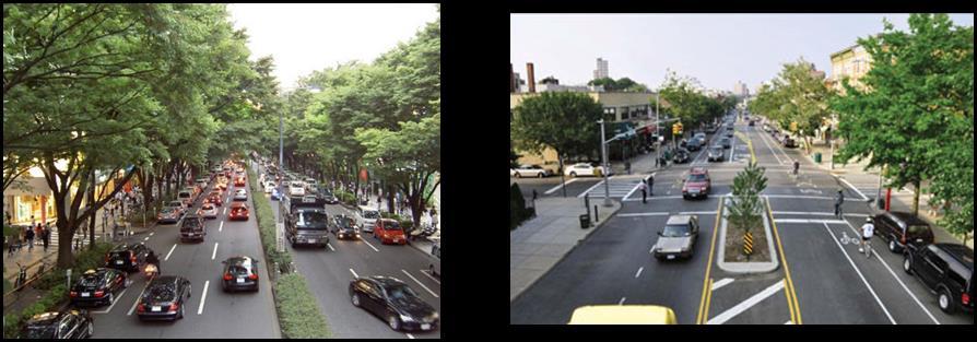
19 Boulevard Boulevards often function as high-speed thoroughfares, even though their adjacent land uses is primarily residential. Existing Boulevards typically have excess width, underutilized on-street parking, and too many travel lanes. Boulevards operate best under low to moderate speeds and often include traffic calming elements to moderate speed. Boulevards are found in both urban and suburban areas.


20 Boulevard Boulevards typically include curbside parking, dedicated bike lanes, curb extensions to provide direct access from homes to the center median. All of which serve to narrow the travel way and reinforce residential character and moderate speeds. Travel lanes to accommodate occasional local transit or freight vehicles


21 Typical Cross-Section CS Street Types Residential Main/Commercial Vehicle Transit
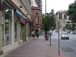
22 Main Street/Commercial 1. Rural Main Street 2. Suburban Main Street/ Commercial 3. Urban Main Street Serves as center of civic, social, and commercial activity in all area types Design emphasis is focused on accommodating high volume of pedestrians Designed to carry low vehicle speeds and integrate bike and transit access Characterized by wide sidewalks, crossing treatments, and pedestrian oriented amenities Bike lanes are typically not necessary due to lower speed/volume street, but are as volumes and speeds increase
23
24 THOROUGHFARE A thoroughfare is a functional classification of roadway (arterial, collector, or local) that has a posted speed limit above 35mph. Thoroughfares typically serve moderate to high volumes of traffic and travel speeds and are typically primary transit and truck routes. Thoroughfare s support transit and non-motorized travel by providing both sidewalks and bicycle lanes. Thoroughfares generally serve both regional and local trips through a city. BOULEVARD - A boulevard is an arterial street with a posted speed limit of 35mph and under. Boulevards typically serve high volumes of traffic and moderate travel speeds and are typically transit and truck routes. Boulevards are intended to be walkable with a compatible speed limit (35mph and under) and encourage transit and non-motorized travel by providing pedestrian and bicycle facilities (i.e. sidewalks and bicycle lanes). Boulevards generally serve longer trips between major activity centers connecting destinations such as urban, employment, and housing. AVENUE An avenue is a collector street with a posted speed limit of 35mph and under. Avenues serve high volumes of traffic with low to moderate travel speeds. Avenues are intended to be walkable with a compatible speed limit (35mph and under) and encourage transit and non-motorized travel by providing pedestrian and bicycle facilities (i.e. sidewalks and bicycle lanes). Avenues serve short distance connections between activity centers. STREET A street is a local street with a posted speed limit of 35mph and under. Streets serve low to moderate volumes of traffic with low travel speeds. In general streets are intended to be walkable and support a mix of travel modes. Ideally, the posted speed should not exceed 25mph to accommodate the mixed modes. Streets serve short local trips and provide direct access to abutting properties.
and Rural Multimodal Networks 2017 ALTA PLANNING + DESIGN
 Small Town and Rural Multimodal Networks 2017 ALTA PLANNING + DESIGN SMALL TOWN AND RURAL MULTIMODAL NETWORKS GUIDE Why a Rural and Small Town Focused Guide? ONE SIZE DOES NOT FIT ALL. The new FHWA-endorsed
DRAFT - CITY OF MEDFORD TRANSPORTATION SYSTEM PLAN Roadway Cross-Sections
 Roadway Cross-Sections Medford s roadway cross-section standards apply to new and reconstructed roads. The crosssections take into consideration roadway function and operational characteristics, including
Classification Criteria
 SCHEDULE D TO RECOMMENDED OFFICIAL PLAN AMENDMENT NO. 40 SCHEDULE C-4 Road Criteria Criteria Traffic Service Objective Land Service/Access Typical Daily Traffic Volume Flow characteristics Travel Speed
Multimodal Through Corridors and Placemaking Corridors
 68 Multimodal Through Corridors and Placemaking Corridors Corridors have different functions in a region. Some corridors are used to get smoothly and rapidly through a region or to get quickly to major
Report. Typical Sections. City of Middleton, WI
 Report Typical Sections City of Middleton, WI December 2006 Report for City of Middleton, Wisconsin Typical Sections repared by: Traffic Associates LLC and STRAND ASSOCIATES, INC. 910 West Wingra Drive
Downey Road. Transportation Improvement Study
 Downey Road Transportation Improvement Study Workshop 2 Participant Handbook Workshop 1 May 18 and 19, 2016 Workshop 2 June 23 and 28, 2016 Prepared By: City of Guelph Paradigm Transportation Solutions
West Dimond Blvd Upgrade Jodhpur Street to Sand Lake Road
 West Dimond Blvd Jodhpur St to Sand Lake CSS Transportation Project Summary Municipality of Anchorage Project # 05 005 Project Manager: John Smith, P.E. (MOA PM&E) Project Administrator: Julie Makela,
Brian D. Hare, P.E. Bureau of Design PennDOT PA APA Annual Conference Investing in a Sustainable Future October 5, 2009
 Brian D. Hare, P.E. Bureau of Design PennDOT 2009 PA APA Annual Conference Investing in a Sustainable Future October 5, 2009 1 What is Smart Transportation? Photographer: heyjude. Used through license
o n - m o t o r i z e d transportation is an overlooked element that can greatly enhance the overall quality of life for the community s residents.
 N o n - m o t o r i z e d transportation is an overlooked element that can greatly enhance the overall quality of life for the community s residents. 84 Transportation CHAPTER 11 INTRODUCTION Transportation
complete streets design and construction standards public primer City of Edmonton
 complete streets design and construction standards public primer City of Edmonton introduction Complete Streets are streets for everyone: people who walk, wheel, bike, take transit, or drive. They are
2.0 LANE WIDTHS GUIDELINE
 2.0 LANE WIDTHS GUIDELINE Road Engineering Design Guidelines Version 2.0.1 May 2018 City of Toronto, Transportation Services City of Toronto Page 0 Background In early 2014, Transportation Services initiated
Recommended Roadway Plan Section 2 - Land Development and Roadway Access
 Recommended Roadway Plan Section 2 - Land Development and Roadway Access SECTION 2 Land Development and Roadway Access 2.1 Land Use and Access Management The Federal Highway Administration (FHWA) defines
5 CIRCULATION AND STREET DESIGN
 5 CIRCULATION AND STREET DESIGN This chapter describes circulation and streetscape improvements proposed for the Northwest Chico Specific Plan Area. It includes detailed design specifications for existing
Complete Streets: Planning, Policy & Performance
 Complete Streets: Planning, Policy & Performance Tell Us About Your CS Experiences Successes Hardships Funding Politics Safety Not every street needs to be complete, but every mode needs a complete network.
Planning Guidance in the 2012 AASHTO Bike Guide
 Planning Guidance in the 2012 AASHTO Bike Guide Presentation by: RJ Eldridge Peter Lagerwey August 22, 2012 WEBINAR 2: PLANNING GUIDANCE IN THE 2012 AASHTO BIKE GUIDE Today s Webinar Significant Updates
SECTION 1 - TRAFFIC PLANNING
 SECTION 1 - TRAFFIC PLANNING 1.1 TRAFFIC OPERATIONS 1.1.1 Roadway Functional Classification The Multnomah County Comprehensive Framework Plan s Policy 34: Trafficways and the Functional Classification
Retrofitting Urban Arterials into Complete Streets
 Retrofitting Urban Arterials into Complete Streets John N. LaPlante, P.E., P.T.O.E., T.Y. Lin International Prepared for: Illinois Traffic Engineering & Safety Conference Urbana, Illinois October 18, 2007
APPENDIX B(2) MULTIMODAL DESIGN STANDARDS FOR MIXED-USE URBAN CENTERS
 MULTIMODAL DESIGN STANDARDS FOR MIXED-USE URBAN CENTERS") APPENDIX B(2) MULTIMODAL DESIGN STANDARDS FOR MIXED-USE URBAN CENTERS SECTION B(2) - 1 INTRODUCTION Introduction... B(2)-1 Fundamental Concepts and Definitions... B(2)-5 SECTION B(2) 2 ROADWAY GEOMETRIC
APPENDIX B(2) MULTIMODAL DESIGN STANDARDS FOR MIXED-USE URBAN CENTERS SECTION B(2) - 1 INTRODUCTION Introduction... B(2)-1 Fundamental Concepts and Definitions... B(2)-5 SECTION B(2) 2 ROADWAY GEOMETRIC
City of Elizabeth City Neighborhood Traffic Calming Policy and Guidelines
 City of Elizabeth City Neighborhood Traffic Calming Policy and Guidelines I. Purpose: The City of Elizabeth City is committed to ensure the overall safety and livability of residential neighborhoods. One
forwarddallas! Implementation Proposed Chapter 43 Code Amendment On-Street Parking
 forwarddallas! Implementation Proposed Chapter 43 Code Amendment On-Street Parking Transportation and Environment Committee Briefing December 10, 2007 PURPOSE Code amendment to establish regulations consistent
Appendix 3 Roadway and Bike/Ped Design Standards
 Appendix 3 Roadway and Bike/Ped Design Standards OTO Transportation Plan 2040 4/20/2017 Page A3-1 Adopted Standards The adopted OTO Design Standards and Major Thoroughfare Plan are contained herein.
County of Greenville South Carolina. Traffic Calming Program Neighborhood Traffic Education Program and Speed Hump Program
 County of Greenville South Carolina Traffic Calming Program Neighborhood Traffic Education Program and Speed Hump Program (rev) August 2008 I. PURPOSE The potential negative impacts from vehicular traffic
On Road Bikeways Part 1: Bicycle Lane Design
 On Road Bikeways Part 1: Bicycle Lane Design Presentation by: Nick Jackson Bill Schultheiss, P.E. September 04, 2012 FOLLOW THE CONVERSATION ON TWITTER Toole Design Group is live tweeting this webinar
CURBSIDE ACTIVITY DESIGN
 5 CURBSIDE ACTIVITY DESIGN This chapter provides design guidance for separated bike lanes adjacent to curbside activities including parking, loading and bus stops. Typical configurations are presented
Arlington s Master Transportation Plan
 Arlington s Master Transportation Plan The Master Transportation Plan (MTP) Adopted in eight parts Goals & Policies element and MTP Map adopted in 2007 Bicycle, Pedestrian and Demand and Systems Management
INTRODUCTION THOROUGHFARE SYSTEM CLASSIFICATIONS
 INTRODUCTION The thoroughfare plan will assist public officials in the development of a specialized system for efficient and safe movement of vehicular traffic while minimizing potential conflicts with
Water Street Promenade Engineering and Design Services
 Preliminary Design Presentation Parking & Traffic Safety Committee Water Street Promenade Engineering and Design Services July 16,2014 November 3, 2016 Education / Infrastructure / Innovation 1 Project
STEERING COMMITTEE MEETING June 17, Streetscape Overview Burlington Comprehensive Master Plan
 STEERING COMMITTEE MEETING June 17, 2015 Streetscape Overview Burlington Comprehensive Master Plan 1 Introduction Slide This slide show was presented to the Burlington Steering Committee on June 17, 2015
Omaha s Complete Streets Policy
 Omaha s Complete Streets Policy (Adopted August 2015) VISION To create great places and enhance our quality of life, the City of Omaha will provide safe, accessible streets for all users. Complete Streets
MOVING PASSAIC COUNTY
 MOVING PASSAIC COUNTY COMPLETE STREETS GUIDELINES OCTOBER 2012 Prepared By: Passaic County Department of Planning and Economic Development with assistance from Parsons Brinckerhoff PASSAIC COUNTY COMPLETE
County of Spartanburg South Carolina
 County of Spartanburg South Carolina Traffic Calming Program June 2012 (Revised/Program on Hold) PURPOSE The potential negative impacts from vehicular traffic on residential roads have been a longstanding
City of Wayzata Comprehensive Plan 2030 Transportation Chapter: Appendix A
 A1. Functional Classification Table A-1 illustrates the Metropolitan Council s detailed criteria established for the functional classification of roadways within the Twin Cities Metropolitan Area. Table
Implementation challenge 2: Is there room for Complete Streets? Does street classification enable Complete Streets?
 Implementation challenge 2: Is there room for Complete Streets? Does street classification enable Complete Streets? 1 Do we have to widen roads to fit everything? 2 There s room; it needs to be recaptured
El Camino Real Specific Plan. TAC/CAC Meeting #2 Aug 1, 2018
 El Camino Real Specific Plan TAC/CAC Meeting #2 Aug 1, 2018 Land Use Alternatives Goals and Tradeoffs Parks & open space Housing Retail & services Civic spaces Parking Community gathering spaces 3 Alternatives
GLOSSARY CROSSWALK. CROSSING TYPES
 CROSSWALK The part of a roadway at an intersection included within the connections of the lateral lines of the sidewalks on opposite sides of the street measured from the curbs, or in the absence of curbs
Ada County Highway District
 Ada County Highway District LIVABLE STREET DESIGN GUIDE ADOPTED D MAY 27, 2009 0 Committed to Service This page is intentionally left blank. TABLE OF CONTENTS 1.0 Basics of the Livable Street Design Guide
THE ALAMEDA CONCEPT DESIGN COMMUNITY MEETING 3. A Plan for The Beautiful Way JANUARY 28, 2010
 CONCEPT DESIGN COMMUNITY MEETING 3 JANUARY 28, 2010 AGENDA INTRODUCTION COMMUNITY INPUT ROADWAY STUDIES STREETSCAPE DESIGN STATIONS DISCUSSION SUMMARY AND DISCUSSION NEXT STEPS CLOSE INTRODUCTION SCHEDULE
Town of Leland Street Design Guidelines
 Town of Leland Street Design Guidelines Prepared for: Town of Leland February 2018 Table of Contents 1 Introduction... 1 2 Street Network Plans and Policies... 3 2.1 Relevant Plans and Policies...3 2.2
Active Transportation Facility Glossary
 Active Transportation Facility Glossary This document defines different active transportation facilities and suggests appropriate corridor types. Click on a facility type to jump to its definition. Bike
REGIONAL BICYCLE AND PEDESTRIAN DESIGN GUIDELINES
 REGIONAL BICYCLE AND PEDESTRIAN DESIGN GUIDELINES November 16, 2011 Deb Humphreys North Central Texas Council of Governments Bicycle and Pedestrian Advisory Committee Snapshot of the Guide 1. Introduction
Circulation in Elk Grove includes: Motor vehicles, including cars and trucks
 Circulation, as it is used in this General Plan, refers to the many ways people and goods move from place to place in Elk Grove and the region. Circulation in Elk Grove includes: Motor vehicles, including
9/25/2018. Multi-Modal Level of Service (MMLOS) Bianca Popescu, Transportation Planner
 Bianca Popescu, Transportation Planner") Multi-Modal Level of Service (MMLOS) Bianca Popescu, Transportation Planner 1 What is MMLOS? Is this a nice place to walk? Is this a nice place to bike? Is transit convenient? Bottom line - Are there options
Multi-Modal Level of Service (MMLOS) Bianca Popescu, Transportation Planner 1 What is MMLOS? Is this a nice place to walk? Is this a nice place to bike? Is transit convenient? Bottom line - Are there options
Presentation to NCDOT s Complete Streets Advisory Group. June 22, 2010 Charlotte, NC
 Presentation to NCDOT s Complete Streets Advisory Group June 22, 2010 Charlotte, NC Presenters Norm Steinman, AICP Manager, CDOT Planning and Design Division Mike Davis, PE Manager, CDOT Development Services
Approaches. Livable Neighborhood Design. Examples. Traditional neighborhood development. CE 594 University of Wisconsin- Milwaukee
 Approaches Livable Neighborhood Design CE 594 University of Wisconsin- Milwaukee Traditional neighborhood design (TND), new urbanism, transit friendly design, transit oriented development and walkable
Implementing Complete Streets in Ottawa. Project Delivery Process and Tools Complete Streets Forum 2015 October 1, 2015
 Implementing Complete Streets in Ottawa October 1, 2015 The Essentials Complete Streets Implementation Framework will become part of the routine delivery of City transportation projects Approach uses every
Speed Limits Study and Proposal. Public Input Session: 8/14/13
 Speed Limits Study and Proposal Public Input Session: 8/14/13 Why is Decatur a unique place for this project? First Community Transportation Plan in the nation with a Health Impact Assessment. Strong sense
STANLEY STREET December 19, 2017
 STANLEY STREET December 19, 2017 Welcome Mike Wiza, Mayor Scott Beduhn, Director of Public Works Agenda 1. Introduction 2. Existing Roadway Conditions 3. Current Alternative Improvements 4. Summary of
Chapter 5 Future Transportation
 Chapter 5 Future Transportation The Future Land Use Plan identifies the desired land use designations. The land uses desired for Crozet depend, in large part, on the success of the transportation system,
Project Team. Refined Pedestrian Crossing Toolbox. Problem Statement. Aerial of Study Corridor. Crossing Accommodations and Pedestrian Fatalities
 Project Team Refined Pedestrian Crossing Toolbox Treatments on Wide, High Speed Urban Roadways Developed as Part of the Springfield Main Street (OR 126) Safety Study Consultants Scott Mansur, P.E., P.T.O.E.
Vision: Traditional hamlet with an attractive business/pedestrian friendly main street connected to adjacent walkable neighborhoods
 N D. Focus Area II Vision: Traditional hamlet with an attractive business/pedestrian friendly main street connected to adjacent walkable neighborhoods Transit Road Focus Area II is located in the Hamlet
Dr. M.L. King, Jr. Street North Complete Streets Resurfacing Opportunities HOUSING, LAND USE, AND TRANSPORTATION COMMITTEE MARCH 22, 2018
 Dr. M.L. King, Jr. Street North Complete Streets Resurfacing Opportunities HOUSING, LAND USE, AND TRANSPORTATION COMMITTEE MARCH 22, 2018 What s Happening The City plans to mill and resurface Dr. M.L.
Aurora Urban Street Standards For Transit Oriented Developments and Urban Centers
 Aurora Urban Street Standards For Transit Oriented Developments and Urban Centers I. Purpose These standards will be applied to create a safe, comfortable, pleasant and pedestrian-friendly multi-modal
TRAFFIC CALMING GUIDE FOR TORONTO CITY OF TORONTO TRANSPORTATION SERVICES DIVISION
 TRAFFIC CALMING GUIDE FOR TORONTO CITY OF TORONTO TRANSPORTATION SERVICES DIVISION CITY OF TORONTO TRANSPORTATION SERVICES DIVISION 2016 TRAFFIC CALMING GUIDE FOR TORONTO TABLE OF CONTENTS Introduction
CITY OF BLOOMINGTON COMPLETE STREETS POLICY
 CITY OF BLOOMINGTON COMPLETE STREETS POLICY POLICY OBJECTIVE: The City of Bloomington will enhance safety, mobility, accessibility and convenience for transportation network users of all ages and abilities,
Color your stress away
 Color your stress away Learn about the Bicycle Master Plan s comfortable, low-stress bicycling network in Montgomery County. Unwind as you color the bicycling scenes. Check out montgomeryplanning.org/bikeplan
Item to be Addressed Checklist Consideration YES NO N/A Required Description Complete Streets Guidelines
 Passaic County Complete Streets Checklist - Concept Development Project Name Item to be Addressed Checklist Consideration YES NO N/A Required Description Complete Streets Guidelines Existing Plans Have
West Broad Street Traffic Study
 West Broad Street Traffic Study Prepared for the Town of Plainville by Central Connecticut Regional Planning Agency (CCRPA) October 2011 Central Connecticut Regional Planning Agency 225 N. Main St. Suite
Linking Transportation and Health in Nashville & Middle Tennessee
 Linking Transportation and Health in Nashville & Middle Tennessee Fit Nation New Orleans CPPW Mentoring Grant Built Environment Program May 14, 2011 Local Transportation Planning Framework Federal U.S.
Chapter 3 DESIGN SPECIFICATIONS
 Brampton PathWays Planning and Design Guidelines 27 Chapter 3 DESIGN SPECIFICATIONS 3.1 CLASS 1 MULTI-USE PATH Off-road multi-use trails are the backbone of the Brampton PathWays Network. They are typically
10.0 CURB EXTENSIONS GUIDELINE
 10.0 CURB EXTENSIONS GUIDELINE Road Engineering Design Guidelines Version 1.0 March 2017 City of Toronto, Transportation Services City of Toronto Page 0 Background In early 2014, Transportation Services
Complete Streets Policy DAVID CRONIN, P.E., CITY ENGINEER
 Complete Streets Policy DAVID CRONIN, P.E., CITY ENGINEER Complete Streets City Commission adopted a Complete Streets policy in 2012 Complete Streets are road networks that are designed for all users:
Memorandum. Drive alone
 Memorandum To: Cc: From: Kimberly Kerr, Assistant Chief Administrative Officer Natalie Porter, PE, TE Shawna Purvines Claudia Wade, PE Michael Schmitt, AICP CTP, PTP Re: Technical Memorandum #2: Model
Roadway Classification Design Standards and Policies. Pueblo, Colorado November, 2004
 Roadway Classification Design Standards and Policies Pueblo, Colorado November, 2004 Table of Contents Page Chapter 1. General Provisions 1.1 Jurisdiction 3 1.2 Purpose and Intent 3 1.3 Modification 3
GIS Based Data Collection / Network Planning On a City Scale. Healthy Communities Active Transportation Workshop, Cleveland, Ohio May 10, 2011
 The Purpose of GIS Based Network Planning GIS Based Data Collection / Network Planning Healthy Communities Active Transportation Conference Tuesday, May 10, 2011 10:00 AM Norman Cox, LLA, ASLA. Ann Arbor,
City of Vallejo Traffic Calming Toolbox
 City of Vallejo Traffic Calming Toolbox June 1, 2013 Final Table of Contents Introduction... 1 Non-Physical Devices... 3 High-Visibility Crosswalk... 3 In Pavement Lighted Crosswalk... 4 Rapid Flashing
LOUISIANA COMPLETE STREETS POLICY. Ellen W. Soll, AICP Principal Soll Planning
 LOUISIANA COMPLETE STREETS POLICY Ellen W. Soll, AICP Principal Soll Planning How is the LOUISIANA COMPLETE STREETS POLICY a success story in context sensitivity? Louisiana s Policy Related state legislation
NEWMARKET UPHAM S CORNER
 SOUTH STATION Planning Initiative NEWMARKET UPHAM S CORNER COLUMBIA ROAD (P) FOUR CORNERS/GENEVA Working Advisory Group (WAG) Meeting #5 TALBOT AVENUE MORTON STREET BLUE HILL AVE/CUMMINS HWY (P) RIVER
This page intentionally left blank.
 This page intentionally left blank. COMMUNITY Coweta Community Overview Coweta Coweta, a residential community located in Wagoner County, is a suburb of Tulsa situated southeast of the metropolitan area
APPENDIX A: Complete Streets Checklist DRAFT NOVEMBER 2016
 APPENDIX A: Complete Streets Checklist DRAFT NOVEMBER 2016 Complete Streets Checklist MetroPlan Orlando s Complete Streets Checklist is an internal planning tool for staff to further implementation of
Prince George s County plans, policies, and projects
 Prince George s County plans, policies, and projects Over 250 projects for trails, bikeways, designated bike lanes and sidewalk construction Trail projects that improve access to Metro Sidewalk and trail
DEFINING THE STREETSCAPE DRAFT
 3 DEFINING THE STREETSCAPE Context Sensitive Design Context Sensitive Design The structuring elements of streetscapes for the City of Vaughan are road classifi cation, streetscape type and level of service.
Cycle Track Design Best Practices Cycle Track Sections
 Design Best Practices Sections It is along street segments where the separation and protection methods of cycle tracks offer more comfort than conventional bicycle lanes, and are more attractive to a wide
Land Use Patterns. Traditional Modern
 Street Types Pre WWII: tight street grid, straight connected streets, sidewalks and alleys, block size 400 or < Post WWII: curvilinear streets, cul-de-sacs, few sidewalks, large blocks at 600 or > and
Multimodal Design Guidance. October 23, 2018 ITE Fall Meeting
 Multimodal Design Guidance October 23, 2018 ITE Fall Meeting Introductions Jessica Wilson TDOT Multimodal Division Office of Multimodal Planning Program Supervisor Jessica.L.Wilson@tn.gov Ali Hangul TDOT
TABLE OF CONTENTS 7.0 THOROUGHFARE PLAN. Analysis of Future Conditions Thoroughfare Plan Proposed Cross-Sections.. 7.
 TABLE OF CONTENTS 7.0 THOROUGHFARE PLAN Analysis of Future Conditions.. 7.2 Thoroughfare Plan.. 7.3 Proposed Cross-Sections.. 7.4 Arterials Minor Arterials Collectors Local Streets Thoroughfare Plan Map
IMPLEMENTATION. PEDESTRIAN USERS (Continued /) A: Class 2 Pedestrian / Cycle Ways. Pedestrian and Cycle Ways:
 A: Class 2 Pedestrian / Cycle Ways. Pedestrian and Cycle Ways:") A: Class 2 Pedestrian / Cycle Ways PLAN VIEW Pedestrian and Cycle Ways: Layout and Geometry (Refer to A): Walkways and cycle to be provided adjacent to all Class 2 Roads (these facilities should always
A: Class 2 Pedestrian / Cycle Ways PLAN VIEW Pedestrian and Cycle Ways: Layout and Geometry (Refer to A): Walkways and cycle to be provided adjacent to all Class 2 Roads (these facilities should always
FONTAINE AVENUE STUDY Final Report
 FONTAINE AVENUE STUDY Final Report March 28, 2005 FONTAINE AVENUE STUDY City of Charlottesville March 28, 2005 Renaissance Planning Group Kenneth Schwartz, FAIA, AICP Director of Design Leigh Wilkerson,
Montclair s Complete Streets Experience
 Presented by: Hon. Jerry Fried, Mayor Montclair Township About Montclair Six square miles Six commuter rail stations Four local bus routes (NJ Transit) Two private commuter bus routes Five business districts
Tonight is an opportunity to learn about the Study and ask questions of the Study Team members.
 Exhibit 1 Welcome Second Open House Tonight is an opportunity to learn about the Study and ask questions of the Study Team members. A first Public Open House was held on September 18th, 2013 which presented
What Is a Complete Street?
 Session 5 Charleen Zimmer, AICP, Zan Associates May 5-7, 2010 What Is a Complete Street? May 2010 5-1 Not a Complete Street More of a Complete Street May 2010 5-2 Benefits of Complete Streets Safety for
Off-road Trails. Guidance
 Off-road Trails Off-road trails are shared use paths located on an independent alignment that provide two-way travel for people walking, bicycling, and other non-motorized users. Trails specifically along
South Carolina Department of Transportation. Engineering Directive
 South Carolina Department of Transportation Engineering Directive Directive Number: ED-22 Effective: December 16, 2009 Subject: References: Purpose: This Directive Applies to: Considerations for Bicycle
Small Town & Rural Multimodal Networks
 Small Town & Rural Multimodal Networks Fred Young, PLA Andrea Clinkscales, AICP, PMP Alta Planning + Design Funding Partners Project Team Existing Design Guidance AASHTO Flexibility Guide 2004 AASHTO Bike
POLICY FOR NEIGHBORHOOD TRAFFIC CALMING
 POLICY FOR NEIGHBORHOOD TRAFFIC CALMING I. STATEMENT OF PURPOSE This policy provides a procedure for the consideration, evaluation and implementation of requests for traffic calming measures. II. DEFINITIONS
Appendix T CCMP TRAIL TRAFFIC & TRANSPORTATION DESIGN STANDARD
 Appendix T CCMP 3.3.4 TRAIL TRAFFIC & TRANSPORTATION DESIGN STANDARD 3.3.4 Trail Traffic and Transportation Design Multi-use trails have certain design standards, which vary depending on the agency that
6.0 PEDESTRIAN AND BICYCLE FACILITIES 6.1 INTRODUCTION 6.2 BICYCLE DEMAND AND SUITABILITY Bicycle Demand
 6.0 PEDESTRIAN AND BICYCLE FACILITIES 6.1 INTRODUCTION Bicycle and pedestrian travel along and in the vicinity of the corridor is part of the vision of Somerset and Hunterdon counties and the integrated
CITY OF COCOA BEACH 2025 COMPREHENSIVE PLAN. Section VIII Mobility Element Goals, Objectives, and Policies
 CITY OF COCOA BEACH 2025 COMPREHENSIVE PLAN Section VIII Mobility Element Goals, Objectives, and Policies Adopted August 6, 2015 by Ordinance No. 1591 VIII MOBILITY ELEMENT Table of Contents Page Number
INTRODUCTION...1 SECTION 1: BEST PRACTICES...2
 December 2007 Table of Contents FOREWORD.......................................................................................i INTRODUCTION..................................................................................1
Designing for Pedestrian Safety
 Designing for Pedestrian Safety Introduction to Pedestrian Safety Design and Planning Principles Presented by: Craig Allred FHWA Resource Center Technical Specialist and Michael Ronkin Owner, Designing
Master Thoroughfare Plan Roadway Design Guidelines
 WACO METROPOLITAN AREA Master Thoroughfare Plan Roadway Design Guidelines May 2012 DRAFT Waco Metropolitan Planning Organization Waco Master Thoroughfare Plan Context-Sensitive Roadway Design Guidelines
Fleur Drive Reconstruction
 Fleur Drive Reconstruction October 29, 2018 1 Agenda: Fleur Drive Reconstruction Project Scope & Cost Overview Fleur Drive Cross Section Elements - Travel Lane Widths - Sidewalk Widths - Parkway Widths
Ocean Park Boulevard Green Street Project Alternatives & Trade Offs
 Planning Commission March 4, 2009 Ocean Park Boulevard Green Street Project Alternatives & Trade Offs Purpose of Tonight s Meeting Review concept plans and options Provide input on alternatives and trade-offs
EXECUTIVE SUMMARY OF CALEDON TRANSPORTATION NEEDS STUDY
 EXECUTIVE SUMMARY OF CALEDON TRANSPORTATION NEEDS STUDY The Caledon Transportation Needs Study has been undertaken as a joint project by the Town of Caledon and the Region of Peel to determine the existing
MUNICIPALITY OF ANCHORAGE Traffic Department MEMORANDUM
 MUNICIPALITY OF ANCHORAGE DATE: MEMORANDUM TO: FROM: SUBJECT: Anchorage Contractors, Builders, Designers, and Land Owners Robert E. Kniefel, P.E., Municipal Traffic Engineer Municipal Driveway Standards
Access Location, Spacing, Turn Lanes, and Medians
 Design Manual Chapter 5 - Roadway Design 5L - Access Management 5L-3 Access Location, Spacing, Turn Lanes, and Medians This section addresses access location, spacing, turn lane and median needs, including
Chapter 6: Transportation
 Chapter 6: Transportation I. INTRODUCTION The purpose of the Transportation Plan element of the Comprehensive Plan is to provide guidance to the City of North Mankato, as well as existing and future landowners
5. RUNNINGWAY GUIDELINES
 5. RUNNINGWAY GUIDELINES These guidelines should be considered collectively when making runningway decisions. A runningway is the linear component of the transit system that forms the right-of-way reserved
Figure 5-1 Complete Street Zones. Roadside. May include frontage, pedestrian throughway, furnishings and curbside areas.
 Design Guidelines 5 The design guidelines presented in this section provide descriptions related to the form and function of the four Complete Streets zones: roadside, parking, roadways and lanes, median,
ACTIVE TRANSPORTATION
 ACTIVE TRANSPORTATION Mobility 2040 Supported Goals Improve the availability of transportation options for people and goods. Support travel efficiency measures and system enhancements targeted at congestion
1 st and 2 nd Street Couplet FAQ s
 1 st and 2 nd Street Couplet FAQ s Q. Will the proposed roundabout at Flume/2nd/1 st Streets affect access to businesses nearby?... 2 Q. What if the project isn t received well by the community after construction?...