Using GIS and CTPP Data for Transit Ridership Forecasting in Central Florida
|
|
|
- Polly Patterson
- 5 years ago
- Views:
Transcription
1 Using GIS and CTPP Data for Transit Ridership Forecasting in Central Florida Xiaobo Liu, Jeffery Stiles Jacobs Engineering Group Mei Chen University of Kentucky For GIS in Transit Conference, 2009 St. Petersburg, Florida Aggregate Rail Ridership Forecasting Model The Census Transportation Planning Package (CTPP)-Based Aggregate Rail Ridership Forecasting Model uses Journey-to-Work (JTW) flow data (all modes) occurring within specific distance buffers of rail stations and stratified by socioeconomic classification and/or worker density as the basis for forecasting the rail ridership.
2 Data source required GIS shape files Station and rail line database Census Geography layer Hydro layer Census Transportation Planning Package (CTPP) data CTPP Part 1 data CTPP Part 2 data CTPP Part 3 data CTPP 2000 Data CTPP1INC_TZ.exe, CTPP1INC_BG.exe, and CTPP1INC_TR.exe programs CTPP2EMP_TZ.exe, CTPP2EMP_BG.exe, and CTPP2EMP_TR.exe programs CTPP3.exe program Part 1 Workers at home-end Part 2 Workers at work-end Part 3 Flows Calculates proportion of households in low, medium and high income categories by geographic unit Calculates workers in each geographic unit and estimates employment density Helps to extract tract-level data from region- or state-wide files GIS info RailMarket.exe program Spreadsheet Rail station points; Proportion of tracts/zones within range of stations Calculates the number of workers who both live and work within particular distances of a rail station by income group and employment density category Records service variables and RailMarket results; produces ridership potential estimate From Dave Schmitt Aggregate Rail Ridership Forecasting Model: Overview
3 ARRF model development (1) Collecting and processing GIS data and CTPP Point, plotlines, and polygons Determining socioeconomic characteristics of the geography If Rail Line Service Area Lies Within Potential Geographic Units Recommended MPO Level State Level Geographic Units One MPO (number of states irrelevant) TAZ or BG (only one is available) State-County-Tract summary level MPO data using TAZ or BG summary level One MPO and non-mpo areas within one state Multiple MPOs within one state Consistent geographic levelof-detail not available State-County-Tract summary level State-wide data using State-County-Tract summary level Multiple MPOs and non-mpo areas within one state Multiple MPOs among multiple states Multiple MPOs and non-mpo areas among multiple states Consistent geographic levelof-detail not available State-County-Tract summary level State-wide data using State-County-Tract summary level from multiple state files ARRF model development (2) Extracting the household income distribution by different category from CTPP part 1 Extracting estimated employment from CTPP part 2 by density Retrieve CTPP part 3 JTW flow data for the study area Determining relationships between rail stations and CTPP geography (TAZ or BG or Tract) for all rail stations Applying ARRF models
4 CR Model Equation Commuter Rail Weekday Unlinked Trips = Nominal Ridership x Demand Adjustment Factor Nominal Ridership = 0.069*High Income CTPP PNR 6-to-1 JTW flows *Medium Income CTPP PNR 6-to-1 JTW flows *Low Income CTPP 2-to-1 JTW flows Demand Adjustment Factor= (1+0.3*Percent Deviation in Average System Speed) x (1+0.3*Percent Deviation in Train Miles per Mile) x Rail Connection Index CR Model Equation (2) Percent Deviation in Average System Speed= System Average Speed-35.7 mph / [ System Average Speed+35.7)/2] System Average Speed= Annual Revenue Vehicle Miles/Annual Revenue Vehicle Hours Percent Deviation in Train Miles per Mile= Weekday Train Miles per Directional Route Mile-10.3 / [(Weekday Train Miles per Directional Route Mile+10.3)/2] Weekday Train Miles per Directional Route Mile= Annual Revenue Vehicle Miles/250/Average Train Length
5 LRT Model Equation Total Weekday Unlinked Rail Trips = Weekday Unlinked Drive Access to Work Rail Trips + Weekday Unlinked Other Rail Trips Weekday Unlinked Drive Access to Work Rail Trips = * CTPP PNR 6 -to-1 Mile JTW Flows (<50K Den) * CTPP PNR 6 -to-1 Mile JTW Flows (>50K Den) Weekday Unlinked Other (Non-Drive Access to Work) Rail Trips = * CTPP 2 -to-1 Mile JTW Flows (<50K Den) * CTPP 2 -to-1 Mile JTW Flows (>50K Den) Calibration of the ARRF Models Base data for LRT model Rail Ridership as a function of mileage Rail Ridership as a function of corridor JTW trips Home-to-Work Rail Ridership by mode of access as a function of corridor JTW flows Home-to-Work Rail Ridership by mode of access as a function of corridor JTW flows by socioeconomic class Commuter Rail Model Adjustment for Operational characteristics
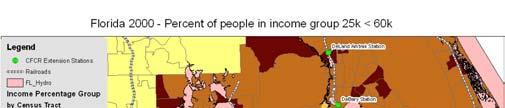
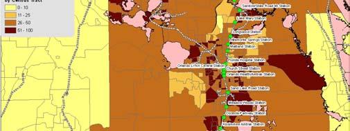
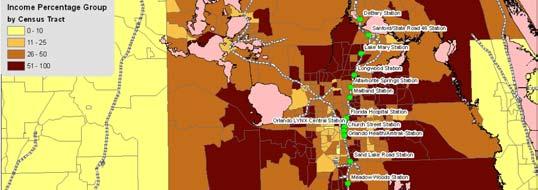
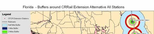
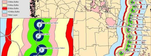
6 CTPP Flow Data for Commuter Rail Systems Production Buffer - 2 miles and Attraction buffer - 1 mile Income Group Employment Density Baltimore Dallas Los Angeles Miami San Diego San Francisco San Jose Seattle Virginia Low 50,000+ 6, ,661-1,349 2,262-2,677 2,372 Medium 50, ,614 1,257 3,702-2,594 5,925-5,187 7,300 High 50, ,945 1,337 4,394-3,167 11,981-4,807 14,630 Low <50,000 9,828 1,066 24,196 8,175 2,528 13,018 2,424 2,126 2,787 Medium <50,000 29,844 2,712 67,066 18,968 6,109 48,292 6,478 5,527 10,843 High <50,000 45,866 2,471 78,695 15,110 8, ,648 13,799 5,377 24,430 All All 121,224 9, ,714 42,253 24, ,126 22,701 25,701 62,362 PNR Production Buff - 6 miles and Attraction buffer - 1 mile Income Group Employment Density Baltimore Dallas Los Angeles Miami San Diego San Francisco San Jose Seattle Virginia Low 50, , , ,702-4,865 3,892-7,549 8,111 Medium 50, ,735 6,981 12,721-10,800 12,500-21,382 25,612 High 50, ,896 8,409 17,594-13,188 33,060-32,385 49,391 Low <50,000 19,259 4,318 52,916 20,439 7,090 19,856 6,153 6,046 7,758 Medium <50,000 63,225 11, ,003 53,085 18,476 77,599 20,600 19,626 29,306 High <50, ,700 10, ,689 48,694 26, ,163 53,376 26,690 63,601 All All 299,004 44, , ,218 80, ,070 80, , ,779 Computation of Demand Adjustment Factor and CTPP Calibration Ridership Baltimore Los Angeles San Diego San Francisco Dallas TRE Miami Tri-Rail San Jose ACE Seattle Sounder Virginia VRE Average Attribute MARC MetroLink Coaster Penn. JTP Avg Speed Ann Vehicle Miles/ RouteMile 12, ,289 8,422 12,794 12,880 27, , ,705 10,281.7 Base:Peak Ratio Passengers/Car Assumed Train Length Weekday Trn Miles/Route Mile Service Adjustments Speed vs Avg 11.8% -61.7% 14.6% -1.7% 19.2% -10.6% 4.7% 9.5% -5.5% Adjusted Demand Factor Weekday Trn Miles/Mile 16.7% -48.2% -19.9% 21.8% 22.4% 92.0% % % -16.6% Adjusted Demand Fact Rail Connection Index Total Demand Adjustment Factor CTPP Calibration Demand 19,180 6,066 26,795 6,965 3,834 24,782 12,646 4,355 8,621


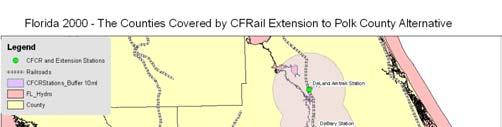
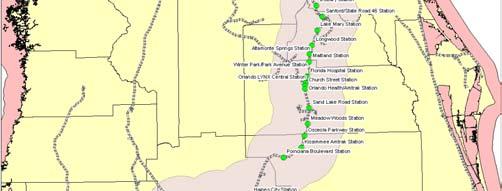
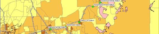
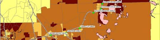
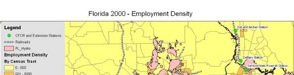
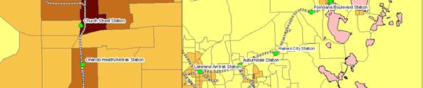
7 Proposed Rail Alternatives CSX Corridor Regional Rail Alternative I-4 Corridor Regional Rail Alternative to Orlando Airport I-4 Corridor Regional Rail Alternative to Orlando CBD Tampa to Polk County Rail Alternative CFRail Extension to Polk County ALternative
8
9

10
11 Reliability of ARRF Model New new start transit line Access mode Other transportation mode connection Discrepancy of ARRF and Regional Planning Model due to demand projection and mode split New rail line btw CBD and suburban with existing service CBD connections where each CBD has transit system New commuter rail line connecting to commuter bus services Questions: 299 Madison Ave Morristown, NJ 07962
RIDERSHIP PREDICTION
 RIDERSHIP PREDICTION Outline 1. Introduction: route ridership prediction needs and issues. 2. Alternative approaches to route ridership prediction. Professional judgement Survey-based methods Cross-sectional
Rail Station Fact Sheet CentrePort/DFW Airport Station
 Rail Station Fact Sheet CentrePort/DFW Airport Station Station Overview CentrePort/DFW Airport Station is located by Statler Boulevard at Breezewood Drive in Fort Worth. Free shuttles connect the station
Pinellas County. Transportation Task Force. June 21, 2010
 Pinellas County Transportation Task Force June 21, 2010 1 Welcome and Introductions Karen Williams Seel, Pinellas Board of County Commissioners 2 Agenda Approval of Minutes MPO Long Range Plan Brian Smith,
Sustainable Transportation Planning in the Portland Region
 Sustainable Transportation Planning in the Portland Region Jennifer Dill, Ph.D. Associate Professor School of Urban Studies & Planning jdill@pdx.edu http://web.pdx.edu/~jdill/ Outline Elements of a sustainable
SOUNDCAST CALIBRATION AND SENSITIVITY TEST RESULTS (DRAFT) TABLE OF CONTENTS. Puget Sound Regional Council. Suzanne Childress.
 TABLE OF CONTENTS. Puget Sound Regional Council. Suzanne Childress.") SOUNDCAST CALIBRATION AND SENSITIVITY TEST RESULTS (DRAFT) Puget Sound Regional Council Suzanne Childress June 2015 This document describes the activity-based model calibration to the 2010 using the following
SOUNDCAST CALIBRATION AND SENSITIVITY TEST RESULTS (DRAFT) Puget Sound Regional Council Suzanne Childress June 2015 This document describes the activity-based model calibration to the 2010 using the following
Presentation Summary Why Use GIS for Ped Planning? What Tools are Most Useful? How Can They be Applied? Pedestrian GIS Tools What are they good for?
 1 2 Pedestrian GIS Tools What are they good for? Pro Walk / Pro Bike 2006 Presentation Summary Why Use GIS for Ped Planning? What Tools are Most Useful? How Can They be Applied? Matt Haynes Fehr & Peers
Transit Signal Priority (TSP) Application to Miami-Dade Transit
 Application to Miami-Dade Transit") Transit Signal Priority (TSP) Application to Miami-Dade Transit Amar Sarvepalli Parsons Brinckerhoff Southeast Florida FSUTMS Users Group August 15, 2008 Overview PART A WHAT IS TSP INTRODUCTION PURPOSE
Transit Signal Priority (TSP) Application to Miami-Dade Transit Amar Sarvepalli Parsons Brinckerhoff Southeast Florida FSUTMS Users Group August 15, 2008 Overview PART A WHAT IS TSP INTRODUCTION PURPOSE
the 54th Annual Conference of the Association of Collegiate School of Planning (ACSP) in Philadelphia, Pennsylvania November 2 nd, 2014
 in Philadelphia, Pennsylvania November 2 nd, 2014") the 54th Annual Conference of the Association of Collegiate School of Planning (ACSP) in Philadelphia, Pennsylvania November 2 nd, 2014 Hiroyuki Iseki, Ph.D. Assistant Professor Urban Studies and Planning
the 54th Annual Conference of the Association of Collegiate School of Planning (ACSP) in Philadelphia, Pennsylvania November 2 nd, 2014 Hiroyuki Iseki, Ph.D. Assistant Professor Urban Studies and Planning
METRO Light Rail: Changing Transit Markets in the Phoenix Metropolitan Area
 METRO Light Rail: Changing Transit Markets in the Phoenix Metropolitan Area Abhishek Dayal, AICP Planner III, METRO Light Rail Phoenix, AZ BACKGROUND Transit in the Phoenix Region Transit services in the
6.0 PEDESTRIAN AND BICYCLE FACILITIES 6.1 INTRODUCTION 6.2 BICYCLE DEMAND AND SUITABILITY Bicycle Demand
 6.0 PEDESTRIAN AND BICYCLE FACILITIES 6.1 INTRODUCTION Bicycle and pedestrian travel along and in the vicinity of the corridor is part of the vision of Somerset and Hunterdon counties and the integrated
2017 Northwest Arkansas Trail Usage Monitoring Report
 2017 Northwest Arkansas Trail Usage Monitoring Report Summary Findings: The study showed that average daily weekday bicycle volumes per study site increased by about 32% between 2015 and 2017, from 142
TAMPA BAY EXPRESS (TBX)
") TAMPA BAY EXPRESS (TBX) Hank Schneider, P.E. FDOT- District 7 Consultant Project Manager Florida Department of TRANSPORTATION TAMPA BAY EXPRESS AGENDA What is TBX? What does TBX do? Why is TBX Important?
TAMPA BAY EXPRESS (TBX) Hank Schneider, P.E. FDOT- District 7 Consultant Project Manager Florida Department of TRANSPORTATION TAMPA BAY EXPRESS AGENDA What is TBX? What does TBX do? Why is TBX Important?
Bike Planner Overview
 Bike Planner Overview A Web-based Sketch Planning Tool for Los Angeles County presented by William E. Walter, GISP April 12, 2017 GIS-T Transportation leadership you can trust. Bike Planner Overview Guiding
El Paso to Las Cruces Proposed Rail Service Estimated Ridership and Proposed Schedule
 to Las Cruces Proposed Rail Service Estimated Ridership and Proposed Schedule Ridership estimation is a central consideration when assessing the feasibility of a proposed transit line. A sketch model is
Richmond Area MPO Regional Transportation and Land Use Performance Measures 2013
 Richmond Area MPO Regional Transportation and Land Use Performance Measures 2013 Richmond Area October 2013 REGIONAL PERFORMANCE MEASURES FOR RICHMOND AREA MPO Rows that are shaded are categories of regional
Toll Express Lanes for the Research Triangle region Including discussion of possible applications on I-40
 Toll Express Lanes for the Research Triangle region Including discussion of possible applications on I-40 Presentation for discussion at Durham-Chapel Hill-Carrboro MPO TAC meeting Wednesday, December
Pedestrian Demand Modeling: Evaluating Pedestrian Risk Exposures
 Pedestrian Demand Modeling: Evaluating Pedestrian Risk Exposures Kelly J. Clifton National Center for Smart Growth University of Maryland May 19, 2008 Study Team University of Maryland National Center
. ' motion. APPLtlDK.L - L"iLC_t1GLR 201b APPENDIX 7 TECHNICAL MEMOS
 . ' motion APPLtlDK.L - L"iLC_t1GLR 201b APPENDIX 7 TECHNICAL MEMOS The nmotion program will provide a large number of benefits for Middle Tennessee. This document presents selected benefits and other
Travel Demand Methodology Report. Durham Orange Light Rail Transit Project
 Durham Orange Light Rail Transit Project September 2012 TABLE OF CONTENTS 1. Introduction... 1 1 1.1. STUDY BACKGROUND... 1 1 1.2. RECENT PROJECT AND STUDIES... 1 2 1.3. CURRENT WORK PROGRAM... 1 3 2.
Feasibility Study Danbury Branch Electrification. Task 3 Report Ridership Forecasting. Table of Contents
 Connecticut Department of Transportation Washington Group International FINAL Task 3 Report Ridership Forecasting Task 3 Report Ridership Forecasting Table of Contents 1.0 Background 2.0 Approach 3.0 Summary
Preview. Tables in your paper Mass Transit as alternative to auto California s problems in urban transportation
 Preview Tables in your paper Mass Transit as alternative to auto California s problems in urban transportation Integrating tables in your writing Commuting in Urban Areas Last time auto and congestion
Transit Ridership - Why the Decline and How to Increase. Hosted by the. Virginia Transit Association
 Transit Ridership - Why the Decline and How to Increase Hosted by the Virginia Transit Association Virginia Transit Association 1108 East Main Street, Suite 1108 Richmond, VA 23219 804.643.1166 www.vatransit.com
Guidelines for Providing Access to Public Transportation Stations APPENDIX C TRANSIT STATION ACCESS PLANNING TOOL INSTRUCTIONS
 APPENDIX C TRANSIT STATION ACCESS PLANNING TOOL INSTRUCTIONS Transit Station Access Planning Tool Instructions Page C-1 Revised Final Report September 2011 TRANSIT STATION ACCESS PLANNING TOOL INSTRUCTIONS
Webinar: Development of a Pedestrian Demand Estimation Tool
 Portland State University PDXScholar TREC Webinar Series Transportation Research and Education Center (TREC) 2-18-2016 Webinar: Development of a Pedestrian Demand Estimation Tool Kelly Clifton Portland
Market Factors and Demand Analysis. World Bank
 Market Factors and Demand Analysis Bank Workshop and Training on Urban Transport Planning and Reform. Baku, April 14-16, 2009 Market Factors The market for Public Transport is affected by a variety of
CHAPTER 8 APPLICATION AND INTERPRETATION OF CONGESTION MEASURES
 CHAPTER 8 APPLICATION AND INTERPRETATION OF CONGESTION MEASURES Chapter Summary The focus of this chapter is to provide the reader with practical applications and interpretation of the congestion measures
Philadelphia Bus Network Choices Report
 Philadelphia Bus Network Choices Report JUNE 2018 SEPTA Table of Contents Executive Summary...7 What if transit gave us more freedom?... 8 What is this report?... 8 The main conclusions... 9 What is happening
VIRGINIA RAILWAY EXPRESS
 PREPARING FOR THE NEXT QUARTER-CENTURY Arlington County Board Work Session June 28, 2017 1 TODAY S PRESENTATION VRE Overview VRE in Arlington County VRE System 2040 Plan Future Vision for Crystal City
Community Engagement Process
 Community Engagement Process PHASE ONE PURPOSE + NEED STATEMENT IDEAS DESTINATIONS TRAVEL PATTERNS PHASE TWO MODE SELECTION INPUT PHASE THREE LOCALLY PREFERRED ALTERNATIVE SELECTION OF PREFERRED ALTERNATIVE
A Federal Perspective on Congestion Pricing. Wayne Berman Federal Highway Administration July 8, 2010
 A Federal Perspective on Congestion Pricing Wayne Berman Federal Highway Administration July 8, 2010 Overview Background on Congestion Pricing Benefits and Experiences of Pricing Case Study Miami I-95
Tulsa Metropolitan Area LONG RANGE TRANSPORTATION PLAN
 Tulsa Metropolitan Area LONG RANGE TRANSPORTATION PLAN Indian Nations Council of Governments August 2005 CONTACTING INCOG In developing the Destination 2030 Long Range Transportation Plan, INCOG s Transportation
Demand Estimation Model for Park-and-Ride Service: Fort Bend County to Central Houston
 Demand Estimation Model for Park-and-Ride Service: Fort Bend County to Central Houston 1 Investigation of past and present methods/thoughts LITERATURE/SOURCE REVIEW RELATIVE DEMAND ESTIMATION 2 General
Westside Transportation Access Needs Assessment - Short and Long Term Improvements
 ABSTRACT The Los Angeles County Metropolitan Transportation Authority (MTA) adopted the 2001 Long Range Transportation Plan (LRTP), which sets out the County s transportation investments for the next 20-25
VI. Market Factors and Deamnd Analysis
 VI. Market Factors and Deamnd Analysis Introduction to Public Transport Planning and Reform VI-1 Market Factors The market for Public Transport is affected by a variety of factors No two cities or even
APPENDIX E BIKEWAY PRIORITIZATION METHODOLOGY
 APPENDIX E BIKEWAY PRIORITIZATION METHODOLOGY INTRODUCTION The network of bikeways recommended in the Bicycle Master Plan is extensive and is likely to be only partially completed during the 25-year life
ADOT Statewide Bicycle and Pedestrian Program Summary of Phase IV Activities APPENDIX B PEDESTRIAN DEMAND INDEX
 ADOT Statewide Bicycle and Pedestrian Program Summary of Activities APPENDIX B PEDESTRIAN DEMAND INDEX May 24, 2009 Pedestrian Demand Index for State Highway Facilities Revised: May 29, 2007 Introduction
Webinar- Importance of Multi- Modal Transit Connections and Fare Policy for Regional Transit Mobility & Equity
 Webinar- Importance of Multi- Modal Transit Connections and Fare Policy for Regional Transit Mobility & Equity Thomas Marchwinski Metro North RR (Previously with NJ Transit) Importance of Multi-Modal Transit
ORANGE COUNTY TRANSPORTATION AUTHORITY. Metrolink Ridership and Revenue Quarterly Report. Staff Report
 ORANGE COUNTY TRANSPORTATION AUTHORITY Metrolink Ridership and Revenue Quarterly Report Staff Report March 8, 2012 To: From: Subject: Transit Committee Will Kempton, Chief Executive Officer Metrolink Ridership
Predicted vs. Actual Costs and Ridership - Urban Transport Projects
 Predicted vs. Actual Costs and Ridership - Urban Transport Projects Lessons from the US presented by Steve Lewis-Workman, Transport Economist East Asia Department, Transport Division ADB Transport Forum
TCRP PROJECT H-1 Transit and Urban Form COMMUTER AND LIGHT RAIL TRANSIT CORRIDORS: THE LAND USE CONNECTION
 TCRP PROJECT H-1 Transit and Urban Form COMMUTER AND LIGHT RAIL TRANSIT CORRIDORS: THE LAND USE CONNECTION Prepared for Transit Cooperative Research Program Transportation Research Board National Research
EXECUTIVE SUMMARY... vii 1 STUDY OVERVIEW Study Scope Study Area Study Objectives
 Contents EXECUTIVE SUMMARY... vii 1 STUDY OVERVIEW... 1-1 1.1 Study Scope... 1-1 1.2 Study Area... 1-1 1.3 Study Objectives... 1-3 2 EXISTING CONDITIONS... 2-1 2.1 Existing Freeway Conditions... 2-4 2.1.1
Preview. Second midterm Tables in your paper Mass Transit as alternative to auto California s problems in urban transportation
 Preview Second midterm Tables in your paper Mass Transit as alternative to auto California s problems in urban transportation Score Distribution 1 st Midterm 2 nd Midterm 3.5-4.0 8% 21% 3.0-3.5 23% 34%
Summary of NWA Trail Usage Report November 2, 2015
 Summary of NWA Trail Usage Report November 2, 2015 Summary Findings: The study showed that Northwest Arkansas (NWA) had relatively high cyclist user counts per capita aggregated across the top three usage
Bicycle Demand Forecasting for Bloomingdale Trail in Chicago
 Bicycle Demand Forecasting for Bloomingdale Trail in Chicago Corresponding Author: Zuxuan Deng Arup Water Street, New York, NY 000 zuxuan.deng@arup.com Phone:.. Fax:..0 Matthew Sheren Arup Water Street,
REGIONAL HOUSEHOLD TRAVEL SURVEY:
 Defining the Vision. Shaping the Future. REGIONAL HOUSEHOLD TRAVEL SURVEY: Profile Why we travel How we travel Who we are and how often we travel When we travel Where we travel How far and how long we travel
Rail Station Fact Sheet University of Dallas Station
 Rail Station Fact Sheet University of Dallas Station Station Overview University of Dallas Station is located on John Carpenter Freeway and west of Loop 12 across from the University of Dallas in Irving.
Rail Station Fact Sheet DFW Airport North Station* (*station under construction with anticipated start of service in late 2018)
") Rail Station Fact Sheet DFW Airport North Station* (*station under construction with anticipated start of service in late 018) Station Overview DFW Airport North Station will be located on DFW nternational
Rail Station Fact Sheet DFW Airport North Station* (*station under construction with anticipated start of service in late 018) Station Overview DFW Airport North Station will be located on DFW nternational
Estimating Ridership of Rural Public Demand- Response Transit
 Estimating Ridership of Rural Public Demand- Response Transit Wednesday, November 16, 2016 U.S. Department of Transportation Federal Transit Administration Jeremy Mattson Associate Research Fellow, Small
Presentation of Staff Draft March 18, 2013 COUNTYWIDE TRANSIT CORRIDORS FUNCTIONAL MASTER PLAN
 Presentation of Staff Draft March 18, 2013 COUNTYWIDE TRANSIT CORRIDORS FUNCTIONAL MASTER PLAN Public Outreach Fall 2011: Two community meetings/open houses Fall 2012: Three community meetings/open houses
DART Ridership. Board Workshop January 5, 2018
 DART Ridership Board Workshop January 5, 2018 0 Overview This presentation looks at many facets of DART s bus and rail ridership trends. No single factor can adequately explains the current trends Key
Transit Operations in the I-95 Express Lanes
 Transit Operations in the I-95 Express Lanes TRB 15 th International Conference on Managed Lanes Miami, Florida Presented by Diane Quigley FDOT Transit Planning Administrator May 5, 2016 FDOT Governance
I-105 Corridor Sustainability Study (CSS)
") I-105 Corridor Sustainability Study (CSS) Metro Streets and Freeways Subcommittee March 21, 2019 Gary Hamrick Cambridge Systematics, Inc. I-105 CSS Project History & Background Funded by Caltrans Sustainable
I-105 Corridor Sustainability Study (CSS) Metro Streets and Freeways Subcommittee March 21, 2019 Gary Hamrick Cambridge Systematics, Inc. I-105 CSS Project History & Background Funded by Caltrans Sustainable
Rail Station Fact Sheet Downtown Carrollton Station
 Rail Station Fact Sheet Downtown Carrollton Station Station Overview Downtown Carrollton Station is located at East Belt Line Road and Broadway Street near the historic Downtown Carrollton Square. The
Rail Station Fact Sheet CityLine/Bush Station
 Rail Station Fact Sheet CityLine/Bush Station Station Overview CityLine/Bush Station is located just south of the President George Bush Turnpike and east of US 75 in Richardson. The station opened in 00
Hotel InduSTRy Overview What Lies Ahead
 Hotel InduSTRy Overview What Lies Ahead Vail R. Brown Vice President, Global Business Development & Marketing www.hotelnewsnow.com Click on Hotel Data Presentations U.S. In Review Demand Growth Strong.
Transit Pre-Planning and Data Collection for Multi-Modal Corridor Studies
 Transit Pre-Planning and Data Collection for Multi-Modal Corridor Studies November 15 th, 2013 Topics Motivations Overview Results and findings Reactions and refinements Page 2 MOTIVATIONS The Problem
Travel and Rider Characteristics for Metrobus
 Travel and Rider Characteristics for Metrobus 040829040.15 Travel and Rider Characteristics for Metrobus: 2012-2015 Overview The Miami Dade County Metropolitan Planning Organization (MPO) conducted a series
SOUTH JERSEY TRANSPORTATION PLANNING ORGANIZATION
 SOUTH JERSEY TRANSPORTATION PLANNING ORGANIZATION Model Validation Analysis January 16, 2013 Acknowledgements The preparation of this report has been financed in part by the U.S. Department of Transportation,
Public Transport and Development: Making It Work
 Public Transport and Development: Making It Work Robert T. Dunphy Urban Land Institute World Bank Transport Forum 2006 March 28, 2006 Transportation Development Disconnect Now Few Then places w/o car Many
ABSTRACT PEDESTRIAN - VEHICULAR CRASHES: THE INFLUENCE OF PERSONAL AND ENVIRONMENTAL FACTORS. Carolina V. Burnier, M.Sc., 2005
 ABSTRACT Title: PEDESTRIAN - VEHICULAR CRASHES: THE INFLUENCE OF PERSONAL AND ENVIRONMENTAL FACTORS Carolina V. Burnier, M.Sc., 2005 Directed By: Dr. Kelly J. Clifton, Department of Civil and Environmental
Community Transportation Plan Acknowledgements
 Community Transportation Plan Acknowledgements The Decatur CTP was developed with participation and guidance from City of Decatur staff, its Resident Boards and Commissions, and numerous residents, business
Rail Station Fact Sheet UNT Dallas Station
 Rail Station Fact Sheet UNT Dallas Station Station Overview UNT Dallas Station is located on the east side of University Hills Boulevard in Dallas. t is connected by a walking path to the University of
Lodging Market Update. Valley Hotel and Resort Association April 13, 2016 Presented by: Robert Hayward
 Lodging Market Update Valley Hotel and Resort Association April 13, 2016 Presented by: Robert Hayward United States Lodging Market 63.7% 59.8% 58.9% 59.2% 61.3% 63.1% 63.3% 63.1% 60.3% 55.1% 57.5% 59.9%
PEDESTRIAN COLLISIONS IN LOS ANGELES 1994 through 2000
 PEDESTRIAN COLLISIONS IN LOS ANGELES 1994 through 2000 City of Los Angeles Department of Transportation Gloria Jeff, General Manager March, 2006 This document printed with grant funds from the California
2010 Pedestrian and Bicyclist Special Districts Study Update
 2010 Pedestrian and Bicyclist Special Districts Study Update Pedestrian and Bicyclist Special Districts Program Overview H-GAC s Special Districts Program aims to provide strategic investments in pedestrian
San Mateo County Comprehensive Bicycle and Pedestrian Plan
 San Mateo County Comprehensive Bicycle and Pedestrian Plan August 26, 2010 Presented to the San Mateo County BPAC by Lauren Ledbetter, Alta Planning + Design in association with: Fehr & Peers Eisen Letunic
Key objectives of the survey were to gain a better understanding of:
 3 COMMUNITY INPUT Community input is an essential part of corridor studies. For the SR 87 corridor study, VTA staff conducted an extensive online survey of people living and commuting along the corridor.
FY2006 Budget Board Budget Committee request for information. Board Request: Detailed information on bus route 5A DC-Dulless Airport
 Board Request: Detailed information on bus route 5A DC-Dulless Airport Tracking Number: 29 Assigned to Dept/Office: OPER Contact Person: Jim Hughes Metrobus Route 5A was established in December 2000 in
Impact of Shared Mobility and Technology on Public Transportation
 Impact of Shared Mobility and Technology on Public Transportation Susan Shaheen, PhD Email: sshaheen@berkeley.edu Twitter: SusanShaheen1 LinkedIn: Susan Shaheen Overview Defining shared mobility and impacts
Ridership Demand Analysis for Palestinian Intercity Public Transport
 Ridership Demand Analysis for Palestinian Intercity Public Transport Khaled A. Al-Sahili and Abdelmajid H. Sadeq An-Najah National University Abstract This article presents results of research to study
Calgary Transit Route 302 Southeast BRT Year One Review June
 Calgary Transit Route 302 Southeast BRT Year One Review 2011 June Calgary Transit Route 302 Southeast BRT: Year One Review 2011 April Table of Contents 1.0 Executive Summary... 1 2.0 Introduction... 3
THE MOST INFORMATIVE EVENT COVERING REAL ESTATE INVESTMENTS
 THE MOST INFORMATIVE EVENT COVERING REAL ESTATE INVESTMENTS 2014 U.S. Economic, Capital Markets, and Retail Market Overview and Outlook Retail Trends 2014 U.S. Economic Overview and Outlook Total Employment
ID Layer Name Group Layer Name Layer Attributes Layer Source Layer Description Update Frequency
 1 County Boundaries Base Data/Jurisdictional Boundaries 1. County; 2. County Seat; 3Largest City; 4. Area (SQM); 5. Population (2012) FGDL This dataset provides location and attribute information on all
Table of Contents. 2.0 Land Use and Transportation Inputs Land Use Factors Transportation Factors
 TransAction 2040 Plan Table of Contents 1.0 Overview of the TransAction 2040 Plan... 1-1 1.1 Background... 1-1 1.2 Process... 1-6 1.3 Organization of TransAction 2040 Plan... 1-7 2.0 Land Use and Transportation
1999 On-Board Sacramento Regional Transit District Survey
 SACOG-00-009 1999 On-Board Sacramento Regional Transit District Survey June 2000 Sacramento Area Council of Governments 1999 On-Board Sacramento Regional Transit District Survey June 2000 Table of Contents
City of Davenport CitiBus Public Transportation Study. April 2015
 City of Davenport CitiBus Public Transportation Study April 2015 Overview Project Background Key Findings CitiBus Service Allocation Policy Discussion 2 Project Background 3 About CitiBus Operates 17 routes
Provo City Transportation Master Plan
 Provo City Transportation Master Plan Provo, Utah Adopted: September, 011 UT09-1 1 West Mayflower Way, Ste. Lehi, Utah 80 p. 801/. www.halesengineering.com September, 011 EXECUTIVE SUMMARY Provo City is
3 ROADWAYS 3.1 CMS ROADWAY NETWORK 3.2 TRAVEL-TIME-BASED PERFORMANCE MEASURES Roadway Travel Time Measures
 ROADWAYS Approximately 6 million trips are made in the Boston metropolitan region every day. The vast majority of these trips (80 to percent, depending on trip type) involve the use of the roadway network
Flyaway Bus: GIS Analysis on Current and Potential Ridership, Revenue, and Prospective Stations
 ProfessorBarry Waite & Bonnie Shrewsbury Flyaway Bus: GIS Analysis on Current and Potential Ridership, Revenue, and Prospective Stations 1. Abstract The Flyaway Bus is a long distance non-stop shuttle
Midtown Corridor Alternatives Analysis
 Midtown Corridor Alternatives Analysis Ridership Forecast Methodology and Results December 2013 Prepared by the SRF Consulting Group Team for Table of Contents Introduction... 1 Methodology... 1 Assumptions...
2045 Long Range Transportation Plan. Summary of Draft
 2045 Long Range Transportation Plan Summary of Draft Fredericksburg Area Metropolitan Planning Organization The George Washington Region includes the City of Fredericksburg and the counties of Caroline,
CHAPTER 1 A 1 PURPOSE AND NEED
 CHAPTER 1 A 1 PURPOSE AND NEED The Federal Transit Administration (FTA) and the Los Angeles County Metropolitan Transportation Authority (Metro) propose the Westside Subway Extension Project (Project),
Health Impact Analysis for Integrated Regional Land Use and Transportation Plan
 Health Impact Analysis for Integrated Regional Land Use and Transportation Plan Hsi-Hwa Hu, Guoxiong Huang, Frank Wen, Simon Choi (Southern California Association of Governments) Margaret Shih (Los Angeles
Community Transit Solutions for the Suburbs APTA Annual Meeting Steve Fittante, New Jersey Transit Corporation September 30, 2013
 Community Transit Solutions for the Suburbs APTA Annual Meeting Steve Fittante, New Jersey Transit Corporation September 30, 2013 New Suburban Challenges Lower density development patterns Where is the
Fixed Guideway Transit Outcomes on Rents, Jobs, and People and Housing
 Fixed Guideway Transit Outcomes on Rents, Jobs, and People and Housing Arthur C. Nelson, Ph.D., ASCE, FAICP Professor of Planning and Real Estate Development University of Arizona 1 Changing Transportation
Central Jersey Transportation Forum. March 2007
 Central Jersey Transportation Forum March 2007 Feasibility Analysis of BRT on Dinky Right of Way from Princeton Station to Alexander Rd. in West Windsor (west of Rt. 1) Study spurred by Princeton University's
Community Task Force July 25, 2017
 Community Task Force July 25, 2017 Welcome and Introductions Project Partners Regional Transportation District (RTD) Colorado Department of Transportation (CDOT) Denver Regional Council of Governments
Potential MBTA Fare Changes in SFY 2017
 Potential MBTA Fare Changes in SFY 2017 Option 1 Impact Analysis A report produced for the Massachusetts Bay Transportation Authority by the Central Transportation Planning Staff Potential MBTA Fare Changes
Appendix T 1: Additional Supporting Data
 Appendix T 1: Additional Supporting Data Project Delivery Delays with the implementation of the 2000 TIP became apparent early in the decade. In response to direction among policy officials, ARC began
Subject: Solberg Avenue / I-229 Grade Separation: Traffic Analysis
 MEMORANDUM Transportation Bill Troe, AICP Jason Carbee, AICP 12120 Shamrock Plaza Suite 300 Omaha, NE 68154 (402) 334-8181 (402) 334-1984 (Fax) To: Project File Date: Subject: Solberg Avenue / I-229 Grade
Rail Station Fact Sheet Buckner Station
 Rail Station Fact Sheet Buckner Station Station Overview Buckner Station is located at the intersection of Buckner Boulevard and Elam Road in Dallas. The station opened in 2010 and currently serves as
The Broadway SkyTrain Extension
 The Broadway SkyTrain Extension Grandview Woodland Citizens Assembly Lon LaClaire Manager, Strategic Transportation Planning, City of Vancouver January 24, 2015 Commercial-Broadway is a Transit Crossroads
Estimating Ridership of Rural Demand-Response Transit Services for the General Public
 Estimating Ridership of Rural Demand-Response Transit Services for the General Public August 2016 prepared for US DOT prepared by Jeremy Mattson North Dakota State University Upper Great Plains Transportation
Gateway Cities Maximum Transit Scenario Assessment Final Draft
 Gateway Cities Maximum Scenario Assessment Final Draft Date: March 11, 2014 Prepared for: Gateway Cities Council of Governments Los Angeles County Metropolitan Transportation Authority Prepared by: 445
Webinar: The Association Between Light Rail Transit, Streetcars and Bus Rapid Transit on Jobs, People and Rents
 Portland State University PDXScholar TREC Webinar Series Transportation Research and Education Center (TREC) 11-15-2016 Webinar: The Association Between Light Rail Transit, Streetcars and Bus Rapid Transit
SMART 1 Public Meeting #1. February 24, 2016
 SMART 1 Public Meeting #1 February 24, 2016 Agenda Who is the SMTC? SMART 1 project overview Syracuse Metropolitan Transportation Council An Introduction: Who we are & what we do What is an MPO? A Metropolitan
Overview of 64 Express Lanes. Secretary of Transportation Aubrey Layne April 12, 2017
 Overview of 64 Express Lanes Secretary of Transportation Aubrey Layne April 12, 2017 2 More Choices for Motorists Coming December 2017 Purpose and Use Our purpose is two-fold: Reduce congestion by making
Pedestrian Activity Criteria. PSAC March 8, 2011
 Pedestrian Activity Criteria PSAC March 8, 2011 Contents 1. Project Overview a) Revised schedule of PSAC hearings 2. Pedestrian Activity: Where walking is important a) Existing conditions (revisions based
Dr. Richard Wobbekind Executive Director, Business Research Division and Senior Associate Dean for Academic Programs University of Colorado Boulder
 Dr. Richard Wobbekind Executive Director, Business Research Division and Senior Associate Dean for Academic Programs University of Colorado Boulder Member FDIC VectraBank.com Economic Outlook 2015 Richard
Capital and Strategic Planning Committee. Item III - B. April 12, WMATA s Transit-Oriented Development Objectives
 Capital and Strategic Planning Committee Item III - B April 12, 2018 WMATA s Transit-Oriented Development Objectives Page 24 of 76 Washington Metropolitan Area Transit Authority Board Action/Information