Overview of Report 803 Research Approach Case Studies Spreadsheet Tool Demo Question and Answer session. Photo by Michael Hintze
|
|
|
- Matilda Lucas
- 5 years ago
- Views:
Transcription

1 Overview of Report 803 Research Approach Case Studies Spreadsheet Tool Demo Question and Answer session Photo by Michael Hintze
2 NCHRP Pedestrian and Bicycle Transportation along Existing Roads Project Goals: Analyze institutional approaches for improving physical conditions for pedestrians and bicyclists Evaluate prioritization factors including safety, accessibility, connectivity, health benefits, and economic development Identify data gaps and research needs Develop a methodology to evaluate and prioritize pedestrian and bicycle facility improvements on existing roads

3 APT Guidebook GIS guidance Programmed Spreadsheet and User Guide Screencast Brochure/Poster NCHRP 803 Final Report with research approach and findings

4 Lots of needs, but limited resources Need to make wise choices about how resources are used Need to communicate choices to others Need to build public/political support for action Photo by Michael Hintze

5 May be applied at state, regional, and local levels. Can be applied at variety of geographies: segments, intersections, corridors, areas May be applied once or iteratively Does not provide guidance for determining pedestrian and bicycle facility design solutions Photo by Robert Schneider

6 Planning Level Prioritization Project Prioritization Engage stakeholders/public in prioritization process Conduct funding-decision prioritization Prioritize list of Complete Streets projects to maximize benefits for walking or biking. Photo by Toole Design Group

7 Literature review Survey Interviews with transportation agencies Feedback from NCHRP panel Pilot tests Photo by Toole Design Group
8 Agency Type Population Yountville, CA* City 3,000 Breckenridge, CO City 4,540 Cheverly, MD* City 6,200 Madras, OR* City 6,250 Houghton, MI City 7,700 Salisbury, NC City 34,000 Burlington, VT City 42,000 Carmel, IN City 79,000 Roseville, CA City 119,000 French Broad River MPO (Asheville, NC area) MPO 417,000 Portland, OR City 584,000 Wilmington Area Planning Council (DE-MD) MPO 640,000 Charlotte, NC City 731,000 Knoxville RTPO MPO 850,000 Delaware DOT State 907,000 Massachusetts DOT State 6,587,000 North Carolina DOT State 9,656,000 Washington State DOT State 6,830,000 Michigan DOT State 9,876,000

9 Pilot Communities Bellingham, WA Bend, OR Carmel, IN Gastonia, NC Miami, FL Phoenix, AZ Alameda County, CA Transportation Commission Casper Area MPO, WY Humboldt County, CA Association Of Governments New Mexico DOT Figure 9: Communicating Prioritization Process by Mapping Selected Factors--Example from City of Bellingham, Washington Bicycle Master Plan

10 No need to reinvent the wheel Different levels of technical capabilities, data, etc --> need to be flexible Open the black box Develop common language Offer guidance for important decision points Photo by Robert Schneider

11

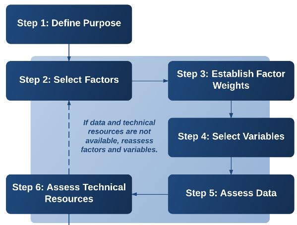
12 Mode Goals Improvement-specific vs. general location Type/extent of improvement locations Number of improvement locations Photo by Michael Hintze

13 1. Stakeholder Input 2. Constraints 3. Opportunities 4. Safety 5. Existing Conditions 6. Demand 7. Connectivity 8. Equity 9. Compliance Photo by Michael Hintze
14 Stakeholder Input Constraints Opportunities Safety Existing Conditions Demand Connectivity Equity Compliance Prioritization Purpose Examples Segment Given a neighborhood where sidewalks are absent, select 30 segments to construct new sidewalks over the next three years Intersection/Crossing Given a regional trail with 50 unsignalized roadway crossings, identify 12 crossings for safety enhancements = Very relevant; = Less relevant; = Not likely relevant


15 Nine Factors Equally Weighted Four Factors Equally Weighted Relative impact of factors if weighted differently Nine Factors Factors 1 and 2 weighted more heavily Four Factors Factor 1 weighted more heavily
16 Set of possible variables is included for each factor category Possible variables came from: Literature review Agency survey Best practice guidance from organizations such as NCHRP, FHWA, AASHTO, NACTO, and ITE. Professional experience of research team
17 Variable Traffic speed in the parallel direction of travel or roadway being crossed Pedestrian Level of Service (LOS) (Segment) Pedestrian Level of Service (LOS) (Uncontrolled Crossing) Pedestrian Level of Service (LOS) (Signalized Intersection) FHWA Crosswalk Guidelines Pedestrian Intersection Safety Index (ISI) X X X X X Pedestrian Crash Modification Factors Notes Traffic volume and composition (proportion heavy vehicles) in the parallel direction of travel or roadway being crossed X X X X Right-turn-on-red restricted/allowed X X Signal timing (e.g., leading pedestrian interval, pedestrian clearance time, pedestrian and bicycle delay) X Presence/type of traffic control (e.g., traffic signal, stop sign) Presence of crosswalk warning signs or beacons (e.g., in-street crossing signs, rectangular rapid flashing beacons, pedestrian hybrid beacon) Number of general-purpose (through) lanes in the parallel direction of travel or being crossed Number of designated right-turn lanes in the parallel direction of travel or roadway being crossed Total crossing distance X X X X X Note: A complete list of Existing Conditions variables is included in the APT Guidebook X X X See Schneid et al. (2010
18 Example Variables Relevance Potential Location Ped Bike Note: The relevance designations in this table are meant to provide general guidance. Ultimately, variable relevance depends on the prioritization purpose. Agencies are encouraged to review each variable and consider how relevant it may be considering their purpose. Appendix C provides references for the variables listed in this table to assist practitioners in finding additional information. = Very relevant = Less relevant = Not likely relevant S = Segment Cr = Crossing Co = Corridor A = Area Traffic speed 1 Cr, S, Co Traffic volume and composition (percentage of heavy vehicles) Cr, S, Co Right-turning traffic volume Cr Type of traffic control (e.g., traffic signal, stop sign) Cr Presence of crosswalk warning signage or beacons Cr Width of outside through lane S, Co Presence and width of buffer between sidewalk and moving traffic S, Co Note: A complete list of Existing Conditions variables is included in the APT Guidebook
19 Figure 1: Data Assessment Process Inventory readily available data (e.g., roadway data, land use, traffic counts) Seek other data sources (if necessary) (e.g., regional, state or federal agency data, open data sources) Collect new data (if necessary) Generate data from GIS analysis (see Step 8) High-level collection (e.g., using aerials, Street View imagery) Field verification/assessment Automatic (counters, video) Or- don t use that variable if no data is available!
20 Example Demand Proxy Variables Population density Employment density Transit station or stop density/proximity/accessibility Socioeconomic characteristics (e.g., proportion of neighborhood residents living in poverty or without access to an automobile) Proximity to or number of bike share docking stations Data Considerations/Sources Population of given geography divided by its area, U.S. Census Employment is often compiled at the regional level and made available to local agencies by request from the Census Transportation Planning Package for traffic analysis zones. Density is calculated by dividing the number of employees by a measure of area. Longitudinal Employer-Household Dynamics (LEHD) is another U.S. Census program that can provide employer/employee data estimates. Point data typically maintained by transit agency U.S. Census data (block group-level data may be most appropriate for projecting demand). Note: This type of data may also be used for variables within the Equity factor. Point data layer of bike share stations
21 Inventory Data Source/Tool Can be used to inventory data for these variables Aerial Imagery Sidewalk and buffer presence and width Marked crosswalk presence and type Median island presence and width Bicycle facility presence and width Lane width/shoulder width Pedestrian crossing distance Street-Level Imagery (e.g. video log, Street Curb ramp presence View) Truncated domes presence Pedestrian/bicycle-related signage Major sidewalk obstructions Pedestrian signal heads Pedestrian push buttons Direct Field Observation (using More precise lane width/shoulder width technological data collection tools or Traffic volume manual observations) Traffic speed Sidewalk condition Crosswalk condition Pavement condition Curb ramp slope On-street parking presence and occupancy


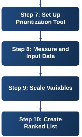
22 APT is intended to work for a range of technological capabilities GIS Example Source: Seattle Pedestrian Master Plan, 2009
23

24 Develop Demand Heat Map and Identify Corridors Prioritize Corridors and Separate into 3 Tiers Rank Improvements along Corridors Map by Lee Engineering
25 Calculating DEMAND Variable Schools Bus Stops City Facilities (e.g. libraries, municipal offices, etc.) Community Centers Light Rail Stops Park and Rides Parks Existing Bikeways Wikimap Routes Wikimap Destinations Source City of Phoenix City of Phoenix City of Phoenix City of Phoenix Valley Metro Valley Metro City of Phoenix City of Phoenix Wikimap Wikimap % of Households in Poverty U.S. Census % of Population under 18 U.S. Census % Households with No Vehicle U.S. Census Population Density City of Phoenix
 within 1 mile of the corridor Secondary attractors (schools, city facilities, community")
26 Factor Weight Variable Source Number of times corridor intersects other corridors N/A Connectivity 10 Number times corridor intersects bicycle N/A facilities Presence of existing bicycle facilities City of Phoenix Demand 7 Stakeholder Input 3 Primary attractors (light rail stops, colleges/universities) within 1 mile of the corridor Secondary attractors (schools, city facilities, community centers, park and rides, parks) within ¼ mile of the corridor. Also includes bus stops directly on the corridor Land Use (commercial and high-density housing) Population Density Valley Metro Google Maps City of Phoenix Valley Metro City of Phoenix City of Phoenix % Households in Poverty U.S. Census % Households with No Vehicle U.S. Census % of Population under 18 U.S. Census Bicycle Trip Origin and Destination Zip Codes from the Maricopa County Trip Reduction Survey Wikimap Destinations (included public meeting input and transit center surveys) Wikimap Routes (included public meeting input) Ad Hoc Task Force input Technical Advisory Committee input MAG Wikimap Wikimap Task Force TAC

27 Factor Variable Source Connectivity Bicycling Barriers Wikimap Existing Bikeways City of Phoenix Safety Bicycle Crashes MAG % of Population under 18 U.S. Census Existing Posted Speed Limit City of Phoenix Conditions Street Classification City of Phoenix Constraints Order of Magnitude Cost Lee Engineering Available Rights of Way City of Phoenix Demand Tier 1 Attractors (light rail stops, colleges/universities, schools) Valley Metro Google Maps Tier II Attractors (bus stops, bikeshare stations, city facilities, community centers, park-and-rides, parks) City of Phoenix Valley Metro Population Density Land Use (commercial and highdensity housing) Equity % Households in Poverty U.S. Census % Households with No Vehicle U.S. Census City of Phoenix Maricopa County

28 Good example of regional pedestrian and bicycle facility prioritization Project steering committee and INCOG Bicycle and Pedestrian Advisory Committee provided input on factors and factor weights City of Tulsa staff requested inclusion of additional variables for City projects had more data that could be used for prioritization


29 Prioritization lists included in plan appendix. INCOG and communities advised to use lists as guide
 Colorado Springs, CO Durham, NC Jacksonville, FL MassDOT Oregon DOT Wheat Ridge,")
30 Alexandria, VA Arvada, CO Bellingham, WA Boston Region MPO Casper, WY Charlottesville, VA Metropolitan Council (Twin Cities) Colorado Springs, CO Durham, NC Jacksonville, FL MassDOT Oregon DOT Wheat Ridge, CO
 versus creating a prioritization method from scratch Photo by Michael")
31 Transparent Flexible Responsive Supported by research Save time and effort ($$$) versus creating a prioritization method from scratch Photo by Michael Hintze

32 APT Guidebook Programmed Spreadsheet and User Guide and screencast GIS guidance Brochure NCHRP 803 Final Report with research approach and findings


33 Jim Elliott, AICP Toole Design Group, LLC Michael Hintze, AICP Toole Design Group, LLC
PBIC Webinar [IMAGE] ActiveTrans Priority Tool: A Model Methodology for Prioritizing Pedestrian and Bicycle Improvements on Existing Roads
![PBIC Webinar [IMAGE] ActiveTrans Priority Tool: A Model Methodology for Prioritizing Pedestrian and Bicycle Improvements on Existing Roads](/thumbs/85/92411571.jpg "PBIC Webinar [IMAGE] ActiveTrans Priority Tool: A Model Methodology for Prioritizing Pedestrian and Bicycle Improvements on Existing Roads") PBIC Webinar ActiveTrans Priority Tool: A Model Methodology for Prioritizing Pedestrian and Bicycle Improvements on Existing Roads [IMAGE] Michael Hintze, Toole Design Group Robert Schneider, University
PBIC Webinar ActiveTrans Priority Tool: A Model Methodology for Prioritizing Pedestrian and Bicycle Improvements on Existing Roads [IMAGE] Michael Hintze, Toole Design Group Robert Schneider, University
Pedestrian Project List and Prioritization
 To: Kyle Wagenschutz, City of Memphis CC: From: Anne Conlon and John Cock, Alta Planning + Design Date: December, 2014 Re: Project List Development (Task 3.1-3.2) and Project List Prioritization (Task
The DC Pedestrian Master Plan
 The DC Pedestrian Master Plan September 28, 2010 George Branyan Pedestrian Program Coordinator District Department of Transportation Presentation Agenda Scope of the Plan Methodology Recommendations Implementation
Regional Bicycle Barriers Study
 Regional Bicycle Barriers Study Executive Summary Background and Purpose The 2040 Transportation Policy Plan (TPP) sets policies for planning and investment direction in the transportation system in the
Agenda. Overview PRINCE GEORGE S PLAZA METRO AREA PEDESTRIAN PLAN
 PRINCE GEORGE S PLAZA METRO AREA PEDESTRIAN PLAN May 28, 2008 Agenda Welcome and introductions Project overview and issue identification Planning context and strengths Design challenges and initial recommendations
Bridgewater Complete Streets Prioritization Plan and Pedestrian Safety Assessment
 Bridgewater Complete Streets Prioritization Plan and Pedestrian Safety Assessment Presented by Luciano Rabito Manager of Complete Streets Presented to Bridgewater, MA Wednesday, April 26, 2017 6:30 P.M.
APPENDIX A: Complete Streets Checklist DRAFT NOVEMBER 2016
 APPENDIX A: Complete Streets Checklist DRAFT NOVEMBER 2016 Complete Streets Checklist MetroPlan Orlando s Complete Streets Checklist is an internal planning tool for staff to further implementation of
I-105 Corridor Sustainability Study (CSS)
") I-105 Corridor Sustainability Study (CSS) Metro Streets and Freeways Subcommittee March 21, 2019 Gary Hamrick Cambridge Systematics, Inc. I-105 CSS Project History & Background Funded by Caltrans Sustainable
I-105 Corridor Sustainability Study (CSS) Metro Streets and Freeways Subcommittee March 21, 2019 Gary Hamrick Cambridge Systematics, Inc. I-105 CSS Project History & Background Funded by Caltrans Sustainable
MASTER BICYCLE AND PEDESTRIAN PLAN
 WELCOME! PLEASE FEEL FREE TO REVIEW THE EXHIBITS THE PRESENTATION WILL BEGIN AT 6:00 PM VILLAGE OF NORTHBROOK MASTER BICYCLE AND PEDESTRIAN PLAN DRAFT EXISTING CONDITIONS REPORT AND PUBLIC MEETING WELCOME!
GIS Based Data Collection / Network Planning On a City Scale. Healthy Communities Active Transportation Workshop, Cleveland, Ohio May 10, 2011
 The Purpose of GIS Based Network Planning GIS Based Data Collection / Network Planning Healthy Communities Active Transportation Conference Tuesday, May 10, 2011 10:00 AM Norman Cox, LLA, ASLA. Ann Arbor,
Watertown Complete Streets Prioritization Plan. Public Meeting #1 December 14, 2017
 Watertown Complete Streets Prioritization Plan Public Meeting #1 December 14, 2017 Goals for Public Meeting Overview of MassDOT Complete Streets Funding Program Educate the community on Complete Streets
NJDOT Complete Streets Checklist
 Background The New Jersey Department of Transportation s Complete Streets Policy promotes a comprehensive, integrated, connected multi-modal network by providing connections to bicycling and walking trip
Comprehensive Bicycle Master Plan 2014 ITE-IMSA Spring Conference March 6, 2014
 Comprehensive Bicycle Master Plan 2014 ITE-IMSA Spring Conference March 6, 2014 Street Transportation Department Inventory of Bikeways (October 7, 2013) 22 bike bridges 20 bike tunnels 420 miles of bike
WALKNBIKE DRAFT PLAN NASHVILLE, TENNESSEE EXECUTIVE SUMMARY NASHVILLE, TENNESSEE
 NASHVILLE, TENNESSEE EXECUTIVE SUMMARY Executive Summary A world-class multi-modal transportation system is essential to a vibrant city and better quality of life. -Mayor Barry The WalknBike plan aims
MassDOT s Transportation Choice and Healthy Transportation Policy Initiatives
 MassDOT s Transportation Choice and Healthy Transportation Policy Initiatives Jackie DeWolfe, Director of Sustainable Mobility, MassDOT Michelle Danila, Complete Streets Engineer, MassDOT ACEC April 2018
ADOT Statewide Bicycle and Pedestrian Program Summary of Phase IV Activities APPENDIX B PEDESTRIAN DEMAND INDEX
 ADOT Statewide Bicycle and Pedestrian Program Summary of Activities APPENDIX B PEDESTRIAN DEMAND INDEX May 24, 2009 Pedestrian Demand Index for State Highway Facilities Revised: May 29, 2007 Introduction
IMPROVING PEDESTRIAN SAFETY AT UNCONTROLLED CROSSINGS. Guidelines for Marked Crosswalks
 IMPROVING PEDESTRIAN SAFETY AT UNCONTROLLED CROSSINGS Presented by Nazir Lalani P.E. Traffex Engineers Inc. N_lalani@hotmail.com Guidelines for Marked Crosswalks Source: FHWA, Safety Effects of Marked
Development of Arlington County s Marked Crosswalk Guidelines. Jon Lawler, P.E. Design Engineer Arlington County, VA
 Development of Arlington County s Marked Crosswalk Guidelines Jon Lawler, P.E. Design Engineer Arlington County, VA April 13, 2015 Transportation System Users Residents Estimated 215,000 in 2014 Lowest
Multimodal Analysis in the 2010 Highway Capacity Manual
 Multimodal Analysis in the 2010 Highway Capacity Manual It s not just cars anymore! Jamie Parks, AICP HCAT Conference May 9-10, 2011 Multimodal LOS in the 2010 HCM History and background Overview of methods
Pedestrian, Bicycle and Traffic Calming Strategic Implementation Plan. January 18, 2011
 Pedestrian, Bicycle and Traffic Calming Strategic Implementation Plan January 18, 2011 Tonight s Agenda Receive update on project Provide feedback on two policy issues Complete Streets Policy Project Prioritization
Bike Planning: A New Day
 Bike Planning: A New Day Josh Sikich, AICP, LEED AP Chicago Office Director Alta Planning + Design 312-265-0628 joshuasikich@altaplanning.com cities of all sizes are changing Illinois Bike Summit October
Who is Toole Design Group?
 2018 AASHTO Bike Guide Status Update NCHRP 15 60 Amalia Leighton Cody, PE, AICP & Kenneth Loen, PE Washington APWA October 4, 2018 Who is Toole Design Group? TDG is a full service engineering, planning
Defining Purpose and Need
 Advanced Design Flexibility Pilot Workshop Session 4 Jack Broz, PE, HR Green May 5-6, 2010 Defining Purpose and Need In your agency s project development process, when do design engineers typically get
Hennepin County Pedestrian Plan Public Comment Report
 Hennepin County Pedestrian Plan Public Comment Report On May 31, 2013, the draft Hennepin County Pedestrian Plan was released for a 45-day public comment period ending July 15, 2013. The county received
City of Jacksonville Mobility Fee Update
 City of Jacksonville Mobility Fee Update 2017 Preliminary Analysis May 3, 2017 Carnival Cruise lines photo credit Presentation Overview Public Outreach Process Pedestrian and Bicycle Master Plan Study
PRINCE GEORGE S PLAZA METRO AREA PEDESTRIAN PLAN
 PRINCE GEORGE S PLAZA METRO AREA PEDESTRIAN PLAN May 28, 2008 Agenda Welcome and introductions Project overview and issue identification Planning context and strengths Design challenges and initial recommendations
CHAPTER 3: Vision Statement and Goals
 Davidson Walks & Rolls: Active Transportation Master Plan CHAPTER 3 Contents: Overview Vision Statement Measurable Goals Public Outreach CHAPTER 3: Vision Statement and Goals Overview The vision statement
REGIONAL BICYCLE AND PEDESTRIAN DESIGN GUIDELINES
 REGIONAL BICYCLE AND PEDESTRIAN DESIGN GUIDELINES November 16, 2011 Deb Humphreys North Central Texas Council of Governments Bicycle and Pedestrian Advisory Committee Snapshot of the Guide 1. Introduction
2010 Pedestrian and Bicyclist Special Districts Study Update
 2010 Pedestrian and Bicyclist Special Districts Study Update Pedestrian and Bicyclist Special Districts Program Overview H-GAC s Special Districts Program aims to provide strategic investments in pedestrian
Citywide Sidewalk and Crosswalk Programs
 Citywide Sidewalk and Crosswalk Programs Council Meeting October 20, 2015 Presented by Rita Hu and Jamal Mahmoud Program Goals Implement the City s comprehensive plan. Provide pedestrian with safe walking
Methodology for Linking Greenways and Trails with Public Transportation in Florida
 Methodology for Linking Greenways and Trails with Public Transportation in Florida Sara Hendricks, Senior Research Associate Center for Urban Transportation Research, University of South Florida CUTR Webcast,
Designing for Pedestrian Safety in Washington, DC
 Designing for Pedestrian Safety in Washington, DC February 25, 2014 George Branyan Pedestrian Program Coordinator District Department of Transportation DC Journey to work mode split: 2012 Means of Transportation
UNCONTROLLED PEDESTRIAN CROSSING GUIDELINES
 City and County of Denver UNCONTROLLED PEDESTRIAN CROSSING GUIDELINES Prepared for: Prepared by: Adopted September 2016 This page is intentionally left blank. Contents for Denver Uncontrolled Pedestrian
PEDESTRIAN SAFETY IMPROVEMENT EVALUATION GUIDELINE FOR UNCONTROLLED CROSSINGS
 PEDESTRIAN SAFETY IMPROVEMENT EVALUATION GUIDELINE FOR UNCONTROLLED CROSSINGS Traffic Safety Engineering Division Updated: April 2018 EXECUTIVE SUMMARY NDOT Traffic Safety Engineering Division developed
GIS Based Non-Motorized Transportation Planning APA Ohio Statewide Planning Conference. GIS Assisted Non-Motorized Transportation Planning
 The Purpose of GIS Assisted Network GIS Assisted Non-Motorized Transportation 2011 APA Ohio Statewide Conference Friday, 10:45 AM to Noon Focus on near-term projects wwwgreenwaycollabcom The purpose of
Off-road Trails. Guidance
 Off-road Trails Off-road trails are shared use paths located on an independent alignment that provide two-way travel for people walking, bicycling, and other non-motorized users. Trails specifically along
Bicycle Lanes Planning, Design, Funding South Mountain Partnership Trails Workshop Roy Gothie PennDOT Statewide Bicycle Pedestrian Coordinator
 Bicycle Lanes Planning, Design, Funding 2018 South Mountain Partnership Trails Workshop Roy Gothie PennDOT Statewide Bicycle Pedestrian Coordinator Policy Changes: BOP Bicycle Policy Changes The OLD Way
Appendix C. Bicycle Route Signage
 Appendix C Bicycle Route Signage This page intentionally left blank. APPENDIX C - BICYCLE ROUTE AND WAYFINDING SIGNAGE Bicycle route signs are wayfinding signs that guide bicyclists along preferred, designated
Rail Station Fact Sheet UNT Dallas Station
 Rail Station Fact Sheet UNT Dallas Station Station Overview UNT Dallas Station is located on the east side of University Hills Boulevard in Dallas. t is connected by a walking path to the University of
Update on Regional Bicycle, Pedestrian, & Trail Planning. Presented to TCC November 21, 2014
 Update on Regional Bicycle, Pedestrian, & Trail Planning Presented to TCC November 21, 2014 Survey Measure Assess Focus Area Performance- Driven Process Policy Policy Implement Plan Criteria Criteria Criteria
Urbana Pedestrian Master Plan
 Urbana Pedestrian Master Plan Recommendations Gabe Lewis, Transportation Planner Champaign County Regional Planning Commission November 15, 2018 Public Meeting #2 Public Input Round #1 Thank You! 10 public
RURAL HIGHWAY SHOULDERS THAT ACCOMMODATE BICYCLE AND PEDESTRIAN USE (TxDOT Project ) June 7, Presented by: Karen Dixon, Ph.D., P.E.
 June 7, Presented by: Karen Dixon, Ph.D., P.E.") RURAL HIGHWAY SHOULDERS THAT ACCOMMODATE BICYCLE AND PEDESTRIAN USE (TxDOT Project 0-6840) June 7, 2016 Presented by: Karen Dixon, Ph.D., P.E., TTI Team: Kay Fitzpatrick, Raul Avelar, & Subasish Das Project
RURAL HIGHWAY SHOULDERS THAT ACCOMMODATE BICYCLE AND PEDESTRIAN USE (TxDOT Project 0-6840) June 7, 2016 Presented by: Karen Dixon, Ph.D., P.E., TTI Team: Kay Fitzpatrick, Raul Avelar, & Subasish Das Project
Bicycle and Pedestrian Chapter TPP Update Overview. TAB September 20, 2017
 Bicycle and Pedestrian Chapter TPP Update Overview TAB September 20, 2017 Bicycling & Walking in the Twin Cities Where are we now? The Bike-Pedestrian system Current trends New developments Where are we
FHWA Resources for Pedestrian and Bicycle Professionals
 FHWA Resources for Pedestrian and Bicycle Professionals Charlie Zegeer, UNC Highway Safety Research Center/PBIC Libby Thomas, UNC Highway Safety Research Center Dan Nabors, Vanasse Hangen Brustlin (VHB)
Minutes of June 18-19, 2007 AASHTO Technical Committee on Nonmotorized Transportation (TCNT) in Lake Tahoe, NV
 in Lake Tahoe, NV") Minutes of June 18-19, 2007 AASHTO Technical Committee on Nonmotorized Transportation (TCNT) in Lake Tahoe, NV Note: The TCNT met in conjunction with the meeting of the AASHTO Standing Committee on Traffic
Minutes of June 18-19, 2007 AASHTO Technical Committee on Nonmotorized Transportation (TCNT) in Lake Tahoe, NV Note: The TCNT met in conjunction with the meeting of the AASHTO Standing Committee on Traffic
Tulsa Metropolitan Area LONG RANGE TRANSPORTATION PLAN
 Tulsa Metropolitan Area LONG RANGE TRANSPORTATION PLAN Indian Nations Council of Governments August 2005 CONTACTING INCOG In developing the Destination 2030 Long Range Transportation Plan, INCOG s Transportation
Chapter 2. Bellingham Bicycle Master Plan Chapter 2: Policies and Actions
 Chapter 2 Bellingham Bicycle Master Plan Chapter 2: Policies and Actions Chapter 2: Policies and Actions The Bicycle Master Plan provides a road map for making bicycling in Bellingham a viable transportation
MAG Town of Cave Creek Bike Study Task 6 Executive Summary and Regional Significance Report
 Page 1 MAG Town of Cave Creek Bike Study Task 6 Executive Summary and Regional Significance Report August 1, 2012 MAG Project #481 Page 2 Task 6 Executive Summary and Regional Significance Report Introduction
TABLE OF CONTENTS. Executive Summary
 Executive Summary Background... ES-1 Pedestrian Network... ES-2 Bikeway Network... ES-2 Collision History... ES-2 Public Input... ES-4 Conclusions and Recommendations... ES-4 1. Introduction and Setting
Anne Arundel County BICYCLE, PEDESTRIAN, TRANSIT ASSESSMENT GUIDELINES
 Anne Arundel County BICYCLE, PEDESTRIAN, TRANSIT ASSESSMENT GUIDELINES December 2018 TABLE OF CONTENTS I. Executive Summary 3 II. When Is A Bicycle Pedestrian Transit Assessment (BPTA) Required? 4 III.
PEDESTRIAN CROSSING TREATMENTS
 PEDESTRIAN CROSSING TREATMENTS BEST PRACTICES Presented by: Doug Enderson, P.E., PTOE Cody Salo, P.E. 1 PRESENTER INTRODUCTIONS Doug Enderson, P.E., PTOE Ped Crossing Experience: ADA Design-Build ADA Inventory
Toward Zero Deaths. Regional SHSP Road Show Meeting. Virginia Strategic Highway Safety Plan. presented by
 Toward Zero Deaths Regional SHSP Road Show Meeting presented by Virginia Strategic Highway Safety Plan December 1, 2016 1 Welcome & Introductions Purpose of the Meeting Objectives & Key Outcomes Agenda»
POTENTIAL PEDESTRIAN SAFETY IMPROVEMENT EVALUATION GUIDELINE
 POTENTIAL PEDESTRIAN SAFETY IMPROVEMENT EVALUATION GUIDELINE Traffic Safety Engineering Division Updated: August 2016 EXECUTIVE SUMMARY During the February 2015 Transportation Board meeting, Governor Brian
6.0 PEDESTRIAN AND BICYCLE FACILITIES 6.1 INTRODUCTION 6.2 BICYCLE DEMAND AND SUITABILITY Bicycle Demand
 6.0 PEDESTRIAN AND BICYCLE FACILITIES 6.1 INTRODUCTION Bicycle and pedestrian travel along and in the vicinity of the corridor is part of the vision of Somerset and Hunterdon counties and the integrated
Multimodal Design Guidance. October 23, 2018 ITE Fall Meeting
 Multimodal Design Guidance October 23, 2018 ITE Fall Meeting Introductions Jessica Wilson TDOT Multimodal Division Office of Multimodal Planning Program Supervisor Jessica.L.Wilson@tn.gov Ali Hangul TDOT
10.0 CURB EXTENSIONS GUIDELINE
 10.0 CURB EXTENSIONS GUIDELINE Road Engineering Design Guidelines Version 1.0 March 2017 City of Toronto, Transportation Services City of Toronto Page 0 Background In early 2014, Transportation Services
A Matter of Fairness: ROCOG s Environmental Justice Protocol. What is Mobility Limitation?
 No Person Left Behind What is Mobility Limitation? What is the Access Limitation? Environmental Justice population should be provided adequate mobility & access to meet their needs; Identify acceptable
A Traffic Operations Method for Assessing Automobile and Bicycle Shared Roadways
 A Traffic Operations Method for Assessing Automobile and Bicycle Shared Roadways A Thesis Proposal By James A. Robertson Submitted to the Office of Graduate Studies Texas A&M University in partial fulfillment
Broad Street Bicycle Boulevard Design Guidelines
 Broad Street Bicycle Boulevard Design Guidelines Building from the strategies introduced in the 2013 Bicycle Transportation Plan and community input received thus far, City Transportation Staff have identified
NM-POLICY 1: Improve service levels, participation, and options for non-motorized transportation modes throughout the County.
 Transportation PRINCE WILLIAM COUNTY 2008 COMPREHENSIVE PLAN NON-MOTORIZED PLAN CONTENTS Goals, Policies, and Action Strategies Table 4 (Bike Facility Classifications and Descriptions) Table 5 (Bike Facility
AMATS Complete Streets Policy
 AMATS Complete Streets Policy Table of Contents: Section 1. Definition of Complete Streets Section 2. Principles of Complete Streets Section 3. Complete Streets Policy Section 4. Consistency Section 5.
92% COMMUTING IN THE METRO. Congested Roadways Mode Share. Roadway Congestion & Mode Share
 COMMUTING IN THE METRO Roadway Congestion & Mode Share The majority of major roadways in Greater Des Moines are without congestion and have underutilized capacity. This surplus capacity could be used for
Rail Station Fact Sheet University of Dallas Station
 Rail Station Fact Sheet University of Dallas Station Station Overview University of Dallas Station is located on John Carpenter Freeway and west of Loop 12 across from the University of Dallas in Irving.
Closing Plenary Session
 TRAFFIC SAFETY CONFERENCE Closing Plenary Session June 9, 2017 Las Colinas, TX Order of Report Out June 9, 2017 Las Colinas, TX Distracted Driving Prioritized Countermeasures Countermeasure 4a Systemically
Evolving Roadway Design Policies for Walking and Bicycling
 Evolving Roadway Design Policies for Walking and Bicycling The 2016 Michigan Transportation Planning Conference Kalamazoo, MI July 13, 2016 Title 23 of the Code of Federal Regulations Title 23 was originally
Overview. Illinois Bike Summit IDOT Complete Streets Policy Presentation. What is a Complete Street? And why build them? And why build them?
 Overview Illinois Bike Summit IDOT Complete Streets Policy Presentation Aren Kriks, P.E. District One Bicycle Coordinator and Bureau of Programming Project Engineer History of Complete Streets IDOT Policy
Downtown Naples Mobility and Connectivity Study. Naples City Council Presentation January 2017
 Downtown Naples Mobility and Connectivity Study Naples City Council Presentation January 2017 Agenda 1. Introduction 2. Scope Review 3. Project Schedule 4. Existing Conditions 5. Public Charrette 6. Mobility
BIKE PLAN CONTENTS GATEWAY
 CONTENTS Acknowledgments...vii Great Rivers Greenway District Board of Directors... vii Great Rivers Greenway District Staff... vii Project Consultants... vii Committees... viii Citizens Advisory Committee
Bikeway Plan for the Roanoke Valley Area MPO Update ACKWOWLEDGEMENTS
 ACKWOWLEDGEMENTS This report was prepared by the Roanoke Valley-Alleghany Regional Commission (RVARC), which is the lead staff agency for the Roanoke Valley Area Metropolitan Planning Organization (MPO)
Statewide Pedestrian and Bicycle Transportation Plan and Economic Impact Study. Kick off Meeting November 28, Your Planning Team
 Statewide Pedestrian and Bicycle Transportation Plan and Economic Impact Study Kick off Meeting November 28, 2018 Your Team Alta + Design Statewide planning efforts in 18 states Bike/ped network planning
MEMORANDUM. Charlotte Fleetwood, Transportation Planner
 MEMORANDUM Date: Updated August 22, 2017 To: Organization: Charlotte Fleetwood, Transportation Planner Boston Transportation Department From: Jason DeGray, P.E., PTOE, Regional Director of Engineering
Strategic Plan for Active Mobility Phase I: Bicycle Mobility
 Strategic Plan for Active Mobility Phase I: Bicycle Mobility City of Corpus Christi February 9, 2016 Jeff Pollack, AICP Transportation Planning Director Vision Active Mobility Plan Vision The metropolitan
Bicycle Master Plan Goals, Strategies, and Policies
 Bicycle Master Plan Goals, Strategies, and Policies Mobilizing 5 This chapter outlines the overarching goals, action statements, and action items Long Beach will take in order to achieve its vision of
Improving Pedestrian Safety at Unsignalized Crossings. Shawn Turner, P.E. Texas A&M Transportation Institute
 Improving Pedestrian Safety at Unsignalized Crossings Shawn Turner, P.E. Texas A&M Transportation Institute Overview of Presentation What are the issues/problems? Framework for crossing treatments Marked
Rail Station Fact Sheet CentrePort/DFW Airport Station
 Rail Station Fact Sheet CentrePort/DFW Airport Station Station Overview CentrePort/DFW Airport Station is located by Statler Boulevard at Breezewood Drive in Fort Worth. Free shuttles connect the station
2014 Regional Bicycle and Pedestrian Study Evaluation Tools Leslie A. Meehan, AICP MPO Technical Coordinating Committee Meeting April 1, 2015
 Mayor Mayor Kenneth Karl Dean, Wilber, Chairman 2014 Regional Bicycle and Pedestrian Study Evaluation Tools Leslie A. Meehan, AICP MPO Technical Coordinating Committee Meeting April 1, 2015 Evaluation
Bicycle and Pedestrian Planning in a Historically Car-Centric Culture: A Focus on Connectivity, Safety, & Accessibility
 Bicycle and Pedestrian Planning in a Historically Car-Centric Culture: A Focus on Connectivity, Safety, & Accessibility Kate Horton and Zylavian Watley Transportation Planners Memphis MPO Date: October
EXECUTIVE SUMMARY. Vision
 Vision Walking and bicycling in Salt Lake City will be safe, convenient, comfortable, and viable transportation options that connect people to places, foster recreational and economic development opportunities,
San Francisco Streetscape Prioritization. Best Practices Review. November 2014
 November 2014 29 Table of Contents Executive Summary... ES-1 Introduction... 1 Case Study Prioritization Methodologies... 1 Charlotte Sidewalk Retrofit Program... 1 Portland Safe Routes to School... 2
Proposed. City of Grand Junction Complete Streets Policy. Exhibit 10
 Proposed City of Grand Junction Complete Streets Policy Exhibit 10 1 City of Grand Junction Complete Streets Policy Vision: The Complete Streets Vision is to develop a safe, efficient, and reliable travel
Complete Street Analysis of a Road Diet: Orange Grove Boulevard, Pasadena, CA
 Complete Street Analysis of a Road Diet: Orange Grove Boulevard, Pasadena, CA Aaron Elias, Bill Cisco Abstract As part of evaluating the feasibility of a road diet on Orange Grove Boulevard in Pasadena,
City of Birmingham Draft Multi-modal Transportation Plan
 City of Birmingham Draft Multi-modal Transportation Plan City Commission Public Hearing Monday, November 25, 2013 7:30 pm Norman Cox, PLA, ASLA The Greenway Collaborative, Inc. Ann Arbor, Michigan The
USDOT Bicycle and Pedestrian Safety Initiative: Safer People and Safer Streets. Barbara McCann, USDOT Office of Policy
 { USDOT Bicycle and Pedestrian Safety Initiative: Safer People and Safer Streets Barbara McCann, USDOT Office of Policy 4 Steps from policy to practice Creating multi-modal streets means: 1. Change Decision-Making
Bicycle and Pedestrian Connectivity Study. Old Colony Planning Council
 Bicycle and Pedestrian Connectivity Study Old Colony Planning Council Outline Why consider bike/peds in road designs? Why are measures needed? Connecting Land Use with Transportation Evaluation Tools:
Chapter 7: Bicycle And Pedestrian Investment Direction
 7.1 Chapter 7: Bicycle And Pedestrian Investment Direction 2040 7.2 Chapter 7: Bicycle and Pedestrian Investment CONTENTS Overview 7.3 Regional Bicycle Transportation Network 7.6 Regional Bicycle System
City of Seattle Edward B. Murray, Mayor
 City of Seattle Edward B. Murray, Mayor Department of Transportation Scott Kubly, Director Eastlake Community Council 117 E Louisa St. #1 Seattle, WA 98102-3278 January 28, 2016 RE: Roosevelt to Downtown
Members Present Mr. Gary Thomas, Mr. Dave Martinez, Mr. Robert Massaro, Ms. Jody Van Curen, Mr. Dan Hill and Ms. Joan Shaffer
 Meeting called to order at 4:01 p.m., by Chair Mr. Gary Thomas Members Present Mr. Gary Thomas, Mr. Dave Martinez, Mr. Robert Massaro, Ms. Jody Van Curen, Mr. Dan Hill and Ms. Joan Shaffer Members Absent
CRESTON ROAD COMPLETE AND SUSTAINABLE STREETS CORRIDOR PLAN
 CRESTON ROAD COMPLETE AND SUSTAINABLE STREETS CORRIDOR PLAN Preferred Plan Community Presentation September 27, 2017 City of El Paso de Robles in partnership with: Local Government Commission, W-Trans,
5. Pedestrian System. Accomplishments Over the Past Five Years
 5. Pedestrian System Accomplishments Over the Past Five Years The Alamo Area Metropolitan Planning Organization (MPO) and its partner agencies recognize the importance of improving pedestrian mobility.
Roadways. Roadways III.
 Introduction 97 Roadway Design Principles 98 Safe Speeds 99 Optimizing of Street Space 00 Minimum Lane Widths in the City of Boston 02 Design Features that Reduce Operating Speeds 05 Travel Lanes Transit
BICYCLE FACILITIES INVENTORY: SUMMARY REPORT
 BICYCLE FACILITIES INVENTORY: SUMMARY REPORT Southern New Jersey September 2008 2002 D Lincoln Drive West Marlton, NJ 08053 (856) 596-8228 www.driveless.com BICYCLE FACILITIES INVENTORY SUMMARY REPORT
MASTER BICYCLE AND PEDESTRIAN PLAN
 VILLAGE OF NORTHBROOK MASTER BICYCLE AND PEDESTRIAN PLAN DRAFT PLAN OPEN HOUSE May 2, 2018 AGENDA 1. Community Engagement 2. Vision and Goals 3. General Structure of Plan 4. Recommendations Overview 5.
Castro Valley Municipal Advisory Council March 19, 2018
 Castro Valley Municipal Advisory Council March 19, 2018 1 Background 2 Draft Bicycle Vision and Pedestrian Networks 3 Next Steps 4 Updates Agenda 2 PROJECT AREA: Unincorporated Areas of Alameda County
Stress Bikeway Network
 Building Portland s Low- Stress Bikeway Network Photo credit: Michael Anderson Bikeportland.org Designing Streets 2015 Austin, TX October 29 2015 Roger Geller Portland Background Existing low- and lower-stress
This page intentionally left blank.
 This page intentionally left blank. COMMUNITY Glenpool Community Overview Glenpool Glenpool is a city of nearly 12,000 residents located in Tulsa County southwest of Tulsa and Jenks. The city is growing
Omaha s Complete Streets Policy
 Omaha s Complete Streets Policy (Adopted August 2015) VISION To create great places and enhance our quality of life, the City of Omaha will provide safe, accessible streets for all users. Complete Streets
HYATTSVILLE TRANSPORTATION PLAN. City Council Update March 19, 2018
 HYATTSVILLE TRANSPORTATION PLAN City Council Update March 19, 2018 AGENDA PROJECT GOALS DATA COLLECTION WHAT WE LEARNED NEXT STEPS PROJECT GOALS Identify bicycle and pedestrian needs of the city Evaluate
Corpus Christi Metropolitan Transportation Plan Fiscal Year Introduction:
 Introduction: The Safe, Accountable, Flexible, Efficient Transportation Equity Act: A Legacy for Users (SAFETEA-LU) has continued the efforts started through the Intermodal Surface Transportation Efficiency
4. ENVIRONMENTAL IMPACT ANALYSIS 9. TRANSPORTATION AND TRAFFIC
 4. ENVIRONMENTAL IMPACT ANALYSIS 9. TRANSPORTATION AND TRAFFIC 4.9.1 INTRODUCTION The following section addresses the Proposed Project s impact on transportation and traffic based on the Traffic Study
Active Transportation Facility Glossary
 Active Transportation Facility Glossary This document defines different active transportation facilities and suggests appropriate corridor types. Click on a facility type to jump to its definition. Bike