PBIC Webinar [IMAGE] ActiveTrans Priority Tool: A Model Methodology for Prioritizing Pedestrian and Bicycle Improvements on Existing Roads
|
|
|
- Phoebe McCarthy
- 5 years ago
- Views:
Transcription

1 PBIC Webinar ActiveTrans Priority Tool: A Model Methodology for Prioritizing Pedestrian and Bicycle Improvements on Existing Roads [IMAGE] Michael Hintze, Toole Design Group Robert Schneider, University of Wisconsin Milwaukee Jim Elliott, Toole Design Group Dec. 4, 1:30 pm
2 Today s Presentation Introduction and housekeeping Audio issues? Dial into the phone line instead of using mic & speakers PBIC Trainings and Webinars Registration and Archives at pedbikeinfo.org/webinars PBIC News and updates on Facebook Questions at the end


3 The ActiveTrans Priority Tool (APT) A flexible, data driven methodology for prioritizing bicycle and pedestrian improvements along existing roads

4 Why prioritize? What is the APT? Why prioritize with the APT? How the APT was developed APT Overview How the APT can help you The APT in Action APT resources Photo by Michael Hintze

5 Lots of needs, but limited resources Need to make wise choices about how resources are used Need to communicate choices to others Need to build public/political support for action May be required for funding purposes Photo by Michael Hintze

6 Amethod for prioritizing pedestrian and bicycle facility improvement locations along existing roads. APT Materials: APT Guidebook GIS guidance Programmed Spreadsheet and User Guide Screencast Brochure/Poster NCHRP Final Report with research approach and findings
7 Addresses pedestrian and bicycle improvements separately but can be used as part of a complete streets prioritization process Applies at state, regional, and local levels. May be applied once or iteratively Does not provide guidance for determining pedestrian and bicycle facility design solutions
 versus creating a prioritization method from scratch Photo by Michael")
8 Transparent Flexible Responsive Supported by research Save time and effort ($$$) versus creating a prioritization method from scratch Photo by Michael Hintze

9 Literature review Survey Interviews with transportation agencies Feedback from NCHRP panel Pilot tests Photo by Toole Design Group
10 Agency Type Population Yountville, CA* City 3,000 Breckenridge, CO City 4,540 Cheverly, MD* City 6,200 Madras, OR* City 6,250 Houghton, MI City 7,700 Salisbury, NC City 34,000 Burlington, VT City 42,000 Carmel, IN City 79,000 Roseville, CA City 119,000 French Broad River MPO (Asheville, NC area) MPO 417,000 Portland, OR City 584,000 Wilmington Area Planning Council (DE MD) MPO 640,000 Charlo e, NC City 731,000 Knoxville RTPO MPO 850,000 Delaware DOT State 907,000 Massachusetts DOT State 6,587,000 North Carolina DOT State 9,656,000 Washington State DOT State 6,830,000 Michigan DOT State 9,876,000


11 Pilot Communities Bellingham, WA Bend, OR Carmel, IN Gastonia, NC Miami, FL Phoenix, AZ Alameda County, CA Transportation Commission Casper Area MPO, WY Humboldt County, CA Association Of Governments New Mexico DOT
 Wide range of")

12 Prioritization is common among agencies (though some efforts are poorly documented) Wide range of methods, but similar frameworks Prioritization = balancing needs vs. feasibility Photos by Robert Schneider
13 Pedestrian & bicycle modes sometimes prioritized separately; sometimes together Pedestrian & bicycle prioritization differed by scale, emphasis (segment vs. intersection; focus areas vs. connectivity) Different weights used for criteria; reflect agency goals Many methods are data hungry Data collection & analysis technologies evolving quickly

14 Don t reinvent the wheel Similar approach used by many agencies: common factors But still provide flexibility Open the black box qualitative, political quantitative, transparent Develop common language Offer guidance for important decision points Photo by Robert Schneider


15 Some responded: Making ped/bike improvements as a part of other projects doesn t involve prioritization BUT: Opportunity to rethink overall transportation project prioritization more weight to projects with ped/bike elements?


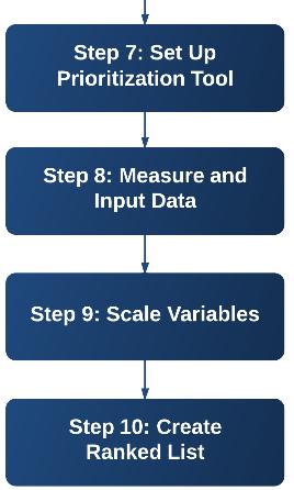
16 Phase I: Scoping Initial deliberation and preparation necessary to set up the prioritization process Phase II: Prioritization Process of calculating prioritization scores for each improvement location based on scoping in Phase I Photos by Robert Schneider
17 Improvement Locations Specific intersections, roadway segments, corridors or areas that are prioritized. Factors Categories used to express community/agency values and group variables with similar characteristics (e.g. equity, demand). Variables Characteristics of roadways, households, neighborhood areas, and other features that can be measured (e.g. population density, sidewalk presence). Weights Numbers used to indicate the relative importance of different factors based on community or agency values. Scaling Process of making variables comparable to one another (e.g. speed vs. ADT)
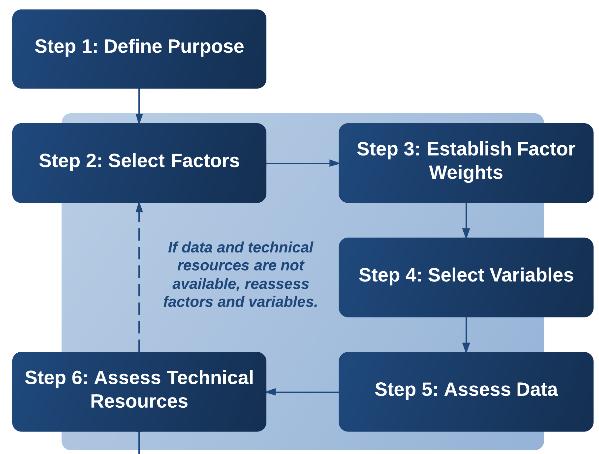
18


19 Mode Goals Improvement specific vs. general location Type/extent of improvement locations Number of improvement locations Photo by Michael Hintze


20 1. Stakeholder Input 2. Constraints 3. Opportunities 4. Safety 5. Existing Conditions 6. Demand 7. Connectivity 8. Equity 9. Compliance Photos by Robert Schneider
21 Prioritization Purpose Examples Stakeholder Input Constraints Opportunities Safety Existing Conditions Demand Connectivity Equity Compliance Segment Given a neighborhood where sidewalks are absent, select 30 segments to construct new sidewalks over the next three years Intersection/Crossing Given a regional trail with 50 unsignalized roadway crossings, identify 12 crossings for safety enhancements = Very relevant; = Less relevant; = Not likely relevant


22 Nine Factors Equally Weighted Four Factors Equally Weighted Relative impact of factors if weighted differently Nine Factors Factors 1 and 2 weighted more heavily Four Factors Factor 1 weighted more heavily
23 Set of possible variables is included for each factor category Possible variables came from: Literature review Agency survey Best practice guidance from organizations such as NCHRP, FHWA, AASHTO, NACTO, and ITE. Professional experience of research team
24 Variable Traffic speed in the parallel direction of travel or roadway being crossed Pedestrian Level of Service (LOS) (Segment) Pedestrian Level of Service (LOS) (Uncontrolled Crossing) Pedestrian Level of Service (LOS) (Signalized Intersection) FHWA Crosswalk Guidelines Pedestrian Intersection Safety Index (ISI) X X X X X Pedestrian Crash Modification Factors Traffic volume and composition (proportion heavy vehicles) in the parallel direction of travel or roadway being crossed X X X X Right turn on red restricted/allowed X X Signal timing (e.g., leading pedestrian interval, pedestrian clearance time, pedestrian and bicycle delay) X Presence/type of traffic control (e.g., traffic signal, stop sign) Presence of crosswalk warning signs or beacons (e.g., in street crossing signs, rectangular rapid flashing beacons, pedestrian hybrid beacon) Number of general purpose (through) lanes in the parallel direction of travel or being crossed X X X X X Note: Acomplete list of Existing Conditions variables is included in the APT Guidebook X X
25 Variable Maryland Meso Scale Model of Pedestrian Demand Charlotte, NC Signalized Intersection Pedestrian Volume Model Alameda County, CA Intersection Pedestrian Volume Model San Francisco Intersection Pedestrian Volume Model (1) Santa Monica, CA Pedestrian Volume Model San Diego, CA Pedestrian Volume Model Montreal, QC Signalized Intersection Pedestrian Volume Model Population or housing unit density X X X X X X Employment density X X X X X X Commercial retail property density/accessibility/proximity Transit station or stop density/accessibility/proximity Density/accessibility/proximity of attractors (grocery stores, restaurants, coffee shops, banks, parks, schools) X X X X X X X X X X X X Land use mix X X Note: Acomplete list of Demand variables is included in the APT Guidebook
26 Example Variables Relevance Potential Location Ped Bike Note: The relevance designations in this table are meant to provide general guidance. Ultimately, variable relevance depends on the prioritization purpose. Agencies are encouraged to review each variable and consider how relevant it may be considering their purpose. Appendix C provides references for the variables listed in this table to assist practitioners in finding additional information. = Very relevant = Less relevant = Not likely relevant S = Segment Cr = Crossing Co = Corridor A = Area Traffic speed 1 Cr, S, Co Traffic volume and composition (percentage of heavy vehicles) Cr, S, Co Right turning traffic volume Cr Type of traffic control (e.g., traffic signal, stop sign) Cr Presence of crosswalk warning signage or beacons Cr Width of outside through lane S, Co Presence and width of buffer between sidewalk and moving traffic S, Co Note: Acomplete list of Existing Conditions variables is included in the APT Guidebook
27 Inventory readily available data (e.g., roadway data, land use, traffic counts) Seek other data sources (if necessary) (e.g., regional, state or federal agency data, open data sources) Collect new data (if necessary) Generate data from GIS analysis (see Step 8) High level collection (e.g., using aerials, Street View imagery) Field verification/assessment Automatic (counters, video) Or don t use that variable if no data is available!
28 Example Demand Proxy Variables Population density Employment density Transit station or stop density/proximity/accessibility Socioeconomic characteristics (e.g., proportion of neighborhood residents living in poverty or without access to an automobile) Proximity to or number of bike share docking stations Data Considerations/Sources Population of given geography divided by its area, U.S. Census Employment is often compiled at the regional level and made available to local agencies by request from the Census Transportation Planning Package for traffic analysis zones. Density is calculated by dividing the number of employees by a measure of area. Longitudinal Employer Household Dynamics (LEHD) is another U.S. Census program that can provide employer/employee data estimates. Point data typically maintained by transit agency U.S. Census data (block group level data may be most appropriate for projecting demand). Note: This type of data may also be used for variables within the Equity factor. Point data layer of bike share stations
29 Inventory Data Source/Tool Can be used to inventory data for these variables Aerial Imagery Sidewalk and buffer presence and width Marked crosswalk presence and type Median island presence and width Bicycle facility presence and width Lane width/shoulder width Pedestrian crossing distance Street Level Imagery (e.g. video log, Street Curb ramp presence View) Truncated domes presence Pedestrian/bicycle related signage Major sidewalk obstructions Pedestrian signal heads Direct Field Observation (using technological data collection tools or manual observations) Pedestrian push buttons More precise lane width/shoulder width Traffic volume Traffic speed Sidewalk condition Crosswalk condition Pavement condition Curb ramp slope On street parking presence and occupancy

30 APT is intended to work for a range of technological capabilities GIS Example Source: Seattle Pedestrian Master Plan, 2009
31

32 Develop Demand Heat Map and Identify Corridors Prioritize Corridors and Separate into 3 Tiers Rank Improvements along Corridors Map by Lee Engineering
33 Calculating DEMAND Variable Source Schools City of Phoenix Bus Stops City of Phoenix City Facilities (e.g. libraries, municipal offices, etc.) City of Phoenix Community Centers City of Phoenix Light Rail Stops Valley Metro Park and Rides Valley Metro Parks City of Phoenix Existing Bikeways City of Phoenix Wikimap Routes Wikimap Wikimap Destinations Wikimap %ofhouseholdsinpoverty U.S. Census % of Population under 18 U.S. Census % Households with No Vehicle U.S. Census Population Density City of Phoenix
 within 1 mile of the corridor Secondary attractors (schools, city facilities, community")
34 Factor Weight Variable Source Number of times corridor intersects other corridors N/A Connectivity 10 Number times corridor intersects bicycle N/A facilities Presence of existing bicycle facilities City of Phoenix Demand 7 Stakeholder Input 3 Primary attractors (light rail stops, colleges/universities) within 1 mile of the corridor Secondary attractors (schools, city facilities, community centers, park and rides, parks) within ¼ mile of the corridor. Also includes bus stops directly on the corridor Land Use (commercial and high density housing) Population Density Valley Metro Google Maps City of Phoenix Valley Metro City of Phoenix City of Phoenix % Households in Poverty U.S. Census % Households with No Vehicle U.S. Census % of Population under 18 U.S. Census Bicycle Trip Origin and Destination Zip Codes from the Maricopa County Trip Reduction Survey Wikimap Destinations (included public meeting input and transit center surveys) Wikimap Routes (included public meeting input) Ad Hoc Task Force input Technical Advisory Committee input MAG Wikimap Wikimap Task Force TAC

35 Factor Variable Source Connectivity Bicycling Barriers Wikimap Existing Bikeways City of Phoenix Safety Bicycle Crashes MAG % of Population under 18 U.S. Census Existing Posted Speed Limit City of Phoenix Conditions Street Classification City of Phoenix Constraints Order of Magnitude Cost Lee Engineering Available Rights of Way City of Phoenix Demand Tier 1 Attractors (light rail stops, colleges/universities, schools) Valley Metro Google Maps Tier II Attractors (bus stops, bikeshare stations, city facilities, community centers, park and rides, parks) City of Phoenix Valley Metro Population Density Land Use (commercial and highdensity housing) Equity % Households in Poverty U.S. Census % Households with No Vehicle U.S. Census City of Phoenix Maricopa County

36 APT Guidebook Programmed Spreadsheet and User Guide GIS guidance Screencast Brochure NCHRP Final Report with research approach and findings
37 What do you want to do? Prioritize pedestrian or bicycle improvements for the first time Update /Compare an Existing Prioritization Process Identify areas most in need of investment for walking or biking (Planning Level Prioritization) Prioritize walking or biking investments at specific identified locations (Project Prioritization) How the APT can help Offers guidance for practitioners in local, regional, and state agencies that want to establish a prioritization process that is flexible, transparent, and incorporates agency/community values. Guides users through a logical sequence of steps and provides tips intended to save agencies time by facilitating important decisions around factor and variable selection; data collection, organization, and analysis; and tools and techniques for calculating prioritization scores. Provides research based guidance on additional factors and variables that may be used. Offers ideas for integrating data that is more qualitative into a quantitative framework. Suggests variables for identifying areas (e.g., corridors, neighborhoods, communities) for further analysis. Suggests variables for prioritizing specific project locations (e.g., intersections, roadway segments, corridors).
38 What do you want to do? Express community values in planning and project priorities How the APT can help Provides a method for incorporating variables based on community values and available data. Offers ideas for integrating data that is more qualitative into a quantitative framework. Engage stakeholders/public in prioritization process Establishes a transparent, data driven decision making process. Provides framework for integrating stakeholder/public input. Conduct funding decision prioritization Establishes a transparent, data driven funding decision making process. Communicates objective prioritization method and results to the public and other stakeholders. Prioritize list of Complete Streets projects to maximize benefits for walking or biking. Identifies variables that are applicable to both pedestrian and bicycle modes. Allows pedestrian and bicycle improvements to be prioritized separately and then combined to identify locations most in need of complete streets improvements.


39 Michael Hintze, AICP Toole Design Group, LLC Jim Elliott, AICP Toole Design Group, LLC Robert J. Schneider, PhD University of Wisconsin Milwaukee Department of Urban Planning
Overview of Report 803 Research Approach Case Studies Spreadsheet Tool Demo Question and Answer session. Photo by Michael Hintze
 Overview of Report 803 Research Approach Case Studies Spreadsheet Tool Demo Question and Answer session Photo by Michael Hintze NCHRP 07-17 Pedestrian and Bicycle Transportation along Existing Roads Project
Pedestrian Project List and Prioritization
 To: Kyle Wagenschutz, City of Memphis CC: From: Anne Conlon and John Cock, Alta Planning + Design Date: December, 2014 Re: Project List Development (Task 3.1-3.2) and Project List Prioritization (Task
The DC Pedestrian Master Plan
 The DC Pedestrian Master Plan September 28, 2010 George Branyan Pedestrian Program Coordinator District Department of Transportation Presentation Agenda Scope of the Plan Methodology Recommendations Implementation
GIS Based Data Collection / Network Planning On a City Scale. Healthy Communities Active Transportation Workshop, Cleveland, Ohio May 10, 2011
 The Purpose of GIS Based Network Planning GIS Based Data Collection / Network Planning Healthy Communities Active Transportation Conference Tuesday, May 10, 2011 10:00 AM Norman Cox, LLA, ASLA. Ann Arbor,
Pedestrian Safety and the Highway Safety Improvement Program
 Pedestrian Safety and the Highway Safety Improvement Program Karen Scurry, FHWA Office of Safety Kohinoor Kar, Arizona Department of Transportation David Cohen, FHWA California Division March 13, 2014
Regional Bicycle Barriers Study
 Regional Bicycle Barriers Study Executive Summary Background and Purpose The 2040 Transportation Policy Plan (TPP) sets policies for planning and investment direction in the transportation system in the
PBIC Webinar. How to Create a Bicycle Safety Action Plan: Planning for Safety [IMAGE] Oct. 2, 2014, 2 pm
![PBIC Webinar. How to Create a Bicycle Safety Action Plan: Planning for Safety [IMAGE] Oct. 2, 2014, 2 pm](/thumbs/86/93953441.jpg "PBIC Webinar. How to Create a Bicycle Safety Action Plan: Planning for Safety [IMAGE] Oct. 2, 2014, 2 pm") PBIC Webinar How to Create a Bicycle Safety Action Plan: Planning for Safety [IMAGE] Bill Schultheiss, Vice President, Toole Design Peter Lagerwey, Regional Director, Toole Design Oct. 2, 2014, 2 pm Today
PBIC Webinar How to Create a Bicycle Safety Action Plan: Planning for Safety [IMAGE] Bill Schultheiss, Vice President, Toole Design Peter Lagerwey, Regional Director, Toole Design Oct. 2, 2014, 2 pm Today
Bridgewater Complete Streets Prioritization Plan and Pedestrian Safety Assessment
 Bridgewater Complete Streets Prioritization Plan and Pedestrian Safety Assessment Presented by Luciano Rabito Manager of Complete Streets Presented to Bridgewater, MA Wednesday, April 26, 2017 6:30 P.M.
Agenda. Overview PRINCE GEORGE S PLAZA METRO AREA PEDESTRIAN PLAN
 PRINCE GEORGE S PLAZA METRO AREA PEDESTRIAN PLAN May 28, 2008 Agenda Welcome and introductions Project overview and issue identification Planning context and strengths Design challenges and initial recommendations
APPENDIX A: Complete Streets Checklist DRAFT NOVEMBER 2016
 APPENDIX A: Complete Streets Checklist DRAFT NOVEMBER 2016 Complete Streets Checklist MetroPlan Orlando s Complete Streets Checklist is an internal planning tool for staff to further implementation of
Development of Arlington County s Marked Crosswalk Guidelines. Jon Lawler, P.E. Design Engineer Arlington County, VA
 Development of Arlington County s Marked Crosswalk Guidelines Jon Lawler, P.E. Design Engineer Arlington County, VA April 13, 2015 Transportation System Users Residents Estimated 215,000 in 2014 Lowest
I-105 Corridor Sustainability Study (CSS)
") I-105 Corridor Sustainability Study (CSS) Metro Streets and Freeways Subcommittee March 21, 2019 Gary Hamrick Cambridge Systematics, Inc. I-105 CSS Project History & Background Funded by Caltrans Sustainable
I-105 Corridor Sustainability Study (CSS) Metro Streets and Freeways Subcommittee March 21, 2019 Gary Hamrick Cambridge Systematics, Inc. I-105 CSS Project History & Background Funded by Caltrans Sustainable
GIS Based Non-Motorized Transportation Planning APA Ohio Statewide Planning Conference. GIS Assisted Non-Motorized Transportation Planning
 The Purpose of GIS Assisted Network GIS Assisted Non-Motorized Transportation 2011 APA Ohio Statewide Conference Friday, 10:45 AM to Noon Focus on near-term projects wwwgreenwaycollabcom The purpose of
Hennepin County Pedestrian Plan Public Comment Report
 Hennepin County Pedestrian Plan Public Comment Report On May 31, 2013, the draft Hennepin County Pedestrian Plan was released for a 45-day public comment period ending July 15, 2013. The county received
Multimodal Analysis in the 2010 Highway Capacity Manual
 Multimodal Analysis in the 2010 Highway Capacity Manual It s not just cars anymore! Jamie Parks, AICP HCAT Conference May 9-10, 2011 Multimodal LOS in the 2010 HCM History and background Overview of methods
Pedestrian Safety at Interchanges
 Countermeasure Strategies for Pedestrian Safety Pedestrian Safety at Interchanges Meghan Mitman Fehr and Peers December 10, 2015 Today s Presentation Introduction and housekeeping Audio issues? Dial into
Defining Purpose and Need
 Advanced Design Flexibility Pilot Workshop Session 4 Jack Broz, PE, HR Green May 5-6, 2010 Defining Purpose and Need In your agency s project development process, when do design engineers typically get
WALKNBIKE DRAFT PLAN NASHVILLE, TENNESSEE EXECUTIVE SUMMARY NASHVILLE, TENNESSEE
 NASHVILLE, TENNESSEE EXECUTIVE SUMMARY Executive Summary A world-class multi-modal transportation system is essential to a vibrant city and better quality of life. -Mayor Barry The WalknBike plan aims
Road Diets: Improving Safety for All Road Users
 Road Diets: Improving Safety for All Road Users Tamara Redmon, Federal Highway Administration Brian Chandler, Leidos Keith Knapp, Iowa Local Technical Assistance Program March 3, 2015 Today s Presentation
ADOT Statewide Bicycle and Pedestrian Program Summary of Phase IV Activities APPENDIX B PEDESTRIAN DEMAND INDEX
 ADOT Statewide Bicycle and Pedestrian Program Summary of Activities APPENDIX B PEDESTRIAN DEMAND INDEX May 24, 2009 Pedestrian Demand Index for State Highway Facilities Revised: May 29, 2007 Introduction
Bike Planning: A New Day
 Bike Planning: A New Day Josh Sikich, AICP, LEED AP Chicago Office Director Alta Planning + Design 312-265-0628 joshuasikich@altaplanning.com cities of all sizes are changing Illinois Bike Summit October
PEDESTRIAN SAFETY IMPROVEMENT EVALUATION GUIDELINE FOR UNCONTROLLED CROSSINGS
 PEDESTRIAN SAFETY IMPROVEMENT EVALUATION GUIDELINE FOR UNCONTROLLED CROSSINGS Traffic Safety Engineering Division Updated: April 2018 EXECUTIVE SUMMARY NDOT Traffic Safety Engineering Division developed
FHWA Bikeway Selection Guide
 FHWA Bikeway Selection Guide Tamara Redmon Federal Highway Administration Bill Schultheiss Toole Design Lauren Blackburn VHB March 26, 2019 PBIC Webinar pedbikeinfo.org @pedbikeinfo Housekeeping Problems
Pedestrian Safety at Roundabouts
 Countermeasure Strategies for Pedestrian Safety Pedestrian Safety at Roundabouts Hillary Isebrands Federal Highway Administration January 6, 2016 Today s Presentation Introduction and housekeeping Audio
Comprehensive Bicycle Master Plan 2014 ITE-IMSA Spring Conference March 6, 2014
 Comprehensive Bicycle Master Plan 2014 ITE-IMSA Spring Conference March 6, 2014 Street Transportation Department Inventory of Bikeways (October 7, 2013) 22 bike bridges 20 bike tunnels 420 miles of bike
NJDOT Complete Streets Checklist
 Background The New Jersey Department of Transportation s Complete Streets Policy promotes a comprehensive, integrated, connected multi-modal network by providing connections to bicycling and walking trip
2010 Pedestrian and Bicyclist Special Districts Study Update
 2010 Pedestrian and Bicyclist Special Districts Study Update Pedestrian and Bicyclist Special Districts Program Overview H-GAC s Special Districts Program aims to provide strategic investments in pedestrian
MASTER BICYCLE AND PEDESTRIAN PLAN
 WELCOME! PLEASE FEEL FREE TO REVIEW THE EXHIBITS THE PRESENTATION WILL BEGIN AT 6:00 PM VILLAGE OF NORTHBROOK MASTER BICYCLE AND PEDESTRIAN PLAN DRAFT EXISTING CONDITIONS REPORT AND PUBLIC MEETING WELCOME!
STEP. Proactively Addressing Crash Risk with Systemic Safety Analysis. Safe Transportation for Every Pedestrian
 STEP Safe Transportation for Every Pedestrian Proactively Addressing Crash Risk with Systemic Safety Analysis Rebecca Sanders, Toole Design Chris Svolopoulos, Seattle Department of Transportation Offer
REGIONAL BICYCLE AND PEDESTRIAN DESIGN GUIDELINES
 REGIONAL BICYCLE AND PEDESTRIAN DESIGN GUIDELINES November 16, 2011 Deb Humphreys North Central Texas Council of Governments Bicycle and Pedestrian Advisory Committee Snapshot of the Guide 1. Introduction
Chapter 2. Bellingham Bicycle Master Plan Chapter 2: Policies and Actions
 Chapter 2 Bellingham Bicycle Master Plan Chapter 2: Policies and Actions Chapter 2: Policies and Actions The Bicycle Master Plan provides a road map for making bicycling in Bellingham a viable transportation
RURAL HIGHWAY SHOULDERS THAT ACCOMMODATE BICYCLE AND PEDESTRIAN USE (TxDOT Project ) June 7, Presented by: Karen Dixon, Ph.D., P.E.
 June 7, Presented by: Karen Dixon, Ph.D., P.E.") RURAL HIGHWAY SHOULDERS THAT ACCOMMODATE BICYCLE AND PEDESTRIAN USE (TxDOT Project 0-6840) June 7, 2016 Presented by: Karen Dixon, Ph.D., P.E., TTI Team: Kay Fitzpatrick, Raul Avelar, & Subasish Das Project
RURAL HIGHWAY SHOULDERS THAT ACCOMMODATE BICYCLE AND PEDESTRIAN USE (TxDOT Project 0-6840) June 7, 2016 Presented by: Karen Dixon, Ph.D., P.E., TTI Team: Kay Fitzpatrick, Raul Avelar, & Subasish Das Project
Bicycle and Pedestrian Planning in a Historically Car-Centric Culture: A Focus on Connectivity, Safety, & Accessibility
 Bicycle and Pedestrian Planning in a Historically Car-Centric Culture: A Focus on Connectivity, Safety, & Accessibility Kate Horton and Zylavian Watley Transportation Planners Memphis MPO Date: October
PRINCE GEORGE S PLAZA METRO AREA PEDESTRIAN PLAN
 PRINCE GEORGE S PLAZA METRO AREA PEDESTRIAN PLAN May 28, 2008 Agenda Welcome and introductions Project overview and issue identification Planning context and strengths Design challenges and initial recommendations
Bicycle Safety Guide and Countermeasure Selection System (BIKESAFE) Webinar
 Webinar") PBIC Webinar Bicycle Safety Guide and Countermeasure Selection System (BIKESAFE) Webinar [IMAGE] Tamara Redmon, FHWA Office of Safety Carl Sundstrom, UNC Highway Safety Research Center Dan Nabors, Vanasse
PBIC Webinar Bicycle Safety Guide and Countermeasure Selection System (BIKESAFE) Webinar [IMAGE] Tamara Redmon, FHWA Office of Safety Carl Sundstrom, UNC Highway Safety Research Center Dan Nabors, Vanasse
FHWA Resources for Pedestrian and Bicycle Professionals
 FHWA Resources for Pedestrian and Bicycle Professionals Charlie Zegeer, UNC Highway Safety Research Center/PBIC Libby Thomas, UNC Highway Safety Research Center Dan Nabors, Vanasse Hangen Brustlin (VHB)
IMPROVING PEDESTRIAN SAFETY AT UNCONTROLLED CROSSINGS. Guidelines for Marked Crosswalks
 IMPROVING PEDESTRIAN SAFETY AT UNCONTROLLED CROSSINGS Presented by Nazir Lalani P.E. Traffex Engineers Inc. N_lalani@hotmail.com Guidelines for Marked Crosswalks Source: FHWA, Safety Effects of Marked
Citywide Sidewalk and Crosswalk Programs
 Citywide Sidewalk and Crosswalk Programs Council Meeting October 20, 2015 Presented by Rita Hu and Jamal Mahmoud Program Goals Implement the City s comprehensive plan. Provide pedestrian with safe walking
Update on Regional Bicycle, Pedestrian, & Trail Planning. Presented to TCC November 21, 2014
 Update on Regional Bicycle, Pedestrian, & Trail Planning Presented to TCC November 21, 2014 Survey Measure Assess Focus Area Performance- Driven Process Policy Policy Implement Plan Criteria Criteria Criteria
Multimodal Design Guidance. October 23, 2018 ITE Fall Meeting
 Multimodal Design Guidance October 23, 2018 ITE Fall Meeting Introductions Jessica Wilson TDOT Multimodal Division Office of Multimodal Planning Program Supervisor Jessica.L.Wilson@tn.gov Ali Hangul TDOT
UNCONTROLLED PEDESTRIAN CROSSING GUIDELINES
 City and County of Denver UNCONTROLLED PEDESTRIAN CROSSING GUIDELINES Prepared for: Prepared by: Adopted September 2016 This page is intentionally left blank. Contents for Denver Uncontrolled Pedestrian
Pedestrian, Bicycle and Traffic Calming Strategic Implementation Plan. January 18, 2011
 Pedestrian, Bicycle and Traffic Calming Strategic Implementation Plan January 18, 2011 Tonight s Agenda Receive update on project Provide feedback on two policy issues Complete Streets Policy Project Prioritization
San Jose Transportation Policy
 San Jose Transportation Policy Protected Intersections in LOS Policies to Support Smart Growth Presented by: Manuel Pineda City of San Jose Department of Transportation Bay Area Map San Francisco Oakland
Designing for Pedestrian Safety in Washington, DC
 Designing for Pedestrian Safety in Washington, DC February 25, 2014 George Branyan Pedestrian Program Coordinator District Department of Transportation DC Journey to work mode split: 2012 Means of Transportation
BIKE PLAN CONTENTS GATEWAY
 CONTENTS Acknowledgments...vii Great Rivers Greenway District Board of Directors... vii Great Rivers Greenway District Staff... vii Project Consultants... vii Committees... viii Citizens Advisory Committee
EXECUTIVE SUMMARY... vii 1 STUDY OVERVIEW Study Scope Study Area Study Objectives
 Contents EXECUTIVE SUMMARY... vii 1 STUDY OVERVIEW... 1-1 1.1 Study Scope... 1-1 1.2 Study Area... 1-1 1.3 Study Objectives... 1-3 2 EXISTING CONDITIONS... 2-1 2.1 Existing Freeway Conditions... 2-4 2.1.1
City of Jacksonville Mobility Fee Update
 City of Jacksonville Mobility Fee Update 2017 Preliminary Analysis May 3, 2017 Carnival Cruise lines photo credit Presentation Overview Public Outreach Process Pedestrian and Bicycle Master Plan Study
Bicycle and Pedestrian Chapter TPP Update Overview. TAB September 20, 2017
 Bicycle and Pedestrian Chapter TPP Update Overview TAB September 20, 2017 Bicycling & Walking in the Twin Cities Where are we now? The Bike-Pedestrian system Current trends New developments Where are we
PBIC Webinar. Integrating Ped/Bike Concepts into University Courses: New Materials and Noteworthy Practices [IMAGE] August 19, 2015, 1 pm
![PBIC Webinar. Integrating Ped/Bike Concepts into University Courses: New Materials and Noteworthy Practices [IMAGE] August 19, 2015, 1 pm](/thumbs/89/98142053.jpg "PBIC Webinar. Integrating Ped/Bike Concepts into University Courses: New Materials and Noteworthy Practices [IMAGE] August 19, 2015, 1 pm") PBIC Webinar Integrating Ped/Bike Concepts into University Courses: New Materials and Noteworthy Practices [IMAGE] Mike Flynn, Sam Schwartz Engineering Jeff LaMondia, Auburn University Kari Edison Watkins,
PBIC Webinar Integrating Ped/Bike Concepts into University Courses: New Materials and Noteworthy Practices [IMAGE] Mike Flynn, Sam Schwartz Engineering Jeff LaMondia, Auburn University Kari Edison Watkins,
MassDOT s Transportation Choice and Healthy Transportation Policy Initiatives
 MassDOT s Transportation Choice and Healthy Transportation Policy Initiatives Jackie DeWolfe, Director of Sustainable Mobility, MassDOT Michelle Danila, Complete Streets Engineer, MassDOT ACEC April 2018
Omaha s Complete Streets Policy
 Omaha s Complete Streets Policy (Adopted August 2015) VISION To create great places and enhance our quality of life, the City of Omaha will provide safe, accessible streets for all users. Complete Streets
POTENTIAL PEDESTRIAN SAFETY IMPROVEMENT EVALUATION GUIDELINE
 POTENTIAL PEDESTRIAN SAFETY IMPROVEMENT EVALUATION GUIDELINE Traffic Safety Engineering Division Updated: August 2016 EXECUTIVE SUMMARY During the February 2015 Transportation Board meeting, Governor Brian
PBIC Webinar. Improving Multimodal Outcomes through Performance Measurement and Design Flexibility. November 14, 2016
 PBIC Webinar Improving Multimodal Outcomes through Performance Measurement and Design Flexibility Dan Goodman, Federal Highway Administration Michelle Danila, Toole Design Group Conor Semler, Kittelson
TODAY S WEBINAR AGENDA
 TODAY S WEBINAR AGENDA 3:00 pm: Introduction 3:05 pm: Presentation 3:45 pm: Questions 4:00 pm: Webinar Ends For technical assistance during the webinar: 1-800-263-6317 Choose these prompts: 1, 1, 1 CONTINUING
Complete Street Analysis of a Road Diet: Orange Grove Boulevard, Pasadena, CA
 Complete Street Analysis of a Road Diet: Orange Grove Boulevard, Pasadena, CA Aaron Elias, Bill Cisco Abstract As part of evaluating the feasibility of a road diet on Orange Grove Boulevard in Pasadena,
Statewide Pedestrian and Bicycle Transportation Plan and Economic Impact Study. Kick off Meeting November 28, Your Planning Team
 Statewide Pedestrian and Bicycle Transportation Plan and Economic Impact Study Kick off Meeting November 28, 2018 Your Team Alta + Design Statewide planning efforts in 18 states Bike/ped network planning
Who is Toole Design Group?
 2018 AASHTO Bike Guide Status Update NCHRP 15 60 Amalia Leighton Cody, PE, AICP & Kenneth Loen, PE Washington APWA October 4, 2018 Who is Toole Design Group? TDG is a full service engineering, planning
Watertown Complete Streets Prioritization Plan. Public Meeting #1 December 14, 2017
 Watertown Complete Streets Prioritization Plan Public Meeting #1 December 14, 2017 Goals for Public Meeting Overview of MassDOT Complete Streets Funding Program Educate the community on Complete Streets
San Francisco Streetscape Prioritization. Best Practices Review. November 2014
 November 2014 29 Table of Contents Executive Summary... ES-1 Introduction... 1 Case Study Prioritization Methodologies... 1 Charlotte Sidewalk Retrofit Program... 1 Portland Safe Routes to School... 2
Making Signals Work for Bicyclists and Pedestrians
 Making Signals Work for Bicyclists and Pedestrians Peter Koonce, PE Portland, OR October 18, 2017 PBIC Webinar pedbikeinfo.org @pedbikeinfo Housekeeping Problems with audio? Dial into the phone line instead
2. Vision & Goals. Vision. Santa Rosa is a community where walking and bicycling are comfortable and convenient for people of all ages and abilities.
 2. Vision & Goals Overview The goals of the Santa Rosa Bicycle and Pedestrian Master Plan Update reflect the priorities expressed by the community throughout the public outreach phase of this Plan Update.
Safety & Convenience for All Users, in All Modes. Barbara McCann NCSL December 3, 2013
 Safety & Convenience for All Users, in All Modes Barbara McCann NCSL December 3, 2013 Safety & Convenience for All Users? Who was left out when this road was planned? Takaaki Iwabu for Raleigh News Observer
2014 Regional Bicycle and Pedestrian Study Evaluation Tools Leslie A. Meehan, AICP MPO Technical Coordinating Committee Meeting April 1, 2015
 Mayor Mayor Kenneth Karl Dean, Wilber, Chairman 2014 Regional Bicycle and Pedestrian Study Evaluation Tools Leslie A. Meehan, AICP MPO Technical Coordinating Committee Meeting April 1, 2015 Evaluation
MAG Town of Cave Creek Bike Study Task 6 Executive Summary and Regional Significance Report
 Page 1 MAG Town of Cave Creek Bike Study Task 6 Executive Summary and Regional Significance Report August 1, 2012 MAG Project #481 Page 2 Task 6 Executive Summary and Regional Significance Report Introduction
USDOT Bicycle and Pedestrian Safety Initiative: Safer People and Safer Streets. Barbara McCann, USDOT Office of Policy
 { USDOT Bicycle and Pedestrian Safety Initiative: Safer People and Safer Streets Barbara McCann, USDOT Office of Policy 4 Steps from policy to practice Creating multi-modal streets means: 1. Change Decision-Making
Planning Guidance in the 2012 AASHTO Bike Guide
 Planning Guidance in the 2012 AASHTO Bike Guide Presentation by: RJ Eldridge Peter Lagerwey August 22, 2012 WEBINAR 2: PLANNING GUIDANCE IN THE 2012 AASHTO BIKE GUIDE Today s Webinar Significant Updates
AMATS Complete Streets Policy
 AMATS Complete Streets Policy Table of Contents: Section 1. Definition of Complete Streets Section 2. Principles of Complete Streets Section 3. Complete Streets Policy Section 4. Consistency Section 5.
Evolving Roadway Design Policies for Walking and Bicycling
 Evolving Roadway Design Policies for Walking and Bicycling The 2016 Michigan Transportation Planning Conference Kalamazoo, MI July 13, 2016 Title 23 of the Code of Federal Regulations Title 23 was originally
TOWN OF PORTLAND, CONNECTICUT COMPLETE STREETS POLICY
 TOWN OF PORTLAND, CONNECTICUT COMPLETE STREETS POLICY I. VISION, GOALS & PRINCIPLES VISION To improve the streets of Portland making them safer and more accessible for all users including pedestrians,
Strategic Plan for Active Mobility Phase I: Bicycle Mobility
 Strategic Plan for Active Mobility Phase I: Bicycle Mobility City of Corpus Christi February 9, 2016 Jeff Pollack, AICP Transportation Planning Director Vision Active Mobility Plan Vision The metropolitan
Broad Street Bicycle Boulevard Design Guidelines
 Broad Street Bicycle Boulevard Design Guidelines Building from the strategies introduced in the 2013 Bicycle Transportation Plan and community input received thus far, City Transportation Staff have identified
MOBILITY WORKSHOP. Joint City Council and Transportation Commission May 5, 2014
 MOBILITY WORKSHOP Joint City Council and Transportation Commission May 5, 2014 Review of General Plan M-1 Develop world-class transit system M-3 Maintain/enhance pedestrian-oriented City M-4 Create comprehensive
Bicycle and Pedestrian Connectivity Study. Old Colony Planning Council
 Bicycle and Pedestrian Connectivity Study Old Colony Planning Council Outline Why consider bike/peds in road designs? Why are measures needed? Connecting Land Use with Transportation Evaluation Tools:
PEDESTRIAN CROSSING TREATMENTS
 PEDESTRIAN CROSSING TREATMENTS BEST PRACTICES Presented by: Doug Enderson, P.E., PTOE Cody Salo, P.E. 1 PRESENTER INTRODUCTIONS Doug Enderson, P.E., PTOE Ped Crossing Experience: ADA Design-Build ADA Inventory
Proposed. City of Grand Junction Complete Streets Policy. Exhibit 10
 Proposed City of Grand Junction Complete Streets Policy Exhibit 10 1 City of Grand Junction Complete Streets Policy Vision: The Complete Streets Vision is to develop a safe, efficient, and reliable travel
Urbana Pedestrian Master Plan
 Urbana Pedestrian Master Plan Recommendations Gabe Lewis, Transportation Planner Champaign County Regional Planning Commission November 15, 2018 Public Meeting #2 Public Input Round #1 Thank You! 10 public
CHAPTER 3: Vision Statement and Goals
 Davidson Walks & Rolls: Active Transportation Master Plan CHAPTER 3 Contents: Overview Vision Statement Measurable Goals Public Outreach CHAPTER 3: Vision Statement and Goals Overview The vision statement
APRIL 1, 2015 APWA CONFERENCE. TIM HANSEN, PE Chief Operating Officer AHBL, Inc. Project Designer
 DIANE WIATR Active Transportation Coordinator/Senior Planner City of Tacoma APRIL 1, 2015 APWA CONFERENCE TIM HANSEN, PE Chief Operating Officer AHBL, Inc. Project Designer MATT PAVOLKA Project Manager
Active Transportation Facility Glossary
 Active Transportation Facility Glossary This document defines different active transportation facilities and suggests appropriate corridor types. Click on a facility type to jump to its definition. Bike
Bicycle Master Plan Goals, Strategies, and Policies
 Bicycle Master Plan Goals, Strategies, and Policies Mobilizing 5 This chapter outlines the overarching goals, action statements, and action items Long Beach will take in order to achieve its vision of
A Matter of Fairness: ROCOG s Environmental Justice Protocol. What is Mobility Limitation?
 No Person Left Behind What is Mobility Limitation? What is the Access Limitation? Environmental Justice population should be provided adequate mobility & access to meet their needs; Identify acceptable
Chapter 14 PARLIER RELATIONSHIP TO CITY PLANS AND POLICIES. Recommendations to Improve Pedestrian Safety in the City of Parlier (2014)
") Chapter 14 PARLIER This chapter describes the current status and future plans for biking and walking in the City of Parlier. RELATIONSHIP TO CITY PLANS AND POLICIES The Parlier General Plan is the primary
Chapter 14 PARLIER This chapter describes the current status and future plans for biking and walking in the City of Parlier. RELATIONSHIP TO CITY PLANS AND POLICIES The Parlier General Plan is the primary
Methodology for Linking Greenways and Trails with Public Transportation in Florida
 Methodology for Linking Greenways and Trails with Public Transportation in Florida Sara Hendricks, Senior Research Associate Center for Urban Transportation Research, University of South Florida CUTR Webcast,
Community Task Force March 14, 2018
 Community Task Force March 14, 2018 Welcome and Introductions Project Partners Regional Transportation District (RTD) City of Aurora Colorado Department of Transportation (CDOT) Denver Regional Council
Anne Arundel County BICYCLE, PEDESTRIAN, TRANSIT ASSESSMENT GUIDELINES
 Anne Arundel County BICYCLE, PEDESTRIAN, TRANSIT ASSESSMENT GUIDELINES December 2018 TABLE OF CONTENTS I. Executive Summary 3 II. When Is A Bicycle Pedestrian Transit Assessment (BPTA) Required? 4 III.
BICYCLE FACILITIES INVENTORY: SUMMARY REPORT
 BICYCLE FACILITIES INVENTORY: SUMMARY REPORT Southern New Jersey September 2008 2002 D Lincoln Drive West Marlton, NJ 08053 (856) 596-8228 www.driveless.com BICYCLE FACILITIES INVENTORY SUMMARY REPORT
Countermeasure Strategies for Pedestrian Safety. Road Diets. Matthew Ridgway Fehr and Peers. October 6, 2015
 Countermeasure Strategies for Pedestrian Safety Road Diets Matthew Ridgway Fehr and Peers October 6, 2015 Today s Presentation Introduction and housekeeping Audio issues? Dial into the phone line instead
Crossing Islands and Raised Medians
 Countermeasure Strategies for Pedestrian Safety Crossing Islands and Raised Medians Demian Miller Tindale Oliver and Associates October 1, 2015 Today s Presentation Introduction and housekeeping Audio
US 41 COMPLETE STREETS CORRIDOR PLANNING STUDY from University Parkway to Whitfield Avenue
 41 US 41 COMPLETE STREETS CORRIDOR PLANNING STUDY from University Parkway to Whitfield Avenue EXECUTIVE SUMMARY DRAFT FEBRUARY 2019 Project Overview The US 41 Complete Streets Corridor Planning Study,
Bicycle RSAs: How to Conduct Road Safety Audits and How to Use Them to Promote Bicyclist Safety. Dan Nabors, PE, VHB Bill DeSantis, PE, VHB
 PBIC Webinar Bicycle RSAs: How to Conduct Road Safety Audits and How to Use Them to Promote Bicyclist Safety [IMAGE] Dan Nabors, PE, VHB Bill DeSantis, PE, VHB Sept. 26, 2013, 2 pm Today s Presentation
STEP. Rectangular Rapid Flashing Beacons. Safe Transportation for Every Pedestrian
 STEP Safe Transportation for Every Pedestrian Rectangular Rapid Flashing Beacons Duane Thomas, Federal Highway Administration Megan McCarty Graham, Toole Design October 30, 2018 Housekeeping Problems with
Overview. Illinois Bike Summit IDOT Complete Streets Policy Presentation. What is a Complete Street? And why build them? And why build them?
 Overview Illinois Bike Summit IDOT Complete Streets Policy Presentation Aren Kriks, P.E. District One Bicycle Coordinator and Bureau of Programming Project Engineer History of Complete Streets IDOT Policy
Transit-Driven Complete Streets
 Questions: Type questions into the box at bottom of webinar panel. Panelists for today s webinar: Nimotalai Azeez, Program Associate with the National Complete Streets Coalition Rich Weaver, Director of
TABLE OF CONTENTS. Executive Summary
 Executive Summary Background... ES-1 Pedestrian Network... ES-2 Bikeway Network... ES-2 Collision History... ES-2 Public Input... ES-4 Conclusions and Recommendations... ES-4 1. Introduction and Setting
San Mateo County Comprehensive Bicycle and Pedestrian Plan Open House
 San Mateo County Comprehensive Bicycle and Pedestrian Plan Open House October 28, 2010 Presented to San Mateo County residents and interested parties by Lauren Ledbetter, Alta Planning + Design Matt Haynes,
Making Great Urban Streets Confessions of a Highway Engineer. Timothy R. Neuman.. P.E. Chief Highway Engineer CH2M HILL
 Making Great Urban Streets Confessions of a Highway Engineer Timothy R. Neuman.. P.E. Chief Highway Engineer CH2M HILL Isn t this a Great Street? Characteristics of a Great Street It is a transportation
TULSA CITY COUNCIL CAPITAL IMPROVEMENT PROGRAM TASK FORCE MEETING JANUARY
 CITY OF TULSA BICYCLE & PEDESTRIAN INFRASTRUCTURE TULSA CITY COUNCIL CAPITAL IMPROVEMENT PROGRAM TASK FORCE MEETING JANUARY 31, 2013 CITY OF TULSA ENGINEERING SERVICES DEPARTMENT CITY OF TULSA ADA TRANSITION
Presentation Summary Why Use GIS for Ped Planning? What Tools are Most Useful? How Can They be Applied? Pedestrian GIS Tools What are they good for?
 1 2 Pedestrian GIS Tools What are they good for? Pro Walk / Pro Bike 2006 Presentation Summary Why Use GIS for Ped Planning? What Tools are Most Useful? How Can They be Applied? Matt Haynes Fehr & Peers
Minutes of June 18-19, 2007 AASHTO Technical Committee on Nonmotorized Transportation (TCNT) in Lake Tahoe, NV
 in Lake Tahoe, NV") Minutes of June 18-19, 2007 AASHTO Technical Committee on Nonmotorized Transportation (TCNT) in Lake Tahoe, NV Note: The TCNT met in conjunction with the meeting of the AASHTO Standing Committee on Traffic
Minutes of June 18-19, 2007 AASHTO Technical Committee on Nonmotorized Transportation (TCNT) in Lake Tahoe, NV Note: The TCNT met in conjunction with the meeting of the AASHTO Standing Committee on Traffic
92% COMMUTING IN THE METRO. Congested Roadways Mode Share. Roadway Congestion & Mode Share
 COMMUTING IN THE METRO Roadway Congestion & Mode Share The majority of major roadways in Greater Des Moines are without congestion and have underutilized capacity. This surplus capacity could be used for