Bridgewater Complete Streets Prioritization Plan and Pedestrian Safety Assessment
|
|
|
- Leslie Daniel
- 6 years ago
- Views:
Transcription


1 Bridgewater Complete Streets Prioritization Plan and Pedestrian Safety Assessment Presented by Luciano Rabito Manager of Complete Streets Presented to Bridgewater, MA Wednesday, April 26, :30 P.M.


2 What is a Complete Street? Complete Streets defined: A Complete Street is one that provides safe and accessible options for all travel modes walking, biking, transit, and vehicles for people of all ages and abilities Complete Streets improvements may be large scale such as corridor wide improvements or focused on the needs of a single mode at a single location Amherst Route 116 Mt. Holyoke Visitor Center Bus Stop Greenfield Greenfield Community College Roundabout

 Road diets 8 49% (ITE) Countdown")
3 PLANNING/PRIORITIZATION Safety Benefits of Complete Streets Interventions to reduce pedestrian crashes: Sidewalks Shoulders 88% (FHWA) 71% (FDOT) Interventions to reduce crashes: Medians 40% (NCHRP) Road diets 8 49% (ITE) Countdown signals 25% (FHWA)
 Complete Streets feature curb cuts, high")
4 PLANNING/PRIORITIZATION ADA Benefits of Complete Streets 18.7% of Americans have some type of disability that limits mobility (including physical, visual, and hearing impairments) Complete Streets feature curb cuts, high visibility crosswalks, and other designs for travelers with disabilities Complete Streets reduce isolation and dependence
5 PLANNING/PRIORITIZATION Economic Benefits of Complete Streets Investment in a community s walkability typically increases land value % Above-average Neighborhood Walk Score translates into improved local economy About $4,000-$34,000 higher real estate Retail sales increase by 30 About $4,000 - $34,000 higher real estate sales prices by 30% ~ Healthier Communities Through Design, American Institute of Architects (AIA)

6 PLANNING/PRIORITIZATION Transit, Equity and Health Benefits of Complete Streets Low to moderate income households spend a greater percentage of income on public transportation Environmental justice households are less likely to own a vehicle; those with disabilities, children and the elderly may not be able to drive Car-centric communities limit opportunities for daily physical activity Complete Streets provide: Improved public transportation options More options for transportation Allowing all types of users to: Minimize travel costs Increase daily exercise Safely reach more destinations and opportunities


7 Complete Streets Funding Program History Program was released February 2, 2016 For FY 16 and FY 17, there was $12.5M of funding available from Casino Funds The MassDOT Capital Investment Plan (CIP) provides funding for this program over the next five years set at $50 million 121 municipalities have passed Complete Streets Policies that scored 80 or above, and 53 have submitted Prioritization Plans

 50 Municipalities given")
8 PROGRAM/FUNDING Funding to Date Tier 3 Project Funding (Round 1: FY 2017) 11 Projects totaling $4.4M Tier 3 Project Funding (Round 2: FY 2017) 15 Projects totaling $5.5M Tier 2 Prioritization Plan Funds (FY 2017) 50 Municipalities given Technical Assistance for their Prioritization Plans, totaling $2.6M
9 CS Funding Program Snapshot Three Tiers for entry into the Program Planning Assistance to support CS Prioritization Plan up to $50,000 available to any community (Reimbursable) CS Construction up to $400,000 (Reimbursable) Eligible list of CS infrastructure and roadways. Design is not an eligible expense $12.5M to be spent over the next two years ( ) Beyond FY17, there is a proposed $50M over 5 Years in the CIP
10 CS Funding Program Framework Tier 1 Training and Complete Streets Policy Development Tier 2 Complete Streets Prioritization Plan Development Tier 3 Project Approval and Notice to Proceed for Construction

11 Prioritization Plan Process Compile existing studies, plans, projects, etc. Map areas of concern and areas of potential Gather input from the community and from Town officials Work with Town to identify a list of potential projects Prioritize projects based on potential, need, input from community, and Town officials priorities

12 HSH PRIORITIZATION PROCESS Potential Pedestrian Utility Walking to Points of Interest


13 HSH PRIORITIZATION PROCESS Pedestrian Level of Comfort Shows quality of existing sidewalks and gaps in the sidewalk network Criteria considered include: Pavement quality Sidewalk width and pinch points Vertical or horizontal buffers Grade separation Continuity Potential vehicle/ pedestrian conflict Vegetation Land use Road speed and traffic volumes West Springfield, MA

14 HSH PRIORITIZATION PROCESS Bicycle Level of Comfort
15 HSH PRIORITIZATION PROCESS Bicycle Level of Comfort Local roads and trails are comfortable for novice-level cyclists High speed or high volume roads are low comfort expect for strong and fearless riders Criteria considered include: Road speed and traffic volumes Number of lanes Type of existing bicycle facilities Intersection characteristics West Springfield, MA

16 Pedestrian and Bicycle Crashes Crash sites indicate potentially unsafe conditions Pedestrians and cyclists may avoid other unsafe locations altogether Pedestrian Crashes Bicycle Crashes

17 HSH PRIORITIZATION PROCESS Persons with Disabilities Persons with disabilities are less likely to have access to motor vehicles and have greater need for walking, biking, and transit options for daily activities ADA improvements, like curb ramps, are more crucial in these areas Proposed projects in areas with higher populations of persons with disabilities will be prioritized higher Source: American Community Survey 5-year Estimates

18 HSH PRIORITIZATION PROCESS Community and Municipal Input: WikiMapping Go to:

19 HSH PRIORITIZATION PROCESS Community and Municipal Input Input from Bridgewater Town officials Input from community mapping session Tonight! WikiMapping Active and ongoing!

20 HSH PRIORITIZATION PROCESS Community and Municipal Input: Mapping Session Break out groupsdiscuss and mark up the maps provided Note where you believe improvements are needed for ADA, walking, bicycling, and transit Ideas for improvement projects are welcome
21 Prioritization Plan
22 Key Points Projects do not need to be constructed in order of priority However, projects may only receive Tier 3 funding if they re included on the list Projects must be fully designed or require little/no design to be funded Funds cannot be used for design Funds cannot be used on state-owned roads for FY 2018 There may be a permitting process to allow this in the future
23 CS Funding Program Framework Tier 1 Training and Complete Streets Policy Development Tier 2 Complete Streets Prioritization Plan Development Tier 3 Project Approval and Notice to Proceed for Construction
 at North Street and Maple")
24 DESIGN AND IMPLEMENTATION Tier 3 Project Agawam, MA Springfield Street (Route 147) at North Street and Maple Street AGAWAM, MA

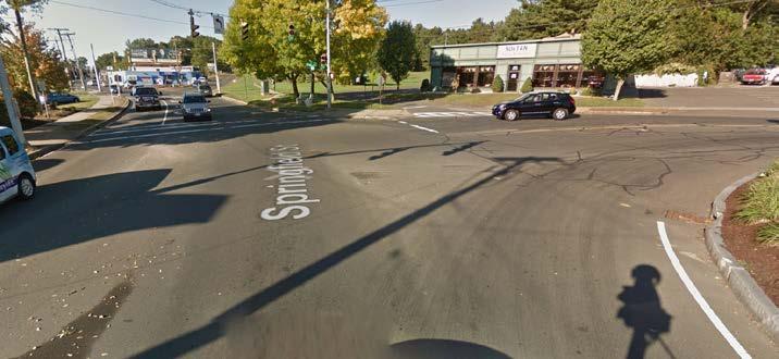
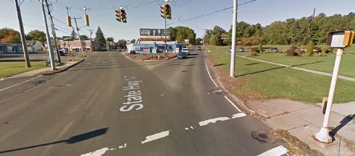
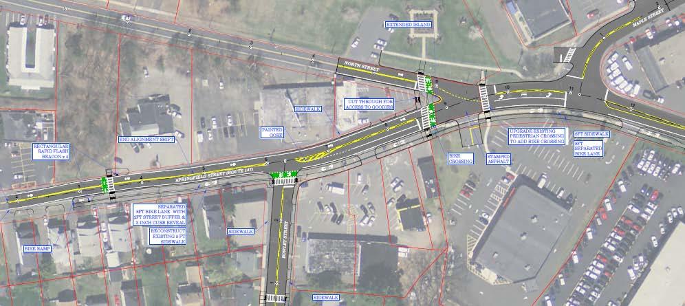
25 DESIGN AND IMPLEMENTATION Tier 3 Project Agawam, MA


26 PEDESTRIAN SAFETY ASSESSMENT Central Square Goal: Evaluate pedestrian safety and infrastructure in Central Square for pedestrian safety plan through an approved Town of Bridgewater Complete Streets Prioritization Plan Approach: Analyze circulation patterns and assess safety, and ADA accessibility. Utilize data collection from Complete Streets and Toolkit strategies to develop a plan To left: WikiMap comments of Central Square as of 4/21/17 (and more to come!) To right: Pedestrian Crash data from GIS of the area


27 EXISTING CENTRAL SQUARE CONDITIONS Bicycle Challenges No bicycle infrastructure; cyclists are riding on the sidewalk with pedestrians Since vehicles are traveling at high speeds, the probability of serious injury is higher for those traveling via bicycle There are no bicycle-specific accommodations at intersections

28 EXISTING CENTRAL SQUARE CONDITIONS Traffic Circulation Junction of inter-regional state routes Broad Street (Route 18) Main Street (Route 28) Summer Street (Route 104) 30,000 vehicles on a typical weekday Equal north/south travel Slightly downward trend of traffic according to historical data Presence of heavy trucks Emergency fire signals allow the Fire Department to enter the rotary in a contraflow direction as needed Emergency Fire Signals
29 EXISTING CENTRAL SQUARE CONDITIONS Intersections

30 EXISTING CENTRAL SQUARE CONDITIONS Intersections: Pedestrian Push Buttons


31 EXISTING CENTRAL SQUARE CONDITIONS Signalized Intersection (North) Northern Side Broad St./Main St./Summer St. Four-Way Signalized Intersection Top 5 Percent Intersection Crash Clusters as identified by MassDOT Turning vehicles are observed not yielding to pedestrians

32 EXISTING CENTRAL SQUARE CONDITIONS Signalized Intersection (North) Northern Side Broad St./Main St./Summer St. Four-Way Signalized Intersection Crossing distances are long due to angled alignment of crosswalks Pedestrian delays are significant due to actuated signal phase sequences Not enough walk time is allotted to cross Central Square under a single pedestrian phase. Pedestrians must stop at the island to wait again Crosswalk Crossing Distance (ft) Crossing Time Needed (sec) Ped Delay (sec) 1 Main Street west (Ø6, P4-P5) Broad Street north ( Ø3, P6-P7) Summer Street east (Ø2, P8-P9) a Central Square south (east, Ø3, P1-P10) b Central Square south (west, Ø4, P2-P3)
33 EXISTING CENTRAL SQUARE CONDITIONS Intersection: Unsignalized Mid-Block Pedestrian Crossings
 Time Needed (sec) Central Sq NB @ Lucky Star")
34 EXISTING CENTRAL SQUARE CONDITIONS Crosswalks Along the Common 6 crosswalks provide connectivity utilizing safe paths through the park Poor pedestrian visibility when attempting to cross towards the Common due to parked cars Angled crosswalks and lack of curb extensions create longer crossing distances for pedestrians Crosswalk Crossing Distance (ft) Time Needed (sec) Central Sq Lucky Star Gas Central Sq My Sister & I Central Sq Bedford Street Central Sq Church Street Central Sq M&S Auto Repair Central Sq Better Bean Coffee Ave. roadway width is 42 (curb to curb)
35 Existing Central Square Conditions: Intersections- Yield/Stop-Controlled Ped Crossings

36 EXISTING CENTRAL SQUARE CONDITIONS Yield-Controlled Intersection (South) Southern Side Two Yield-controlled access points to Central Square South Street and Church Street merge from west Bedford Street and School Street merge from south and east Vehicles exiting rotary are accelerating and traveling at high speeds, crosswalks at Route 104/Route 28 are dangerous for pedestrians Long crossing distances and lack of pedestrian islands make it daunting to enter the crosswalk safely Small sign does not attract enough attention to vehicles that they must stop for pedestrians

37 Next Steps 1. Data collection and analysis 2. Continued stakeholder input 3. Project identification and prioritization For more information: Luciano Rabito Manager of Complete Streets Howard Stein Hudson
38 Questions?


39 Complete Streets Toolkit Rapid Flashing Beacon Flashing Signage Road Diet High Visibility Crosswalk


40 Complete Streets Toolkit In Street Crosswalk Sign Curb Ramp with Tactile Warning Strips Raised Crosswalk Pedestrian Refuge Island


41 Complete Streets Toolkit Tightened Curb Radii Speed Hump Movable Speed Hump Speed Display Signage


42 Complete Streets Toolkit Standard Bike Lane Protected Bike Lane Side Path Wayfinding
Watertown Complete Streets Prioritization Plan. Public Meeting #1 December 14, 2017
 Watertown Complete Streets Prioritization Plan Public Meeting #1 December 14, 2017 Goals for Public Meeting Overview of MassDOT Complete Streets Funding Program Educate the community on Complete Streets
COMPLETE STREETS FUNDING PROGRAM
 COMPLETE STREETS FUNDING PROGRAM Prepared by: MassDOT Highway Division & Office of Transportation Planning Leading the Na 1 Complete Streets Funding Program 1. Background Complete Streets Defined Complete
Bicycle Facilities Planning
 Bicycle Facilities Planning Overview Types of Cyclists Purpose for Riding Types of Facilities Bike Lanes Bicycle Boulevards Cycle Tracks Intersections Signals Signing and Marking Discussion Types of Bicyclists
Guidance. ATTACHMENT F: Draft Additional Pages for Bicycle Facility Design Toolkit Separated Bike Lanes: Two-Way to One-Way Transitions
 ATTACHMENT F: Draft Additional Pages for Bicycle Facility Design Toolkit Separated Bike Lanes: Two-Way to One-Way Transitions This treatment provides a transition from two-way separated bike lanes to one-way
Proposed. City of Grand Junction Complete Streets Policy. Exhibit 10
 Proposed City of Grand Junction Complete Streets Policy Exhibit 10 1 City of Grand Junction Complete Streets Policy Vision: The Complete Streets Vision is to develop a safe, efficient, and reliable travel
Agenda. Overview PRINCE GEORGE S PLAZA METRO AREA PEDESTRIAN PLAN
 PRINCE GEORGE S PLAZA METRO AREA PEDESTRIAN PLAN May 28, 2008 Agenda Welcome and introductions Project overview and issue identification Planning context and strengths Design challenges and initial recommendations
A Matter of Fairness: ROCOG s Environmental Justice Protocol. What is Mobility Limitation?
 No Person Left Behind What is Mobility Limitation? What is the Access Limitation? Environmental Justice population should be provided adequate mobility & access to meet their needs; Identify acceptable
Pedestrian Project List and Prioritization
 To: Kyle Wagenschutz, City of Memphis CC: From: Anne Conlon and John Cock, Alta Planning + Design Date: December, 2014 Re: Project List Development (Task 3.1-3.2) and Project List Prioritization (Task
Bicycle and Pedestrian Connectivity Study. Old Colony Planning Council
 Bicycle and Pedestrian Connectivity Study Old Colony Planning Council Outline Why consider bike/peds in road designs? Why are measures needed? Connecting Land Use with Transportation Evaluation Tools:
Hennepin County Pedestrian Plan Public Comment Report
 Hennepin County Pedestrian Plan Public Comment Report On May 31, 2013, the draft Hennepin County Pedestrian Plan was released for a 45-day public comment period ending July 15, 2013. The county received
PEDESTRIAN ACTION PLAN
 ATTACHMENT 2 CITY OF SANTA MONICA PEDESTRIAN ACTION PLAN CITY OF SANTA MONICA PEDESTRIAN ACTION PLAN This page intentionally left blank EXECUTIVE SUMMARY CHAPTER 1 EXECUTIVE SUMMARY Setting the Stage
APPENDIX A: Complete Streets Checklist DRAFT NOVEMBER 2016
 APPENDIX A: Complete Streets Checklist DRAFT NOVEMBER 2016 Complete Streets Checklist MetroPlan Orlando s Complete Streets Checklist is an internal planning tool for staff to further implementation of
About the Studio. Edward J. Bloustein School of Planning and Public Policy - Rutgers University
 About the Studio Edward J. Bloustein School of Planning and Public Policy - Rutgers University Purpose of studio: Help City of Bayonne apply for Safe Routes to School (SRTS) funding by producing a School
Cycle Track Design Best Practices Cycle Track Sections
 Design Best Practices Sections It is along street segments where the separation and protection methods of cycle tracks offer more comfort than conventional bicycle lanes, and are more attractive to a wide
Off-road Trails. Guidance
 Off-road Trails Off-road trails are shared use paths located on an independent alignment that provide two-way travel for people walking, bicycling, and other non-motorized users. Trails specifically along
BETHEL ROAD AND SEDGWICK ROAD CORRIDOR STUDY
 DRAFT PLAN City Council Meeting August 14, 2017 STUDY AREA Sedgwick Corridor State Route 160, principal arterial with Class 3 access management designation, commuter and freight route, connection to SR
Broad Street Bicycle Boulevard Design Guidelines
 Broad Street Bicycle Boulevard Design Guidelines Building from the strategies introduced in the 2013 Bicycle Transportation Plan and community input received thus far, City Transportation Staff have identified
Dr. M.L. King, Jr. Street North Complete Streets Resurfacing Opportunities HOUSING, LAND USE, AND TRANSPORTATION COMMITTEE MARCH 22, 2018
 Dr. M.L. King, Jr. Street North Complete Streets Resurfacing Opportunities HOUSING, LAND USE, AND TRANSPORTATION COMMITTEE MARCH 22, 2018 What s Happening The City plans to mill and resurface Dr. M.L.
Omaha s Complete Streets Policy
 Omaha s Complete Streets Policy (Adopted August 2015) VISION To create great places and enhance our quality of life, the City of Omaha will provide safe, accessible streets for all users. Complete Streets
Arlington Public Schools New Elementary School at Thomas Jefferson Site Off-Site Transportation. Thomas Jefferson BLPC / PFRC Meeting July 27, 2016
 Arlington Public Schools New Elementary School at Thomas Jefferson Site Off-Site Transportation Thomas Jefferson BLPC / PFRC Meeting July 27, 2016 1.Review of Analysis 2.Key Transportation Issues 3.Recommendations
Bicycle + Pedestrian Connectivity Gap Analysis
 Accelerated Bridge Program Bicycle + Pedestrian Connectivity Gap Analysis Tuesday, October 11 Shriners Hospital, Boston 6:30-8:00 PM Thursday, October 13 Community Rowing, Brighton 6:30-8:00 PM Tuesday,
El Camino Real Specific Plan. TAC/CAC Meeting #2 Aug 1, 2018
 El Camino Real Specific Plan TAC/CAC Meeting #2 Aug 1, 2018 Land Use Alternatives Goals and Tradeoffs Parks & open space Housing Retail & services Civic spaces Parking Community gathering spaces 3 Alternatives
El Paso County 2040 Major Transportation Corridors Plan
 El Paso County 2040 Major Transportation Corridors Plan Connect-our-County Online Transportation User Survey Preliminary Results June 24, 2010 Years of Residence 2. How many years have you LIVED HERE?
PEDESTRIAN ACCOMMODATIONS DPS 201 AT INTERCHANGES
 PEDESTRIAN ACCOMMODATIONS DPS 201 AT INTERCHANGES UNDERSTANDING THE ISSUES Intersections of freeway ramp terminals at crossroads are the most critical components of an interchange Challenge: balance mobility
What Is a Complete Street?
 Session 5 Charleen Zimmer, AICP, Zan Associates May 5-7, 2010 What Is a Complete Street? May 2010 5-1 Not a Complete Street More of a Complete Street May 2010 5-2 Benefits of Complete Streets Safety for
PRINCE GEORGE S PLAZA METRO AREA PEDESTRIAN PLAN
 PRINCE GEORGE S PLAZA METRO AREA PEDESTRIAN PLAN May 28, 2008 Agenda Welcome and introductions Project overview and issue identification Planning context and strengths Design challenges and initial recommendations
Agency Advisory Group Meeting #3 and Walk Audit Anchorage Non-Motorized Plan
 Agency Advisory Group Meeting #3 and Walk Audit Anchorage Non-Motorized Plan Friday, May 18 th Walk Audit 10:00-11:30 AM Meeting 11:30 AM 1:00 PM Municipal Planning Department, 4700 Elmore Road, Training
City of Birmingham Draft Multi-modal Transportation Plan
 City of Birmingham Draft Multi-modal Transportation Plan City Commission Public Hearing Monday, November 25, 2013 7:30 pm Norman Cox, PLA, ASLA The Greenway Collaborative, Inc. Ann Arbor, Michigan The
Draft North Industrial Area-Wide Traffic Plan
 Summary of North Industrial and Hudson Bay Industrial Recommended Improvements Table 1. Summary of s Item Location 1 2 3 4 5 6 7 8 9 10 11 12 Millar Ave north of 51st St Super 8 Motel back lane 400 Block
HYATTSVILLE TRANSPORTATION PLAN. City Council Update March 19, 2018
 HYATTSVILLE TRANSPORTATION PLAN City Council Update March 19, 2018 AGENDA PROJECT GOALS DATA COLLECTION WHAT WE LEARNED NEXT STEPS PROJECT GOALS Identify bicycle and pedestrian needs of the city Evaluate
» Draft Recommendations» Discussion» Next Steps. Plan for Walking and Biking
 SAC Meeting Plan #3 for September Walking and 12, Biking 2018 » Draft Recommendations» Discussion» Next Steps Plan for Walking and Biking » Stakeholder and Public Outreach» Background data collection and
5. RUNNINGWAY GUIDELINES
 5. RUNNINGWAY GUIDELINES These guidelines should be considered collectively when making runningway decisions. A runningway is the linear component of the transit system that forms the right-of-way reserved
CONNECTIVITY PLAN. Adopted December 5, 2017 City of Virginia Beach
 CONNECTIVITY PLAN Adopted December 5, 2017 City of Virginia Beach CONTENTS 1.0 Background & Purpose... 2 2.0 Existing Inventory & Analysis... 3 ViBe District Existing Walking Conditions... 4 3.0 ViBe District
NEWMARKET UPHAM S CORNER
 SOUTH STATION Planning Initiative NEWMARKET UPHAM S CORNER COLUMBIA ROAD (P) FOUR CORNERS/GENEVA Working Advisory Group (WAG) Meeting #5 TALBOT AVENUE MORTON STREET BLUE HILL AVE/CUMMINS HWY (P) RIVER
City of Albert Lea Policy and Procedure Manual 4.10 ALBERT LEA CROSSWALK POLICY
 4.10 ALBERT LEA CROSSWALK POLICY PURPOSE: Pedestrian crosswalks are an integral part of our transportation infrastructure. To be effective and promote safety, marked crosswalks must be installed after
PEDESTRIAN SAFETY IMPROVEMENT EVALUATION GUIDELINE FOR UNCONTROLLED CROSSINGS
 PEDESTRIAN SAFETY IMPROVEMENT EVALUATION GUIDELINE FOR UNCONTROLLED CROSSINGS Traffic Safety Engineering Division Updated: April 2018 EXECUTIVE SUMMARY NDOT Traffic Safety Engineering Division developed
2015 Florida Main Street Annual Conference. Complete Streets Equal Stronger Main Streets
 WHAT ARE COMPLETE STREETS? CASE STUDIES COMPLETING YOUR MAIN STREET 2015 Florida Main Street Annual Conference St. Petersburg, Florida August 19, 2015 WHAT ARE COMPLETE STREETS? CASE STUDIES COMPLETING
MAG Town of Cave Creek Bike Study Task 6 Executive Summary and Regional Significance Report
 Page 1 MAG Town of Cave Creek Bike Study Task 6 Executive Summary and Regional Significance Report August 1, 2012 MAG Project #481 Page 2 Task 6 Executive Summary and Regional Significance Report Introduction
Physical Implications of Complete Streets Policies
 Presentation Overview Physical Implications of Complete Norm Cox, ASLA, LLA Landscape Architect Ann Arbor, Michigan, 10:45 to Noon What Are Complete Streets? What Matters to Bicyclists and Pedestrians
Bicycle and Pedestrian Chapter TPP Update Overview. TAB September 20, 2017
 Bicycle and Pedestrian Chapter TPP Update Overview TAB September 20, 2017 Bicycling & Walking in the Twin Cities Where are we now? The Bike-Pedestrian system Current trends New developments Where are we
Prince George s County plans, policies, and projects
 Prince George s County plans, policies, and projects Over 250 projects for trails, bikeways, designated bike lanes and sidewalk construction Trail projects that improve access to Metro Sidewalk and trail
Who is Toole Design Group?
 2018 AASHTO Bike Guide Status Update NCHRP 15 60 Amalia Leighton Cody, PE, AICP & Kenneth Loen, PE Washington APWA October 4, 2018 Who is Toole Design Group? TDG is a full service engineering, planning
Tonight is for you. Learn everything you can. Share all your ideas.
 Strathcona Neighbourhood Renewal Draft Concept Design Tonight is for you. Learn everything you can. Share all your ideas. What is Neighbourhood Renewal? Creating a design with you for your neighbourhood.
Traffic Improvements for the Transit Oriented Development District (TODD) Meriden Public Library March 11, 2014
 Meriden Public Library March 11, 2014") Traffic Improvements for the Transit Oriented Development District (TODD) Meriden Public Library March 11, 2014 Project Overview Coordinate roadway improvements with other major projects HUB Flood Control
Traffic Improvements for the Transit Oriented Development District (TODD) Meriden Public Library March 11, 2014 Project Overview Coordinate roadway improvements with other major projects HUB Flood Control
Oakland Pedestrian Master Plan Oakland Pedestrian Plan Draft Recommendations Chapter Outline
 EISEN LETUNIC T R A N S P O R T A T I O N, ENVIRO N M E N TA L A N D URBAN PLANNIN G MEMORANDUM To Oakland Pedestrian Plan Technical Advisory Committee & Pedestrian Advisory Group From Victoria Eisen Date
CHAPTER 3: Vision Statement and Goals
 Davidson Walks & Rolls: Active Transportation Master Plan CHAPTER 3 Contents: Overview Vision Statement Measurable Goals Public Outreach CHAPTER 3: Vision Statement and Goals Overview The vision statement
Existing Pedestrian Conditions. PSAC February 8, 2011
 Existing Pedestrian Conditions PSAC February 8, 2011 Contents 1. Project Background & Goals 2. Pedestrian Activity: Where people walk 3. Pedestrian Safety: The conditions people face Project Background
City of Wilsonville 5 th Street to Kinsman Road Extension Project
 City of Wilsonville 5 th Street to Kinsman Road Walking Tour & Neighborhood Workshop Summary Report Public Outreach Overview On July 18 th, 2017, the City of Wilsonville hosted a neighborhood walking tour
City of Sammamish. Welcome. Issaquah-Fall City Road Improvements Project Phase I Design: 242nd Avenue SE to Klahanie Drive SE
 Welcome Welcome to the third community meeting for the Issaquah-Fall City Road Improvements Project. AGENDA 6:00 p.m. Welcome and sign-in 6:10 p.m. Presentation 6:50 p.m. Open house Learn about the roadway
REGIONAL BICYCLE AND PEDESTRIAN DESIGN GUIDELINES
 REGIONAL BICYCLE AND PEDESTRIAN DESIGN GUIDELINES November 16, 2011 Deb Humphreys North Central Texas Council of Governments Bicycle and Pedestrian Advisory Committee Snapshot of the Guide 1. Introduction
ACTIVE TRANSPORTATION
 ACTIVE TRANSPORTATION Mobility 2040 Supported Goals Improve the availability of transportation options for people and goods. Support travel efficiency measures and system enhancements targeted at congestion
6.0 PEDESTRIAN AND BICYCLE FACILITIES 6.1 INTRODUCTION 6.2 BICYCLE DEMAND AND SUITABILITY Bicycle Demand
 6.0 PEDESTRIAN AND BICYCLE FACILITIES 6.1 INTRODUCTION Bicycle and pedestrian travel along and in the vicinity of the corridor is part of the vision of Somerset and Hunterdon counties and the integrated
Active Transportation Facility Glossary
 Active Transportation Facility Glossary This document defines different active transportation facilities and suggests appropriate corridor types. Click on a facility type to jump to its definition. Bike
Rolling Out New Bike Facilities Within the North Bethesda & White Flint Area
 Rolling Out New Bike Facilities Within the North Bethesda & White Flint Area Rolling Out New Bike Facilities Within the North Bethesda & White Flint Area Agenda Designing for all Cyclists Background on
Bicycle-Pedestrian Master Plan: Chapters 3 and 4 Distribution
 Bicycle-Pedestrian Master Plan: Chapters 3 and 4 Distribution Finksburg Planning and Citizens Council March 22, 2018 Overview Progress Citizen Outreach Vision Chapter 3 - Existing Conditions Chapter 4
Public Works Committee Meeting Richard E. Mastrangelo Council Chamber November 20, 2017
 Public Works Committee Meeting Richard E. Mastrangelo Council Chamber November 20, 2017 Purpose of Meeting Why are we here? Project Recap/Updates Project Limits/Segments Road Diet Concept Lessons Learned
Transportation Planning Division
 Transportation Planning Division Presentation Outline Study Tasks Recap of Previous Meetings Data Collected Focus Areas within Study Limits Design Principles Tool Box Recommended Concepts Schedule Moving
Pedestrian Road Safety Audit
 Pedestrian Road Safety Audit Middlebrook Road From Father Hurley Boulevard to Waring Station Road December 2017 Montgomery County Department of Transportation Table of Contents 1. Introduction... 1 1.1
GIS Based Data Collection / Network Planning On a City Scale. Healthy Communities Active Transportation Workshop, Cleveland, Ohio May 10, 2011
 The Purpose of GIS Based Network Planning GIS Based Data Collection / Network Planning Healthy Communities Active Transportation Conference Tuesday, May 10, 2011 10:00 AM Norman Cox, LLA, ASLA. Ann Arbor,
This page intentionally left blank.
 This page intentionally left blank. COMMUNITY Glenpool Community Overview Glenpool Glenpool is a city of nearly 12,000 residents located in Tulsa County southwest of Tulsa and Jenks. The city is growing
Pedestrian Crossing Guidelines 2016
 Pedestrian Crossing Guidelines 2016 Engineering Services 1.0 Introduction and Background The City of Kingston s first Pedestrian Crossing Guidelines were approved by Council in 2008 in order to provide
Albany Shaker Road Corridor Study Public Meeting # 2
 Albany Shaker Road Corridor Study Public Meeting # 2 Scope / Meeting Purpose This project is a CDTC Linkage Study. The Linkage Program is designed to implement the adopted planning and investment principles
Town of Bethlehem. Planning Assessment. Bethlehem Town Board
 Town of Bethlehem US 9W Corridor Transportation Planning Assessment Presented e to: Bethlehem Town Board June 2009 Overview Study Background Route 9W Corridor Conditions and Improvements Selkirk Bypass
The DC Pedestrian Master Plan
 The DC Pedestrian Master Plan September 28, 2010 George Branyan Pedestrian Program Coordinator District Department of Transportation Presentation Agenda Scope of the Plan Methodology Recommendations Implementation
Route 47 (North Main Street) Reconstruction
 Reconstruction") TOWN OF SUNDERLAND Route 47 (North Main Street) Reconstruction Presented by Lou Rabito, P.E. Presented to Town of Sunderland June 11, 2018 Project Overview MassDOT Project No. 607245 Resurfacing and Related
TOWN OF SUNDERLAND Route 47 (North Main Street) Reconstruction Presented by Lou Rabito, P.E. Presented to Town of Sunderland June 11, 2018 Project Overview MassDOT Project No. 607245 Resurfacing and Related
CITY OF COCOA BEACH 2025 COMPREHENSIVE PLAN. Section VIII Mobility Element Goals, Objectives, and Policies
 CITY OF COCOA BEACH 2025 COMPREHENSIVE PLAN Section VIII Mobility Element Goals, Objectives, and Policies Adopted August 6, 2015 by Ordinance No. 1591 VIII MOBILITY ELEMENT Table of Contents Page Number
Protected Bike Lanes in San Francisco Mike Sallaberry SFMTA NACTO Workshop - Chicago IL
 Protected Bike Lanes in San Francisco Mike Sallaberry SFMTA 10 14 2011 NACTO Workshop - Chicago IL San Francisco 2 nd Highest Density in the U.S. 47 square miles Mild Climate Market Population ~810,000
Living Streets Policy
 Living Streets Policy Introduction Living streets balance the needs of motorists, bicyclists, pedestrians and transit riders in ways that promote safety and convenience, enhance community identity, create
Copenhagen Cycling Map. Red Lines Cycling facilities
 Copenhagen Cycling Map Red Lines Cycling facilities Copenhagen Cycling Facilities Design Approaches Transportation without Pollution Copenhagen s Strategy Where Cycling is one of the top key activities
CITY OF CASSELBERRY WINTER PARK DRIVE IMPROVEMENT STUDY
 CITY OF CASSELBERRY WINTER PARK DRIVE IMPROVEMENT STUDY Preliminary Recommendations October 2018 2014 HDR, Inc., all rights reserved. PROJECT BACKGROUND WALKING AUDIT FINDINGS PROPOSED IMPROVEMENT CONCEPTS
Downtown Naples Mobility and Connectivity Study. Naples City Council Presentation January 2017
 Downtown Naples Mobility and Connectivity Study Naples City Council Presentation January 2017 Agenda 1. Introduction 2. Scope Review 3. Project Schedule 4. Existing Conditions 5. Public Charrette 6. Mobility
MASTER BICYCLE AND PEDESTRIAN PLAN
 VILLAGE OF NORTHBROOK MASTER BICYCLE AND PEDESTRIAN PLAN DRAFT PLAN OPEN HOUSE May 2, 2018 AGENDA 1. Community Engagement 2. Vision and Goals 3. General Structure of Plan 4. Recommendations Overview 5.
Balancing Operation & Safety for Motorized and Non-Motorized Traffic
 Balancing Operation & Safety for Motorized and Non-Motorized Traffic Brian Willham, PE, PTOE Iowa Director - MOVITE June 30, 2014 Learning Objectives: When & Why should we measure the performance of complete
Broad Street Bicycle Boulevard City Council Study Session Summary
 Broad Street Bicycle Boulevard City Council Study Session Summary Overview: On August 15 th, 2017, a City Council Study Session was held to invite community input and request City Council guidance on a
MEMORANDUM. Discussion of the planned crosswalk improvement on Mount Vernon Road near Stratham Drive
 MEMORANDUM To: From: Mayor and City Council Michael Smith, Public Works Director Date: August 24, 2015 Subject: Discussion of the Mount Vernon Road Crosswalk Improvement ITEM DESCRIPTION Discussion of
TOWN OF PORTLAND, CONNECTICUT COMPLETE STREETS POLICY
 TOWN OF PORTLAND, CONNECTICUT COMPLETE STREETS POLICY I. VISION, GOALS & PRINCIPLES VISION To improve the streets of Portland making them safer and more accessible for all users including pedestrians,
This page intentionally left blank.
 This page intentionally left blank. COMMUNITY Coweta Community Overview Coweta Coweta, a residential community located in Wagoner County, is a suburb of Tulsa situated southeast of the metropolitan area
Designing for Pedestrian Safety in Washington, DC
 Designing for Pedestrian Safety in Washington, DC February 25, 2014 George Branyan Pedestrian Program Coordinator District Department of Transportation DC Journey to work mode split: 2012 Means of Transportation
Complete Streets for Eastham Prioritization Plan Eastham Library JUNE 13, 2018
 Complete Streets for Eastham Prioritization Plan Eastham Library JUNE 13, 2018 Bridge Street Bridge, Eastham What is a Complete Street? Complete Streets Defined: A Complete Street is one that provides
 COMPLETE STREETS CHECKLIST City of Philadelphia The City of Philadelphia's Complete Streets policies are designed ensure that city streets are safe, comfortable and convenient for people of all ages and
City of Charlottesville Bicycle and Pedestrian Master Plan Update
 City of Charlottesville Bicycle and Pedestrian Master Plan Update September 17, 2014 I. Welcome and meeting overview II. Project status update III. Network overview IV. Break-out groups Pedestrian Network
City of Novi Non-Motorized Master Plan 2011 Executive Summary
 City of Novi Non-Motorized Master Plan 2011 Executive Summary Prepared by: February 28, 2011 Why Plan? Encouraging healthy, active lifestyles through pathway and sidewalk connectivity has been a focus
Designing for Pedestrians: An Engineering Symposium. Rutgers University March 21, 2013
 Designing for Pedestrians: An Engineering Symposium Rutgers University March 21, 2013 The Problem 2 Pedestrian Fatalities Pedestrian Fatalities by Year in US (1994-2010) 6000 5000 4000 3000 2000 1000 0
Complete Streets Chicago: Data Driven Design. Luann Hamilton Deputy Commissioner
 Complete Streets Chicago: Data Driven Design Luann Hamilton Deputy Commissioner AGENDA Chicago s goals Complete Streets & Sustainable Infrastructure Guides Data-Driven Planning Setting goals Scoping/research
Transportation Planning Division
 Transportation Planning Division Presentation Outline Study Tasks Recap of Previous Meeting Stakeholder Interviews Data Collection Design Principles Tool Box Recommendations Schedule Moving Forward North
Non-Motorized Transportation 7-1
 Non-Motorized Transportation 7-1 Transportation facilities no longer mean just accommodating a vehicle powered by a combustion engine. Pedestrian and non-motorized facilities are important modes of travel
Safety & Convenience for All Users, in All Modes. Barbara McCann NCSL December 3, 2013
 Safety & Convenience for All Users, in All Modes Barbara McCann NCSL December 3, 2013 Safety & Convenience for All Users? Who was left out when this road was planned? Takaaki Iwabu for Raleigh News Observer
TRAFFIC CALMING GUIDE FOR TORONTO CITY OF TORONTO TRANSPORTATION SERVICES DIVISION
 TRAFFIC CALMING GUIDE FOR TORONTO CITY OF TORONTO TRANSPORTATION SERVICES DIVISION CITY OF TORONTO TRANSPORTATION SERVICES DIVISION 2016 TRAFFIC CALMING GUIDE FOR TORONTO TABLE OF CONTENTS Introduction
NJDOT Complete Streets Checklist
 Background The New Jersey Department of Transportation s Complete Streets Policy promotes a comprehensive, integrated, connected multi-modal network by providing connections to bicycling and walking trip
COMPLETE STREETS DURING CONSTRUCTION
 COMPLETE STREETS DURING CONSTRUCTION MAINTAINING ACCESSIBILITY FOR ALL Presented by Robbie Burgess, P.E., PTOE Associate Principal Construction Services Manager Howard Stein Hudson rburgess@hshassoc.com
Military Road Safety Improvements
 Military Road Safety Improvements 26 th Road North to 31 st Street North SUMMARY OF DATA REVIEW AND PRELIMINARY RECOMMENDATIONS Prepared for: Department of Environmental Services Traffic Engineering and
Proposed Bridge Street East Bicycle Lanes Public Open House Thursday, April 27, 2017
 WELCOME Proposed Bridge Street East Bicycle Lanes Public Open House Thursday, April 27, 2017 Purpose of the Open House The purpose of this Open House is to gain public input on the bicycle lanes proposed
Implementing Complete Streets in Ottawa. Project Delivery Process and Tools Complete Streets Forum 2015 October 1, 2015
 Implementing Complete Streets in Ottawa October 1, 2015 The Essentials Complete Streets Implementation Framework will become part of the routine delivery of City transportation projects Approach uses every
Bicycle Lanes Planning, Design, Funding South Mountain Partnership Trails Workshop Roy Gothie PennDOT Statewide Bicycle Pedestrian Coordinator
 Bicycle Lanes Planning, Design, Funding 2018 South Mountain Partnership Trails Workshop Roy Gothie PennDOT Statewide Bicycle Pedestrian Coordinator Policy Changes: BOP Bicycle Policy Changes The OLD Way
Citywide Sidewalk and Crosswalk Programs
 Citywide Sidewalk and Crosswalk Programs Council Meeting October 20, 2015 Presented by Rita Hu and Jamal Mahmoud Program Goals Implement the City s comprehensive plan. Provide pedestrian with safe walking
Route 79/Davol Street Corridor Study
 Route 79/Davol Street Corridor Study Fall River, MA Public Information Meeting #2 November 21, 2013 Fall River Heritage State Park Fall River, MA Agenda Welcome and Introductions Overview of Study Process
Complete Streets: Planning, Policy & Performance
 Complete Streets: Planning, Policy & Performance Tell Us About Your CS Experiences Successes Hardships Funding Politics Safety Not every street needs to be complete, but every mode needs a complete network.
Washington County SW Beaverton-Hillsdale Hwy. & SW Scholls Ferry Rd.
 Washington County SW Beaverton-Hillsdale Hwy. & SW Scholls Ferry Rd. SW Beaverton-Hillsdale Hwy. & SW Scholls Ferry Rd. Washington County The SW Beaverton-Hillsdale Hwy & SW Scholls Ferry Rd. focus area
NM-POLICY 1: Improve service levels, participation, and options for non-motorized transportation modes throughout the County.
 Transportation PRINCE WILLIAM COUNTY 2008 COMPREHENSIVE PLAN NON-MOTORIZED PLAN CONTENTS Goals, Policies, and Action Strategies Table 4 (Bike Facility Classifications and Descriptions) Table 5 (Bike Facility
CITY OF LANCASTER PROPOSED NEW PROJECTS
 CITY OF LANCASTER 2013-2014 PROPOSED NEW PROJECTS Project Code 11 Facilities and Fixtures Project Title 1 11BS018 Main. Yard Storage Bldg, Phase 2 2 11GS007 Parks Improvements 3 11GS008 Dog Park AHP 4