Rolling Out New Bike Facilities Within the North Bethesda & White Flint Area
|
|
|
- Lee Fox
- 6 years ago
- Views:
Transcription


1 Rolling Out New Bike Facilities Within the North Bethesda & White Flint Area
2 Rolling Out New Bike Facilities Within the North Bethesda & White Flint Area Agenda Designing for all Cyclists Background on Bicycling in Montgomery County Projects Woodglen Two-Way Separated Bike Lane Completed November 2014 Nebel St. One-Way Separated Bike Lane Completed October 2016 Marinelli Road Proposed One Way Separated Bike Lane Under Design 2017 White Flint western work around (CIP ) New roadways with new bicycle facilities Grosvenor Bicycle & Pedestrian Priority Area (CIP ) Other Bike related amenities Waysides I & II & Trail Lighting Bike racks and repair stations Bike route wayfinding signs


3 Why are we building these new bike facilities? Bicycling is gaining popularity as a mode of transportation throughout the United States. Montgomery County Department of Transportation has a renewed vision and mission that reflects our commitment to creating a first-rate, multimodal transportation system. Montgomery County Department of Transportation has begun to fulfill the recommendations of the Updated Bicycle Master Plan and is investing in the county s low stress bike network to meet the needs of cyclists of any skill level from 8 to 80 years of age. Montgomery County has made a commitment to Vision Zero to reduce roadway fatalities to zero.
 Enthusiastic and Confident (6%) Interested but Concerned (60%) No Way, No How")
4 White Flint Bikeways Update Designing for All Cyclists Montgomery County considers skill level and the Four Types of Cyclists Strong and Fearless (1%) Enthusiastic and Confident (6%) Interested but Concerned (60%) No Way, No How (33%)


5 Designing for All Cyclists From Strong & Fearless to Interested but Concerned White Flint Bikeways Update


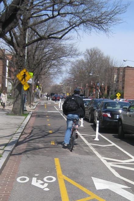


6 White Flint Bikeways Update Spectrum of Bicycle Facilities higher stress lower stress Shared-Lane Markings ( Sharrows ) Bike Lane Buffered Bike Lane Separated Bike Lane Shared-Use Path


7 Our first suburban twoway separated bike lane was constructed in White Flint along Woodglen Drive, which included the first bike box in the county. Designs and approvals for additional separated bike lanes have been completed in White Flint and Silver Spring CBD. This past summer, MCDOT constructed two separated bike lane projects: Nebel St. & Glenbrook Rd. Spring St. will be under construction in Spring 17 & Marinelli Rd. is under design. Building the county s low stress bike network has begun.

8 Separated bike lanes (also known as cycle tracks) are bicycle-only facilities that are separated from auto traffic by a physical barrier, such as parked cars, bollards, a landscaped buffer, or a curb. Separated bike lanes may be one-way or two-way and can be raised or at street-level. One-way separated bike lane Nebel St. completed. Marinelli Road under design in 2017 Two-way separated bike lane Woodglen completed. Woodmont Avenue under design in

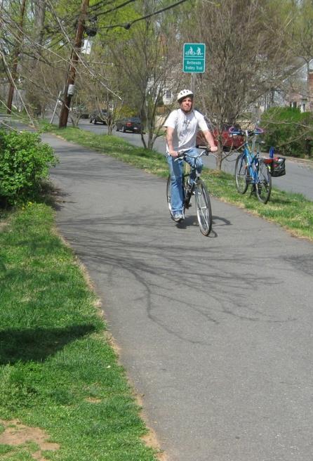
9 White Flint Bikeways Update Nicholson Ln. to Edson Ln. WOODGLEN DR. SEPARATED BIKE LANE Future phase to Marinelli Rd


10 White Flint Bikeways Update WOODGLEN DR. SEPARATED BIKE LANE Two-Way Separated Bike Lane, separated by parking, buffer, and flexible posts

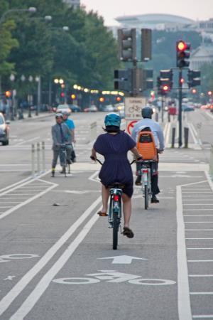
11 White Flint Bikeways Update 15 th St, NW, DC WOODGLEN DR. TWO-WAY SEPARATED BIKE LANE Separation from traffic is comfortable for bicyclists of varying ages and comfort levels

12 Woodglen Dr. Separated Bike Lane New signage has been installed to show motorists that parking spaces have corresponding curbside parking meters.
.")
13 Intersections Bike boxes Montgomery County already has one of these on Woodglen Drive (2014). 15 Woodglen Drive and Nicholson Lane

14 WOODGLEN DR. SEPARATED BIKE LANE White Flint Bikeways Update Woodglen Drive and Edson Lane in North Bethesda Green pavement identifies conflict areas at driveways and intersections

15 Existing/Future Two-Way Separated Bike Lane Woodglen Drive NEBEL STREET SEPARATED BIKE LANES (FROM RANDOLPH ROAD TO MARINELLI ROAD) Existing Shared-Use Paths Randolph Road Near Future Bike Facility Marinelli Road 17 ** Map illustrates existing and near future bicycle facilities forming a continuous route through White Flint connecting existing shared use paths.
16 NEBEL STREET SEPARATED BIKE LANES (FROM RANDOLPH ROAD TO MARINELLI ROAD) Delineator Parking west east Swap location of parking with bike lane on east side Add vertical flexible delineator in buffer Reduced width of travel lanes to 11 Removed parking on the west side (20 spaces) shifting gears for a better ride ahead


17 NEBEL STREET SEPARATED BIKE LANES (FROM RANDOLPH ROAD TO MARINELLI ROAD) Bike box Bike crosswalks Protective Concrete islands New ADA ramps Pedestrian refuge islands 6-foot one-way separated bike lanes 10-foot turn lane 11-foot travel lanes High visibility crosswalks OLD GEORGETOWN & NEBEL STREET

18 NEBEL STREET SEPARATED BIKE LANES (FROM RANDOLPH ROAD TO MARINELLI ROAD)


19 NEBEL STREET SEPARATED BIKE LANES (FROM RANDOLPH ROAD TO MARINELLI ROAD)

20 Intersections Two-stage queue boxes Most signalized intersections will get two-stage queue boxes. Benefits of two-stage queue boxes: Allows safer/more comfortable left turns for cyclists off of the cycletrack. Separates turning cyclists from through cyclists. Reduces turning conflicts between cyclists and motorists. 22


")
21 NEBEL STREET SEPARATED BIKE LANES (FROM RANDOLPH ROAD TO MARINELLI ROAD)


22 Marinelli Road Proposed One Way Separated Bike Lane from Nebel Street to MD 355 Currently under design in


23 Marinelli Road Proposed One Way Separated Bike Lane from Nebel Street to MD 355 Currently under design in


24 White Flint Western Work Around CIP
25 Bicycle & Pedestrian Priority Areas (BiPPA)-CIP Grosvenor (one of first five to be studied) Grosvenor BiPPA Improvements in FY 17 & FY 18 30
 and Strathmore Mansion driveway Landscaping/gateway feature along MD 355 MD 355 sidewalk gap (east side): Grosvenor Ln to Pooks Hill Rd under concept")
26 Grosvenor BiPPA In FY 2017, MCDOT will be working on improvements in Grosvenor. Projects in design: Median refuge islands across MD 547 at Jolly Ln & Stillwater Ave. Shared-use path between Tuckerman Lane (north) and Strathmore Mansion driveway Landscaping/gateway feature along MD 355 MD 355 sidewalk gap (east side): Grosvenor Ln to Pooks Hill Rd under concept development in FY 17 Deferred: Tuckerman Lane bike lanes (east of MD 355) delayed due to paving schedule adjustment (funded by Highway Services). Anticipate in Fall


27 Grosvenor BiPPA Jolly Ln median refuge Stillwater Ave median refuge 32

28 Grosvenor BiPPA MD 355 shared-use path 33


29 Wayside I and II and BTT Lighting 34

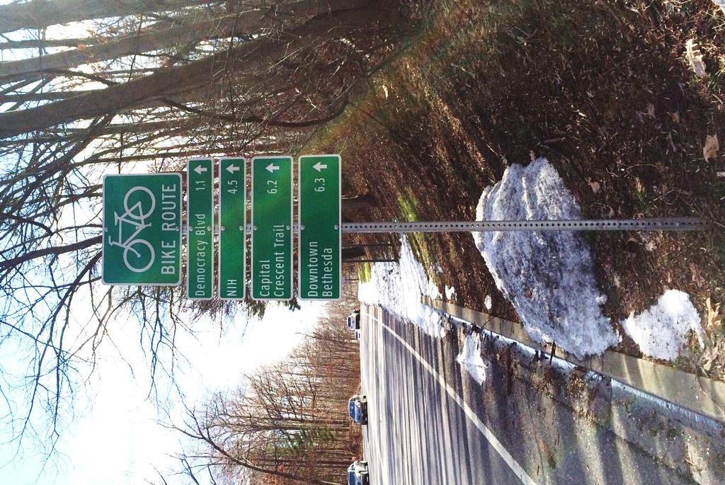
30 Bicycle Route Wayfinding 35


31 Patricia Shepherd, AICP Bikeways Program Manager Division of Transportation Engineering Phone: Learn more: Follow Get Involved: MCBAG: Montgomery County Bicycle Action Group
SHIFTING GEARS. for a better ride ahead. MONTGOMERY COUNTY DEPARTMENT OF TRANSPORTATION April 5, 2014
 SHIFTING GEARS for a better ride ahead MONTGOMERY COUNTY DEPARTMENT OF TRANSPORTATION April 5, 2014 CYCLING IN THE USA The number of bicyclists is growing rapidly in the United States Transportation &
Proposed White Flint Separated Bike Lane Network September 2015
 Proposed White Flint Separated Bike Lane Network September 2015 Abstract This report includes a proposed separated bike lane network for the White Flint Sector Plan area. Separated bike lanes create a
2015 BIKE SUMMIT SHIFTING GEARS
 SHIFTING GEARS Bicycling is the most energy efficient form of transportation Bicycles increase mobility independence for all ages Biking is good for the body, mind and spirit Cycling is low impact on the
MONTGOMERY COUNTY COUNCIL
 MONTGOMERY COUNTY COUNCIL R O C K V I L L E, M A R Y L A N D October 20, 2015 The Honorable Isiah Leggett Montgomery County Executive 101 Monroe Street, 2nd Floor Rockville, MD 20850 Dear County Executive
Bicycle Facilities Planning
 Bicycle Facilities Planning Overview Types of Cyclists Purpose for Riding Types of Facilities Bike Lanes Bicycle Boulevards Cycle Tracks Intersections Signals Signing and Marking Discussion Types of Bicyclists
MONTGOMERY COUNTY PLANNING DEPARTMENT THE MARYLAND-NATIONAL CAPITAL PARK AND PLANNING COMMISSION
 MONTGOMERY COUNTY PLANNING DEPARTMENT THE MARYLAND-NATIONAL CAPITAL PARK AND PLANNING COMMISSION MCPB Item No. 5 Date: 12/3/15 Draft White Flint Separated Bike Lanes Network David Anspacher, Functional
Cycle Track Design Best Practices Cycle Track Sections
 Design Best Practices Sections It is along street segments where the separation and protection methods of cycle tracks offer more comfort than conventional bicycle lanes, and are more attractive to a wide
MONTGOMERY COUNTY COUNCIL MEMORANDUM
 MONTGOMERY COUNTY COUNCIL R O C K V I L L E, M A R Y L A N D HANS RIEMER COUNCILMEMBER AT-LARGE MEMORANDUM To: T&E Committee From: Councilmember Hans Riemer Date: March 1, 2016 Re: Funding a Protected
Broad Street Bicycle Boulevard Design Guidelines
 Broad Street Bicycle Boulevard Design Guidelines Building from the strategies introduced in the 2013 Bicycle Transportation Plan and community input received thus far, City Transportation Staff have identified
September The State of Bicycling in Montgomery County
 September 2015 The State of Bicycling in Montgomery County The State of Bicycling in Montgomery County Abstract: This report documents the state of bicycling in Montgomery County as of September 2015.
Clybourn Ave. Protected Bike Lane Study Halsted St. to Division St.
 Clybourn Ave. Protected Bike Lane Study Halsted St. to Division St. Nathan Roseberry, Senior Engineer Pam Broviak, Project Manager July 24, 2014 Agenda Project Goals Existing Roadway Conditions Traffic
Color your stress away
 Color your stress away Learn about the Bicycle Master Plan s comfortable, low-stress bicycling network in Montgomery County. Unwind as you color the bicycling scenes. Check out montgomeryplanning.org/bikeplan
MCPB Item No. 5 Date: White Flint West Transportation, Phase 2, CIP No , Mandatory Referral No. MR
 MONTGOMERY COUNTY PLANNING DEPARTMENT THE MARYLAND-NATIONAL CAPITAL PARK AND PLANNING COMMISSION MCPB Item No. 5 Date: 09-10-15 White Flint West Transportation, Phase 2, CIP No. 501116, Mandatory Referral
PRINCE GEORGE S PLAZA METRO AREA PEDESTRIAN PLAN
 PRINCE GEORGE S PLAZA METRO AREA PEDESTRIAN PLAN May 28, 2008 Agenda Welcome and introductions Project overview and issue identification Planning context and strengths Design challenges and initial recommendations
MAG Town of Cave Creek Bike Study Task 6 Executive Summary and Regional Significance Report
 Page 1 MAG Town of Cave Creek Bike Study Task 6 Executive Summary and Regional Significance Report August 1, 2012 MAG Project #481 Page 2 Task 6 Executive Summary and Regional Significance Report Introduction
Agenda. Overview PRINCE GEORGE S PLAZA METRO AREA PEDESTRIAN PLAN
 PRINCE GEORGE S PLAZA METRO AREA PEDESTRIAN PLAN May 28, 2008 Agenda Welcome and introductions Project overview and issue identification Planning context and strengths Design challenges and initial recommendations
Watertown Complete Streets Prioritization Plan. Public Meeting #1 December 14, 2017
 Watertown Complete Streets Prioritization Plan Public Meeting #1 December 14, 2017 Goals for Public Meeting Overview of MassDOT Complete Streets Funding Program Educate the community on Complete Streets
LANCASTER CITY BICYCLE NETWORK
 LANCASTER CITY BICYCLE NETWORK Downtown Merchants Meeting Wednesday, July 19, 2017 http://www.lancasteratp. DOWNTOWN WALKABILITY ANALYSIS What changes can be made, in the least amount of time, and for
Zlatko Krstulich, P.Eng. City of O9awa
 Zlatko Krstulich, P.Eng. City of O9awa 1. Introduction to the Ontario Traffic Manual Series 2. What is OTM Book 18: Bicycle Facilities? 3. Study / Committee Team Members 4. Brief overview of the content
Off-road Trails. Guidance
 Off-road Trails Off-road trails are shared use paths located on an independent alignment that provide two-way travel for people walking, bicycling, and other non-motorized users. Trails specifically along
Physical Implications of Complete Streets Policies
 Presentation Overview Physical Implications of Complete Norm Cox, ASLA, LLA Landscape Architect Ann Arbor, Michigan, 10:45 to Noon What Are Complete Streets? What Matters to Bicyclists and Pedestrians
Active Transportation Facility Glossary
 Active Transportation Facility Glossary This document defines different active transportation facilities and suggests appropriate corridor types. Click on a facility type to jump to its definition. Bike
APPENDIX A: Complete Streets Checklist DRAFT NOVEMBER 2016
 APPENDIX A: Complete Streets Checklist DRAFT NOVEMBER 2016 Complete Streets Checklist MetroPlan Orlando s Complete Streets Checklist is an internal planning tool for staff to further implementation of
Sharrows and Elephants and Bike Boxes!, s, Oh My!
 Sharrows and Elephants and Bike Boxes!, s, Oh My! New Traffic Control Devices on Vancouver s Bike Routes David Rawsthorne, P.Eng. City of Vancouver Engineering g Services CITE Quad Conference, May 2009
Who is Toole Design Group?
 2018 AASHTO Bike Guide Status Update NCHRP 15 60 Amalia Leighton Cody, PE, AICP & Kenneth Loen, PE Washington APWA October 4, 2018 Who is Toole Design Group? TDG is a full service engineering, planning
NJDOT Complete Streets Checklist
 Background The New Jersey Department of Transportation s Complete Streets Policy promotes a comprehensive, integrated, connected multi-modal network by providing connections to bicycling and walking trip
Omaha s Complete Streets Policy
 Omaha s Complete Streets Policy (Adopted August 2015) VISION To create great places and enhance our quality of life, the City of Omaha will provide safe, accessible streets for all users. Complete Streets
Lessons Learned from Cycle Tracks (Class IV Bikeways) Design Practice
 Design Practice") Lessons Learned from Cycle Tracks (Class IV Bikeways) Design Practice By: Min Zhou, P.E., Principal/Vice President KOA Corporation 1 What is a Cycle Track (Class IV) TYPICAL BIKEWAY CLASSIFICATION CLASS
Lessons Learned from Cycle Tracks (Class IV Bikeways) Design Practice By: Min Zhou, P.E., Principal/Vice President KOA Corporation 1 What is a Cycle Track (Class IV) TYPICAL BIKEWAY CLASSIFICATION CLASS
Bridgewater Complete Streets Prioritization Plan and Pedestrian Safety Assessment
 Bridgewater Complete Streets Prioritization Plan and Pedestrian Safety Assessment Presented by Luciano Rabito Manager of Complete Streets Presented to Bridgewater, MA Wednesday, April 26, 2017 6:30 P.M.
Prince George s County plans, policies, and projects
 Prince George s County plans, policies, and projects Over 250 projects for trails, bikeways, designated bike lanes and sidewalk construction Trail projects that improve access to Metro Sidewalk and trail
Table #6 VISION CHARACTERISTICS
 Table #6 VISION White Flint is a place to live, work, play, shop, and walk with sufficient density to encourage quality redevelopment. Vibrant streets and consistent streetscapes are important. CHARACTERISTICS
Bicycle-Pedestrian Master Plan: Chapters 3 and 4 Distribution
 Bicycle-Pedestrian Master Plan: Chapters 3 and 4 Distribution Finksburg Planning and Citizens Council March 22, 2018 Overview Progress Citizen Outreach Vision Chapter 3 - Existing Conditions Chapter 4
City of Sammamish. Welcome. Issaquah-Fall City Road Improvements Project Phase I Design: 242nd Avenue SE to Klahanie Drive SE
 Welcome Welcome to the third community meeting for the Issaquah-Fall City Road Improvements Project. AGENDA 6:00 p.m. Welcome and sign-in 6:10 p.m. Presentation 6:50 p.m. Open house Learn about the roadway
North Avenue Corridor Study
 North Avenue Corridor Study Advisory Committee Meeting #6 July 1, 2014 Agenda Concept Revisions based on Advisory Committee feedback Review of New Concept Scoring & Costs Concept Discussion/Questions Voting:
Bicycle and Pedestrian Chapter TPP Update Overview. TAB September 20, 2017
 Bicycle and Pedestrian Chapter TPP Update Overview TAB September 20, 2017 Bicycling & Walking in the Twin Cities Where are we now? The Bike-Pedestrian system Current trends New developments Where are we
Completing the Street: Denning Drive
 Completing the Street: Denning Drive Public Workshop and Walking Audit Winter Park Civic Center May 12, 2016 Completing the Street What Makes This a Complete Street? Completing the Street Complete Streets
Dr. M.L. King, Jr. Street North Complete Streets Resurfacing Opportunities HOUSING, LAND USE, AND TRANSPORTATION COMMITTEE MARCH 22, 2018
 Dr. M.L. King, Jr. Street North Complete Streets Resurfacing Opportunities HOUSING, LAND USE, AND TRANSPORTATION COMMITTEE MARCH 22, 2018 What s Happening The City plans to mill and resurface Dr. M.L.
Guidance. ATTACHMENT F: Draft Additional Pages for Bicycle Facility Design Toolkit Separated Bike Lanes: Two-Way to One-Way Transitions
 ATTACHMENT F: Draft Additional Pages for Bicycle Facility Design Toolkit Separated Bike Lanes: Two-Way to One-Way Transitions This treatment provides a transition from two-way separated bike lanes to one-way
INDOT Complete Streets Guideline & Policy
 INDOT Complete Streets Guideline & Policy INTRODUCTION The Complete Streets guidelines build upon multiple efforts and promote a multimodal transportation system that is integrated and sustains land use
Small Town & Rural Multimodal Networks
 Small Town & Rural Multimodal Networks Fred Young, PLA Andrea Clinkscales, AICP, PMP Alta Planning + Design Funding Partners Project Team Existing Design Guidance AASHTO Flexibility Guide 2004 AASHTO Bike
9/25/2018. Multi-Modal Level of Service (MMLOS) Bianca Popescu, Transportation Planner
 Bianca Popescu, Transportation Planner") Multi-Modal Level of Service (MMLOS) Bianca Popescu, Transportation Planner 1 What is MMLOS? Is this a nice place to walk? Is this a nice place to bike? Is transit convenient? Bottom line - Are there options
Multi-Modal Level of Service (MMLOS) Bianca Popescu, Transportation Planner 1 What is MMLOS? Is this a nice place to walk? Is this a nice place to bike? Is transit convenient? Bottom line - Are there options
Columbia Pike Implementation Team (CPIT) Meeting
 Meeting") Columbia Pike Implementation Team (CPIT) Meeting November 30, 2010 Agenda Introductions / Purpose of Meeting Review of project goals Multimodal project: 10% street design between the curbs Discussion Multimodal
Columbia Pike Implementation Team (CPIT) Meeting November 30, 2010 Agenda Introductions / Purpose of Meeting Review of project goals Multimodal project: 10% street design between the curbs Discussion Multimodal
City of Charlottesville Bicycle and Pedestrian Master Plan Update
 City of Charlottesville Bicycle and Pedestrian Master Plan Update September 17, 2014 I. Welcome and meeting overview II. Project status update III. Network overview IV. Break-out groups Pedestrian Network
Pedestrian & Bicycle Safety Innovations & Applications
 Pedestrian & Bicycle Safety Innovations & Applications County Engineers Association of Maryland Spring, 2017 Conference May 25, 2017 George Branyan Pedestrian Program Coordinator District Department of
Complete Streets: Planning, Policy & Performance
 Complete Streets: Planning, Policy & Performance Tell Us About Your CS Experiences Successes Hardships Funding Politics Safety Not every street needs to be complete, but every mode needs a complete network.
Bicycle and Pedestrian Connectivity Study. Old Colony Planning Council
 Bicycle and Pedestrian Connectivity Study Old Colony Planning Council Outline Why consider bike/peds in road designs? Why are measures needed? Connecting Land Use with Transportation Evaluation Tools:
Bike Planning: A New Day
 Bike Planning: A New Day Josh Sikich, AICP, LEED AP Chicago Office Director Alta Planning + Design 312-265-0628 joshuasikich@altaplanning.com cities of all sizes are changing Illinois Bike Summit October
Simulation Analysis of Intersection Treatments for Cycle Tracks
 Abstract Simulation Analysis of Intersection Treatments for Cycle Tracks The increased use of cycle tracks also known as protected bike lanes has led to investigations of how to accommodate them at intersections.
Coquitlam Cross-town Bike Route Improving Bicycle Facilities in a Mature Suburban Environment
 Coquitlam Cross-town Bike Route Improving Bicycle Facilities in a Mature Suburban Environment Sarah Rocchi, Vice-President, Projects, Opus International Consultants (Main Presenter) Catherine Mohoruk,
G AT E WAY PLAN. Community BRIEFING KIT GATEWAY BIKE
 G AT E WAY PLAN GATEWAY BIKE Community BRIEFING KIT PLAN August 2016 TABLE OF CONTENTS INTRODUCTION... 1 THE BENEFITS OF A BIKEABLE COMMUNITY... 2 ECONOMY...2 SAFETY...3 HEALTH...3 HOUSEHOLD SPENDING...3
2018 AASHTO BIKE GUIDE
 2018 AASHTO BIKE GUIDE Your presenter Rob Burchfield, PE NW Regional Engineering Director 35 years of experience in traffic engineering and bicycle facility design Toole Design Group Toole Design Group
and older adults and people with disabilities still face barriers when using the pedestrian network and public transportation.
 Background Afterthe1980Olympics,theLakePlacid/NorthElbacommunityadoptedaneconomicstrategy ofdevelopingandmarketingeventstoincreaseareatourism.thisstrategyhasbeenvery successful.overrecentyearsthevolumeofvisitorshasincreased,andthelengthofthe
CITY OF SLO SEEKS INPUT ON PREFERRED ALTERNATIVE FOR BROAD STREET BICYCLE BOULEVARD PROJECT
 City of San Luis Obispo, News Release DATE: August 1, 2017 RELEASE: Immediate CONTACT: Luke Schwartz (805) 781-7190 Transportation Planner-Engineer, Public Works CITY OF SLO SEEKS INPUT ON PREFERRED ALTERNATIVE
FOCUS AREA 1 - Alberta Avenue Pocket Park 3 (121 Ave and 92 St)
") FOCUS AREA 1 - Alberta Avenue Pocket Park 3 (121 Ave and 92 St) New benches Plant evergreen trees Widen existing sidewalk from 1.5m to 1.8m Marked crosswalk 1.8m wide sidewalk Add pedestrian oriented lights
FOCUS AREA 1 - Alberta Avenue Pocket Park 3 (121 Ave and 92 St) New benches Plant evergreen trees Widen existing sidewalk from 1.5m to 1.8m Marked crosswalk 1.8m wide sidewalk Add pedestrian oriented lights
El Centro Mobility Hub
 The El Centro drive shed comprises a major portion of the El Centro downtown area, which is well served by bus routes. The proposals intend to promote use of public transit through improvements and enhancements
Appendix C. TRAFFIC CALMING PROGRAM TOOLBOX
 Appendix C. TRAFFIC CALMING PROGRAM TOOLBOX PHASE I...2 Do Not Enter Sign...3 One-Way Sign...4 Turn Prohibition...5 Pavement Markings...6 Speed Monitoring Trailer...7 Neighborhood Speed Watch...8 Police
May 4, Dear Mr. Thomas and Mr. Snyder,
 Daniel Thomas, Principal Planner Christopher Snyder, County Engineer DuPage County Division of Transportation 421 N County Farm Road Wheaton, IL 60187 May 4, 2016 Dear Mr. Thomas and Mr. Snyder, On behalf
FHWA Bikeway Selection Guide
 FHWA Bikeway Selection Guide Tamara Redmon Federal Highway Administration Bill Schultheiss Toole Design Lauren Blackburn VHB March 26, 2019 PBIC Webinar pedbikeinfo.org @pedbikeinfo Housekeeping Problems
WELCOME! Please complete a comment sheet as we value your feedback. 4 pm to 8 pm. September 15, Hosted by: AECOM on behalf of City of Calgary
 WELCOME! Thank you for attending our open house. There will be no formal presentation today so please take the time to read the boards. If you have any questions, please do not hesitate to approach one
NM-POLICY 1: Improve service levels, participation, and options for non-motorized transportation modes throughout the County.
 Transportation PRINCE WILLIAM COUNTY 2008 COMPREHENSIVE PLAN NON-MOTORIZED PLAN CONTENTS Goals, Policies, and Action Strategies Table 4 (Bike Facility Classifications and Descriptions) Table 5 (Bike Facility
Overview. Illinois Bike Summit IDOT Complete Streets Policy Presentation. What is a Complete Street? And why build them? And why build them?
 Overview Illinois Bike Summit IDOT Complete Streets Policy Presentation Aren Kriks, P.E. District One Bicycle Coordinator and Bureau of Programming Project Engineer History of Complete Streets IDOT Policy
TRAFFIC CALMING GUIDE FOR TORONTO CITY OF TORONTO TRANSPORTATION SERVICES DIVISION
 TRAFFIC CALMING GUIDE FOR TORONTO CITY OF TORONTO TRANSPORTATION SERVICES DIVISION CITY OF TORONTO TRANSPORTATION SERVICES DIVISION 2016 TRAFFIC CALMING GUIDE FOR TORONTO TABLE OF CONTENTS Introduction
5. RUNNINGWAY GUIDELINES
 5. RUNNINGWAY GUIDELINES These guidelines should be considered collectively when making runningway decisions. A runningway is the linear component of the transit system that forms the right-of-way reserved
Safe Routes to School Action Plan Aberdeen, Idaho
 Background Aberdeen, Idaho is a largely agricultural community of nearly 2,000 people and is located in the southeast portion of the state on the western edge of American Falls Reservoir. The community
Non-Motorized Transportation 7-1
 Non-Motorized Transportation 7-1 Transportation facilities no longer mean just accommodating a vehicle powered by a combustion engine. Pedestrian and non-motorized facilities are important modes of travel
95 th Street Corridor Transportation Plan. Steering Committee Meeting #2
 95 th Street Corridor Transportation Plan Steering Committee Meeting #2 February 18, 2015 PURPOSE OF THE MEETING Update Steering Committee Present Community/Stakeholder Survey Results Present Transportation
APPENDIX D LEVEL OF TRAFFIC STRESS METHODOLOGY
 APPENDIX D LEVEL OF TRAFFIC STRESS METHODOLOGY 01 WHAT IS LEVEL OF TRAFFIC STRESS? When people bicycle on roadways, they encounter varying levels of stress from traffic. A quiet residential street with
WHEREAS delivery trucks also pass through the Narrows, into the northern parking lot, to loading docks in the back of the building.
 CEDAR-ISLES-DEAN NEIGHBORHOOD ASSOCIATION ( CIDNA ) RESOLUTION OPPOSING A DRUG STORE DRIVE THRU, AND COMMENDING DORAN COMPANIES FOR PROPOSING MITIGATING AMENITIES INCLUDING NEW LANDSCAPING AND A DEDICATED
Mission-Geneva Transportation Study Community Workshop 2 July 8, 2006
 Community Workshop 2 July 8, 2006 Small Group Workbook 1 Basic Improvements on Mission Street Streetscape. Pedestrian-scale lighting; landscaping; community art on utility boxes; more (possibly unique)
Saskatchewan Drive Roadway Rehabilitation and Shared-Use Path Widening
 Saskatchewan Drive Roadway Rehabilitation and Shared-Use Path Widening We are here today to present the draft plan for the Saskatchewan Drive Roadway Rehabilitation and Shared-Use Path Widening project
Tonight is for you. Learn everything you can. Share all your ideas.
 Strathcona Neighbourhood Renewal Draft Concept Design Tonight is for you. Learn everything you can. Share all your ideas. What is Neighbourhood Renewal? Creating a design with you for your neighbourhood.
Pennsylvania Avenue (CR 484) Design Alternatives Study
 Design Alternatives Study") MEMORANDUM Pennsylvania Avenue (CR 484) Design Alternatives Study Prepared for: APRIL 2016 Prepared By TABLE OF CONTENTS Project Background... 2 Previous Concept... 2 Existing Conditions... 4 New Alternatives...
MEMORANDUM Pennsylvania Avenue (CR 484) Design Alternatives Study Prepared for: APRIL 2016 Prepared By TABLE OF CONTENTS Project Background... 2 Previous Concept... 2 Existing Conditions... 4 New Alternatives...
SAN FRANCISCO MUNICIPAL TRANSPORTATION AGENCY
 THIS PRINT COVERS CALENDAR ITEM NO. : 12 DIVISION: Sustainable Streets BRIEF DESCRIPTION: SAN FRANCISCO MUNICIPAL TRANSPORTATION AGENCY Approving various bicycle improvements and traffic modifications
CRESTON ROAD COMPLETE AND SUSTAINABLE STREETS CORRIDOR PLAN
 CRESTON ROAD COMPLETE AND SUSTAINABLE STREETS CORRIDOR PLAN Preferred Plan Community Presentation September 27, 2017 City of El Paso de Robles in partnership with: Local Government Commission, W-Trans,
PBIC Webinar. How to Create a Bicycle Safety Action Plan: Planning for Safety [IMAGE] Oct. 2, 2014, 2 pm
![PBIC Webinar. How to Create a Bicycle Safety Action Plan: Planning for Safety [IMAGE] Oct. 2, 2014, 2 pm](/thumbs/86/93953441.jpg "PBIC Webinar. How to Create a Bicycle Safety Action Plan: Planning for Safety [IMAGE] Oct. 2, 2014, 2 pm") PBIC Webinar How to Create a Bicycle Safety Action Plan: Planning for Safety [IMAGE] Bill Schultheiss, Vice President, Toole Design Peter Lagerwey, Regional Director, Toole Design Oct. 2, 2014, 2 pm Today
PBIC Webinar How to Create a Bicycle Safety Action Plan: Planning for Safety [IMAGE] Bill Schultheiss, Vice President, Toole Design Peter Lagerwey, Regional Director, Toole Design Oct. 2, 2014, 2 pm Today
DRAFT - CITY OF MEDFORD TRANSPORTATION SYSTEM PLAN Roadway Cross-Sections
 Roadway Cross-Sections Medford s roadway cross-section standards apply to new and reconstructed roads. The crosssections take into consideration roadway function and operational characteristics, including
Improvements Infrastructure Gap Assessment and Improvements Street Striping
 Infrastructure Project Proposal The federal-aid Safe Routes to School program funds infrastructure/engineering projects that fall into two categories: Design (available only to School Development Authority
What Is a Complete Street?
 Session 5 Charleen Zimmer, AICP, Zan Associates May 5-7, 2010 What Is a Complete Street? May 2010 5-1 Not a Complete Street More of a Complete Street May 2010 5-2 Benefits of Complete Streets Safety for
Prioritization of Bicycle Supportive Laws, Regulations and Policies. Recommended Expanded Bicycle-Supportive Programs
 1) Table of Contents, Add these subsections: s Bicycle Facility Classifications General Application Breezeway Network Recommendations Bicycle Parking Short-Term Bicycle Parking Long-Term Bicycle Parking
CONNECTIVITY PLAN. Adopted December 5, 2017 City of Virginia Beach
 CONNECTIVITY PLAN Adopted December 5, 2017 City of Virginia Beach CONTENTS 1.0 Background & Purpose... 2 2.0 Existing Inventory & Analysis... 3 ViBe District Existing Walking Conditions... 4 3.0 ViBe District
REGIONAL BICYCLE AND PEDESTRIAN DESIGN GUIDELINES
 REGIONAL BICYCLE AND PEDESTRIAN DESIGN GUIDELINES November 16, 2011 Deb Humphreys North Central Texas Council of Governments Bicycle and Pedestrian Advisory Committee Snapshot of the Guide 1. Introduction
Houma-Thibodaux Metropolitan Planning Organization STP<200K Funding Application APPLICATION
 APPLICATION HOUMA-THIBODAUX METROPOLITAN PLANNING ORGANIZATION (HTMPO) FOR SURFACE TRANSPORTATION PROGRAM (STP
ARLINGTON COUNTY PAVEMENT MARKING SPECIFICATIONS
 DEPARTMENT OF ENVIRONMENTAL SERVICES ARLINGTON COUNTY PAVEMENT MARKING SPECIFICATIONS MAY 2017 Table of Contents 1. General... 2 2. Design Criteria... 3 3. Marking Plan Preparation... 4 Exhibits... 5 MK
DISTRICT BICYCLE PROGRAM
 DISTRICT BICYCLE PROGRAM TxDOT Fort Worth District Public Hearing Bicycle Use on the State Highway System Public Hearing Agenda 1 2 3 4 5 6 Introduction Susan Howard TxDOT Public Involvement Specialist
COMPLETE STREETS FUNDING PROGRAM
 COMPLETE STREETS FUNDING PROGRAM Prepared by: MassDOT Highway Division & Office of Transportation Planning Leading the Na 1 Complete Streets Funding Program 1. Background Complete Streets Defined Complete
Dear Mr. Tweed: Sincerely, Min Zhou, P.E. Vice President
 December 17, 2012 Mr. Steve Tweed City of Long Beach, Department of Public Works Traffic & Transportation Bureau, 10 th Floor City Hall 333 West Ocean Boulevard Long Beach, CA 90802 Subject: Broadway and
HYATTSVILLE TRANSPORTATION PLAN. City Council Update March 19, 2018
 HYATTSVILLE TRANSPORTATION PLAN City Council Update March 19, 2018 AGENDA PROJECT GOALS DATA COLLECTION WHAT WE LEARNED NEXT STEPS PROJECT GOALS Identify bicycle and pedestrian needs of the city Evaluate
THE OFFICIAL GUIDE TO CYCLING SAFELY IN PHILADELPHIA
 B IKE NICE THE OFFICIAL GUIDE TO CYCLING SAFELY IN PHILADELPHIA A partnership of the City of Philadelphia and the Bicycle Coalition of Greater Philadelphia ABOUT VISION ZERO & BIKE NICE It s a great day
Houma-Thibodaux Metropolitan Planning Organization STP<200K Funding Application APPLICATION
 APPLICATION HOUMA-THIBODAUX METROPOLITAN PLANNING ORGANIZATION (HTMPO) FOR SURFACE TRANSPORTATION PROGRAM (STP
Arlington County, Virginia ~ National Capital Region Transportation Planning Board (TPB) Transportation and Land-Use Connections (TLC) Program
 Transportation and Land-Use Connections (TLC) Program") Arlington County, Virginia ~ National Capital Region Transportation Planning Board (TPB) Transportation and Land-Use Connections (TLC) Program May 4, 2011 Nature of the Problem European and US Best Practices
Arlington County, Virginia ~ National Capital Region Transportation Planning Board (TPB) Transportation and Land-Use Connections (TLC) Program May 4, 2011 Nature of the Problem European and US Best Practices
About the Studio. Edward J. Bloustein School of Planning and Public Policy - Rutgers University
 About the Studio Edward J. Bloustein School of Planning and Public Policy - Rutgers University Purpose of studio: Help City of Bayonne apply for Safe Routes to School (SRTS) funding by producing a School
Brooklyn Boulevard (County Road 152) Reconstruction Project Phase I. OPEN HOUSE June 20, 2017
 Reconstruction Project Phase I. OPEN HOUSE June 20, 2017") Brooklyn Boulevard (County Road 152) Reconstruction Project Phase I OPEN HOUSE June 20, 2017 Brooklyn Boulevard (County Road 152) Phase I Project Partners Project Lead Other Project Partners include Brooklyn
Brooklyn Boulevard (County Road 152) Reconstruction Project Phase I OPEN HOUSE June 20, 2017 Brooklyn Boulevard (County Road 152) Phase I Project Partners Project Lead Other Project Partners include Brooklyn
Southside Pilot Proposal
 To improve bicycle access and mobility to UC Berkeley, Downtown Berkeley, and the Southside area, a pilot project could include a two-way parking-protected cycle track. Turn pockets and island bus stops
Design Guidelines. Overview. Design Vision for Yellow Brick Road
 Design Guidelines Overview This section presents the design vision for the Yellow Brick Road network. The Yellow Brick Road is envisioned to be an interconnected network of safe and secure roadways where
Complete Streets Funding Program Project Prioritization Plan
 Funding Program Project Prioritization Plan Location and Type Needs South Street Crosswalk Installation Stripe a new formalized crosswalk across South Street at the Anne T. Dunphy School pedestrian path
Bicycle Boulevards and Neighborhood Greenways
 Bicycle Boulevards and Neighborhood Greenways Traffic Safety is Improving for Everyone 90 80 70 60 50 40 30 20 10 0 PORTLAND: TOTAL TRAFFIC FATALITIES 1986-2008 1986 1987 1988 1989 1990 1991 1992 1993
Walking and Biking Safety for Tribes: Improving health, safety, and transportation options
 Walking and Biking Safety for Tribes: Improving health, safety, and transportation options MAKING THE CASE: Benefits of Bike/Walk- Friendly Communities People Want Safer Streets What do you think the benefits
NEWMARKET UPHAM S CORNER
 SOUTH STATION Planning Initiative NEWMARKET UPHAM S CORNER COLUMBIA ROAD (P) FOUR CORNERS/GENEVA Working Advisory Group (WAG) Meeting #5 TALBOT AVENUE MORTON STREET BLUE HILL AVE/CUMMINS HWY (P) RIVER
Chapter 11, Appendix 2: Facility Design Guidelines
 Appendix 2: Facility Design Guidelines Introduction This appendix is intended to be used as a resource to determine appropriate treatments for bicycle facilities in the City of Spokane Valley. It is organized
Road Diets FDOT Process
 Florida Department of TRANSPORTATION Road Diets FDOT Process Humberto Castillero, PE, PTOE Roadway Design Office Purpose of Guide Develop a statewide lane elimination review process Balance state & local