September The State of Bicycling in Montgomery County
|
|
|
- Judith Nelson
- 5 years ago
- Views:
Transcription


1 September 2015 The State of Bicycling in Montgomery County

2 The State of Bicycling in Montgomery County Abstract: This report documents the state of bicycling in Montgomery County as of September It presents recent data on bicycling in Montgomery County and the length of existing and master-planned bicycle facilities. Source of Copies: Montgomeryplanning.org/bikeplan
3 INTRODUCTION


4 OVERVIEW Bicycling is gaining popularity as a mode of transportation throughout the United States, especially in urbanized areas. Driven by changing travel patterns, investments in low-stress bicycling infrastructure and increasing popularity of bikeshare programs, the share of trips by bicycle has grown steadily over the past 15 years. Montgomery County continues to make substantial investments in bicycling infrastructure and is wellpositioned to emerge as a leader in bicycling among suburban jurisdictions. Woodglen Drive Cycle Track North Bethesda Trail 4 Georgetown Branch Trail Takoma Park Silver Spring Metro Station


5 PLANNING CONTEXT The 1978 Master Plan of Bikeways was Montgomery County s first countywide functional master plan that focused solely on creating a bicycle network. Numerous master plans, sector plans, functional plans and park trail plans have amended the County s bicycle network over the past 35 years. The first major change to the 1978 plan came in the mid-1990s when the Planning Board requested that staff separate bikeways from park trails. This differentiation led to the 1998 Countywide Park Trails Plan and the 2005 Countywide Bikeways Functional Master Plan. Major innovations of the 2005 plan were the creation of dual bikeways to address different user groups through onroad and off-road bikeways along the same roadway, and categorizing each bikeway as a countywide or a local bikeway. The 2005 plan is now ripe for revision due to bicycling s resurgence, emphasis placed on bicycle travel as a means of transportation and new approaches to multimodal transportation analysis Master Plan of Bikeways 2005 Countywide Bikeways Functional Master Plan 5

6 STUDY AREA The plan will develop a network of bikeways and bicycle parking facilities for all of Montgomery County except the City of Rockville and streets owned by the City of Gaithersburg. 6

7 PURPOSE This plan will develop a low-stress bicycle network that can make cycling a mainstream choice for the majority of the County s residents and employees. It will bring bicycle recommendations in line with industry best practices and consolidate all non-trail bicycle recommendations into a single plan for the first time since An emphasis will be placed on evaluating facilities that are new to Montgomery County, such as separated bike lanes, buffered bike lanes and bicycle boulevards, as well as secure, long-term bicycle storage facilities. The plan will be developed using the best practices in data analysis and performance measures. It will reflect existing and anticipated future bicycle travel patterns, especially with respect to emerging activity centers and transit facilities, such as the planned Purple Line, Corridor Cities Transitway, Bus Rapid Transit system and other elements of the County's transit network. The Metropolitan Branch Trail 7
8 RIDERSHIP
9 PERCENT OF RESIDENTS THAT COMMUTE BY BICYCLE Source: American Community Survey, 1-Year Samples 9
10 PERCENT OF EMPLOYEES THAT COMMUTE BY BICYCLE 10 Source: American Community Survey, 1-Year Samples

11 EXISTING AND PLANNED BIKEWAYS

12 BIKE BOULEVARD A low speed street that prioritizes through bicycles by assigning the right-of-way to cyclists, discouraging cut through traffic by motor vehicles, and through branding that identifies the bikeway as a priority route for cyclists. Going Street and Martin Luther King Blvd, Portland Source: Steven Vance Status in Montgomery County Existing: 0 miles Master 12 Plan: 0 miles

13 ADVISORY BIKE LANE Bike lanes that can be used by motor vehicles to pass oncoming traffic when they are not occupied by bicyclists, while encouraging motorists to travel slower and move to the left when passing a bicyclist. Potomac Green Drive, Alexandria, Virginia Status in Montgomery County Existing: 0 miles Master Plan: 0 miles 13

14 STANDARD BIKE LANE A portion of a roadway designated by striping, signing, and pavement markings for the preferential or exclusive use of bicycles, and on which through-travel by motor vehicles is not allowed. East Middle Lane, Rockville Status in Montgomery County Existing: 58 miles Planned: miles Existing * Does not include: 1) existing bike facilities that are not recommended in previous master plans, and 2) some bikeways recommended in Rockville and Gaithersburg master plans Master-Planned*

15 BUFFERED BIKE LANE A bikeway separated from a motor vehicle travel lane with an area of striped pavement. 1 st Avenue, Minneapolis Status in Montgomery County Existing: 0 miles Master Plan: 0 miles 15


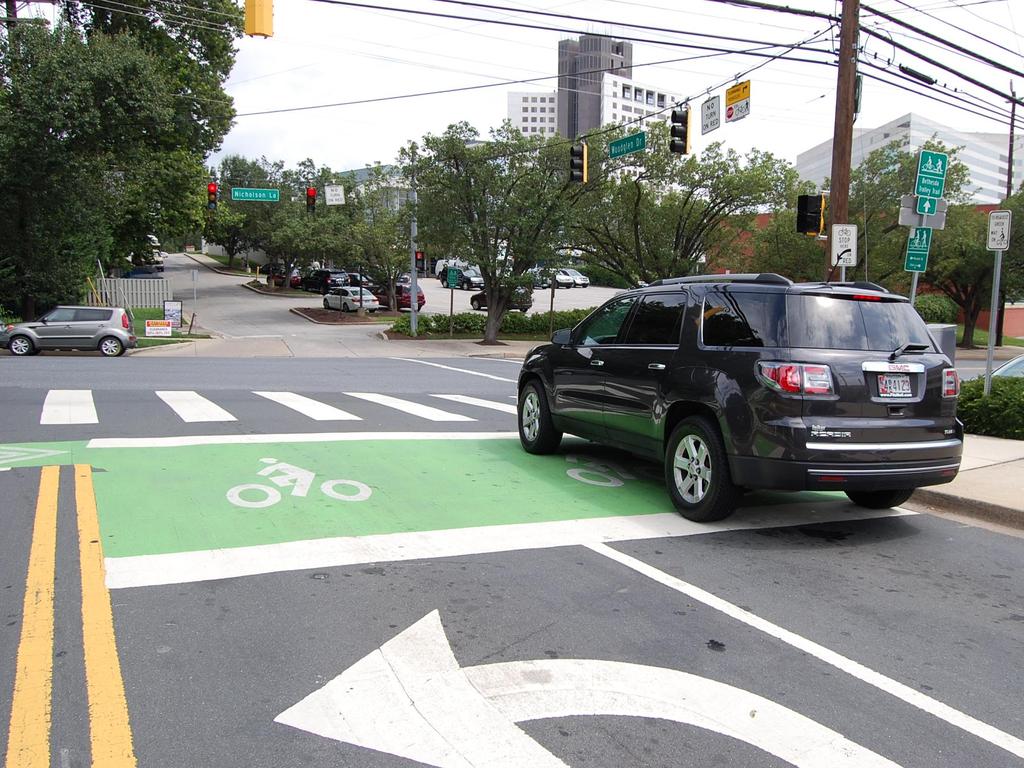
16 SEPARATED BIKE LANE A bikeway that is physically separated from motor vehicles and pedestrian facilities. The separation may be vertical, such as a curb; horizontal, such as a landscape panel or parking lane; or a combination. A separated bike lane may be in a one-way or twoway configuration. Two-Way Separated Bike Lanes on Woodglen Drive, White Flint Status in Montgomery County Existing: 0.3 miles Master 16 Plan: 7.7 miles Existing Master-Planned*

 existing bike facilities that are not recommended in previous master plans, and 2) some")
17 SHARED USE PATH A paved path that is typically 10 feet wide but can vary between 8 feet and 14 feet wide, designated for bicycles and pedestrians, that is separated from motorized traffic by a curb, barrier, or landscape panel. They can be constructed as: Sidepaths when they are within the road right-of-way, such as along MacArthur Blvd Trails when they are in an independent right-of-way, such as the North Bethesda Trail MacArthur Blvd Sidepath North Bethesda Trail Existing * Does not include: 1) existing bike facilities that are not recommended in previous master plans, and 2) some bikeways recommended in Rockville and Gaithersburg master plans Status in Montgomery County Existing: 175 miles Master Plan: 401 miles Master-Planned* 17
18 INTERSECTIONS

19 BIKE BOX A designated area at the head of a traffic lane at a signalized intersection that provides bicyclists a safe and visible way to get ahead of queuing traffic during the red signal phase. Woodglen Drive, White Flint 19

20 TWO-STAGE QUEUE BOX An intersection treatment that facilitates left turns at multi-lane intersections from a standard bike lane or separated bike lane on the right side of the road. Broadway, Seattle Status in Montgomery County Existing: 20 0

21 WAYFINDING AND MARKINGS

22 DIRECTIONAL SIGNAGE Signs that provide wayfinding for cyclists. North Bethesda Trail, White Flint 22

23 SHARED ROADWAY MARKINGS A road markings used to indicate a shared lane environment for bicycles and automobiles. Among other benefits shared lane markings reinforce the legitimacy of bicycle traffic on the street, recommend proper bicyclist positioning, and may be configured to offer directional and wayfinding guidance. Also known as sharrows. Second Avenue in Silver Spring 23
24 BIKE PARKING

25 SHORT-TERM BICYCLE PARKING Bicycle parking that is generally intended for patrons and visitors. These spaces are generally associated with retail and civic uses, which have higher turnover rates than residential and employment uses. A branded bike rack along the North Bethesda Trail A standard bike rack in Silver Spring 25


26 SHORT-TERM BIKE PARKING REQUIREMENTS FOR SITE PLANS Chapter 59, Section B of the Montgomery County Code Intended for patrons and visitors. Each short term bicycle parking space must be: available to the public; located in a convenient, well lit area that is clearly visible to both a visitor to the building and a person who is on the sidewalk that accesses the building s main entrance; and within 90 feet from: the main entrance of any building; or at least one main entrance of a building with more than one main entrance; unless the applicable deciding body approves an alternative location during the site plan or conditional use process. Takoma Park Library 26


27 LONG-TERM BICYCLE PARKING Bicycle parking that is generally intended for residents and employees. These spaces are generally associated with residential and employment uses. Examples are bike cages, bike rooms, and bike lockers. Bike Lockers at the Silver Spring Metrorail Station Residential Bike Room at Fenwick Station Apartments, Silver Spring 27
28 LONG-TERM BIKE PARKING REQUIREMENTS FOR SITE PLANS Chapter 59, Section A of the Montgomery County Code Intended for residents and employees. Must be provided within a building, covered parking garage, or bicycle locker located near the building or structure and the street or other bicycle right of way. Must be accessible for all building tenants during the building's hours of operations. A long term bicycle parking space in a garage: must be located no lower than the first complete parking level below grade, and no higher than the first complete parking level above grade must be in a well lit, visible location near the main entrance or elevators If a long term bicycle parking space is in an enclosed area, the facility must not be accessible to anyone without authorized access. 28
29 Bicycle Supportive Facilities Showers & Changing Facilities Any individual tenant space with more than 50,000 square feet of nonresidential gross floor area (excluding retail or uses with less than 50 employees during the largest shift), must have one shower changing facility for each gender, unless the development has shower and changing facilities in a common area that is available to all tenants. One additional shower and changing facility per gender must be installed for every additional 50,000 square feet of nonresidential gross floor area (excluding retail), up to a maximum of 3 for each gender. Lockers If a long term bicycle storage facility is required for a nonresidential use, the facility must have a minimum of 0.3 clothing lockers for each required long term storage space for each gender. 29

30 BICYCLE TRANSIT CENTERS / BIKE STATIONS A secure and covered bicycle parking facility that can include amenities such as showers, changing rooms, lockers, bicycle repair, and bicycle rental. Bicycle stations are often located at transit stations. Union Station Bike Station, Washington, DC 30
31 METRO STATIONS WITH THE MOST/FEWEST BIKES PARKED Most Bikes Parked Fewest Bikes Parked 1 Bethesda 1 Wheaton 2 Medical Center 2 White Flint Friendship Heights 3 Forest Glen 4 Twinbrook 4 Glenmont 5 Silver Spring 5 Rockville 1 Bethesda 1 White Flint 2 Grosvenor 2 Glenmont Twinbrook 3 Forest Glen 4 Silver Spring 4 Wheaton 5 (t) Friendship Heights & Shady Grove 5 Rockville 1 Silver Spring 1 Wheaton 2 (t) Bethesda 2 White Flint (t) Shady Grove 3 Glenmont 4 Grosvenor 4 Forest Glen 5 (t) Medical Center & Rockville 5 Friendship Heights 1 Twinbrook 1 Wheaton 2 Grosvenor 2 White Flint (t) Bethesda 3 Friendship Heights 3 (t) Silver Spring 4 Glenmont 5 Rockville 5 Shady Grove Source: WMATA Bicycle Parking Census,

32 CAPITAL BIKESHARE

33 BIKESHARE A service in which bicycles are made available for shared use, allowing people to borrow a bike from one location and return it to another. Spring Street & First Street, Silver Spring 33


34 BIKESHARE OVERVIEW Overview Montgomery County launched in Sept Stations in Montgomery County Montgomery County Service Areas Takoma Park Silver Spring Friendship Heights Bethesda Rockville Shady Grove 34
35 BIKESHARE STATISTICS Interesting stats Source: Capital Bikeshare 35
36 MOST USED COUNTY BIKESHARE STATIONS: 2014 TRIP ORIGINS Rank Station Service Area Average Trips per Day 1 Bethesda Metro Station Bethesda Friendship Heights Metro Station Friendship Heights Bethesda Avenue & Arlington Road Bethesda Carroll Avenue & Ethan Allen Avenue Takoma Park River Road & Landy Lane Westbard Shady Grove Metro Station Shady Grove Battery Lane & Trolley Trail Bethesda Carroll Avenue & Westmoreland Avenue Takoma Park Montgomery Lane & East Lane Bethesda Cordell Avenue & Norfolk Avenue Bethesda Source: Capital Bikeshare
37 MOST Most USED Heavily COUNTY Used BIKESHARE Stations STATIONS: 2014 TRIP DESTINATIONS Rank Station Service Area Average Trips per Day 1 Bethesda Metro Station Bethesda Bethesda Avenue & Arlington Road Bethesda Friendship Heights Metro Station Friendship Heights Carroll Avenue & Ethan Allen Avenue Takoma Park River Road & Landy Lane Westbard Maple Avenue & Ritchie Avenue Takoma Park Philadelphia Avenue & Maple Avenue Takoma Park Cordell Avenue & Norfolk Avenue Bethesda Battery Lane & Trolley Trail Bethesda Offutt Lane & Chevy Chase Drive Bethesda 3.4 Source: Capital Bikeshare 37
38 MOST POPULAR MONTGOMERY COUNTY BIKESHARE 2014 TRIP PAIRS Rank Station One Station Two # of Trips % of County Trips in Takoma Metro Station Carroll Avenue & Ethan Allen Avenue 2, % 2 Takoma Metro Station Maple Avenue & Ritchie Avenue 1, % 3 Takoma Metro Station Philadelphia Avenue & Maple Avenue 1, % 4 Takoma Metro Station Fenton Street & New York Avenue 1, % 5 Carroll Avenue & Ethan Allen Avenue Carroll Avenue & Westmoreland Avenue % 6 Bethesda Metro Station Cordell Avenue & Norfolk Avenue % 7 Takoma Metro Station Carroll Avenue & Westmoreland Avenue % 8 Battery Lane & Trolley Trail Norfolk Avenue & Fairmont Street % 9 Shady Grove Metro Station King Farm Boulevard & Pleasant Drive % 10 Bethesda Avenue & Arlington Road Bethesda Avenue & Arlington Road % 38 Source: Capital Bikeshare

39 AVERAGE DAILY COUNTY BIKESHARE TRIPS IN 2014 Source: Capital Bikeshare 39

40 MONTHLY COUNTY BIKESHARE TRIPS IN Source: Capital Bikeshare

41 CAPITAL CRESCENT TRAIL


42 COUNT LOCATIONS Bethesda Ave Opened 11/13/ yards south of Bethesda Avenue MacArthur Blvd Opened 2/11/ yards south of Dalecarlia Tunnel 42

43 Bicyclists TOTAL CCT by Month USERS PER MONTH Bethesda Ave MacArthur Blvd January * February * March April May June * MacArthur Blvd counter began operating on Feb 11,

44 Bicyclists AVERAGE by CCT Day of USERS Week PER DAY Bethesda Ave MacArthur Blvd Sunday Monday Tuesday Wednesday Thursday Friday Saturday 44 * MacArthur Blvd counter began operating on Feb 11, 2015
45 Bicyclists AVERAGE by CCT Time USERS of Day PER HOUR 45
46 SAFETY

47 REPORTED Bicyclists by BICYCLE Time of Day COLLISIONS BY YEAR Sources: Montgomery County Police Department, Montgomery County CountyStat, American Community Survey, One-Year Samples 47
48 REPORTED Bicyclists by BICYCLE Time of Day COLLISIONS BY MONTH 48 Sources: Montgomery County Police Department, Montgomery County CountyStat

49 BICYCLE Bicyclists COLLISIONS by Time of Day BY TIME OF DAY Sources: Montgomery County Police Department, Montgomery County CountyStat,

50 PLANNING TOOLS

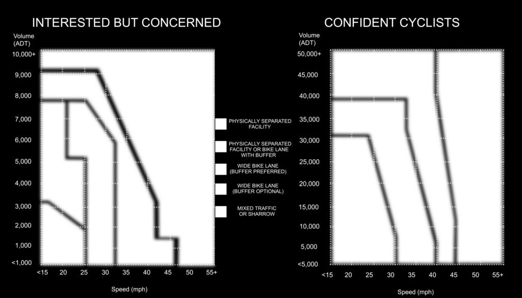
51 WHAT IS TRAFFIC STRESS? When cyclists travel along roadways, they face varying levels of stress from traffic. A quiet residential street with a 25-mile-per-hour speed limit presents a low-stress setting for cyclists, but a six-lane highway with a 40-mileper-hour speed limit creates a high-stress environment for cyclists who must share the roadway with traffic. Stress from traffic is affected by variables such as traffic speed, traffic volume, number of lanes, frequency of parking turnover and ease of crossing intersection, among other things. People are more likely to bicycle in low-stress environments, so improving bicycling in Montgomery County requires developing lowstress connections between activity centers, transit facilities and neighborhoods. Rockville Pike is a high stress bicycling environment The Bicycle Master Plan will use a modified version of the Level of Traffic Stress developed by Peter Furth at Northeastern University. 51

52 52 NOMOGRAPHS: SPEED AND VOLUME CHARTS
53 CONNECT WITH THE BICYCLE MASTER PLAN Website Montgomeryplanning.org/bikeplan 53
54
MONTGOMERY COUNTY PLANNING DEPARTMENT THE MARYLAND-NATIONAL CAPITAL PARK AND PLANNING COMMISSION
 MONTGOMERY COUNTY PLANNING DEPARTMENT THE MARYLAND-NATIONAL CAPITAL PARK AND PLANNING COMMISSION MCPB Item No. 4 Date: 09-10-15 Scope of Work for the Bicycle Master Plan David Anspacher, Planner/Coordinator,
Proposed White Flint Separated Bike Lane Network September 2015
 Proposed White Flint Separated Bike Lane Network September 2015 Abstract This report includes a proposed separated bike lane network for the White Flint Sector Plan area. Separated bike lanes create a
MONTGOMERY COUNTY COUNCIL
 MONTGOMERY COUNTY COUNCIL R O C K V I L L E, M A R Y L A N D October 20, 2015 The Honorable Isiah Leggett Montgomery County Executive 101 Monroe Street, 2nd Floor Rockville, MD 20850 Dear County Executive
Color your stress away
 Color your stress away Learn about the Bicycle Master Plan s comfortable, low-stress bicycling network in Montgomery County. Unwind as you color the bicycling scenes. Check out montgomeryplanning.org/bikeplan
MONTGOMERY COUNTY PLANNING DEPARTMENT THE MARYLAND-NATIONAL CAPITAL PARK AND PLANNING COMMISSION
 MONTGOMERY COUNTY PLANNING DEPARTMENT THE MARYLAND-NATIONAL CAPITAL PARK AND PLANNING COMMISSION MCPB Item No. 5 Date: 12/3/15 Draft White Flint Separated Bike Lanes Network David Anspacher, Functional
Rolling Out New Bike Facilities Within the North Bethesda & White Flint Area
 Rolling Out New Bike Facilities Within the North Bethesda & White Flint Area Rolling Out New Bike Facilities Within the North Bethesda & White Flint Area Agenda Designing for all Cyclists Background on
The Nexus between Transportation Demand Your sub title Management (TDM), Transit Station Access, and Internal Station Circulation
, Transit Station Access, and Internal Station Circulation") YOUR LINKING TITLE THE LINKS The Nexus between Transportation Demand Your sub title Management (TDM), Transit Station Access, and Internal Station Circulation Presentation Makeover Montgomery Location
YOUR LINKING TITLE THE LINKS The Nexus between Transportation Demand Your sub title Management (TDM), Transit Station Access, and Internal Station Circulation Presentation Makeover Montgomery Location
Bicycle Facilities Planning
 Bicycle Facilities Planning Overview Types of Cyclists Purpose for Riding Types of Facilities Bike Lanes Bicycle Boulevards Cycle Tracks Intersections Signals Signing and Marking Discussion Types of Bicyclists
SHIFTING GEARS. for a better ride ahead. MONTGOMERY COUNTY DEPARTMENT OF TRANSPORTATION April 5, 2014
 SHIFTING GEARS for a better ride ahead MONTGOMERY COUNTY DEPARTMENT OF TRANSPORTATION April 5, 2014 CYCLING IN THE USA The number of bicyclists is growing rapidly in the United States Transportation &
Appendix G: Bicycle Parking Space Recommendations at Transit Stations
 Appendix G: Bicycle Parking Space Recommendations at Transit Stations Bicycle parking is needed at all Metrorail Red Line, MARC, Purple Line and Corridor Cities Transitway stations. This appendix includes
Watertown Complete Streets Prioritization Plan. Public Meeting #1 December 14, 2017
 Watertown Complete Streets Prioritization Plan Public Meeting #1 December 14, 2017 Goals for Public Meeting Overview of MassDOT Complete Streets Funding Program Educate the community on Complete Streets
APPENDIX E BIKEWAY PRIORITIZATION METHODOLOGY
 APPENDIX E BIKEWAY PRIORITIZATION METHODOLOGY INTRODUCTION The network of bikeways recommended in the Bicycle Master Plan is extensive and is likely to be only partially completed during the 25-year life
NM-POLICY 1: Improve service levels, participation, and options for non-motorized transportation modes throughout the County.
 Transportation PRINCE WILLIAM COUNTY 2008 COMPREHENSIVE PLAN NON-MOTORIZED PLAN CONTENTS Goals, Policies, and Action Strategies Table 4 (Bike Facility Classifications and Descriptions) Table 5 (Bike Facility
Chapter 2. Bellingham Bicycle Master Plan Chapter 2: Policies and Actions
 Chapter 2 Bellingham Bicycle Master Plan Chapter 2: Policies and Actions Chapter 2: Policies and Actions The Bicycle Master Plan provides a road map for making bicycling in Bellingham a viable transportation
Active Transportation Facility Glossary
 Active Transportation Facility Glossary This document defines different active transportation facilities and suggests appropriate corridor types. Click on a facility type to jump to its definition. Bike
Introduction. Using the Checklist. TDM-Supportive Development Design and Infrastructure Checklist Version 1.0 (30 June 2017) City of Ottawa
 City of Ottawa") Introduction The s Transportation Impact Assessment (TIA) Guidelines (specifically Module 4.1 Development Design) requires proponents of qualifying developments to use the City s TDM-Supportive Development
Introduction The s Transportation Impact Assessment (TIA) Guidelines (specifically Module 4.1 Development Design) requires proponents of qualifying developments to use the City s TDM-Supportive Development
Table #6 VISION CHARACTERISTICS
 Table #6 VISION White Flint is a place to live, work, play, shop, and walk with sufficient density to encourage quality redevelopment. Vibrant streets and consistent streetscapes are important. CHARACTERISTICS
MONTGOMERY COUNTY PLANNING DEPARTMENT THE MARYLAND-NATIONAL CAPITAL PARK AND PLANNING COMMISSION
 MONTGOMERY COUNTY PLANNING DEPARTMENT THE MARYLAND-NATIONAL CAPITAL PARK AND PLANNING COMMISSION Bicycle Master Plan Community Advisory Group Members MCPB Item No. 8 Date: 11/19/15 David Anspacher, Functional
G AT E WAY PLAN. Community BRIEFING KIT GATEWAY BIKE
 G AT E WAY PLAN GATEWAY BIKE Community BRIEFING KIT PLAN August 2016 TABLE OF CONTENTS INTRODUCTION... 1 THE BENEFITS OF A BIKEABLE COMMUNITY... 2 ECONOMY...2 SAFETY...3 HEALTH...3 HOUSEHOLD SPENDING...3
Prioritization of Bicycle Supportive Laws, Regulations and Policies. Recommended Expanded Bicycle-Supportive Programs
 1) Table of Contents, Add these subsections: s Bicycle Facility Classifications General Application Breezeway Network Recommendations Bicycle Parking Short-Term Bicycle Parking Long-Term Bicycle Parking
Board-Approved Funding Awards for Cycle 4 Active Transportation Grant Program Projects (in Order of Project Rankings) Approved on
 Approved on") CAPITAL Large Category Projects Board-Approved Funding Awards for Cycle 4 Active Transportation Grant Program Projects (in Order of Project Rankings) Approved on 07-27-18 1 La Mesa University Ave Pedestrian
CAPITAL Large Category Projects Board-Approved Funding Awards for Cycle 4 Active Transportation Grant Program Projects (in Order of Project Rankings) Approved on 07-27-18 1 La Mesa University Ave Pedestrian
2014 Mobility Assessment Report Functional Planning & Policy Montgomery County Planning Department
 2014 Mobility Assessment Report Functional Planning & Policy Montgomery County Planning Department Travel Trends National & Local Travel Trends Multi-Modal Monitoring Pedestrian Bikes Bus Rail Future Efforts
MONTGOMERY COUNTY COUNCIL MEMORANDUM
 MONTGOMERY COUNTY COUNCIL R O C K V I L L E, M A R Y L A N D HANS RIEMER COUNCILMEMBER AT-LARGE MEMORANDUM To: T&E Committee From: Councilmember Hans Riemer Date: March 1, 2016 Re: Funding a Protected
City Snapshot September 27, 2018
 1 City Snapshot September 27, 2018 Respondent Introduction Thank you for providing data for the PlacesForBikes City Rating program! The information you provide will be used to understand the progress your
REGIONAL BICYCLE AND PEDESTRIAN DESIGN GUIDELINES
 REGIONAL BICYCLE AND PEDESTRIAN DESIGN GUIDELINES November 16, 2011 Deb Humphreys North Central Texas Council of Governments Bicycle and Pedestrian Advisory Committee Snapshot of the Guide 1. Introduction
El Centro Mobility Hub
 The El Centro drive shed comprises a major portion of the El Centro downtown area, which is well served by bus routes. The proposals intend to promote use of public transit through improvements and enhancements
Omaha s Complete Streets Policy
 Omaha s Complete Streets Policy (Adopted August 2015) VISION To create great places and enhance our quality of life, the City of Omaha will provide safe, accessible streets for all users. Complete Streets
LANCASTER CITY BICYCLE NETWORK
 LANCASTER CITY BICYCLE NETWORK Downtown Merchants Meeting Wednesday, July 19, 2017 http://www.lancasteratp. DOWNTOWN WALKABILITY ANALYSIS What changes can be made, in the least amount of time, and for
CPC Parking Lot Riverside Drive. Transportation Rationale
 CPC Parking Lot Transportation Rationale Prepared By: NOVATECH Suite 200, 240 Michael Cowpland Drive Ottawa, Ontario K2M 1P6 September 2015 Novatech File: 114093 Ref: R-2015-153 Table of Contents 1.0 INTRODUCTION...
Multimodal Through Corridors and Placemaking Corridors
 68 Multimodal Through Corridors and Placemaking Corridors Corridors have different functions in a region. Some corridors are used to get smoothly and rapidly through a region or to get quickly to major
Cycle Track Design Best Practices Cycle Track Sections
 Design Best Practices Sections It is along street segments where the separation and protection methods of cycle tracks offer more comfort than conventional bicycle lanes, and are more attractive to a wide
Solana Beach Comprehensive Active Transportation Strategy (CATS)
") Solana Beach Comprehensive Active Transportation Strategy (CATS) 3.0 Goals & Policies The Solana Beach CATS goals and objectives outlined below were largely drawn from the Solana Beach Circulation Element
Solana Beach Comprehensive Active Transportation Strategy (CATS) 3.0 Goals & Policies The Solana Beach CATS goals and objectives outlined below were largely drawn from the Solana Beach Circulation Element
Prince George s County plans, policies, and projects
 Prince George s County plans, policies, and projects Over 250 projects for trails, bikeways, designated bike lanes and sidewalk construction Trail projects that improve access to Metro Sidewalk and trail
Hennepin County Bicycle and Pedestrian Planning
 Hennepin County Bicycle and Pedestrian Planning 1 Value of bicycle and sidewalk systems Safety Livability Mobility Health Personal Finances Economic Sustainability Clean Air Recreation Parking and congestion
CONNECTING PEOPLE TO PLACES
 CONNECTING PEOPLE TO PLACES 82 EAST BENCH MASTER PLAN 07 Introduction The East Bench transportation system is a collection of slow moving, treelined residential streets and major arteries that are the
Agenda. Overview PRINCE GEORGE S PLAZA METRO AREA PEDESTRIAN PLAN
 PRINCE GEORGE S PLAZA METRO AREA PEDESTRIAN PLAN May 28, 2008 Agenda Welcome and introductions Project overview and issue identification Planning context and strengths Design challenges and initial recommendations
MTP BICYCLE ELEMENT UPDATE. November 2017
 MTP BICYCLE ELEMENT UPDATE November 2017 TIME FOR AN UPDATE Bicycle Element adopted in July 2008 Almost 10 years old Many planned facilities have been implemented 10 years more experience in planning,
Fitting Light Rail through Well-established Communities
 Fitting Light Rail through Well-established Communities San Francisco 2008 Michael D. Madden Chief, Project Development, Maryland Transit Administration Project Setting Located inside the Capital Beltway
9/25/2018. Multi-Modal Level of Service (MMLOS) Bianca Popescu, Transportation Planner
 Bianca Popescu, Transportation Planner") Multi-Modal Level of Service (MMLOS) Bianca Popescu, Transportation Planner 1 What is MMLOS? Is this a nice place to walk? Is this a nice place to bike? Is transit convenient? Bottom line - Are there options
Multi-Modal Level of Service (MMLOS) Bianca Popescu, Transportation Planner 1 What is MMLOS? Is this a nice place to walk? Is this a nice place to bike? Is transit convenient? Bottom line - Are there options
Development of Arlington County s Marked Crosswalk Guidelines. Jon Lawler, P.E. Design Engineer Arlington County, VA
 Development of Arlington County s Marked Crosswalk Guidelines Jon Lawler, P.E. Design Engineer Arlington County, VA April 13, 2015 Transportation System Users Residents Estimated 215,000 in 2014 Lowest
5. RUNNINGWAY GUIDELINES
 5. RUNNINGWAY GUIDELINES These guidelines should be considered collectively when making runningway decisions. A runningway is the linear component of the transit system that forms the right-of-way reserved
APPENDIX D LEVEL OF TRAFFIC STRESS METHODOLOGY
 APPENDIX D LEVEL OF TRAFFIC STRESS METHODOLOGY 01 WHAT IS LEVEL OF TRAFFIC STRESS? When people bicycle on roadways, they encounter varying levels of stress from traffic. A quiet residential street with
Presentation of Staff Draft March 18, 2013 COUNTYWIDE TRANSIT CORRIDORS FUNCTIONAL MASTER PLAN
 Presentation of Staff Draft March 18, 2013 COUNTYWIDE TRANSIT CORRIDORS FUNCTIONAL MASTER PLAN Public Outreach Fall 2011: Two community meetings/open houses Fall 2012: Three community meetings/open houses
Bicycle and Pedestrian Access in Transit Oriented Developments. Bruce Wright Chairman, Fairfax Advocates for Better Bicycling April, 2009
 Bicycle and Pedestrian Access in Transit Oriented Developments Bruce Wright Chairman, Fairfax Advocates for Better Bicycling April, 2009 Overview Reasons to encourage bicycling Compare bike and walk distances
2.0 LANE WIDTHS GUIDELINE
 2.0 LANE WIDTHS GUIDELINE Road Engineering Design Guidelines Version 2.0.1 May 2018 City of Toronto, Transportation Services City of Toronto Page 0 Background In early 2014, Transportation Services initiated
Countywide Transit Corridors Functional Master Plan
 Countywide Transit Corridors Functional Master Plan Makeover Montgomery II May 10, 2014 Master Plan Status Begun: August 2011 Planning Board Approved Draft Plan: July 2013 Council Approved Final Plan:
Chapter 9: Pedestrians and Bicyclists
 Chapter 9: Pedestrians and Bicyclists Walking and bicycling are essential modes of transportation. These modes allow people to travel without contributing to congestion and air pollution, to access other
FY Transportation Capital Improvement Plan Update Arlington Committee for Transportation Choices
 FY 2017-2026 Transportation Capital Improvement Plan Update Arlington Committee for Transportation Choices November 1, 2017 Forecasted Growth Arlington continues to grow with a shift towards multi-family
MONTGOMERY COUNTY PLANNING DEPARTMENT THE MARYLAND-NATIONAL CAPITAL PARK AND PLANNING COMMISSION
 MONTGOMERY COUNTY PLANNING DEPARTMENT THE MARYLAND-NATIONAL CAPITAL PARK AND PLANNING COMMISSION MCPB Item No. 4 Date: 04-17-14 2014 Mobility Assessment Report José Dory, Senior Planner, Functional Planning
Bus Rapid Transit Plans
 Twin Cities Region Bus Rapid Transit Plans ULI Minnesota Workshop Connecting Bus Rapid Transit to the Community December 15, 2009 John Levin Director of Service Development Metro Transit Metropolitan Area
MASTER BICYCLE AND PEDESTRIAN PLAN
 VILLAGE OF NORTHBROOK MASTER BICYCLE AND PEDESTRIAN PLAN DRAFT PLAN OPEN HOUSE May 2, 2018 AGENDA 1. Community Engagement 2. Vision and Goals 3. General Structure of Plan 4. Recommendations Overview 5.
MONTGOMERY COUNTY PLANNING DEPARTMENT
 MONTGOMERY COUNTY PLANNING DEPARTMENT THE MARYLAND-NATIONAL CAPITAL PARK AND PLANNING COMMISSION Veirs Mill Corridor Master Plan: Work Session #5 MCPB Item No. Date: 10/04/18 Jessica McVary, Planner Coordinator,
Toronto Complete Streets Guidelines
 88 90 5.1 Cycling Design Principles 92 5.2 Context-sensitive Cycling Facilities 96 5.3 Key Cycling Elements Cycling infrastructure provides choice in how people are able to move around the city. Cyclists
2. Vision & Goals. Vision. Santa Rosa is a community where walking and bicycling are comfortable and convenient for people of all ages and abilities.
 2. Vision & Goals Overview The goals of the Santa Rosa Bicycle and Pedestrian Master Plan Update reflect the priorities expressed by the community throughout the public outreach phase of this Plan Update.
Beyond First First Last Last Mile Strategies. APA National Conference April 3, 2016 Chelsea Richer, AICP Fehr & Peers
 Beyond First First Last Last Mile Strategies APA National Conference April 3, 2016 Chelsea Richer, AICP Fehr & Peers 1 Beyond First Last Mile Strategies APA National Conference Jeremy Klop, AICP, Fehr
C C C
 C-012-001 Thank you for your support for the creation of new public space and nonmotorized access between downtown and the waterfront through the Overlook Walk, the East-West Connections, and the Promenade.
Broad Street Bicycle Boulevard Design Guidelines
 Broad Street Bicycle Boulevard Design Guidelines Building from the strategies introduced in the 2013 Bicycle Transportation Plan and community input received thus far, City Transportation Staff have identified
Short-Term Enhancements Improvements to keep Austin moving. MetroRapid
 Short-Term Enhancements Improvements to keep Austin moving Long-Term Investments Projects to support our future Mobility Hubs MetroRapid MetroRail MetroExpress Commuters Connectors Circulators Project
Rapid Transit in Montgomery County
 Rapid Transit in Montgomery County Montgomery County Department of Transportation Al Roshdieh, Acting Director 1 Background Corridors in Detail Corridor Cities Transitway MD 355 (Bethesda to Rockville
Duwamish Way-finding and CTR Report
 V. North Tukwila When the North Tukwila Manufacturing and Industrial Center was designated in 1992 as part of the region s land use and transportation plan, the plan called for the area to set a light-rail
Small Town & Rural Multimodal Networks
 Small Town & Rural Multimodal Networks Fred Young, PLA Andrea Clinkscales, AICP, PMP Alta Planning + Design Funding Partners Project Team Existing Design Guidance AASHTO Flexibility Guide 2004 AASHTO Bike
4 MOBILITY PLAN. Mobility Plan Objectives. Mobility Context. 1. Integrate with Local and Regional Transit Improvements
 Harbor Mixed Use CHAPTER Transit Corridor 4: Mobility Plan 4 MOBILITY PLAN Mobility Plan Objectives The Harbor Corridor Plan seeks to expand and improve the ways that people move along and through the
PRINCE GEORGE S PLAZA METRO AREA PEDESTRIAN PLAN
 PRINCE GEORGE S PLAZA METRO AREA PEDESTRIAN PLAN May 28, 2008 Agenda Welcome and introductions Project overview and issue identification Planning context and strengths Design challenges and initial recommendations
Who is Toole Design Group?
 2018 AASHTO Bike Guide Status Update NCHRP 15 60 Amalia Leighton Cody, PE, AICP & Kenneth Loen, PE Washington APWA October 4, 2018 Who is Toole Design Group? TDG is a full service engineering, planning
Off-road Trails. Guidance
 Off-road Trails Off-road trails are shared use paths located on an independent alignment that provide two-way travel for people walking, bicycling, and other non-motorized users. Trails specifically along
Planning Suburban Bike Networks
 Planning Suburban Bike Networks Stacey Meekins, AICP 28 October, 2015 Bikeway design guidance Different Cyclists Have Different Needs No interest 33% Strong and Fearless 1% Enthused and Confident 7% Interested,
Chapter 7. Transportation. Transportation Road Network Plan Transit Cyclists Pedestrians Multi-Use and Equestrian Trails
 Chapter 7 Transportation Transportation Road Network Plan Transit Cyclists Pedestrians Multi-Use and Equestrian Trails 7.1 TRANSPORTATION BACKGROUND The District of Maple Ridge faces a number of unique
Proposed Bridge Street East Bicycle Lanes Public Open House Thursday, April 27, 2017
 WELCOME Proposed Bridge Street East Bicycle Lanes Public Open House Thursday, April 27, 2017 Purpose of the Open House The purpose of this Open House is to gain public input on the bicycle lanes proposed
Montgomery County Bicycle Master Plan
 Montgomery County Bicycle Master Plan Great Seneca Science Corridor Implementation Advisory Committee March 26, 2015 1 BICYCLE MASTER PLAN Purpose Bring recommendations in line with current best practices
Cluster 5/Module 2 (C5/M2): Pedestrians and Transit Oriented Development (TOD)
: Pedestrians and Transit Oriented Development (TOD)") 1 Cluster 5/Module 2 (C5/M2): Pedestrians and Transit Oriented Development (TOD) This presentation is one of the support materials prepared for the capacity building program Building Leaders in Urban Transport
1 Cluster 5/Module 2 (C5/M2): Pedestrians and Transit Oriented Development (TOD) This presentation is one of the support materials prepared for the capacity building program Building Leaders in Urban Transport
METRO RTA TRANSIT MASTER PLAN. May 25-26, 2011
 METRO RTA TRANSIT MASTER PLAN May 25-26, 2011 WHAT IS THE TRANSIT MASTER PLAN? A twenty-year plan for METRO RTA What will METRO look like in 2031? 1 TRANSIT TECHNOLOGIES 2 TRANSIT TECHNOLOGIES Transit
TRAFFIC CALMING GUIDE FOR TORONTO CITY OF TORONTO TRANSPORTATION SERVICES DIVISION
 TRAFFIC CALMING GUIDE FOR TORONTO CITY OF TORONTO TRANSPORTATION SERVICES DIVISION CITY OF TORONTO TRANSPORTATION SERVICES DIVISION 2016 TRAFFIC CALMING GUIDE FOR TORONTO TABLE OF CONTENTS Introduction
TRANSPORTATION & MOBILITY
 TRANSPORTATION & MOBILITY ROADWAY SYSTEM There are approximately 40 miles of roadways in Manitou Springs. For planning purposes, roadways are typically assigned a functional classification which defines
Bikeway action plan. Bicycle Friendly Community Workshop March 5, 2007 Rochester, MN
 Bikeway action plan Summary The was held on March 5, 2007 at the Rochester Mayo Civic Center. The workshop was hosted by Rochester-Olmsted County Planning Department in collaboration with the League of
Connecting cyclists to work. Syracuse Metropolitan Transportation Council
 Connecting cyclists to work Syracuse Metropolitan Transportation Council Overview Prepared at request: NYS Department of Transportation (NYSDOT) Project Achievements Target group Purpose Process Recommendations
Appendix D. City of Fort Collins Bicycle Wayfinding System Guidance. Appendix D: Bicycle Wayfinding System Guidance Final Draft 11/20/2014 1
 Appendix D City of Fort Collins Bicycle Wayfinding System Guidance Appendix D: Bicycle Wayfinding System Guidance Final Draft 11/20/2014 1 1 -- Introduction A network of signed bicycle routes will contribute
Transportation. Pages E-3 to E-145 PROPOSED FY CAPITAL IMPROVEMENT PLAN (CIP) CCCRC Presentation Thursday, June 14, 2018
 CCCRC Presentation Thursday, June 14, 2018") PROPOSED FY 2019-2028 CAPITAL IMPROVEMENT PLAN (CIP) Pages E-3 to E-145 CCCRC Presentation Thursday, June 14, 2018 in the CIP Continues Arlington s commitment to a transportation system that expands travel
PROPOSED FY 2019-2028 CAPITAL IMPROVEMENT PLAN (CIP) Pages E-3 to E-145 CCCRC Presentation Thursday, June 14, 2018 in the CIP Continues Arlington s commitment to a transportation system that expands travel
Bicycle and Pedestrian Connectivity Study. Old Colony Planning Council
 Bicycle and Pedestrian Connectivity Study Old Colony Planning Council Outline Why consider bike/peds in road designs? Why are measures needed? Connecting Land Use with Transportation Evaluation Tools:
MASTER BICYCLE AND PEDESTRIAN PLAN
 WELCOME! PLEASE FEEL FREE TO REVIEW THE EXHIBITS THE PRESENTATION WILL BEGIN AT 6:00 PM VILLAGE OF NORTHBROOK MASTER BICYCLE AND PEDESTRIAN PLAN DRAFT EXISTING CONDITIONS REPORT AND PUBLIC MEETING WELCOME!
Rochester Downtown Bicycle Study 2009
 Rochester Downtown Bicycle Study 2009 Relationship of ROCOG Long Range Transportation Plan to Rochester Comprehensive Plan Regional Long Range Transportation Plan (LRTP) is prepared under the auspices
Bicycle Boulevards and Neighborhood Greenways
 Bicycle Boulevards and Neighborhood Greenways Traffic Safety is Improving for Everyone 90 80 70 60 50 40 30 20 10 0 PORTLAND: TOTAL TRAFFIC FATALITIES 1986-2008 1986 1987 1988 1989 1990 1991 1992 1993
Physical Implications of Complete Streets Policies
 Presentation Overview Physical Implications of Complete Norm Cox, ASLA, LLA Landscape Architect Ann Arbor, Michigan, 10:45 to Noon What Are Complete Streets? What Matters to Bicyclists and Pedestrians
Bicycle Master Plan Goals, Strategies, and Policies
 Bicycle Master Plan Goals, Strategies, and Policies Mobilizing 5 This chapter outlines the overarching goals, action statements, and action items Long Beach will take in order to achieve its vision of
This page intentionally left blank.
 This page intentionally left blank. COMMUNITY Coweta Community Overview Coweta Coweta, a residential community located in Wagoner County, is a suburb of Tulsa situated southeast of the metropolitan area
Active Transportation Access to Transit
 Active Transportation Access to Transit Introduction COMO Connect customers access transit service in many ways, including walking, bicycling, riding in a car and being dropped off, and directly boarding
FEDERAL HIGHWAY ADMINISTRATION APPLICATION
 FEDERAL HIGHWAY ADMINISTRATION APPLICATION REQUEST FOR PERMISSION TO EXPERIMENT WITH A BICYCLE BOX INTERSECTION TREATMENT Submitted by: City of Columbus Department of Public Service Date: June 26, 2009
Safe Streets. City of Lake Forest Park. March 21, 2017
 Safe Streets City of Lake Forest Park March 21, 2017 1 01 WELCOME 2 Agenda WELCOME WHAT IS THIS PROJECT? CONTEXT DRAFT CITYWIDE PROJECTS EXERCISE INTRODUCTION 3 02 WHAT IS THIS PROJECT? 4 WHAT IS THIS
Chapter 14 PARLIER RELATIONSHIP TO CITY PLANS AND POLICIES. Recommendations to Improve Pedestrian Safety in the City of Parlier (2014)
") Chapter 14 PARLIER This chapter describes the current status and future plans for biking and walking in the City of Parlier. RELATIONSHIP TO CITY PLANS AND POLICIES The Parlier General Plan is the primary
Chapter 14 PARLIER This chapter describes the current status and future plans for biking and walking in the City of Parlier. RELATIONSHIP TO CITY PLANS AND POLICIES The Parlier General Plan is the primary
Public Information Centre
 WELCOME Public Information Centre Father Tobin Road Lougheed Middle School - Library Wednesday November 7, 2012 7:00 p.m.to 9:00 p.m. Please sign in Neighbourhood Traffic Calming Guide Background The City
CHAPTER 3: Vision Statement and Goals
 Davidson Walks & Rolls: Active Transportation Master Plan CHAPTER 3 Contents: Overview Vision Statement Measurable Goals Public Outreach CHAPTER 3: Vision Statement and Goals Overview The vision statement
Appendix 3 Roadway and Bike/Ped Design Standards
 Appendix 3 Roadway and Bike/Ped Design Standards OTO Transportation Plan 2040 4/20/2017 Page A3-1 Adopted Standards The adopted OTO Design Standards and Major Thoroughfare Plan are contained herein.
Completing the Street: Denning Drive
 Completing the Street: Denning Drive Public Workshop and Walking Audit Winter Park Civic Center May 12, 2016 Completing the Street What Makes This a Complete Street? Completing the Street Complete Streets
Zlatko Krstulich, P.Eng. City of O9awa
 Zlatko Krstulich, P.Eng. City of O9awa 1. Introduction to the Ontario Traffic Manual Series 2. What is OTM Book 18: Bicycle Facilities? 3. Study / Committee Team Members 4. Brief overview of the content
4 Goals, Objectives & Actions
 Chapter4 4 This chapter presents goals, objectives, and recommended actions to support the vision of making Overland Park a safer and easier place to ride a bicycle. 35 4.1 Recommendations Structure The
A Survey of Planning, Design, and Education for Bikeways and Bus Routes on Urban Streets
 A Survey of Planning, Design, and Education for Bikeways and Bus Routes on Urban Streets, Community & Economic Development Agency, Transportation Services Division (510) 238-3983 bikeped@oaklandnet.com
CURBSIDE ACTIVITY DESIGN
 5 CURBSIDE ACTIVITY DESIGN This chapter provides design guidance for separated bike lanes adjacent to curbside activities including parking, loading and bus stops. Typical configurations are presented
7/23/2017 VIA . Michael Hanebutt City of Sacramento Community Development Department 300 Richards Boulevard, 3 rd Floor Sacramento, CA 95811
 7/23/2017 VIA EMAIL Michael Hanebutt City of Sacramento Community Development Department 300 Richards Boulevard, 3 rd Floor Sacramento, CA 95811 RE: 65 th Street Apartments (DR17-220) Dear Mr. Hanebutt:
TRANSPORTATION COMMISSION Agenda Staff Report
 TRANSPORTATION COMMISSION Agenda Staff Report Agenda Item No. 5.a DATE: JULY 31, 2014 TO: FROM: SUBJECT: TRANSPORTATION COMMISSION COMMUNITY DEVELOPMENT DEPARTMENT - PLANNING DRAFT OLYMPIC CORRIDOR PREFERRED
WALKNBIKE DRAFT PLAN NASHVILLE, TENNESSEE EXECUTIVE SUMMARY NASHVILLE, TENNESSEE
 NASHVILLE, TENNESSEE EXECUTIVE SUMMARY Executive Summary A world-class multi-modal transportation system is essential to a vibrant city and better quality of life. -Mayor Barry The WalknBike plan aims
Lessons Learned from Cycle Tracks (Class IV Bikeways) Design Practice
 Design Practice") Lessons Learned from Cycle Tracks (Class IV Bikeways) Design Practice By: Min Zhou, P.E., Principal/Vice President KOA Corporation 1 What is a Cycle Track (Class IV) TYPICAL BIKEWAY CLASSIFICATION CLASS
Lessons Learned from Cycle Tracks (Class IV Bikeways) Design Practice By: Min Zhou, P.E., Principal/Vice President KOA Corporation 1 What is a Cycle Track (Class IV) TYPICAL BIKEWAY CLASSIFICATION CLASS