2014 Mobility Assessment Report Functional Planning & Policy Montgomery County Planning Department
|
|
|
- Abel Blair
- 5 years ago
- Views:
Transcription
1 2014 Mobility Assessment Report Functional Planning & Policy Montgomery County Planning Department
2 Travel Trends National & Local Travel Trends Multi-Modal Monitoring Pedestrian Bikes Bus Rail Future Efforts Overview Intersection Congestion Analysis Critical Lane Volume Intersections Ranked by CLV Intersections By Exceeding Congestion Policy Area Standard Intersection and Roadway Analysis on the ICC Corridor Study In-House Study of Effects of CLVs Roadway Congestion Analysis Measuring Congestion on Roadways Roadway Segment Examples
3 Future Congestion TRAVEL/3 Model Document analysis of barriers and constraints to mobility within Montgomery County. Provide a snapshot of mobility within the County. Inform planning analysis and CIP decision making process. Will continue to pursue further expansion/development of multi-modal measures in next MAR in spring of 2016 Current Congestion Intersection Counts CLV, CLV/LATR Ratios Auto Travel Trends Congestion Performance Measures Mobility Assessment Report CIP Guidance and Planning Tools Transportation Trends Metro Rail Ride On, Metrobus Pedestrian Counts Bike Analysis Vehicle Miles Traveled (VMT)
4 Brief Update: National & Local Travel Trends
5 Percent Change National & Local Travel Trends 3.0% 2.0% 1.0% 0.0% -1.0% -2.0% Nationwide VMT has increased slightly (from ). Vehicle Miles Traveled County VMT has decreased slightly (from )-Stabilized State VMT has increased slightly - Stabilizing Rebounding from the lowest point in % -4.0% Montgomery County Maryland Nation
6 National & Local Travel Trends County VMT has been stabilizing

7 Multi-Modal Monitoring Highlights

8 Multi-Modal Monitoring: In Urban areas, 91 out of 262 intersections have pedestrian counts. Outside of urban areas, there are 171 pedestrian counts that have been collected 42% of intersections in total have pedestrian data in the County Bethesda CBD, Wheaton CBD and Silver Spring CBD all have high pedestrian activity Pedestrian
9 Multi-Modal Monitoring: Bicyclists Planning staff have developed a database platform to support the storage and analysis of bicycle count data. Can analyze turning movements at an intersection, to understand the flow along corridors. Useful for master plans Bike count data represent the least amount of information available for analysis


10 Multi-Modal Monitoring: Bike Analysis Highest Level of Bike Activity is in Bethesda CBD North and South movements are dominant MD 355 in Bethesda CBD
11 Multi-Modal Monitoring: Ride On Heaviest ridership occurs along the 55 and 59 (In Red) which serve Rockville-Gaithersburg Corridor FY 13 has seen an increase from 87,990 in FY 12 to 88,370 riders.

12 Multi-Modal Monitoring: Ride On While over 70% of the routes have peak hour headways between 20 and 30 minutes, more widely used routes like the 55 and 59 have headways of 15 mins or less. Ride-On continues to serve local areas where Metrobus does not serve.
13 75,000 70,000 65,000 60,000 55,000 Multi-Modal Monitoring: Metrobus Ridership WMATA Metrobus Average Ridership Weekday Average Ridership Countywide average weekday ridership increased from 62,062 in FY 12 to 65,794 in FY ,000 FY 10 FY 11 FY 12 FY 13

14 Multi-Modal Monitoring: Metrobus Most heavily traveled routes and with the least amount of time in headways are the C2-C4, J1-3. Continues to serve major corridors rather than local roads.
15 Multi-Modal Monitoring: Metrorail Average Weekday Ridership decreased between FY 11 (173,307) and FY 13 (170,255). Since Recession, recovery of rail ridership has been behind Metrobus Expansion of Telework & AWS 40% of all riders are Federal Employees WMATA Office of Planning 200, , , , , , , , , , ,000 Metrorail Average Weekday Ridership FY 10 FY 11 FY 12 FY 13 Average Weekday Ridership
16 Multi-Modal Monitoring: Metrorail FY '11 Entries 4000 FY '11 Exits FY '13 Entries 4000 FY '13 Exits
17 Multi-Modal Monitoring Continuing Efforts Since 2012, new development applications are required to include a Pedestrian and Bicycle Impact Statement which includes pedestrian and bike count data for Local Area Transportation Review. Planning Department will continue to collect pedestrian and bicycle counts for future analysis. Will investigate new sources like Capital Bikeshare to collect bicycle usage data Will investigate additional sources to analyze rail and bus
18 Intersection Analysis

19 Intersection Analysis 2 Ways in Ranking CLV 1) Regular CLV 2) Applying Policy Area Congestion Standard AM Peak CLV PM Peak CLV
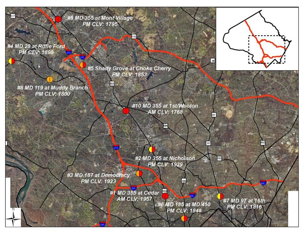
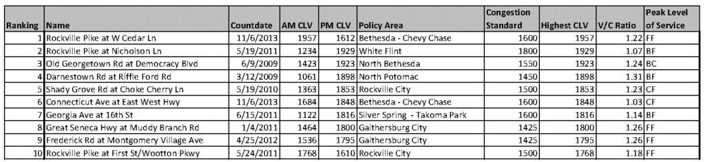
20 Intersections Analysis: By CLV
21 Intersection Analysis: Congestion Exceeding Policy Area Standards In 2011, 83% of intersections in database did not exceed its applicable policy area standard In 2013, 89% of intersections in database did not exceed its applicable policy area standard Since 2005, this is the highest percentage of intersections that are within allowable levels of congestion Rockville, Gaithersburg, and North Bethesda policy areas have the most intersections exceeding their applicable policy area standard

22 Intersection Analysis: Congestion Exceeding Policy Area Standards
23 Intersection & Roadway Analysis on the ICC

24 Intersection & Roadway Analysis on the ICC In 2012, there were 30,000 vehicles per average weekday, and in September 2013, there were 40,000 vehicles. Traffic on MD 200 continues to grow steadily at a rate of 3% per month. Change in Travel Time "Before" and "After" MD 200 Travel Time (Minutes) Via Corridors 1-3 Origin-Destination Pairs Before After Savings Travel Time Savings Via MD 200 (Min) Corridor 1 (S. Gaithersburg to Laurel) (11%) 23 (58%) Corridor 2 (Rockville to Calverton) (5%) 25 (60%) Corridor 3 (S. Rockville to Beltsville) (5%) 21 (55%)
25 Intersection & Roadway Analysis on the ICC The average of the sampled intersection s CLV within the vicinity of the ICC shows a drop of 11% after completion of the ICC Selected Intersections Current Countdate CLV (Pre-ICC) CLV (Post ICC) Percent Change New Hampshire Ave at Norbeck Rd 5/8/ % Norbeck Rd at Layhill Rd 5/1/ % Georgia Ave at Randolph Rd 2/29/ % New Hampshire Ave at Randolph Rd 5/15/ % Georgia Ave at Bel Pre Rd 10/1/ % Norbeck Rd at Wintergate Dr 2/2/ % Norbeck Rd at Bel Pre Rd 2/14/ % Georgia Ave at Norbeck Rd 9/11/ % New Hampshire Ave at Bonifant Rd 2/16/ % Columbia Pk at Fairland Rd 10/11/ % Average Percent Change -10.7%
26 Measuring Congestion on Roadways

27 Measuring Congestion on Roadways What kind of data do we use to monitor roadway congestion? INRIX GPS Probe Data
28 TTI Measuring Congestion on Roadways We display congestion on roadways in 2 ways 1) Using a Travel Time Index Graph TTI Mon 1.6 Tu 1.4 Wed Th 1.2 Fri 1 Sat 12a 2a 4a 6a 8a 10 12p 2p 4p 6p 8p 10 2) Using a Summary Average Congestion Chart Sun
29 Travel Time Index Measuring Congestion on Roadways Travel Time Index Travel Time Index Direction Route Year Policy Area MON TU WED TH FRI SAT SUN 1.1 Free Flow 1 12a 1a 2a 3a 4a 5a 6a 7a 8a 9a 10a 11a 12p 1p 2p 3p 4p 5p 6p 7p 8p 9p 10p 11p
30 Measuring Congestion on Roadways Average Congestion
31 Measuring Congestion on Roadways
32
33
34


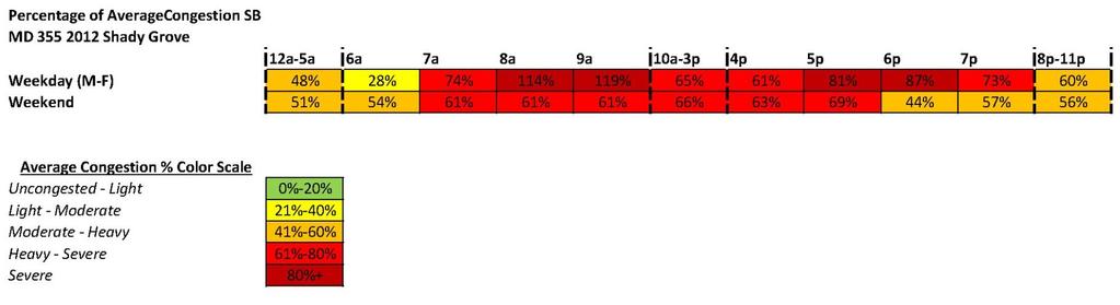
35 Congested Roadways Analysis Of the 120 corridors analyzed, 7 operate under severe congestion levels ranging from 87 to 119 percent. MD 355 southbound in the Shady Grove policy area had the highest congestion level, with congestion above 95 percent and peaking at 119 percent, during morning and evening peaks as well as midday. Six of the top ten most congested corridors are located within the Silver Spring-Takoma Park and Bethesda-Chevy Chase policy areas.

36 Questions? José S Dory Transportation Analyst MNCPPC jose.dory@montgomeryplanning.org
MONTGOMERY COUNTY PLANNING DEPARTMENT THE MARYLAND-NATIONAL CAPITAL PARK AND PLANNING COMMISSION
 MONTGOMERY COUNTY PLANNING DEPARTMENT THE MARYLAND-NATIONAL CAPITAL PARK AND PLANNING COMMISSION MCPB Item No. 4 Date: 04-17-14 2014 Mobility Assessment Report José Dory, Senior Planner, Functional Planning
Countywide Transit Corridors Functional Master Plan
 Countywide Transit Corridors Functional Master Plan Makeover Montgomery II May 10, 2014 Master Plan Status Begun: August 2011 Planning Board Approved Draft Plan: July 2013 Council Approved Final Plan:
Presentation of Staff Draft March 18, 2013 COUNTYWIDE TRANSIT CORRIDORS FUNCTIONAL MASTER PLAN
 Presentation of Staff Draft March 18, 2013 COUNTYWIDE TRANSIT CORRIDORS FUNCTIONAL MASTER PLAN Public Outreach Fall 2011: Two community meetings/open houses Fall 2012: Three community meetings/open houses
Ownership Lots 17 & 18 (Part of Lot 14), Montgomery Auto Sales Park
, Montgomery Auto Sales Park") Traffic Impact Analysis Ownership Lots 17 & 18 (Part of Lot 14), Montgomery Auto Sales Park Silver Spring, MD Lot 17: Site Plan No. 821413 Lot 18: Site Plan No. 821414 Filing Number: 13-TS-1198527A Prepared
Traffic Impact Analysis Ownership Lots 17 & 18 (Part of Lot 14), Montgomery Auto Sales Park Silver Spring, MD Lot 17: Site Plan No. 821413 Lot 18: Site Plan No. 821414 Filing Number: 13-TS-1198527A Prepared
September The State of Bicycling in Montgomery County
 September 2015 The State of Bicycling in Montgomery County The State of Bicycling in Montgomery County Abstract: This report documents the state of bicycling in Montgomery County as of September 2015.
Preliminary Transportation Analysis
 Preliminary Transportation Analysis Goals of a Robust, Multimodal Transportation Network Safe Accessible/Connected Efficient Comfortable Context-Sensitive Motor Vehicle: Continue to analyze the data to
Understanding Rail and Bus Ridership
 Finance Committee Information Item III-A October 12, 2017 Understanding Rail and Bus Ridership Washington Metropolitan Area Transit Authority Board Action/Information Summary Action Information MEAD Number:
FY2006 Budget Board Budget Committee request for information. Board Request: Detailed information on bus route 5A DC-Dulless Airport
 Board Request: Detailed information on bus route 5A DC-Dulless Airport Tracking Number: 29 Assigned to Dept/Office: OPER Contact Person: Jim Hughes Metrobus Route 5A was established in December 2000 in
Concurrent Monitoring, Analysis, and Visualization of Freeway and Arterial Performance for Recurring and Non-recurring Congestion
 Concurrent Monitoring, Analysis, and Visualization of Freeway and Arterial Performance for Recurring and Non-recurring Congestion For Presentation at the NATMEC 2010 Session on: Congestion Monitoring and
Abstract. Source of Copies The Maryland-National Capital Park and Planning Commission 8787 Georgia Avenue Silver Spring, MD 20910
 1 Abstract This document contains an examination of and recommendations for transit, bicycle, and pedestrian infrastructure that will help create complete transportation options. With the approval and
Appendix G: Bicycle Parking Space Recommendations at Transit Stations
 Appendix G: Bicycle Parking Space Recommendations at Transit Stations Bicycle parking is needed at all Metrorail Red Line, MARC, Purple Line and Corridor Cities Transitway stations. This appendix includes
Proposed White Flint Separated Bike Lane Network September 2015
 Proposed White Flint Separated Bike Lane Network September 2015 Abstract This report includes a proposed separated bike lane network for the White Flint Sector Plan area. Separated bike lanes create a
WHITE OAK SCIENCE GATEWAY MASTER PLAN Transportation Appendix
 WHITE OAK SCIENCE GATEWAY MASTER PLAN Transportation Appendix Montgomery County Planning Department M-NCPPC www.montgomeryplanning.org Contents Master Plan and Study Area Boundaries... 1 Existing Conditions
Maryland State Highway Mobility Report. Morteza Tadayon
 Maryland State Highway Mobility Report Morteza Tadayon Background Mobility is a Key Performance Area (KPA) in the SHA Business Plan SHA adopts a performance based approach Monitors Highway System to identify
December For more information, call the Area 2 Division at (301)
") December 2013 Appendix B: Transportation Analysis For more information, call the Area 2 Division at (301) 495-4500 GLENMONT SECTOR PLAN TRANSPORTATION APPENDIX November 8, 2013 1 Contents Purpose Transportation
December 2013 Appendix B: Transportation Analysis For more information, call the Area 2 Division at (301) 495-4500 GLENMONT SECTOR PLAN TRANSPORTATION APPENDIX November 8, 2013 1 Contents Purpose Transportation
92% COMMUTING IN THE METRO. Congested Roadways Mode Share. Roadway Congestion & Mode Share
 COMMUTING IN THE METRO Roadway Congestion & Mode Share The majority of major roadways in Greater Des Moines are without congestion and have underutilized capacity. This surplus capacity could be used for
MONTGOMERY COUNTY PLANNING DEPARTMENT THE MARYLAND-NATIONAL CAPITAL PARK AND PLANNING COMMISSION
 MONTGOMERY COUNTY PLANNING DEPARTMENT THE MARYLAND-NATIONAL CAPITAL PARK AND PLANNING COMMISSION MCPB Item No. 4 Date: 09-10-15 Scope of Work for the Bicycle Master Plan David Anspacher, Planner/Coordinator,
MONTGOMERY COUNTY COUNCIL
 MONTGOMERY COUNTY COUNCIL R O C K V I L L E, M A R Y L A N D October 20, 2015 The Honorable Isiah Leggett Montgomery County Executive 101 Monroe Street, 2nd Floor Rockville, MD 20850 Dear County Executive
The Nexus between Transportation Demand Your sub title Management (TDM), Transit Station Access, and Internal Station Circulation
, Transit Station Access, and Internal Station Circulation") YOUR LINKING TITLE THE LINKS The Nexus between Transportation Demand Your sub title Management (TDM), Transit Station Access, and Internal Station Circulation Presentation Makeover Montgomery Location
YOUR LINKING TITLE THE LINKS The Nexus between Transportation Demand Your sub title Management (TDM), Transit Station Access, and Internal Station Circulation Presentation Makeover Montgomery Location
RCCG Jesus House. Preliminary Plan # TRAFFIC STUDY. Prepared for: RCCG Jesus House Montgomery County, Maryland
 TRAFFIC STUDY Prepared for: Montgomery County, Maryland Prepared by: SSSTS Consulting (410) 718-8660(410) 718-8660 Table of Contents SECTION 1 - INTRODUCTION... 1 SECTION 2 - EXISTING CONDITIONS... 4 Public
Comments EXECUTIVE SUMMARY
 Comments 1. Under any Alternatives, MCDOT should provide better at-grade pedestrian crossing of Georgia Avenue and Forest Glen Road, including improved crosswalks with wider medians and adequate signal
SHIFTING GEARS. for a better ride ahead. MONTGOMERY COUNTY DEPARTMENT OF TRANSPORTATION April 5, 2014
 SHIFTING GEARS for a better ride ahead MONTGOMERY COUNTY DEPARTMENT OF TRANSPORTATION April 5, 2014 CYCLING IN THE USA The number of bicyclists is growing rapidly in the United States Transportation &
TAKOMA METRO STATION
 TKOM METRO STTION Traffic nalysis Technical Memorandum Station Planning in Support of Joint evelopment Job No. 13-FQ165-LN-2 November 213 WSHINGTON METROPOLITN RE TRNSIT UTHORITY (WMT) Takoma Metro Station
TRANSIT PERFORMANCE IN THE I-66 INSIDE THE BELTWAY CORRIDOR
 TRANSIT PERFORMANCE IN THE I-66 INSIDE THE BELTWAY CORRIDOR June 2018 This report summarizes the performance of public transportation systems serving the I-66 inside the Beltway corridor in Northern Virginia.
MONTGOMERY COUNTY COUNCIL MEMORANDUM
 MONTGOMERY COUNTY COUNCIL R O C K V I L L E, M A R Y L A N D HANS RIEMER COUNCILMEMBER AT-LARGE MEMORANDUM To: T&E Committee From: Councilmember Hans Riemer Date: March 1, 2016 Re: Funding a Protected
Abstract. Source of Copies The Maryland-National Capital Park and Planning Commission 8787 Georgia Avenue Silver Spring, MD 20910
 1 Abstract This document contains an examination of and recommendations for transit, bicycle, and pedestrian infrastructure that will help create complete transportation options. With the approval and
Transportation. Pages E-3 to E-145 PROPOSED FY CAPITAL IMPROVEMENT PLAN (CIP) CCCRC Presentation Thursday, June 14, 2018
 CCCRC Presentation Thursday, June 14, 2018") PROPOSED FY 2019-2028 CAPITAL IMPROVEMENT PLAN (CIP) Pages E-3 to E-145 CCCRC Presentation Thursday, June 14, 2018 in the CIP Continues Arlington s commitment to a transportation system that expands travel
PROPOSED FY 2019-2028 CAPITAL IMPROVEMENT PLAN (CIP) Pages E-3 to E-145 CCCRC Presentation Thursday, June 14, 2018 in the CIP Continues Arlington s commitment to a transportation system that expands travel
MONTGOMERY COUNTY PLANNING DEPARTMENT THE MARYLAND-NATIONAL CAPITAL PARK AND PLANNING COMMISSION
 MONTGOMERY COUNTY PLANNING DEPARTMENT THE MARYLAND-NATIONAL CAPITAL PARK AND PLANNING COMMISSION MCPB Item No. 5 Date: 12/3/15 Draft White Flint Separated Bike Lanes Network David Anspacher, Functional
US 29 Bus Rapid Transit Corridor Planning Study FINAL. Corridor Study Report From Silver Spring Transit Center. April 2017
 US 29 Bus Rapid Transit Corridor Planning Study Corridor Study Report From Silver Spring Transit Center to Burtonsville Park and Ride FINAL April 2017 APRIL 2017 Table of Contents page Executive Summary...
Arlington County 10-Year Transit Development Plan & Premium Transit Network Briefing. May 2016
 Arlington County 10-Year Transit Development Plan & Premium Transit Network Briefing May 2016 Overview 10-Year Transit Development Plan Premium Transit Network Columbia Pike service concept Premium amenities
MONTGOMERY COUNTY PLANNING DEPARTMENT THE MARYLAND-NATIONAL CAPITAL PARK AND PLANNING COMMISSION
 MONTGOMERY COUNTY PLANNING DEPARTMENT THE MARYLAND-NATIONAL CAPITAL PARK AND PLANNING COMMISSION MCPB Item No. 9 Date: 01-09-14 MD355 Crossing (BRAC) Project, CIP Project 501209, Mandatory Referral No.
FY Transportation Capital Improvement Plan Update Arlington Committee for Transportation Choices
 FY 2017-2026 Transportation Capital Improvement Plan Update Arlington Committee for Transportation Choices November 1, 2017 Forecasted Growth Arlington continues to grow with a shift towards multi-family
National Capital Region Congestion Report
 NATIONAL CAPITAL REGION TRANSPORTATION PLANNING BOARD National Capital Region Congestion Report 2nd Quarter 2015 Metropolitan Washington Council of Governments 777 North Capitol Street, N.E., Suite 300,
Appendix 3 Transportation Analyses For more information, call the Transportation Division at Wheaton CBD and Vicinity Sector Plan
 Appendix 3 Transportation Analyses For more information, call the Transportation Division at 301-495-4525 montgomery county planning board maryland-national capital park and planning commission Contents
Multimodal Approach to Planning & Implementation of Transit Signal Priority within Montgomery County Maryland
 Multimodal Approach to Planning & Implementation of Transit Signal Priority within Montgomery County Maryland A Path to Successful Implementation James Allday Bunch - Sabra, Wang & Associates, Inc. ITS
Intermodal Connections with Light Rail in Phoenix, AZ Wulf Grote, P.E. Director, Planning & Development
 Intermodal Connections with Light Rail in Phoenix, AZ Wulf Grote, P.E. Director, Planning & Development 12th National LRT Conference Salt Lake City, UT November 12, 2012 Outline METRO Light Rail Overview
Rapid Transit in Montgomery County
 Rapid Transit in Montgomery County Montgomery County Department of Transportation Al Roshdieh, Acting Director 1 Background Corridors in Detail Corridor Cities Transitway MD 355 (Bethesda to Rockville
DOT Performance Measurement and Reporting System All Performance Measures
 DOT Performance Measurement and Reporting System 2015 All Performance Measures Arlington County Transportation & Development Division 2015 23 Table of Contents Table of Contents All Performance Measures...
Washington Metropolitan Area Transit Authority Board Action/Information Summary. MEAD Number:
 Washington Metropolitan Area Transit Authority Board Action/Information Summary Action Information MEAD Number: 100962 Resolution: Yes No TITLE: Bicycle and Pedestrian Access Improvements Study PURPOSE:
Arlington Public Schools Thomas Jefferson Site Evaluation Transportation Networks. Thomas Jefferson Working Group Meeting #6 November 10, 2014
 Arlington Public Schools Thomas Jefferson Site Evaluation Transportation Networks Thomas Jefferson Working Group Meeting #6 November 10, 2014 2 3 INTRODUCTION 4 Goal of our work: Identify and assess multi-modal
Measuring and Communicating Mobility:
 Measuring and Communicating Mobility: The District Mobility Project Stephanie Dock, District Department of Transportation TRB Transportation Issues in Major Cities Committee May 2, 2017 Deconstructing
3 ROADWAYS 3.1 CMS ROADWAY NETWORK 3.2 TRAVEL-TIME-BASED PERFORMANCE MEASURES Roadway Travel Time Measures
 ROADWAYS Approximately 6 million trips are made in the Boston metropolitan region every day. The vast majority of these trips (80 to percent, depending on trip type) involve the use of the roadway network
Eliminate on-street parking where it will allow for a dedicated bus only lane %
 Traffic Dashboard Priorities Survey Responses Introduction 1) Are you familiar with bus rapid transit (BRT)? a. No, BRT is new to me. 597 23.5% b. I ve heard of BRT, but I don t know much about it. 1,136
Bikeway Elements. Study Area A: Needwood Road and Vicinity (Figures 3 and 4)
") B R I G G S C H A N E Y R O A D I N T E R C H A N G E The ROD includes a partial interchange at Briggs Chaney Road, which is not included in the Fairland Master Plan. This interchange includes ramps to
B R I G G S C H A N E Y R O A D I N T E R C H A N G E The ROD includes a partial interchange at Briggs Chaney Road, which is not included in the Fairland Master Plan. This interchange includes ramps to
Project Description Form 8AA
 Project Description Form 8AA Basic Project Information Submitting Jurisdiction/Agency: Fairfax County Project Title: Route 1 Widening: Mount Vernon Memorial Highway to Napper Road Project Location: US
I-105 Corridor Sustainability Study (CSS)
") I-105 Corridor Sustainability Study (CSS) Metro Streets and Freeways Subcommittee March 21, 2019 Gary Hamrick Cambridge Systematics, Inc. I-105 CSS Project History & Background Funded by Caltrans Sustainable
I-105 Corridor Sustainability Study (CSS) Metro Streets and Freeways Subcommittee March 21, 2019 Gary Hamrick Cambridge Systematics, Inc. I-105 CSS Project History & Background Funded by Caltrans Sustainable
Development of Arlington County s Marked Crosswalk Guidelines. Jon Lawler, P.E. Design Engineer Arlington County, VA
 Development of Arlington County s Marked Crosswalk Guidelines Jon Lawler, P.E. Design Engineer Arlington County, VA April 13, 2015 Transportation System Users Residents Estimated 215,000 in 2014 Lowest
M Street SW-Southeast Federal Center
 Section 1 M Street SW-Southeast Federal Center 1 2 M Street SW M Street SW and the Southeast Federal Center, located in Southeast and Southwest Washington, DC, comprise an activity center area that is
KC Scout Kansas City s Bi-State Transportation Management Center
 KC Scout Kansas City s Bi-State Transportation Management Center Operations Report May 216 This report contains statistical and operational data of activities at the Scout TMC for the period Sunday, May
NAUCK SHIRLINGTON ALEXANDRIA FIGURE 2.22: CIRCULATION MAP 2.24
 FIGURE 2.22: CIRCULATION MAP LEGEND DOUGLAS PARK Area Plan Boundary Parks Master Plan Boundary Existing Street Network Existing Sidewalks/Trails Primary Circulation Routes S NAUCK SW AL TE RR EE DD R 4MRV
Integrating Community Development and Transportation Strategies. November 13, 2014
 R-B CORRIDOR 1970 R-B CORRIDOR TODAY Integrating Community Development and Transportation Strategies November 13, 2014 The Community Development Transportation Question Can communities support increased
Capital and Strategic Planning Committee. Item III - B. April 12, WMATA s Transit-Oriented Development Objectives
 Capital and Strategic Planning Committee Item III - B April 12, 2018 WMATA s Transit-Oriented Development Objectives Page 24 of 76 Washington Metropolitan Area Transit Authority Board Action/Information
Transit Signal Priority (TSP) Application to Miami-Dade Transit
 Application to Miami-Dade Transit") Transit Signal Priority (TSP) Application to Miami-Dade Transit Amar Sarvepalli Parsons Brinckerhoff Southeast Florida FSUTMS Users Group August 15, 2008 Overview PART A WHAT IS TSP INTRODUCTION PURPOSE
Transit Signal Priority (TSP) Application to Miami-Dade Transit Amar Sarvepalli Parsons Brinckerhoff Southeast Florida FSUTMS Users Group August 15, 2008 Overview PART A WHAT IS TSP INTRODUCTION PURPOSE
Complete Street Analysis of a Road Diet: Orange Grove Boulevard, Pasadena, CA
 Complete Street Analysis of a Road Diet: Orange Grove Boulevard, Pasadena, CA Aaron Elias, Bill Cisco Abstract As part of evaluating the feasibility of a road diet on Orange Grove Boulevard in Pasadena,
the Story of the 30s & 70s Bus Lines James Hamre - WMATA
 Evaluation of a Service Restructuring: the Story of the 30s & 70s Bus Lines James Hamre - WMATA Metrorail is the second largest rail transit system in the nation 230 million annual riders 780,000 weekday
Bradford s Landing. Preliminary Plan Abandonment AB753 & AB754 MONTGOMERY COUNTY PLANNING DEPARTMENT
 Bradford s Landing Preliminary Plan 120170060 Abandonment AB753 & AB754 1 Overview Staff recommends Approval of Preliminary Plan 120170060 with revised conditions and Adoption of the Resolution. 244 lots
2015 BIKE SUMMIT SHIFTING GEARS
 SHIFTING GEARS Bicycling is the most energy efficient form of transportation Bicycles increase mobility independence for all ages Biking is good for the body, mind and spirit Cycling is low impact on the
TRANSPORTATION PLAN INTRODUCTION TRAVEL FORECASTING
 TRANSPORTATION PLAN INTRODUCTION Most of the Upper Rock Creek Planning Area is within one of the County s rural policy areas; only the Derwood section of the Planning Area is outside this rural classification.
FY 2018 I-66 Commuter Choice Program Presentation to the Northern Virginia Transportation Commission May 3,
 FY 2018 I-66 Commuter Choice Program Presentation to the Northern Virginia Transportation Commission May 3, 2018 www.novatransit.o rg 703-524-3322 Presentation Overview I-66 Commuter Choice Program Overview
Description of Planning Board Recommended Network
 I-270 Corridor Interchanges Frederick (MD 355) at Ridge (MD 1 27) New Interchange N/A N/A N/A X X n/a $ 66 2 I-270 at Clopper (MD 117) Upgrade Interchange, Include Park-and-Ride Lot N/A N/A N/A X X X n/a
Appendix SEA Seattle, Washington 2003 Annual Report on Freeway Mobility and Reliability
 (http://mobility.tamu.edu/mmp) Office of Operations, Federal Highway Administration Appendix SEA Seattle, Washington 2003 Annual Report on Freeway Mobility and Reliability This report is a supplement to:
APPENDIX 14: CONNECTIONS: TRANSPORTATION ANALYSIS. Transportation Planning, Analysis
 APPENDIX 14: CONNECTIONS: TRANSPORTATION ANALYSIS Transportation Planning, 2008 Germantown has various options of transportation for citizens in the community. There are major highways, buses, MARC, bicycle
MONTGOMERY COUNTY PLANNING DEPARTMENT THE MARYLAND-NATIONAL CAPITAL PARK AND PLANNING COMMISSION
 MONTGOMERY COUNTY PLANNING DEPARTMENT THE MARYLAND-NATIONAL CAPITAL PARK AND PLANNING COMMISSION MCPB Item No. 2 Date: 12-15-11 Network and Methodology Report - Countywide Transit Corridors Functional
TRB Managed Lanes Conference May 22 24, 2012, Oakland, CA
 HOT LLanes and d TTransit i P f Performance TRB Managed Lanes Conference May 22 24, 2012, Oakland, CA Miami UPA Transit Results (2008 2010 Data) Miami UPA Transit Improvements 2 new routes Dade-Broward
O-D Study Transit Staff Workshop January 23, 2014
 Agenda I. Survey and Data Entry Status II. Survey Data Analysis Mode of Access / Egress Trip Purpose III. Transfer Evaluation IV. Socio-economic Mapping V. Travel Patterns by Corridor VI. Discussion VII.Project
PERFORMANCE ANALYSIS of The Draft 2015 CLRP
 Item 9 PERFORMANCE ANALYSIS of The Draft CLRP Presentation to the Transportation Planning Board September 16, CLRP Performance Analysis 1 What is the Long-Range Transportation Plan (CLRP)? The CLRP identifies
APPENDIX A LITERATURE REVIEW AND SUMMARY OF STAKEHOLDER INTERVIEWS
 APPENDIX A LITERATURE REVIEW AND SUMMARY OF STAKEHOLDER INTERVIEWS Page A-1 Revised Final Report September 2011 INTRODUCTION A literature review was conducted to identify the current body of knowledge
Prioritization of Bicycle Supportive Laws, Regulations and Policies. Recommended Expanded Bicycle-Supportive Programs
 1) Table of Contents, Add these subsections: s Bicycle Facility Classifications General Application Breezeway Network Recommendations Bicycle Parking Short-Term Bicycle Parking Long-Term Bicycle Parking
Highway 217 Corridor Study. Phase I Overview Report
 Highway 217 Corridor Study Phase I Overview Report November 3, 24 BACKGROUND AND OVERVIEW Study purpose The Highway 217 Corridor Study is developing multi-modal transportation solutions for traffic problems
Using GPS Data for Arterial Mobility Performance Measures
 Using GPS Data for Arterial Mobility Performance Measures Paul Czech, MnDOT Shawn Turner, TTI CTS Research Conference May 22, 2014 ~ St. Paul, MN Methodology & Results INRIX GPS Data + = Road Inventory
Pinellas County Metropolitan Planning Organization (MPO) 2014 Crash Data Report
 2014 Crash Data Report") Pinellas County Metropolitan Planning Organization (MPO) 2014 Crash Data Report MPO Board July 8, 2015 2 Crash Data Collection Motorcycle drove between stopped cars, ran a red light and collided with a
Pinellas County Metropolitan Planning Organization (MPO) 2014 Crash Data Report MPO Board July 8, 2015 2 Crash Data Collection Motorcycle drove between stopped cars, ran a red light and collided with a
List of Exhibits...ii
 One Brickell Traffic Study TABLE OF CONTENTS List of Exhibits...ii EXECUTIVE SUMMARY...1 1. INTRODUCTION...2 1.1 Study Area...2 1.2 Study Objective...5 2. EXISTING TRAFFIC CONDITIONS...6 2.1 Data Collection...6
Performance Measure Summary - San Jose CA. Performance Measures and Definition of Terms
 Performance Measure Summary - San Jose CA There are several inventory and performance measures listed in the pages of this Urban Area Report for the years from 1982 to 2014. There is no single performance
APPENDIX I BREEZEWAY NETWORK
 APPENDIX I BREEZEWAY NETWORK Breezeways This appendix describes the roadways and trails that comprise each of the proposed corridors in the Breezeway Network, shown below. Breezeways TY UN CO ICK ER ED
January Project No
 January 13 2015 Project No. 5070.05 Neil Connelly, Director University of Victoria, Campus Planning and Sustainability PO Box 1700 STN CSC Victoria, BC V8P 5C2 Dear Neil: Re: UVic 2014 Traffic Final Report
National Capital Region Congestion Report
 NATIONAL CAPITAL REGION TRANSPORTATION PLANNING BOARD National Capital Region Congestion Report 4th Quarter 2015 Metropolitan Washington Council of Governments 777 North Capitol Street, N.E., Suite 300,
VIRGINIA RAILWAY EXPRESS
 PREPARING FOR THE NEXT QUARTER-CENTURY Arlington County Board Work Session June 28, 2017 1 TODAY S PRESENTATION VRE Overview VRE in Arlington County VRE System 2040 Plan Future Vision for Crystal City
Seattle Transit Master Plan
 Seattle Transit Master Plan Seattle City Council Transportation Committee Briefing July 26, 2011 Seattle Department of Transportation In Association with: URS Corporation SVR DKS Associates The Underhill
APPENDIX E BIKEWAY PRIORITIZATION METHODOLOGY
 APPENDIX E BIKEWAY PRIORITIZATION METHODOLOGY INTRODUCTION The network of bikeways recommended in the Bicycle Master Plan is extensive and is likely to be only partially completed during the 25-year life
SETTINGS AND OPPORTUNITIES MOBILITY & ACCESS
 7 mobility & access how do people use el camino what is it like to drive on el camino/to park along el camino what is the pedestrian experience like what is the role of transit along the corridor what
6 Screen 3 Analysis and Results
 6 Screen 3 Analysis and Results Introduction This chapter documents the results of the Screen 3 (final) evaluation and screening process. This chapter contains the following elements: Description of the
EXECUTIVE SUMMARY... vii 1 STUDY OVERVIEW Study Scope Study Area Study Objectives
 Contents EXECUTIVE SUMMARY... vii 1 STUDY OVERVIEW... 1-1 1.1 Study Scope... 1-1 1.2 Study Area... 1-1 1.3 Study Objectives... 1-3 2 EXISTING CONDITIONS... 2-1 2.1 Existing Freeway Conditions... 2-4 2.1.1
Northbound San Jose Avenue & I-280 Off-Ramp Road Diet Pilot Project
 Project Overview Fed by a two-lane Interstate-280 (I-280) off-ramp, high vehicular volumes and speeds are longstanding issues along San Jose Avenue. Residents in the surrounding neighborhoods have expressed
MONTGOMERY COUNTY PLANNING DEPARTMENT
 MONTGOMERY COUNTY PLANNING DEPARTMENT THE MARYLAND-NATIONAL CAPITAL PARK AND PLANNING COMMISSION Veirs Mill Corridor Master Plan: Work Session #5 MCPB Item No. Date: 10/04/18 Jessica McVary, Planner Coordinator,
Pedestrian & Bicycle Safety Innovations & Applications
 Pedestrian & Bicycle Safety Innovations & Applications County Engineers Association of Maryland Spring, 2017 Conference May 25, 2017 George Branyan Pedestrian Program Coordinator District Department of
White Flint Sector Plan
 White Flint Sector Plan Transportation Appendix January 2009 Table of Contents 1. Purpose... 1 2. Transportation Plan Recommendations... 3 A. Travel Demand Management... 4 B. Transit System... 9 C. Street
Appendix T 1: Additional Supporting Data
 Appendix T 1: Additional Supporting Data Project Delivery Delays with the implementation of the 2000 TIP became apparent early in the decade. In response to direction among policy officials, ARC began
MONTGOMERY COUNTY CLIMATE PROTECTION PLAN TRANSPORTATION
 MONTGOMERY COUNTY CLIMATE PROTECTION PLAN TRANSPORTATION What impact do transportation policies in Montgomery County have on our environment? In 2009, Montgomery County developed a Climate Protection Plan
Transportation-Demand Management Community Presentation
 Transportation-Demand Management Community Presentation American University Office of Risk, Safety and Transportation programs Thursday, June 7, 2018 Program Objectives Improve transportation options for
Defining Purpose and Need
 Advanced Design Flexibility Pilot Workshop Session 4 Jack Broz, PE, HR Green May 5-6, 2010 Defining Purpose and Need In your agency s project development process, when do design engineers typically get
Appendix : Transportation Analysis
 Appendix : Transportation Analysis Contents. Purpose. Transportation Plan Recommendations A. Travel Demand Management B. Corridor Cities Transitway (CCT) and Local Transit System C. Street Network. Transportation
SNCC Demographic Trends
 Employment Population SNCC Demographic Trends In 1970 the SNCC population was 10,040, accounting for roughly 3% of the County population In 2015, SNCC grew to 60,567 people, roughly 11% of the County population
CHAPTER 3. Transportation and Circulation
 CHAPTER 3 Transportation and Circulation 3.0 TRANSPORTATION AND CIRCULATION This chapter evaluates traffic circulation, transit, parking, pedestrian, bicycle, and rail operational conditions in the Project
Appendix F: Detailed Modeling Results
 Appendix F: Detailed Modeling Results TransAction Technical Report (This page intentionally left blank) METHODOLOGY FOR CALCULATION OF PERFORMANCE MEASURES F-3 (This page intentionally left blank) Approved
Corridor Advisory Group and Task Force Meeting #10. July 27, 2011
 Corridor Advisory Group and Task Force Meeting #10 July 27, 2011 1 Agenda Recap CAG/TF #9 Public Meeting #2 Summary Single Mode Alternatives Evaluation Results Next Steps 2 3 CAG/TF #9 Recap CAG /TF #9
Customer Service and Operations Committee. Board Information Item III-A. March 12, 2015
 Customer Service and Operations Committee Board Information Item III-A March 12, 2015 Business Partnerships and Encouraging Off-Peak Ridership Page 3 of 30 Washington Metropolitan Area Transit Authority
Greater Olney Civic Association
 Greater Olney Civic Association Transportation Committee Bowie Mill Road Bikeway Project Update October 2015 Daniel Rubenstein, Chair Bikeways and Pedestrian Subcommittee GOCA Transportation Committee
Mobility and Congestion
 Technical Memorandum Mobility and Congestion Prepared for: Prepared by: September 25, 2013 1 Table of Contents 1. Introduction... 1 2. Congestion Forecasting Process... 1 2.1 Mobility and Congestion Terms...
2013 Annual Passenger Counts
 2013 Annual Passenger Counts Board of Directors May 2, 2013 Presentation Outline Purpose and Count Methodology 2013 Count Results Conclusions and Next Steps 2 1 Purpose of Ridership Counts Provide a measurement
Capital Metro Downtown Multimodal Station
 Capital Metro Downtown Multimodal Station Open House December 11, 2015 Project Goals & Objectives 1 2 3 4 Address near- and long- term MetroRail operational needs Address existing safety issues and modal