MONTGOMERY COUNTY PLANNING DEPARTMENT THE MARYLAND-NATIONAL CAPITAL PARK AND PLANNING COMMISSION
|
|
|
- Holly Moore
- 5 years ago
- Views:
Transcription
 Project, CIP Project 501209, Mandatory Referral No. MR2014024 Larry Cole, Master Planner, larry.cole@montgomeryplanning.")
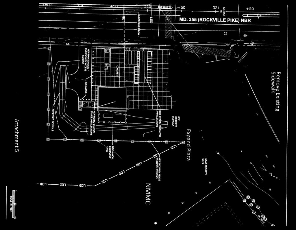
1 MONTGOMERY COUNTY PLANNING DEPARTMENT THE MARYLAND-NATIONAL CAPITAL PARK AND PLANNING COMMISSION MCPB Item No. 9 Date: MD355 Crossing (BRAC) Project, CIP Project , Mandatory Referral No. MR Larry Cole, Master Planner, larry.cole@montgomeryplanning.org, Marco Fuster, Senior Planner, marco.fuster@montgomeryplanning.org, John Marcolin, Planner Coordinator, john.marcolin@montgomeryplanning.org, Mary Dolan, Chief, mary.dolan@montgomeryplanning.org, Completed: 12/19/13 Description This Montgomery County Department of Transportation (MCDOT) project includes construction of a deep tunnel connection to the Medical Center Metro Station with access provided via three elevators on the east side of MD355, and of a pedestrian and bike underpass of MD355 with access provided to and from both sides of the road via stairs, escalators, and elevators. The project is located within the Bethesda-Chevy Chase Master Plan area. See Project Vicinity Map below. Summary This project is the final project to be submitted for Mandatory Referral review that is associated with the Base Relocation and Closure (BRAC) move of the Walter Reed Army Medical Center from Washington, DC to the former National Naval Medical Center in Bethesda, now renamed the National Military 1
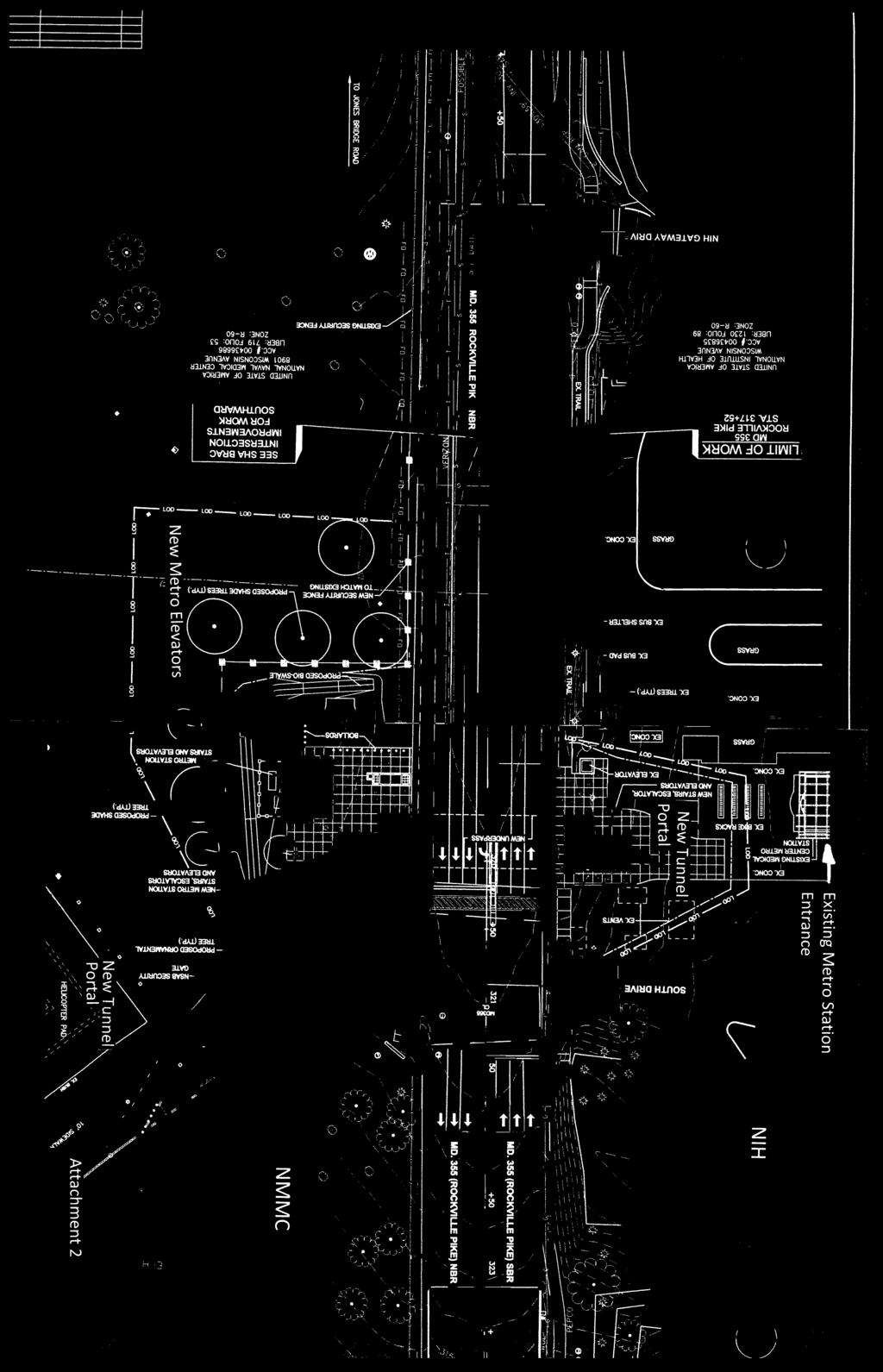
2 Medical Center (NMMC). The project would provide a grade-separated pedestrian and bicyclist crossing at the very busy intersection of MD355/South Drive/South Wood Road and would provide direct access to the Medical Center Metro Station from the east side of MD355 in front of NMMC. While the project is intended to improve accommodation for bicyclists and pedestrians, including transit users, conditions for drivers would also improve because of the fewer potential conflicts that are currently the source of travel delays. We recommend that the Board approve this project with the following comments to MCDOT. Recommended Board Comments 1. Expand the plaza area on the west side of MD355 to the north to eliminate the need for users of the crosswalk on the south leg of the intersection to make two right turns to access the Metro station or enter the National Institutes of Health (NIH). 2. Increase the width of the bike path adjacent to the tunnel portal on the west side of MD355 to twelve feet if possible to provide a shy distance from the portal wall. 3. Expand the plaza area on the east side to the north to facilitate a smooth movement for users of the crosswalk on the south leg of the intersection headed toward NMMC. 4. Remove the existing short and narrow sidewalk segment that runs along South Wood Road to improve pedestrian movement in this area and to allow a better landscaped buffer between the plaza and the road. 5. Provide lighting of the tunnel, portals, elevators areas, and the MD355/South Drive/South Wood Road intersection that meets the standards of the American Association of State Highway and Transportation Officials (AASHTO). 6. Provide adequate directional signage to avoid confusion for first time visitors 7. Submit a new Forest Conservation Exemption application if there is any significant change to the limit of disturbance (LOD) shown in the approved exemption plan E. Previous Board action On December 6, 2010, staff briefed the Planning Board on this project. The Board s follow-up letter to MCDOT is shown as Attachment 1. The design reflected in the Mandatory Referral is consistent with the Board s recommendations. The subject project abuts the Rockville Pike (MD355)/Center Drive/Jones Bridge Road BRAC intersection project, which was reviewed by the Board as a Mandatory Referral and approved with comments on July 22, Site context This project is located at the signalized intersection of Rockville Pike (MD 355) and South Drive/ South Wood Road. NIH is located on the west side of MD 355/Rockville Pike and the NMMC is located on the 2
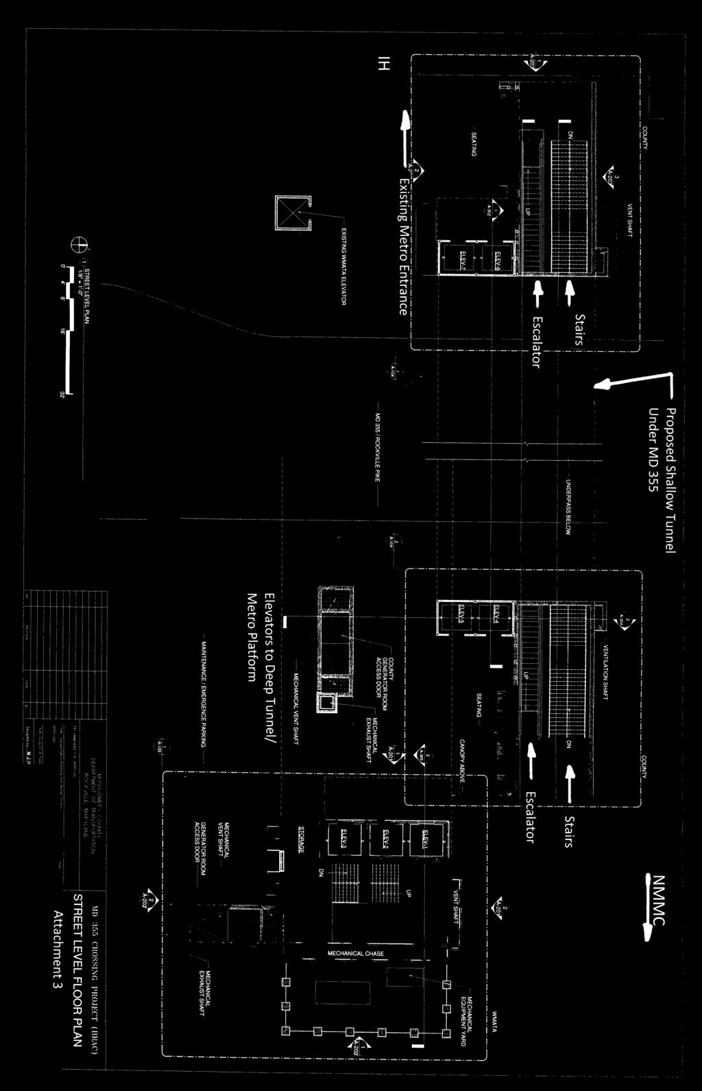
3 east side of Rockville Pike/ MD 355. The Medical Center Metrorail Station access point, a kiss-and-ride lot, and a bus station with six bus bays are all located on the NIH side of the intersection. The bus station serves Metrobus, RideOn and NIH and NMMC shuttle buses. Pedestrians traveling to NMMC cross the intersection at grade. Project Description This project would construct a shallow pedestrian tunnel beneath Rockville Pike and deep elevators on the east side of Rockville Pike connecting the Medical Center Metrorail Station mezzanine to street level, complementing the existing Metro elevators on the west side of Rockville Pike (see Attachment 2 for the overall plan with landscaping, and Attachment 3 for the street level floor plan showing the arrangement of stairs escalators, and elevators). Metrorail users would benefit from direct access between the Metrorail station mezzanine and South Wood Road without crossing Rockville Pike at grade. Bus patrons, pedestrians, and bicyclists would benefit by having the ability to travel between the NIH and NMMC without crossing Rockville Pike at grade. Drivers would benefit by the relocation of some pedestrian and bicyclist movements from the surface to below the grade of the road. The project would: Enhance/improve access to mass transit facilities Improve the mobility and safety of pedestrians and bicyclists crossing MD 355/Rockville Pike Improve traffic operations at the existing intersection of South Wood Road/South Drive/MD 355 Safety for transit patrons would also be improved by means of the proposed emergency stairs adjacent to the Metro elevators on the east side of MD355 that would facilitate the evacuation of the Metro station in the event of an emergency. Master Plan Consistency The 1990 Bethesda-Chevy Chase Master Plan does not provide specific recommendations for improving the MD355/ South Drive/South Wood Road intersection or a new Metrorail station entrance. However, the Master Plan emphasizes the importance of transit, rather than roadways, to meet the needs of the Plan area. The Plan recommends that additional transportation service in Bethesda-Chevy Chase should be based primarily on an expanded and vigorous program of transit and other mobility services. Use of these services is necessary because of the difficulty of expanding the capacity of many B-CC highways and due to the need to accommodate increased through traffic and the recommended level of development in B-CC. (p.97) The proposed new Medical Center Metrorail Station entrance on the Navy property supports the Plan s recommendations. The Master Plan notes that the NMMC property s critical location necessitated the development and implementation of such alleviation measures as the use of carpools, vanpools, employee-owned buses, and public transportation (p.93). It further notes that any future expansion of jobs or parking at Federal facilities be considered only in conjunction with an effective ridesharing/transit incentive program (p.92). The new Metrorail station entrance with elevators will further improve non-auto access to the NMMC campus. 3
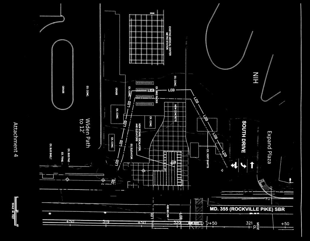
4 Additional analysis Transit Accommodation in the Roadway The Countywide Transit Corridors Functional Master Plan (CTCFMP) includes MD355 South as one of the recommended transit corridors. In the subject project area, a recommendation is made for dedicated transit lanes. A specific type of treatment is not recommended, but because of the CTCFMP s high forecast ridership, a two-lane median busway or dedicated curb lanes are likely potential treatments. Based on MCDOT s preliminary evaluation, a BRT station and transit lanes is not precluded by this project. The proposed BRT typical section can be accommodated within the proposed roadway section of the MD 355 Crossing (BRAC), which is the same as the existing condition. Pedestrian and Bicyclist Accommodation The shallow tunnel would provide a grade-separated crossing for pedestrians and bicyclists, who would access the tunnel on each side via stairs, escalators in the UP direction, and two elevators. The at-gradeintersection would remain open however and would be made fully compliant with the American with Disabilities Act (ADA)-. On the west side of MD355, improvements should be made to facilitate pedestrian and bicyclist movement (see Attachment 4): The plaza area should be expanded in the area of the handicap ramp to eliminate the need for users of the crosswalk on the south leg of the intersection to make two right turns to access the Metro station or enter NIH. The bike path width on the east side of the tunnel portal should be increased to ten feet. On the east side of MD355, the following improvements should be made (see Attachment 5): The plaza area should be expanded on the north side to facilitate a smooth movement for users of the crosswalk on the south leg of the intersection headed toward NMMC. The existing short and narrow sidewalk segment that runs along South Wood Road should be deleted for clarity of movement in this area and to allow a better landscaped buffer between the plaza and the road A bikeshare station will be provided at this Metro station. MCDOT is currently discussing with WMATA and NIH a location in the existing Metro parking lot, outside the immediate area of the subject project. The lighting plans that have been prepared for this project are intended to ensure adequate lighting of the tunnel portals and elevators but do not address any deficiencies at the MD355/South Drive/South Wood Road intersection where some pedestrians and bicyclists will still be crossing at grade and where they will be most exposed to potential traffic hazards. We recommend that that lighting at this intersection be provided at AASHTO-recommended levels recommended to ensure that pedestrian and bicyclist safety is comprehensively addressed. Environmental Review, Forest Conservation and Tree Save No forests, streams or other environmentally sensitive features exist on the subject property area. Some areas of steep slopes are located nearby along Route 355, however the slopes are man-made areas that 4
5 were graded for the construction of 355 and are maintained with a cover of manicured lawn. A number of individual trees and hedgerows occur along Route 355 within the project area. A grove of existing trees is located at the of east side of the proposed crossing. The grove contains a variety of tree types and sizes, including a notable 46 Red Oak. The site is located within the Rock Creek Watershed, which is a Use I watershed*. A forest conservation exemption # E was confirmed for the MD355 Crossing on July 29, The project qualifies for the exemption under 22A-5(t) as a modification to an existing developed property. The project meets the criteria of the exemption by: (1) not removing more than 5,000 square feet of forest (no forest removal is proposed), (2) not affecting any forest in a stream valley buffer or forest located on a property in a special protection area (no stream valleys or special protection areas are in the project vicinity), and (3) the modification does not require the approval of a new subdivision plan. The proposed project has a limited number of tree removals including the 46 red Oak and other specimen trees. Since the work qualifies for an exemption and is not subject to forest conservation plan, no variance for removal or impacts of trees is required**. The project is not subject to a tree save plan, however the plans are only conceptual at this stage and the final designs potentially may include LOD beyond the areas shown on the 355 crossing exemption plan ( E). Due to the design-build nature of the project which has not been awarded yet, the ultimate design and associated LOD will not be known for some time. Therefore a new exemption may be required to reflect the ultimately proposed LOD if there are substantial changes from the LOD as shown on the existing exemption plans. *Use I: WATER CONTACT RECREATION & PROTECTION OF AQUATIC LIFE Waters that are suitable for: water contact sports: play and leisure time activities where the human body may come in direct contact with the surface water; fishing; the growth and propagation of fish (other than trout); other aquatic life, and wildlife; agricultural water supply and industrial water supply. ** Removal or impacts to trees that measure 30 inches DBH or greater; are part of a historic site or designated with a historic structure; are designated as national, state, or county champion trees; are at least 75 percent of the diameter of the current State champion tree of that species; or trees, shrubs, or plants that are designated as Federal or State rare, threatened, or endangered species, are subject to a variance under applications that are subject to a forest conservation plan. Landscaping/Streetscaping Shade and ornamental are proposed around the immediate area of the plaza on the east side of MD355 to screen the area from the NMMC campus. The plaza on the west side would be an expansion of the already existing Metro station plaza. Seating would be provided at each tunnel portal. 5
6 The proposed design of the tunnel portals, canopies and elevator enclosures is attractive and is currently under review by the National Capitol Planning Commission; renderings of these structures will be shown at the Board s meeting. One comment has been made by the Maryland Historical Trust (MHT) in regard to an east side elevator enclosure (see below). Signage that identifies the underpass and helps distinguish it from the deep metro elevators on the east side is not shown, except for the large Metro logo on the proposed elevators. We recommend that adequate directional signage be provided to avoid confusion for first time visitors. Historic Preservation In the area of the project, there are two historic properties listed on the Master Plan for Historic Preservation: #35-8, the Bethesda Naval Hospital on the east side of MD355, and #35-9, the Peter Estate on the west side of MD355. The subject project would not impact the historic setting of either property, including the protected viewshed of the hospital. However, MHT has commented that the height of the elevator enclosure at the shallow tunnel portal on the east side of MD355 should be reduced. Park Impacts No parks exist within the project limits. Outreach A public notice of this Planning Board meeting was sent by staff to area community associations. Prior to the Mandatory Referral submission of this project, MCDOT held several public meetings and workshops. Conclusion The proposed project should be approved with the recommended Board comments. 6
7
8
9
10
11
MONTGOMERY COUNTY PLANNING DEPARTMENT THE MARYLAND-NATIONAL CAPITAL PARK AND PLANNING COMMISSION
 MONTGOMERY COUNTY PLANNING DEPARTMENT THE MARYLAND-NATIONAL CAPITAL PARK AND PLANNING COMMISSION SHA CTP Project No. MO891A21, US 29, Fairland Road to Musgrove Road Interchange Improvement, Design Review
MONTGOMERY COUNTY PLANNING DEPARTMENT THE MARYLAND-NATIONAL CAPITAL PARK AND PLANNING COMMISSION
 MONTGOMERY COUNTY PLANNING DEPARTMENT THE MARYLAND-NATIONAL CAPITAL PARK AND PLANNING COMMISSION MCPB Item No. 4 Date: 04-17-14 2014 Mobility Assessment Report José Dory, Senior Planner, Functional Planning
Fitting Light Rail through Well-established Communities
 Fitting Light Rail through Well-established Communities San Francisco 2008 Michael D. Madden Chief, Project Development, Maryland Transit Administration Project Setting Located inside the Capital Beltway
Proposed White Flint Separated Bike Lane Network September 2015
 Proposed White Flint Separated Bike Lane Network September 2015 Abstract This report includes a proposed separated bike lane network for the White Flint Sector Plan area. Separated bike lanes create a
Comments EXECUTIVE SUMMARY
 Comments 1. Under any Alternatives, MCDOT should provide better at-grade pedestrian crossing of Georgia Avenue and Forest Glen Road, including improved crosswalks with wider medians and adequate signal
MCPB Item No. 5 Date: White Flint West Transportation, Phase 2, CIP No , Mandatory Referral No. MR
 MONTGOMERY COUNTY PLANNING DEPARTMENT THE MARYLAND-NATIONAL CAPITAL PARK AND PLANNING COMMISSION MCPB Item No. 5 Date: 09-10-15 White Flint West Transportation, Phase 2, CIP No. 501116, Mandatory Referral
Countywide Transit Corridors Functional Master Plan
 Countywide Transit Corridors Functional Master Plan Makeover Montgomery II May 10, 2014 Master Plan Status Begun: August 2011 Planning Board Approved Draft Plan: July 2013 Council Approved Final Plan:
APPENDIX A: Complete Streets Checklist DRAFT NOVEMBER 2016
 APPENDIX A: Complete Streets Checklist DRAFT NOVEMBER 2016 Complete Streets Checklist MetroPlan Orlando s Complete Streets Checklist is an internal planning tool for staff to further implementation of
Prince George s County plans, policies, and projects
 Prince George s County plans, policies, and projects Over 250 projects for trails, bikeways, designated bike lanes and sidewalk construction Trail projects that improve access to Metro Sidewalk and trail
MONTGOMERY COUNTY PLANNING DEPARTMENT THE MARYLAND-NATIONAL CAPITAL PARK AND PLANNING COMMISSION
 MONTGOMERY COUNTY PLANNING DEPARTMENT THE MARYLAND-NATIONAL CAPITAL PARK AND PLANNING COMMISSION MCPB Item No. 3 Date: 01-19-12 Worksession: Countywide Transit Corridors Functional Master Plan Larry Cole,
Presentation of Staff Draft March 18, 2013 COUNTYWIDE TRANSIT CORRIDORS FUNCTIONAL MASTER PLAN
 Presentation of Staff Draft March 18, 2013 COUNTYWIDE TRANSIT CORRIDORS FUNCTIONAL MASTER PLAN Public Outreach Fall 2011: Two community meetings/open houses Fall 2012: Three community meetings/open houses
MONTGOMERY COUNTY PLANNING DEPARTMENT THE MARYLAND-NATIONAL CAPITAL PARK AND PLANNING COMMISSION
 MONTGOMERY COUNTY PLANNING DEPARTMENT THE MARYLAND-NATIONAL CAPITAL PARK AND PLANNING COMMISSION MCPB Item No. 5 Date: 12/3/15 Draft White Flint Separated Bike Lanes Network David Anspacher, Functional
01. VICINITY OF GREENBRAE POC: EXISTING CONDITIONS
 01. VICINITY OF GREENBRAE POC: EXISTING CONDITIONS Existing Bus Stop Existing US101 On-ramp Existing POC Old Redwood Highway Rich Street City ROW Environmental Study Limit Industrial Way NO DESIGNATED
MONTGOMERY COUNTY COUNCIL
 MONTGOMERY COUNTY COUNCIL R O C K V I L L E, M A R Y L A N D October 20, 2015 The Honorable Isiah Leggett Montgomery County Executive 101 Monroe Street, 2nd Floor Rockville, MD 20850 Dear County Executive
NJDOT Complete Streets Checklist
 Background The New Jersey Department of Transportation s Complete Streets Policy promotes a comprehensive, integrated, connected multi-modal network by providing connections to bicycling and walking trip
Bikeway Elements. Study Area A: Needwood Road and Vicinity (Figures 3 and 4)
") B R I G G S C H A N E Y R O A D I N T E R C H A N G E The ROD includes a partial interchange at Briggs Chaney Road, which is not included in the Fairland Master Plan. This interchange includes ramps to
B R I G G S C H A N E Y R O A D I N T E R C H A N G E The ROD includes a partial interchange at Briggs Chaney Road, which is not included in the Fairland Master Plan. This interchange includes ramps to
2014 Mobility Assessment Report Functional Planning & Policy Montgomery County Planning Department
 2014 Mobility Assessment Report Functional Planning & Policy Montgomery County Planning Department Travel Trends National & Local Travel Trends Multi-Modal Monitoring Pedestrian Bikes Bus Rail Future Efforts
section 4 Existing Conditions, Issues, and Options
 section 4 Existing Conditions, Issues, and Options 4.0 Existing Conditions, Issues, and Options This section analyzes each segment of the corridor on a street to street basis. Each segment is discussed
WASHINGTON METROPOLITAN AREA TRANSIT AUTHORITY. Final Report January 2006
 M metro WASHINGTON METROPOLITAN AREA TRANSIT AUTHORITY STADIUM-ARMORY ARMORY STATION AREA PLANNING STUDY Final Report January 2006 Washington Metropolitan Area Transit Authority Department of Planning
Ballston Station Multimodal Study WMATA and Arlington County. Meeting Minutes
 Date of Meeting: June 10, 2010 Location: Ballston Metrorail Station and NRECA Building 4301 Wilson Blvd, Arlington, VA Subject: Ballston Station Multimodal Study Stakeholder Meeting #1 Summary: This first
City of Davis East Covell Corridor Plan
 Community Open House #2 January 22, 2014 6:00 8:00 p.m. Veterans Memorial Center, Club Room City of Davis Introduction The (ECCP) is a taking a comprehensive look at the existing transportation systems
Agenda. Overview PRINCE GEORGE S PLAZA METRO AREA PEDESTRIAN PLAN
 PRINCE GEORGE S PLAZA METRO AREA PEDESTRIAN PLAN May 28, 2008 Agenda Welcome and introductions Project overview and issue identification Planning context and strengths Design challenges and initial recommendations
See Figure 38, Existing Nonmotorized Connections.
 Nonmotorized Connections Existing Nonmotorized Connections Pedestrian, vehicle and bike traffic access and movements are confined primarily to Penny Drive on campus. Due to the steep slope along the length
C C C
 C-012-001 Thank you for your support for the creation of new public space and nonmotorized access between downtown and the waterfront through the Overlook Walk, the East-West Connections, and the Promenade.
Eliminate on-street parking where it will allow for a dedicated bus only lane %
 Traffic Dashboard Priorities Survey Responses Introduction 1) Are you familiar with bus rapid transit (BRT)? a. No, BRT is new to me. 597 23.5% b. I ve heard of BRT, but I don t know much about it. 1,136
Pedestrian, Bicycle and Traffic Calming Strategic Implementation Plan. January 18, 2011
 Pedestrian, Bicycle and Traffic Calming Strategic Implementation Plan January 18, 2011 Tonight s Agenda Receive update on project Provide feedback on two policy issues Complete Streets Policy Project Prioritization
Off-road Trails. Guidance
 Off-road Trails Off-road trails are shared use paths located on an independent alignment that provide two-way travel for people walking, bicycling, and other non-motorized users. Trails specifically along
Preliminary Transportation Analysis
 Preliminary Transportation Analysis Goals of a Robust, Multimodal Transportation Network Safe Accessible/Connected Efficient Comfortable Context-Sensitive Motor Vehicle: Continue to analyze the data to
MONTGOMERY COUNTY PLANNING DEPARTMENT
 MONTGOMERY COUNTY PLANNING DEPARTMENT THE MARYLAND-NATIONAL CAPITAL PARK AND PLANNING COMMISSION Tilden Middle School/Rock Terrace School, Mandatory Referral, MR2017014 MCPB Item No. Date: 11-09-17 Amy
Alaskan Way, Promenade, and Overlook Walk Final EIS
 I-065-001 As described in Section 3.7.2 of the Draft EIS, the loss of on-street and off-street parking may require drivers to park off-street or travel farther to find available on-street or off-street
Item to be Addressed Checklist Consideration YES NO N/A Required Description Complete Streets Guidelines
 Passaic County Complete Streets Checklist - Concept Development Project Name Item to be Addressed Checklist Consideration YES NO N/A Required Description Complete Streets Guidelines Existing Plans Have
Existing Transportation System
 < Open for Additional Text Transportation System Existing Transportation System This section describes vehicular transportation associated with Children s. transportation are described in a separate section
10.0 CURB EXTENSIONS GUIDELINE
 10.0 CURB EXTENSIONS GUIDELINE Road Engineering Design Guidelines Version 1.0 March 2017 City of Toronto, Transportation Services City of Toronto Page 0 Background In early 2014, Transportation Services
10A. DATE: October 5, Pedestrian and Bicycle Advisory Committee. Kevin Colin, Deputy Planning Manager Curt Bates, City Engineer
 10A DATE: October 5, 2016 TO: PREPARED BY: SUBJECT: Pedestrian and Bicycle Advisory Committee Kevin Colin, Deputy Planning Manager Curt Bates, City Engineer Discussion and Provide Comments, Associated
Vision: Traditional hamlet with an attractive business/pedestrian friendly main street connected to adjacent walkable neighborhoods
 N D. Focus Area II Vision: Traditional hamlet with an attractive business/pedestrian friendly main street connected to adjacent walkable neighborhoods Transit Road Focus Area II is located in the Hamlet
Giles Run Connector Road
 Giles Run Connector Road Laurel Hill Adaptive Reuse Area to Laurel Crest Drive South County Federation Meeting June 14, 2016 History Connector road included in the Laurel Hill Comprehensive Plan amendment
Poor pavement condition Substandard Intersections. / Substandard bike/pedestrian/transit accommodations. Driveway access Environmental concerns
 Public Informational Meeting University Avenue (Allen Boulevard Segoe Road) March 23, 2011 City of Madison City of Middleton Village of Shorewood Hills Dane County Existing Roadway Conditions Poor pavement
PRINCE GEORGE S PLAZA METRO AREA PEDESTRIAN PLAN
 PRINCE GEORGE S PLAZA METRO AREA PEDESTRIAN PLAN May 28, 2008 Agenda Welcome and introductions Project overview and issue identification Planning context and strengths Design challenges and initial recommendations
Lee s Summit Road Improvement Study Public Open House June 7, 2007 Summary of Comment Card Responses
 Lee s Summit Road Improvement Study Public Open House June 7, 2007 Summary of Comment Card Responses Introduction At the Lee s Summit Road Improvement Study Public Open House held Thursday, June 7, 2007
Chapter 2: Standards for Access, Non-Motorized, and Transit
 Standards for Access, Non-Motorized, and Transit Chapter 2: Standards for Access, Non-Motorized, and Transit The Washtenaw County Access Management Plan was developed based on the analysis of existing
5. RUNNINGWAY GUIDELINES
 5. RUNNINGWAY GUIDELINES These guidelines should be considered collectively when making runningway decisions. A runningway is the linear component of the transit system that forms the right-of-way reserved
3.9 Recreational Trails and Natural Areas
 3.9 Recreational Trails and Natural Areas 3.9.1 Introduction Parks and other recreational facilities such as trails, bicycle routes, and open space are important community resources. This section discusses
City of Sammamish. Welcome. Issaquah-Fall City Road Improvements Project Phase I Design: 242nd Avenue SE to Klahanie Drive SE
 Welcome Welcome to the third community meeting for the Issaquah-Fall City Road Improvements Project. AGENDA 6:00 p.m. Welcome and sign-in 6:10 p.m. Presentation 6:50 p.m. Open house Learn about the roadway
MONTGOMERY COUNTY PLANNING DEPARTMENT THE MARYLAND-NATIONAL CAPITAL PARK AND PLANNING COMMISSION
 MONTGOMERY COUNTY PLANNING DEPARTMENT THE MARYLAND-NATIONAL CAPITAL PARK AND PLANNING COMMISSION MCPB Item No. 4 Date: 09-10-15 Scope of Work for the Bicycle Master Plan David Anspacher, Planner/Coordinator,
PenPlace SPRC #6. September 27, DRAFT
 PenPlace SPRC #6 1 Agenda Site and Project Overview Multiple Transportation Options Traffic Analysis Neighborhood Analysis Street Network Street Sections/Sidewalk Width Pedestrian/Bicycle Circulation Secure
Lincoln Way Multimodal Safety and Operations Study. City and University Summary Presentation
 Lincoln Way Multimodal Safety and Operations Study City and University Summary Presentation February 27, 2018 Agenda Introductions Study Overview: Phase 1 - Discovery Phase 2 Improvement Recommendations
HARRISON STREET/OAKLAND AVENUE COMMUNITY TRANSPORTATION PLAN
 HARRISON STREET/OAKLAND AVENUE Community Workshop #4: Draft Plan Review December 3, 2009 D E S I G N, C O M M U N I T Y & E N V I R O N M E N T INTRODUCTIONS Key Project Staff: Alisa Shen, Project Manager,
5/7/2013 VIA . RE: University Village Safeway Expansion (P13-019)
") 5/7/2013 VIA EMAIL David Hung, Associate Planner Community Development Department, Current Planning Division City of Sacramento 300 Richards Boulevard, 3 rd Floor Sacramento, CA 95811 RE: University Village
5/7/2013 VIA EMAIL David Hung, Associate Planner Community Development Department, Current Planning Division City of Sacramento 300 Richards Boulevard, 3 rd Floor Sacramento, CA 95811 RE: University Village
Development of Arlington County s Marked Crosswalk Guidelines. Jon Lawler, P.E. Design Engineer Arlington County, VA
 Development of Arlington County s Marked Crosswalk Guidelines Jon Lawler, P.E. Design Engineer Arlington County, VA April 13, 2015 Transportation System Users Residents Estimated 215,000 in 2014 Lowest
City of Madison, East Johnson Street North Baldwin Street to First Street Local Street Dane County
 City of Madison, East Johnson Street North Baldwin Street to First Street Local Street Dane County Public Involvement Meeting Thursday, November 10, 2016 5:30 to 7 P.M. Festival Foods 810 E. Washington
Montgomery County Life Sciences Center Loop Trail
 Montgomery County Life Sciences Center Loop Trail Advisory Committee Meeting #1 February 10, 2015 Agenda 1. Project Background 2. Existing Conditions Analysis 3. Examples from Elsewhere 4. Discussion Project
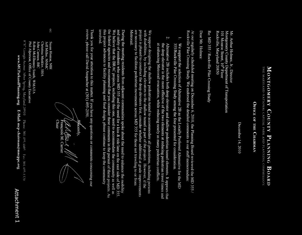
bcc: Al Roshdieh, Deputy Director, MCDOT cc: Edgar Gonzalez, Deputy Director, MCDOT cc: Gary Erenrich, Special Assistant to the Director, MCDOT cc:
 bcc: Al Roshdieh, Deputy Director, MCDOT cc: Edgar Gonzalez, Deputy Director, MCDOT cc: Gary Erenrich, Special Assistant to the Director, MCDOT cc: Bruce Johnston, Chief, DTE, MCDOT cc: Emil Wolanin, Chief,
Executive Summary Route 30 Corridor Master Plan
 Route Corridor Master Plan Project Overview The Route Corridor Master Plan is a coordinated multimodal transportation and land use plan for the entire stretch of Route through East Whiteland Township,
Washington Metropolitan Area Transit Authority Board Action/Information Summary
 Washington Metropolitan Area Transit Authority Board Action/Information Summary Action Information MEAD Number: 200242 Resolution: Yes No TITLE: MWCOG Strategic Investment Plan & TPB Priorities PRESENTATION
Blair/Williamson Intersection Expressed Needs
 Blair/Williamson Intersection Expressed Needs NORTH Blair Street is a barrier for pedestrians and bicycles Relocate Capitol City Trail crossing from Blair Street and John Nolen Drive intersection to Williamson
Active Transportation Rail to River Corridor. Community Meeting - Segment A
 Active Transportation Rail to River Corridor Community Meeting - Segment A June 29, 2017 Tonight s Agenda > Open House (30 min) > Welcome / Project Overview > Presentation of 30% Design Refinements > Next
Clay Street Bridge Replacement Project
 Clay Street Bridge Replacement Project Frequently Asked Questions (FAQs) The project is located in downtown Placerville on Clay Street between US Highway 50 and Main Street and Cedar Ravine Road. The proposed
Roadways. Roadways III.
 Introduction 97 Roadway Design Principles 98 Safe Speeds 99 Optimizing of Street Space 00 Minimum Lane Widths in the City of Boston 02 Design Features that Reduce Operating Speeds 05 Travel Lanes Transit
Ocean Park Boulevard Green Street Project Alternatives & Trade Offs
 Planning Commission March 4, 2009 Ocean Park Boulevard Green Street Project Alternatives & Trade Offs Purpose of Tonight s Meeting Review concept plans and options Provide input on alternatives and trade-offs
MAG Town of Cave Creek Bike Study Task 6 Executive Summary and Regional Significance Report
 Page 1 MAG Town of Cave Creek Bike Study Task 6 Executive Summary and Regional Significance Report August 1, 2012 MAG Project #481 Page 2 Task 6 Executive Summary and Regional Significance Report Introduction
MONTGOMERY COUNTY PLANNING DEPARTMENT
 MONTGOMERY COUNTY PLANNING DEPARTMENT THE MARYLAND-NATIONAL CAPITAL PARK AND PLANNING COMMISSION MCPB Item No Date: 6-07-2018 MD355 Over Little Bennett Creek Bridge Replacement (SHA Project No. MO4275180),
Providence Downtown Transit Connector STAKEHOLDER MEETING #2. Stakeholder Meeting #1 October 24, 2016
 Providence Downtown Transit Connector STAKEHOLDER MEETING #2 Stakeholder Meeting #1 October 24, 2016 February 2017 1 AGENDA 1 DTC Goals and Expectations 2 Street Design Concepts 3 Potential Benefits and
City of Gainesville Transportation/Roadway Needs PROJECT SUMMARY
 A1 Roadway Resurfacing $23,846,000 TYPE: Preservation of existing system Roadway resurfacing A2 Signal Replacement $6,000,000 TYPE: Preservation of existing system Replace traffic signals. B1 W 6th St
Central Jersey Transportation Forum. March 2007
 Central Jersey Transportation Forum March 2007 Feasibility Analysis of BRT on Dinky Right of Way from Princeton Station to Alexander Rd. in West Windsor (west of Rt. 1) Study spurred by Princeton University's
Anne Arundel County BICYCLE, PEDESTRIAN, TRANSIT ASSESSMENT GUIDELINES
 Anne Arundel County BICYCLE, PEDESTRIAN, TRANSIT ASSESSMENT GUIDELINES December 2018 TABLE OF CONTENTS I. Executive Summary 3 II. When Is A Bicycle Pedestrian Transit Assessment (BPTA) Required? 4 III.
9/25/2018. Multi-Modal Level of Service (MMLOS) Bianca Popescu, Transportation Planner
 Bianca Popescu, Transportation Planner") Multi-Modal Level of Service (MMLOS) Bianca Popescu, Transportation Planner 1 What is MMLOS? Is this a nice place to walk? Is this a nice place to bike? Is transit convenient? Bottom line - Are there options
Multi-Modal Level of Service (MMLOS) Bianca Popescu, Transportation Planner 1 What is MMLOS? Is this a nice place to walk? Is this a nice place to bike? Is transit convenient? Bottom line - Are there options
Mission-Geneva Transportation Study Community Workshop 2 July 8, 2006
 Community Workshop 2 July 8, 2006 Small Group Workbook 1 Basic Improvements on Mission Street Streetscape. Pedestrian-scale lighting; landscaping; community art on utility boxes; more (possibly unique)
SECTION 1 - TRAFFIC PLANNING
 SECTION 1 - TRAFFIC PLANNING 1.1 TRAFFIC OPERATIONS 1.1.1 Roadway Functional Classification The Multnomah County Comprehensive Framework Plan s Policy 34: Trafficways and the Functional Classification
FONTAINE AVENUE STUDY Final Report
 FONTAINE AVENUE STUDY Final Report March 28, 2005 FONTAINE AVENUE STUDY City of Charlottesville March 28, 2005 Renaissance Planning Group Kenneth Schwartz, FAIA, AICP Director of Design Leigh Wilkerson,
5 CIRCULATION AND STREET DESIGN
 5 CIRCULATION AND STREET DESIGN This chapter describes circulation and streetscape improvements proposed for the Northwest Chico Specific Plan Area. It includes detailed design specifications for existing
S T A T I O N A R E A P L A N
 The Circulation and Access Plan describes vehicle, pedestrian, and transit improvements recommended within the Concept Plan. In order to create and sustain a vibrant business district that provides pedestrian-friendly
ROUTE 81 CORRIDOR STUDY DESIGN CONCEPTS
 RT 81 Corridor Study CLINTON ROUTE 81 CORRIDOR STUDY DESIGN CONCEPTS View north on High Street, with potential improvements to the streetscape Draft Recommendations November 8 th, 2018 TOWN OF CLINTON
Multimodal Through Corridors and Placemaking Corridors
 68 Multimodal Through Corridors and Placemaking Corridors Corridors have different functions in a region. Some corridors are used to get smoothly and rapidly through a region or to get quickly to major
VIRGINIA RAILWAY EXPRESS
 PREPARING FOR THE NEXT QUARTER-CENTURY Arlington County Board Work Session June 28, 2017 1 TODAY S PRESENTATION VRE Overview VRE in Arlington County VRE System 2040 Plan Future Vision for Crystal City
MARTIN LUTHER KING JR. WAY
 OCTOBER 2011 40 Vision and Goals The Martin Luther King, Jr. Way Illustrative Master Plan that follows has been developed through a process of community involvement. It expresses a long term vision for
Ownership Lots 17 & 18 (Part of Lot 14), Montgomery Auto Sales Park
, Montgomery Auto Sales Park") Traffic Impact Analysis Ownership Lots 17 & 18 (Part of Lot 14), Montgomery Auto Sales Park Silver Spring, MD Lot 17: Site Plan No. 821413 Lot 18: Site Plan No. 821414 Filing Number: 13-TS-1198527A Prepared
Traffic Impact Analysis Ownership Lots 17 & 18 (Part of Lot 14), Montgomery Auto Sales Park Silver Spring, MD Lot 17: Site Plan No. 821413 Lot 18: Site Plan No. 821414 Filing Number: 13-TS-1198527A Prepared
Transportation. Pages E-3 to E-145 PROPOSED FY CAPITAL IMPROVEMENT PLAN (CIP) CCCRC Presentation Thursday, June 14, 2018
 CCCRC Presentation Thursday, June 14, 2018") PROPOSED FY 2019-2028 CAPITAL IMPROVEMENT PLAN (CIP) Pages E-3 to E-145 CCCRC Presentation Thursday, June 14, 2018 in the CIP Continues Arlington s commitment to a transportation system that expands travel
PROPOSED FY 2019-2028 CAPITAL IMPROVEMENT PLAN (CIP) Pages E-3 to E-145 CCCRC Presentation Thursday, June 14, 2018 in the CIP Continues Arlington s commitment to a transportation system that expands travel
Arlington County 10-Year Transit Development Plan & Premium Transit Network Briefing. May 2016
 Arlington County 10-Year Transit Development Plan & Premium Transit Network Briefing May 2016 Overview 10-Year Transit Development Plan Premium Transit Network Columbia Pike service concept Premium amenities
Issue Commentary Staff Response
 MONTGOMERY COUNTY PLANNING DEPARTMENT THE MARYLAND-NATIONAL CAPITAL PARK AND PLANNING COMMISSION MCPB Item No. 9 Date: 11-1-18 Local Area Transportation Review (LATR) Pedestrian Adequacy Test Technical
Transportation 6. A. Transit Center Circulation and Access. 1. Transit Center Circulation
 Transportation 6 This chapter describes the transportation system in and around the Hillsdale Station Area, with a focus on the Transit Center at the relocated Hillsdale Caltrain Station. The transportation
Community Task Force November 15, 2017
 Community Task Force November 15, 2017 Welcome and Introductions Project Partners Regional Transportation District (RTD) Colorado Department of Transportation (CDOT) Denver Regional Council of Governments
Columbia Pike Implementation Team (CPIT) Meeting
 Meeting") Columbia Pike Implementation Team (CPIT) Meeting November 30, 2010 Agenda Introductions / Purpose of Meeting Review of project goals Multimodal project: 10% street design between the curbs Discussion Multimodal
Columbia Pike Implementation Team (CPIT) Meeting November 30, 2010 Agenda Introductions / Purpose of Meeting Review of project goals Multimodal project: 10% street design between the curbs Discussion Multimodal
MONTGOMERY COUNTY PLANNING DEPARTMENT
 MONTGOMERY COUNTY PLANNING DEPARTMENT THE MARYLAND-NATIONAL CAPITAL PARK AND PLANNING COMMISSION Veirs Mill Corridor Master Plan: Work Session #5 MCPB Item No. Date: 10/04/18 Jessica McVary, Planner Coordinator,
ADA TRANSITION PLAN 2013
 ADA TRANSITION PLAN 2013 TABLE OF CONTENTS Contents Introduction 1 Purpose 2 Identified Obstacles to the Public Right of Way 3 Criteria for Determining Impediments at Village Facilities 4 Removing Barriers
 COMPLETE STREETS CHECKLIST City of Philadelphia The City of Philadelphia's Complete Streets policies are designed ensure that city streets are safe, comfortable and convenient for people of all ages and
Project Description Form 8AA
 Project Description Form 8AA Basic Project Information Submitting Jurisdiction/Agency: Fairfax County Project Title: Route 1 Widening: Mount Vernon Memorial Highway to Napper Road Project Location: US
City of Madison, East Johnson Street North Baldwin Street to First Street Local Street Dane County
 City of Madison, East Johnson Street North Baldwin Street to First Street Local Street Dane County Public Involvement Meeting Thursday, April 28, 2016 6 to 8 P.M. Lapham Elementary School 1045 E. Dayton
Chapter 3.9 Timbercrest Elementary School. Volusia County MPO. November 2008
 Chapter 3.9 Timbercrest Elementary School Deltona, FL Volusia County MPO November 2008 Volusia County MPO School Bicycle and Pedestrian Review Study, Phase 3B School Summary Timbercrest Elementary School
Table #6 VISION CHARACTERISTICS
 Table #6 VISION White Flint is a place to live, work, play, shop, and walk with sufficient density to encourage quality redevelopment. Vibrant streets and consistent streetscapes are important. CHARACTERISTICS
10/30/2012 VIA
 10/30/2012 VIA EMAIL David Hung, Associate Planner Community Development Department, Current Planning Division City of Sacramento 300 Richards Blvd., 3 rd Floor Sacramento, CA 95811 RE: The Cannery On-Site
APPENDIX G: INTERSECTION NEEDS AT OKEECHOBEE BOULEVARD
 APPENDIX G: INTERSECTION NEEDS AT OKEECHOBEE BOULEVARD INTERSECTION NEEDS AT SR 7 and OKEECHOBEE BOULEVARD SR 7 Extension Project Development and Environment (PD&E) Study From Okeechobee Boulevard (SR
Develop a Multi-Modal Transportation Strategy (Theme 6)
") DEVELOP A MULTI-MODAL TRANSPORTATION STRATEGY (THEME 6) WHY IS THIS THEME ADDRESSED? Develop a Multi-Modal Transportation Strategy (Theme 6) Statement of Ideal Reduce resident and visitor reliance on single
DEVELOP A MULTI-MODAL TRANSPORTATION STRATEGY (THEME 6) WHY IS THIS THEME ADDRESSED? Develop a Multi-Modal Transportation Strategy (Theme 6) Statement of Ideal Reduce resident and visitor reliance on single
Item No. 14 Town of Atherton
 Item No. 14 Town of Atherton CITY COUNCIL STAFF REPORT CONSENT AGENDA TO: THROUGH: FROM: HONORABLE MAYOR AND CITY COUNCIL GEORGE RODERICKS, CITY MANAGER MICHAEL KASHIWAGI, COMMUNITY SERVICES DIRECTOR MARTY
Chapter 3 BUS IMPROVEMENT CONCEPTS
 Chapter 3 BUS IMPROVEMENT CONCEPTS The purpose of this chapter is to describe potential bus improvement strategies and potential impacts or implications associated with BRT implementation within the existing
In station areas, new pedestrian links can increase network connectivity and provide direct access to stations.
 The Last Mile Planning for Pedestrians Planning around stations will put pedestrians first. Making walking to stations safe and easy is important; walking will be a part of every rapid transit Accessible
Design of Stanley Park S-Curve
 ADMINISTRATIVE REPORT Date: May 4, 2001 TO: FROM: Author/Local: F. Klotzbach/7118 RTS NO. 01644 CC File No. Standing Committee on Transportation and Traffic General Manager of Engineering Services, in
Southbend to Prima Vista. October 30, Floresta Corridor Master Plan
 Application of a Complete Street initiative and how it might function operationally 8 8 Southbend to Prima Vista October 30, 2017 Presentation Agenda 2 Perspective and History Traffic projections, Levels
Appendix T CCMP TRAIL TRAFFIC & TRANSPORTATION DESIGN STANDARD
 Appendix T CCMP 3.3.4 TRAIL TRAFFIC & TRANSPORTATION DESIGN STANDARD 3.3.4 Trail Traffic and Transportation Design Multi-use trails have certain design standards, which vary depending on the agency that
Welcome. If you have any questions or comments on the project, please contact:
 Welcome This drop-in public open house is intended to provide information about the Bay Street bike lanes project. This project proposes a dedicated cycling facility along Bay Street between Aberdeen Avenue
UPTOWN REGIONAL BIKE CORRIDORS PROJECT SAN DIEGO ASSOCIATION OF GOVERNMENTS
 UPTOWN REGIONAL BIKE CORRIDORS PROJECT SAN DIEGO ASSOCIATION OF GOVERNMENTS SUMMARY REPORT: COMMUNITY UPDATE MEETING February 6, 2014 6 8:30 p.m. Roosevelt Middle School Library 3366 Park Blvd, San Diego