Bikeway Elements. Study Area A: Needwood Road and Vicinity (Figures 3 and 4)
|
|
|
- John Woods
- 6 years ago
- Views:
Transcription
1 B R I G G S C H A N E Y R O A D I N T E R C H A N G E The ROD includes a partial interchange at Briggs Chaney Road, which is not included in the Fairland Master Plan. This interchange includes ramps to and from the east along the ICC. A Briggs Chaney Road interchange is needed to provide local business access to and from the east on the ICC because close interchange spacing precludes these connections from occurring via US 29. Bikeway Elements In master plans, the Countywide Bike Path is defined as a shared-use, off-road bicycle facility in the highway rightof-way. The SHA Bicycle and Pedestrian Plan defines existing or proposed bicycle facilities both off-road and on road that are recommended as alternatives to the Countywide Bike Path to avoid environmentally sensitive areas and parkland impacts. Recognizing that the alternative doesn t implement the master planned facility in the highway right-of-way, the State has committed to work with the local governments to accelerate construction portions of the SHA Bicycle and Pedestrian Plan in County master plans. This amendment s revisions to the SHA Plan are expected to provide a continuous shared-use path that meets the needs of novice and experienced bicyclists and pedestrians. For bikeway issues, the ICCLFMPA subdivided the study area into five subareas: A. Needwood Road and Vicinity B. Emory Lane/Georgia Avenue and Vicinity C. Northwest Branch Stream Valley Park and Vicinity D. Upper Paint Branch Stream Valley Park and Vicinity E. US 29 and Vicinity Study Area A: Needwood Road and Vicinity (Figures 3 and 4) I S S U E S Connecting the ICC pathway west-terminus at Needwood Road with Midcounty Highway: o along the current master plan route via the old ICC right-of-way through the park; or o via new, shared-use paths along Needwood, Muncaster Mill and Shady Grove Roads, perhaps using Applewood Lane to connect Muncaster Mill Road with the future ICC/Midcounty Highway interchange. Deciding whether to eliminate the master planned alignment through the park in favor of a parallel route to the master planned highway alignment not selected in the ROD. D I S C U S S I O N This CBP segment provides a critical pathway connection between the I-270 Corridor and Georgia Avenue communities. The selected alternative highway alignment for this area Rock Creek Option C avoids sensitive natural resources but does not accommodate the trail connection, primarily because the highway was designed with 14
2 a small footprint to avoid impacts to the Mill Creek communities. A bikeway connection across the Rock Creek Main Stem is needed to link the up-county and down-county bikeway/pathway systems. An independent hard surface trail within the old master plan alignment would add cost and cause the same environmental impacts as the highway and should not be built. As a result, the County must find an alternative route to connect the ICC pathway terminus at Needwood Road with the future shared use path along Midcounty Highway (A on figure 3). Several alternative alignments were studied, including the options shown on figure 4 and described below: O P T I O N 1 is a newly planned shared-use path along the east side of Needwood Road between the ICC and Muncaster Mill Road and along the south side of Muncaster Mill Road between Needwood Road and Shady Grove and Airpark Roads (Applewood Lane to Shady Grove Road currently exists). This option provides access to Montgomery Village via the shared use path SP-55 along Airpark Road that terminates at Muncaster Mill Road. O P T I O N 2 is a newly planned shared-use path along Muncaster Mill Road (briefly following the Option 1 alignment), but connects to Midcounty Highway via an on-road bike route along Applewood Lane, leading to the future location of the ICC/Midcounty Highway interchange, then along the future Midcounty Highway alignment (path SP-70) to Shady Grove Road. This option provides access to Montgomery Village and points north along Midcounty Highway. O P T I O N 3 is a newly planned shared-use path along the new ICC right-of-way between Needwood Road and the eastern Rock Creek Regional Park boundary that connects through the park (and through wetland or along steep slopes) to Muncaster Mill Road and following Options 1 or 2 above. This option would offer trail users a more park like experience by briefly following the new highway alignment to and through Rock Creek Park. A N A L Y S I S O P T I O N 1 offers the most immediate connection since available right-of-way exists along most of these roads to make this connection possible. Option 2 is desirable, but requires coordination with the location, design, and timing of the future Midcounty Highway extension from Shady Grove Road to the ICC. Option 3 affords too few benefits at the expense of environmental resources and capital costs. R E C O M M E N D A T I O N S Option 1 is recommended as the new alignment for SP-40. Option 2 along Applewood Lane is recommended as a new designation SP40A. 15

3 Figure 3 Needwood Road and Vicinity Master Plan and SHA Bike Alignment Master Plan ICC Bike Path SHA Bike Plan ICC Alignment Existing Bike Route Proposed Bike Route Park Hard Surface Trail Park Natural Surface Trail Roads Proposed Roads M-83 Interchange Wetlands Floodplain Special Protection Areas Parks Metro Stations Railroads Issue Areas Photo Locations 16


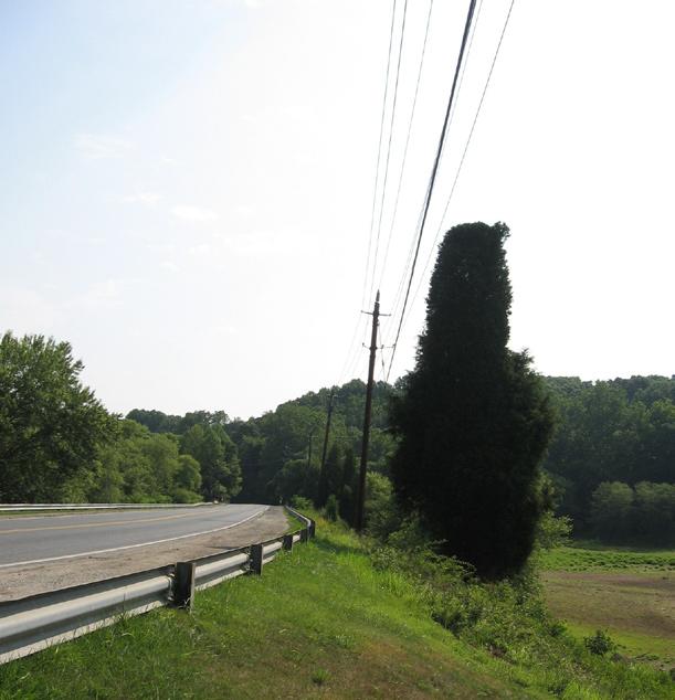
4 Photographs of Needwood Road and Vicinity Needwood Road looking east toward Lake Needwood Needwood Road between ICC and Beach Drive Needwood Road looking south from Muncaster Mill Road Muncaster Mill road looking northwest from Needwood Road Muncaster Mill Roadthrough Rock Creek Park Muncaster Mill Road looking east from Applewood Lane Muncaster Mill Road looking east toward Redland Road Shady Grove Road looking south from Muncaster Mill Road Applewood Lane terminus Muncaster Mill Road looking east from Needwood Road 4 Muncaster Mill Road looking west from Applewood Lane 8 Muncaster Mill Road looking west from Applewood Lane 12 17

5 Figure 4 Needwood Road Options Option 1 Option 2 Option 3 ICC Alignment Existing Bike Route Proposed Bike Route Park Hard Surface Trail Park Natural Surface Trail Roads Proposed Roads M-83 Interchange Wetlands Floodplain Special Protection Areas Parks Metro Stations Railroads Issue Areas 18
6 P R I O R D E C I S I O N S In reviewing the DEIS, the Planning Board and the County Council recommended ending the CBP at Needwood Road, routing the pathway along Needwood, Muncaster Mill, and Shady Grove Roads to connect to the master planned Midcounty Highway path. They also recommended enhancements along Needwood Road to connect the CBP terminus at Needwood Road with the Shady Grove Metrorail Station. R E C O M M E N D A T I O N S Remove the CBP alignment along the old ICC right-of-way between Needwood Road and Shady Grove Road from master plans. Pursue Option 1 to connect the CBP with the up-county trail system and connections to the Shady Grove Metro Station via Needwood Road. R O A D W A Y A N A L Y S I S NEEDWOOD ROAD (ICC TO MUNCASTER MILL ROAD) E X I S T I N G C O N D I T I O N S : Residential Primary, 70-foot right-of-way, two lanes. Shared use path and/or sidewalk exists in short segments along south side from Redland Road to Needwood Mansion. M A S T E R P L A N G U I D A N C E : The 2004 Upper Rock Creek Master Plan calls for a shared use path and on-road bikeway. The CBFMP recommends a dual bikeway, with both bike lanes and a shared use path (DB-14). D I S C U S S I O N : This segment of Needwood Road connects the CBP with Magruder High School and the future community of Bowie Mill Estates. And because the CBP is no longer planned to continue west through the park, it now also must be part of the bike route that links with the Midcounty Highway path, leading to up-county communities east of I-270. Contract A of the ICC highway project will construct the path along the road within the highway right-of-way only. R E C O M M E N D A T I O N : Identify the segment between the ICC and Muncaster Mill Road for inclusion in the County s Annual Bikeway Program, and request matching funding from the State for the short connector. Ensure that the crossing of Muncaster Mill Road to the high school meets AASHTO standards for a shared use path. 19
7 MUNCASTER MILL ROAD (NEEDWOOD ROAD TO SHADY GROVE ROAD) E X I S T I N G C O N D I T I O N S : Arterial (A-93), 80 to100-foot right-of-way, two-four lanes. Shared use path and/or sidewalk exists in short segments along both sides, but SHA most recently constructed a shared use path along the south side near Redland Middle School and near the Redland Roadintersection. M A S T E R P L A N G U I D A N C E : The Upper Rock Creek Master Plan calls for an on-road bikeway. The CBFMP recommends bike lanes (BL-35) for this segment of Muncaster Mill Road. D I S C U S S I O N : This segment of Muncaster Mill Road connects the Needwood Road path with a future path along Shady Grove Road leading to Midcounty Highway, which is master planned to have a shared use path along its south side. In 2005, SHA reconstructed sections of the road, some with a shared use path and some without, including where the road passes through the park. Therefore, constructing a path through the park will need to be a separate project. The road was a major discussion point during the County Council review of the CBFMP, and ultimately the Council voted for only bike lanes and not the shared use path recommended in the Upper Rock Creek Master Plan. Therefore, receiving County funding for the path may prove difficult without a master plan amendment. R E C O M M E N D A T I O N S : Amend the CBFMP to identify the road as a dual bikeway with both bike lanes and a shared use path along the south side, between Needwood Road and Shady Grove Road. Short-term: Pursue the shared use path between Needwood Road and Applewood Lane in a future Capital Improvement Program. Long-term: Link to the future Midcounty Highway path via a signed, shared roadway connection along Applewood Lane, immediately after the interchange is built. Ensure the interchange design and the related Midcounty Highway extension to Shady Grove Road includes a shared use path. SHADY GROVE ROAD (MUNCASTER MILL ROAD TO MIDCOUNTY HIGHWAY) E X I S T I N G C O N D I T I O N S : Major highway (M-42), 120 to 150-foot right-of-way, six lanes divided. Existing five to six foot sidewalk along the entire south side and existing bike lanes. M A S T E R P L A N G U I D A N C E : The 2004 Upper Rock Creek Master Plan doesn t recommend any changes to this configuration. Along with the 2006 Shady Grove Sector Plan and the CBFMP, it recommends bike lanes (BL-30). D I S C U S S I O N : A shared use path would meet the needs of all potential users, but with only 120-feet of right of-way nearest to Muncaster Mill Road, implementing the path without impacting the bike lanes will be extremely difficult. Implementing the shared use path as part of the future Midcounty Highway connection to the ICC interchange (SP-70) is more likely, connecting via Applewood Lane to the future path and bike lanes along Muncaster Mill Road. R E C O M M E N D A T I O N : Do not amend the master plans to add a shared use path along the road. Instead, pursue the path connection along Midcounty Highway and through the interchange to Applewood Lane. 20
8 Study Area B: Emory Lane/Georgia Avenue and Vicinity (Figure 3, C and D) I S S U E S Providing a connection between CBP terminus at Emory Lane with Lake Frank and the Rock Creek Trail system down-county, including a new shared use path along Emory Lane between the ICC and Muncaster Mill Road, as well as along Muncaster Mill Road between Emory Lane and Meadowside Lane. Deciding whether to retain the master planned CBP segment along the ICC right-of-way between Emory Lane and Georgia Avenue. D I S C U S S I O N The connector between the CBP and Lake Frank is technically part of the master planned Rock Creek North Branch Trail. The portion south of Muncaster Mill Road and also north of the ICC in the park is being studied during the Department of Parks Upper Rock Creek Trail Corridor Master Plan. A portion of the park trail north of the ICC will be built by the developer of Bowie Mill Estates. A shared use path is planned for the segment along Emory Lane, and a segment has been constructed between Georgia Avenue and Holly Ridge Lane. The remaining segment between Holly Ridge Road and Muncaster Mill Road is unplanned. Bike lanes are master planned for Muncaster Mill Road in this area, so the trail connector along this road between Emory Lane and Meadowside Lane would be a new master plan recommendation, which is assumed to be part of the planned Rock Creek Trail. The CBP within the ICC right-of-way between Emory Lane and Georgia Avenue was not included in the ICC ROD, but this amendment recommends retaining it in County master plans. Because the highway was not designed with the pathway in this area, the ICC/Georgia Avenue interchange is not designed to provide a grade-separated crossing of Georgia Avenue connecting to the trail on the east side of Georgia Avenue. In the short-term, a controlled crossing is available at Emory Lane. Examining a new crossing is beyond the scope of this master plan amendment and should be the subject of the facility planning study. Even without the grade-separated crossing of Georgia Avenue, the path is valuable. It connects the future shared use path (SP-29) along the Georgia Avenue busway with the Rock Creek Trail system and the CBP heading west. The current shared use path and shared roadway along MD 655 on the west side of Georgia Avenue will be preserved and enhanced as part of ICC Contract A. P R I O R D E C I S I O N S Both the Planning Board and the County Council recommended constructing the CBP with the highway between Emory Lane and Georgia Avenue. There have been no decisions or discussions about how to implement the Rock Creek North Branch Trail between Lake Frank and the ICC Trail. R E C O M M E N D A T I O N S Retain the CBP between Emory Lane and Georgia Avenue in County master plans, recognizing it may be built within or outside the highway right-of-way. Study the grade-separated crossing of Georgia Avenue in a CIP facility planning study. 21
9 Study the Rock Creek Trail segments north of the ICC and south of Muncaster Mill Road in the Department of Parks CIP. Include the park trail connector along Emory Lane and Muncaster Mill Road in a CIP facility planning study to be led by DPWT. Consider coordinating this effort with the park trail connector study identified above. Examine connections to the Meadowside Lane and the WSSC access road along the east side of the stream, south of Muncaster Mill. Minimize impacts to the historic mill site adjacent to the stream and south of Muncaster Mill Road. Study Area C: Northwest Branch Stream Valley Park and Vicinity (Figures 5 and 6) I S S U E S Connecting the CBP terminus at Notley Road (B on figure 5) with the Matthew Henson Trail through the park, as well as with the CBP terminus at Layhill Road (A on figure 5) through the park or along parallel roads. Deciding whether to remove a new trail/bikeway (since it was not built with the highway) parallel to the highway between Notley Road and Alderton Road from County master plans. Deciding whether to remove the CBP parallel to the highway adjoining the Bonifant Woods community between the future Matthew Henson Trail connector and Bonifant Road (figure 5) from County master plans. Studying a new park trail connector that would double as the modified alignment for SP-40 between Bonifant and Layhill roads to and/or through the Trolley Museum site and the future developed park area surrounding it. Deciding whether to accept the State s plan to route the path along parallel roads in conjunction with improvements to these roads that accommodate all user groups. D I S C U S S I O N The ROD did not include the master planned CBP along the ICC right-of-waybetween Notley Road and Layhill Road. SHA s Bike Plan instead recommended an on-road route via existing bikeways along Alderton, Bonifant, and Layhill roads to connect the Matthew Henson Trail with the ICC trail terminus at Layhill Road. It also recommended a future trail connection between Notley Road and Alderton Road (and thus the Matthew Henson Trail heading west) as an area for which the County could partner with the State to study and implement, separate from the highway project. The bicycle and pedestrian routes along the roadway alternatives are adequate for experienced cyclists, but offer an incomplete, discontinuous, or inadequate route for users of other ability levels, most notably the family cyclist. Therefore, this plan evaluates bicycle and pedestrian accommodation along these roads and recommends master plan amendments. A new alignment for SP-40 through the Northwest Branch Park between Layhill Road and Bonifant Road, connecting to and through the Trolley Museum site will be studied in more detail during the Northwest Branch Park Master Plan Update. The primary concern about a shared use path in the Northwest Branch and Vicinity are the sensitive environmental resources south of Bonifant Road, particularly between the Matthew Henson Trail and Notley Road. A path through this area should avoid bisecting the biodiversity area and contiguous forest. 22
TRANSPORTATION PLAN INTRODUCTION TRAVEL FORECASTING
 TRANSPORTATION PLAN INTRODUCTION Most of the Upper Rock Creek Planning Area is within one of the County s rural policy areas; only the Derwood section of the Planning Area is outside this rural classification.
MONTGOMERY COUNTY PLANNING DEPARTMENT THE MARYLAND-NATIONAL CAPITAL PARK AND PLANNING COMMISSION
 MONTGOMERY COUNTY PLANNING DEPARTMENT THE MARYLAND-NATIONAL CAPITAL PARK AND PLANNING COMMISSION SHA CTP Project No. MO891A21, US 29, Fairland Road to Musgrove Road Interchange Improvement, Design Review
Prince George s County plans, policies, and projects
 Prince George s County plans, policies, and projects Over 250 projects for trails, bikeways, designated bike lanes and sidewalk construction Trail projects that improve access to Metro Sidewalk and trail
SHIFTING GEARS. for a better ride ahead. MONTGOMERY COUNTY DEPARTMENT OF TRANSPORTATION April 5, 2014
 SHIFTING GEARS for a better ride ahead MONTGOMERY COUNTY DEPARTMENT OF TRANSPORTATION April 5, 2014 CYCLING IN THE USA The number of bicyclists is growing rapidly in the United States Transportation &
Greater Olney Civic Association
 Greater Olney Civic Association Transportation Committee Bowie Mill Road Bikeway Project Update October 2015 Daniel Rubenstein, Chair Bikeways and Pedestrian Subcommittee GOCA Transportation Committee
CITY OF ELKO BICYCLE AND PATHWAY PLAN
 CITY OF ELKO BICYCLE AND PATHWAY PLAN INTRODUCTION: The City of Elko is intended to provide the basic framework for the development of a functional bicycle and pathway system for the community with connections
TRANSPORTATION PLAN. Goal:
 TRANSPORTATION PLAN Goal: Provide a comprehensive network of roads, transit, and non-motorized access that serves the needs of existing and planned land use in and around Olney, protects environmental
Clackamas County Comprehensive Plan
 ROADWAYS The County s road system permits the movement of goods and people between communities and regions, using any of a variety of modes of travel. Roads provide access to virtually all property. They
Legislative Update. Frederick County Fall Staunton District. Interstate 81 - Exit 300 at Interstate 66 Southbound Acceleration Lane Extension
 Interstate 81 - Exit 300 at Interstate 66 Southbound Acceleration Lane Extension Application ID 1643 Northern Shenandoah Valley Regional Commission (NSVRC) $3,437,423 This project extends the Interstate
section 4 Existing Conditions, Issues, and Options
 section 4 Existing Conditions, Issues, and Options 4.0 Existing Conditions, Issues, and Options This section analyzes each segment of the corridor on a street to street basis. Each segment is discussed
Basalt Creek Transportation Refinement Plan Recommendations
 Basalt Creek Transportation Refinement Plan Recommendations Introduction The Basalt Creek transportation planning effort analyzed future transportation conditions and evaluated alternative strategies for
APPENDIX I BREEZEWAY NETWORK
 APPENDIX I BREEZEWAY NETWORK Breezeways This appendix describes the roadways and trails that comprise each of the proposed corridors in the Breezeway Network, shown below. Breezeways TY UN CO ICK ER ED
EXHIBIT B-1 PROJECT DESCRIPTION. Phase 1 of the Preferred Alternative
 EXHIBIT B-1 PROJECT DESCRIPTION Phase 1 of the Preferred Alternative The Transform 66 Public-Private Partnership (P3) Project (the Project ) means the Phase 1 of the Preferred Alternative components of
Transportation Corridor Studies: Summary of Recommendations
 Transportation Corridor Studies: Summary of Recommendations Route 4 Corridor Study: Route 10 Corridor Study: Route 44 Corridor Study: Route 175 Corridor Study: Route 5/15 Corridor Study: Rentschler Field
MONTGOMERY COUNTY PLANNING DEPARTMENT THE MARYLAND-NATIONAL CAPITAL PARK AND PLANNING COMMISSION
 MONTGOMERY COUNTY PLANNING DEPARTMENT THE MARYLAND-NATIONAL CAPITAL PARK AND PLANNING COMMISSION MCPB Item No. 9 Date: 01-09-14 MD355 Crossing (BRAC) Project, CIP Project 501209, Mandatory Referral No.
3.9 Recreational Trails and Natural Areas
 3.9 Recreational Trails and Natural Areas 3.9.1 Introduction Parks and other recreational facilities such as trails, bicycle routes, and open space are important community resources. This section discusses
Comments EXECUTIVE SUMMARY
 Comments 1. Under any Alternatives, MCDOT should provide better at-grade pedestrian crossing of Georgia Avenue and Forest Glen Road, including improved crosswalks with wider medians and adequate signal
Bicycle and Pedestrian Facilities Toolbox (Excerpt from Figure 3.1)
") Appendix B Neighborhood Connections Summaries This Appendix is a supplement to the information presented in Chapter 3 Connect People. The Appendix includes a summary or profile for each of the proposed
Appendix B Neighborhood Connections Summaries This Appendix is a supplement to the information presented in Chapter 3 Connect People. The Appendix includes a summary or profile for each of the proposed
Proposed White Flint Separated Bike Lane Network September 2015
 Proposed White Flint Separated Bike Lane Network September 2015 Abstract This report includes a proposed separated bike lane network for the White Flint Sector Plan area. Separated bike lanes create a
01. VICINITY OF GREENBRAE POC: EXISTING CONDITIONS
 01. VICINITY OF GREENBRAE POC: EXISTING CONDITIONS Existing Bus Stop Existing US101 On-ramp Existing POC Old Redwood Highway Rich Street City ROW Environmental Study Limit Industrial Way NO DESIGNATED
Description of Planning Board Recommended Network
 I-270 Corridor Interchanges Frederick (MD 355) at Ridge (MD 1 27) New Interchange N/A N/A N/A X X n/a $ 66 2 I-270 at Clopper (MD 117) Upgrade Interchange, Include Park-and-Ride Lot N/A N/A N/A X X X n/a
MOUNTAIN HOUSE SPECIFIC PLAN I 9.1 INTRODUCTION ASSUMPTIONS TRANSPORTATION FACILITIES TRANSPORTATION IMPROVEMENTS PHASING 9.
 CHAPTER NINE: TRANSPORTATION AND CIRCULATION 9.1 INTRODUCTION 9.1 9.2 ASSUMPTIONS 9.1 9.3 TRANSPORTATION FACILITIES 9.1 9.4 TRANSPORTATION IMPROVEMENTS PHASING 9.3 LIST OF FIGURES LIST OF TABLES Figure
5 CIRCULATION AND STREET DESIGN
 5 CIRCULATION AND STREET DESIGN This chapter describes circulation and streetscape improvements proposed for the Northwest Chico Specific Plan Area. It includes detailed design specifications for existing
4. ENVIRONMENTAL IMPACT ANALYSIS 9. TRANSPORTATION AND TRAFFIC
 4. ENVIRONMENTAL IMPACT ANALYSIS 9. TRANSPORTATION AND TRAFFIC 4.9.1 INTRODUCTION The following section addresses the Proposed Project s impact on transportation and traffic based on the Traffic Study
Chapter 5 Future Transportation
 Chapter 5 Future Transportation The Future Land Use Plan identifies the desired land use designations. The land uses desired for Crozet depend, in large part, on the success of the transportation system,
2014 Mobility Assessment Report Functional Planning & Policy Montgomery County Planning Department
 2014 Mobility Assessment Report Functional Planning & Policy Montgomery County Planning Department Travel Trends National & Local Travel Trends Multi-Modal Monitoring Pedestrian Bikes Bus Rail Future Efforts
MONTGOMERY COUNTY PLANNING DEPARTMENT THE MARYLAND-NATIONAL CAPITAL PARK AND PLANNING COMMISSION
 MONTGOMERY COUNTY PLANNING DEPARTMENT THE MARYLAND-NATIONAL CAPITAL PARK AND PLANNING COMMISSION MCPB Item No. 4 Date: 04-17-14 2014 Mobility Assessment Report José Dory, Senior Planner, Functional Planning
2012 Capital Budget Capital Improvement Program
 2012 Capital Budget Capital Improvement Program Agency Name: Eng. - Bicycle and Pedestrian Agency Number: 53L Capital Budget Future Year Estimates Project Name 2012 2013 2014 2015 2016 2017 1 Bikeways
APPENDIX G: INTERSECTION NEEDS AT OKEECHOBEE BOULEVARD
 APPENDIX G: INTERSECTION NEEDS AT OKEECHOBEE BOULEVARD INTERSECTION NEEDS AT SR 7 and OKEECHOBEE BOULEVARD SR 7 Extension Project Development and Environment (PD&E) Study From Okeechobee Boulevard (SR
Montgomery County Life Sciences Center. LOOP TRAIL GSSC Implementation Advisory Committee Meeting #2 March 26, 2015
 Montgomery County Life Sciences Center LOOP TRAIL GSSC Implementation Advisory Committee Meeting #2 March 26, 2015 Trail Alternatives GENERAL ASSUMPTIONS Where separated bicycle and pedestrian facilities
BICYCLE AND TRAILS ADVISORY COMMISSION Meeting Minutes
 Minutes Approved as Submitted Date: 8/10/17 Initials: EC BICYCLE AND TRAILS ADVISORY COMMISSION Meeting Minutes June 8, 2017 The Bicycle and Trails Advisory Commission was called to order at 4:00 p.m.
TABLE OF CONTENTS. Executive Summary
 Executive Summary Background... ES-1 Pedestrian Network... ES-2 Bikeway Network... ES-2 Collision History... ES-2 Public Input... ES-4 Conclusions and Recommendations... ES-4 1. Introduction and Setting
TRANSPORTATION & MOBILITY
 TRANSPORTATION & MOBILITY ROADWAY SYSTEM There are approximately 40 miles of roadways in Manitou Springs. For planning purposes, roadways are typically assigned a functional classification which defines
ACTION TRANSMITTAL No
 Transportation Advisory Board of the Metropolitan Council of the Twin Cities ACTION TRANSMITTAL No. 2016-15 DATE: January 14, 2016 TO: TAC Planning Committee PREPARED BY: Steven Elmer (651) 602-1756 SUBJECT:
MONTGOMERY COUNTY PLANNING DEPARTMENT
 MONTGOMERY COUNTY PLANNING DEPARTMENT THE MARYLAND-NATIONAL CAPITAL PARK AND PLANNING COMMISSION MCPB Item No Date: 6-07-2018 MD355 Over Little Bennett Creek Bridge Replacement (SHA Project No. MO4275180),
Golden s Plan. For the Highway 6 & 93 Corridor
 Golden s Plan For the Highway 6 & 93 Corridor Purpose of the Study Accommodate regional traffic needs on Highways 6 and 93, as defined by the Northwest Quadrant Feasibility Study. Find a solution that
Non-Motorized Transportation 7-1
 Non-Motorized Transportation 7-1 Transportation facilities no longer mean just accommodating a vehicle powered by a combustion engine. Pedestrian and non-motorized facilities are important modes of travel
Appendix D: Concept Screening
 Concept Description Concept #1 Route 288 Roadway Widening This concept consists of constructing a third lane on northbound and southbound Route 288 between Powhite Parkway and US 360. This improvement
SANTA CLARA COUNTYWIDE BICYCLE PLAN August 2008
 SANTA CLARA COUNTYWIDE BICYCLE PLAN August 2008 To assist VTA and Member Agencies in the planning, development and programming of bicycle improvements in Santa Clara County. Vision Statement To establish,
C C C
 C-012-001 Thank you for your support for the creation of new public space and nonmotorized access between downtown and the waterfront through the Overlook Walk, the East-West Connections, and the Promenade.
Living Streets Policy
 Living Streets Policy Introduction Living streets balance the needs of motorists, bicyclists, pedestrians and transit riders in ways that promote safety and convenience, enhance community identity, create
December For more information, call the Area 2 Division at (301)
") December 2013 Appendix B: Transportation Analysis For more information, call the Area 2 Division at (301) 495-4500 GLENMONT SECTOR PLAN TRANSPORTATION APPENDIX November 8, 2013 1 Contents Purpose Transportation
December 2013 Appendix B: Transportation Analysis For more information, call the Area 2 Division at (301) 495-4500 GLENMONT SECTOR PLAN TRANSPORTATION APPENDIX November 8, 2013 1 Contents Purpose Transportation
Attachment A. Attachment A Master Plan History and Environmental Legislation Master Plan of Highways
 Attachment A Attachment A Master Plan History and Environmental Legislation 1955 Master Plan of Highways The 1955 Master Plan of Highways did not include the Midcounty Highway because M-NCPPC s jurisdiction,
Fitting Light Rail through Well-established Communities
 Fitting Light Rail through Well-established Communities San Francisco 2008 Michael D. Madden Chief, Project Development, Maryland Transit Administration Project Setting Located inside the Capital Beltway
WHEREAS, the New Jersey Department of Transportation' s Complete Streets
 WHEREAS, the State Department of Transportation adopted a Complete Streets Policy ( Policy No. 703), effective December 3, 2009, for all projects funded through the Department' s Capital Program and strongly
10A. DATE: October 5, Pedestrian and Bicycle Advisory Committee. Kevin Colin, Deputy Planning Manager Curt Bates, City Engineer
 10A DATE: October 5, 2016 TO: PREPARED BY: SUBJECT: Pedestrian and Bicycle Advisory Committee Kevin Colin, Deputy Planning Manager Curt Bates, City Engineer Discussion and Provide Comments, Associated
ACTIVE TRANSPORTATION/NONMOTORIZED TRANSPORTATION
 ACTIVE TRANSPORTATION/NONMOTORIZED TRANSPORTATION BACKGROUND Active transportation, also known as nonmotorized transportation, is increasingly recognized as an important consideration when planning and
Southwest Bus Rapid Transit (SW BRT) Functional Planning Study - Executive Summary January 19 LPT ATTACHMENT 2.
 Functional Planning Study - Executive Summary January 19 LPT ATTACHMENT 2.") Southwest Bus Rapid Transit (SW BRT) Functional Planning Study - Executive Summary 2011 January 19 1 of 19 Introduction This executive summary presents the results of the Southwest Bus Rapid Transit (SW
Southwest Bus Rapid Transit (SW BRT) Functional Planning Study - Executive Summary 2011 January 19 1 of 19 Introduction This executive summary presents the results of the Southwest Bus Rapid Transit (SW
MONTGOMERY COUNTY PLANNING DEPARTMENT THE MARYLAND-NATIONAL CAPITAL PARK AND PLANNING COMMISSION
 MONTGOMERY COUNTY PLANNING DEPARTMENT THE MARYLAND-NATIONAL CAPITAL PARK AND PLANNING COMMISSION MCPB Item No. 4 Date: 09-10-15 Scope of Work for the Bicycle Master Plan David Anspacher, Planner/Coordinator,
SR-203 Sidewalks and Town-Wide Mobility Improvements. Town Council Presentation September 7, 2016
 SR-203 Sidewalks and Town-Wide Mobility Improvements Town Council Presentation September 7, 2016 SR-203 Sidewalks and Town- Wide Mobility Improvements SR-203 Sidewalks and Appurtenances Town-Wide Mobility
Approximately 360 trail users cross during a typical summer weekday and 420 cross during a typical summer
 5. PARKR ROAD AT MISSISSIPPI AVN CROSSIN xisting Conditions The High ine Canal trail crosses Parker Road near the Mississippi Avenue intersection (crossing location #3 on Figure 1). South of Parker, the
Facility Planning Process The facility planning process included the following sequence of work:
 The trail will extend the Clarksburg Greenway hard surface trail and the MD Route 355 hikerbiker trail north towards Hyattstown; provide pedestrian access from the Clarksburg Town Center to the Little
Solana Beach Comprehensive Active Transportation Strategy (CATS)
") Solana Beach Comprehensive Active Transportation Strategy (CATS) 3.0 Goals & Policies The Solana Beach CATS goals and objectives outlined below were largely drawn from the Solana Beach Circulation Element
Solana Beach Comprehensive Active Transportation Strategy (CATS) 3.0 Goals & Policies The Solana Beach CATS goals and objectives outlined below were largely drawn from the Solana Beach Circulation Element
Route 29 Solutions Projects
 Route 29 Solutions Route 29 Solutions Projects www.route29solutions.org October 10, 2014 Route 29 Widening to Six Lanes Albemarle County This project will widen a 1.8-mile segment of Route 29 from four
Ownership Lots 17 & 18 (Part of Lot 14), Montgomery Auto Sales Park
, Montgomery Auto Sales Park") Traffic Impact Analysis Ownership Lots 17 & 18 (Part of Lot 14), Montgomery Auto Sales Park Silver Spring, MD Lot 17: Site Plan No. 821413 Lot 18: Site Plan No. 821414 Filing Number: 13-TS-1198527A Prepared
Traffic Impact Analysis Ownership Lots 17 & 18 (Part of Lot 14), Montgomery Auto Sales Park Silver Spring, MD Lot 17: Site Plan No. 821413 Lot 18: Site Plan No. 821414 Filing Number: 13-TS-1198527A Prepared
Perryville TOD and Greenway Plan
 Perryville TOD and Greenway Plan Greenway Glossary Pathway: A bicycle and pedestrian path separated from motorized vehicular traffic by an open space, barrier or curb. Multi-use paths may be within the
APPENDIX 14: CONNECTIONS: TRANSPORTATION ANALYSIS. Transportation Planning, Analysis
 APPENDIX 14: CONNECTIONS: TRANSPORTATION ANALYSIS Transportation Planning, 2008 Germantown has various options of transportation for citizens in the community. There are major highways, buses, MARC, bicycle
Engineering - Bicycle and Pedestrian
 Capital Improvement Plan Project Summary # Bikeways Program 781,000 860,000 900,000 933,000 933,000 933,000 # Cannonball Path 1,200,000-780,000 - - - # Capital City Trail - 70,000 - - 910,000 - # Goodman
Prioritization of Bicycle Supportive Laws, Regulations and Policies. Recommended Expanded Bicycle-Supportive Programs
 1) Table of Contents, Add these subsections: s Bicycle Facility Classifications General Application Breezeway Network Recommendations Bicycle Parking Short-Term Bicycle Parking Long-Term Bicycle Parking
Chapter 7 Nonmotorized Facilities
 Chapter 7 Nonmotorized Facilities What is in this chapter? This chapter discusses existing and proposed pedestrian and bicycle facilities referred to as nonmotorized facilities along the SR 520 corridor.
State Highway 16 Kuna-Mora Road to Ada/Gem County Line
 Background Update! (February 2018): This project has been partially funded; see below. State Highway 16 is the main commuter route from Gem County to the Treasure Valley. An increase in traffic and accidents
Stakeholders Advisory Working Groups (SAWGs) Bridge and Bike / Pedestrian SAWG (#15)
 Bridge and Bike / Pedestrian SAWG (#15)") Presentation Bridge and Bike / Pedestrian SAWG (#15) Tappan Zee Bridge/I-287 Corridor Project December 8, 2009 Slide 1. This is the title slide for the Tappan Zee Bridge Joint Stakeholders Advisory Working
Presentation Bridge and Bike / Pedestrian SAWG (#15) Tappan Zee Bridge/I-287 Corridor Project December 8, 2009 Slide 1. This is the title slide for the Tappan Zee Bridge Joint Stakeholders Advisory Working
FI-2 I-66 Between Route 29, Lee Highway and Route 15, James Madison Highway
 TRANSPORTATION PLAN INTENT Transportation is the key to the economic and social development of Prince William County and especially to the I 66/Route 29 Sector Plan area. This includes transportation for
Lee s Summit Road Improvement Study Public Open House June 7, 2007 Summary of Comment Card Responses
 Lee s Summit Road Improvement Study Public Open House June 7, 2007 Summary of Comment Card Responses Introduction At the Lee s Summit Road Improvement Study Public Open House held Thursday, June 7, 2007
City of Madison: 2017 Capital Budget Capital Improvement Plan
 Capital Improvement Plan Project Summary Bikeways Program 779,000 751,000 630,000 670,000 703,000 703,000 Cannonball Path 210,000 - - 730,000 - - Cap City Trail 1,140,000-360,000 - - 910,000 Ice Age Junction
AGENDA REPORT. Issue: Discussion of potential improvements on Barnwell Road at Niblick Drive
 AGENDA REPORT To: From: By: Honorable Mayor and City Council Members Warren Hutmacher, City Manager Tom Black, Public Works Director Date: March 23, 2016 Agenda: March 28, 2016 WORK SESSION AGENDA: Barnwell
Circulation in Elk Grove includes: Motor vehicles, including cars and trucks
 Circulation, as it is used in this General Plan, refers to the many ways people and goods move from place to place in Elk Grove and the region. Circulation in Elk Grove includes: Motor vehicles, including
DESIGN MEMORANDUM WITH DESIGN EXCEPTIONS SP SP
 DRAFT NOT FINAL (Note: document was not finalized due to an eastbound stopping site distance design issue that requires more detailed bridge and roadway design considerations. This discussion starts on
City of Hyattsville. Citywide Traffic Study and Transportation Plan. Sabra, Wang & Associates. February, 2010
 City of Hyattsville Citywide Traffic Study and Transportation Plan February, 2010 Outline Existing Conditions Recommendations Future Conditions Traffic Growth Development Capacity and Level of Service
Improving Cyclist Safety at the Dundas Street West and Sterling Road Intersection
 STAFF REPORT ACTION REQUIRED Improving Cyclist Safety at the Dundas Street West and Sterling Road Intersection Date: August 17, 2012 To: From: Wards: Reference Number: Public Works and Infrastructure Committee
Design of Stanley Park S-Curve
 ADMINISTRATIVE REPORT Date: May 4, 2001 TO: FROM: Author/Local: F. Klotzbach/7118 RTS NO. 01644 CC File No. Standing Committee on Transportation and Traffic General Manager of Engineering Services, in
West Dimond Blvd Upgrade Jodhpur Street to Sand Lake Road
 West Dimond Blvd Jodhpur St to Sand Lake CSS Transportation Project Summary Municipality of Anchorage Project # 05 005 Project Manager: John Smith, P.E. (MOA PM&E) Project Administrator: Julie Makela,
SOLANA BEACH BICYCLE TRANSPORTATION PLAN SECOND ADDENDUM
 SOLANA BEACH BICYCLE TRANSPORTATION PLAN SECOND ADDENDUM Prepared by the City of Solana Beach January 2005 Introduction In June of 1993, the Solana Beach City Council adopted a Bikeway Master Plan as directed
2.0 Existing Conditions
 20 2.0 Existing Conditions 2.1 Land Use, Future Growth Patterns, Physical Barriers Geographic Overview Sutter County s land use pattern is characterized by extensive agricultural areas, significant natural
MONTGOMERY COUNTY COUNCIL
 MONTGOMERY COUNTY COUNCIL R O C K V I L L E, M A R Y L A N D October 20, 2015 The Honorable Isiah Leggett Montgomery County Executive 101 Monroe Street, 2nd Floor Rockville, MD 20850 Dear County Executive
Montgomery County Life Sciences Center Loop Trail
 Montgomery County Life Sciences Center Loop Trail Advisory Committee Meeting #1 February 10, 2015 Agenda 1. Project Background 2. Existing Conditions Analysis 3. Examples from Elsewhere 4. Discussion Project
MONTGOMERY COUNTY PLANNING DEPARTMENT
 MONTGOMERY COUNTY PLANNING DEPARTMENT THE MARYLAND-NATIONAL CAPITAL PARK AND PLANNING COMMISSION MCPB Item No. 6 Date: 03-08-2018 Bicycle Master Plan Public Hearing Draft Work Session #4 David Anspacher,
MONTGOMERY COUNTY PLANNING DEPARTMENT THE MARYLAND-NATIONAL CAPITAL PARK AND PLANNING COMMISSION
 MONTGOMERY COUNTY PLANNING DEPARTMENT THE MARYLAND-NATIONAL CAPITAL PARK AND PLANNING COMMISSION MCPB Item No. 5 Date: 12/3/15 Draft White Flint Separated Bike Lanes Network David Anspacher, Functional
CONNECTING PEOPLE TO PLACES
 CONNECTING PEOPLE TO PLACES 82 EAST BENCH MASTER PLAN 07 Introduction The East Bench transportation system is a collection of slow moving, treelined residential streets and major arteries that are the
ECONOMY PEOPLE ENVIRONMENT
 Report Back on Local Transit Improvements May 29, 2013 ECONOMY PEOPLE ENVIRONMENT Intro Council Requested Report Back Topics Progress on Planning for Broadway Subway False Creek Bridges Local Transit Improvements
State Highway 16 Kuna-Mora Road to Ada/Gem County Line
 Background State Highway 16 is the main commuter route from Gem County to the Treasure Valley. An increase in traffic and accidents on this highway have been a concern for several years, and the Idaho
Portland International Airport Bicycle and Pedestrian Plan (October 2003) Staff Acknowledgements
 Staff Acknowledgements") Portland International Airport Bicycle and Pedestrian Plan (October 2003) Staff Acknowledgements Scott King, Senior Aviation Planner Jason Gately, Senior Aviation Planner Preston Beck, Associate Planner
Portland International Airport Bicycle and Pedestrian Plan (October 2003) Staff Acknowledgements Scott King, Senior Aviation Planner Jason Gately, Senior Aviation Planner Preston Beck, Associate Planner
1. What is the Doran Street and Broadway/Brazil Grade Separation Project (Project)?
?") 1. What is the Doran Street and Broadway/Brazil Grade Separation Project (Project)? The Los Angeles County Metropolitan Transportation Authority (Metro) is evaluating the development of a grade separation
1. What is the Doran Street and Broadway/Brazil Grade Separation Project (Project)? The Los Angeles County Metropolitan Transportation Authority (Metro) is evaluating the development of a grade separation
Preliminary Transportation Analysis
 Preliminary Transportation Analysis Goals of a Robust, Multimodal Transportation Network Safe Accessible/Connected Efficient Comfortable Context-Sensitive Motor Vehicle: Continue to analyze the data to
MAG Town of Cave Creek Bike Study Task 6 Executive Summary and Regional Significance Report
 Page 1 MAG Town of Cave Creek Bike Study Task 6 Executive Summary and Regional Significance Report August 1, 2012 MAG Project #481 Page 2 Task 6 Executive Summary and Regional Significance Report Introduction
State Highway 16/McDermott Road Kuna-Mora Road to Ada/Gem County Line
 Background State Highway 16 is the main commuter route from Gem County to the Treasure Valley. An increase in traffic and accidents on this highway have been a concern for several years, and the Idaho
Madison Urban Area and Dane County. Bicycle Transportation Plan Summary. September Introduction. Bicycle Plan Scope and Planning Process
 Bicycle Transportation Plan Summary Madison Urban Area and Dane County Introduction September 2000 Bicycling is an important mode of transportation in the Madison urban area and countywide that is available
Recommended Roadway Plan Section 2 - Land Development and Roadway Access
 Recommended Roadway Plan Section 2 - Land Development and Roadway Access SECTION 2 Land Development and Roadway Access 2.1 Land Use and Access Management The Federal Highway Administration (FHWA) defines
Parks, Open Space, Trails and Recreation Master Plan
 5.3 DEFINITIONS AND VOCABULARY In order to fully understand the range of trails that have been developed, and should be developed, throughout the community, a vocabulary needs to be established for the
Environmental Assessment Findings & Recommendations. Public Hearing November 13, 2014
 Environmental Assessment Findings & Recommendations Public Hearing November 13, 2014 Welcome! Welcome and Introductions Project and Environmental Assessment Overview Public Comments Adjourn Purpose of
Third Street Bridge & Corridor Project
 Third Street Bridge & Corridor Project Preparation for the FY2018 budget to commence October 1, 2017, includes funding to address a project that has been considered since 1994. The Third Street bridge
City of Saline. Complete Streets Ordinance
 City of Saline Complete Streets Ordinance September 13 and 20, 2010 CARLISLE/WORTMAN ASSOCIATES What Are Complete Streets? Complete streets are designed to serve everyonemotorists as well as pedestrians
Welcome to the Sellwood Bridge Project Open House!
 Welcome to the Sellwood Bridge Project Open House! 5:30 7:30 pm Please sign in here Information stations and project staff are located throughout the room. Goals for Tonight s Meeting: Learn how the Preferred
Building Great Neighbourhoods BONNIE DOON
 Building Great Neighbourhoods BONNIE DOON We Are Here Today To Explain the Neighbourhood Renewal Process Show you the Westwood Preliminary Design Ask for local knowledge Highlight the Local Improvement
TRANSPORTATION TRAINING TOPICS. April 6, 2010
 TRANSPORTATION TRAINING TOPICS April 6, 2010 Roles of Transportation Providers Context and Policy Makers Division of Transportation and Traffic Other City Operations Other Transportation Operators CMA
I-90 ALLSTON INTERCHANGE A MULTIMODAL TRANSPORTATION PROJECT MEPA CONSULTATION MEETING NOVEMBER 20, 2014 BRIGHTON HIGH SCHOOL
 I-90 ALLSTON INTERCHANGE A MULTIMODAL TRANSPORTATION PROJECT MEPA CONSULTATION MEETING NOVEMBER 20, 2014 BRIGHTON HIGH SCHOOL Today s Agenda 1. 2. 3. 4. 5. Overview of the MEPA Process Project Overview
NEW BRAUNFELS SEGUIN AREA REGIONAL TRANSPORTATION DRAFT PLAN NEW BRAUNFELS CITY COUNCIL MEETING
 NEW BRAUNFELS SEGUIN AREA REGIONAL TRANSPORTATION DRAFT PLAN NEW BRAUNFELS CITY COUNCIL MEETING February 13, 2012 This regional transportation plan will: 1. Review existing plans for the cities and counties,
Town of Bethlehem. Planning Assessment. Bethlehem Town Board
 Town of Bethlehem US 9W Corridor Transportation Planning Assessment Presented e to: Bethlehem Town Board June 2009 Overview Study Background Route 9W Corridor Conditions and Improvements Selkirk Bypass
TRANSPORTATION AND CIRCULATION
 TRANSPORTATION AND CIRCULATION The plan reinforces the City of College Park s vision for US 1 becoming a revitalized gateway boulevard. Emphasis has been placed on the pedestrian quality of a new streetscape
MCPB Item No. 5 Date: White Flint West Transportation, Phase 2, CIP No , Mandatory Referral No. MR
 MONTGOMERY COUNTY PLANNING DEPARTMENT THE MARYLAND-NATIONAL CAPITAL PARK AND PLANNING COMMISSION MCPB Item No. 5 Date: 09-10-15 White Flint West Transportation, Phase 2, CIP No. 501116, Mandatory Referral