Golden s Plan. For the Highway 6 & 93 Corridor
|
|
|
- Lester Welch
- 5 years ago
- Views:
Transcription


1 Golden s Plan For the Highway 6 & 93 Corridor
.")


2 Purpose of the Study Accommodate regional traffic needs on Highways 6 and 93, as defined by the Northwest Quadrant Feasibility Study. Find a solution that meets community goals and addresses community concerns. Keep costs reasonable ($35 million per mile or less). Study Process Realigned Highway 93 In August 2002, Golden hired Muller Engineering to study and develop improvements to Highways 6 and 93. All aspects of this study were centered around community input. The City sponsored nine public meetings to provide residents the opportunity to weigh in on the designs. Hundreds of citizens participated and generated over 2,300 documented comments which all factored into the final design. Citizen groups were also represented at design team progress meetings. The Project Timeline Fall 2002: Held three public open houses to solicit citizen input and establish project goals. Winter/Spring 2003: Developed design alternatives around public feedback. Summer 2003: Held two open houses to present design alternatives to the public for comment, which resulted in final recommendations. Late Summer 2003: Presented Recommended Preferred Alternative to Golden City Council. Held four open houses to present the Recommended Preferred Alternative to the public for comments. October 23, 2003: Golden City Council adopted the Recommended Preferred Alternative Golden s Plan by unanimous vote (7 to 0). Typical noise barrier and bike path to mitigate neighborhood impacts


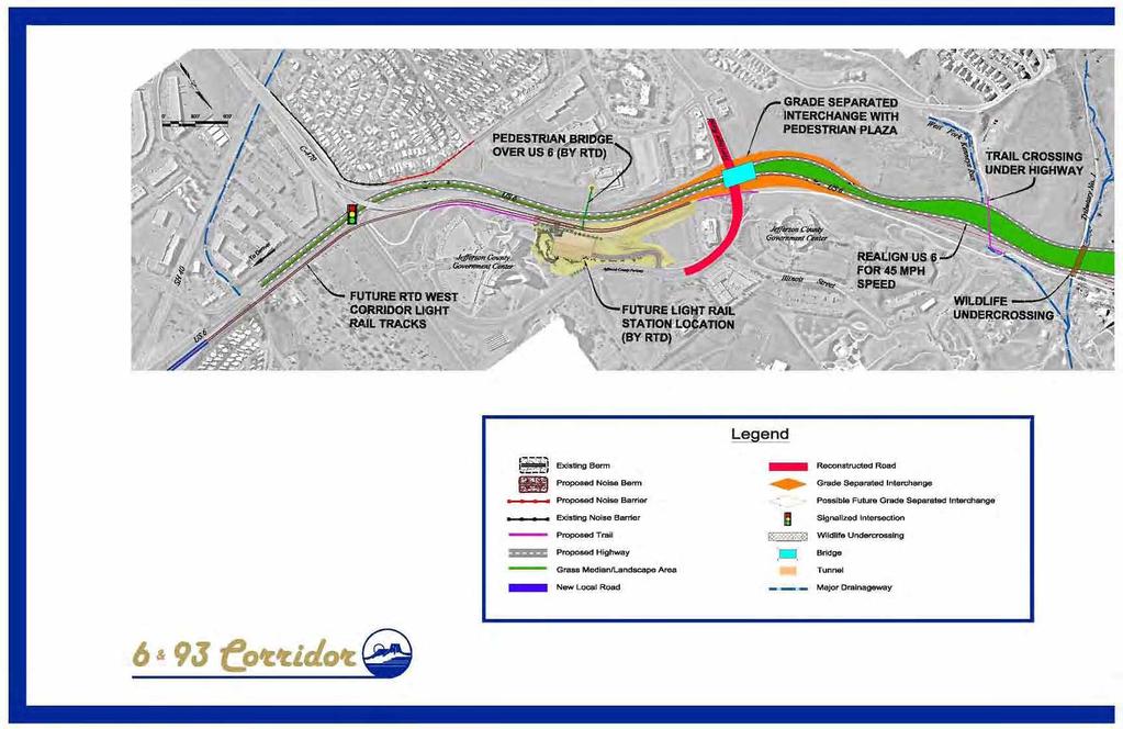
3 Community Goals The community s overarching goal was to build a road that is consistent with Golden s natural, historic, and community characteristics. To that end, citizens agreed upon three primary community-related goals: Realigned U.S. 6 Transportation Goals The Northwest Quadrant Feasibility Study (NWQFS) outlined the set of regional transportation improvements needed to increase mobility in Northwest Jefferson County over the next 20 years. Golden s Plan for the Highway 6 and 93 Corridor was developed to illustrate the transportation facility required to meet the recommendations of the NWQFS for Highways 6 and 93, including: Widen the corridor to 4 lanes. Improve safety. Accommodate the traffic volumes anticipated in ,000 vehicles per day on 6. 40,000 vehicles per day on 93. Make it easy to accommodate increased traffic volumes beyond Accommodate multiple modes of travel. 1. Minimize Noise Reduce average noise levels in yards adjacent to the highway to 55 decibels or less. (55 decibels is approximately the background noise level of two or three people having a friendly conversation in a living room.) Make the roadway design speed 45 mph. 2. Enhance Neighborhood Connectivity Make the corridor friendly to pedestrians and bicyclists. Connect neighborhoods, schools and parks that are currently separated by the highway. 3. Protect the Natural and Historic Beauty of the Mountain Backdrop Preserve views of the mountains and valley from the road. Reduce views of the highway from homes. Typical Transparent Noise Barrier to preserve views. Tunnel to ensure neighborhood connectivity. Typical Pedestrian Plaza at Grade-Separated Interchange (Highway is beneath pedestrian plaza).
4


5 Plan For US 6 To Black Hawk/ Central City To Boulder
 GRADE SEPARATED INTERCHANGE 580 FOOT TUNNEL TO ENSURE NEIGHBORHOOD CONNECTIVITY (IOWA STREET PASSES OVER TUNNEL) PEDESTRIAN BRIDGE To Denver SEE US 6 GRAPHIC EXISTING PEDESTRIAN")
6 TRAFFIC SIGNAL (POSSIBLE FUTURE GRADE SEPARATION AS TRAFFIC NEEDS DICTATE) TRAFFIC SIGNAL (POSSIBLE FUTURE GRADE SEPARATED INTERCHANGE AS TRAFFIC NEEDS DICTATE) PEDESTRIAN TRAIL ALONGSIDE TUCKER GULCH (UNDER SH 93) GRADE SEPARATED INTERCHANGE 580 FOOT TUNNEL TO ENSURE NEIGHBORHOOD CONNECTIVITY (IOWA STREET PASSES OVER TUNNEL) PEDESTRIAN BRIDGE To Denver SEE US 6 GRAPHIC EXISTING PEDESTRIAN BRIDGE (TO REMAIN) EXISTING PEDESTRIAN BRIDGE (TO BE RECONSTRUCTED)
 To Boulder Plan")
7 WILDLIFE UNDERCROSSING TRAFFIC SIGNAL (POSSIBLE FUTURE GRADE SEPARATED INTERCHANGE AS TRAFFIC NEEDS DICTATE) To Boulder Plan For SH 93
Municipal Class EA To Address Traffic Congestion On The Ontario Street Corridor (Grand Bend) Public Information Meeting June 4, 2018
 Public Information Meeting June 4, 2018") Municipal Class EA To Address Traffic Congestion On The Ontario Street Corridor (Grand Bend) Public Information Meeting June 4, 2018 Background Agenda Traffic Study Update Class EA Alternatives Bridge
Municipal Class EA To Address Traffic Congestion On The Ontario Street Corridor (Grand Bend) Public Information Meeting June 4, 2018 Background Agenda Traffic Study Update Class EA Alternatives Bridge
Route 29 Solutions Projects
 Route 29 Solutions Route 29 Solutions Projects www.route29solutions.org October 10, 2014 Route 29 Widening to Six Lanes Albemarle County This project will widen a 1.8-mile segment of Route 29 from four
VDOT I-66 Inside the Beltway Eastbound Widening Environmental Assessment. Staff Recommendations
 VDOT I-66 Inside the Beltway Eastbound Widening Environmental Assessment Staff Recommendations Department of Environmental Services Transportation January 28, 2017 Timeline of Transform66 June 2012: I-66
3.9 Recreational Trails and Natural Areas
 3.9 Recreational Trails and Natural Areas 3.9.1 Introduction Parks and other recreational facilities such as trails, bicycle routes, and open space are important community resources. This section discusses
Giles Run Connector Road
 Giles Run Connector Road Laurel Hill Adaptive Reuse Area to Laurel Crest Drive South County Federation Meeting June 14, 2016 History Connector road included in the Laurel Hill Comprehensive Plan amendment
TABLE OF CONTENTS. Executive Summary
 Executive Summary Background... ES-1 Pedestrian Network... ES-2 Bikeway Network... ES-2 Collision History... ES-2 Public Input... ES-4 Conclusions and Recommendations... ES-4 1. Introduction and Setting
Owl Canyon Corridor Project Overview and Summary
 Owl Canyon Corridor Project Overview and Summary December 22, 2008 The Owl Canyon corridor (generally the connection between the I-25 / Larimer County Road 70 interchange and the US 287 / Larimer County
Welcome. Thank you for your interest in the Lewis & Clark Viaduct Concept Study
 Welcome Thank you for your interest in the Lewis & Clark Viaduct Concept Study Please use the arrows in the upper left hand corner to navigate through the presentation. Use the envelope icon to ask a question
!!!!!!!!!!!!!!!!!! Metro!Denver!MTD!Governance!Committee! October!23,!2013!!9:00!AM!to!10:00!AM! Denver!Regional!Council!of!Governments!
 MetroDenverMTDGovernanceCommittee October23,2013 9:00AMto10:00AM DenverRegionalCouncilofGovernments MeetingRecord MetroDenverMTDGovernanceCommittee October23,2013 9:00AM Agenda: 9:00AM Welcome&Introductions
4. ENVIRONMENTAL IMPACT ANALYSIS 9. TRANSPORTATION AND TRAFFIC
 4. ENVIRONMENTAL IMPACT ANALYSIS 9. TRANSPORTATION AND TRAFFIC 4.9.1 INTRODUCTION The following section addresses the Proposed Project s impact on transportation and traffic based on the Traffic Study
RiNo Railroad Crossing Connectivity Analysis. Stakeholder Workshop June 29, 2017
 RiNo Railroad Crossing Connectivity Analysis Stakeholder Workshop June 29, 2017 Ideas and Considerations Presented at Stakeholder Workshop Primary Focus: 38 th Street (between Walnut & Wynkoop) 1 Basic
APPENDIX A. GIS ANALYSIS FOR THE MRT
 APPENDIX A. GIS ANALYSIS FOR THE MRT The Iowa Mississippi River Trail plan was created through a data-driven analysis using geographic information systems. GIS integrates map images with relevant data,
Executive Summary. September 3, 2014
 D Executive Summary September 3, 2014 Study Background and Purpose Citizens for Picture Rocks is a community advocacy group representing the Picture Rocks Fire Department, Pima County Sheriff s Department,
7th Street Bridge Project. Public Presentation February 24, :30pm-8pm
 7th Street Bridge Project Public Presentation February 24, 2014 6:30pm-8pm Public Meeting Agenda Welcome and introductions Judith Buethe Opening remarks - David Leamon, PE/Hans Strandgaard, PE Project
Saskatchewan Drive Roadway Rehabilitation and Shared-Use Path Widening
 Saskatchewan Drive Roadway Rehabilitation and Shared-Use Path Widening We are here today to present the draft plan for the Saskatchewan Drive Roadway Rehabilitation and Shared-Use Path Widening project
ARLINGTON COUNTY, VIRGINIA
 ARLINGTON COUNTY, VIRGINIA County Board Agenda Item Meeting of October 15, 2016 DATE: October 7, 2016 SUBJECT: Adoption of amendments to the Master Transportation Plan (MTP) to create a new Pedestrian
Tonight is for you. Learn everything you can. Share all your ideas.
 Strathcona Neighbourhood Renewal Draft Concept Design Tonight is for you. Learn everything you can. Share all your ideas. What is Neighbourhood Renewal? Creating a design with you for your neighbourhood.
State Highway 16 Kuna-Mora Road to Ada/Gem County Line
 Background State Highway 16 is the main commuter route from Gem County to the Treasure Valley. An increase in traffic and accidents on this highway have been a concern for several years, and the Idaho
Fairfax County Parkway Widening Fairfax County
 Get Involved VDOT representatives will review and evaluate information received as a result of this meeting. Please fill out the comment sheet provided in this brochure if you have any comments or questions.
Environmental Assessment Findings & Recommendations. Public Hearing November 13, 2014
 Environmental Assessment Findings & Recommendations Public Hearing November 13, 2014 Welcome! Welcome and Introductions Project and Environmental Assessment Overview Public Comments Adjourn Purpose of
State Highway 16/McDermott Road Kuna-Mora Road to Ada/Gem County Line
 Background State Highway 16 is the main commuter route from Gem County to the Treasure Valley. An increase in traffic and accidents on this highway have been a concern for several years, and the Idaho
State Highway 16 Kuna-Mora Road to Ada/Gem County Line
 Background Update! (February 2018): This project has been partially funded; see below. State Highway 16 is the main commuter route from Gem County to the Treasure Valley. An increase in traffic and accidents
Anholm Bikeway Plan Planning Commission Meeting Summary (8/14/18)
") Anholm Bikeway Plan Planning Commission Meeting Summary (8/14/18) Overview: On August 14, 2018, the Planning Commission considered plans for the middle section of the Anholm Bikeway Plan, focusing on the
Anholm Bikeway Plan Planning Commission Meeting Summary (8/14/18) Overview: On August 14, 2018, the Planning Commission considered plans for the middle section of the Anholm Bikeway Plan, focusing on the
5.0 Roadway System Plan
 Southwest Boise Transportation Study Page 16 5.0 Roadway System Plan The Roadway System Plan outlines roadway improvements in the Initial Study Area. It forecasts future deficiencies on the arterial system,
WEST AND SOUTH WEST RING ROAD DOWNSTREAM TRAFFIC IMPACTS
 Page 1 of 9 EXECUTIVE SUMMARY Alberta Transportation ( AT ) is preparing to construct the final sections of the Calgary Ring Road. This includes the South West Ring Road ( SWRR ) (from Lott Creek Blvd
City of Sammamish. Welcome. Issaquah-Fall City Road Improvements Project Phase I Design: 242nd Avenue SE to Klahanie Drive SE
 Welcome Welcome to the third community meeting for the Issaquah-Fall City Road Improvements Project. AGENDA 6:00 p.m. Welcome and sign-in 6:10 p.m. Presentation 6:50 p.m. Open house Learn about the roadway
City of Madison, East Johnson Street North Baldwin Street to First Street Local Street Dane County
 City of Madison, East Johnson Street North Baldwin Street to First Street Local Street Dane County Public Involvement Meeting Thursday, April 28, 2016 6 to 8 P.M. Lapham Elementary School 1045 E. Dayton
Non-Motorized Transportation 7-1
 Non-Motorized Transportation 7-1 Transportation facilities no longer mean just accommodating a vehicle powered by a combustion engine. Pedestrian and non-motorized facilities are important modes of travel
CITY OF BLOOMINGTON COMPLETE STREETS POLICY
 CITY OF BLOOMINGTON COMPLETE STREETS POLICY POLICY OBJECTIVE: The City of Bloomington will enhance safety, mobility, accessibility and convenience for transportation network users of all ages and abilities,
Description: Improve I-71 corridor from I-64 to I-265. Approximately 9.1 miles.
 I-71 KIPDA ID # 130 Project Type: ROADWAY CAPACITY Description: Improve I-71 corridor from I-64 to I-265. Approximately 9.1 miles. Purpose: Improve capacity and level of service along I-71 in the project
Iowa Highway 58 Corridor Improvement Study
 1 Iowa Highway 58 Corridor Improvement Study Public Informational Meeting May 6, 2014 2 Welcome and Introductions Randy Lorenzen, City of Cedar Falls Engineer 3 Outline of Presentation Review of Project
Project Overview. Rolling Road Widening Fairfax County. Get Involved. Design Public Hearing. Contact Information
 Get Involved VDOT representatives will review and evaluate information received as a result of this meeting. Please fill out the comment sheet provided in this brochure if you have any comments or questions.
Brighton Boulevard Public Input Summary December 2015
 Brighton Boulevard Public Input Summary December 2015 The final design-focused public meeting for the Brighton Boulevard Redevelopment Project was held as a part of the larger North Denver Cornerstone
Basalt Creek Transportation Refinement Plan Recommendations
 Basalt Creek Transportation Refinement Plan Recommendations Introduction The Basalt Creek transportation planning effort analyzed future transportation conditions and evaluated alternative strategies for
Multi Modal Transit Access Plan KIPDA ID # 239. Project Type: STUDY
 Multi Modal Transit Access Plan KIPDA ID # 239 Project Type: STUDY Description: In conjunction with the results from Project Gobility and the Transit LOS Analysis, TARC seeks to examine the possibilities
Bicycle Master Plan Goals, Strategies, and Policies
 Bicycle Master Plan Goals, Strategies, and Policies Mobilizing 5 This chapter outlines the overarching goals, action statements, and action items Long Beach will take in order to achieve its vision of
City of Madison, East Johnson Street North Baldwin Street to First Street Local Street Dane County
 City of Madison, East Johnson Street North Baldwin Street to First Street Local Street Dane County Public Involvement Meeting Thursday, November 10, 2016 5:30 to 7 P.M. Festival Foods 810 E. Washington
Complete Streets Workshop Follow-up. April 27, 2011 Rockledge City Hall
 Complete Streets Workshop Follow-up April 27, 2011 Rockledge City Hall Agenda Complete Streets draft briefing presentation and sample policy language Share your Complete Streets projects and post workshop
Corporate. Report COUNCIL DATE: June 26, 2006 NO: C012 COUNCIL-IN-COMMITTEE. TO: Mayor & Council DATE: June 22, 2006
 Corporate NO: C012 Report COUNCIL DATE: June 26, 2006 COUNCIL-IN-COMMITTEE TO: Mayor & Council DATE: June 22, 2006 FROM: General Manager, Engineering FILE: 0410-20(MoT/Gate) SUBJECT: Surrey Response on
This page intentionally left blank.
 This page intentionally left blank. COMMUNITY Coweta Community Overview Coweta Coweta, a residential community located in Wagoner County, is a suburb of Tulsa situated southeast of the metropolitan area
TRANSPORTATION COMMISSION Agenda Staff Report
 TRANSPORTATION COMMISSION Agenda Staff Report Agenda Item No. 5.a DATE: JULY 31, 2014 TO: FROM: SUBJECT: TRANSPORTATION COMMISSION COMMUNITY DEVELOPMENT DEPARTMENT - PLANNING DRAFT OLYMPIC CORRIDOR PREFERRED
Electric Bicycles (E-Bikes)
") Electric Bicycles (E-Bikes) Advisory Board Recommendation May 15, 2017 1 Current City of Durango Regulations on Electric Bicycles In April 2016 the City of Durango Code of Ordinances was revised to clarify
Electric Bicycles (E-Bikes) Advisory Board Recommendation May 15, 2017 1 Current City of Durango Regulations on Electric Bicycles In April 2016 the City of Durango Code of Ordinances was revised to clarify
Mineral Avenue Corridor Assessment. ITE 2017 Western District Annual Meeting San Diego, CA June 21 st
 Mineral Avenue Corridor Assessment ITE 2017 Western District Annual Meeting San Diego, CA June 21 st Biography - Aaron Heumann, PE, PTOE Currently City of Littleton Transportation Engineering Manager 24
Los Altos Hills Town Council - June 18, 2015 Palo Alto City Council June 22, AGENDA ITEM #2.B Presentation
 Los Altos Hills Town Council - June 18, 2015 Palo Alto City Council June 22, 2015 AGENDA ITEM #2.B Presentation Previous Presentations Los Altos Hills Town Council in May 2014 and February 2015 Palo Alto
PROPOSED BICYCLE AND PEDESTRIAN FACILITY Vicinity of Route 123/I-495 Interchange Tysons, Fairfax County, Virginia
 PROPOSED BICYCLE AND PEDESTRIAN FACILITY Vicinity of Route 123/I-495 Interchange Tysons, Fairfax County, Virginia PRELIMINARY ENGINEERING REPORT Prepared for: Prepared by: July 2017 Table of Contents 1
Clackamas County Comprehensive Plan
 ROADWAYS The County s road system permits the movement of goods and people between communities and regions, using any of a variety of modes of travel. Roads provide access to virtually all property. They
Joshua Jester, E.I., Florida Department of Transportation, District One
 MEMORANDUM To: From: Joshua Jester, E.I., Florida Department of Transportation, District One Michael Garau, P.E., Kimley-Horn and Associates, Inc. Date: October 5, 2018 Subject: at Gulfstream Avenue Intersection
Corpus Christi Metropolitan Transportation Plan Fiscal Year Introduction:
 Introduction: The Safe, Accountable, Flexible, Efficient Transportation Equity Act: A Legacy for Users (SAFETEA-LU) has continued the efforts started through the Intermodal Surface Transportation Efficiency
RESOLUTION NO ?? A RESOLUTION OF THE CITY OF NEPTUNE BEACH ADOPTING A COMPLETE STREETS POLICY
 RESOLUTION NO. 2018-?? A RESOLUTION OF THE CITY OF NEPTUNE BEACH ADOPTING A COMPLETE STREETS POLICY WHEREAS, safe, convenient, and accessible transportation for all users is a priority of the City of Neptune
MONTGOMERY COUNTY PLANNING DEPARTMENT THE MARYLAND-NATIONAL CAPITAL PARK AND PLANNING COMMISSION
 MONTGOMERY COUNTY PLANNING DEPARTMENT THE MARYLAND-NATIONAL CAPITAL PARK AND PLANNING COMMISSION SHA CTP Project No. MO891A21, US 29, Fairland Road to Musgrove Road Interchange Improvement, Design Review
Chapter 5 Future Transportation
 Chapter 5 Future Transportation The Future Land Use Plan identifies the desired land use designations. The land uses desired for Crozet depend, in large part, on the success of the transportation system,
CITY OF CAMBRIDGE 2015 BICYCLE PLAN TOWARDS A BIKABLE FUTURE
 CITY OF CAMBRIDGE 2015 BICYCLE PLAN TOWARDS A BIKABLE FUTURE WHICH FUTURE? CAMBRIDGE MUNICIPAL POLICIES 1992: Vehicle Trip Reduction Ordinance 1998: Parking & Transportation Demand Ordinance 2002: Climate
City of Memphis On-Street Parking Modification Guidelines
 City of Memphis Effective Date: December 1, 2013 Bicycle/Pedestrian Program 125 N. Main Street Memphis, TN 38103 (901) 576-6710 www.bikepedmemphis.com City of Memphis Executive Summary It is current practice
Third Street Bridge & Corridor Project
 Third Street Bridge & Corridor Project Preparation for the FY2018 budget to commence October 1, 2017, includes funding to address a project that has been considered since 1994. The Third Street bridge
City of Novi Non-Motorized Master Plan 2011 Executive Summary
 City of Novi Non-Motorized Master Plan 2011 Executive Summary Prepared by: February 28, 2011 Why Plan? Encouraging healthy, active lifestyles through pathway and sidewalk connectivity has been a focus
IOWA HIGHWAY 58 CORRIDOR IMPROVEMENT STUDY PROJECT UPDATE NO. 1 OCTOBER 17, 2013
 IOWA HIGHWAY 58 CORRIDOR IMPROVEMENT STUDY PROJECT UPDATE NO. 1 OCTOBER 17, 2013 INTRODUCTION This web page provides information on the Iowa Highway 58 (IA 58) Corridor Improvement Study in Cedar Falls,
FALL 2014 WORKSHOPS TAKEAWAYS
 SFMTA WORKSHOP FEEDBACK The SFMTA and partner agencies are continuing to utilize feedback from the Fall 2014 workshops to inform priorities and next steps for the Embarcadero Enhancement Project. Throughout
Hennepin County Transportation Department
 Hennepin County Transportation Department Complete Streets Design and Implementation Prepared for the Complete Streets Task Force Craig Twinem, P.E. Design Division Manager Tom Johnson, P.E. Transportation
Lee s Summit Road Improvement Study Public Open House June 7, 2007 Summary of Comment Card Responses
 Lee s Summit Road Improvement Study Public Open House June 7, 2007 Summary of Comment Card Responses Introduction At the Lee s Summit Road Improvement Study Public Open House held Thursday, June 7, 2007
Somerville Community Path Feasibility Study
 Somerville Community Path Feasibility Study Prepared for: City of Somerville, Massachusetts Strategic Planning and Community Development July 14, 2006 Prepared by: VOLLMER Table of Contents Section 1.0
San Jose Transportation Policy
 San Jose Transportation Policy Protected Intersections in LOS Policies to Support Smart Growth Presented by: Manuel Pineda City of San Jose Department of Transportation Bay Area Map San Francisco Oakland
Chapter 5. Complete Streets and Walkable Communities.
 Chapter 5. Complete Streets and Walkable Communities. 5.1 Description of Complete Streets. Cities throughout the world, and specifically the United States, are coming to embrace a new transportation and
U.S. Route 45 (IL 132 to IL 173 and Millburn Bypass) Frequently Asked Questions
 Frequently Asked Questions") U.S. Route 45 (IL 132 to IL 173 and Millburn Bypass) Frequently Asked Questions This document provides responses to the frequently asked questions pertaining to the U.S. Route 45; IL Route 132 to IL Route
U.S. Route 45 (IL 132 to IL 173 and Millburn Bypass) Frequently Asked Questions This document provides responses to the frequently asked questions pertaining to the U.S. Route 45; IL Route 132 to IL Route
Application of a Complete Street
 Application of a Complete Street Southbend to Prima Vista Update May 14, 2018 Meeting Agenda Perspective and History Public input received Typical sections being considered Presentation of the 2-lane master
San Tomas Expressway
 Implementation Plan San Tomas Expressway Roads and Airports Department August 19, 2003 Implementation Plan San Tomas Expressway County of Santa Clara Roads and Airports Department 101 Skyport Drive San
INNOVATIVE INTERSECTION SOLUTIONS. Jay Bockisch, PE, PTOE Senior Associate
 INNOVATIVE INTERSECTION SOLUTIONS Jay Bockisch, PE, PTOE Senior Associate INNOVATIVE INTERSECTION SOLUTIONS Innovative intersection overview Case studies Continuous flow intersection Modern roundabouts
El Paso County 2040 Major Transportation Corridors Plan
 El Paso County 2040 Major Transportation Corridors Plan Connect-our-County Online Transportation User Survey Preliminary Results June 24, 2010 Years of Residence 2. How many years have you LIVED HERE?
AGENDA REPORT. Issue: Discussion of potential improvements on Barnwell Road at Niblick Drive
 AGENDA REPORT To: From: By: Honorable Mayor and City Council Members Warren Hutmacher, City Manager Tom Black, Public Works Director Date: March 23, 2016 Agenda: March 28, 2016 WORK SESSION AGENDA: Barnwell
3.0 Future Conditions
 3.0 Future Conditions In order to be able to recommend appropriate improvements to the transportation system of the Town, it is important to first understand the nature and volume of traffic that is expected
Community engagement guide May 2018
 Community engagement guide May 2018 Greater Wellington Regional Council (GWRC), Hutt City Council (HCC) and the New Zealand Transport Agency (NZTA) are working together to achieve some big improvements
Town of Bethlehem. Planning Assessment. Bethlehem Town Board
 Town of Bethlehem US 9W Corridor Transportation Planning Assessment Presented e to: Bethlehem Town Board June 2009 Overview Study Background Route 9W Corridor Conditions and Improvements Selkirk Bypass
Terwillegar Drive Expressway Draft Concept Plan
 Terwillegar Drive Expressway Draft Concept Plan Anthony Henday Drive to Whitemud Drive November 28 5:00-8:00 p.m. December 1 10:00 a.m. - 3:00 p.m. Let s Talk Today you can: Learn about the new direction
Roundabouts are good for business
 Roundabouts are good for business What is a roundabout Rules 0f Roundabouts 1. Slow down when approaching a roundabout 2. Yield to vehicles in the roundabout 3. When clear, proceed right into the roundabout
Public Information Meeting. Warren County Pathway Corridor Project September 27, 2018
 Public Information Meeting Warren County Pathway Corridor Project September 27, 2018 Why are we here? Introduce Study Hear concerns and Ideas Obtain input on preliminary Alternatives Previous Study (2008)
SUMMARY OF TRANSPORTATION INVESTMENTS
 Santa Cruz County 2016 Measure D: Transportation Improvement Expenditure Plan - Approved by over 2/3 of Santa Cruz County voters on November 8, 2016 - Overview Measure D, the 2016 Transportation Improvement
Governance and Priorities Committee Report For the July 2, 2015 Meeting
 CITY OF VICTORIA For the July 2, 2015 Meeting To: Governance and Priorities Committee Date: From: Subject: Brad Dellebuur, A/Assistant Director, Transportation and Parking Services Executive Summary The
Southcote Road Improvements Class Environmental Assessment Study
 1 Southcote Road Improvements Class Environmental Assessment Study Public Information Centre #1 May 24, 2018 Study Area 2 3 Welcome The Ancaster Transportation Master Plan (2011) outlined a long range
Living Streets Policy
 Living Streets Policy Introduction Living streets balance the needs of motorists, bicyclists, pedestrians and transit riders in ways that promote safety and convenience, enhance community identity, create
St. Francis Drive through the City of Santa Fe Corridor Study
 VII. ENGINEERING AND ENVIRONMENTAL EVALUATION TRAIL CONNECTIVITY In the southern portion of the Corridor there is a lack of a sidewalk, trail or bicycle facility within the right-ofway. However, the City
Project Description Form 8EE
 Project Description Form 8EE Basic Project Information Submitting Jurisdiction/Agency: Town of Dumfries Project Title: Route 1 (Fraley Blvd) Widening: Brady's Hill Road to Dumfries Road Project Location:
City of Wilsonville 5 th Street to Kinsman Road Extension Project
 City of Wilsonville 5 th Street to Kinsman Road Walking Tour & Neighborhood Workshop Summary Report Public Outreach Overview On July 18 th, 2017, the City of Wilsonville hosted a neighborhood walking tour
Borough of Danville, PA Traffic Calming Program Guidelines
 Borough of Danville, PA Traffic Calming Program Guidelines Adopted by Borough Council on 1 INTRODUCTION Speeding Traffic is a major concern in the Borough of Danville because of its detrimental impacts
STANLEY STREET December 19, 2017
 STANLEY STREET December 19, 2017 Welcome Mike Wiza, Mayor Scott Beduhn, Director of Public Works Agenda 1. Introduction 2. Existing Roadway Conditions 3. Current Alternative Improvements 4. Summary of
Fields of St. Croix HOA Meeting. October 27, 2016
 Fields of St. Croix HOA Meeting October 27, 2016 Welcome! Why are we here? Update on Manning Avenue Phase 2 Project: Project Design Schedule Project Background Importance of Manning Avenue: Primary north-south
This page intentionally left blank.
 This page intentionally left blank. COMMUNITY Glenpool Community Overview Glenpool Glenpool is a city of nearly 12,000 residents located in Tulsa County southwest of Tulsa and Jenks. The city is growing
North Coast Corridor:
 North Coast Corridor: Connecting People, Transportation & Environment Legislative Hearing: 11.8.10 1 North Coast Corridor Region s Lifeline A Regional Strategy Mobility, Economy & Environment North Coast
Gordon Proctor Director Policy on Accommodating Bicycle and Pedestrian Travel on ODOT Owned or Maintained Facilities
 Approved: Policy: 20-004(P) Responsible Office: Planning Gordon Proctor Director Policy on Accommodating Bicycle and Pedestrian Travel on ODOT Owned or Maintained Facilities I. POLICY STATEMENT: This policy
SOLANA BEACH BICYCLE TRANSPORTATION PLAN SECOND ADDENDUM
 SOLANA BEACH BICYCLE TRANSPORTATION PLAN SECOND ADDENDUM Prepared by the City of Solana Beach January 2005 Introduction In June of 1993, the Solana Beach City Council adopted a Bikeway Master Plan as directed
DES MOINES AREA MPO. Presentation to Iowa Commercial Real Estate Association. April 6, 2017
 DES MOINES AREA MPO Presentation to Iowa Commercial Real Estate Association April 6, 2017 Presentation Outline MPO Overview Trends We re Watching Plans, Projects, Initiatives, Regional Transportation Priorities
In station areas, new pedestrian links can increase network connectivity and provide direct access to stations.
 The Last Mile Planning for Pedestrians Planning around stations will put pedestrians first. Making walking to stations safe and easy is important; walking will be a part of every rapid transit Accessible
Lawrence Loop SWOT Analysis
 Alignment: A1 (Map Color: Red) Description: This alignment connects to the Sandra Shaw Trail on the north side of the pond and heads north through undeveloped property and then west to Michigan Street
Major Bike Routes 102 Avenue Workshop April 21, 2015
 Major Bike Routes 102 Avenue Workshop April 21, 2015 Our Purpose Today Provide context on how Major Bike Routes fit into Edmonton s future Share information on what we heard in our last phase, and how
Recommendations for Chief Peguis Trail West Extension
 Recommendations for Chief Peguis Trail West Extension Introduction Extension of the Chief Peguis Trail (CPT) from Main Street to Brookside Boulevard will be a major investment for the City of Winnipeg.
CTH M Reconstruction
 CTH M Reconstruction ID 5992 09 81 City of Madison, South Pleasant View Road (Cross Country Road Prairie Hill Road) CTH M Dane County Public Information Meeting Thursday, May 24, 2012 6 p.m. to 8 p.m.
TRANSPORTATION & MOBILITY
 TRANSPORTATION & MOBILITY ROADWAY SYSTEM There are approximately 40 miles of roadways in Manitou Springs. For planning purposes, roadways are typically assigned a functional classification which defines
West Rail Line Update FasTracks Bike Jeffco. September 13, 2011
 West Rail Line Update FasTracks Bike Jeffco September 13, 2011 Bike route along the West Rail Line West Rail Line Bike Paths West Rail Line is a bike and pedestrian friendly project The bike path will
List of Display Boards
 List of Display Boards Welcome Introduction Municipal Class Environmental Assessment (EA) Process Need and Justification for an Interchange Alternatives for Evaluation Vertical and Horizontal Alignments
Portland International Airport Bicycle and Pedestrian Plan (October 2003) Staff Acknowledgements
 Staff Acknowledgements") Portland International Airport Bicycle and Pedestrian Plan (October 2003) Staff Acknowledgements Scott King, Senior Aviation Planner Jason Gately, Senior Aviation Planner Preston Beck, Associate Planner
Portland International Airport Bicycle and Pedestrian Plan (October 2003) Staff Acknowledgements Scott King, Senior Aviation Planner Jason Gately, Senior Aviation Planner Preston Beck, Associate Planner
5. RUNNINGWAY GUIDELINES
 5. RUNNINGWAY GUIDELINES These guidelines should be considered collectively when making runningway decisions. A runningway is the linear component of the transit system that forms the right-of-way reserved
WYDOT DESIGN GUIDES. Guide for. Non-NHS State Highways
 WYDOT DESIGN GUIDES Guide for Non-NHS State Highways 2014 GUIDE FOR Non-NATIONAL HIGHWAY SYSTEM (Non-NHS) STATE HIGHWAYS PRESERVATION REHABILITATION RECONSTRUCTION INTRODUCTION This Guide is directed to