Fairfax County Parkway Widening Fairfax County
|
|
|
- Darcy Quinn
- 5 years ago
- Views:
Transcription


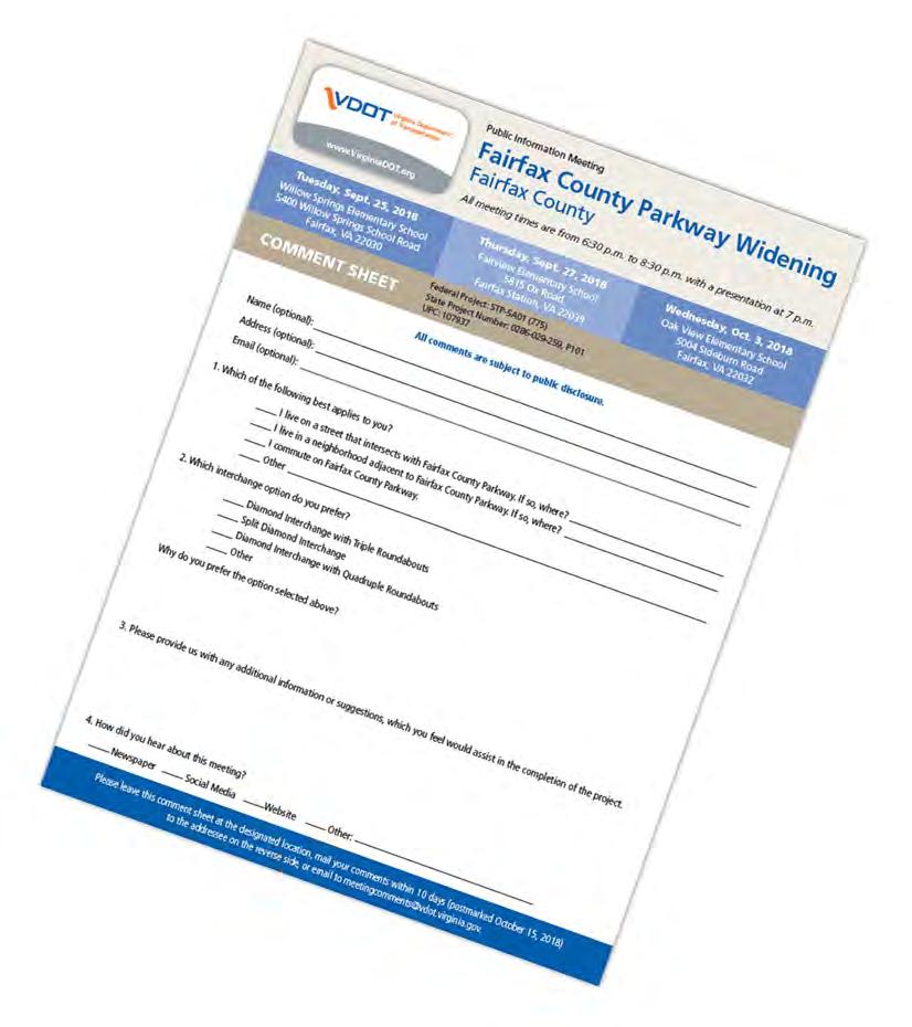
1 Get Involved VDOT representatives will review and evaluate information received as a result of this meeting. Please fill out the comment sheet provided in this brochure if you have any comments or questions. You may leave the sheet or any other written comments in the comment box, or mail/ your comments. Comments must be postmarked, ed or delivered to VDOT by Oct. 15, Contact Information Primary Contact: Sitaram Kodali, P.E. sitaram.kodali@vdot.virginia.gov Andrew Beacher, P.E. andrew.beacher@vdot.virginia.gov Location & Design Preliminary Engineering Mail comments to Mr. Sitaram Kodali at the address below or meetingcomments@vdot.virginia.gov. Please reference Fairfax County Parkway Widening in the subject line. Project information shared at this meeting will be available online at and at VDOT s Northern Virginia Office Alliance Drive Fairfax, VA Alliance Drive Fairfax, VA Tuesday, Sept. 25, 2018 Willow Springs Elementary School 5400 Willow Springs School Road Fairfax, VA Public Information Meeting Welcome to the Virginia Department of Transportation s (VDOT) Public Information Meeting on proposed improvements to the Fairfax County Parkway (Route 286). The project will also include an interchange that will consolidate Popes Head Road and the future Shirley Gate Road extension, improvements to the existing trail in the Fairfax County right of way, and construction of a new shared-use path to make the trail continuous within the project limits. We look forward to your active participation. This public information meeting is being held to provide an opportunity for citizens and Project Overview Public Information Meeting Fairfax County Parkway Widening Fairfax County All meeting times are from 6:30 p.m. to 8:30 p.m., presentation starts at 7 p.m. Thursday, Sept. 27, 2018 Fairview Elementary School 5815 Ox Road Fairfax Station, VA Wednesday, Oct. 3, 2018 Oak View Elementary School 5004 Sideburn Road Fairfax, VA organizations to give VDOT comments and/or suggestions on the proposed project. VDOT strives to ensure that all members of the community have the opportunity to participate in public decisions on transportation projects and programs affecting them. VDOT representatives are present to discuss the project and answer your questions. A comment sheet is included in this brochure and your input is encouraged. All written comments received on this project will be reviewed by the design team. Brian Costello brian.costello@vdot.virginia.gov Right of Way & Utilities 4975 Alliance Drive Fairfax, VA Purpose: Aims to relieve congestion and improve safety Jennifer McCord jennifer.mccord@vdot.virginia.gov Communications 4975 Alliance Drive Fairfax, VA Project Length: About 5 miles from Ox Road (Route 123) to TTY/TDD Dial 711 just north of Lee Highway (Route 29) 2018 Commonwealth of Virginia Improvements: Widen the Fairfax County Parkway from four to six lanes from Route 29 to Route 123, build an interchange at Popes Head Road and the future Shirley Gate Road Extension, reconfigure intersections along project limits, improvements to the existing trail in the Fairfax County right of way, and build a new shared-use path to make the trail continuous within the project limits State Project: , P101, UPC: , Federal: STP-5A01 (775)
.")


2 Project Description This project aims to reduce congestion and improve safety by widening the Fairfax County Parkway (Route 286) from four to six lanes between Route 29 (Lee Highway) and Route 123 (Ox Road). The project will also include an interchange that will consolidate Popes Head Road and the future Shirley Gate Road extension, improvements to the existing trail in the Fairfax County Parkway right of way and build a new shared-use path to make the trail continuous within the project limits. This project will be implemented as part of a phased approach based on funding availability. Phase 1: Popes Head Road and Shirley Gate Road Interchange Phase 2: Fairfax County Parkway Widening Tonight s meeting is being held to obtain feedback from the community about preliminary design options. Popes Head Road / Shirley Gate Road Extension Interchange Alternative Options Option 1/1A: Triple Roundabouts Direct access to Shirley Gate Road Extension with connections to realigned Popes Head Road Option 1A has additional ramps (highlighted in pink) Build two bridges over Fairfax County Parkway Estimated Project Cost Engineering Design: $14 million Right of Way Acquisition/Utility Relocation: $32 million Construction: Phase 1: $54.6 million Phase 2: $94 million Total Cost: $194.6 million These project costs are estimates and subject to change as the project design is further developed. The project is being financed with federal, state and local funds, including Smart Scale and Northern Virginia Transportation Authority funding. Civil Rights VDOT ensures nondiscrimination and equal employment in all programs and activities in accordance with Title VI and Title VII of the Civil Rights Act of If you need more information or special assistance for persons with disabilities or limited English proficiency, contact Mr. Sitaram Kodali at or TTY/TDD 711. Anticipated Schedule Public Information Meetings Sept. 25, Sept. 27 and Oct. 3, 2018 Comment Period Ends Oct. 15, 2018 Public Hearing Late 2018/Early 2019 Design Approval Mid 2019 Depending on the delivery method, Phase 1 construction could begin as early as late Phase 2 construction will be determined as additional funding becomes available. Option 2: Split Diamond Interchange Direct access to Popes Head Road and Shirley Gate Road Extension Similar to existing interchange at Fair Lakes Parkway and Monument Drive Option 2A/2D: Quadruple Roundabouts Direct access to realigned Popes Head Road and Shirley Gate Road Extension Option 2D has additional ramps (highlighted in pink) Build two bridges over Fairfax County Parkway Right of Way Preliminary right of way impacts presented on the displays are conceptual in nature and may change as the design is refined. The property owners will be informed of the exact location of the easements during the right of way acquisition process and prior to construction. Information about right of way purchase is discussed in VDOT s brochure, Right of Way and Utilities: Guide for Property Owners and Tenants. Copies of this brochure are available here from VDOT personnel. After this meeting, information regarding right of way may be obtained from the right of way contact listed on the back of this brochure. Environmental Review In cooperation with the Federal Highway Administration (FHWA) and in accordance with the National Environmental Policy Act (NEPA) and 23 CFR 771, VDOT will be initiating an environmental study to evaluate potential impacts from the project to socio-economic, natural and historic resources, including potential traffic noise impacts. VDOT will coordinate the appropriate federal, state and local agencies as part of the environmental review and approval process required during project design.

3 Public Information Meeting Fairfax County Parkway Widening Fairfax County All meeting times are from 6:30 p.m. to 8:30 p.m. Presentation starts at 7 p.m. Tuesday, Sept. 25, 2018 Willow Springs Elementary School 5400 Willow Springs School Road Fairfax, VA Thursday, Sept. 27, 2018 Fairview Elementary School 5815 Ox Road Fairfax Station, VA Wednesday, Oct. 3, 2018 Oak View Elementary School 5004 Sideburn Road Fairfax, VA COMMENT SHEET Federal Project: STP-5A01 (775), State Project Number: , P101, UPC: All comments are subject to public disclosure. Name (optional): Address (optional): (optional): 1. Which of the following best applies to you? I live on a street that intersects with Fairfax County Parkway. If so, where? I live in a neighborhood adjacent to Fairfax County Parkway. If so, where? I commute on Fairfax County Parkway. Other 2. Which interchange option do you prefer? Why do you prefer the option selected? Option 1: Triple Roundabouts Option 1A: Triple Roundabouts with Additional Ramps Option 2: Split Diamond Interchange Option 2A: Quadruple Roundabouts Option 2D: Quadruple Roundabouts with Additional Ramps Other 3. Please provide us with any additional information or suggestions that will assist in the completion of the project. 4. How did you hear about this meeting? Newspaper Social Media Website Other: Please leave this comment sheet at the designated location, mail your comments (postmarked October 15, 2018) to the addressee on the reverse side, or to meetingcomments@vdot.virginia.gov. Please include Fairfax County Parkway Widening in the subject line.
4 Fold Line Postal Service will not deliver without a stamp Virginia Department Of Transportation Northern Virginia District Sitaram Kodali, P.E Alliance Drive Fairfax, VA Fold Line
5
 to Route 123 (Ox Road) State Project No.")

6 Fairfax County Parkway (Route 286) Widening Project Route 29 (Lee Highway) to Route 123 (Ox Road) State Project No , P101; UPC September 25 th, 27 th, and October 3 rd, :30 to 8:30 PM Public Information Meetings
7 Purpose of Tonight s Meeting Inform you of where we are in the project process and follow-up of community meetings Inform you of updated concepts developed for the proposed interchange with Popes Head Road/Shirley Gate Road Extension and other improvements along the corridor Discuss preliminary noise analysis findings Answer questions and hear your concerns Nick Roper, VDOT District Engineer for Project Development Andy Beacher, VDOT, Project Sponsor John Maddox, WRA, Design Consultant Alex Nies, MT, Noise Consultant Sitaram Kodali, VDOT, Design Project Manager


8 Project Objectives Reduce recurring congestion along the corridor Provide access to future Patriot Park development and the future extension of Shirley Gate Road Improve safety at crash hot-spots Provide multimodal accommodations for pedestrians and bicyclists Grass Median Median Barrier
9 Project Overview Widening Fairfax County Parkway (FCP) to provide third lane in each direction Improvements to intersections within project limits Interchange at Popes Head Road Includes access to future FCPA entrance at Patriot Park and the future extension of Shirley Gate Road Upgrades to shared use path Other Design Considerations Environmental: NEPA document, noise analysis Right-of-way impacts

10 Public Outreach
")
11 Route 123 (Ox Road) Interchange


12 Route 123 Interchange Traffic Operations Travel times compared along southbound Fairfax County Parkway from Burke Centre Parkway to southbound Route 123 at Chapel Road Key Findings 2046 Build condition travel times are similar to existing conditions Significant benefits with added turn/thru lanes SB FCP at Burke Centre Pkwy to SB Route 123 at Chapel Rd Minutes min 3.6 min 4.0 min Existing 2046 No Build 2046 Build


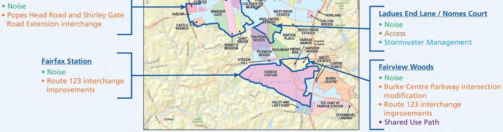
13 Burke Centre Parkway Intersection Right-In/Right-Out Eliminates existing traffic signal Prohibits all left turn and U-turn movements at Burke Centre Parkway Requires grade separation of pedestrian crossing of Fairfax County Parkway
 at")
 track crossing underneath FCP New shared use path along east side of FCP and crosses Burke Centre Parkway")

14 Shared Use Path Crossing Project Team is currently evaluating 3 options: Option A: Pedestrian Bridge Option B: Railroad Underpass Option C: Fairfax Station Underpass Construct new pedestrian bridge spanning Fairfax County Parkway (FCP) at Burke Centre Parkway At grade crossing required at Fairview Woods Drive Shared use path adjacent to Norfolk Southern Railroad (NSRR) track crossing underneath FCP New shared use path along east side of FCP and crosses Burke Centre Parkway at grade Requires approval and easements from NSRR Shared use path adjacent to Fairfax Station Road crossing underneath FCP New shared use path along east side of FCP and crosses Burke Centre Parkway at grade Requires widening of Fairfax Station/NSRR bridge
")


15 Ladues End Lane and Nomes Court Intersection Left-In with Restricted Crossing U-Turn (RCUT) Removes left turning movement exiting from Ladues End Lane and Nomes Court Current Ladues End Lane left out movement must turn right and use RCUT or Route 123 interchange to travel north Current Nomes Court left out movement must turn right and use the Popes Head Road interchange to travel south

 Option 1")

16 Popes Head Road and Shirley Gate Road Extension Preliminary Interchange Options (April 2018) Option 1 Triple Roundabouts Option 2 Split Diamond Option 2A Quadruple Roundabouts
17 Popes Head Road and Shirley Gate Extension Interchange Option 1A: Triple Roundabouts with Additional Ramps Direct access from FCP to Popes Head Road and Shirley Gate Road Extension Popes Head Road and Shirley Gate Extension bridges spanning existing Fairfax County Parkway Estimated Construction Cost = $61M

18 Popes Head Road and Shirley Gate Extension Interchange Option 2: Split Diamond Direct access from FCP to Popes Head Road and Shirley Gate Road Extension Fairfax County Parkway to be below existing grade; access ramps and crossovers to match existing grade Estimated Construction Cost = $69M
19 Popes Head Road and Shirley Gate Extension Interchange Option 2D: Quadruple Roundabouts with Additional Ramps Direct access from FCP to Popes Head Road and Shirley Gate Road Extension Popes Head Road and Shirley Gate Extension bridges spanning existing Fairfax County Parkway Estimated Construction Cost = $67M
20 Popes Head Road and Shirley Gate Extension Interchange Options Comparison Criteria Option 1A: Triple Roundabouts Option 2: Split Diamond Option 2D: Quadruple Roundabouts Provides Direct Access between Fairfax County Parkway and Popes Head Road/Shirley Gate Extension Intersection Level of Service (LOS) and delays Constructability/Maintenance of Traffic Safety Improvements Bike and Pedestrian Accommodations Environmental/Patriot Park Impacts Increase in traffic noise levels Right of Way Impacts Estimated Construction Cost $61M* $69M* $67M* Legend Excellent Favorable Fair Unfavorable Poor *$54.6M in funding available for construction (includes $4M for design) **Design revisions will be investigated for each option
21 Interchange Option 1 and Option 1A Comparison Option 1 Estimated Construction Cost: $53 Million Option 1A Estimated Construction Cost: $61 Million Based on public input, features added in Option 1A: Ramp northbound Fairfax County Parkway to eastbound Popes Head Road Ramp westbound Popes Head Road to northbound Fairfax County Parkway Ramp eastbound Popes Head Road to southbound Fairfax County Parkway

22 Interchange Option 2A and Option 2D Comparison Option 2A Estimated Construction Cost: $58 Million Option 2D Estimated Construction Cost: $67 Million Additional features included in Option 2D: Direct ramp from Popes Head Road to northbound Fairfax County Parkway Direct ramp from westbound Shirley Gate Extension to southbound Fairfax County Parkway


23 Popes Head Road Interchange Traffic Operations Key Findings All five options have acceptable operating conditions Existing: Popes Head Road motorists have delays of up to 10 minutes to enter FCP (AM peak) 2046 Design Year: 2-3 minutes maximum to travel through the interchange No single option is preferred based on traffic operations Option 1 Option 1A Option 2 Option 2A Option 2D


24 Improvements to Northern Section Widening ties into existing 6- lane roadway section north of Route 29 Interchange Grass median south of Route 29 interchange; concrete median barrier from south of Route 29 interchange north Shared Use Path upgrades on east side of Fairfax County Parkway
25 Fairfax County Parkway Travel Times 2046 No Build Conditions No improvements along Fairfax County Parkway Southbound travel times are minutes greater than existing conditions 2046 Build Conditions Includes: Fairfax County Parkway widening Popes Head Road interchange Burke Centre Parkway signal removal Northbound AM Peak 15 minute travel time savings Southbound PM Peak 18 minute travel time savings mph travel speeds Minutes Minutes Fairfax County Parkway South of Route 123 to US 29 AM Peak Hour 16.0 Northbound Southbound Northbound Southbound Northbound Southbound Existing 2046 No Build 2046 Build Fairfax County Parkway South of Route 123 to US 29 PM Peak Hour Southbound Southbound Northbound Northbound Northbound Southbound Existing 2046 No Build 2046 Build


26 Preliminary Noise Analysis Summary Slide Total of 4 new noise barriers considered feasible and reasonable One existing barrier replacement on the west side of Fairfax County Parkway between Route 123 and Clara Barton Drive considered feasible and reasonable Noise Analysis Process


27 Draft Preliminary Noise Analysis Fairfax County Parkway at Route 123 Interchange

28 Draft Preliminary Noise Analysis Fairfax County Parkway at Burke Centre Parkway

29 Draft Preliminary Noise Analysis Fairfax County Parkway at Ladues End Lane and Nomes Court


30 Draft Preliminary Noise Analysis Fairfax County Parkway at Popes Head Road and Shirley Gate Extension Interchange

31 Draft Preliminary Noise Analysis Fairfax County Parkway at Braddock Road Interchange

32 Draft Preliminary Noise Analysis Fairfax County Parkway at Route 29 Interchange
33 Project Schedule: Milestones Dates Public Information Meeting December 7, 2017 Begin Noise Study January 2018 Public Outreach Meetings January April 2018 Draft Preliminary Noise Study Completion Mid 2018 Public Information Meetings September October 2018 Public Hearing Late 2018/Early 2019 Design Approval Mid 2019 Phase 1 Construction Popes Head Road/Shirley Gate Road Interchange o Award Design Build Contract/Begin Construction o Completion of Construction Late 2019 Late 2022 Phase 2 Construction Fairfax County Parkway Widening To be determined as additional funding becomes available
34 Estimated Project Cost and Funding Project Estimate and Budget Project Popes Head Interchange and FCP Widening Current Funding Awarded Preliminary Engineering These project costs are estimates and subject to change as the project design is further developed. Project Amount Source Date Awarded Phase Phase 1: Popes Head Interchange $4M Fairfax County FY2016 Construction Phase 1: Popes Head Interchange $50.6M Smart Scale FY2018 Construction Phase 2: FCP Widening $25.5M NVTA & RSTP 7/14/2016 Right of Way & Design Popes Head Interchange and FCP Widening $67M NVTA 6/14/2018 Construction Total: Right of Way/ Utility Relocation $147.1M Construction Subtotal Total Phase 1: $9.7M Phase 1: $54.6M $64.3M Smart Scale Budget Phase 2: $14M Phase 2: $22.3M Phase 2: $94M $116.3M $194.6M
35 Summary Recommended Design Features Route 123 improvements Widening with grass median from Route 123 to Route 29 Burke Centre Parkway intersection Ladues End Lane and Nomes Court intersection Widening with concrete median barrier through Route 29 interchange Shared use path location Further Design Required Final configuration of interchange Shared use path crossing Final noise analysis
36 Questions? Contact Information Comments to: Please include Fairfax County Parkway Widening in the subject line Project information for this meeting is available online at: VDOT s Northern Virginia Office

37 Comments and Questions?
Project Overview. Rolling Road Widening Fairfax County. Get Involved. Design Public Hearing. Contact Information
 Get Involved VDOT representatives will review and evaluate information received as a result of this meeting. Please fill out the comment sheet provided in this brochure if you have any comments or questions.
Public Information Meeting
 Richmond Highway (U.S. Route 1) Corridor Improvements Public Information Meeting Tuesday, April 18, 2017 Mount Vernon High School 8515 Old Mt. Vernon Road, Alexandria, VA 22309 Amanda Baxter, VDOT, Special
County of Fairfax, Virginia. Department of Transportation
 Fairfax County Parkway History 2 Planning began 50 years ago 1960s Washington s Regional Transportation Plan Recommends improved north/south travel Construct Capital Beltway and outer beltway Outer beltway
Meeting Schedule 7:00-7:15 Open House 7:15-7:45 Existing Conditions/Short-Term Improvements Study Presentation 7:45-8:00 Q&A Session 8:00-8:10
 Meeting Schedule 7:00-7:15 Open House 7:15-7:45 Existing Conditions/Short-Term Improvements Study Presentation 7:45-8:00 Q&A Session 8:00-8:10 Long-Term Study Presentation 8:10-8:40 Table Discussions 8:40-9:00
Route 7 (East Market Street) Interchange at Battlefield Parkway Town of Leesburg Project No: UPC Presentation to Town Council
 Interchange at Battlefield Parkway Town of Leesburg Project No: UPC Presentation to Town Council") Route 7 (East Market Street) Interchange at Battlefield Parkway Town of Leesburg Project No: 0007-253-109 UPC 106573 Presentation to Town Council June 26, 2017 Council Decisions East Market Street / Battlefield
Route 7 (East Market Street) Interchange at Battlefield Parkway Town of Leesburg Project No: 0007-253-109 UPC 106573 Presentation to Town Council June 26, 2017 Council Decisions East Market Street / Battlefield
I-395 Express Lanes Northern Extension Project Public Hearings
 I-395 Express Lanes Northern Extension Project Public Hearings Susan Shaw, PE, Megaprojects Director Virginia Department of Transportation Amanda Baxter, Special Projects Manager Virginia Department of
NORTHERN VIRGINIA HIGHLIGHTS for the Dulles Area Transportation Association
 NORTHERN VIRGINIA HIGHLIGHTS for the Dulles Area Transportation Association June 20, 2012 Garrett Moore VDOT District Administrator, Northern Virginia Paving Program 2012 This season's paving program will
I-395 Express Lanes Northern Extension Project Crystal City Civic Association September 21, 2016
 I-395 Express Lanes Northern Extension Project Crystal City Civic Association September 21, 2016 Mike Snare, PE, Project Manager Virginia Department of Transportation GEC Michelle Holland, Megaprojects
Giles Run Connector Road
 Giles Run Connector Road Laurel Hill Adaptive Reuse Area to Laurel Crest Drive South County Federation Meeting June 14, 2016 History Connector road included in the Laurel Hill Comprehensive Plan amendment
Project Description Form 6V
 Project Description Form 6V Basic Project Information Submitting Jurisdiction/Agency: Prince William County Project Title: Route 15 Widening: Route 55 to south of RR tracks & Construct RR Overpass Project
PROPOSED BICYCLE AND PEDESTRIAN FACILITY Vicinity of Route 123/I-495 Interchange Tysons, Fairfax County, Virginia
 PROPOSED BICYCLE AND PEDESTRIAN FACILITY Vicinity of Route 123/I-495 Interchange Tysons, Fairfax County, Virginia PRELIMINARY ENGINEERING REPORT Prepared for: Prepared by: July 2017 Table of Contents 1
Route 245 over Broad Run. The recently replaced bridge links The Plains and other communities in northern Fauquier to Interstate 66.
 28 VIRGINIA DEPARTMENT OF TRANSPORTATION \\ CULPEPER DISTRICT Route 245 over Broad Run. The recently replaced bridge links The Plains and other communities in northern Fauquier to Interstate 66. PROJECT
Los Altos Hills Town Council - June 18, 2015 Palo Alto City Council June 22, AGENDA ITEM #2.B Presentation
 Los Altos Hills Town Council - June 18, 2015 Palo Alto City Council June 22, 2015 AGENDA ITEM #2.B Presentation Previous Presentations Los Altos Hills Town Council in May 2014 and February 2015 Palo Alto
City of Fairfax, Virginia City Council Work Session
 City of Fairfax, Virginia City Council Work Session Agenda Item # City Council Meeting 12a 9/8/2015 TO: FROM: SUBJECT: ISSUE(S): SUMMARY: FISCAL IMPACT: RECOMMENDATION: ALTERNATIVE COURSE OF ACTION: RESPONSIBLE
I-395 Express Lanes Northern Extension Project Fairlington Citizens Association September 12, 2016
 I-395 Express Lanes Northern Extension Project Fairlington Citizens Association September 12, 2016 Susan Shaw, PE, Megaprojects Director, Virginia Department of Transportation Amanda Baxter, Special Projects
Route 29 Solutions Projects
 Route 29 Solutions Route 29 Solutions Projects www.route29solutions.org October 10, 2014 Route 29 Widening to Six Lanes Albemarle County This project will widen a 1.8-mile segment of Route 29 from four
Washington DC Section of ITE Project Briefing
 Washington DC Section of ITE Project Briefing November 5, 2015 Renée Hamilton, VDOT, Deputy District Administrator I-66 Outside the Beltway Improvement Area Project Location Virginia 2 Purpose and Need
DULLES AREA TRANSPORTATION ASSOCIATION (DATA) February 18, Susan Shaw, P.E., VDOT, Megaprojects Director
 February 18, Susan Shaw, P.E., VDOT, Megaprojects Director") DULLES AREA TRANSPORTATION ASSOCIATION (DATA) February 18, 2015 Susan Shaw, P.E., VDOT, Megaprojects Director I-66 Corridor Conditions Steady population growth Employment growth in activity centers Congestion
DULLES AREA TRANSPORTATION ASSOCIATION (DATA) February 18, 2015 Susan Shaw, P.E., VDOT, Megaprojects Director I-66 Corridor Conditions Steady population growth Employment growth in activity centers Congestion
Institute for Real Estate Management Chapter (IREM) 77 VDOT Northern Virginia Megaprojects September 13, 2017
 77 VDOT Northern Virginia Megaprojects September 13, 2017") Institute for Real Estate Management Chapter (IREM) 77 VDOT Northern Virginia Megaprojects September 13, 2017 Susan Shaw, P.E., Megaprojects Director Virginia Department of Transportation Northern Virginia
Institute for Real Estate Management Chapter (IREM) 77 VDOT Northern Virginia Megaprojects September 13, 2017 Susan Shaw, P.E., Megaprojects Director Virginia Department of Transportation Northern Virginia
Project Description Form 8EE
 Project Description Form 8EE Basic Project Information Submitting Jurisdiction/Agency: Town of Dumfries Project Title: Route 1 (Fraley Blvd) Widening: Brady's Hill Road to Dumfries Road Project Location:
Fairfax Alliance for Better Bicycling. Susan Shaw, P.E., Megaprojects Director Virginia Department of Transportation
 Fairfax Alliance for Better Bicycling February 28, 2019 Susan Shaw, P.E., Megaprojects Director Virginia Department of Transportation Nancy Smith, Public Relations Manager FAM Construction Chris Wells,
I-95 Express Lanes Fredericksburg Extension (Fred Ex) Public Hearing. September 25, 2017
 Public Hearing. September 25, 2017") I-95 Express Lanes Fredericksburg Extension (Fred Ex) Public Hearing September 25, 2017 Purpose of Tonight s Meeting Provide information and gain public input: Draft Environmental Assessment (EA) Design
I-95 Express Lanes Fredericksburg Extension (Fred Ex) Public Hearing September 25, 2017 Purpose of Tonight s Meeting Provide information and gain public input: Draft Environmental Assessment (EA) Design
Supervisor Cook Announces Final Plans for Braddock Road Improvement Project
 Supervisor Cook Announces Final Plans for Braddock Road Improvement Project After more than two years of study and significant community input, I am pleased to announce the final plans for the Braddock
I-20 ODESSA-MIDLAND CORRIDOR STUDY. Public Meeting for Schematic Design
 I-20 ODESSA-MIDLAND CORRIDOR STUDY Public Meeting for Schematic Design The environmental review, consultation, and other actions required by applicable Federal environmental laws for this project are being,
Environmental Assessment Findings & Recommendations. Public Hearing November 13, 2014
 Environmental Assessment Findings & Recommendations Public Hearing November 13, 2014 Welcome! Welcome and Introductions Project and Environmental Assessment Overview Public Comments Adjourn Purpose of
EXHIBIT B-1 PROJECT DESCRIPTION. Phase 1 of the Preferred Alternative
 EXHIBIT B-1 PROJECT DESCRIPTION Phase 1 of the Preferred Alternative The Transform 66 Public-Private Partnership (P3) Project (the Project ) means the Phase 1 of the Preferred Alternative components of
Highway 49, Highway 351 and Highway 91 Improvements Feasibility Study Craighead County
 Highway 49, Highway 351 and Highway 91 Improvements Feasibility Study Craighead County Executive Summary March 2015 Highway 49, Highway 351 and Highway 91 Improvements Feasibility Study Craighead County
CHAPTER 3 STUDY AREA OPERATIONAL OVERVIEW
 HPTER 3 STUY RE OPERTIONL OVERVIEW This chapter describes the overall traffic operations within the study area under existing and future conditions and focuses on individual intersections not directly
METHODOLOGY. Signalized Intersection Average Control Delay (sec/veh)
") Chapter 5 Traffic Analysis 5.1 SUMMARY US /West 6 th Street assumes a unique role in the Lawrence Douglas County transportation system. This principal arterial street currently conveys commuter traffic
Chapter 5 Traffic Analysis 5.1 SUMMARY US /West 6 th Street assumes a unique role in the Lawrence Douglas County transportation system. This principal arterial street currently conveys commuter traffic
Welcome. Thank you for your interest in the Lewis & Clark Viaduct Concept Study
 Welcome Thank you for your interest in the Lewis & Clark Viaduct Concept Study Please use the arrows in the upper left hand corner to navigate through the presentation. Use the envelope icon to ask a question
WELCOME. Stakeholder Involvement Group Meeting #2 Round Lake Public Works October 24, 2018
 WELCOME Stakeholder Involvement Group Meeting #2 Round Lake Public Works October 24, 2018 MEETING AGENDA 1. Welcome and Introductions 2. Study Progress Update 3. Problem Statement 4. Technical Analysis
Transform 66 Project February 4, 2016 Partnering Conference Michigan Department of Transportation American Council of Engineering Companies
 Transform 66 Project February 4, 2016 Partnering Conference Michigan Department of Transportation American Council of Engineering Companies Susan Shaw, PE, CCM, DBIA Megaprojects Director Northern Virginia
Legislative Update Williamsburg Residency
 Hampton Roads District Legislative Update Williamsburg Residency Jim Brewer, Resident Administrator 757-253-5140 Projects Under Way Warwick Boulevard Project http://www.warwickboulevard.org/ Contractors:
I-395 Express Lanes Northern Extension Project Arlington County Board October 18, 2016
 I-395 Express Lanes Northern Extension Project Arlington County Board October 18, 2016 Susan Shaw, PE, Megaprojects Director Virginia Department of Transportation Amanda Baxter, Special Projects Manager
FY STATEWIDE TRANSPORTATION IMPROVEMENT PROGRAM New Jersey Department of Transportation Projects
 ROUTE/ Project ID No. TIP No. Electrical Load Center Replacement - North 04324 04324 This project will provide for the betterment of the existing highway lighting facilities located along Routes 3, 17
Municipal Class EA To Address Traffic Congestion On The Ontario Street Corridor (Grand Bend) Public Information Meeting June 4, 2018
 Public Information Meeting June 4, 2018") Municipal Class EA To Address Traffic Congestion On The Ontario Street Corridor (Grand Bend) Public Information Meeting June 4, 2018 Background Agenda Traffic Study Update Class EA Alternatives Bridge
Municipal Class EA To Address Traffic Congestion On The Ontario Street Corridor (Grand Bend) Public Information Meeting June 4, 2018 Background Agenda Traffic Study Update Class EA Alternatives Bridge
Access Management Regulations and Standards
 Access Management Regulations and Standards Efficient highway operation Reasonable property access Concept of Access Management The way to manage access to land development while simultaneously preserving
VDOT I-66 Inside the Beltway Eastbound Widening Environmental Assessment. Staff Recommendations
 VDOT I-66 Inside the Beltway Eastbound Widening Environmental Assessment Staff Recommendations Department of Environmental Services Transportation January 28, 2017 Timeline of Transform66 June 2012: I-66
Project Mobility - Route 3 South Express Toll Lanes. Industry Day Overview
 Project Mobility - Route 3 South Express Toll Lanes Industry Day Overview October 15, 2014 Today s Agenda Project Mobility Overview Design Alternatives and Construction Estimates Existing Traffic Congestion/Project
I-264 CORRIDOR EVALUATION STUDY. September 7, 2016 Eric Stringfield VDOT Planning Director Chris Lawrence AECOM Senior Transportation Engineer
 I-264 CORRIDOR EVALUATION STUDY September 7, 2016 Eric Stringfield VDOT Planning Director Chris Lawrence AECOM Senior Transportation Engineer Study Overview Interchange Locations Study Context Follow-up
Terwillegar Drive Expressway Draft Concept Plan
 Terwillegar Drive Expressway Draft Concept Plan Anthony Henday Drive to Whitemud Drive November 28 5:00-8:00 p.m. December 1 10:00 a.m. - 3:00 p.m. Let s Talk Today you can: Learn about the new direction
Dulles Area Transportation Association. October 11, Susan Shaw, P.E., Megaprojects Director Virginia Department of Transportation
 Dulles Area Transportation Association October 11, 2017 Susan Shaw, P.E., Megaprojects Director Virginia Department of Transportation Transform 66: Outside the Beltway 2 Project Overview Multimodal improvements
DEPARTMENT OF ENVIRONMENTAL SERVICES. North Harrison Street (Lee Highway to Little Falls Road) Comparative Analysis. Prepared for:
 Comparative Analysis. Prepared for:") DEPARTMENT OF ENVIRONMENTAL SERVICES North Harrison Street (Lee Highway to Little Falls Road) Comparative Analysis Prepared for: Arlington County Department of Environmental Services 2100 Clarendon Boulevard,
DEPARTMENT OF ENVIRONMENTAL SERVICES North Harrison Street (Lee Highway to Little Falls Road) Comparative Analysis Prepared for: Arlington County Department of Environmental Services 2100 Clarendon Boulevard,
Application of a Complete Street
 Application of a Complete Street Southbend to Prima Vista Update May 14, 2018 Meeting Agenda Perspective and History Public input received Typical sections being considered Presentation of the 2-lane master
WHANGAREI IMPROVEMENTS
 WHANGAREI IMPROVEMENTS PROJECT OVERVIEW The NZ Transport Agency (NZTA) is working with Whangarei District Council (WDC) to improve the state highway through Whangarei. In addition to the recently completed
I-95/Temple Avenue Improvements Project Colonial Heights, VA
 I-95/Temple Avenue Improvements Project Colonial Heights, VA Pardon Our Dust Informational Meeting February 3, 2016 Harold Dyson, P.E. Construction Manager, Richmond District Tom Heil, P.E. Allan Myers
Thank you for attending
 Improving mobility safety comfort WELCOME Thank you for attending The purpose of this meeting is to: Learn about the project Prioritize potential walking and biking improvements on Snelling Ave Gather
Attached for your reference please find project updates on ongoing VDOT construction projects in Southampton County.
 SOUTHAMPTON COUNTY BOARD OF SUPERVISORS Regular Session i July 25, 2016 6. HIGHWAY MATTERS A. PLAN PROJECT UPDATES Attached for your reference please find project updates on ongoing VDOT construction projects
City of Madison, East Johnson Street North Baldwin Street to First Street Local Street Dane County
 City of Madison, East Johnson Street North Baldwin Street to First Street Local Street Dane County Public Involvement Meeting Thursday, April 28, 2016 6 to 8 P.M. Lapham Elementary School 1045 E. Dayton
Access Management Regulations and Standards
 Access Management Regulations and Standards January 2014 Efficient highway operation Reasonable property access Concept of Access Management The way to manage access to land development while preserving
UPC Design / CN Locally Administered PE Phase VDOT Administered CN Phase
 Presentation for County Board, February 27, 2018 Regular Hearing N. Lynn Street Esplanade and Custis Trail Improvements Funding Request for VDOT Construction Bid Award UPC Design 70762 / CN 109813 Locally
WISCONSIN AVENUE EXTENSION SECOND PUBLIC INFORMATION MEETING. March 28, 2017
 WISCONSIN AVENUE EXTENSION SECOND PUBLIC INFORMATION MEETING March 28, 2017 STUDY AREA N MEETING AGENDA Introductions Study Background Alternatives Studied Recommended Alternative Discussion STUDY BACKGROUND
City of Fairfax, Virginia City Council Work Session
 City of Fairfax, Virginia City Council Work Session Agenda Item # 4c City Council Meeting 6/2/2015 TO: FROM: SUBJECT: Honorable Mayor and Members of City Council Robert Sisson, City Manager Discussion
FI-2 I-66 Between Route 29, Lee Highway and Route 15, James Madison Highway
 TRANSPORTATION PLAN INTENT Transportation is the key to the economic and social development of Prince William County and especially to the I 66/Route 29 Sector Plan area. This includes transportation for
Appendix D: Concept Screening
 Concept Description Concept #1 Route 288 Roadway Widening This concept consists of constructing a third lane on northbound and southbound Route 288 between Powhite Parkway and US 360. This improvement
495 EXPRESS LANES NORTHERN EXTENSION STUDY COMMENT SUMMARY REPORT JUNE 11, 2018 PUBLIC INFORMATION MEETING
 495 EXPRESS LANES NORTHERN EXTENSION STUDY COMMENT SUMMARY REPORT JUNE 11, 2018 PUBLIC INFORMATION MEETING Federal: NHPP-0495(095), State: 0495-029-419, UPC: 113414 The Virginia Department of Transportation
Offset Single Point Interchange I-25 at Rio Bravo Boulevard Albuquerque, New Mexico
 Offset Single Point Interchange I-25 at Rio Bravo Boulevard Albuquerque, New Mexico INSTITUTE OF TRANSPORTATION ENGINEERS 2016 WESTERN DISTRICT MEETING JULY 11, 2016 7/11/2016 1 Project Vicinity Map 7/11/2016
Northwest Corridor Project Interchange Modification, Interchange Justification and System Analysis Report Reassessment (Phase I)
") Northwest Corridor Project Interchange Modification, Interchange Justification and System Analysis Report Reassessment (Phase I) Introduction The Georgia Department of Transportation (GDOT) prepared a
Northwest Corridor Project Interchange Modification, Interchange Justification and System Analysis Report Reassessment (Phase I) Introduction The Georgia Department of Transportation (GDOT) prepared a
Golden s Plan. For the Highway 6 & 93 Corridor
 Golden s Plan For the Highway 6 & 93 Corridor Purpose of the Study Accommodate regional traffic needs on Highways 6 and 93, as defined by the Northwest Quadrant Feasibility Study. Find a solution that
City of Madison, East Johnson Street North Baldwin Street to First Street Local Street Dane County
 City of Madison, East Johnson Street North Baldwin Street to First Street Local Street Dane County Public Involvement Meeting Thursday, November 10, 2016 5:30 to 7 P.M. Festival Foods 810 E. Washington
INTERSTATE 395 EXPRESS LANES NORTHERN EXTENSION ALTERNATIVES ANALYSIS TECHNICAL REPORT SEPTEMBER 2016
 INTERSTATE 395 EXPRESS LANES NORTHERN EXTENSION ALTERNATIVES ANALYSIS TECHNICAL REPORT SEPTEMBER 2016 INTERSTATE 395 EXPRESS LANES NORTHERN EXTENSION Alternatives Analysis Technical Report City of Alexandria,
INNOVATIVE INTERSECTION DESIGN
 INNOVATIVE INTERSECTION DESIGN J. Eddie Valtier, P.E. ELP TP&D Director Introduction Why Do We Need To Start Looking For Innovative Intersection Designs? Congestion is worsening and traffic volumes and
I-66 Corridor Improvements Route 15 to I-495. November 2014
 I-66 Corridor Improvements Route 15 to I-495 November 2014 I-66 Corridor: Haymarket to the Beltway = Park and Ride Lots 2 Purpose and Need Improve multimodal mobility along the I-66 corridor by providing
Route 29 Corridor Assessment Update. Development of Possible Solutions
 Route 29 Corridor Assessment Update Development of Possible Solutions Public Workshop #3 October 27, 2016 Purpose of Developing Possible Solutions Recap of where we ve been and timeline for moving forward
Viewing SMART SCALE Application
 Viewing SMART SCALE Application Route 15 Whites Ferry Road to Points of Rock Bridge Project Status: Submitted Organization: Loudoun County Project ID: 3593 Submitted: 08/06/2018 @ 3:18PM by Bob Brown Created:
Foothill Expressway Improvements Between El Monte and San Antonio
 Foothill Expressway Improvements Between El Monte and San Antonio June 29, 2017 - Los Altos Community Meeting Introduction Project Background Agenda Visit Stations: Provide Input and Ask Questions Reconvene:
Chapter 4 Traffic Analysis
 Chapter 4 Traffic Analysis PURPOSE The traffic analysis component of the K-68 Corridor Management Plan incorporates information on the existing transportation network, such as traffic volumes and intersection
I-215 / NEWPORT ROAD INTERCHANGE PROJECT PRESS KIT
 I-215 / NEWPORT ROAD INTERCHANGE PROJECT PRESS KIT March I-215 / NEWPORT ROAD INTERCHANGE PROJECT Fact Sheet Project Overview This project will reconstruct the existing interchange located on Interstate
Shockoe Bottom Preliminary Traffic and Parking Analysis
 Shockoe Bottom Preliminary Traffic and Parking Analysis Richmond, Virginia August 14, 2013 Prepared For City of Richmond Department of Public Works Prepared By 1001 Boulders Pkwy Suite 300, Richmond, VA
PROJECT OBJECTIVES. Improve vehicle capacity for the intersection. Improve pedestrian and bicycle access
 COMMUNITY MEETING Project Update March 15, 2010 Purcellville, Virginia OVERVIEW Project need / objectives Project recap Design elements Proposed improvements Summary of project benefits / next steps PROJECT
TRANSPORTATION & MOBILITY VISIONING MEETING. August 23 24, 2017
 TRANSPORTATION & MOBILITY VISIONING MEETING August 23 24, 2017 Project Team 1999 South Lakefront Framework Plan In 1999, the Chicago Park District authorized framework plans for three historic parks: Jackson,
4. ENVIRONMENTAL IMPACT ANALYSIS 9. TRANSPORTATION AND TRAFFIC
 4. ENVIRONMENTAL IMPACT ANALYSIS 9. TRANSPORTATION AND TRAFFIC 4.9.1 INTRODUCTION The following section addresses the Proposed Project s impact on transportation and traffic based on the Traffic Study
Transform I-66. Chief Engineer Garrett W. Moore, P.E. July 12, 2018
 Transform I-66 Chief Engineer Garrett W. Moore, P.E. July 12, 2018 Transform 66: Program Goals Improve multimodal mobility by providing diverse travel choices in a cost-effective manner Enhance transportation
Traffic Circulation Study for Neighborhood Southwest of Mockingbird Lane and Airline Road, Highland Park, Texas
 ARIZONA TEXAS NEW MEXICO OKLAHOMA February 13, 2015 Mr. Meran Dadgostar P.E., R.S. Town of Highland Park 4700 Drexel Dr. Highland Park, Texas 75205 Re: Traffic Circulation Study for Neighborhood Southwest
Tysons-Old Meadow Road Bike/Ped Improvements
 Tysons-Old Meadow Road Bike/Ped Improvements Design Workshop #1 Thursday, November 9, 2017, 7:00 pm to 9:00 pm Westgate Elementary School, Falls Church, VA Fairfax County Agenda Open house Presentation
Project Description Form 8AA
 Project Description Form 8AA Basic Project Information Submitting Jurisdiction/Agency: Fairfax County Project Title: Route 1 Widening: Mount Vernon Memorial Highway to Napper Road Project Location: US
City of Gainesville Transportation/Roadway Needs PROJECT SUMMARY
 A1 Roadway Resurfacing $23,846,000 TYPE: Preservation of existing system Roadway resurfacing A2 Signal Replacement $6,000,000 TYPE: Preservation of existing system Replace traffic signals. B1 W 6th St
Welcome to the Quebec Alternatives Analysis Public Meeting
 Welcome to the Public Meeting Please sign in. Public Comment Please fill out a comment card and tell us what you think. Check back or comment any time at: www.quebecalternatives.com Project Area Technical
Joshua Jester, E.I., Florida Department of Transportation, District One
 MEMORANDUM To: From: Joshua Jester, E.I., Florida Department of Transportation, District One Michael Garau, P.E., Kimley-Horn and Associates, Inc. Date: October 5, 2018 Subject: at Gulfstream Avenue Intersection
Truck Climbing Lane Traffic Justification Report
 ROUTE 7 (HARRY BYRD HIGHWAY) WESTBOUND FROM WEST MARKET STREET TO ROUTE 9 (CHARLES TOWN PIKE) Truck Climbing Lane Traffic Justification Report Project No. 6007-053-133, P 101 Ι UPC No. 58599 Prepared by:
Lincoln Avenue Road Diet Trial
 Lincoln Avenue Road Diet Trial Data Collection Report June 1, 2015 Department of Transportation Table of Contents I. Introduction...... 3 II. Data Collection Methodology & Results...... 5 A. Traffic Volume
RM 620 FEASIBILITY STUDY
 RM 620 FEASIBILITY STUDY Sections 5 & 6 December 7, 2015 STUDY PROCESS Study Purpose and Goals The RM 620 Feasibility Study was launched by the Texas Department of Transportation (TxDOT) to analyze transportation
Financial Project ID No(s).: and ETDM No(s).: and 14181
.: and ETDM No(s).: and 14181") Palm Beach Metropolitan Planning Organization (MPO) Presentation I-95 at Boynton Beach Boulevard Interchange and I-95 at Gateway Boulevard Interchange Project Development and Environment Study Palm Beach
Palm Beach Metropolitan Planning Organization (MPO) Presentation I-95 at Boynton Beach Boulevard Interchange and I-95 at Gateway Boulevard Interchange Project Development and Environment Study Palm Beach
Route 28 Corridor Safety and Operations Study Public Information Meetings. July 20 and 22, 2015
 Route 28 Corridor Safety and Operations Study Public Information Meetings July 20 and 22, 2015 1 Study Goals and Objectives Phase 1 Short-term Short-term improvements Ability to implement quickly Cost
Rio Intersection Traffic Restrictions Begin Monday
 May 18, 2016 8 Rio Intersection Traffic Restrictions Begin Monday This special edition of the Route 29 Solutions e mail newsletter includes everything you need to know about the May 23 through September
List of Display Boards
 List of Display Boards Welcome Introduction Municipal Class Environmental Assessment (EA) Process Need and Justification for an Interchange Alternatives for Evaluation Vertical and Horizontal Alignments
State Road 54/56 Tampa Bay s Northern Loop. The Managed Lane Solution Linking I-75 to the Suncoast Parkway
 State Road 54/56 Tampa Bay s Northern Loop The Managed Lane Solution Linking I-75 to the Suncoast Parkway SUNCOAST PARKWAY Both I 75 and the Suncoast Parkway are planning, or in the process of constructing,
Interstate 66 Tier 1 Environmental Impact Statement (EIS)
") WELCOME Welcome to the second Citizen Information Meeting for the Tier 1 Environmental Impact Statement (EIS). As an integral part in the environmental study process, the study team is seeking your comments
WELCOME Welcome to the second Citizen Information Meeting for the Tier 1 Environmental Impact Statement (EIS). As an integral part in the environmental study process, the study team is seeking your comments
Welcome to the Open House
 Leslie Street Between 19 th Avenue and Stouffville Road Addendum to Class Environmental Assessment Study Welcome to the Open House Please sign in at the front desk. March 28, 2017 Richmond Green Sports
7th Street Bridge Project. Public Presentation February 24, :30pm-8pm
 7th Street Bridge Project Public Presentation February 24, 2014 6:30pm-8pm Public Meeting Agenda Welcome and introductions Judith Buethe Opening remarks - David Leamon, PE/Hans Strandgaard, PE Project
Reference number /VP. Lafayette Downtown Congestion Study - Additional Traffic Analysis
 To James Hinkamp and Tony Coe, City of Lafayette Date January 19, 2017 Copies Reference number 243381/VP From Michael Iswalt and Vanessa Peers File reference 4-05 Subject Lafayette Downtown Congestion
Arterial Management Plan for US Route 250 and State Route 623
 Arterial Management Plan for US Route 250 and State Route 623 June 25, 2014 Brad Shelton, AICP Access Management and Traffic Impact Analysis Programs Manager Transportation and Mobility Planning Division
Summary: Mercer County Princeton Avenue & Spruce Street Study January 2009
 Summary: Several recent studies have assessed potential development and redevelopment opportunities in the Mercer Crossing area of Trenton, Ewing, and Lawrence. This Princeton Avenue and Spruce Street
Huntington Station Metro Zone / North Kings Highway Concept Plan
 Summary Narrative of Huntington Station Metro Zone / North Kings Highway Concept Plan Located in Fairfax County, Virginia prepared for A.J. Dwoskin & Associates, Inc.. 9302 Lee Highway, Suite 300 Fairfax,
Route 79/Davol Street Corridor Study
 Route 79/Davol Street Corridor Study Fall River, MA Public Information Meeting #2 November 21, 2013 Fall River Heritage State Park Fall River, MA Agenda Welcome and Introductions Overview of Study Process
72 Avenue Four Laning (BNSF Overpass to 120 Street) WELCOME. Public Information Meeting
 WELCOME. Public Information Meeting") 72 Avenue Four Laning (BNSF Overpass to 120 Street) WELCOME Public Information Meeting Project Goals About the Project The goal of this project is to address congestion along 72 Avenue and adjacent streets
72 Avenue Four Laning (BNSF Overpass to 120 Street) WELCOME Public Information Meeting Project Goals About the Project The goal of this project is to address congestion along 72 Avenue and adjacent streets
MONTGOMERY COUNTY PLANNING DEPARTMENT THE MARYLAND-NATIONAL CAPITAL PARK AND PLANNING COMMISSION
 MONTGOMERY COUNTY PLANNING DEPARTMENT THE MARYLAND-NATIONAL CAPITAL PARK AND PLANNING COMMISSION SHA CTP Project No. MO891A21, US 29, Fairland Road to Musgrove Road Interchange Improvement, Design Review
City of Moorhead Committee of the Whole Meeting
 City of Moorhead Committee of the Whole Meeting Corridor Study Limits Center Avenue (Red River to 8th Street) TH 10 (Red River to TH 336) TH 75 (20th Ave S to Main Avenue) 2 Study Need: Project Overview
Route 1 and Harrison Road Intersection Improvements
 Route 1 and Harrison Road Intersection Improvements April 27, 2016 Randy McKinney, P.E. Virginia Department of Transportation, Fredericksburg District Area Construction Engineer Route 1 and Harrison Road
Lee s Summit Road Improvement Study Public Open House June 7, 2007 Summary of Comment Card Responses
 Lee s Summit Road Improvement Study Public Open House June 7, 2007 Summary of Comment Card Responses Introduction At the Lee s Summit Road Improvement Study Public Open House held Thursday, June 7, 2007